New Results of Critical Load Calculation including Biodiversity
|
|
|
- Milo Hood
- 6 years ago
- Views:
Transcription
 Markus Geupel & Thomas Scheuschner (UBA) 04.-06.04.2017 Wallingford, UK")
1 33 rd ICP M & M Task Force Meeting New Results of Critical Load Calculation including Biodiversity Hans-Dieter Nagel, Angela Schlutow & Yolandi Bouwer (OEKO-DATA) Markus Geupel & Thomas Scheuschner (UBA) Wallingford, UK
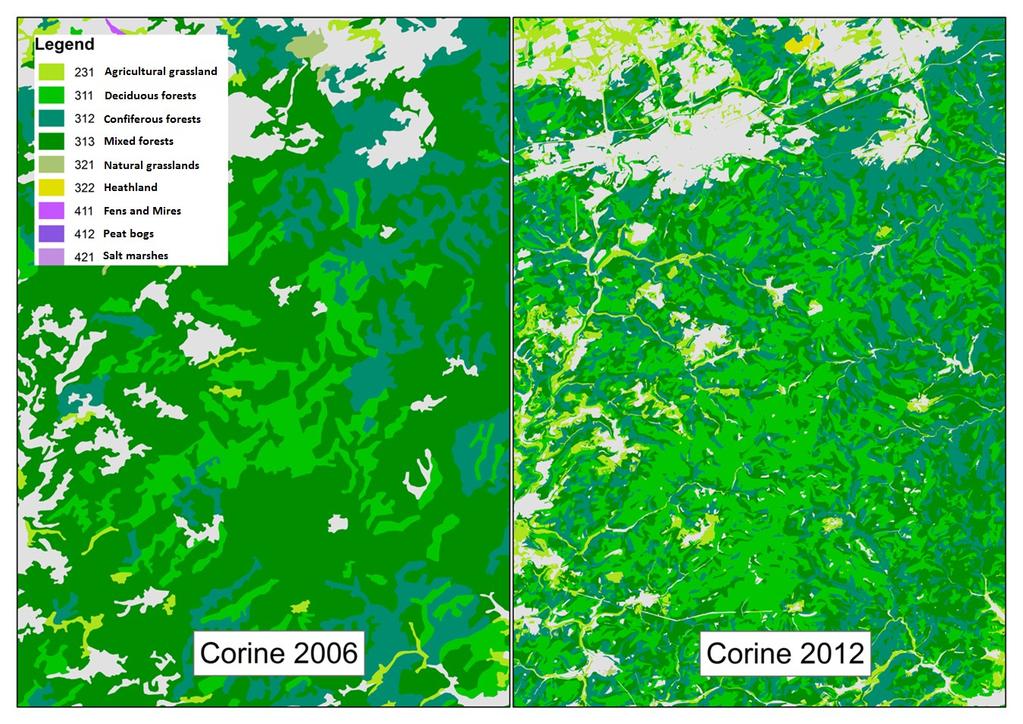
2 The response of the German NFC to the Call for Data focuses on the ical loads based on biodiversity. Despite this, the classical ical loads that protect ecosystems against acidification and / or eutrophication were also submitted. The dataset was completed by information on the protection status of the ecosystems (e.g. SPA or SAC under the NATURA 2000 framework) and an overview of EUNIS classes relevant for Germany. The German dataset consists of 1.26 million records representing about 30 % percent of the territory. What is really new? For the first time the new CORINE 2012 land use data formed the basis for the derivation of ecological receptors. A high-resolution data set with a spatial resolution of one hectare was used. The high resolution of this base layer has the effect that smaller, more sensitive habitats in need of protection have been recorded. In addition due to the broadened scope focusing on biodiversity, the precautionary environmental protection could be expanded
![CORINE - Code Sum of receptor area Description Area in Germany [ha] CORINE 2006 CORINE 2012 Area in Germany Proportion of Area in Germany Area in Germany [%] receptors [%] [ha] [%] Proportion of](/docs-images/76/73686479/images/3-0.jpg "receptors [%] 311 deciduous forests 2366220,163 6,61 21,66 3601127,67 10,05 32,05 312 coniferous forests 5728852,522 16,00 52,44 5584083,67 15,59 49,69 313 mixed forests 2355732,998 6,58 21,57")
3 CORINE - Code Sum of receptor area Description Area in Germany [ha] CORINE 2006 CORINE 2012 Area in Germany Proportion of Area in Germany Area in Germany [%] receptors [%] [ha] [%] Proportion of receptors [%] 311 deciduous forests ,163 6,61 21, ,67 10,05 32, coniferous forests ,522 16,00 52, ,67 15,59 49, mixed forests ,998 6,58 21, ,28 4,43 14, natural grassland ,3142 0,55 1, ,76 0,52 1, heathland ,3036 0,29 0, ,75 0,27 0, fens and mires 49480,8929 0,14 0, ,42 0,19 0, peat bogs ,0292 0,29 0, ,77 0,24 0, salt marshes 16083, ,04 0, ,72 0,07 0, ,39 30, ,05 31, Decrease of mixed forests of nearly % Small changes for coniferous forests (- 2.5 %) Increase of deciduous forests of about + 10 %
4
5
6
7 For the purpose of deriving the appropriate or meaningful receptors the classification scheme used in the CORINE land use dataset was found to be too coarse. For example, in the case of forests, CORINE only distinguishes between deciduous, coniferous and mixed forests. However, the receptors are supposed to consist of site-typical vegetation units, from which the main tree species and characteristic herb and grass species of the forests, woodlands and open land receptors emerge. In order to classify site-typical vegetation species, climate, soil and land use data was combined spatially. From the spatial intersection of the digital CORINE land use map, the differentiated soil survey map of Germany (BÜK1000N) and the climatic regions, 1028 different combination types emerged for the German ical load dataset. From this a total of 233 different plant associations were established in Germany, 132 of which are forest plant communities and 101 open land plant communities. Example: CORINE code + Soil unit + Climate region = Plant community
")


8 Derivation of receptor type BERN- Database: Oak-hornbeam forest (Galio- Carpinetum) intersection of land use type, soil type and regional climate type is resulting in a site typical plant community CORINE 2012 Land use code = 311 deciduous forest German soil map 2014 soil type = eutric cambisol from sandy loess map of precipitation and temperature regional climate type = subcontinental

9 5 perc perc perc perc perc 28.1 average
10 Linking the classical CL approach with biodiversity targets Critical Load for Nitrogen Classical CL Biodiversity CL CL eut CL eut ( N) CLN ( N) Ni Nu Nle( acc) N de max N i N u f (T ) f (H ) N PS *[ N] le( acc) N de f (S) T = Temperature H = Habitat type S = Soil
11 Linking the classical approach with biodiversity targets by the leaching term N PS *[ N] le( acc)
![Base saturation [BS] ÖKO-DATA Distribution of the possibility function of the woodruff beech forest community 16](/docs-images/76/73686479/images/12-0.jpg "15 C/N - ratio Asperulo-Fagetum sylvatici (typ. Subass.")
 BS (bdiv) = point of the ical limits, where the possibility degree function along the edge of the")
12 Base saturation [BS] ÖKO-DATA Distribution of the possibility function of the woodruff beech forest community C/N - ratio Asperulo-Fagetum sylvatici (typ. Subass.) MAYER 1964 Critical C/N ratio to BS value for the reference plant community in favorable ecological conditions C/N (bdiv) BS (bdiv) = point of the ical limits, where the possibility degree function along the edge of the optimum plateau meets the gradient of nutrient imbalance
13 Linking the classical CL approach with biodiversity targets Critical Load for Nutrient Nitrogen to protect from Eutrophication classical CL nut ( N) Ni Nu Nle( acc) N de biodiversity N (acc) = PS * [N] [N] is derived from Table V.5 ICP M&M Mapping Manual CLN max Ni Nu Nle( acc) N de [N] is calculated on basis of C/N (bdiv) according to the BERN database
14 Linking the classical CL approach with biodiversity targets Critical Load of Sulphur to protect from Acidification classical biodiversity CL S CL max S max CL max S BC dep Cldep BCw Bcu ANCle( ) apply equations of the Mapping Manual CL S max BC dep Cldep BCw Bcu ANCle( ) extension with limits of the BERN database
15 1. ANC le( ) PS 2 / 3 1,5 Bc K dep gibb Bc w Bc ( Bc / Al) u 1/ 3 1,5 Bc dep Bc w ( Bc / Al) Bc u 2. ANC ] 3 K H [ H ] while ph log [ H ] ) le( ) PS gibb [ ANC PS Al, and Al 2 BC le( ) ([ H ] le( ) [ Al] le( ) ) while [ Al] le( ) w w w 3 4. ANC le( ) PS ([ H] ( Kgibb[ H] ) ) while [ H ] K Gap 100 [ Bc] BS ( geo) 1 5. ANC le( ) PS ([ H ] ( K gibb [ H ] ) 3 ) while [ H ] K Gap 100 [ Bc] BS ( phyto) 1 and K gap k HBc k 1 AlBc K 1 3 gibb CL max S = min{ CL(1) ; CL(2) ; CL(3) CL(4)} CL S max = min{ CL(1) ; CL(2) ; CL(3) CL(4) ; CL(5)}
16 Preliminary results of ical load computation:

17 Thank you all! I wish you the best and continued success with our projects for clean air in Europe
Concepts for defining habitat distribution and validating habitat cluster potential
 23th CCE Workshop Copenhagen, 08.-11.04.2013 Concepts for defining habitat distribution and validating habitat cluster potential T. Scheuschner, German NFC Structure: - Introduction - Work for the current
SIF_7.1_v2. Indicator. Measurement. What should the measurement tell us?
 Indicator 7 Area of natural and semi-natural habitat Measurement 7.1 Area of natural and semi-natural habitat What should the measurement tell us? Natural habitats are considered the land and water areas
Supplementary material: Methodological annex
 1 Supplementary material: Methodological annex Correcting the spatial representation bias: the grid sample approach Our land-use time series used non-ideal data sources, which differed in spatial and thematic
Critical Loads of Acidity Database This project was funded, in part, by the USDA Forest Service National Forest System National Air Technical Program.
 Critical Loads of Acidity Database This project was funded, in part, by the USDA Forest Service National Forest System National Air Technical Program. Database Overview This database was created to provide
Instructions for Submitting Critical Loads of N and S and Dynamic Modelling Data
 Instructions for Submitting Critical Loads of N and S and Dynamic Modelling Data Introduction Coordination Centre for Effects (CCE), Bilthoven, November 2007 This document contains the instructions for
Global Land Cover Mapping
 Global Land Cover Mapping and its application in SDGs Prof. Chen Jun 1, Dr. He Chaoying 2 1 National Geomatics Center of China (NGCC) 2 Ministry of Natural Resources, P.R.China May 30, 2018, Copenhagen
UK NEA Economic Analysis Report Cultural services: Mourato et al. 2010
 Appendix A Hedonic regressions: Further data description The environmental data used to construct variables for the hedonic regressions come from the Centre for Ecology and Hydrology, the Generalised Land
Introduction. Ecology is the scientific study of the interactions between organisms and their environment.
 Introduction Ecology is the scientific study of the interactions between organisms and their environment. 1. The interactions between organisms and their environments determine the distribution and abundance
Ecosystems Chapter 4. What is an Ecosystem? Section 4-1
 Ecosystems Chapter 4 What is an Ecosystem? Section 4-1 Ecosystems Key Idea: An ecosystem includes a community of organisms and their physical environment. A community is a group of various species that
Object based modelling of habitats with EO data: Semantic and technical challenges to achieve interoperability
 Object based modelling of habitats with EO data: Semantic and technical challenges to achieve interoperability Michael Bock, DLR Space Agency 1.07.2010 Folie 1 Vortrag > Autor > Dokumentname > 09.11.2005
Name Hour. Chapter 4 Review
 Name Hour Chapter 4 Review 1. The average, year-after-year conditions of temperature and precipitation within a particular region are its weather. climate. greenhouse effect. d. biotic factors. 2. The
The mapping of habitats: an indispensable tool to the planning and management of protected areas in Catalonia
 The mapping of habitats: an indispensable tool to the planning and management of protected areas in Catalonia Palau de Congressos de Catalunya Barcelona, 27 September 2016 Introduction Agoodcartographic
Environmental Science
 Environmental Science A Study of Interrelationships Cui Jiansheng Hebei University of Science and Technology CH06 Kinds of Ecosystems and Communities Chapter Objectives After reading this chapter, you
World Geography 3202 Practice Multiple Choice Unit 3 Ecosystems. Outcomes:
 Outcomes: SCO 3.1: The student will be expected to demonstrate an understanding that an ecosystem consists of a complex network of organisms, including the following delineations: 3.1.1 Define the term
forest tropical jungle swamp marsh prairie savanna pampas Different Ecosystems (rainforest)
") Different Ecosystems forest A region of land that is covered with many trees and shrubs. tropical jungle (rainforest) swamp A region with dense trees and a variety of plant life. It has a tropical climate.
Different Ecosystems forest A region of land that is covered with many trees and shrubs. tropical jungle (rainforest) swamp A region with dense trees and a variety of plant life. It has a tropical climate.
GIS and Coastal Nutrients Luke Cole
 GIS and Coastal Nutrients Luke Cole Human population density has been widely utilized as a valid predictor of terrestrial nitrogen loads into marine systems. As 50% of the world s population lives within
Habitats habitat concept, identification, methodology for habitat mapping, organization of mapping
 Habitats habitat concept, identification, methodology for habitat mapping, organization of mapping Rastislav Lasák & Ján Šeffer Training Implementation of Habitats Directive - Habitats and Plants 1 What
Biome PSC CIRCLE PSC CIRCLE
 Biome 1. Terrestrial part of Bio sphere is divided into enormous regions which are characterized by specific species living there, called as Biomes. 2. The 2 most important climatic factors that determine
AGOG 485/585 /APLN 533 Spring Lecture 5: MODIS land cover product (MCD12Q1). Additional sources of MODIS data
. Additional sources of MODIS data") AGOG 485/585 /APLN 533 Spring 2019 Lecture 5: MODIS land cover product (MCD12Q1). Additional sources of MODIS data Outline Current status of land cover products Overview of the MCD12Q1 algorithm Mapping
AGOG 485/585 /APLN 533 Spring 2019 Lecture 5: MODIS land cover product (MCD12Q1). Additional sources of MODIS data Outline Current status of land cover products Overview of the MCD12Q1 algorithm Mapping
Evaluating Wildlife Habitats
 Lesson C5 4 Evaluating Wildlife Habitats Unit C. Animal Wildlife Management Problem Area 5. Game Animals Management Lesson 4. Evaluating Wildlife Habitats New Mexico Content Standard: Pathway Strand: Natural
Lecture 24 Plant Ecology
 Lecture 24 Plant Ecology Understanding the spatial pattern of plant diversity Ecology: interaction of organisms with their physical environment and with one another 1 Such interactions occur on multiple
Wisconsin River Floodplain Project: Overview and Plot Metadata
 Wisconsin River Floodplain Project: Overview and Plot Metadata CLASS I. DATA SET DESCRIPTORS Data set identity: Plot-level variable information for Wisconsin River Floodplain Project. Relevant for following
Empirical critical loads for nitrogen for ecoregions of the US: current and future. Linda Pardo Linda Geiser Jason Lynch Mark Fenn
 Empirical critical loads for nitrogen for ecoregions of the US: current and future Linda Pardo Linda Geiser Jason Lynch Mark Fenn Outline 1. Background on critical loads 2. Empirical critical loads for
The Norwegian monitoring program for sub-alpine birch-forests
 The Norwegian monitoring program for sub-alpine birch-forests Effects of air pollution and climate change on ground vegetation Vegar Bakkestuen & Per Arild Aarrestad Norwegian sub-alpine birch-forests
Biomes and Ecosystems
 Name Biomes and Ecosystems Date How do Earth s biomes and ecosystems differ? Before You Read Before you read the chapter, think about what you know about biomes and ecosystems Record your thoughts in the
Ecosystem Review. EOG released questions
 Ecosystem Review EOG released questions 1. Which food chain is in the correct order? A grasshopper grass snake frog hawk B grasshopper frog hawk snake grass C grass grasshopper frog snake hawk D grass
Ecology 312 SI STEVEN F. Last Session: Aquatic Biomes, Review This Session: Plate Tectonics, Lecture Quiz 2
 Ecology 312 SI STEVEN F. Last Session: Aquatic Biomes, Review This Session: Plate Tectonics, Lecture Quiz 2 Questions? Warm up: KWL KNOW: On a piece of paper, write down things that you know well enough
Lesson 2: Terrestrial Ecosystems
 Lesson 2: Terrestrial Ecosystems A terrestrial ecosystem is a land ecosystem. Terrestrial ecosystems include tundra, forests, grasslands, deserts, and rainforests. 1 The arctic tundra is earth s coldest
Chapter 52 An Introduction to Ecology and the Biosphere
 Chapter 52 An Introduction to Ecology and the Biosphere Ecology The study of the interactions between organisms and their environment. Ecology Integrates all areas of biological research and informs environmental
The Combination of Geospatial Data with Statistical Data for SDG Indicators
 Session x: Sustainable Development Goals, SDG indicators The Combination of Geospatial Data with Statistical Data for SDG Indicators Pier-Giorgio Zaccheddu Fabio Volpe 5-8 December2018, Nairobi IAEG SDG
DRAFT DOCUMENT (August 2014) Prepared by AC Le Gall (ICP M&M), reviewed by M. Posch (CCE) To be reviewed by ICP M&M NFCs VII. EXCEEDANCE CALCULATIONS
 Prepared by AC Le Gall (ICP M&M), reviewed by M. Posch (CCE) To be reviewed by ICP M&M NFCs VII. EXCEEDANCE CALCULATIONS") DRAFT DOCUMENT (August 204) Prepared by AC Le Gall (ICP M&M), reviewed by M. Posch (CCE) To be reviewed by ICP M&M NFCs VII. EXCEEDANCE CALCULATIONS Updated by Max Posch, CCE, and Anne Christine Le Gall,
DRAFT DOCUMENT (August 204) Prepared by AC Le Gall (ICP M&M), reviewed by M. Posch (CCE) To be reviewed by ICP M&M NFCs VII. EXCEEDANCE CALCULATIONS Updated by Max Posch, CCE, and Anne Christine Le Gall,
5 th Grade Ecosystems Mini Assessment Name # Date. Name # Date
 An ecosystem is a community of organisms and their interaction with their environment. (abiotic, biotic, niche, habitat, population, community)- 1. Which effect does a decrease in sunlight have on a pond
Nutrient Cycling in Land Vegetation and Soils
 Nutrient Cycling in Land Vegetation and Soils OCN 401 - Biogeochemical Systems 13 September 2012 Reading: Schlesinger, Chapter 6 Outline 1. The annual Intrasystem Nutrient Cycle 2. Mass balance of the
Canadian Geography Final Exam Review (September to Mid-term Exam)
") Canadian Geography 1202 - Final Exam Review (September to Mid-term Exam) Glossary Terms: Some of the following terms may be covered in the questions that follow. System Natural System Ecosystem Human System
Canadian Geography 1202 - Final Exam Review (September to Mid-term Exam) Glossary Terms: Some of the following terms may be covered in the questions that follow. System Natural System Ecosystem Human System
Organism Species Population Community Ecosystem
 Name: Date: Period: Ecosystems and Their Interactions S8.B.3.1 Getting the idea The environment is everything that surrounds an organism. Organisms cooperate and compete with each other to get everything
Predicting ectotherm disease vector spread. - Benefits from multi-disciplinary approaches and directions forward
 Predicting ectotherm disease vector spread - Benefits from multi-disciplinary approaches and directions forward Naturwissenschaften Stephanie Margarete THOMAS, Carl BEIERKUHNLEIN, Department of Biogeography,
Utility of National Spatial Data for Conservation Design Projects
 Utility of National Spatial Data for Conservation Design Projects Steve Williams Biodiversity and Spatial Information Center North Carolina State University PIF CDW St. Louis, MO April 11, 2006 Types of
CHAPTER 6 & 7 VOCABULARY
 CHAPTER 6 & 7 VOCABULARY 1. Biome 2. Climate 3. Latitude 4. Altitude 5. Emergent layer 6. Epiphyte 7. Understory 8. Permafrost 9. Wetland 10.Plankton 11.Nekton 12.Benthos 13.Littoral zone 14.Benthic zone
Discuss the impact of biotic and abiotic factors on their environment and the significant ecological levels of organization.
 Learning Targets Discuss the impact of biotic and abiotic factors on their environment and the significant ecological levels of organization. Explain the difference between an organism s habitat and niche
The stability of ecological corridors as illustrated by examples from Poland
 Gerlée A., 11. The stability of ecological corridors as illustrated by examples from Poland. The Problems of Landscape Ecology. Vol. XXX. 371-376. The stability of ecological corridors as illustrated by
Biosphere Biome Ecosystem Community Population Organism
 Ecology ecology - The study of living things and how they relate to their environment Levels of Organization in Ecology organism lowest level one living thing population collection of organisms of the
The following statements will be changed into TRUE/FALSE Questions. STUDY! (Hi-light important info)
") BIOME STUDY GUIDE!!!! ~There will be a map on your Biome Exam! ~ You will also need to know and understand the zones of the marine and freshwater biomes. ~FYI- I will collect your Biome Suitcases on WEDNESDAY
BIOME STUDY GUIDE!!!! ~There will be a map on your Biome Exam! ~ You will also need to know and understand the zones of the marine and freshwater biomes. ~FYI- I will collect your Biome Suitcases on WEDNESDAY
TEST NAME: Biome Test 10/7 TEST ID: GRADE:05 - Fifth Grade SUBJECT:Life and Physical Sciences TEST CATEGORY: My Classroom
 TEST NAME: Biome Test 10/7 TEST ID:1239163 GRADE:05 - Fifth Grade SUBJECT:Life and Physical Sciences TEST CATEGORY: My Classroom Biome Test 10/7 Page 1 of 8 10/07/16, Biome Test 10/7 Student: Class: Date:
Biomes Section 1. Chapter 6: Biomes Section 1: What is a Biome? DAY ONE
 Chapter 6: Biomes Section 1: What is a Biome? DAY ONE What is a Biome? Biomes are large regions characterized by a specific type of climate and certain types of plant and animal communities. The climate
European Topic Centre on Land Urban and Soil Systems. Green Infrastructure at EEA
 Green Infrastructure at EEA A SPATIAL APPROACH TO MAPPING GI Stefan Kleeschulte, ETC ULS GI and territorial cohesion 2011 first EEA report on Green Infrastructure Underlining the need to develop tools
Global Biogeography. Natural Vegetation. Structure and Life-Forms of Plants. Terrestrial Ecosystems-The Biomes
 Global Biogeography Natural Vegetation Structure and Life-Forms of Plants Terrestrial Ecosystems-The Biomes Natural Vegetation natural vegetation is the plant cover that develops with little or no human
Mapping and Assessment of Ecosystems and their Services
 Mapping and Assessment of Ecosystems and their Services ALTER-Net Conference 2013: Science underpinning the EU 2020 Biodiversity Strategy. April 2013 Gent Joachim MAES 1 This presentation is based on the
Environments and Ecosystems
 Environments and Ecosystems A habitat is a place where organisms naturally live and grow. Habitats include biotic, living factors, such as plants and animals and abiotic, non-living factors, such as rocks,
VII. EXCEEDANCE CALCULATIONS
 VII. EXCEEDANCE CALCULATIONS Updated by Max Posch, CCE, from the initial text of the Mapping Manual 2004 Please refer to this document as: CLRTAP, 2015. Exceedance calculations, Chapter VII of Manual on
APEX for heathland and coastal vegetation monitoring applications: first results and ongoing activities
 10/09/2012 APEX for heathland and coastal vegetation monitoring applications: first results and ongoing activities Birgen Haest Jeroen Vanden Borre,Toon Spanhove, Luc Bertels, Markus Reinhold, Sebastien
C o p e r n i c u s L a n d M o n i t o r i n g S e r v i c e
 C o p e r n i c u s L a n d M o n i t o r i n g S e r v i c e Submodule D: stability of protected areas & related pressures: Natura2000 sites Copernicus EU Copernicus EU Copernicus EU www.copernicus.eu
2.1.2 Land cover data
 2.1.2 Land cover data Land cover data was used as an approximate measure of the different habitat groupings throughout Britain. Land cover data was obtained from three sources The European Environment
Natura 2000 in the marine environment: state of implementation and next steps
 Life on the blue planet: biodiversity research and the new European marine policies EPBRS European Platform on Biodiversity Research Strategy Porto, Portugal 7-9 November 2007 Natura 2000 in the marine
GERMANY-WIDE COMPARISON OF
 GERMANY-WIDE COMPARISON OF SPATIAL DISTRIBUTION OF NITROGEN CONCENTRATIONS AND STABLE ISOTOPE SIGNATURES OF BRYOPHYTES AND LICHENS Boltersdorf SH, Pesch R, Schröder W, Werner W 26 th Task Force Meeting
Ecosystems. Component 3: Contemporary Themes in Geography 32% of the A Level
 Ecosystems Component 3: Contemporary Themes in Geography 32% of the A Level Component 3 Written exam: 2hrs 15mins Section A Tectonic Hazards One compulsory extended response question 38 marks Section B
Continue 59 Invasive. Yes. Place on invasive plant list, no further investigation needed. STOP. No. Continue on to question 2.
 Ohio Plant Assessment Protocol Posted Date: 7/2/ Step II Outcome: Directions: Place an "" in the Score column next to the selected answer to each of the four questions.. Is this plant known to occur in
VSD+ PROPS. Luc Bonten, Janet Mol, Wieger Wamelink, Gert Jan Reinds, Jan-Cees Voogd
 VSD+ PROPS Luc Bonten, Janet Mol, Wieger Wamelink, Gert Jan Reinds, Jan-Cees Voogd Contents VSD+, what is new PROPS What is PROPS Extension of number of species in PROPS Limit number of species in PROPS
An Update on Land Use & Land Cover Mapping in Ireland
 An Update on Land Use & Land Cover Mapping in Ireland Progress Towards a National Programme Kevin Lydon k.lydon@epa.ie Office of Environmental Assessment, Environmental Protection Agency, Johnstown Castle,
Ecosystem-Climate Interactions
 Ecosystem-Climate Interactions Dennis Baldocchi UC Berkeley 2/1/2013 Topics Climate and Vegetation Correspondence Holdredge Classification Plant Functional Types Plant-Climate Interactions Canopy Microclimate
Ecosystem classification in the Central Rocky Mountains, Utah
 Ecosystem classification in the Central Rocky Mountains, Utah Introduction Societal demand for sustainable natural resources: Manage ecosystems rather than individual resources; ecosystem-specific approach
Harrison 1. Identifying Wetlands by GIS Software Submitted July 30, ,470 words By Catherine Harrison University of Virginia
 Harrison 1 Identifying Wetlands by GIS Software Submitted July 30, 2015 4,470 words By Catherine Harrison University of Virginia cch2fy@virginia.edu Harrison 2 ABSTRACT The Virginia Department of Transportation
Biomes of the World Roxanne Coffey Ms. Coffey
 Biomes of the World Roxanne Coffey Ms. Coffey DECIDUOUS FOREST DESCRIPTION The Deciduous Forest is a biome that is found throughout many parts of the world. It can be found on the Eastern side of North
Honors Biology Unit 5 Chapter 34 THE BIOSPHERE: AN INTRODUCTION TO EARTH S DIVERSE ENVIRONMENTS
 Honors Biology Unit 5 Chapter 34 THE BIOSPHERE: AN INTRODUCTION TO EARTH S DIVERSE ENVIRONMENTS 1. aquatic biomes photic zone aphotic zone 2. 9 terrestrial (land) biomes tropical rain forest savannah (tropical
1 Introduction. 1.1 The critical load and level concept in the UNECE Convention on Long-range Transboundary Air Pollution
 Mapping Manual 2004 Chapter 1 has been edited by Till Spranger (Germany), Chairman of the Task Force on Modelling and Mapping. The critical loads and levels concept is an effect-based approach that has
Biomes and Biodiversity
 Biomes and Biodiversity Agenda 2/4/13 Biomes review terrestrial and aquatic Biodiversity Climate Change Introduction Weather Terrestrial Biomes Review Tundra Boreal Forest (Taiga) Temperate Forest Temperate
Biodiversity Blueprint Overview
 Biodiversity Blueprint Overview Climate Variability Climate projections for the Glenelg Hopkins Regions suggest that the weather will be hotter and drier in the coming years which will impact on land use,
Calculating the Natura 2000 network area in Europe: The GIS approach
 Calculating the Natura 2000 network area in Europe: The GIS approach 1. INTRODUCTION A precise area calculation is needed to check to what extent member states have designated Natura 2000 sites of their
Good Morning! When the bell rings we will be filling out AP Paper work.
 Good Morning! Turn in HW into bin or email to smithm9@fultonschools.org If you do not want to tear the lab out of your notebook take a picture and email it. When the bell rings we will be filling out AP
Geography Revision Guide: The Living World (Ecosystems) 1. What is an ecosystem?
 1. What is an ecosystem?") Geography Revision Guide: The Living World (Ecosystems) 1. What is an ecosystem? An ecosystem is community of plants and animals living together in a habitat. The lives of the plants and animals are closely
Geography Revision Guide: The Living World (Ecosystems) 1. What is an ecosystem? An ecosystem is community of plants and animals living together in a habitat. The lives of the plants and animals are closely
Differential impacts of Pleistocene mega-herbivores on nitrogen availability
 Differential impacts of Pleistocene mega-herbivores on nitrogen availability Elizabeth S. Jeffers Long Term Ecology Laboratory Department of Zoology University of Oxford Extinctions were coincident with
Biology and the hierarchies of life. finer scale. coarser scale. individual. populations. metapopulation. community. ecosystem. biome.
 Biology and the hierarchies of life finer scale individual populations metapopulation community ecosystem biome coarser scale biosphere 1 Communities: all species that live together in one place Eucalypt
EAGLE concept, as part of the HELM vision
 EAGLE concept, as part of the HELM vision EAGLE working group Barbara Kosztra (Hungary), Stephan Arnold (Germany), Lena Hallin-Pihlatie & Elise Järvenpää (Finland) 16.06.2014 HELM / EAGLE Workshop - INSPIRE
Name Date Class. well as the inland, found near the Tropics. 4. In the, or the regions near the Equator, you may find a lush
 WATER, CLIMATE, AND VEGETATION Vocabulary Activity DIRECTIONS: Fill in the Blanks Select a term from below to complete each of the following sentences. CHAPTER 1. The constant movement of water, a process
Accounting for Ecosystem and Biodiversity Related Themes in Uganda
 Introduction Accounting for Ecosystem and Biodiversity Related Themes in Uganda Calls for more evidence-based approaches to policy have increased the need for integrated environmental-economic information
Ms. A. Mormando's Class *
 8 th Grade Science Essential Standard: 8.E.1.1 Explain the structure of the hydrosphere including: Water distribution on Earth; Local river basin and water availability Stream - A stream is a body of water
Earth s Major Terrerstrial Biomes. *Wetlands (found all over Earth)
") Biomes Biome: the major types of terrestrial ecosystems determined primarily by climate 2 main factors: Depends on ; proximity to ocean; and air and ocean circulation patterns Similar traits of plants
Biomes Biome: the major types of terrestrial ecosystems determined primarily by climate 2 main factors: Depends on ; proximity to ocean; and air and ocean circulation patterns Similar traits of plants
LUCAS: current product and its evolutions
 LUCAS: current product and its evolutions Workshop Land Use and Land Cover products: challenges and opportunities Brussels 15 Nov 2017 Eurostat E4: estat-dl-lucas@ec.europa.eu Contents 1) The context 2)
AP Biology. Environmental factors. Earth s biomes. Marine. Tropical rainforest. Savanna. Desert. Abiotic factors. Biotic factors
 Earth s biomes Environmental factors Abiotic factors non-living chemical & physical factors temperature light water nutrients Biotic factors living components animals plants Marine Tropical rainforest
Impact of increased inorganic nitrogen deposition on the mycorrhizal community
 Eastern CANUSA Forest Science Conference Impact of increased inorganic nitrogen deposition on the mycorrhizal community Adam Bordeleau, Hubert Morin, Sergio Rossi et Daniel Houle 1 Ectomycorrhiza Symbiotic
Overview of Chapter 6
 Chapter 6 Major Ecosystems of the World Overview of Chapter 6 Earth s Major Biomes Aquatic Ecosystems Freshwater ecosystems Estuaries Marine Ecosystems Interaction of Life Zones and Humans Earth s Major
Chapter 6 Major Ecosystems of the World
 Chapter 6 Major Ecosystems of the World Overview of Chapter 6 Earth s Major Biomes Aquatic Ecosystems Freshwater ecosystems Estuaries Marine Ecosystems Interaction of Life Zones and Humans Earth s Major
Chapter 7 Part III: Biomes
 Chapter 7 Part III: Biomes Biomes Biome: the major types of terrestrial ecosystems determined primarily by climate 2 main factors: Temperature and precipitation Depends on latitude or altitude; proximity
Major Ecosystems of the World
 6 Major Ecosystems of the World Overview of Chapter 6 Earth s Major Biomes Aquatic Ecosystems Freshwater ecosystems Estuaries Marine Ecosystems Interaction of Life Zones and Humans Earth s Major Biomes
W I N D R E S O U R C E A S S E S S M E N T
 W I N D R E S O U R C E A S S E S S M E N T Annual Energy Production Project: Hundhammer_WS_Express Layout: Layout1 Customer: WindSim 2014-01-29 WindSim AS Fjordgaten 15, N- 3125 Tønsberg, Norway phone.:
Overview of Remote Sensing in Natural Resources Mapping
 Overview of Remote Sensing in Natural Resources Mapping What is remote sensing? Why remote sensing? Examples of remote sensing in natural resources mapping Class goals What is Remote Sensing A remote sensing
Fundamentals of THE PHYSICAL ENVIRONMENT. David Briggs, Peter Smithson, Kenneth Addison and Ken Atkinson
 Fundamentals of THE PHYSICAL ENVIRONMENT Second Edition David Briggs, Peter Smithson, Kenneth Addison and Ken Atkinson LONDON AND NEW YORK Contents L,ISI Of colour piates List of black and white plates
EQ: What is ECOLOGY and the levels of organization used when studying it?
 EQ: What is ECOLOGY and the levels of organization used when studying it? ECOLOGY is the scientific study of interactions among organisms with each other and with the environment. The German biologist
1.3 What are the needs of Organisms? *Autotrophs: organisms that can (i.e. plants) *Heterotrophs: organisms that (i.e. humans)
 *Heterotrophs: organisms that (i.e. humans)") 1.3 What are the needs of Organisms? 5 Things Living Organisms Need 1- -Organisms get energy from in order to. *Autotrophs: organisms that can (i.e. plants) *Heterotrophs: organisms that (i.e. humans)
1.3 What are the needs of Organisms? 5 Things Living Organisms Need 1- -Organisms get energy from in order to. *Autotrophs: organisms that can (i.e. plants) *Heterotrophs: organisms that (i.e. humans)
Identification of Areas With Natural Constraints Case Study Serbia
 Identification of Areas With Natural Constraints Case Study Serbia Dragana Vidojević of the Environmental Protection Agency, Ruže Jovanovića St. 27a, 11160 Belgrade, dragana.vidojevic@sepa.gov.rs; Jovica
Spatial Disaggregation of Land Cover and Cropping Information: Current Results and Further steps
 CAPRI CAPRI Spatial Disaggregation of Land Cover and Cropping Information: Current Results and Further steps Renate Koeble, Adrian Leip (Joint Research Centre) Markus Kempen (Universitaet Bonn) JRC-AL
remain on the trees all year long) Example: Beaverlodge, Alberta, Canada
 Example: Beaverlodge, Alberta, Canada") Coniferous Forest Temperature: -40 C to 20 C, average summer temperature is 10 C Precipitation: 300 to 900 millimeters of rain per year Vegetation: Coniferous-evergreen trees (trees that produce cones
Coniferous Forest Temperature: -40 C to 20 C, average summer temperature is 10 C Precipitation: 300 to 900 millimeters of rain per year Vegetation: Coniferous-evergreen trees (trees that produce cones
Copernicus for Coastal Zone Monitoring and Management
 Copernicus for Coastal Zone Monitoring and Management DG-Grow, 29 June 2017 User Requirement Perspective: Monitoring of coastal zones, pressures and impacts on nature and people Courtesy: J. Ekebom storm
The area on and near the Earth s surface where living things exist. The biosphere:
 The area on and near the Earth s surface where living things exist The biosphere: The Biosphere If you use an apple to model the world, which part of the apple would represent the biosphere? Today define:
Define Ecology. study of the interactions that take place among organisms and their environment
 Ecology Define Ecology Define Ecology study of the interactions that take place among organisms and their environment Describe each of the following terms: Biosphere Biotic Abiotic Describe each of the
Physiological (Ecology of North American Plant Communities
 Physiological (Ecology of North American Plant Communities EDITED BY BRIAN F. CHABOT Section of Ecology and Systematics Cornell University AND HAROLD A. MOONEY Department of Biological Sciences Stanford
Module 3. Basic Ecological Principles
 Module 3. Basic Ecological Principles Ecosystem Components Abiotic Biotic Species & Habitat The Biomes of North America Communities Energy & Matter Cycles in Ecosystems Primary Productivity Simple Ecosystem
Modeling CO 2 sinks and sources of European land vegetation using remote sensing data
 Modeling CO 2 sinks and sources of European land vegetation using remote sensing data K. Wißkirchen, K. Günther German Aerospace Center (DLR), German Remote Sensing Data Center (DFD), Climate and Atmospheric
Name Hour. Section 4-1 The Role of Climate (pages 87-89) What Is Climate? (page 87) 1. How is weather different from climate?
 What Is Climate? (page 87) 1. How is weather different from climate?") Name Hour Section 4-1 The Role of Climate (pages 87-89) What Is Climate? (page 87) 1. How is weather different from climate? 2. What factors cause climate? The Greenhouse Effect (page 87) 3. Circle the
Name Hour Section 4-1 The Role of Climate (pages 87-89) What Is Climate? (page 87) 1. How is weather different from climate? 2. What factors cause climate? The Greenhouse Effect (page 87) 3. Circle the
Looking at the big picture to plan land treatments
 Looking at the big picture to plan land treatments Eva Strand Department of Rangeland Ecology and Management University of Idaho evas@uidaho.edu, http://www.cnr.uidaho.edu/range Why land treatment planning?
the Clinch/Hidden Valley study site were used in this mountainous classification.
 the Clinch/Hidden Valley study site were used in this mountainous classification. Deciduous forest was present on over half of the image (Table 97). Coniferous forest and herbaceous were the only other