U.S. Sites for CTA NORTH
|
|
|
- Percival Anthony
- 5 years ago
- Views:
Transcription


1 U.S. Sites for CTA NORTH CTA-US and SCT Meeting SLAC, 24 February 2012 Karen Byrum, Jeff Hall, Dave Kieda, Ken Gibbs Pratik Majumdar, Rene Ong, and Andy Smith (CTA-US SITE Working Group)
2 Outline Major Update from previous meetings (New York 2/11, Toulouse 5/11 and Madrid 11/11) a huge amount of work has been done. Introduce: General features of N. Arizona Site selection process Two sites in the proposal p - Meteor Crater and Yavapai Ranch Review (quickly) the extensive material gathered on sites Key Issues: Cloud cover and night sky background Monsoons and lightning Why more than one site? Where do we go from here? US Site Visit (Feb 27-28), CTA SITE WP Mtg (Mar 1-3) Next talks: Jeff Hall Lowell Observatory as partner and host Gagik Tovmassian SPM, US-Mexico partnership


3 State of Arizona Large state ~300,000 km 2 Lowell Major International Airports: Las Vegas Phoenix Observatory City of Flagstaff (pop: 65,000) VERITAS
![Arizona Weather Temperature range for northern Arizona sites [7].](/docs-images/89/98358158/images/4-1.jpg "The average high temperatures (red) and low temperatures (blue) are shown for")

![of Arizona [8]. The legend at right indicates totals in inches.](/docs-images/89/98358158/images/4-3.jpg "The proposed sites for CTA are indicated by the red circles.")
4 Arizona Weather Temperature range for northern Arizona sites [7]. The average high temperatures (red) and low temperatures (blue) are shown for Winslow, AZ % (inner band) and 10-90% (outer band) ranges are also shown. Reasonable temperature range Map of total annual precipitation for the state of Arizona [8]. The legend at right indicates totals in inches. The proposed sites for CTA are indicated by the red circles. Low precipitation (lower than VERITAS site)
![Wind, Solar Map of average wind speeds for northern Arizona [5].](/docs-images/89/98358158/images/5-1.jpg "The legend on the right indicates the color classification of")
 are in the Poor or Marginal")


![Southwest [11].](/docs-images/89/98358158/images/5-6.jpg "The proposed sites are indicated by the red circles.")
5 Wind, Solar Map of average wind speeds for northern Arizona [5]. The legend on the right indicates the color classification of different areas for viability for wind power generation. Both proposed CTA sites (red circles) are in the Poor or Marginal wind power classifications. These measurements were made at a height of 30m above ground level. Wind speeds at 10m above ground level are expected to be lower [10]. Map of direct normal solar radiation for the U.S. Southwest [11]. The proposed sites are indicated by the red circles. Good sky conditions Moderate winds Note: alternative ti energy possibilities are very good for these sites and need to be fully explored


6 Population Density Map of population density of Arizona from the Census of 2010 [19]. The blue plus symbols indicate the locations of the two sites proposed for CTA. (The distance between the sites is approximately 180 km).
7 Flagstaff

8 Flagstaff
9 B Flagstaff C A
10 B Flagstaff C A


.")

11 Arizona Land Pattern Arizona has a unique land ownership pattern that dates back to original settlement and the building of the railroad across state. Sunshine: Power, Internet Highway, & Railroad Checkerboard pattern of Private land and State Trust land. Squares of 1mi x 1mi (1.6 km x 1.6 km). Private land was consolidated into large ranches. CTA Perfect match for size of CTA North! Private land = much less difficulty for permitting Meteor Crater site
12 Coconino and Yavapai Counties Coconino County: Large and sparsely populated ~50,000 km 2, second largest county in US-48 states Population ~ 135,000 (~half in Flagstaff) i.e. larger than Switzerland and 1/6 population of Tenerife Yavapai County ~21,000 km 2 Population ~ 210,
13 Proposed Sites New: X-One Ranch West Site: Yavapai Ranch East Site: Meteor Crater Map of a portion of Arizona near Flagstaff, AZ. The access routes from the East Site (A) and the West Site (B) to Flagstaff (C) are shown in blue. The Grand Canyon starts at the top of the figure.


14 Meteor Crater Site Very Flat! Satellite views of the East Site, showing the proposed CTA location and the elevation profile.


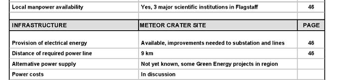
15 Meteor Crater Site Very flat, no vegetation 1677m elevation Excellent access short distance and high-quality road to Interstate-40. Railroad very close by Power nearby, but needs upgrade Excellent synergy with Meteor Crater (technical, outreach)

, shown relative to")


16 Yavapai Ranch Site Williamson Valley Rd. Satellite view of West Site (red circle), shown relative to Interstate 40 (yellow) and Seligman. The distance from I-40 to the site is 25 km. Map of Yavapai Ranch LC holdings. Parcels 1 and 11 are the top site candidates. Parcel 11 was selected as the proposed site for CTA, with Parcel 1 as a second option. The Williamson Valley Rd traverses the Ranch passing 2 km W of Parcel 11 and adjacent to Parcel 1.


17 Yavapai Ranch Site Very flat Very flat, little vegetation 1670m elevation More remote than Meteor Crater 25 km to I-40, railroad Power nearby, but needs upgrade Borders Forest Service land
18 Yavapai Ranch Site
19 Extensive Info for Each Site Detailed, complete technical data for the sites: Geophysical: terrain, soil, magnetic field, rigidity cutoff Atmospheric: climatic conditions, cloud cover Infrastructure: roads, railroad, nearby towns/facilities Services: power, Internet, water, waste management, medical services Construction/operation: concrete, cranes, housing, office space Hazards: thunderstorms, seismic activity, hurricanes, tornadoes, volcanic, animals, crime and security Permitting, customs Intellectual, economic, and political aspects: Lowell observatory major research facility Regional university partners NAU, ASU, UNLV Political and economic support county, state, industry Excellent outreach potential


20 Complete Matrix for Each Site
21 Multiple Sites = Multiple Options Meteor Crater Yavapai Ranch X-One Ranch Geophysical Very Good Excellent Excellent Hazards/Risk V. Low V. Low V. Low Cloud cover and NSB V. Good V. Good Excellent Access, Services Excellent Good Good Construction/Operation Excellent Good Good Land Acquisition No Issues FS SUP No Issues Outreach/Visitors Center At Site Flagstaff? Flagstaff? The sites are not identical Still early in site selection ec process makes sense to keep good alternate possibilities, since they exist Review committee(s)/consortium will refine criteria

, f VERITAS and the Lowell")


22 Local University Partners Map of Arizona showing the major transportation hubs (green squares), the locations of p f g j p (g q ), f VERITAS and the Lowell observatory (blue stars) and the locations of the two proposed sites for CTA (red circles). The locations of three nearby universities (ASU, NAU, UNLV) are shown. The major highways are indicated by red lines. The primary rail line goes east-west through Flagstaff.
23 Tremendous Outreach Potential A major destination but sparsely populated. 200 km Grand Canyon (2M visitors) CTA! Las Vegas Meteor Crater (200K visitors) Route 66 Sedona CTA Meeting (Madrid), Nov U.S. Sites for CTA North Rene A. Ong


, Nov. 2011 U.")
24 Tremendous Outreach Potential A major destination but sparsely populated. Seligman, AZ 200 km Grand Canyon CTA! Las Vegas Seligman Meteor Crater Route 66 Sedona CTA Meeting (Madrid), Nov U.S. Sites for CTA North Rene A. Ong
25 Some key remaining issues: Night sky background Cloud cover Summer operations

 Artificial")


26 Night Sky Background DMSP Satellite Atlas of night sky light (2010 data) Artificial light intensity for the U.S. southwest from the DMSP atlas [20]. The dotted d box indicates the blownup region in Figure 9. Blow-up of the DMSP atlas for northern Arizona. The proposed p site locations are indicated by the green crosses.

![National Parks [21].](/docs-images/89/98358158/images/27-2.jpg "Measurements were made at three National Monuments close to Flagstaff, Walnut Canyon, Sunset")

 Walnut 2045 m 12 km")
27 Night Sky Background Relatively l recent measurements have been made of the NSB light at several locations in northern Arizona as part of a study on light pollution levels in the U.S. National Parks [21]. Measurements were made at three National Monuments close to Flagstaff, Walnut Canyon, Sunset Crater, and Wupatki, using a wide-field CCD camera and a V band filter. Table gives the NSB levels for each of these locations; also listed is the distance of each location to the center of Flagstaff. Location Altitude Distance NSB Sample to Point Flagstaff (mag /arcsec 2 ) Walnut 2045 m 12 km Canyon Sunset 2133 m 21 km Crater Wupatki 1411 m 43 km Meteor Crater: ~65 km Yavapai Ranch: ~125 km X-One Ranch: ~ 170 km NSB map for Sunset Crater
28 Cloud Cover Cloud cover, general points: N. Arizona is mostly desert-like and cloud cover is low. Monsoon weather in summer (July &A August). Data Mining: 1. Historical i records exist in a number of locations: Mars Hill (Flagstaff), Winslow, Kingman, etc. Also VERITAS 2. Satellite data from MODIS and other instruments t (e.g. GOES). Analysis being carried out by Marek Cieslar (Warsaw) and Paulus Kruger (NWU) CTA-US group Validation: Validation studies with ground-based data sets and MODIS New analysis of VERITAS and Mars Hill data now done


![instrument [12].](/docs-images/89/98358158/images/29-4.jpg "The proposed CTA locations are indicated by the")

29 Cloud Cover Coarse MODIS study (5km resolution) Observing data from Mars Hill (Lowell Obs.) Nighttime cloud cover fraction for Arizona for the most recent four years of data from the MODIS instrument [12]. The proposed CTA locations are indicated by the red circles. Number of clear hours (photometric plus spectroscopic) per year for the thirty year data set of the Lowell Observatory at Mars Hill, AZ [45].
30 VERITAS MODIS Comparison VERITAS CODE MODIS Code # of Nights CLEAR PARTIAL CLOUDY CLEAR (<20%) (91%) 10 (4%) 13 (5%) PARTIAL (20-60%) 22 5 (23%) 17 (77%) 0 (0%) CLOUDY (>60%) 51 5 (10%) 8 (16%) 38 (75%) Table shows the comparison between the VERITAS weather code and the MODIS code for 338 nights of data. There are several conclusions that can be drawn from these data. First, the overall correlation between the MODIS and the VERITAS data is reasonably good, within the limited statistics. However, this correlation is best for data which MODIS classifies as CLEAR where 91% of the time the VERITAS code is also CLEAR. For MODIS classifications of PARTIAL or CLOUDY, the correlation is worse (~75%) and the VERITAS code indicates a better condition. Given that VERITAS takes data during CLEAR conditions and usually during PARTIAL conditions, a simple MODIS cut (of <20%) will underestimate the number of usable hours. Simple MODIS cut underestimates the number of usable hours Mars Hill data are more striking: correlation with MODIS much weaker significant underestimation of number of usable hours

![the period 1980-1999 [46].](/docs-images/89/98358158/images/31-2.jpg "Map of lightning flash density (number/km 2")

![proposed sites for CTA. [47].](/docs-images/89/98358158/images/31-4.jpg "Thunderstorms: Not severe to cause wind damage")

31 Thunderstorms, monsoon Average number of days per year with strong thunderstorm winds over the period [46]. Map of lightning flash density (number/km 2 /year) for Red circles indicate the locations of the proposed sites for CTA. [47]. Thunderstorms: Not severe to cause wind damage Less prevalent in N. Arizona than in the south (occur once every 3 days in July, August) Lightning less prevalent by factor of 2 (Yavapai) to 4 (Meteor Crater)
32 Can CTA run in July/August? Comparing N. Arizona Sites to VERITAS/Whipple Site: Thunderstorms generally occur during the daytime as the atmosphere is rapidly heated up. In the evening as the temperature decreases, the sky often clears up (see Section 2.4), permitting observations. The Whipple 10m and VERITAS telescopes use electronics located in a trailer and connected to the telescope via hundreds of long (~50-75m) coaxial cables. The cables act as antennae that significantly increase the risk of damage by lightning. In CTA, the electronics will almost certainly be contained in the camera itself and that camera will be powered off during the day (when it is hottest). The monsoon is weaker in northern Arizona than in the southern end of the state t where the Whipple 10m and VERITAS telescopes are located. In the region where the proposed sites for CTA are located, the lightning strike density is at a relatively moderate level, in comparison with southern Arizona and other parts of the U.S. CTA may be able to operate in summer months provided steps taken for lightning protection (needed anyway) and safe operation of array.
33 Summary: Advantages for US Sites Excellent physical and climatic characteristics: The sites are flat, dry, dark, and have a low cloud cover fraction. Snowfall and winds are moderate. No significant hazards exist. Suitable private land available for CTA: Northern Arizona checkerboard arrangement of land ownership means that a single parcel of private land can be leased for CTA North. Excellent access and infrastructure: The sites are close to major roads, the railroad, and relatively l close to major international ti airports. All services are readily available. Flagstaff has good technical infrastructure (construction, medical, airport, etc.) and is a suitable base for personnel. Excellent local intellectual and political support: There is strong support from local government and land-owners. The counties have dark-sky ordinances and there is a heritage of first-rate astronomical facilities in the area. A good partnership exists with the Lowell Observatory that can serve as the host for CTA North. The proximity of three major universities in the area will enhance the local intellectual environment for CTA. Strong national groups in field of VHE gamma-ray astronomy: The U.S. has a long and very successful history in HE/VHE gamma-ray astronomy. There is currently major involvement in Fermi, VERITAS, HAWC, and CTA. Excellent synergies with public: The combination of good access to the sites and the large number of visitors offers a very unique opportunity for CTA in the area of outreach and education.

, Yavapai and")

34 US Site Visit I (Feb, 2012) Excellent participation thank you to all that are coming. Visit Meteor Crater (Mon), Yavapai and X-One (Tuesday) Visit to Lowell Obs., Meetings with County officials, reception in Flagstaff Weather looks good (sunny and cool)
Arizona Climate Summary September 2017 Summary of conditions for August 2017
 August 2017 Temperature and Precipitation Summary Arizona Climate Summary September 2017 Summary of conditions for August 2017 August 1 st 15 th : The monsoon activity that ended July continued into the
Arizona Climate Summary April 2018 Summary of conditions for March 2018
 Arizona Climate Summary April 2018 Summary of conditions for March 2018 March 2018 Temperature and Precipitation Summary March 1 st 16 th : March began with rainfall in southeastern Arizona as the tail
Arizona Climate Summary September 2018 Summary of conditions for August 2018
 August 2018 Temperature and Precipitation Summary Arizona Climate Summary September 2018 Summary of conditions for August 2018 August 1 st 15 th : August began with high pressure centered over the state
Arizona Climate Summary October 2018 Summary of conditions for September 2018
 Arizona Climate Summary October 2018 Summary of conditions for September 2018 September 2018 Temperature and Precipitation Summary September 1 st 17 th : The wet pattern from August continued into September
Arizona Climate Summary May 2012
 Arizona Climate Summary May 2012 Summary of conditions for April 2012 April 2012 Temperature and Precipitation Summary April 1 st 16 th : Although April began with another low pressure system sweeping
Arizona Climate Summary February 2016 Summary of conditions for January 2016
 January 2016 Temperature and Precipitation Summary Arizona Climate Summary February 2016 Summary of conditions for January 2016 January 1 st 14 th : The new year began with high pressure over the southwest
Arizona Climate Summary November 2016 Summary of conditions for October 2016
 Arizona Climate Summary November 2016 Summary of conditions for October 2016 October 2016 Temperature and Precipitation Summary October 1 st 16 th : October began with high pressure over Mexico, bringing
Arizona Climate Summary May 2018 Summary of conditions for April 2018
 April 2018 Temperature and Precipitation Summary Arizona Climate Summary May 2018 Summary of conditions for April 2018 April 1 st 16 th : April was a very dry month across Arizona. Several low pressure
Arizona Climate Summary February 2012
 Arizona Climate Summary February 2012 Summary of conditions for January 2012 January 2012 Temperature and Precipitation Summary January 1 st 20 th : The New Year has started on a very dry note. The La
Arizona Climate Summary
 Arizona Climate Summary March 2014 Summary of conditions for February 2014 February 2014 Temperature and Precipitation Summary February 1 st 16 th : We started off the month of February with some moisture
Arizona Climate Summary October 2016 Summary of conditions for September 2016
 September 2016 Temperature and Precipitation Summary Arizona Climate Summary October 2016 Summary of conditions for September 2016 September 1 st 14 th : High pressure over the Four Corners brought rainfall
Arizona Climate Summary December 2017 Summary of conditions for November 2017
 November 2017 Temperature and Precipitation Summary Arizona Climate Summary December 2017 Summary of conditions for November 2017 November 1 st 17 th : October ended with a little bit of precipitation
Arizona Climate Summary May 2013
 Arizona Climate Summary May 2013 Summary of conditions for April 2013 April 2013 Temperature and Precipitation Summary April 1 st 16 th : The first week of April featured a ridge of high pressure over
Arizona Climate Summary November 2018 Summary of conditions for October 2018
 Arizona Climate Summary November 2018 Summary of conditions for October 2018 October 2018 Temperature and Precipitation Summary October 1 st 15 th : The 2018 water year ending September 30 th was exceptionally
Arizona Climate Summary October 2013
 Arizona Climate Summary October 2013 Summary of conditions for September 2013 September 2013 Temperature and Precipitation Summary September 1 st 16 th : With moist conditions still present throughout
Arizona Climate Summary January 2017 Summary of conditions for December 2016
 Arizona Climate Summary January 2017 Summary of conditions for December 2016 December 2016 Temperature and Precipitation Summary December 1 st 15 th : Similar to November, December began with a dry trough
Arizona Climate Summary February 2018 Summary of conditions for January 2018
 Arizona Climate Summary February 2018 Summary of conditions for January 2018 January 2018 Temperature and Precipitation Summary January 1 st 19 th : The new year began with a ridge of high pressure over
Arizona Climate Summary December 2016 Summary of conditions for November 2016
 Arizona Climate Summary December 2016 Summary of conditions for November 2016 November 2016 Temperature and Precipitation Summary November 1 st 16 th : November began with a dry low pressure system moving
Arizona Climate Summary October 2015 Summary of conditions for September 2015
 September 2015 Temperature and Precipitation Summary Arizona Climate Summary October 2015 Summary of conditions for September 2015 September 1 st 18 th : September began with high pressure over southern
Arizona Climate Summary May 2015 Summary of conditions for April 2015
 Arizona Climate Summary May 2015 Summary of conditions for April 2015 April 2015 Temperature and Precipitation Summary April 1 st 16 th : April began with very light showers in Nogales and Coronado National
Arizona Climate Summary April 2013
 Arizona Climate Summary April 2013 Summary of conditions for March 2013 March 2013 Temperature and Precipitation Summary March 1 st 16 th : March began as a ridge of high pressure progressed across the
Arizona Climate Summary June 2017 Summary of conditions for May 2017
 Arizona Climate Summary June 2017 Summary of conditions for May 2017 May 2017 Temperature and Precipitation Summary May 1 st 16 th : A strong ridge of high pressure developed over the southwest during
Arizona Climate Summary August 2013
 Arizona Climate Summary August 2013 Summary of conditions for July 2013 July 2013 Temperature and Precipitation Summary July 1 st 16 th : To start off the month of July, a high pressure system came in
Definitions Weather and Climate Climates of NYS Weather Climate 2012 Characteristics of Climate Regions of NYS NYS s Climates 1.
 Definitions Climates of NYS Prof. Anthony Grande 2012 Weather and Climate Weather the state of the atmosphere at one point in time. The elements of weather are temperature, t air pressure, wind and moisture.
Arizona Climate Summary
 April 2016 Temperature and Precipitation Summary Arizona Climate Summary May 2016 Summary of conditions for April 2016 April 1 st 15 th : April 1 st saw the tail end of a low pressure system move out of
Arizona Climate Summary November 2017 Summary of conditions for October 2017
 Arizona Climate Summary November 2017 Summary of conditions for October 2017 October 2017 Temperature and Precipitation Summary October 1 st 18 th : A low pressure system from the northwestern U.S. moved
Arizona Climate Summary March 2013
 Arizona Climate Summary March 2013 Summary of conditions for February 2013 February 2013 Temperature and Precipitation Summary February 1 st 16 th : February began with a ridge of high pressure over the
Arizona Climate Summary October 2012
 Arizona Climate Summary October 2012 Summary of conditions for September 2012 September 2012 Temperature and Precipitation Summary September 1 st 14 th : September began with an upper level low pressure
Arizona Climate Summary July 2015 Summary of conditions for June 2015
 June 2015 Temperature and Precipitation Summary Arizona Climate Summary July 2015 Summary of conditions for June 2015 June 1 st 14 th : Similar to May, June began with high pressure in the west, and conditions
MAPS AND THEIR CLASSIFICATION
 MAPPING MAPS AND THEIR CLASSIFICATION WHAT IS A MAP? A map is representation of the Earth's surface, showing how things are related to each other by distance, direction, and size. Maps are a way of showing
Arizona Climate Summary
 Arizona Climate Summary August 2016 Summary of conditions for July 2016 July 2016 Temperature and Precipitation Summary July 1 st 15 th : As June ended and July began, a shortwave moved through the southwest
Climates of NYS. Definitions. Climate Regions of NYS. Storm Tracks. Climate Controls 10/13/2011. Characteristics of NYS s Climates
 Definitions Climates of NYS Prof. Anthony Grande 2011 Weather and Climate Weather the state of the atmosphere at one point in time. The elements of weather are temperature, air pressure, wind and moisture.
Arizona Climate Summary June 2013
 Arizona Climate Summary June 2013 Summary of conditions for May 2013 May 2013 Temperature and Precipitation Summary May 1 st 16 th : May began with above normal daily temperatures and breezy conditions
NRAO NSF had decided on a National Radio Astronomy Observatory, NRAO A 100- meter class steerable dish antenna was being considered Too expensive for
 WHY KITT PEAK National Science Foundation Grants to enhance astronomy departments Partially fund new telescopes for astronomy departments Key Options addressed at Flagstaff meeting A. Funding many 36-inch
International Dark Sky Park Designation Annual Report Nomination Package
 International Dark Sky Park Designation Parashant International International Night Night Sky Sky Province Province 2017 Annual Report Nomination Package April 2014 Prepared by Eathan McIntyre Physical
Arizona Climate Summary November 2015 Summary of conditions for October 2015
 October 2015 Temperature and Precipitation Summary Arizona Climate Summary November 2015 Summary of conditions for October 2015 October 1 st 14 th : October began with high pressure over the southwest,
Arizona Climate Summary
 Arizona Climate Summary April 2014 Summary of conditions for March 2014 March 2014 Temperature and Precipitation Summary March 1 st 16 th : We started off the month of March with a significant precipitation
Arizona Climate Summary
 August 2015 Temperature and Precipitation Summary Arizona Climate Summary September 2015 Summary of conditions for August 2015 August 1 st 16 th : August was a wet month across the state with only 3 days
Arizona Climate Summary
 May 2015 Temperature and Precipitation Summary Arizona Climate Summary June 2015 Summary of conditions for May 2015 May 1 st 14 th : May began with high pressure in the west, and May 1 st was dry statewide,
Over the course of this unit, you have learned about different
 70 People and Weather TA L K I N G I T O V E R Over the course of this unit, you have learned about different aspects of earth s weather and atmosphere. Atmospheric scientists, climatologists, hydrologists,
Arizona Climate Summary November 2013
 Arizona Climate Summary November 2013 Summary of conditions for October 2013 October 2013 Temperature and Precipitation Summary October 1 st 16 th : The month of October started off with fair weather conditions
3 Severe Weather. Critical Thinking
 CHAPTER 2 3 Severe Weather SECTION Understanding Weather BEFORE YOU READ After you read this section, you should be able to answer these questions: What are some types of severe weather? How can you stay
Arizona Climate Summary September 2014 Summary of conditions for August 2014
 Arizona Climate Summary September 2014 Summary of conditions for August 2014 August 2014 Temperature and Precipitation Summary August 1 st 16 th : The first 5 days of August were quite wet with high pressure
Arizona Climate Summary
 Arizona Climate Summary June 2012 Summary of conditions for May 2012 May 2012 Temperature and Precipitation Summary May 1 st 16 th : May began with a surface cold front sweeping across the western states
Weather History on the Bishop Paiute Reservation
 Weather History on the Bishop Paiute Reservation -211 For additional information contact Toni Richards, Air Quality Specialist 76 873 784 toni.richards@bishoppaiute.org Updated 2//214 3:14 PM Weather History
A) usually less B) dark colored and rough D) light colored with a smooth surface A) transparency of the atmosphere D) rough, black surface
 usually less B) dark colored and rough D) light colored with a smooth surface A) transparency of the atmosphere D) rough, black surface") 1. Base your answer to the following question on the diagram below which shows two identical houses, A and B, in a city in North Carolina. One house was built on the east side of a factory, and the other
1. Base your answer to the following question on the diagram below which shows two identical houses, A and B, in a city in North Carolina. One house was built on the east side of a factory, and the other
Prentice Hall EARTH SCIENCE. Tarbuck Lutgens
 Prentice Hall EARTH SCIENCE Tarbuck Lutgens Chapter 17 The Atmosphere: Structure and Temperature 17.1 Atmosphere Characteristics Composition of the Atmosphere Weather is constantly changing, and it refers
1 What Is Climate? TAKE A LOOK 2. Explain Why do areas near the equator tend to have high temperatures?
 CHAPTER 17 1 What Is Climate? SECTION Climate BEFORE YOU READ After you read this section, you should be able to answer these questions: What is climate? What factors affect climate? How do climates differ
MAP STUDY: INTERPRETATION OF SURVEY MAPS
 MAP STUDY: INTERPRETATION OF SURVEY MAPS Types and Elements of Maps Maps are drawn to represent the Earth on a piece of paper. Maps are used widely to represent the Earth. Maps use signs and symbols in
Different types of maps and how to read them.
 Different types of maps and how to read them. A map is a picture or representation of the Earth's surface, showing how things are related to each other by distance, direction, and size. Maps have been
About places and/or important events Landmarks Maps How the land is, hills or flat or mountain range Connected to maps World Different countries
 What do you think you know about geography? About places and/or important events Landmarks Maps How the land is, hills or flat or mountain range Connected to maps World Different countries What do you
Introduction to Numerical Weather Prediction. Mike Leuthold Atmo 336
 Introduction to Numerical Weather Prediction Mike Leuthold Atmo 336 Model Components This flowchart, starting at the bottom, shows how the components of Numerical Weather Prediction (NWP) and how it fits
ATMOSPHERIC CIRCULATION AND WIND
 ATMOSPHERIC CIRCULATION AND WIND The source of water for precipitation is the moisture laden air masses that circulate through the atmosphere. Atmospheric circulation is affected by the location on the
Solutions. I often think that the night is more alive and more richly colored than the day. Vincent Van Gogh AAS229
 Solutions I often think that the night is more alive and more richly colored than the day. Vincent Van Gogh 1 Dark sky protection in AZ APSS: Astronomy, Planetary and Space Sciences in Arizona AZ observatories
High Speed / Commuter Rail Suitability Analysis For Central And Southern Arizona
 High Speed / Commuter Rail Suitability Analysis For Central And Southern Arizona Item Type Reports (Electronic) Authors Deveney, Matthew R. Publisher The University of Arizona. Rights Copyright is held
Chapter 7 Properties of the Atmosphere
 14. Day Breezes H L Chapter 7 Properties of the Atmosphere Questions Pages 177 179 1. (3) 2. (4) 3. (4) 4. (3) 5. (2) 6. (3) 7. (2) 8. (2) 9. (3) 10. (1) 11. (4) 12. (2) Questions Pages 186 188 13. (3)
Chapter 23 Earth Science 11
 Chapter 23 Earth Science 11 Inner planets: Closest planets to the sun A.k.a. terrestrial planets All have a rocky crust, dense mantle layer, and a very dense core Mercury, Venus, Earth, and Mars Outer
Average Weather In March For Fukuoka, Japan
 Average Weather In March For Fukuoka, Japan Location This report describes the typical weather at the Fukuoka Airport (Fukuoka, Japan) weather station over the course of an average March. It is based on
1 What Is Climate? TAKE A LOOK 2. Explain Why do areas near the equator tend to have high temperatures?
 CHAPTER 3 1 What Is Climate? SECTION Climate BEFORE YOU READ After you read this section, you should be able to answer these questions: What is climate? What factors affect climate? How do climates differ
LIGO Experience in Site Selection, Evaluation and Characterization
 1 of 21 - Asiri 06.24.02 LIGO Experience in Site Selection, Evaluation and Characterization 2 of 21 - Asiri 06.24.02 Content What is all about It is about LIGO Why should we care? It is an Experience with
Module 2, Investigation 1: Briefing Where do we choose to live and why?
 Module 2, Investigation 1: Briefing Background Why do you live where you live? Where do people choose to live? Why do they choose those places? People have lived on Earth for thousands of years. Throughout
Champaign-Urbana 1998 Annual Weather Summary
 Champaign-Urbana 1998 Annual Weather Summary ILLINOIS STATE WATER SURVEY Audrey Bryan, Weather Observer 2204 Griffith Dr. Champaign, IL 61820 wxobsrvr@sparc.sws.uiuc.edu The development of the El Nìno
Weather and Climate of the Rogue Valley By Gregory V. Jones, Ph.D., Southern Oregon University
 Weather and Climate of the Rogue Valley By Gregory V. Jones, Ph.D., Southern Oregon University The Rogue Valley region is one of many intermountain valley areas along the west coast of the United States.
ASTRONOMY Merit Badge Requirements
 ASTRONOMY Merit Badge Requirements 1) Do the following: A) Sketch the face of the moon, indicating on it the locations of at least five seas and five craters. B) Within a single week, sketch the position
Investigation of the Arizona Severe Weather Event of August 8 th, 1997
 Investigation of the Arizona Severe Weather Event of August 8 th, 1997 Tim Hollfelder May 10 th, 2006 Abstract Synoptic scale forcings were very weak for these thunderstorms on August 7-8, 1997 over the
4 Forecasting Weather
 CHAPTER 2 4 Forecasting Weather SECTION Understanding Weather BEFORE YOU READ After you read this section, you should be able to answer these questions: What instruments are used to forecast weather? How
New Opportunities in Urban Remote Sensing. Philip Christensen Arizona State University
 New Opportunities in Urban Remote Sensing Philip Christensen Arizona State University Advantages: Uniform, global data Role of Remote Sensing Repeatable at regular intervals over long periods of time Broad
Monthly Long Range Weather Commentary Issued: NOVEMBER 16, 2015 Steven A. Root, CCM, Chief Analytics Officer, Sr. VP, sales
 Monthly Long Range Weather Commentary Issued: NOVEMBER 16, 2015 Steven A. Root, CCM, Chief Analytics Officer, Sr. VP, sales sroot@weatherbank.com OCTOBER 2015 Climate Highlights The Month in Review The
2014 Meteorology Summary
 2014 Meteorology Summary New Jersey Department of Environmental Protection AIR POLLUTION AND METEOROLOGY Meteorology plays an important role in the distribution of pollution throughout the troposphere,
3. This room is located in a building in New York State. On which side of the building is the window located? (1) north (3) east (2) south (4) west
 north (3) east (2) south (4) west") 1. The planetary winds in Earth s Northern Hemisphere generally curve to the right due to Earth s (1) orbit around the Sun (2) spin on its axis (3) magnetic field (4) force of gravity Base your answers
1. The planetary winds in Earth s Northern Hemisphere generally curve to the right due to Earth s (1) orbit around the Sun (2) spin on its axis (3) magnetic field (4) force of gravity Base your answers
UDOT Weather Program Traffic Operations Center
 UDOT Weather Program Traffic Operations Center Presentation Goals You MUST account for weather in your Traffic Management program Provide you with information on proven tools and strategies You NEED a
UNIVERSITY OF CAMBRIDGE INTERNATIONAL EXAMINATIONS International General Certificate of Secondary Education
 UNIVERSITY OF CAMBRIDGE INTERNATIONAL EXAMINATIONS International General Certificate of Secondary Education * 6 2 6909951 3 * GEOGRAPHY 0460/22 Paper 2 May/June 2010 Candidates answer on the Question Paper.
The Climate of Texas County
 The Climate of Texas County Texas County is part of the Western High Plains in the north and west and the Southwestern Tablelands in the east. The Western High Plains are characterized by abundant cropland
Meteorology. Chapter 15 Worksheet 1
 Chapter 15 Worksheet 1 Meteorology Name: Circle the letter that corresponds to the correct answer 1) The Tropic of Cancer and the Arctic Circle are examples of locations determined by: a) measuring systems.
Which graph best shows the relationship between intensity of insolation and position on the Earth's surface? A) B) C) D)
 B) C) D)") 1. The hottest climates on Earth are located near the Equator because this region A) is usually closest to the Sun B) reflects the greatest amount of insolation C) receives the most hours of daylight D)
1. The hottest climates on Earth are located near the Equator because this region A) is usually closest to the Sun B) reflects the greatest amount of insolation C) receives the most hours of daylight D)
The Climate of Bryan County
 The Climate of Bryan County Bryan County is part of the Crosstimbers throughout most of the county. The extreme eastern portions of Bryan County are part of the Cypress Swamp and Forest. Average annual
Thermal / Solar. When air is warmed it... Rises. Solar Energy. Evaporation. Condensation Forms Clouds
 Thermal / Solar Light from the Sun is transformed into what type of energy when it hits Earth's surface? Rises When air is warmed it... Solar Energy Water moves through the water cycle using what type
Average Weather For Coeur d'alene, Idaho, USA
 Average Weather For Coeur d'alene, Idaho, USA Information courtesy of weatherspark.com Location This report describes the typical weather at the Coeur d'alene Air Terminal (Coeur d'alene, Idaho, United
2016 Meteorology Summary
 2016 Meteorology Summary New Jersey Department of Environmental Protection AIR POLLUTION AND METEOROLOGY Meteorology plays an important role in the distribution of pollution throughout the troposphere,
Monthly Long Range Weather Commentary Issued: July 18, 2014 Steven A. Root, CCM, President/CEO
 Monthly Long Range Weather Commentary Issued: July 18, 2014 Steven A. Root, CCM, President/CEO sroot@weatherbank.com JUNE 2014 REVIEW Climate Highlights The Month in Review The average temperature for
Basic cloud Interpretation using Satellite Imagery
 Basic cloud Interpretation using Satellite Imagery Introduction Recall that images from weather satellites are actually measurements of energy from specified bands within the Electromagnetic (EM) spectrum.
The Climate of Pontotoc County
 The Climate of Pontotoc County Pontotoc County is part of the Crosstimbers. This region is a transition region from the Central Great Plains to the more irregular terrain of southeast Oklahoma. Average
Coyote Creek Apache County, Arizona
 Coyote Creek Apache County, Arizona Listed for sale exclusively by: Traegen Knight Headquarters West Ltd. PO BOX 1980 St. Johns, AZ 85936 Phone: (928) 524-3740, Fax: (928) 563-7004, Cell: (602) 228-3494
Atmospheric monitoring strategy for the Ali site, Tibet
 Journal of Physics: Conference Series PAPER OPEN ACCESS Atmospheric monitoring strategy for the Ali site, Tibet To cite this article: Y Yao et al 2015 J. Phys.: Conf. Ser. 595 012038 Related content -
Astronomy Merit Badge
 Astronomy erit Badge (2013 requirements) 1. Do the following: a. xplain to your counselor the most likely hazards you may encounter while participating in astronomy activities, and what you should do to
Five Themes of Geography Project Ms. Kiesel, Per 5. The United States of America
 Five Themes of Geography Project Ms. Kiesel, Per 5 The United States of America Location Absolute Location : The USA is located in the continent of North America in the northern and western hemispheres.
FORENSIC WEATHER CONSULTANTS, LLC
 MOST INFORMATION HAS BEEN CHANGED FOR THIS SAMPLE REPORT FORENSIC WEATHER CONSULTANTS, LLC Howard Altschule Certified Consulting Meteorologist 1971 Western Avenue, #200 Albany, New York 12203 518-862-1800
Local Precipitation Variability
 Local Precipitation Variability Precipitation from one storm can vary from neighborhood to neighborhood. What falls in your yard may not fall in the next. The next time it rains see how the precipitation
The Climate of Payne County
 The Climate of Payne County Payne County is part of the Central Great Plains in the west, encompassing some of the best agricultural land in Oklahoma. Payne County is also part of the Crosstimbers in the
The Climate of Kiowa County
 The Climate of Kiowa County Kiowa County is part of the Central Great Plains, encompassing some of the best agricultural land in Oklahoma. Average annual precipitation ranges from about 24 inches in northwestern
4 Forecasting Weather
 CHAPTER 16 4 Forecasting Weather SECTION Understanding Weather BEFORE YOU READ After you read this section, you should be able to answer these questions: What instruments are used to forecast weather?
Greeks watched the stars move across the sky and noticed five stars that wandered around and did not follow the paths of the normal stars.
 Chapter 23 Our Solar System Our Solar System Historical Astronomy Wandering Stars Greeks watched the stars move across the sky and noticed five stars that wandered around and did not follow the paths of
Page 1. Name: 4) State the actual air pressure, in millibars, shown at Miami, Florida on the given weather map.
 State the actual air pressure, in millibars, shown at Miami, Florida on the given weather map.") Name: Questions 1 and 2 refer to the following: A partial station model and meteorological conditions table, as reported by the weather bureau in the city of Oswego, New York, are shown below. 1) Using
Name: Questions 1 and 2 refer to the following: A partial station model and meteorological conditions table, as reported by the weather bureau in the city of Oswego, New York, are shown below. 1) Using
Name Period Date 8R MIDTERM REVIEW I. ASTRONOMY 1. Most stars are made mostly of. 2. The dark, cooler areas on the sun s surface are
 Name Period Date 8R MIDTERM REVIEW I. ASTRONOMY 1. Most stars are made mostly of 2. The dark, cooler areas on the sun s surface are 3. When hydrogen nuclei fuse they form 4. Einstein s equation is 5. The
Chapter 2: Physical Geography
 Chapter 2: Physical Geography Pg. 39-68 Learning Goals for Chp2: q q q q q Explain how the Earth moves in space and why seasons change. Outline the factors that influence climate and recognize different
CLAREMONT MASTER PLAN 2017: LAND USE COMMUNITY INPUT
 Planning and Development Department 14 North Street Claremont, New Hampshire 03743 Ph: (603) 542-7008 Fax: (603) 542-7033 Email: cityplanner@claremontnh.com www.claremontnh.com CLAREMONT MASTER PLAN 2017:
Challenges of Space Debris and Site Selection Criteria to Install Optical Telescope to Observe Space Debris in Sri Lanka
 Challenges of Space Debris and Site Selection Criteria to Install Optical Telescope to Observe Space Debris in Sri Lanka T. Chandana Peiris* Arthur C Clarke Institute for Modern Technologies, Katubedda,
The hydrologic service area (HSA) for this office covers Central Kentucky and South Central Indiana.
 for this office covers Central Kentucky and South Central Indiana.") January 2012 February 13, 2012 An X inside this box indicates that no flooding occurred within this hydrologic service area. January 2012 continued the string of wet months this winter. Rainfall was generally
January 2012 February 13, 2012 An X inside this box indicates that no flooding occurred within this hydrologic service area. January 2012 continued the string of wet months this winter. Rainfall was generally
Ponce de Leon Middle School 6 th Grade Summer Instructional Packet
 Ponce de Leon Middle School 6 th Grade Summer Instructional Packet DIRECTIONS: 1. You are required to complete the Summer Instructional Packet. 2. Turn in your completed package to your teacher, when you
Tools of Astronomy Tools of Astronomy
 Tools of Astronomy Tools of Astronomy The light that comes to Earth from distant objects is the best tool that astronomers can use to learn about the universe. In most cases, there is no other way to study