Post-Fire Debris Flows in California: an Atmospheric Perspective
|
|
|
- Cecil Copeland
- 5 years ago
- Views:
Transcription

1 Post-Fire Debris Flows in California: an Atmospheric Perspective Nina Oakley, Ph.D., WRCC/CNAP/CW3E Jeremy Lancaster, CA Geological Survey ALERT User Group Conference, Ventura, CA April 2018 Atmospheric river influenced post-fire debris flow near Santa Barbara, CA, Jan Western Regional Climate Center


2 What is a post-fire debris flow? USGS baseline rate: 25 mm h -1 rate for 15 min 2

3 Factors Soils/geology Burn severity Steepness of terrain Rainfall intensity Are there people there? Source: CA Alluvial Fan Task Force Community of Rancho Mirage CA, situated on an alluvial fan
4 Max intensity may not be triggering intensity Nov 2009, Station Fire burn area (Los Angeles County) Staley et al. 2013, Landslides
5 Outline: CA Post-Fire Debris Flows 1. Climatological study in Transverse Ranges 2. Observations in central/northern California 3. Post-fire debris flows in a future climate Post-fire debris flow on Springs Fire burn area 12/12/2014, Camarillo, CA
6 Outline: CA Post-Fire Debris Flows 1. Climatological study in Transverse Ranges 2. Observations in central/northern California 3. Post-fire debris flows in a future climate Post-fire debris flow on Springs Fire burn area 12/12/2014, Camarillo, CA


7 Study Area You are here Cool Seasons : 19 storm events triggering debris flows on 12 burn areas Oakley et al Natural Hazards 7
8 Atmospheric Rivers 13 of 19 (68%) of events associated with Atmospheric River Image Source: CIMSS Thanks to Shawn Roj for assembling 8

9 Conceptual- Synoptic Conditions Oakley et al Natural Hazards 9

10 Conceptual-Cross-Section Oakley et al Natural Hazards 10


11 Old/Grand Fire Flood: Prix Debris Old/Grand Flows, Dec Prix Debris flows from the Old/Grand Prix Fires killed 16 people Oakley et al Natural Hazards

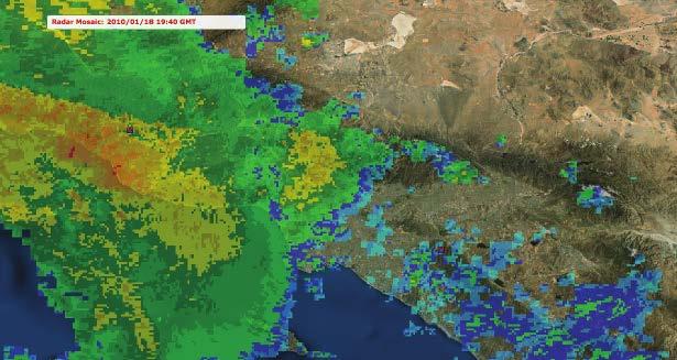
12 Old/Grand Prix Debris Flows, Dec San Gabriel San Bernardino Radar shows high reflectivity mostly confined to mountains Image: NCEI radar archive

13 Other Features: Squall line/ncfr Oakley et al Natural Hazards 13
14 Other Features: NCFR Dec : Camarillo Springs Debris Flow 14

15 Jan Montecito Debris Flow Thanks to D. Staley for making images into video Images: CNRFC

16 Summary: Southern CA In study: built catalog of PFDF events ARs present in 13/19 events Southerly low-level flow Strong upper level jet with exit over S. CA Orography plays big role, several cases additionally have NCFR/squall line Damage in Montecito following Jan debris flow 16
17 Outline: CA Post-Fire Debris Flows 1. Climatological study in Transverse Ranges 2. Observations in central/northern California 3. Post-fire debris flows in a future climate Post-fire debris flow on Springs Fire burn area 12/12/2014, Camarillo, CA

18 Squall line over Butte Fire burn area March 6, 2016 Stockton Angels Camp Mono Lake Courtesy Jeremy Lancaster, CGS
 Debris flow at Hawver Rd, North Fork Calaveras River watershed Courtesy")
19 12/3/15 (Before) Butte Fire burn area after intense rain March 6, 2016 Rain rates ~1.5 in/h 3/9/16 (After) Debris flow at Hawver Rd, North Fork Calaveras River watershed Courtesy Jeremy Lancaster, CGS


20 12/3/15 (Before) Detwiler Burn Scar: March Band of intense t-storms 3/9/16 (After) San Jose Modesto Turlock Mammoth Detwiler burn area Madera Image: CNRFC


21 12/3/15 (Before) Detwiler Burn Scar: March *Preliminary information* Sediment on roadways, many road closures, damage to several homes Rain rates up to 0.92 inches in 30 minutes observed Images: K. Mattarochia, NWS Hanford


 Courtesy")
22 History of debris flows in Big Sur SP Following Basin Complex Fire June 2008 Apr 7, 2009 Precipitation rate 0.84 in/hr (21.3 mm/hr) Courtesy Jeremy Lancaster, CGS


23 Monitoring Soberanes Burn Area (winter 2016/17) Possibility of debris flow above Pfeiffer Falls 12/29/16 01/10/17 Small debris flows in Palo Colorado Cyn, rate of ~20 mm/h for 15 min Photo: CGS

24 Why no debris flows in Soberanes? Hypotheses: Rainfall not intense enough All sediment flushed out by 2009 event Soil burn severity may not have been high enough (low-moderate) Ash movement on Palo Colorado Rd late Oct Photo: CGS

25 North Bay: No significant debris flows this winter. Why not? Nuns Fire Atlas Fire landslides.usgs.gov/hazards/postfire_debrisflow/ Hypotheses: Low to moderate severity burn Rainfall intensities not high enough? (little known about area)

26 Summary: Central/Northern CA Much less known about triggering rates Generally higher than southern CA Isolated thunderstorms, squall lines appear to dominate Limited populations on alluvial fans; smaller fans than S. CA Atlas Fire burns hills east of Napa on 9 Oct Photo: M. Short, SF Chronicle 26
27 Outline: CA Post-Fire Debris Flows 1. Climatological study in Transverse Ranges 2. Observations in central/northern California 3. Post-fire debris flows in a future climate Post-fire debris flow on Springs Fire burn area 12/12/2014, Camarillo, CA

28 California Fire in the Future Length of fire season, size of fires likely to increase Forested areas prone to more intense fires Southern CA remains ignition limited Population growth a big factor in fire frequency/impacts No consensus on lightning activity Thomas Fire smoke over 101 Freeway near Carpinteria. Photo: S. Palley/Washington Post 28

29 Future Hourly Precipitation Extremes For Dec-Jan-Feb 2-3x more likely to exceed top 0.05% hourly rainfall in warmer climate in CA in DJF Change in exceedance probability of the top 0.05% highest hourly precipitation rates observed in control period (Jan 2001-Sept 2013) Based on RCP 8.5 (high emissions) scenario Prein et al. 2017, Nature Climate Change

30 Take-home messages: Post-fire debris flows in California Antecedent rainfall not needed for debris flow in burn area Do not need big storm High intensity rainfall key Atmospheric rivers present, mesoscale features play key role Extended fire season likely in future Hourly precipitation extremes more frequent in future climate ALERT observations critical to post-fire debris flow research! Looking down on Thomas burn area, Feb 2018

31 Future Work Establish sub-daily records for CA! Process data, increase monitoring in northern/central CA Improve understanding of NCFR/squall lines in CA Evaluate weather model performance Assess changes (historic, future) in high intensity, short duration precipitation Thomas Fire Photo: Ventura OES 31


32 Western Regional Climate Center Thank you! Research supported by: @CW3E_Scripps WRCC NASA astronaut Randy Bresnik photographed the Southern California plumes of smoke on 5 Dec 2017 aboard the ISS
33 EXTRA SLIDES Post-fire debris flow on Springs Fire burn area 12/12/2014, Camarillo, CA Western Regional Climate Center Providing climate services since

34 Atmospheric Rivers Source: AMS Glossary 34


35 Event Case Studies Data Sources: NARR (32 km) SSM/I radar wind profilers precipitation gauges Sample case study: 18 Jan


36 Determining Event Timing pressure transducer Laser stage gauge + rain triggered camera wildlife camera


37 Precipitation Observations ALERT research gauges RAWS gauges radar 15 min or better real-time observations most valuable!

38 CW3E Probability of AR Conditions Western Regional Climate Center Providing climate services since
 Western Regional Climate Center Providing climate services since landslides.usgs.")
39 USGS Debris Flow Hazard Assessment The area above Montecito was evaluated as having a high likelihood of debris flow with the design storm (peak 15 min intensity of 24 mm/h rate) Western Regional Climate Center Providing climate services since landslides.usgs.gov/hazards/postfire_debrisflow/

40 CNRFC Radar Archive Western Regional Climate Center Providing climate services since

41 Jan Montecito: Low-level winds Source: CANSAC WRF
42 Future Hourly Precipitation Extremes Prein et al. 2017, Nature Climate Change

43 Decrease in Number of Precipitation Days Future period: Baseline period: Pierce et al. 2013, J. Climate
 events Change in days per year exceeding thresholds (2060-2069 minus 1985-1994) Pierce et al. 2013, J.")
44 Increase in daily precipitation totals Discrepancies on wetter/drier trend in future depends largely on changes in frequency of largest (>60 mm/day) events Change in days per year exceeding thresholds ( minus ) Pierce et al. 2013, J. Climate
Atmospheric rivers as triggers for post-fire debris flows in the Transverse Ranges of Southern California
 Atmospheric rivers as triggers for post-fire debris flows in the Transverse Ranges of Southern California International Atmospheric Rivers Conference,10 August 2016 Nina Oakley, Jeremy Lancaster, Mike
CW3E Atmospheric River Outlook
 CW3E Atmospheric River Outlook Update on Atmospheric River Forecast to Impact California Next Week - The terminus of the atmospheric river plume is approaching coastal CA and precipitation will begin today
CW3E Atmospheric River Summary
 CW3E Atmospheric River Summary A strong AR made landfall over southern California this week - The atmospheric river made initial landfall over Big Sur around 1800 UTC Wednesday, 20 March 2018 - AR conditions
CW3E Atmospheric River Update
 CW3E Atmospheric River Update Update on ARs Currently Impacting and Forecast to Impact West Coast Precipitation continues to fall over a majority of California The Transverse Mountains (north of Santa
CW3E Atmospheric River Outlook
 CW3E Atmospheric River Outlook Update on Atmospheric River Forecast to Impact California This Week - Precipitation continues to fall across portions of California - The AR will begin to propagate southward
California OES Weather Threat Briefing
 California OES Weather Threat Briefing Wednesday, January 16, 2019 9:00 AM PST Day 1: Strong winds, heavy mountain snow and heavy rain with isolated thunderstorms across much of the state through Thursday
Areal Reduction Factors for the Colorado Front Range and Analysis of the September 2013 Colorado Storm
 Areal Reduction Factors for the Colorado Front Range and Analysis of the September 2013 Colorado Storm Doug Hultstrand, Bill Kappel, Geoff Muhlestein Applied Weather Associates, LLC - Monument, Colorado
Landslide Hazards: A Stealth Threat to the Nation
 Landslide Hazards: A Stealth Threat to the Nation Sponsored by the Geological Society of America Association of Environmental & Engineering Geologists American Society of Civil Engineers In Cooperation
CW3E Atmospheric River Outlook Update on Atmospheric River Forecast to Impact California This Week - Light to moderate precipitation has begun
 CW3E Atmospheric River Outlook Update on Atmospheric River Forecast to Impact California This Week - Light to moderate precipitation has begun falling over portions of California - GFS Ensemble members
EMERGENCY WARNING SYSTEM PROCEDURES FOR DEBRIS FLOWS IN WESTERN OREGON
 EMERGENCY WARNING SYSTEM PROCEDURES FOR DEBRIS FLOWS IN WESTERN OREGON Updated: 12/03/2007 by the Oregon Department of Forestry and the Oregon Department of Geology and Mineral Industries Debris flows
Areal Reduction Factors for the Colorado Front Range and Analysis of the September 2013 Colorado Storm
 Areal Reduction Factors for the Colorado Front Range and Analysis of the September 2013 Colorado Storm Doug Hultstrand, Bill Kappel, Geoff Muhlestein Applied Weather Associates, LLC - Monument, Colorado
Tracking the Climate Of Northern Colorado Nolan Doesken State Climatologist Colorado Climate Center Colorado State University
 Tracking the Climate Of Northern Colorado Nolan Doesken State Climatologist Colorado Climate Center Colorado State University Northern Colorado Business Innovations November 20, 2013 Loveland, Colorado
Three main areas of work:
 Task 2: Climate Information 1 Task 2: Climate Information Three main areas of work: Collect historical and projected weather and climate data Conduct storm surge and wave modeling, sea-level rise (SLR)
CoCoRaHS Monitoring Colorado s s Water Resources through Community Collaborations
 CoCoRaHS Monitoring Colorado s s Water Resources through Community Collaborations Nolan Doesken Colorado Climate Center Atmospheric Science Department Colorado State University Presented at Sustaining
QPF? So it s a Land-falling Atmospheric River, Can That Help the Forecaster Make a Better. David W. Reynolds
 So it s a Land-falling Atmospheric River, Can That Help the Forecaster Make a Better QPF? David W. Reynolds Cooperative Institute for Research in Environmental Sciences Boulder, CO Brian Kawzenuk Center
Flooding in Western North Carolina: Some Spatial, Hydrologic, and Seasonal Characteristics CAUTION!! Outline. Basic Flood Facts.
 Flooding in Western North Carolina: Some Spatial, Hydrologic, and Seasonal Characteristics J. Greg Dobson CAUTION!! National Environmental Modeling and Analysis Center RENCI at UNC-Asheville Engagement
CW3E Atmospheric River Update and Outlook
 Summary by C. Hecht and F.M. Ralph 3 PM PT Thurs 19 Jan. 2017 CW3E Atmospheric River Update and Outlook Update on 3 ARs Forecast to Impact the West Coast Over Next Several Days - AR 1 made landfall over
High Resolution Numerical Weather Prediction for High Impact and Extreme Weather Events in 2014 across Southern California
 High Resolution Numerical Weather Prediction for High Impact and Extreme Weather Events in 2014 across Southern California Alex Tardy Alexander.Tardy@noaa.gov NWS San Diego Warning Coordination Meteorologist
Will a warmer world change Queensland s rainfall?
 Will a warmer world change Queensland s rainfall? Nicholas P. Klingaman National Centre for Atmospheric Science-Climate Walker Institute for Climate System Research University of Reading The Walker-QCCCE
Presentation Overview. Southwestern Climate: Past, present and future. Global Energy Balance. What is climate?
 Southwestern Climate: Past, present and future Mike Crimmins Climate Science Extension Specialist Dept. of Soil, Water, & Env. Science & Arizona Cooperative Extension The University of Arizona Presentation
CW3E Atmospheric River Outlook
 CW3E Atmospheric River Outlook For California DWR s AR Program Update on the ARs forecast to Impact California this Week - Forecast confidence within the GEFS has continued to increase for the two ARs
Severe Weather Watches, Advisories & Warnings
 Severe Weather Watches, Advisories & Warnings Tornado Watch Issued by the Storm Prediction Center when conditions are favorable for the development of severe thunderstorms and tornadoes over a larger-scale
CW3E Atmospheric River Outlook
 CW3E Atmospheric River Outlook For California DWR s AR Program Potential for Atmospheric River Activity over California Next Week - Multiple systems are currently forecasted to potentially bring AR conditions
Weather and Climate of the Rogue Valley By Gregory V. Jones, Ph.D., Southern Oregon University
 Weather and Climate of the Rogue Valley By Gregory V. Jones, Ph.D., Southern Oregon University The Rogue Valley region is one of many intermountain valley areas along the west coast of the United States.
Climate Variability and Change, and Southern California Water San Gabriel Valley Water Forum, Pomona, CA, October 2, 2014
 Climate Variability and Change, and Southern California Water San Gabriel Valley Water Forum, Pomona, CA, October 2, 2014 Dan Cayan (with Mike Dettinger, David Pierce, Suraj Polade, Mary Tyree, Alexander
Current Climate Trends and Implications
 Current Climate Trends and Implications Dr. Mark Seeley Professor emeritus Department of Soil, Water, and Climate University of Minnesota St Paul, MN 55108 Crop Insurance Conference September 12, 2018
Alluvial Fan Flooding Workshop. Barry Pierce National Weather Service, Las Vegas
 Alluvial Fan Flooding Workshop Barry Pierce National Weather Service, Las Vegas Death Valley NP, August 15, 2004 Outline National Weather Service Alluvial Fan/Flash Flooding Weather Regimes Conducive For
Caribbean Early Warning System Workshop
 Caribbean Early Warning System Workshop Hamonization in Existing EWS April 14-16, 2016 Presenter: Shawn Boyce Caribbean Institute for Meteorology and Hydrology Husbands, St. James Barbados Background Between
An EXpanded View on the Climatology of Atmospheric Rivers Impacting the Southern Appalachian Mountains
 An EXpanded View on the Climatology of Atmospheric Rivers Impacting the Southern Appalachian Mountains 2 3 Douglas Miller1, Chelcy Ford Miniat, Rick Wooten, Ana 4 1 Barros, and Kaitlyn Kelly 1 UNC Asheville
Significant Rainfall and Peak Sustained Wind Estimates For Downtown San Francisco
 Significant Rainfall and Peak Sustained Wind Estimates For Downtown San Francisco Report Prepared by John P. Monteverdi, PhD, CCM July 30, 1998 Mayacamas Weather Consultants 1. Impact of Location The location
Highlights of the 2006 Water Year in Colorado
 Highlights of the 2006 Water Year in Colorado Nolan Doesken, State Climatologist Atmospheric Science Department Colorado State University http://ccc.atmos.colostate.edu Presented to 61 st Annual Meeting
CW3E Atmospheric River Update
 CW3E Atmospheric River Update Update on ARs Currently Impacting and Forecast to Impact West Coast As much as 6.5 inches of precipitation has fallen over the high elevations of CA over the previous 48 hours
Talk Overview. Concepts. Climatology. Monitoring. Applications
 Atmospheric Rivers Talk Overview Concepts Climatology Monitoring Applications Satellite View Where is the storm? Where is the impact? Atmospheric Rivers Plume or fire hose of tropical moisture Heavy precipitation
California OES Atmospheric River Events Weather Threat Briefing
 California OES Atmospheric River Events Weather Threat Briefing 23 February 2017 10:00 AM PST Day 1: Flooding continues along small streams and creeks and some main stem rivers. National Weather Service
Forecasting Challenges
 Forecasting Challenges 2017-18 Alex Tardy- NWS San Diego Alexander.Tardy@noaa.gov CW3E meetings April 2018 Atmospheric Rivers Climate Forecast System by NOAA 100-h fuel moisture all-time low for South
Colorado weather and climate update: a bit more than halfway through the water year (Or: What s going on with the weather?? )
") Colorado weather and climate update: a bit more than halfway through the water year (Or: What s going on with the weather?? ) Russ S. Schumacher Colorado State Climatologist Director, Colorado Climate
Colorado weather and climate update: a bit more than halfway through the water year (Or: What s going on with the weather?? ) Russ S. Schumacher Colorado State Climatologist Director, Colorado Climate
Applications/Users for Improved S2S Forecasts
 Applications/Users for Improved S2S Forecasts Nolan Doesken Colorado Climate Center Colorado State University WSWC Precipitation Forecasting Workshop June 7-9, 2016 San Diego, CA First -- A short background
Crystal Moncada. California State University San Bernardino. January- July Brett R. Goforth- Department of Geography and Environmental Studies
 A Geographical Information System (GIS) Based Evaluation of Landslide Susceptibility Mapped on the Harrison Mountain Quadrangle of the Santa Ana River Watershed Crystal Moncada California State University
The Climate of Oregon Climate Zone 4 Northern Cascades
 /05 E55 Unbound issue No. 9/ is Does not circulate Special Report 916 May 1993 The Climate of Oregon Climate Zone 4 Property of OREGON STATE UNIVERSITY Library Serials Corvallis, OR 97331-4503 Agricultural
CW3E Atmospheric River Update Outlook
 CW3E Atmospheric River Update Outlook Two systems expected to produce precipitation over the U.S. West Coast in the next week - AR conditions (IVT >250 kg m -1 s -1 and IWV >20 mm) are expected over most
2015 Fall Conditions Report
 2015 Fall Conditions Report Prepared by: Hydrologic Forecast Centre Date: December 21 st, 2015 Table of Contents Table of Figures... ii EXECUTIVE SUMMARY... 1 BACKGROUND... 2 SUMMER AND FALL PRECIPITATION...
Seasonal Climate Watch November 2017 to March 2018
 Seasonal Climate Watch November 2017 to March 2018 Date issued: Oct 26, 2017 1. Overview The El Niño Southern Oscillation (ENSO) continues to develop towards a La Niña state, and is expected to be in at
El Niño Update Impacts on Florida
 Current Issues in Emergency Management (CIEM) Sessions 1 &2 October 12 th and 26 th, 2006 Florida Division of Emergency Management Tallahassee, Florida El Niño Update Impacts on Florida Bart Hagemeyer
AFAC 2006 page 536. Climate-Change Impacts on fire-weather in SE Australia Kevin Hennessy, Principal Research Scientist, CSIRO
 AFAC 2006 page 536 Climate-Change Impacts on fire-weather in SE Australia Kevin Hennessy, Principal Research Scientist, CSIRO AFAC 2006 page 537 Climate change impacts on fire-weather risk in south-east
2. PHYSICAL SETTING FINAL GROUNDWATER MANAGEMENT PLAN. 2.1 Topography. 2.2 Climate
 FINAL GROUNDWATER MANAGEMENT PLAN 2. PHYSICAL SETTING Lassen County is a topographically diverse area at the confluence of the Cascade Range, Modoc Plateau, Sierra Nevada and Basin and Range geologic provinces.
Funding provided by NOAA Sectoral Applications Research Project CLIMATE. Basic Climatology Colorado Climate Center
 Funding provided by NOAA Sectoral Applications Research Project CLIMATE Basic Climatology Colorado Climate Center Remember These? Factor 1: Our Energy Source Factor 2: Revolution & Tilt Factor 3: Rotation!
Storm and Runoff Calculation Standard Review Snowmelt and Climate Change
 Storm and Runoff Calculation Standard Review Snowmelt and Climate Change Presented by Don Moss, M.Eng., P.Eng. and Jim Hartman, P.Eng. Greenland International Consulting Ltd. Map from Google Maps TOBM
Central Asia Regional Flash Flood Guidance System 4-6 October Hydrologic Research Center A Nonprofit, Public-Benefit Corporation
 http://www.hrcwater.org Central Asia Regional Flash Flood Guidance System 4-6 October 2016 Hydrologic Research Center A Nonprofit, Public-Benefit Corporation FFGS Snow Components Snow Accumulation and
SEPTEMBER 2013 REVIEW
 Monthly Long Range Weather Commentary Issued: October 21, 2013 Steven A. Root, CCM, President/CEO sroot@weatherbank.com SEPTEMBER 2013 REVIEW Climate Highlights The Month in Review The average temperature
INVISIBLE WATER COSTS
 Every Drop Every Counts... Drop Counts... INVISIBLE WATER COSTS Corn - 108.1 gallons per pound How much water it takes to produce... Apple - 18.5 gallons to grow Beef - 1,581 gallons per pound Oats - 122.7
Climate Outlook through 2100 South Florida Ecological Services Office Vero Beach, FL January 13, 2015
 Climate Outlook through 2100 South Florida Ecological Services Office Vero Beach, FL January 13, 2015 Short Term Drought Map: Short-term (
CW3E Atmospheric River Update Outlook Strong AR forecast to impact California this weekend - A strong AR with IVT as high as 1000 kg m -1 s -1 is
 CW3E Atmospheric River Update Outlook Strong AR forecast to impact California this weekend - A strong AR with IVT as high as 1000 kg m -1 s -1 is forecast make landfall over the West Coast this Weekend
Daily Operations Briefing. Saturday, March 3, :30 a.m. EST
 Daily Operations Briefing Saturday, March 3, 2018 8:30 a.m. EST Northeast Coastal Storm Situation A high-impact and long duration coastal storm is bringing area of heavy rain and snow, significant coastal
Sierra Weather and Climate Update
 Sierra Weather and Climate Update 2014-15 Kelly Redmond Western Regional Climate Center Desert Research Institute Reno Nevada Yosemite Hydroclimate Workshop Yosemite Valley, 2015 October 8-9 Percent of
CW3E Atmospheric River Outlook Update on the Multiple ARs forecast to Impact California this Week - Forecast confidence in the onset, duration, and
 CW3E Atmospheric River Outlook Update on the Multiple ARs forecast to Impact California this Week - Forecast confidence in the onset, duration, and magnitude of AR conditions has increased since the last
The Climate of Payne County
 The Climate of Payne County Payne County is part of the Central Great Plains in the west, encompassing some of the best agricultural land in Oklahoma. Payne County is also part of the Crosstimbers in the
Gateway Trail Project
 Gateway Trail Project Debris Flow Hazard Assessment By: Juan de la Fuente April 30, 2010 Background- On April 22, 2010, the Shasta-Trinity National Forest (Mt. Shasta-McCloud Unit) requested a geologic
Projected Impacts of Climate Change in Southern California and the Western U.S.
 Projected Impacts of Climate Change in Southern California and the Western U.S. Sam Iacobellis and Dan Cayan Scripps Institution of Oceanography University of California, San Diego Sponsors: NOAA RISA
A High Elevation Climate Monitoring Network
 A High Elevation Climate Monitoring Network Kelly T. Redmond Western Regional Climate Center Desert Research Institute Reno Nevada AGU San Francisco WRCC / OSU Nevada Precip-Elevation Distribution 100%
Regional Climate Change: Current Impacts and Perspectives Greater Lake Nipissing Stewardship Council Annual Meeting Wednesday April 16, 2014
 Regional Climate Change: Current Impacts and Perspectives Greater Lake Nipissing Stewardship Council Annual Meeting Wednesday April 16, 2014 Speaker: Peter Bullock, Stantec Consulting Information Source:
Impacts of the April 2013 Mean trough over central North America
 Impacts of the April 2013 Mean trough over central North America By Richard H. Grumm National Weather Service State College, PA Abstract: The mean 500 hpa flow over North America featured a trough over
The Climate of Marshall County
 The Climate of Marshall County Marshall County is part of the Crosstimbers. This region is a transition region from the Central Great Plains to the more irregular terrain of southeastern Oklahoma. Average
The Climate of Haskell County
 The Climate of Haskell County Haskell County is part of the Hardwood Forest. The Hardwood Forest is characterized by its irregular landscape and the largest lake in Oklahoma, Lake Eufaula. Average annual
The Documentation of Extreme Hydrometeorlogical Events: Two Case Studies in Utah, Water Year 2005
 The Documentation of Extreme Hydrometeorlogical Events: Two Case Studies in Utah, Water Year 2005 Tim Bardsley1*, Mark Losleben2, Randy Julander1 1. USDA, NRCS, Snow Survey Program, Salt Lake City, Utah.
Colorado s 2003 Moisture Outlook
 Colorado s 2003 Moisture Outlook Nolan Doesken and Roger Pielke, Sr. Colorado Climate Center Prepared by Tara Green and Odie Bliss http://climate.atmos.colostate.edu How we got into this drought! Fort
THUNDERSTORMS Brett Ewing October, 2003
 THUNDERSTORMS Brett Ewing October, 2003 A natural hazard that occurs often on a daily basis in the lower and mid-latitudes is thunderstorms. Thunderstorms is a weather system that can produce lightning,tornadoes,
MULTI-AGENCY COORDINATION SYSTEM PUBLICATION CALIFORNIA FIRE WEATHER PROGRAM RISK PREPAREDNESS GUIDE MACS 410-3
 MULTI-AGENCY COORDINATION SYSTEM PUBLICATION CALIFORNIA FIRE WEATHER PROGRAM RISK PREPAREDNESS GUIDE MACS 410-3 August 26, 2013 California Fire Weather Program Risk Preparedness Guide Table of Contents
Seeley Burn Scar SR-31, Region 4 UDOT Weather Response Summer 2013
 Seeley Burn Scar SR-31, Region 4 UDOT Weather Response Summer 2013 Seeley Burn Scar Information June 26 July 18, 2012 48,050 acres burned Lightning caused fire 8 miles of SR-31 impacted Huntington Creek
What Does It Take to Get Out of Drought?
 What Does It Take to Get Out of Drought? Nolan J. Doesken Colorado Climate Center Colorado State University http://ccc.atmos.colostate.edu Presented at the Insects, Diseases and Drought Workshop, May 19,
Flood and emergency preparedness CARNATION DUVALL CITIZEN CORPS DUVALL KING COUNTY FIRE DISTRICT 45 SEPTEMBER 11, 2018
 Flood and emergency preparedness CARNATION DUVALL CITIZEN CORPS DUVALL KING COUNTY FIRE DISTRICT 45 SEPTEMBER 11, 2018 Let s get started Important info! Presenters Kathy Brasch, Carnation-Duvall Citizen
What is happening to the Jamaican climate?
 What is happening to the Jamaican climate? Climate Change and Jamaica: Why worry? Climate Studies Group, Mona (CSGM) Department of Physics University of the West Indies, Mona Part 1 RAIN A FALL, BUT DUTTY
Technical Notes: Magnitude and Return Period of 2004 Hurricane Rainfall in Florida
 Journal of Floodplain Management Floodplain Management Association NOV. 2005 Vol. 5, No. 1 Glenn Tootle 1 Thomas Mirti 2 Thomas Piechota 3 Technical Notes: Magnitude and Return Period of 2004 Hurricane
Climate of Columbus. Aaron Wilson. Byrd Polar & Climate Research Center State Climate Office of Ohio.
 Climate of Columbus Aaron Wilson Byrd Polar & Climate Research Center http://bpcrc.osu.edu/greenteam Overview Historical Climatology Climate Change & Impacts Projected Changes Summary 2 Historical Climatology
Climate Outlook through 2100 South Florida Ecological Services Office Vero Beach, FL September 9, 2014
 Climate Outlook through 2100 South Florida Ecological Services Office Vero Beach, FL September 9, 2014 Short Term Drought Map: Short-term (
Chiang Rai Province CC Threat overview AAS1109 Mekong ARCC
 Chiang Rai Province CC Threat overview AAS1109 Mekong ARCC This threat overview relies on projections of future climate change in the Mekong Basin for the period 2045-2069 compared to a baseline of 1980-2005.
2003 Moisture Outlook
 2003 Moisture Outlook Nolan Doesken and Roger Pielke, Sr. Colorado Climate Center Prepared by Tara Green and Odie Bliss http://climate.atmos.colostate.edu Through 1999 Through 1999 Fort Collins Total Water
A Preliminary Severe Winter Storms Climatology for Missouri from
 A Preliminary Severe Winter Storms Climatology for Missouri from 1960-2010 K.L. Crandall and P.S Market University of Missouri Department of Soil, Environmental and Atmospheric Sciences Introduction The
US/Global Natural Catastrophe Update
 US/Global Natural Catastrophe Update NAIC's CIPR Symposium on Implications of Increasing Catastrophe Volatility on Insurers Carl Hedde, SVP, Head of Risk Accumulation Munich Reinsurance America, Inc. Source:
DEPARTMENT OF EARTH & CLIMATE SCIENCES Name SAN FRANCISCO STATE UNIVERSITY Nov 29, ERTH 360 Test #2 200 pts
 DEPARTMENT OF EARTH & CLIMATE SCIENCES Name SAN FRANCISCO STATE UNIVERSITY Nov 29, 2018 ERTH 360 Test #2 200 pts Each question is worth 4 points. Indicate your BEST CHOICE for each question on the Scantron
Changing Hydrology under a Changing Climate for a Coastal Plain Watershed
 Changing Hydrology under a Changing Climate for a Coastal Plain Watershed David Bosch USDA-ARS, Tifton, GA Jeff Arnold ARS Temple, TX and Peter Allen Baylor University, TX SEWRU Objectives 1. Project changes
Location Option Details. 1. Florida
 1. Florida Florida has the smallest number of earthquaes in the United States. Florida is the U.S. location where hurricanes are most frequent. Of the six deadliest hurricanes to hit the continental U.S.,
Kentucky Weather Hazards: What is Your Risk?
 Kentucky Weather Hazards: What is Your Risk? Stuart A. Foster State Climatologist for Kentucky 2010 Kentucky Weather Conference Bowling Green, Kentucky January 16, 2010 Perspectives on Kentucky s Climate
"STUDY ON THE VARIABILITY OF SOUTHWEST MONSOON RAINFALL AND TROPICAL CYCLONES FOR "
 "STUDY ON THE VARIABILITY OF SOUTHWEST MONSOON RAINFALL AND TROPICAL CYCLONES FOR 2001 2010" ESPERANZA O. CAYANAN, Ph.D. Chief, Climatology & Agrometeorology R & D Section Philippine Atmospheric Geophysical
Minnesota s Climatic Conditions, Outlook, and Impacts on Agriculture. Today. 1. The weather and climate of 2017 to date
 Minnesota s Climatic Conditions, Outlook, and Impacts on Agriculture Kenny Blumenfeld, State Climatology Office Crop Insurance Conference, Sep 13, 2017 Today 1. The weather and climate of 2017 to date
SOUTH MOUNTAIN WEATHER STATION: REPORT FOR QUARTER 2 (APRIL JUNE) 2011
 2011") SOUTH MOUNTAIN WEATHER STATION: REPORT FOR QUARTER 2 (APRIL JUNE) 2011 Prepared for ESTANCIA BASIN WATERSHED HEALTH, RESTORATION AND MONITORING STEERING COMMITTEE c/o CLAUNCH-PINTO SOIL AND WATER CONSERVATION
SOUTH MOUNTAIN WEATHER STATION: REPORT FOR QUARTER 2 (APRIL JUNE) 2011 Prepared for ESTANCIA BASIN WATERSHED HEALTH, RESTORATION AND MONITORING STEERING COMMITTEE c/o CLAUNCH-PINTO SOIL AND WATER CONSERVATION
CW3E Atmospheric River Outlook
 CW3E Atmospheric River Outlook For California DWR s AR Program Multiple ARs Forecast to impact the USWC in the coming Week - A shift into an active flow pattern may result in the landfall of successive
REDWOOD VALLEY SUBAREA
 Independent Science Review Panel Conceptual Model of Watershed Hydrology, Surface Water and Groundwater Interactions and Stream Ecology for the Russian River Watershed Appendices A-1 APPENDIX A A-2 REDWOOD
A Synoptic Climatology of Heavy Precipitation Events in California
 A Synoptic Climatology of Heavy Precipitation Events in California Alan Haynes Hydrometeorological Analysis and Support (HAS) Forecaster National Weather Service California-Nevada River Forecast Center
January 25, Summary
 January 25, 2013 Summary Precipitation since the December 17, 2012, Drought Update has been slightly below average in parts of central and northern Illinois and above average in southern Illinois. Soil
Climate change projections for Ontario: an updated synthesis for policymakers and planners
 Ministry of Natural Resources and Forestry Climate change projections for Ontario: an updated synthesis for policymakers and planners Shannon Fera and Adam Hogg Ontario Ministry of Natural Resources and
CW3E Atmospheric River Outlook
 CW3E Atmospheric River Outlook For California DWR s AR Program Update on the ARs Currently Impacting and Forecast to Impact the U.S. West Coast - Precip. has begun in association with AR 1, where as much
Bill Kappel. Doug Hultstrand. Applied Weather Associates
 Cool-Season PMP/PMF Meteorological Time Series for Snow Melt Calculations Bill Kappel Senior Meteorologist/Vice President Doug Hultstrand Hydrometeorologist Applied Weather Associates www.appliedweatherassociates.com
Table of Contents. Page
 Eighteen Years (1990 2007) of Climatological Data on NMSU s Corona Range and Livestock Research Center Research Report 761 L. Allen Torell, Kirk C. McDaniel, Shad Cox, Suman Majumdar 1 Agricultural Experiment
Heavy Rainfall Event of June 2013
 Heavy Rainfall Event of 10-11 June 2013 By Richard H. Grumm National Weather Service State College, PA 1. Overview A 500 hpa short-wave moved over the eastern United States (Fig. 1) brought a surge of
The Climate of Bryan County
 The Climate of Bryan County Bryan County is part of the Crosstimbers throughout most of the county. The extreme eastern portions of Bryan County are part of the Cypress Swamp and Forest. Average annual
The Climate of Murray County
 The Climate of Murray County Murray County is part of the Crosstimbers. This region is a transition between prairies and the mountains of southeastern Oklahoma. Average annual precipitation ranges from
Monthly Long Range Weather Commentary Issued: APRIL 18, 2017 Steven A. Root, CCM, Chief Analytics Officer, Sr. VP,
 Monthly Long Range Weather Commentary Issued: APRIL 18, 2017 Steven A. Root, CCM, Chief Analytics Officer, Sr. VP, sroot@weatherbank.com MARCH 2017 Climate Highlights The Month in Review The average contiguous
CW3E Atmospheric River Update
 CW3E Atmospheric River Update Update on AR Currently Impacting CA, OR, and WA Precipitation continues to fall over portions of Northern California, Washington, and Oregon 6 10 inches of precipitation has
The Climate of Texas County
 The Climate of Texas County Texas County is part of the Western High Plains in the north and west and the Southwestern Tablelands in the east. The Western High Plains are characterized by abundant cropland
Daily Operations Briefing. Tuesday, January 9, :30 a.m. EST
 Daily Operations Briefing Tuesday, January 9, 2018 8:30 a.m. EST Significant Activity Jan 8-9 Significant Events: Flash Flooding CA Tropical Activity: None Significant Weather: Heavy rain and Thunderstorms