Gateway Trail Project
|
|
|
- Brett Stone
- 6 years ago
- Views:
Transcription
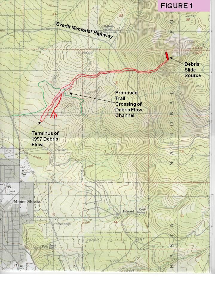
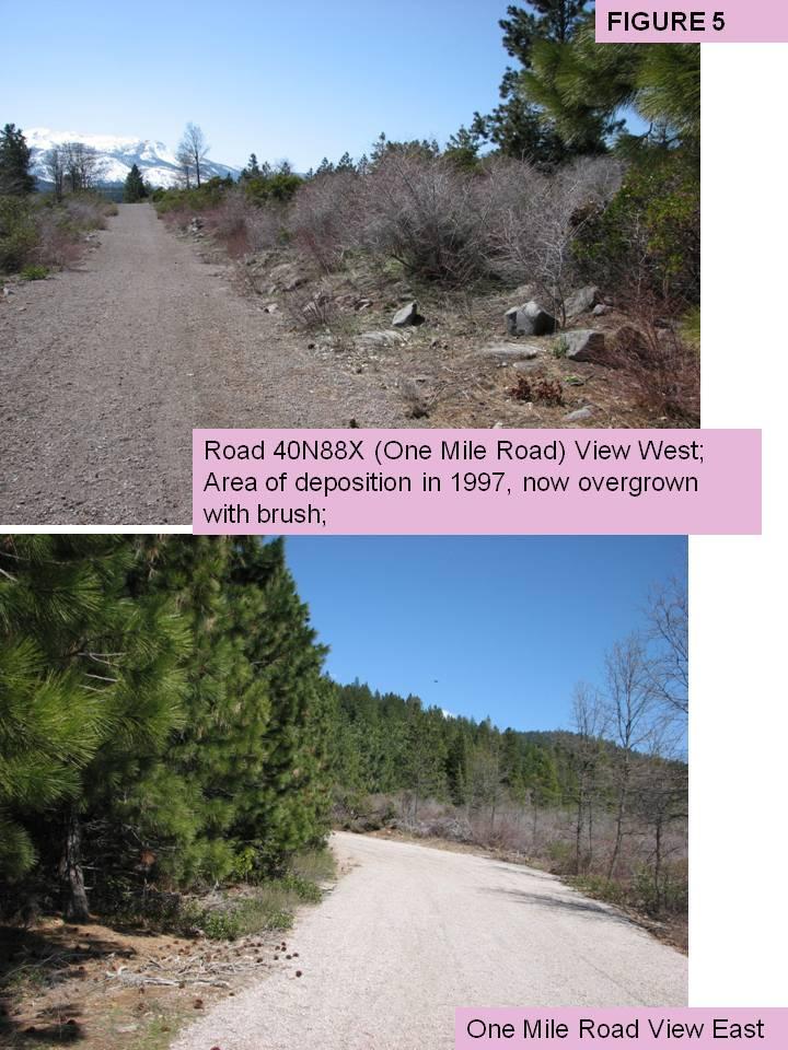
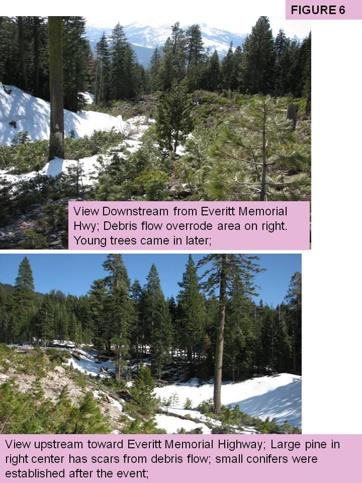
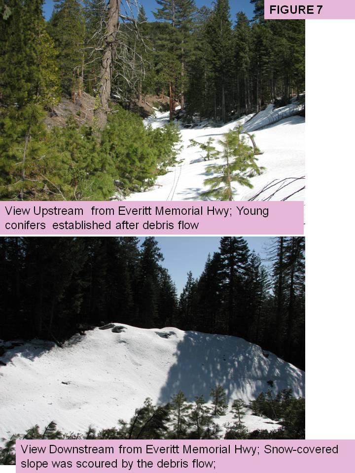
1 Gateway Trail Project Debris Flow Hazard Assessment By: Juan de la Fuente April 30, 2010 Background- On April 22, 2010, the Shasta-Trinity National Forest (Mt. Shasta-McCloud Unit) requested a geologic assessment of the debris flow hazard associated with a trail proposed for construction by the Gateway Trail Project. The segment in question is about one mile SW of McBride Springs Campground in SE ¼ of Section 3 (Figure 1). Refer to the soils and hydrology reports in the project files for additional background information. Debris flows are sediment laden flows which can travel rapidly down channels, and are capable of carrying large boulders at relatively low gradients (10% or lower). As a result, they can be very destructive to channels and infrastructure. They are often triggered by debris slides, which are shallow, rapidly moving landslides. Debris flow hazards are present around the entire perimeter of Mt Shasta Volcano, primarily in channelized upper slope positions, and also on alluvial fans below. In this setting, they can be initiated by: a) Sustained warm winter rains on a snowpack (such as occurred in January, 1997); b) Intense convective summer storms; c) High summer temperatures which cause rapid glacial melt; d) Volcanic eruptions which melt snow and ice. The hazard associated with volcanic eruption in the project area has been classified as Intermediate potential hazard from mudflows associated with eruptions (Miller, 1980). The terms mudflow and debris flow are used synonymously in this report. Purpose- The purpose of this investigation was to assess the debris flow hazard to trail users at the Proposed Trail Crossing of Debris Flow Crossing in Figure 1. This channel carried a large debris flow during the flood of January, Methods- Field- On April 23, 2010, a field visit was made by Juan de la Fuente and Steve Bachmann. It included visits to the southern half of Section 3 ( Terminus of 1997 Debris Flow, Figure 1) adjacent to Road 40N88X (One Mile Road), and to the SW ¼ of Section 2, where the Everitt Memorial Highway crosses the debris flow channel. The area near Everitt Memorial Highway had substantial snow cover, but the lower site was mostly free of snow. We did not visit the actual site where the trail would cross the debris flow track due to the snow cover. We plan to visit the site with Recreation personnel when the snow is gone. We also discussed field observations Steve had made immediately after the debris flow in 1997.
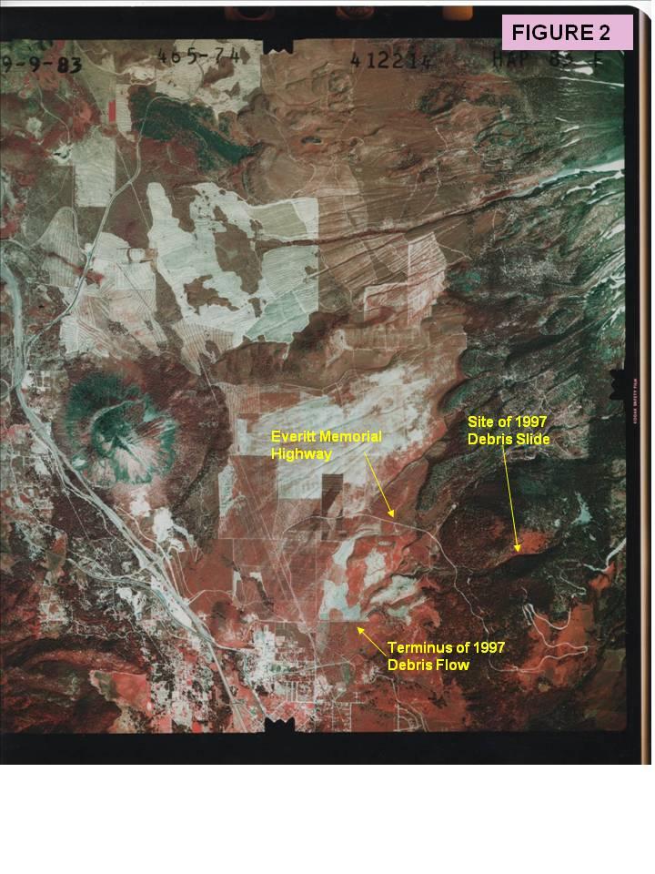
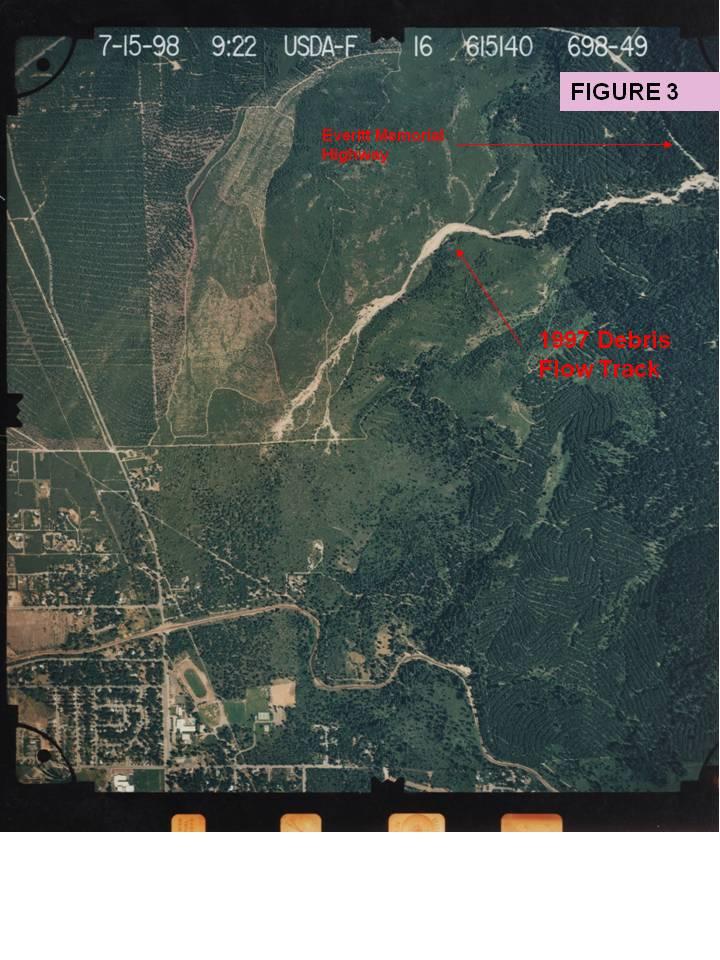
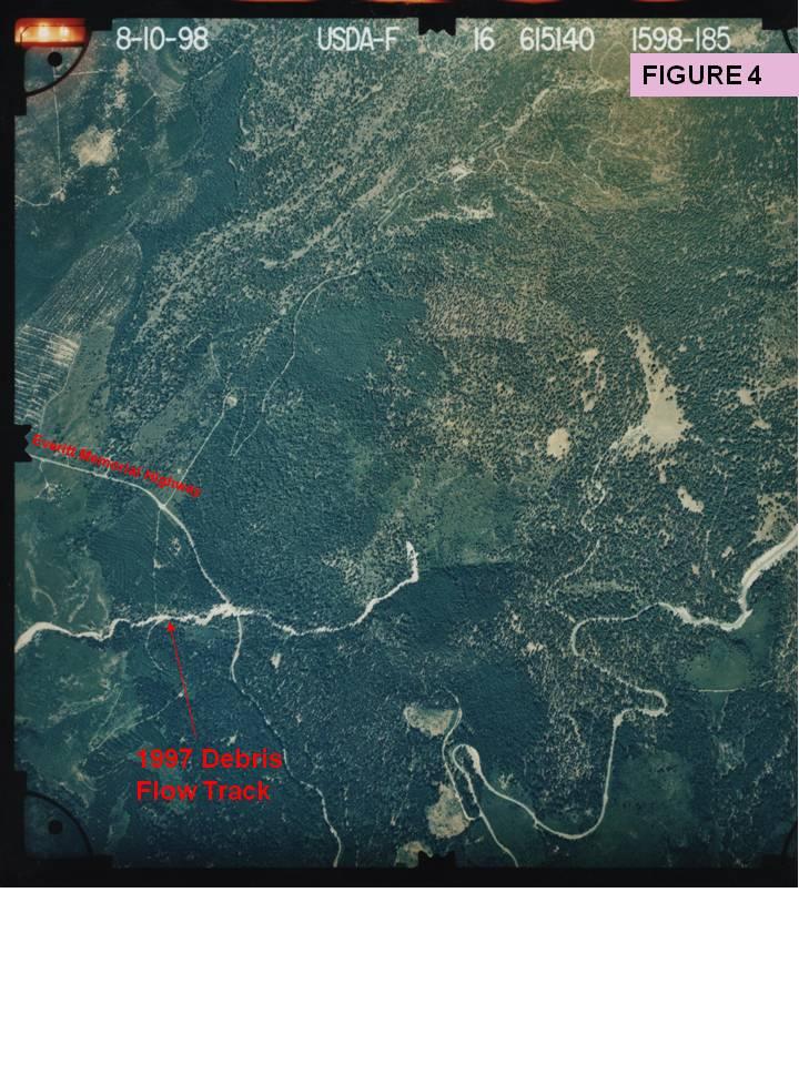
2 Review of Documents & Maps- The Mount Shasta Gateway Trail Recreational Trails Program Proposal, and associated hydrology report were reviewed. S.O. Geology files were searched, but no information was found regarding the 1997 debris flow. Air Photo Review- Resource air photos: The following air photos were reviewed. One flight was before the 1997 debris flow, and the other was after it: Color, Scale 1:16,000 USDA-F , numbers 698-(48-49) and 1598-( ) flown ; Color Infrared Scale 1:58,000 HAP 83 F (74-76) flown on ; Findings Debris Flow- The 1997 debris flow was initiated by a shallow debris slide (shallow, rapidly moving landslide) at an approximate elevation of 6000 feet (Figure 1). This elevation coincides with the zone (4,000-6,000 feet) which experienced the highest concentrations of landslides during the 1997 flood in nearby areas (USFS 1998, page 31). Examination of post-flood 1998 air photos (Figure 4) reveals a number of large conifers still standing within the raw debris slide scar. This suggests that the slide was very shallow, with the deepest part near the top, and debris probably overrode natural ground in the lower 2/3 of the slide, and thereby allowed the trees to survive. The debris slide is about 170 feet wide and 700 feet long. When the debris slide entered the stream below, it initiated a debris flow which traveled rapidly downslope. In several locations, it left the channel as it went around bends, such as at Everitt Memorial Highway, and at its confluence with Cascade Gulch below the highway (Figure 1). In these areas, it cleared all vegetation in a swath up to 300 feet wide (Figures 2, 3). This suggests that the debris flow likely attained velocities of at least 20 miles per hour, and possibly much higher. Slope gradients at the terminus of the 1997 deposit were measured in the field at about 8%. The gradient of the channel, at the base of the debris slide is about 25%, and the gradient of the debris slide itself is about 80% (from USGS 7 ½ minute topographic map). Other Channels- This investigation focused on the unnamed channel which experienced a debris flow in However, it should be noted that all channels on the flanks of Mount Shasta, such as Cascade Gulch, Avalanche Gulch and Diller Canyon also experience periodic debris flows. Hazard to Trail Users- The frequency of debris flows in the channel crossed by the trail is likely on the order of once in a hundred years, or possibly longer. The most likely trigger would be a sustained warm winter storm preceded by an unusually wet rainy season (such as 1997) during the winter or spring. A summer convective storm could also trigger such an event. Once initiated, a debris flow similar in size to the 1997 event would likely behave in a similar way, and travel at a speed of miles per hour in upper channel reaches, slowing to a few miles per hour where the fan gradient lowers to 8%. Debris flows of this type can often be heard before they reach lower reaches, providing some warning. However, other factors, such as wind can obscure the sound. Few if any people would be on the trail in winter or spring. A debris flow triggered by a summer convective storm would have the highest potential for affecting trail users. A small event of this type was reported in this channel in the summer of 2003
3 (Steve Bachmann, personal communication ). This storm mobilized sand and gravel but had minor channel effects compared to the debris flow of It was part of a series of storms in July and August, 2003 which affected channels from Mt. Eddy through Mt Shasta, to Haight Mountain (Miller et. al, 2004). As a means of providing context, the Everitt Memorial Highway already exposes more people to debris flows at this channel than would the trail. Recommendations- Trail Design- During actual trail layout and design, the crossing of the 1997 debris flow channel should be examined more closely for geologic considerations to see if any specific design measures are needed to prevent diversion of a future debris flow. Debris Flow Frequency Historical air photos (1944 to Present) should be examined for this area to provide a better understanding for debris flow frequency on the SW flank of Mt Shasta. This information would be of great value in future project work in this area. Public Awareness- Public awareness of debris flow hazards on the flanks of Mt Shasta should be emphasized. Important points to convey are that debris flows in this setting typically occur under the following conditions: 1. Sustained warm winter storms following above average precipitation; 2. Intense convective storms; 3. Sustained high summer temperatures in streams fed by glaciers; 4. Volcanic Eruptions. Also, when faced with an imminent debris flow in a field setting, the best action to take is to avoid channels and alluvial fans (particular the heads of fans), and to move to higher ground. Discussion Snow cover prevented a close field examination of the trail crossing on the debris flow channel. However, this does not detract from the assessment of debris flow hazard addressed by this investigation because the source of this hazard is a considerable distance upslope. Future debris flows would most likely originate from the steep canyon walls above the Everitt Memorial Highway. The main issue to address at the trail crossing site is to assure that trail design and construction is done in a way to prevent any diversion of a future debris flow. The most likely trigger for a debris flow in the same channel affected by the 1997 event would be a sustained warm winter storm during an overall wet year. The steep gorge near the initiation site of the 1997 event could produce a similar debris slide in a winter storm of similar magnitude in the future. The 1997 flood has been classified as a year return interval storm, but the recurrence interval of the 1997 debris flow was probably longer than that (>100 years?). This estimate is based on the observation that the 1997 debris flow stripped many large conifers (>100 years old) from the floodplain (compare Figure 2 to Figures 3 & 4. This debris flow recurrence interval could be refined by examining
4 historical air photos back to 1944 and tracking disturbances in the channel and changes in vegetation over time. A debris flow caused by rapid summer melt of a glacier, such as at Whitney Creek in 1997 (de la Fuente and Bachmann, 1999) could not occur in this channel because it lacks a glacier directly upslope. A convective summer storm could generate a debris flow, but no large events of this type (other than a much smaller runoff event in summer 2003) have been identified historically in this channel (Steve Bachmann, Personal Communication, ). Lastly, there is always a potential for a debris flow triggered by a volcanic eruption (snowmelt), but this potential is also relatively low. On average, Mt Shasta has erupted once per 600 years over the past 4,500 years, and a small eruption occurred 200 years ago (Miller, 1980). While precise predictions are not possible, this historical information suggests that the interval between eruptions is likely to be on the order of several hundred years. Atachments- Maps, Air Photos, and Photographs are included in a separate electronic file. References- de la Fuente, Juan, Bachmann, Steve Whitney Creek Debris Flow of August 20, 1997: Triggering Mechanisms, Transport Processes, and Debris Sources. In: National Association of Geoscience Teachers Far Western Section Fall Field Conference September 17-19, Miller, Alisha, Tannaci, Tuli, de la Fuente, Juan, Jasso, Abel, and Bachmann, Steve Geomorphic and Hydrologic Effects of High-Elevation Summer Storm Events. In: Advancing the Fundamental Sciences Proceedings of the Forest Service National Earth Sciences Conference, San Diego, CA, October, 2004 (Vol. 2, page 559). Miller, C. Dan, Potential Hazards from Future Eruptions in the vicinity fo Mount Shasta Volcano, Northern California. Geological Survey Bulletin 1503 (pages & Plate 3). USFS The Flood of 1997, Klamath National Forest Phase 1 Report. Internal USFS Document by Juan de la Fuente and Don Elder (pages 13-14).
5
6
7
8
9
10
11
Mass Wasting: The Work of Gravity
 Chapter 15 Lecture Earth: An Introduction to Physical Geology Twelfth Edition Mass Wasting: The Work of Gravity Tarbuck and Lutgens Chapter 15 Mass Wasting The Importance of Mass Wasting Slopes are the
Debris Avalanches. Debris avalanche deposits on a volcano in Chile. All of the area in the foreground is buried by a thick debris avalanche.
 Debris Avalanches Volcanoes are not very stable structures. From time to time, they collapse producing large rock and ash avalanches that travel at high speeds down valleys. Collapse maybe caused by an
The last three sections of the main body of this report consist of:
 Threatened and Endangered Species Geological Hazards Floodplains Cultural Resources Hazardous Materials A Cost Analysis section that provides comparative conceptual-level costs follows the Environmental
3/3/2013. The hydro cycle water returns from the sea. All "toilet to tap." Introduction to Environmental Geology, 5e
 Introduction to Environmental Geology, 5e Running Water: summary in haiku form Edward A. Keller Chapter 9 Rivers and Flooding Lecture Presentation prepared by X. Mara Chen, Salisbury University The hydro
3.12 Geology and Topography Affected Environment
 3 Affected Environment and Environmental Consequences 3.12 Geology and Topography 3.12.1 Affected Environment 3.12.1.1 Earthquakes Sterling Highway MP 45 60 Project Draft SEIS The Kenai Peninsula is predisposed
Mass Wasting. Revisit: Erosion, Transportation, and Deposition
 Mass Wasting Revisit: Erosion, Transportation, and Deposition While landslides are a normal part of erosion and surface processes, they can be very destructive to life and property! - Mass wasting: downslope
Which map shows the stream drainage pattern that most likely formed on the surface of this volcano? A) B)
 B)") 1. When snow cover on the land melts, the water will most likely become surface runoff if the land surface is A) frozen B) porous C) grass covered D) unconsolidated gravel Base your answers to questions
1. When snow cover on the land melts, the water will most likely become surface runoff if the land surface is A) frozen B) porous C) grass covered D) unconsolidated gravel Base your answers to questions
Flooding in Western North Carolina: Some Spatial, Hydrologic, and Seasonal Characteristics CAUTION!! Outline. Basic Flood Facts.
 Flooding in Western North Carolina: Some Spatial, Hydrologic, and Seasonal Characteristics J. Greg Dobson CAUTION!! National Environmental Modeling and Analysis Center RENCI at UNC-Asheville Engagement
River Response. Sediment Water Wood. Confinement. Bank material. Channel morphology. Valley slope. Riparian vegetation.
 River Response River Response Sediment Water Wood Confinement Valley slope Channel morphology Bank material Flow obstructions Riparian vegetation climate catchment vegetation hydrological regime channel
Unit 7.2 W.E.D. & Topography Test
 Name: Score: Unit 7.2 W.E.D. & Topography Test 1. 2. 3. 4. 5. 6. 7. 8. 9. 10. 11. 12. 13. 14. 15. 16. 17. 18. 19. 20. 21. 22. 23. 24. 25. 1. The formation of mountains is due mainly to while the destruction
DETAILED DESCRIPTION OF STREAM CONDITIONS AND HABITAT TYPES IN REACH 4, REACH 5 AND REACH 6.
 DETAILED DESCRIPTION OF STREAM CONDITIONS AND HABITAT TYPES IN REACH 4, REACH 5 AND REACH 6. The Eklutna River was divided into study reaches (figure 1) prior to this site visit. Prominent geologic or
Debris flow: categories, characteristics, hazard assessment, mitigation measures. Hariklia D. SKILODIMOU, George D. BATHRELLOS
 Debris flow: categories, characteristics, hazard assessment, mitigation measures Hariklia D. SKILODIMOU, George D. BATHRELLOS Natural hazards: physical phenomena, active in geological time capable of producing
The Importance of Mass Wasting
 Mass Wasting: The Work of Gravity Earth Chapter 15 Chapter 15 Mass Wasting The Importance of Mass Wasting Slopes are the most common elements in our physical landscape Slopes may appear to be stable, but
Orting Community College Proposal
 Orting Community College Proposal Cedric, Celina, Francine, Sarah, Samuel GEO CORP Located in Washington, 42 miles south of Seattle. Situated between two rivers on fertile plains. Built on lahar deposits.
GEOL 1121 Earth Processes and Environments
 GEOL 1121 Earth Processes and Environments Wondwosen Seyoum Department of Geology University of Georgia e-mail: seyoum@uga.edu G/G Bldg., Rm. No. 122 Seyoum, 2015 Chapter 6 Streams and Flooding Seyoum,
GEOLOGY 285: INTRO. PETROLOGY
 Dr. Helen Lang Dept. of Geology & Geography West Virginia University FALL 2005 GEOLOGY 285: INTRO. PETROLOGY Mount St. Helens 1980 Eruption Small earthquakes Small steam and ash eruptions in March and
Mt St Helens was know to have entered into active periods that lasted from years once every years over the last 500 years, (Figure 5).
.") Lecture #8 notes; Geology 3950, Spring 2006; CR Stern May 1980 eruption of Mt St Helens volcano (text pages 183-192 in the 4 th edition and 206-222 in the 5 th edition) Mt St Helens in southwest Washington
Lecture #8 notes; Geology 3950, Spring 2006; CR Stern May 1980 eruption of Mt St Helens volcano (text pages 183-192 in the 4 th edition and 206-222 in the 5 th edition) Mt St Helens in southwest Washington
The Documentation of Extreme Hydrometeorlogical Events: Two Case Studies in Utah, Water Year 2005
 The Documentation of Extreme Hydrometeorlogical Events: Two Case Studies in Utah, Water Year 2005 Tim Bardsley1*, Mark Losleben2, Randy Julander1 1. USDA, NRCS, Snow Survey Program, Salt Lake City, Utah.
Why was this eruption important?
 Mount St. Helens Mount St. Helens has a long geological history (>3,000 yrs) of explosive eruptions. The 1980 Events: Initial relatively mild steam and ash (Vulcanian) eruptions. Sustained plinian eruption
Water, geology, climate & soils: Sierra Nevada, Merced River & Central Valley connections
 Water, geology, climate & soils: Sierra Nevada, Merced River & Central Valley connections Geography & geology Merced River basin Climate & hydrology Soils & soil formation Roger Bales UC Merced Water,
Ch. 8: Mass Movements, Wind and Glaciers
 Ch. 8: Mass Movements, Wind and Glaciers Every day the landscape around us undergoes changes. Changes that are powered by gravity alone are called mass movement or mass wasting. Mass movement includes
Your web browser (Safari 7) is out of date. For more security, comfort and the best experience on this site: Update your browser Ignore
 is out of date. For more security, comfort and the best experience on this site: Update your browser Ignore") Your web browser (Safari 7) is out of date. For more security, comfort and the best experience on this site: Update your browser Ignore ALLU VIAL FAN colluvial fan, debris cone For the complete encyclopedic
Your web browser (Safari 7) is out of date. For more security, comfort and the best experience on this site: Update your browser Ignore ALLU VIAL FAN colluvial fan, debris cone For the complete encyclopedic
Module/Unit: Landforms Grade Level: Fifth
 Module/Unit: Landforms Grade Level: Fifth PA Academic Standards for Science and Technology and Environment and Ecology: 3.1.7.B Describe the use of models as an application or scientific or technological
Flood Risk Assessment
 Flood Risk Assessment February 14, 2008 Larry Schick Army Corps of Engineers Seattle District Meteorologist General Assessment As promised, La Nina caused an active winter with above to much above normal
Norse Peak and American Fire BAER Burned Area Emergency Response (BAER) Norse Peak and American Fires. Geology: Landslides
 Norse Peak and American Fires. Geology: Landslides") Burned Area Emergency Response (BAER) Norse Peak and American Fires : Landslides Snoqualmie Ranger District - Mount Baker-Snoqualmie National Forest, Washington Naches Ranger District - Okanogan-Wenatchee
Burned Area Emergency Response (BAER) Norse Peak and American Fires : Landslides Snoqualmie Ranger District - Mount Baker-Snoqualmie National Forest, Washington Naches Ranger District - Okanogan-Wenatchee
SCHUSTER SLOPE LANDSCAPE MANAGEMENT PLAN. January 15, 2015
 SCHUSTER SLOPE LANDSCAPE MANAGEMENT PLAN January 15, 2015 1 WHY DO WE NEED A LANDSCAPE MANAGEMENT PLAN? 2 PROCESS FOR DEVELOPING THE SCHUSTER SLOPE LANDSCAPE MANAGEMENT PLAN 3 NORTH DOWNTOWN SUB AREA PLAN
Reading Material. See class website. Sediments, from Oceanography M.G. Gross, Prentice-Hall
 Reading Material See class website Sediments, from Oceanography M.G. Gross, Prentice-Hall Materials filling ocean basins Dissolved chemicals especially from rivers and mid-ocean ridges (volcanic eruptions)
MINISTRY OF FORESTS, LANDS AND NATURAL RESOURCE OPERATIONS, POST-WILDFIRE RISK ANALYSIS PRELIMINARY REPORT
 MINISTRY OF FORESTS, ANDS AND NATURA RESOURCE OPERATIONS, POST-WIDFIRE RISK ANAYSIS PREIMINARY REPORT NOTE: The results given on this form are preliminary in nature and are intended to be a warning of
Mass Wasting. Mass Wasting. Earth s s External Processes
 1 Mass Wasting Presentation Modified from Instructor Resource Center on CD-ROM, Foundations of Earth Science, 4 th Edition, Lutgens & Tarbuck Mass Wasting 2 Down-slope movement of rock, loose material
Great Lakes Update. Volume 199: 2017 Annual Summary. Background
 Great Lakes Update Volume 199: 2017 Annual Summary Background The U.S. Army Corps of Engineers (USACE) tracks and forecasts the water levels of each of the Great Lakes. This report is primarily focused
Mount St. Helens. Copyright 2010 LessonSnips
 Mount St. Helens Washington State is home to the Cascade Mountains, a range of mountains that extends from the Canadian province of British Columbia to northern California. Many of these mountains are
Chapter 7 Mudflow Analysis
 Chapter 7 Mudflow Analysis 7.0 Introduction This chapter provides information on the potential and magnitude of mud floods and mudflows that may develop in Aspen due to rainfall events, snowmelt, or rain
STREAM SYSTEMS and FLOODS
 STREAM SYSTEMS and FLOODS The Hydrologic Cycle Precipitation Evaporation Infiltration Runoff Transpiration Earth s Water and the Hydrologic Cycle The Hydrologic Cycle The Hydrologic Cycle Oceans not filling
Precipitation Evaporation Infiltration Earth s Water and the Hydrologic Cycle. Runoff Transpiration
 STREAM SYSTEMS and FLOODS The Hydrologic Cycle Precipitation Evaporation Infiltration Earth s Water and the Hydrologic Cycle Runoff Transpiration The Hydrologic Cycle The Hydrologic Cycle Oceans not filling
APPENDIX E. GEOMORPHOLOGICAL MONTORING REPORT Prepared by Steve Vrooman, Keystone Restoration Ecology September 2013
 APPENDIX E GEOMORPHOLOGICAL MONTORING REPORT Prepared by Steve Vrooman, Keystone Restoration Ecology September 2 Introduction Keystone Restoration Ecology (KRE) conducted geomorphological monitoring in
Landslides and Ground Water Permeability with Respect to the. Contact Point of Glacial Lake Vermont and the Champlain Sea
 Landslides and Ground Water Permeability with Respect to the Contact Point of Glacial Lake Vermont and the Champlain Sea Sediments at Town Line Brook, Winooski, VT Michala Peabody Lara Vowles Abstract:
What is weathering and how does it change Earth s surface? Answer the question using
 7 th Grade Lesson What is weathering and how does it change Earth s surface? Answer the question using the sentence frame. You have 4 minutes. Weathering is. This changes the Earth s surface because. 1
Location Option Details. 1. Florida
 1. Florida Florida has the smallest number of earthquaes in the United States. Florida is the U.S. location where hurricanes are most frequent. Of the six deadliest hurricanes to hit the continental U.S.,
2. PHYSICAL SETTING FINAL GROUNDWATER MANAGEMENT PLAN. 2.1 Topography. 2.2 Climate
 FINAL GROUNDWATER MANAGEMENT PLAN 2. PHYSICAL SETTING Lassen County is a topographically diverse area at the confluence of the Cascade Range, Modoc Plateau, Sierra Nevada and Basin and Range geologic provinces.
August 14, James Bolton 312 Perry Lane Lovingston, VA
 August 14, 2017 James Bolton 312 Perry Lane Lovingston, VA 22949 jrbolton035@gmail.com Department of Environmental Quality Office of Wetlands & Stream Protection P.O. Box 1105 Richmond, VA 23218 comment-acp@deq.virginia.gov
Chapter 7 Mudflow Analysis
 Chapter 7 Mudflow Analysis 7.0 Introduction This chapter provides information on the potential and magnitude of mud floods and mudflows that may develop in Aspen due to rainfall events, snowmelt, or rain
Objectives. Introduction to Soils. Terms to know: What is soil? Study of Soils. The Soil Body 11/9/2012
 Objectives Explain what soil is and where it comes from Define a soil body List examples of the five soil-forming factors Explain how soils develop Introduction to Soils Terms to know: What is soil? Alluvial
Multi Hazard Evaluation of a High Voltage Transmission Network. John Eidinger 1 and Leon Kempner 2
 Multi Hazard Evaluation of a High Voltage Transmission Network John Eidinger 1 and Leon Kempner 2 1 G&E Engineering Systems Inc., P. O. Box 3592 Olympic Valley, CA 96146-3592; eidinger@earthlink.net. 2
Southern Sierra Critical Zone Observatory (CZO): hydrochemical characteristics, science & measurement strategy
: hydrochemical characteristics, science & measurement strategy") Southern Sierra Critical Zone Observatory (CZO): hydrochemical characteristics, science & measurement strategy R. Bales, C. Hunsaker, M. Conklin, J. Kirchner, B. Boyer, P. Kirchner underlying hypothesis:
Southern Sierra Critical Zone Observatory (CZO): hydrochemical characteristics, science & measurement strategy R. Bales, C. Hunsaker, M. Conklin, J. Kirchner, B. Boyer, P. Kirchner underlying hypothesis:
THE RECURRENCE INTERVAL
 Floods GEOG 366 THE RECURRENCE INTERVAL How often can a storm of a given magnitude be expected to recur? Calculate as follows: Take list of annual peak flows (largest flow each year) and rank them. R.I.
Figure 1. Map of drainages above Beatty s property.
 July 13, 2011, corrected Observations of post-monument Fire flows at, Miller Canyon, Coronado National Forest, July 11 th, 2011 Ann Youberg, AZGS Tom Beatty reported 1.05 of rain at his house on July 10
Examining the Terrestrial Planets (Chapter 20)
") GEOLOGY 306 Laboratory Instructor: TERRY J. BOROUGHS NAME: Examining the Terrestrial Planets (Chapter 20) For this assignment you will require: a calculator, colored pencils, a metric ruler, and your geology
GEOLOGY 306 Laboratory Instructor: TERRY J. BOROUGHS NAME: Examining the Terrestrial Planets (Chapter 20) For this assignment you will require: a calculator, colored pencils, a metric ruler, and your geology
CHAPTER GEOLOGICALLY HAZARDOUS AREAS Applicability Regulations.
 CHAPTER 19.07 GEOLOGICALLY HAZARDOUS AREAS 19.07.010 Applicability. Geologically hazardous areas may pose a threat to the health and safety of citizens when incompatible development is sited in areas of
MEMORANDUM. REVISED Options for Landslide Regulations: Setbacks and Slope Height
 Snohomish County Council Office MS #609 3000 Rockefeller Avenue Everett, WA 98201 (425) 388-3494 MEMORANDUM DATE: May 2, 2014 TO: FROM: RE: Councilmembers Will Hall, Council Staff REVISED Options for Landslide
Observations on Surface Water in the Seminary Fen in Spring, Prepared 6/4/13 by Sam Wetterlin; updated 7/28/13
 Observations on Surface Water in the Seminary Fen in Spring, 2013 Prepared 6/4/13 by Sam Wetterlin; updated 7/28/13 Ordinarily, a calcareous fen is primarily dependent on upwelling mineral-rich, oxygen-poor
Why Geomorphology for Fish Passage
 Channel Morphology - Stream Crossing Interactions An Overview Michael Love Michael Love & Associates mlove@h2odesigns.com (707) 476-8938 Why Geomorphology for Fish Passage 1. Understand the Scale of the
The subject paper is being submitted for approval for publication in the annual volume entitled Geological Survey Research.
 Water Resources Division 345 Middlefield Road Menlo Park, California January 12, 1965 Memorandum To: Mr. Frank E. Clark, Chief, General Hydrology Branch Thru: Area Hydrologist PCA From: Valmore C. LaMarche
GEOLOGY 285: INTRO. PETROLOGY
 Dr. Helen Lang Dept. of Geology & Geography West Virginia University SPRING 2015 GEOLOGY 285: INTRO. PETROLOGY The Cascade Volcanoes are a good example of the Circum- Pacific ring of fire of subductionrelated
Geomorphic Importance of Winter Peak Flows and Annual Snowmelt Hydrographs in a Sierra Nevada Boulder-Bedrock River
 Geomorphic Importance of Winter Peak Flows and Annual Snowmelt Hydrographs in a Sierra Nevada Boulder-Bedrock River Scott McBain and Bill Trush McBain & Trush, Inc. Clavey River and Cherry Creek vicinity
CAUSES FOR CHANGE IN STREAM-CHANNEL MORPHOLOGY
 CAUSES FOR CHANGE IN STREAM-CHANNEL MORPHOLOGY Chad A. Whaley, Department of Earth Sciences, University of South Alabama, MobileAL, 36688. E-MAIL: caw408@jaguar1.usouthal.edu The ultimate goal of this
Science EOG Review: Landforms
 Mathematician Science EOG Review: Landforms Vocabulary Definition Term canyon deep, large, V- shaped valley formed by a river over millions of years of erosion; sometimes called gorges (example: Linville
Eagle Creek Post Fire Erosion Hazard Analysis Using the WEPP Model. John Rogers & Lauren McKinney
 Eagle Creek Post Fire Erosion Hazard Analysis Using the WEPP Model John Rogers & Lauren McKinney Columbia River Gorge at Risk: Using LiDAR and GIS-based predictive modeling for regional-scale erosion susceptibility
Rooster Comb Ridge Cornice Incident
 Rooster Comb Ridge Cornice Incident April 3, 2011 Date/time: Sunday, April 3, 2011 / ~12:45pm PDT Submitted by: Patty Morrison Stevens Pass Winter Resort Snow Safety; Mark Moore NWAC Place: High point
A New College in Orting?
 A New College in Orting? Risk Report and Recommendation by: Safe Schools Kause Everyone Deserves (SSKED) 2017 Geographic location and physical site of Orting The city of Orting is located in Pierce county,
Chapter 11 10/30/2013. Mass Wasting. Introduction. Factors That Influence Mass Wasting. Introduction. Factors That Influence Mass Wasting
 Introduction Chapter 11 Mass wasting - The downslope movement of material resulting from the force of gravity. Mass Wasting Mass wasting results when the force of gravity acting on a slope exceeds the
Hydrology and Hydraulics Design Report. Background Summary
 To: National Park Services Montezuma Castle National Monument Richard Goepfrich, Facility Manager From: Multicultural Technical Engineers Date: Tuesday - February 13, 2018 Subject: 30% Hydrology and Hydraulics
Watershed concepts for community environmental planning
 Purpose and Objectives Watershed concepts for community environmental planning Dale Bruns, Wilkes University USDA Rural GIS Consortium May 2007 Provide background on basic concepts in watershed, stream,
Dan Miller + Kelly Burnett, Kelly Christiansen, Sharon Clarke, Lee Benda. GOAL Predict Channel Characteristics in Space and Time
 Broad-Scale Models Dan Miller + Kelly Burnett, Kelly Christiansen, Sharon Clarke, Lee Benda GOAL Predict Channel Characteristics in Space and Time Assess Potential for Fish Use and Productivity Assess
Weathering, Erosion, and Deposition Guided Notes
 1. Weathering, Erosion, and Deposition 2. Outline Section 1: Weathering Section 2: Erosion Section 3: Deposition Section 4: Case Study Weathering, Erosion, and Deposition Guided Notes 3. Section 1: Weathering
Erupted and killed approximately 15,000 people 200 years ago
 1 2 3 4 5 6 7 8 Introduction to Environmental Geology, 5e Chapter 8 Volcanic Activity Volcanoes: summary in haiku form A volcano forms. Magma comes to the surface - explodes, if felsic. Case History: Mt.
Mount Spurr geothermal workshop August 27 28, 2007
 Mount Spurr geothermal workshop August 27 28, 2007 Geologic Overview & Review of Geothermal Exploration Christopher Nye geologist / volcanologist DNR/GGS & AVO Alaska Division of Geological and Geophysical
The following information is provided for your use in describing climate and water supply conditions in the West as of April 1, 2003.
 Natural Resources Conservation Service National Water and Climate Center 101 SW Main Street, Suite 1600 Portland, OR 97204-3224 Date: April 8, 2003 Subject: April 1, 2003 Western Snowpack Conditions and
Chapter 2: Physical Geography
 Chapter 2: Physical Geography Pg. 39-68 Learning Goals for Chp2: q q q q q Explain how the Earth moves in space and why seasons change. Outline the factors that influence climate and recognize different
Cattaraugus Creek: A Story of Flowing Water and the Geology of the Channel It Flows Through Presentation to West Valley Citizen Task Force 4/27/16
 Cattaraugus Creek: A Story of Flowing Water and the Geology of the Channel It Flows Through Presentation to West Valley Citizen Task Force 4/27/16 Raymond C. Vaughan, Ph.D. What happens if you drop a
Storm and Runoff Calculation Standard Review Snowmelt and Climate Change
 Storm and Runoff Calculation Standard Review Snowmelt and Climate Change Presented by Don Moss, M.Eng., P.Eng. and Jim Hartman, P.Eng. Greenland International Consulting Ltd. Map from Google Maps TOBM
MEMORANDUM. wa.tsr..-z.n~.e.s-t.i~at.i.o.ns... Branch... Mr. Webster contends that prior to excavation of the gravel
 TO... J. C. Foweraker 2... Head Gr o w a t er S e c t i on... Hyar....og~~~.~.~vis.ion... wa.tsr..-z.n~.e.s-t.i~at.i.o.ns... Branch... eernment OF BRITISH COLUMBIA MEMORANDUM II 0 PROM A. P. Kohut, Geological
Volcanoes: Help or Hindrance?
 Volcanoes: Help or Hindrance? Volcanic eruptions can range from violent to mild. All kinds of eruptions have effects that can be both harmful and beneficial to people and the environment. Volcanoes Can
Crystal Moncada. California State University San Bernardino. January- July Brett R. Goforth- Department of Geography and Environmental Studies
 A Geographical Information System (GIS) Based Evaluation of Landslide Susceptibility Mapped on the Harrison Mountain Quadrangle of the Santa Ana River Watershed Crystal Moncada California State University
COSMORPHOLOGY - May 2009
 Name COSMORPHOLOGY - May 2009 Geologic landforms Purpose: By studying aerial photographs you will learn to identify different kinds of geologic features based on their different morphologies and learn
USGS scientists with Venezuelan military liaisons.
 USGS scientists with Venezuelan military liaisons. In December, 1999, heavy rainfall triggered thousands of debris flows and caused numerous flash floods in a 300- kilometer long area of the north coast
UGRC 144 Science and Technology in Our Lives/Geohazards
 UGRC 144 Science and Technology in Our Lives/Geohazards Flood and Flood Hazards Dr. Patrick Asamoah Sakyi Department of Earth Science, UG, Legon College of Education School of Continuing and Distance Education
EMERGENCY WARNING SYSTEM PROCEDURES FOR DEBRIS FLOWS IN WESTERN OREGON
 EMERGENCY WARNING SYSTEM PROCEDURES FOR DEBRIS FLOWS IN WESTERN OREGON Updated: 12/03/2007 by the Oregon Department of Forestry and the Oregon Department of Geology and Mineral Industries Debris flows
Four Mile Run Levee Corridor Stream Restoration
 Four Mile Run Levee Corridor Stream Restoration 30% Design Summary U.S. Army Corps of Engineers, Baltimore District Presentation Outline Four Mile Run 1.) Historic Perspective 2.) Existing Conditions 3.)
WATER ON AND UNDER GROUND. Objectives. The Hydrologic Cycle
 WATER ON AND UNDER GROUND Objectives Define and describe the hydrologic cycle. Identify the basic characteristics of streams. Define drainage basin. Describe how floods occur and what factors may make
1. Erosion by Running Water Most powerful cause of erosion
 I. Destructive Forces Notes: Destructive force: a process in which land is destroyed or changed such as weathering and erosion. All landforms are a result of a combination of constructive and destructive
Waterbury Dam Disturbance Mike Fitzgerald Devin Rowland
 Waterbury Dam Disturbance Mike Fitzgerald Devin Rowland Abstract The Waterbury Dam was completed in October 1938 as a method of flood control in the Winooski Valley. The construction began in April1935
Stop 1: Marmot Dam Stop 1: Marmot Dam
 Stop 1: Marmot Dam Stop 1: Marmot Dam Following the removal of Marmot Dam in 2007, the fate of the reservoir sediments has been monitored through a series of surveys and sediment transport measurements.
Chapter 2 Planet Earth
 Chapter 2 Planet Earth Section Notes Earth and the Sun s Energy Water on Earth The Land Close-up The Water Cycle World Almanac Major Eruptions in the Ring of Fire Quick Facts Chapter 2 Visual Summary Video
TRINITY COUNTY. Board Item Request Form Phone
 County Contract No. Department Board of Supervisors TRINITY COUNTY 6.01 Board Item Request Form 2014-08-12 Contact Judy Pflueger Phone 623-1217 Requested Agenda Location County Matters Requested Board
OIKOS > landslide > mechanism >predisposing causes
 predisposing causes and trigger OIKOS > landslide > mechanism >predisposing causes Landslides are events that occur in space and time. As such, it is usually possible to identify both one or more landslide
Volcanic Hazards of Mt Shasta
 Volcanic Hazards of Mt Shasta Introduction Mt Shasta is a volcano in the northern part of California. Although it has been recently inactive for over 10,000 years. However, its eruption would cause damage
Groundwater-Surface Water Interactions along the Hangman, California, and Rock Creeks, September 30, 2009
 Groundwater-Surface Water Interactions along the Hangman, California, and Rock Creeks, September 30, 2009 Abstract This data collection effort was required to complete recommendations in the Hangman Creek
1 INTRODUCTION AND MAJOR FINDINGS... 1
 Memorandum To: Lindsey Clark, Stillwater Valley Watershed Council Coordinator From: Chad Raisland, Pioneer Technical Services, Inc. and Karin Boyd, Applied Geomorphology, Inc. CC: Tanya Lester, Stillwater
3.12 Geology and Topography Affected Environment
 3 Affected Environment and Environmental Consequences 3.12 Geology and Topography 3.12.1 Affected Environment 3.12.1.1 Earthquakes Sterling Highway MP 45 60 Project Final EIS The Kenai Peninsula is predisposed
Spring break reading. Glacial formation. Surface processes: Glaciers and deserts. The Control of Nature
 suggested Spring break reading The Control of Nature by John McPhee Surface processes: Glaciers and deserts describes our efforts to control three natural hazards: 1. The Mississippi Floods 2. The Heimaey
3 Erosion and Deposition by Ice
 CHAPTER 12 3 Erosion and Deposition by Ice SECTION Agents of Erosion and Deposition BEFORE YOU READ After you read this section, you should be able to answer these questions: What are glaciers? How do
SCIENCE TEST1 (VWILLIAMSSCIENCETEST1)
") Name: Date: 1. In which of the following areas would soil erosion MOST LIKELY occur if they received the same amount of rainfall? A. a forest B. flat agricultural lands C. agricultural lands on steep slopes
Name: Date: 1. In which of the following areas would soil erosion MOST LIKELY occur if they received the same amount of rainfall? A. a forest B. flat agricultural lands C. agricultural lands on steep slopes
Using Weather and Climate Information for Landslide Prevention and Mitigation
 Using Weather and Climate Information for Landslide Prevention and Mitigation Professor Roy C. Sidle Disaster Prevention Research Institute Kyoto University, Japan International Workshop on Climate and
Nevado Del Ruiz, Lahars
 Nevado Del Ruiz, 1985 - Lahars Lecture Objectives -Basics of lahars: definition, characteristics -Ruiz case study: hazards, impacts Mt. Pinatubo lahar footage by Mike Dolan (MTU) Mt. Pinatubo lahar footage
Lake Tahoe Watershed Model. Lessons Learned through the Model Development Process
 Lake Tahoe Watershed Model Lessons Learned through the Model Development Process Presentation Outline Discussion of Project Objectives Model Configuration/Special Considerations Data and Research Integration
Geology (Mellow) Hike, Santa Lucia Memorial Park February 16, I. Overview of Santa Lucia Range geology and tectonic history
 Hike, Santa Lucia Memorial Park February 16, I. Overview of Santa Lucia Range geology and tectonic history") Geology (Mellow) Hike, Santa Lucia Memorial Park February 16, 2015 I. Overview of Santa Lucia Range geology and tectonic history A. Basement Rocks 1. Salinian Block Rocks Sierra Nevada Type, continental
Geology (Mellow) Hike, Santa Lucia Memorial Park February 16, 2015 I. Overview of Santa Lucia Range geology and tectonic history A. Basement Rocks 1. Salinian Block Rocks Sierra Nevada Type, continental
1. Which type of climate has the greatest amount of rock weathering caused by frost action? A) a wet climate in which temperatures remain below
 a wet climate in which temperatures remain below") 1. Which type of climate has the greatest amount of rock weathering caused by frost action? A) a wet climate in which temperatures remain below freezing B) a wet climate in which temperatures alternate
1. Which type of climate has the greatest amount of rock weathering caused by frost action? A) a wet climate in which temperatures remain below freezing B) a wet climate in which temperatures alternate
Part I. Mt. St. Helens
 Name: Date: This contains material adapted from Richard Abbot (Appalachian State University, Department of Geology) and from the USGS Volcanoes! 1997 Teacher packet. Part I. Mt. St. Helens In the illustration
High-Gradient Streams
 Chapter 4 Surface Processes Section 4 High-Gradient Streams What Do You See? Learning Outcomes In this section, you will Use models and real-time streamflow data to understand the characteristics of highgradient
27. Running Water I (p ; )
") 27. Running Water I (p. 424-436; 440-444) Hydrosphere How much of the Earth s surface is covered by water? Earth's water is collectively called the and is stored in a number of so-called as follows: 1.
27. Running Water I (p. 424-436; 440-444) Hydrosphere How much of the Earth s surface is covered by water? Earth's water is collectively called the and is stored in a number of so-called as follows: 1.