WEATHER FORECAST DHAKA
|
|
|
- Mark Jacobs
- 5 years ago
- Views:
Transcription
1
2 WEATHER FORECAST DHAKA Hourly 2 PM 4 PM 8 PM 11 PM Temp. / Dew Point 32 / / / / 25 Wind 13 km/h S 12 km/h S 15 km/h S 12 km/h S Humidity 74% 77% 83% 84% Chance of Precip 73% 79% 51% 64% Cloud Cover 75% 75% 78% 86% Conditions Sunrise Sunset Scatter Thundershower 5: 16 AM 6: 50 PM Scatter Thundershower Scatter Thundershower Scatter Thundershower Conditions Pressure : Visibility : 1002 hpa 4.02 Km Ref:
3 WEATHER FORECAST CHITTAGONG Hourly 2 PM 4 PM 8 PM 11 PM Temp. / Dew Point 29 / / / / 25 Wind 22 km/h S 25 km/h S 19 km/h S 18 km/h S Humidity 88% 90% 89% 90% Chance of Precip. Cloud Cover Conditions Sunrise Sunset 56% 55% 88% 97% 75% 75% 95% 99% Scattered Showers 5: 13 AM 6: 42 PM Scattered Showers Showers Showers Conditions Pressure : Visibility : 1003 hpa 8.05 Km Ref:
4 WEATHER FORECAST KHULNA Hourly 2 PM 4 PM 8 PM 11 PM Temp. / Dew Point 31 / / / / 25 Wind 19 km/h S 18 km/h S 16 km/h SSW 15 km/h SSW Humidity 74% 80% 84% 87% Chance of Precip. Cloud Cover Conditions Pressure : Visibility : 72% 60% 51% 39% 75% 72% 80% 82% Conditions Scattered Shower Scattered Shower Sunrise Sunset 5:20 AM 6:53 PM 1000 hpa Km Scattered Shower Ref: Scattered Shower
5 GENERAL WEATHER FORECAST DHAKA Description 03 July July July 18 Temperature (C) 30 C/ 26 C 31 C/ 26 C 32 C/ 26 C Summary Thundershower Thundershower Thundershower Sun Rise/Set 05h14m42s/18h50m24s 05h15m36s/18h50m24s 05h15m36s/18h50m24s Day Length 13h35m42s 13h34m48s 13h34m48s Moon Rise/ Set 10:26 pm 9:23 am 11:39 pm 10:06 am 11:39 pm 11:06 am Moon Phase/ illu Waning Gibbous, 77% Waning Gibbous, 68% Waning Gibbous, 58% NauticalTwilight 0418, , , 1945 Civil Twilight 0449, , , 1915 Humidity D : 81% N : 88% D : 80% N : 86% D : 80% N : 86% Barometer (mb) Visibility Moderate Moderate Moderate Precip Chance 100% 100% 90% Wind (mph) 18 km/h SSW 15 km/h SW 15 km/h SSE Ref:
6 GENERAL WEATHER FORECAST CHITTAGONG Description 03 July July July 18 Temperature (C) 28 C/ 26 C 28 C/ 25 C 29 C/ 25 C Summary Scatter Shower Scatter Shower Likely Shower Sun Rise/Set 05h12m12s/18h41m30s 05h13m06s/18h41m30s 05h13m06s/18h41m30s Day Length 13h29m18s 13h28m24s 13h28m24s Moon Rise/ Set 10:19 pm 9:18 am 10:39 pm 10:06 am 11:39 pm 11:00 am Moon Phase/ illu Waning Gibbous, 77% Waning Gibbous, 68% Waning Gibbous, 58% NauticalTwilight 0417, , , 1935 Civil Twilight 0447, , , 1905 Humidity D : 89% N : 91% D : 90% N : 90% D : 85% N : 88% Barometer (mb) Visibility Moderate Moderate Moderate Precip Chance 10% 100% 80% Wind (mph) 25 km/h SSW 19 km/h S 21 km/h SSE Ref:
7 GENERAL WEATHER FORECAST KHULNA Description 03 July July July 18 Temperature (C) 31 C/ 26 C 32 C/ 26 C 32 C/ 26 C Summary Thundershower Thundershower Thundershower Sun Rise/Set 05h20m18s/18h51m42s 05h21m06s/18h51m42s 05h21m06s/18h51m42s Day Length 13h31m24s 13h30m36 s 13h30m36 s Moon Rise/ Set 9:49 pm 8:35 am 11:09 pm 10:06 am 11:29 pm 11:15 am Moon Phase/ illu Waning Gibbous, 85% Waning Gibbous, 58% Waning Gibbous, 58% NauticalTwilight 0425, , , 1946 Civil Twilight 0455, , , 1916 Humidity D : 83% N : 89% D : 82% N : 89% D : 81% N : 89% Barometer (mb) Visibility Moderate Moderate Moderate Precip Chance 100% 80% 100% Wind (mph) 17 km/h SW 16 km/h SW 9 km/h S Ref:


8 SATELLITE VIEW OF BAY OF BENGAL 02/07/2018, 12:00 UTC MATSAT-IR Ref:


9 SATELLITE VIEW OF BAY OF BENGAL 02/07/2018, 12:00 MATSAT-VIS Ref:
10 Part One Part Two NO STORM WARNING. ANOTHER ASSOCIATED TROUGH OF MONSOON AXIS EXTENDS UPTO NORTH EAST BAY. MONSOON IS WEAK TO MODERATE OVER NORTH BAY. Part Three Weather Wind Visibility Outlook TEMPORARY RAIN / SHOWERS OVER AREA C-90. SOUTH/ SOUTH-WESTERLY KTS, TEMPORARY GUSTING TO KMS. REDUCING TO 1500 METERS OF LESS IN RAIN/SHOWERS. FOR SUBSEQUENT 24 HOURS LITTLE CHANGE. MSL Pressure AT =02,0000 UTC. CHITTAGONG = 1003 HPA
11 , Inland River Port Warning IN ASSOCIATION WITH RAIN/THUNDER SHOWERS TEMPORARY SOUTH/SOUTH-EASTER LY GUSTY/SQUALLY WIND SPEED KPH IS LIKELY TO OCCUR OVER THE REGIONS OF MYMENSINGH, SYLHET, KHULNA, PATUAKHALI, BARISHAL, NOAKHALI, CUMILLA, CHATTOGRAM & COX S BAZAR WHEREIN RIVERPORTS SHALL HOIST CAUTIONARY SIGNAL NO ONE ONE. Ref:


12 Legend: Calm Winds 5 Knots 10 Knots 60 Knots


13 04 July 18 - Wednesday 05 July 18 - Thursday Legend: Calm Winds 5 Knots 10 Knots 60 Knots


14 Sea State Ht (m) Over 14


15 04 July 18 - Wednesday 05 July 18 - Thursday


16 03 July 18 - Tuesday 04 July 18 - Wednesday


17 03 July 18 - Tuesday 04 July 18 - Wednesday


:")

18 03 July 18 - Tuesday 04 July 18 - Wednesday Visibility Scale: Ref (Slide 12-18):


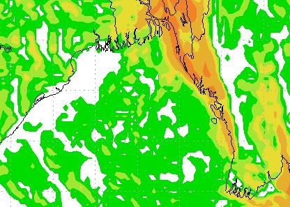
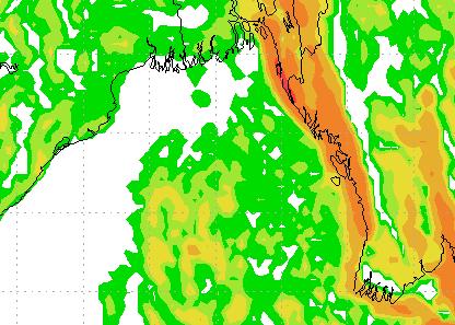
19 Rain (mm) 03 & 04 July 18 Rain (mm) 04 & 05 July 18 Precipitation Scale (mm):
20 Tidal Information 03 July July July 18 KHAL NO. 10 COX S BAZAR HIRAN POINT Time Height Time Height Time Height Time Height Time Height Time Height Time Height Time Height Time Height
WEATHER FORECAST DHAKA
 WEATHER FORECAST DHAKA 05.09.2018 Hourly 2 PM 4 PM 8 PM 11 PM Temp. / Dew Point 33 / 25 32 / 25 29 / 24 28 / 25 Wind 18 km/h ESE 16 km/h SE 15 km/h SE 15 km/h ESE Humidity 64% 67% 78% 81% Chance of Precip
WEATHER FORECAST DHAKA
 WEATHER FORECAST DHAKA 02.01.2019 Hourly 2 PM 4 PM 8 PM 11 PM Temp. / Dew Point 26 / 12 25 / 12 20 / 12 18 / 13 Wind 15 km/h WNW 13 km/h WNW 4 km/h WNW 6 km/h WNW Humidity 41% 43% 62% 71% Chance of Precip
WEATHER FORECAST DHAKA
 WEATHER FORECAST DHAKA 21.10.2017 Hourly 1 PM 4 PM 8 PM 11 PM Temp. / Dew Point 26 / 24 26 / 23 26 / 22 26 / 22 Wind 20 km/h S 29 km/h SSW 17 km/h SW 13 km/h WSW Humidity 91% 86% 79% 78% Chance of Precip
WEATHER FORECAST DHAKA
 WEATHER FORECAST DHAKA 06.09.2018 Hourly 2 PM 4 PM 8 PM 11 PM Temp. / Dew Point 32 / 24 30 / 24 28 / 24 28 / 25 Wind 27 km/h SE 27 km/h SE 24 km/h SE 21 km/h SE Humidity 63% 68% 78% 80% Chance of Precip
Country Report of Bangladesh On
 Country Report of Bangladesh On EFFECTIVE TROPICAL CYCLONE WARNING IN BANGLADESH Presented At JMA/WMO WORKSHOP ON EFFECTIVE TROPICAL CYCLONE WARNING IN SOUTHEAST ASIA Tokyo, Japan 11-14 March 2014 By Sayeed
California OES Weather Threat Briefing
 California OES Weather Threat Briefing Wednesday, January 16, 2019 9:00 AM PST Day 1: Strong winds, heavy mountain snow and heavy rain with isolated thunderstorms across much of the state through Thursday
Issued by: National Weather Service San Joaquin Valley - Hanford CA. Issue time: 409 AM PST Wed Jan
 Forecast Information Location: New_Exchequer_Dam Updated: January 16, 2019, 11:45 am NWS Weather Discussion: Issued by: National Weather Service San Joaquin Valley - Hanford CA Issue time: 409 AM PST Wed
Cyclone forecasting and its constrains for the Bay of Bengal
 Annex IV JMA/WMO WORKSHOP ON EFFECTIVE TROPICAL CYCLONE WARNING IN SOUTHEAST ASIA Tokyo, Japan 11-14 March 2014 Cyclone forecasting and its constrains for the Bay of Bengal Submitted by Kawsar Parvin Meteorologist
Forecast for 6/28-7/31. Forecaster: Matthew Brewer Forecast made at: 12z 6/27/2017
 Forecast for 6/28-7/31 Forecaster: Matthew Brewer Forecast made at: 12z 6/27/2017 Whiteface lodge Mesonet Meteogram for the past 24 hours http://www.nysmesonet.org/data/meteogram#?stid=wfmb Whiteface Summit
Active Weather Threat Halloween Week Nor easter October 28 th 31 st 2012
 Active Weather Threat Halloween Week Nor easter October 28 th 31 st 2012 Prepared 1130 AM EDT Wednesday, October 24, 2012 Gary Szatkowski NOAA s NJ Forecast Office Weather.gov/phi Purpose of Briefing Briefing
Marshall Alexander Forecaster Commonwealth of Dominica
 Marshall Alexander Forecaster Commonwealth of Dominica Dominica 2015 Impacts Tropical Storm Danny (August 24 th ) Tropical Storm Erika (August 27 th ) Tropical Storm Grace (Remnants) (September 10 th -11
National Meteorological Center can be contacted at: / Mail address:
 National Meteorological Center can be contacted at: 597-6806599/ 597-325190 Mail address: infometeozan@publicworks.gov.sr WEATHER FOR SURINAME Valid from 07.00lt January 08 till 07.00lt January 09, 2018
CropCast Corn and Soybean Report Kenny Miller Friday, March 17, 2017
 Accumulated Rainfall (inches) Accumulated GDDs Temperature ( F)/Wind Speed (mph) Precipitation (inches) CropCast Corn and Soybean Report Kenny Miller Friday, March 17, 2017 Peoria, IL Regional Forecast
Predicting Weather Conditions. Do you have a career as a meteorologist?
 Predicting Weather Conditions Do you have a career as a meteorologist? It is essential for students for know 1. Weather conditions and patterns can be based on weather data collected from various sources.
February 2011: A Month of Below Average Temperatures, A Record Cold Snap, and a Sharp Frontal Passage with Snow
 1 Steven Mullen February 2011: A Month of Below Average Temperatures, A Record Cold Snap, and a Sharp Frontal Passage with Snow Overview of the Weather and Detail Diagnosis for Feb 25 th -27 th Daily surface
Country Report: Bangladesh
 The 5th International Coordination Group (ICG) Meeting GEOSS Asian Water Cycle Initiative (AWCI) Tokyo, Japan, 15-18, December 2009 Country Report: Bangladesh Monitoring and forecasting of cyclones SIDR
Average Weather For Coeur d'alene, Idaho, USA
 Average Weather For Coeur d'alene, Idaho, USA Information courtesy of weatherspark.com Location This report describes the typical weather at the Coeur d'alene Air Terminal (Coeur d'alene, Idaho, United
Weather Practice. 4. As wind velocity decreases, the distance between isobars on a weather map will A) decrease B) increase C) remain the same
 decrease B) increase C) remain the same") 1. The chart below shows the air temperature and the dewpoint temperature near the ground at a given location for four consecutive days. All temperatures were recorded at noon. Which statement is best
1. The chart below shows the air temperature and the dewpoint temperature near the ground at a given location for four consecutive days. All temperatures were recorded at noon. Which statement is best
TROPICAL STORM HARVEY COE Navigation Call - Update
 TROPICAL STORM HARVEY COE Navigation Call - Update 10:00 AM CDT Tuesday, August 29, 2017 Prepared by: NWS LIX NWSNewOrleans www.weather.gov/neworleans Situation Overview New Information Drifting ENE at
Fun with Weather Maps! (no, really stop laughing) AOSC 200 Tim Canty
 AOSC 200 Tim Canty") Fun with Weather Maps! (no, really stop laughing) AOSC 200 Tim Canty Class Web Site: http://www.atmos.umd.edu/~tcanty/aosc200 Topics for today: Observations Station Model Temperature Maps Pressure Maps
Fun with Weather Maps! (no, really stop laughing) AOSC 200 Tim Canty Class Web Site: http://www.atmos.umd.edu/~tcanty/aosc200 Topics for today: Observations Station Model Temperature Maps Pressure Maps
Lab 19.2 Synoptic Weather Maps
 Lab 19.2 Synoptic Weather Maps Name: Partner: Purpose The purpose of this lab is to have you read and interpret the information displayed on synoptic weather maps. You will also learn the techniques used
Severe Weather Potential for Southeast Texas
 Severe Weather Potential for Southeast Texas Dan Reilly, Kent Prochazka, Scott Overpeck National Weather Service Houston/Galveston 10 am Synopsis Storm to likely bring severe weather to Southeast Texas
Guide to Understanding the Forecast
 Guide to Understanding the Forecast The Antigua and Barbuda Meteorological Service (ABMS) issues forecasts for sky condition, precipitation probability, precipitation accumulation, wind, seas and temperature.
ESCI 1010 Lab 6 Midlatitude Cyclones and Thunderstorms
 ESCI 1010 Lab 6 Midlatitude Cyclones and Thunderstorms Before Lab: Review pages 244-324 in your Weather and Climate textbook. Pay special attention to the sections entitled Fronts, Life Cyclone of a Midlatitude
Tropical Revolving Storm (TRS)
") Tropical Revolving Storm (TRS) Tropical revolving storm (TRS) is a warm-core, low-pressure system, around which the air circulation is anti-clockwise, in the Northern Hemisphere (NH) and clockwise, in
Tropical Revolving Storm (TRS) Tropical revolving storm (TRS) is a warm-core, low-pressure system, around which the air circulation is anti-clockwise, in the Northern Hemisphere (NH) and clockwise, in
NOAA s National Weather Service Philadelphia/Mt. Holly NJ
 Next Briefing Package: Friday, October 2, 2015 no later than 300 PM Hazards and Impacts: Overview: A dangerous weather pattern still threatens our region. Threats include very heavy rainfall, inland river
Storm Summary for Hurricane Jose
 Storm Summary for Hurricane Jose Tuesday, September 19, 2017 at 11 AM EDT (Output from Hurrevac, based on National Hurricane Center Forecast Advisory #57) Jose is currently a Category 1 hurricane on the
Vantage PRO2 Quick. Reference Guide
 Vantage PRO2 Quick Reference Guide INTRO This Quick Reference Guide will provide you with abbreviated instructions for all functions of the Vantage Pro2 console. For more detailed instructions, see Vantage
TROPICAL STORM HARVEY BRIEFING
 TROPICAL STORM HARVEY BRIEFING 10:00 AM CDT Sunday, August 27, 2017 Prepared by: NWS LIX NWSNewOrleans www.weather.gov/neworleans Situation Overview New Information Tropical Storm Winds 40mph Immediate
TROPICAL STORM HARVEY BRIEFING
 TROPICAL STORM HARVEY BRIEFING 2:00 PM CDT Tuesday, August 29, 2017 Prepared by: NWS LIX NWSNewOrleans www.weather.gov/neworleans Situation Overview New Information Moving NNE Max sustained wind 45 mph
Nor easter Monday Night Wednesday December 8 10, 2014
 Nor easter Monday Night Wednesday December 8 10, 2014 Prepared 400 PM EST Monday, December 8, 2014 Mitchell Gaines NOAA s Philadelphia/Mount Holly NJ Forecast Office www.weather.gov/phi/ Purpose of Briefing
LOCAL CLIMATOLOGICAL DATA Monthly Summary November 2006
 Deg. Days Precip Ty Precip Wind Sun Hu- Adj. to Sea Level mid- ity Avg Res Res Peak Minute 1 fog 2 hvy fog 3 thunder 4 ice plt 5 hail 6 glaze 7 duststm 8 smk, hz 9 blw snw 1 2 3 4A 4B 5 6 7 8 9 12 14 15
Remote Sensing Observations AOSC 200 Tim Canty
 Remote Sensing Observations AOSC 200 Tim Canty Class Web Site: http://www.atmos.umd.edu/~tcanty/aosc200 Topics for today: Maps Radar Satellite Observations Lecture 04 Feb 7 2019 1 Today s Weather Map http://www.wpc.ncep.noaa.gov/sfc/namussfcwbg.gif
Tropical Storm Colin Briefing Last Briefing on this System
 Tropical Storm Colin Briefing Last Briefing on this System NWS WFO Jacksonville, Florida Tuesday, June 07, 2016 6:00 a.m. EDT Tropical Storm Colin s Impacts SE Georgia & North Florida Local Watches & Warnings:
WEEKEND WEATHER OUTLOOK BELIZE, CENTRAL AMERICA
 WEEKEND WEATHER OUTLOOK BELIZE, CENTRAL AMERICA PERIOD: Friday, July 13 until Monday, July 16, 2012 DATE ISSUED: Friday, June 13, 2012, 9:00 am RFrutos SYNOPSIS: A weak pressure gradient over the NW Caribbean
An upper to mid level circulation (Low) in the NW Caribbean is
 in the NW Caribbean is") WEEKLY WEATHER OUTLOOK BELIZE, CENTRAL AMERICA PERIOD: Monday-Monday, Oct. 1 October 8, 2012 DATE ISSUED: Monday, Oct 1, 2012 6:00 am RFrutos EcoSolutions & Services SYNOPSIS: An upper to mid level circulation
WEEKLY WEATHER OUTLOOK BELIZE, CENTRAL AMERICA PERIOD: Monday-Monday, Oct. 1 October 8, 2012 DATE ISSUED: Monday, Oct 1, 2012 6:00 am RFrutos EcoSolutions & Services SYNOPSIS: An upper to mid level circulation
MARINE WEATHER HINDCAST REPORT
 MARINE WEATHER HINDCAST REPORT PREPARED FOR US SAILING INVESTIGATIVE PANEL VESSEL : Aegean INCIDENT LOCATION : APPROX 32.45N 117.30W INCIDENT TIME : APPROX 1:30AM Apr. 28 2012 PREPARED BY SAM WILSON M.S.
Quick Reference Guide
 Vantage PRO Davis Instruments 3465 Diablo Ave, Hayward, CA 94545 U.S.A. Phone (510) 732 9229 Fax (510) 732 9188 www.davisnet.com E-mail: sales@davisnet.com support@davisnet.com Quick Reference Guide Part
4thscience_earth (4thscience_earth)
") Name: Date: 1. The temperature at noon for the last week is shown in the graph. Which day had a lower temperature than Tuesday? A. Monday B. Wednesday C. Thursday D. Saturday 2. Which instrument would
Name: Date: 1. The temperature at noon for the last week is shown in the graph. Which day had a lower temperature than Tuesday? A. Monday B. Wednesday C. Thursday D. Saturday 2. Which instrument would
Chapter 2 Weather Patterns Guided Notes Objective(s): 7.E.1.4 Predict weather conditions and patterns based on information obtained from:
: 7.E.1.4 Predict weather conditions and patterns based on information obtained from:") Chapter 2 Weather Patterns Guided Notes Objective(s): 7.E.1.4 Predict weather conditions and patterns based on information obtained from: Weather data collected from direct observations and measurement
Chapter 2 Weather Patterns Guided Notes Objective(s): 7.E.1.4 Predict weather conditions and patterns based on information obtained from: Weather data collected from direct observations and measurement
Government of Sultanate of Oman Public Authority of Civil Aviation Directorate General of Meteorology. National Report To
 Government of Sultanate of Oman Public Authority of Civil Aviation Directorate General of Meteorology National Report To Panel on Tropical Cyclones in the Bay of Bengal And Arabian Sea 43rd Session, India
HURRICANE HARVEY COE Navigation BRIEFING
 HURRICANE HARVEY COE Navigation BRIEFING 10:00 AM CDT Friday, August 25, 2017 NWSNewOrleans www.weather.gov/neworleans Situation Overview New Information Harvey continues to strengthen Max sustained winds
Hurricane Irma Page 1 HURRTRAK RM/Pro 2017 Summary Report for Tampa, FL 09/10/ EDT, Adv. # 46
 Hurricane Irma Page 1 Description of impact to Tampa, FL, Tampa, FL, is expected to receive a major impact from Hurricane Irma. The forecast maximum wind for this location has increased since the last
2016 EXPLANATION OF OBSERVATIONS BY REFERENCE NUMBER
 S 2016 EXPLANATION OF OBSERVATIONS BY REFERENCE NUMBER tation was moved to 10905 Virginia Forest Court Glen Allen, Virginia in Henrico County on June 10, 2008. Latitude 37 39' 18.87" (37.65537) Longitude
Answers to Clicker Questions
 Answers to Clicker Questions Chapter 1 What component of the atmosphere is most important to weather? A. Nitrogen B. Oxygen C. Carbon dioxide D. Ozone E. Water What location would have the lowest surface
Average Weather In March For Fukuoka, Japan
 Average Weather In March For Fukuoka, Japan Location This report describes the typical weather at the Fukuoka Airport (Fukuoka, Japan) weather station over the course of an average March. It is based on
NOAA s National Weather Service Philadelphia/Mt. Holly NJ
 Next Briefing Package: Thursday, October 1, 2015 no later than 300 PM Hazards and Impacts: Overview: A dangerous weather pattern is developing for our region. Threats include very heavy rainfall, inland
CropCast Corn and Soybean Report Kenny Miller Tuesday, March 14, 2017
 Accumulated Rainfall (inches) Accumulated GDDs Temperature ( F)/Wind Speed (mph) Precipitation (inches) CropCast Corn and Soybean Report Kenny Miller Tuesday, March 14, 2017 Peoria, IL Regional Forecast
Page 1. Name:
 Name: 1) As the difference between the dewpoint temperature and the air temperature decreases, the probability of precipitation increases remains the same decreases 2) Which statement best explains why
WEEKLY WEATHER OUTLOOK BELIZE, CENTRAL AMERICA
 WEEKLY WEATHER OUTLOOK BELIZE, CENTRAL AMERICA PERIOD: Sunday, June 17 until Monday, June 25, 2012 DATE ISSUED: Sunday, June 17, 2012; 3:00 pm RFrutos EcoSolutions & Services SYNOPSIS: An upper level trough
Management in Surface, Climate and Upper-air Observations in RAII,Tokyo, Assistant Director Bangladesh Meteorological Department
 JMA / WMO Workshop on Quality Management in Surface, Climate and Upper-air Observations in RAII,Tokyo, 27-30 July 2010 Shamsuddin Ahmed Assistant Director Bangladesh Meteorological Department Bangladesh
4. Which map best represents the type of fronts and direction of movement of these fronts in relation to the low-pressure center?
 1. Adjacent water and landmasses are heated by the morning Sun on a clear, calm day. After a few hours, a surface wind develops. Which map best represents this wind's direction? 2. An air pressure of 29.47
LOCAL CLIMATOLOGICAL DATA Monthly Summary July 2013
 Deg. Days Precip Ty Precip Wind Solar Hu- Adj. to Sea Level mid- ity Avg Res Res Peak Minute 1 fog 2 hvy fog 3 thunder 4 ice plt 5 hail 6 glaze 7 duststm 8 smk, hz 9 blw snw 1 2 3 4A 4B 5 6 7 8 9 12 14
LOCAL CLIMATOLOGICAL DATA Monthly Summary September 2016
 Deg. Days Precip Ty Precip Wind Solar Hu- Adj. to Sea Level mid- ity Avg Res Res Peak 2 Minute 1 fog 2 hvy fog 3 thunder 4 ice plt 5 hail 6 glaze 7 duststm 8 smk, hz 9 blw snw 1 2 3 4A 4B 5 6 7 8 9 11
PROBABILISTIC EXTREMES OF THE FREQUENCY OF THUNDERSTORM DAYS OVER BANGLADESH DURING THE PRE- MONSOON SEASON
 225 PROBABILISTIC EXTREMES OF THE FREQUENCY OF THUNDERSTORM DAYS OVER BANGLADESH DURING THE PRE- MONSOON SEASON Samarendra Karmakar Bangladesh Meteorological Department, Sher-e-Bangla Nagar, Agargaon Dhaka-1207,
Satellite and Radar. 5:55 am Infrared Satellite with Surface Wind Arrows. 6:15 am Ruskin Doppler Radar. Large southerly wind field
 Satellite and Radar 5:55 am Infrared Satellite with Surface Wind Arrows 6:15 am Ruskin Doppler Radar Large southerly wind field Developing showers rotating onshore NHC Forecast Hurricane Warning Big Bend
Weather briefing Strong Coastal Nor easter November 7 th -8 th, 2012
 Weather briefing Strong Coastal Nor easter November 7 th -8 th, 2012 Prepared 1215 PM EDT Wednesday November 7, 2012 Gary Szatkowski NOAA s NJ Forecast Office http://www.erh.noaa.gov/phi/ Purpose of Briefing
ARUBA CLIMATOLOGICAL SUMMARY 2014 PRECIPITATION
 ARUBA CLIMATOLOGICAL SUMMARY 2014 PRECIPITATION The total amount of rainfall recorded at Reina Beatrix International Airport for the year 2014 was 309.2 mm. This is 34.4 % below normal ( Figure 1 ). During
WM9280. Pro Family weather station with T/H sensor, pluviometer, anemometer, PC connection and Meteotime weather forecasts until 3 days
 Technical sheet Pro Family weather station with T/H sensor, pluviometer, anemometer, PC connection and Meteotime weather forecasts until 3 days RADIO-CONTROLLED TIME AND DATE - WEATHER FORECASTS FOR CURRENT
Coastal Storm this Weekend
 Weather Briefing Prepared 9 AM EST Feb 5, 2010 Joe Miketta Warning Coordination Meteorologist NOAA s National Weather Service Philadelphia/Mt. Holly NJ Forecast Office 609-261 261-6602 6602 x223 Joseph.Miketta@noaa.gov
Maps and Remote Sensing AOSC 200 Tim Canty
 Maps and Remote Sensing AOSC 200 Tim Canty Class Web Site: http://www.atmos.umd.edu/~tcanty/aosc200 Topics for today: Weather Maps Radar Satellite Observations Lecture 04 Feb 7 2019 1 Today s Weather Map
Temperature, Observations, and Maps AOSC 200 Tim Canty. Weather and Climate
 Temperature, Observations, and Maps AOSC 200 Tim Canty Class Web Site: http://www.atmos.umd.edu/~tcanty/aosc200 Topics for today: Climate Weather Observations Weather Maps Lecture 03 Feb 5 2019 1 Weather
Coastal Storm. Wednesday through Friday, 3/6-8/2013 Weather Briefing
 Coastal Storm Wednesday through Friday, 3/6-8/2013 Weather Briefing Prepared 2:00 PM EST Wednesday, March 6, 2013 National Weather Service New York, NY Purpose of Briefing Promote Situational Awareness
CropCast Corn and Soybean Report Kyle Tapley Monday, March 20, 2017
 Accumulated Rainfall (inches) Accumulated GDDs Temperature ( F)/Wind Speed (mph) Precipitation (inches) CropCast Corn and Soybean Report Kyle Tapley Monday, March 20, 2017 Peoria, IL Regional Forecast
WEEKLY OUTLOOK Valid: June 24-July 1, 2013
 WEEKLY OUTLOOK Valid: June 24-July 1, 2013 Issue: 6:00 am Tuesday, June 24, 2013 SYNOPSIS for 6:00am Tuesday, June 24, 2013 RESIDUAL INSTABILITY IN THE MOIST EASTERLY AIRFLOW INDUCED BY A SHORT-WAVE TROUGH
Name Period 4 th Six Weeks Notes 2013 Weather
 Name Period 4 th Six Weeks Notes 2013 Weather Radiation Convection Currents Winds Jet Streams Energy from the Sun reaches Earth as electromagnetic waves This energy fuels all life on Earth including the
DEPARTMENT OF EARTH & CLIMATE SCIENCES SAN FRANCISCO STATE UNIVERSITY. Metr Fall 2014 Test #1 September 30, 2014
 DEPARTMENT OF EARTH & CLIMATE SCIENCES SAN FRANCISCO STATE UNIVERSITY NAME Metr 302.02 Fall 2014 Test #1 September 30, 2014 200 pts (4 pts each answer) Part I. Surface Chart Interpretation. Questions 1
Red Butte Creek Oil Release Air Monitoring Journal Date Location (Time) Analyte Method Result GPS Location Comment
 Analyte Method Result GPS Location Comment") Date Location (Time) Analyte Method Result GPS Location Comment 6/30/10 ~1800 East Sunnyside Ave. (1110-1145) Miller Park, along Red Butte Creek (1150-1210) 0.2-1.0 ppm 1 Upstream of pressure-washing crews.
Date Location (Time) Analyte Method Result GPS Location Comment 6/30/10 ~1800 East Sunnyside Ave. (1110-1145) Miller Park, along Red Butte Creek (1150-1210) 0.2-1.0 ppm 1 Upstream of pressure-washing crews.
WEEKLY WEATHER OUTLOOK BELIZE, CENTRAL AMERICA
 WEEKLY WEATHER OUTLOOK BELIZE, CENTRAL AMERICA PERIOD: Sunday, July 1 until Monday, July 9, 2012 DATE ISSUED: Sunday, July 1, 2012 3:00 pm RFrutos EcoSolutions & Services SYNOPSIS: The features of interest
A) B) C) D) 2) The diagrams below show the phases of the Moon as viewed by an observer in New York State at different times in August.
 B) C) D) 2) The diagrams below show the phases of the Moon as viewed by an observer in New York State at different times in August.") Name: 1) Which weather station model indicates the highest relative humidity? 8605-1 - Page 1 A) B) C) D) 2) The diagrams below show the phases of the Moon as viewed by an observer in New York State at
Name: 1) Which weather station model indicates the highest relative humidity? 8605-1 - Page 1 A) B) C) D) 2) The diagrams below show the phases of the Moon as viewed by an observer in New York State at
Sample. Location: Time: Date: Your Reference: My Reference: Ratho (EH28 8RL) th December 2013 XXXXXXXXXXXXXXX XXXX (XX)
 th December 2013 XXXXXXXXXXXXXXX XXXX (XX)") WeatherNet Limited Kingsland House 21 Hinton Road Bournemouth BH1 2DE Telephone 122 296396 Facsimile 122 31464 XXXXXXXX XXXXXXX XXXXXXXXX XX XXXXXX XXXXXX XXXXXXXXX XXX XXX Tel: XXXX XXX XXXX Direct Dial:
WeatherNet Limited Kingsland House 21 Hinton Road Bournemouth BH1 2DE Telephone 122 296396 Facsimile 122 31464 XXXXXXXX XXXXXXX XXXXXXXXX XX XXXXXX XXXXXX XXXXXXXXX XXX XXX Tel: XXXX XXX XXXX Direct Dial:
CASE STUDY: Tropical Cyclone Monica, April 2006
 CASE STUDY: Tropical Cyclone Monica, April 2006 By Mr Jeff Callaghan Retired Senior Severe Weather Forecaster, Bureau of Meteorology, Brisbane The track of tropical cyclone Monica (Figure 1) took it from
HURRICANE IRMA. 12 PM ET Saturday, September Prepared by: Kyle Thiem / Sid King.
 HURRICANE IRMA 12 PM ET Saturday, September 9 2017 Prepared by: Kyle Thiem / Sid King www.weather.gov/atlanta/briefings @NWSAtlanta www.weather.gov/atlanta Situation Overview 11:00 AM EDT Sat Sep 9 Location:
Name 28-MAY-08. FA RP 1 Mr. Chase. 1. Which weather-station model shows an air pressure of millibars?
 FA RP 1 Mr. Chase Name 28-MAY-08 1. Which weather-station model shows an air pressure of 993.4 millibars? 2. Which station model shows the correct form for indicating a northwest wind at 25 knots and an
DEPARTMENT OF EARTH & CLIMATE SCIENCES Name SAN FRANCISCO STATE UNIVERSITY Nov 29, ERTH 360 Test #2 200 pts
 DEPARTMENT OF EARTH & CLIMATE SCIENCES Name SAN FRANCISCO STATE UNIVERSITY Nov 29, 2018 ERTH 360 Test #2 200 pts Each question is worth 4 points. Indicate your BEST CHOICE for each question on the Scantron
43rd Session of The WMO/ESCAP PANEL on Tropical Cyclones New Delhi, India May, 2016
 43rd Session of The WMO/ESCAP PANEL on Tropical Cyclones New Delhi, India 02-06 May, 2016 Shamsuddin Ahmed Director Bangladesh Meteorological Department METEOROLOGY Cyclonic Disturbances over the Bay of
Weather briefing Strong Coastal Nor easter November 7 th -8 th, 2012
 Weather briefing Strong Coastal Nor easter November 7 th -8 th, 2012 Prepared 1245 PM EDT Tuesday November 6, 2012 Gary Szatkowski NOAA s NJ Forecast Office Weather.gov/phi Purpose of Briefing Briefing
WEATHER MAPS NAME. Temperature: Dew Point: Wind Direction: Wind Velocity: % of Sky Covered: Current Pressure:
 NAME WEATHER MAPS For decades hundreds of weather stations throughout the United States have been making standard observations of temperature, moisture, air pressure and winds. The data are collected centrally
Tropics: Weather Forecasting And Early Warning System in Bangladesh.
 Regional Workshop on Impact-based Forecast in RA II (Asia) 07-09,November 2017 Seoul, Republic of Korea. Tropics: Weather Forecasting And Early Warning System in Bangladesh. Md. Sanaul Hoque Mondal Assistant
'Day in the Life' Physical Data 10/18/11. RM : cm site tube. typical fall, sun, clouds, small rain mostly 1 South calm
 RM Site Time Time 24 hr clock Air Temp. C Air Temp. F RM 300 6:00 3.33 38 clear RM 200 10:07 12 52 cloudy RM 153 9:52 20 62 rain Weather Today Weather Last 3 days cool, slight rain, rain last night windy,
Chapter 1 Anatomy of a Cyclone
 Chapter 1 Anatomy of a Cyclone The Beast in the East 15-17 February 2003 Extra-tropical cyclone an area of low pressure outside of the tropics Other names for extra-tropical cyclones: Cyclone Mid-latitude
APPENDIX G-7 METEROLOGICAL DATA
 APPENDIX G-7 METEROLOGICAL DATA METEOROLOGICAL DATA FOR AIR AND NOISE SAMPLING DAYS AT MMR Monthly Normals and Extremes for Honolulu International Airport Table G7-1 MMR RAWS Station Hourly Data Tables
ERTH 365 Homework #2: Hurricane Harvey. 100 points
 ERTH 365 Homework #2: Hurricane Harvey 100 points Due by 6pm, Tuesday 30 October 2018, ELECTRONIC SUBMISSON BY EMAIL ONLY BY 6PM (send to klevey@sfsu.edu) (acceptable formats: MS Word, Google Doc, plain
Sources of Hourly Surface Data and Weather Maps for the U.S.
 Sources of Hourly Surface Data and Weather Maps for the U.S. Weather Underground Weather Underground http://www.wunderground.com/history/ maintains a deep archive of hourly reports for around the world.
A Prepared Marylander Creates a Resilient Maryland
 Maryland Emergency Management Agency Operations Directorate Hazardous Winter Weather Outlook Briefing March 5, 2013 0800 A Prepared Marylander Creates a Resilient Maryland A strong low pressure will track
Some associated features of Severe Thunderstorms in Bangladesh extracted from conventional method and numerical modelling
 International Forum on Tornado Disaster Risk Reduction for Bangladesh -To Cope with Neglected Disasters- 13-14 December 2009, Dhaka, Bangladesh Some associated features of Severe Thunderstorms in Bangladesh
Weather vs. Climate. Tucson NWS homepage:
 Weather vs. Climate Tucson NWS homepage: www.nws.noaa.gov/twc/ A Weather Forecaster? Betty claims to know exactly when it s going to rain because her knee starts to hurt. Ms. Betty Martin of Newburgh,
777 Neptune Groundschool Weather reporting & forecasts
 777 Neptune Groundschool 2018 Weather reporting & forecasts Weather Reporting Weather Forecast is a prediction of what the weather conditions will be in the future Weather Report tells the reader of what
(1) a hurricane warning (2) a gale warning (3) a storm watch (4) a storm warning (5) a hurricane watch
 a hurricane warning (2) a gale warning (3) a storm watch (4) a storm warning (5) a hurricane watch") Instructor: Prof. Seiberling PHYSICS DEPARTMENT MET 1010 Final Exam December 15, 2003 Name (print, last rst): Signature: On my honor, I have neither given nor received unauthorized aid on this examination.
Instructor: Prof. Seiberling PHYSICS DEPARTMENT MET 1010 Final Exam December 15, 2003 Name (print, last rst): Signature: On my honor, I have neither given nor received unauthorized aid on this examination.
TROPICAL STORM HARVEY BRIEFING
 TROPICAL STORM HARVEY BRIEFING 1 PM CDT Saturday, August 26, 2017 Prepared by: John Metz NWSCorpus www.weather.gov/corpuschristi Overview Life-threatening conditions continue. Storm Surge Warnings remain
latent heat/humidity
 1. Base your answer(s) to the following question(s) on the Earth Science Reference Tables, the graph below, and your knowledge of Earth science. The graph shows variations in air temperature and relative
REGRESSION FORECASTING OF PRE-MONSOON RAINFALL IN BANGLADESH ABSTRACT
 Proceedings of the SAAC Seminar on Agricultural Applications of Meteorology, held on 23-24 December 2003, published by SMC in 2004 EGESSION FOECASTING OF PE-MONSOON AINFALL IN BANGLADESH SAMAENDA KAMAKA
Storm Summary for Hurricane Joaquin
 Storm Summary for Hurricane Joaquin Wednesday, September 30, 2015 at 5 PM EDT (Output from Hurrevac, based on National Hurricane Center Forecast Advisory #12) Joaquin is currently a Category 1 hurricane
Weather Briefing Mixed Winter Storm Event February 26-27, 2013
 Weather Briefing Mixed Winter Storm Event February 26-27, 2013 Prepared 1200 PM EST Tuesday, February 26th, 2013 Joe Miketta NOAA s NJ Forecast Office http://www.erh.noaa.gov/phi/ Purpose of Briefing Briefing
Electronic Station Data Definitions
 Electronic Station Data Definitions CODE DATE TIME Station Code Date and time of OBS TYPE Observation Type ST - "Standard Observations" collected at 0600 and 1800, RAW - hourly s collected every hour,
Major Winter Storm to impact Western Washington. 17 January 2012 National Weather Service Seattle/Tacoma
 Major Winter Storm to impact Western Washington 17 January 2012 National Weather Service Seattle/Tacoma Current Warnings Winter Storm Warning for all of Western Washington, except: Northwest interior Extreme
Custom Weather Forecast
 1 of 23 Custom Weather Forecast 2018 Chicago Yacht Club s Race To Mackinac- Cruising Division Disclaimer: The user assumes all risk related to the use of this Custom Weather Forecast. The crew of the participating
DEPARTMENT OF GEOSCIENCES SAN FRANCISCO STATE UNIVERSITY. Metr Fall 2012 Test #1 200 pts. Part I. Surface Chart Interpretation.
 DEPARTMENT OF GEOSCIENCES SAN FRANCISCO STATE UNIVERSITY NAME Metr 356.01 Fall 2012 Test #1 200 pts Part I. Surface Chart Interpretation. Figure 1. Surface Chart for 1500Z 7 September 2007 1 1. Pressure
Tropical Update. 5 AM EDT Tuesday, September 12, 2017 Post-Tropical Cyclone Irma, Hurricane Jose, & Tropical Wave (10%)
") Tropical Update 5 AM EDT Tuesday, September 12, 2017 Post-Tropical Cyclone Irma, Hurricane Jose, & Tropical Wave (10%) This update is intended for government and emergency response officials, and is provided
Tropical Update 5 AM EDT Tuesday, September 12, 2017 Post-Tropical Cyclone Irma, Hurricane Jose, & Tropical Wave (10%) This update is intended for government and emergency response officials, and is provided
CropCast Corn and Soybean Report Kenny Miller Monday, March 13, 2017
 Accumulated Rainfall (inches) Accumulated GDDs Temperature ( F)/Wind Speed (mph) Precipitation (inches) CropCast Corn and Soybean Report Kenny Miller Monday, March 13, 2017 Peoria, IL Regional Forecast