A G E N D A Planning Session April 5, :45 p.m.
|
|
|
- Alan Ferguson
- 6 years ago
- Views:
Transcription
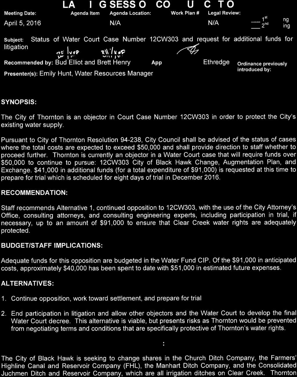
1 ITY OF THORNTON ITY MANAGER S OFFIE A G E N D A Planning Session April 5, :45 p.m. 1. ouncil Operational Tour ity Water Facilities* - Burlington Ditch Diversion from the South Platte River 6:00 (Franklin St. and Race t.) - Thornton Burlington Ditch Road 6:20 (off 74 th Ave) - South Tani hemical Feed Station 6:40 (76 Frontage Rd.) - Lower lear reek Diversion into West Gravel Lakes 6:55 (8400 Block of Devonshire Blvd) -Wes Brown Water 7:05 (3651 E 86th Ave) - Thornton Water 8:20 (9520 Ellen t.) 2. Status of Water ourt ase Number 12W303 and request for additional funds for litigation. 3. Rocky Flats Stewardship ouncil Board Meeting Update by ouncilmember Kulmann * These times are estimates and may change slightly due to traffic

2 1
3 Federal Blvd olorado Blvd ity of Thornton- lear reek and South Platte System Rogers Pit « th Ave Big Dry reek Farmers Highline anal 25 olorado Agricultural Ditch Lower lear reek anal Standley Lake Pipeline UVE 470 South Platte River East ooley Pit Hammer Pit Barr Lake hurch Ditch «93 ITY OF THORNTON, OLORADO WASHINGTON ST THORNTON, O (720) PROPRIETARY INFORMATION - - NOT FOR RESALE Digital Data Produced by the ity of Thornton GIS Project. This map is representational only, and does not determine exact locations or boundaries of any districts or properties. It is not intended to be reliedupon for any legal descriptions or other land use documents. Standley Lake Farmers Highline anal roke anal lear reek West Gravel Lakes System East Brannan Lake Reservoir West Brannan Lake Reservoir West Gravel Lake Reservoir No.1 West Gravel Lake Reservoir No.2 West Gravel Lake Reservoir No.3 Fisher Ditch Sheridan Blvd 70 Thornton Water 25!( Wes Brown Water / 0.5 August 5, 2014!( South Platte River!( Miles Burlington anal 76 Robert W. Hite Wastewater East Gravel Lakes System South Tani Reservoir East Gravel Lake #4 Reservoir South Dahila Reservoir North Dahila Reservoir East-Sprat Platte Reservoir West ooley Reservoir** West-Sprat Platte Reservoir** UVE 470 Notes: -The East Gravel Lakes System are filled from South Platte supplies through the Burlington anal. -The West Gravel lakes System are filled from lear reek supplies through the Lower lear reek anal or the olorado Agricultural Ditch. -West-Sprat Platte Reservoir is not inter-connected to the other reservoirs at this time ** West ooley and West-Sprat Platte Reservoir can be filled from either source. Exchange/Reuse Reservoirs West Gravel Lakes System East Gravel Lakes System ity of Thornton Boundary S:\ID\WR\Maps\2014 Thornton System Maps\lear reek and South Platte System.mxd

4 or olorado Boulevard ol ity of Thornton Reservoir Storage South Tani to ooley West North ell ooley West 104th Avenue Middle ell ooley West York Street South ell ooley West West Sprat Platte Thornton Parkway East Sprat Platte Pl at te Ri ve r Thornton Water So u th North Dahlia 88th Avenue 76 Washington Street Wes Brown Water West Gravel Lake #2 South Dahlia West Gravel Lake #1 East Gravel Lake #4 Lo 270 we r a le r re ek an on al Di tc h West Gravel Lake #3 gt A ch lin do lt Dit Bu r ra olo cu gr i l ur a South Tani Brannan Lakes le ar r ee k ITY OF THORNTON WASHINGTON ST THORNTON, O (720) PROPRIETARY INFORMATION - - NOT FOR RESALE Digital Data Produced by the ity of Thornton GIS Project. This map is representational only, and does not determine exact locations or boundaries of any districts or properties. It is not intended to be relied upon for any legal descriptions or other land use documents. S:\ID/WR/Maps/2014 Thornton System Maps/OT Reservoir Storage South Tani to ooley West Aerial August 5, / Miles
5 2
6 PLANNING SESSION OMMUNIATION PAGE 2 owns 152 shares in the FHL, 17.5 of which have not yet been changed to municipal use; collectively, these water rights provide approximately 3,000 acre-feet of yield to Thornton s system. The State of olorado, the ity of Golden, and Public Service ompany (Xcel) are also objectors in this case, and have taken positions that may negatively impact the amount of water Thornton is able to use under its FHL water rights. Thornton s opposition is focused on engineering assumptions that are being proposed by the State, Golden, and Public Service ompany that would impact the amount of water that can be diverted by municipal users on the Farmers Highline. Settlement negotiations will continue; however, trial is scheduled for December 2016 and Thornton must also begin to prepare for trial. Staff will keep ity ouncil informed of the status the case.
SPRINGVILLE CITY, UTAH PRESSURE IRRIGATION SYSTEM DRAFT. MASTER PLAN & CAPITAL FACILITIES PLAN For the WEST FIELDS. February 11, 2014.
 SPRINGVILLE CITY, UTAH PRESSURE IRRIGATION SYSTEM MASTER PLAN & CAPITAL FACILITIES PLAN For the WEST FIELDS February 11, 2014 Prepared by: J-U-B ENGINEERS, INC. 240 West Center Street, Suite 200 Orem,
SPRINGVILLE CITY, UTAH
 SPRINGVILLE CITY, UTAH PRESSURE IRRIGATION SYSTEM MASTER PLAN & CAPITAL FACILITIES PLAN For the WEST FIELDS February 11, 2014 Adopted May 20, 2014 Prepared by: J-U-B ENGINEERS, INC. 240 West Center Street,
Information for File # MMJ; Trunk Highway (TH) 7 / Louisiana Ave. Interchange Project
 7 / Louisiana Ave. Interchange Project") Information for File # 2013-00531-MMJ; Trunk Highway (TH) 7 / Louisiana Ave. Interchange Project Applicant: City of St. Louis Park Corps Contact: Melissa Jenny Address: U.S. Army Corps of Engineers Attn:
Information for File # 2013-00531-MMJ; Trunk Highway (TH) 7 / Louisiana Ave. Interchange Project Applicant: City of St. Louis Park Corps Contact: Melissa Jenny Address: U.S. Army Corps of Engineers Attn:
TREASURE COAST REGIONAL PLANNING COUNCIL M E M O R A N D U M. To: Council Members AGENDA ITEM 4B10
 TREASURE COAST REGIONAL PLANNING COUNCIL M E M O R A N D U M To: Council Members AGENDA ITEM 4B10 From: Date: Subject: Staff December 14, 2018 Council Meeting Local Government Comprehensive Plan Review
THE TRINITY RIVER VISION/ GATEWAY PARK / PANTHER ISLAND
 Quarterly Project Status Report May 2018 THE TRINITY RIVER VISION/ GATEWAY PARK / PANTHER ISLAND Flood Control Project Update Construction of North Main Street Bridge by TxDOT s bridge contractor, Texas
THE TRINITY RIVER VISION/ GATEWAY PARK / PANTHER ISLAND Flood Control Project Update
 Quarterly Project Status Report September 2018 THE TRINITY RIVER VISION/ GATEWAY PARK / PANTHER ISLAND Flood Control Project Update TxDot s contractor has nearly completed the superstructure false work
APPLICATION TO AMEND THE FUTURE LAND USE MAP (FLUM) SMALL SCALE
 SMALL SCALE") DEPARTMENT OF DEVELOPMENT & PLANNING 825 Ohio Avenue - Lynn Haven, FL 32444 (850) 265-2961 - (850) 265-3478 APPLICATION TO AMEND THE FUTURE LAND USE MAP (FLUM) SMALL SCALE Deadline to submit is 30 days
DEPARTMENT OF DEVELOPMENT & PLANNING 825 Ohio Avenue - Lynn Haven, FL 32444 (850) 265-2961 - (850) 265-3478 APPLICATION TO AMEND THE FUTURE LAND USE MAP (FLUM) SMALL SCALE Deadline to submit is 30 days
Border Wars Texas Fight for Water. Today s Presentation
 Border Wars Texas Fight for Water P. Ryan Langston ryan.langston@strasburger.com (469) 287-3814 Today s Presentation The Need for Water the Drought The Legal Foundation Surface Water v. Groundwater Interstate
NOTICE OF PUBLIC HEARING GREEN MEADOWS ANNEXATION (Formally Known as Rude Annexation) (File No. A-17-04)
 (File No. A-17-04)") NOTICE OF PUBLIC HEARING GREEN MEADOWS ANNEXATION (Formally Known as Rude Annexation) (File No. A-17-04) NOTICE IS HEREBY GIVEN that the City Council of Post Falls will hold a public hearing at City Hall,
NOTICE OF PUBLIC HEARING GREEN MEADOWS ANNEXATION (Formally Known as Rude Annexation) (File No. A-17-04) NOTICE IS HEREBY GIVEN that the City Council of Post Falls will hold a public hearing at City Hall,
APPLICATION FOR CONDITIONAL ABSOLUTE WATER STORAGE RIGHT
 District Court, Water Division, Colorado Court Address: CONCERNING THE APPLICATION FOR WATER RIGHTS OF Applicant: In the River or its Tributaries In COUNTY Attorney or Party Without Attorney (Name and
IMPERIAL COUNTY PLANNING AND DEVELOPMENT
 IMPERIAL COUNTY PLANNING AND DEVELOPMENT GEODATABASE USER MANUAL FOR COUNTY BUSINESS DEVELOPMENT GIS June 2010 Prepared for: Prepared by: County of Imperial Planning and Development 801 Main Street El
NATHAN HALE HIGH SCHOOL PARKING AND TRAFFIC ANALYSIS. Table of Contents
 Parking and Traffic Analysis Seattle, WA Prepared for: URS Corporation 1501 4th Avenue, Suite 1400 Seattle, WA 98101-1616 Prepared by: Mirai Transportation Planning & Engineering 11410 NE 122nd Way, Suite
Proclaiming Certain Lands as Reservation for the Confederated Tribes of the
 This document is scheduled to be published in the Federal Register on 11/05/2018 and available online at https://federalregister.gov/d/2018-24174, and on govinfo.gov [4337-15] DEPARTMENT OF THE INTERIOR
AWOS Level Descriptions
 AWOS Level Descriptions AWOS System Configurations. The AWOS is a modular system utilizing a central processor which may receive input from several sensors. Eight standard groups of sensors are defined
Mountain View Community Shuttle Monthly Operations Report
 Mountain View Community Shuttle Monthly Operations Report October 9, 2018 Contents Passengers per Day, Table...- 3 - Passengers per Day, Chart...- 3 - Ridership Year-To-Date...- 4 - Average Daily Ridership
Name of Applicant Mailing Address address Telephone Number
 District Court, Water Division, Colorado Court Address: CONCERNING THE APPLICATION FOR WATER RIGHTS OF Applicant: In the River or its Tributaries In COUNTY Attorney or Party Without Attorney (Name and
DK DM M EMORANDUM D ECEMBER 28, 2018 SUBJECT:
 TO: CC: FROM: SUBJECT: BOARD OF DIRECTORS M EMORANDUM D ECEMBER 28, 2018 ANDY MUELLER, GENERAL MANAGER DAVE DK KANZER, P.E. & DON MEYER, P.E. DK DM COLORADO RIVER BASIN WATER SUPPLY CONDITIONS UPDATE AND
Technical Memorandum. City of Salem, Stormwater Management Design Standards. Project No:
 Technical Memorandum 6500 SW Macadam Avenue, Suite 200 Portland, Oregon, 97239 Tel: 503-244-7005 Fax: 503-244-9095 Prepared for: Project Title: City of Salem, Oregon City of Salem, Stormwater Management
Wesley Chapel Area Roadway Needs Study Build-Out Analysis (Beardsley Dr/Oldwoods Ave Need Study) Project Progress Meeting 1
 Project Progress Meeting 1") Build-Out Analysis (Beardsley Dr/Oldwoods Ave Need Study) Project Progress Meeting 1 9:30 AM Pasco County Development Services Conference Room 1. Welcome/Introductions 2. Project Overview Purpose Major
Build-Out Analysis (Beardsley Dr/Oldwoods Ave Need Study) Project Progress Meeting 1 9:30 AM Pasco County Development Services Conference Room 1. Welcome/Introductions 2. Project Overview Purpose Major
DELTA COUNTY. CASE NO. 2017CW43
 IN THE DISTRICT COURT IN AND FOR WATER DIVISION NO. 4 STATE OF COLORADO TO: ALL PERSONS INTERESTED IN WATER APPLICATIONS IN SAID WATER DIVISION NO. 4 Pursuant to C.R.S. 37-92-302, as amended, you are notified
III. FORECASTED GROWTH
 III. FORECASTED GROWTH In order to properly identify potential improvement projects that will be required for the transportation system in Milliken, it is important to first understand the nature and volume
BEFORE THE BOARD OF COUNTY COMMISSIONERS OF LANE COUNTY, OREGON
 BEFORE THE BOARD OF COUNTY COMMISSIONERS OF LANE COUNTY, OREGON ORDER NO. 18-04-10-06 IN THE MATTER OF SETTING A PUBLIC HEARING FOR THE PROPOSED SURRENDER OF A PORTION OF COAST GUARD STATION ROAD (COUNTY
Schuyler County Idle Farmland Analysis. Conducted by Cornell Cooperative Extension of Schuyler County
 Schuyler County Idle Farmland Analysis Conducted by Cornell Cooperative Extension of Schuyler County June 15, 2010 Schuyler County Idle Farmland Analysis Purpose: The purpose of this analysis is to approximate
Palo Pinto County Appraisal District Property Info
 Palo Pinto County Appraisal District Property Info Property ID Geo ID Legal: R000036838 030360100.R91786 R000009211 073400000.R91786 Legal: Acres: 396.080, AB 429 TR 13-1 S TOWNSEND (SOUTH OF ) (0.750000
1. Departmental Presentation - Away Goes Trouble Down the Drain - Highway Division. 3. Continued Discussion an Ordinance for Disorderly Residences
 City of Keene New Hampshire MUNICIPAL SERVICES, FACILITIES AND INFRASTRUCTURE COMMITTEE AGENDA Council Chambers B October 11, 2017 6:00 PM Janis O. Manwaring Randy L. Filiault Robert J. O'Connor Stephen
West Hernando County Sewer Master Plan SECTION 2.0 EXISTING WASTEWATER SYSTEM
 SECTION 2.0 EXISTING WASTEWATER SYSTEM 2.1 Background The County operates and maintains extensive wastewater collection, transmission and treatment/disposal facilities on the west side of Hernando County.
D Yes ~ No D To Be Determined
 Project Development and Environmental Analysis Branch Project Data Sheets TIP No.: R-5858 Sent Date: Oct. 8 th 2017 WBS No.: 475546.1.1 Revision Date: Federal Aid No: Meeting Date: Nov. 7 th 2017 Division:
DST MODEL SUPPORT SPATIAL DATA AND WATER RIGHTS INFORMATION. Tim Minor, Desert Research Institute
 DST MODEL SUPPORT SPATIAL DATA AND WATER RIGHTS INFORMATION Tim Minor, Desert Research Institute THIS PAGE INTENTIONALLY LEFT BLANK ii TABLE OF CONTENTS LIST OF FIGURES... iii INTRODUCTION... 1 PHASE III
Construction in my Neighborhood - Communication with Stakeholder and Public -
 Construction in my Neighborhood - Communication with Stakeholder and Public - Presented by: Navneet Virk East Bay Municipal Utility District, Oakland, CA 0 Mission at EBMUD To manage the natural resources
3.0 ANALYSIS OF FUTURE TRANSPORTATION NEEDS
 3.0 ANALYSIS OF FUTURE TRANSPORTATION NEEDS In order to better determine future roadway expansion and connectivity needs, future population growth and land development patterns were analyzed as part of
 Red River Flooding June 2015 Caddo and Bossier Parishes Presented by: Flood Technical Committee Where the Rain Falls Matters I-30 versus I-20 I-20 Backwater and Tributary Floods (Localized) 2016 Flood
The following maps must be provided as a part of the ADA. The appropriate scale for each map should be determined at the pre application conference.
 Main Street @ Coconut Creek DRI QUESTION 9 MAPS The following maps must be provided as a part of the ADA. The appropriate scale for each map should be determined at the pre application conference. Map
GROUNDWATER MONITORING DATA 2016 SAMPLING EVENT HARSHAW CHEMICAL COMPANY FUSRAP SITE
 GROUNDWATER MONITORING DATA 2016 SAMPLING EVENT HARSHAW CHEMICAL COMPANY FUSRAP SITE U.S. Army Corps of Engineers Buffalo District Building Strong April 2017 ly Utilized Sites Remedial Action Program The
Lagunitas Creek Stewardship Plan. Marin Municipal Water District
 Lagunitas Stewardship Plan Marin Municipal Water District Final June 2011 FIGURES Lagunitas Stewardship Plan Final June 2011 Legend Tomales Bay Highway 1 Major Roads Public Lands Marin Municipal Water
Reed School/Westover Library U USE PERMIT AMENDMENT. Staff Presentation to the County Board November 17, 2018
 Reed School/Westover Library U-3175-07-1 USE PERMIT AMENDMENT Staff Presentation to the County Board November 17, 2018 Site Location 2 Background 1644 N. McKinley Road 1938: Walter Reed Elementary School
SHADE/SHADOW REPORT. For the Proposed 8777 Washington Project. Culver City, CA. Prepared for:
 SHADE/SHADOW REPORT For the Proposed 8777 Washington Project Culver City, CA Prepared for: VITRUVIAN CULVER CITY LLC (THE APPLICANT) 5822 WEST WASHINGTON BOULEVARD CULVER CITY, CALIFORNIA 90232 Prepared
A Method for Mapping Settlement Area Boundaries in the Greater Golden Horseshoe
 A Method for Mapping Settlement Area Boundaries in the Greater Golden Horseshoe Purpose This paper describes a method for mapping and measuring the lands designated for growth and urban expansion in the
NATIONAL HYDROPOWER ASSOCIATION MEETING. December 3, 2008 Birmingham Alabama. Roger McNeil Service Hydrologist NWS Birmingham Alabama
 NATIONAL HYDROPOWER ASSOCIATION MEETING December 3, 2008 Birmingham Alabama Roger McNeil Service Hydrologist NWS Birmingham Alabama There are three commonly described types of Drought: Meteorological drought
GIS Monroe Geographic Information System March 14, 2018
 GIS Monroe Geographic Information System March 14, 2018 Goals Maintain Enterprise/County-wide geo-database Increase spatial accuracy of data Build and acquire more data layers Increase use of GIS; as another
Red River Levee Panel
 Red River Levee Panel Mississippi River Commission Monday, August 9, 2017 Red River Levees in LA & AR NONE along TX & OK Boarder Red River Levee Issues Caddo Levee Cherokee Park Authorization Bossier Levee
PW 001 SNOW REMOVAL AND SANDING FOR ROADWAYS AND SIDEWALKS October 6, 2014 (#223-14) Original October 19, 2015; October 15, 2018 Public Works
 Original October 19, 2015; October 15, 2018 Public Works") Policy Statement: The Village of Kitscoty will provide snow and ice control on municipal streets and sidewalks according to determined priorities. Purpose: To provide direction and information to employees
Policy Statement: The Village of Kitscoty will provide snow and ice control on municipal streets and sidewalks according to determined priorities. Purpose: To provide direction and information to employees
FOR LEASE ±1,800 SF OUTPARCEL NEW CONSTRUCTION, SINGLE TENANT
 FOR LEASE ±1,800 SF OUTPARCEL NEW CONSTRUCTION, SINGLE TENANT DEERFIELD BEACH FL 33441 ROXANNE REGISTER Vice President of Leasing & Sales RoxanneRegister@dkatz.com (561) 869-4346 HIGHLIGHTS Retail only
California Urban Infill Trip Generation Study. Jim Daisa, P.E.
 California Urban Infill Trip Generation Study Jim Daisa, P.E. What We Did in the Study Develop trip generation rates for land uses in urban areas of California Establish a California urban land use trip
Major Point/Area Sources Name Type Major Emissions Distance (m) Direction CFB Cold Lake Air Force Base NOx, PM, HC, TRS 3km to aircraft West
 Direction CFB Cold Lake Air Force Base NOx, PM, HC, TRS 3km to aircraft West") Page 1 of 11 Site Documentation: Cold Lake South Continuous Monitoring Station General Site Information Item Description Site ID (CASA ID) LICA01 Station Name Cold Lake South Continuous Monitoring Station
Page 1 of 11 Site Documentation: Cold Lake South Continuous Monitoring Station General Site Information Item Description Site ID (CASA ID) LICA01 Station Name Cold Lake South Continuous Monitoring Station
Public Land Survey System Knowledge Remains an Important Skill
 By Douglas S. Helmke, P.G., Water Rights / Source Water Specialist Public Land Survey System Knowledge Remains an Important Skill In our new world of global positioning system (GPS) navigation, with digital
3301 East 120 th Avenue Assited Living & Memory Care
 UTILITY REPORT FOR 3301 East 120 th Avenue Assited Living & Memory Care 1 st Submittal January 23, 2016 2 nd Submittal March 04, 2016 Prepared for: 3301 E. 120 th Ave, LLC. 8200 E. Maplewood Ave., Suite
Long Term Plan What is planned for Murchison?
 Long Term Plan 2018-2028 What is planned for Murchison? 1.0 Introduction The following information provides an overview of significant projects Council has planned for the Murchison settlement in the Long
Information for File MVP RMM
 Information for File MVP-2013-03320-RMM Applicant: City of St. Cloud Corps Contact: Ryan Malterud Address: 180 Fifth Street East, Suite 700, St. Paul, MN 55101 E-Mail: Ryan.M.Malterud@usace.army.mil Phone:
Folsom Dam Water Control Manual Update
 Folsom Dam Water Control Manual Update Public Workshop April 3, 2014 Location: Sterling Hotel Ballroom 1300 H Street, Sacramento US Army Corps of Engineers BUILDING STRONG WELCOME & INTRODUCTIONS 2 BUILDING
ArcGIS for the Military: Analyzing the Operational Environment
 Federal GIS Conference 2014 February 10 11, 2014 Washington DC ArcGIS for the Military: Analyzing the Operational Environment Matt Funk Esri (Redlands) ArcGIS for the Military Operations Planning Mounted
Regal House #CREATESOMETHING. ALL ENQUIRIES 53,647 sq.ft. RE-DEVELOPMENT OPPORTUNITY SUITABLE FOR A VARIETY OF USES OFFICE HOTEL RESIDENTIAL
 SK1 3AA #CREATESOMETHING RE-DEVELOPMENT OPPORTUNITY OFFICE HOTEL RESIDENTIAL Stockport has everything Excellent motorway access First class rail links Efficient local bus services Easy access to Manchester
Welcome to the Public Meeting Red Bluff Road from Kirby Boulevard to State Highway 146 Harris County, Texas CSJ No.: December 15, 2016
 Welcome to the Public Meeting Red Bluff Road from Kirby Boulevard to State Highway 146 Harris County, Texas CSJ No.: 0912-72-340 December 15, 2016 No formal presentation will be made. Seabrook Intermediate
Information. Information Technology. Geographic. Services (GIS) 119 W Indiana Ave Deland, FL 32720
 119 W Indiana Ave Deland, FL 32720") Information Technology Geographic Information Services (GIS) 119 W Indiana Ave Deland, FL 32720 A GIS consists of 5 primary components: Hardware Software People Data Methods or Business Processes --- Hardware
Information Technology Geographic Information Services (GIS) 119 W Indiana Ave Deland, FL 32720 A GIS consists of 5 primary components: Hardware Software People Data Methods or Business Processes --- Hardware
GIS Level 2. MIT GIS Services
 GIS Level 2 MIT GIS Services http://libraries.mit.edu/gis Email: gishelp@mit.edu TOOLS IN THIS WORKSHOP - Definition Queries - Create a new field in the attribute table - Field Calculator - Add XY Data
Jo Daviess County Geographic Information System
 Introduction The Jo Daviess County Geographic Information System (GIS) offers a wide variety of products and services. The GIS program has a cost recovery policy in place to help maintain and continue
MONITORING AND RESEARCH DEPARTMENT
 MONITORING AND RESEARCH DEPARTMENT REPORT NO. 10-17 MICROBIOLOGICAL REPORT OF BYPASS SAMPLES IN 2009 March 2010 Metropolitan Water Reclamation District of Greater Chicago 100 East Erie Street Chicago,
Eastlake Assited Living & Memory Care
 UTILITY REPORT FOR Eastlake Assited Living & Memory Care 1 st Submittal January 23, 2016 2 nd Submittal March 04, 2016 June 7, 2016 Final Submittal August 08, 2016 Prepared for: 3301 E. 120 th Ave, LLC.
Using GIS Data and GPS Mapping to Expedite Area Recovery from Natural Disasters
 Using GIS Data and GPS Mapping to Expedite Area Recovery from Natural Disasters Who is this guy? Thomas B Toby Sanford GIS Manager for GTPDD 13 years Bachelors Degree from Mississippi State University
GIS Data and Technology to Support Transportation & MPO Decision-Making & Planning. using an Eco-Logical* Approach within the Kansas City Region
 GIS Data and Technology to Support Transportation & MPO Decision-Making & Planning using an Eco-Logical* Approach within the Kansas City Region Authors (in alphabetical order): Tom Gerend, Tom Jacobs,
Frequently Asked Questions about MnDOT s Railroad Map Conversion Project
 Frequently Asked Questions about MnDOT s Railroad Map Conversion Project What were the main objectives of the project? What are the results and end products? What can these railroad maps be used for? Who
An Internet-Based Integrated Resource Management System (IRMS)
") An Internet-Based Integrated Resource Management System (IRMS) Third Quarter Report, Year II 4/1/2000 6/30/2000 Prepared for Missouri Department of Natural Resources Missouri Department of Conservation
An Internet-Based Integrated Resource Management System (IRMS) Third Quarter Report, Year II 4/1/2000 6/30/2000 Prepared for Missouri Department of Natural Resources Missouri Department of Conservation
541/542 Redmond/Overlake University District
 / University District UNIVERSITY DIRICT Green Lake Park & Ride NE 65th St University Wy Pacific St NE Hospital Montlake Blvd E E Shelby St MONTLAKE NE 50th St NE 45th St NE 43rd St NE 42nd St Campus Parkway
Report TR-CW That staff be authorized to install signage on roads identified in Schedule A as excluded from By-law ; and
 Report TR-CW-30-17 To: Warden Barfoot and Committee of the Whole From: Pat Hoy, Director of Transportation Services Meeting Date: October 26, 2017 Subject: ATV Access on Grey County Roads Status: Recommendation(s)
presents challenges related to utility infrastructure planning. Many of these challenges
 1 Introduction: - a. Purpose According to U.S. Census Bureau the population of stark county was 367,585 in 1990, and in 2000 it was increase to 378,098. Thus County is experiencing a growth that presents
Mountain View Community Shuttle Monthly Operations Report
 Mountain View Community Shuttle Monthly Operations Report December 6, 2018 Contents Passengers per Day, Table...- 3 - Passengers per Day, Chart...- 3 - Ridership Year-To-Date...- 4 - Average Daily Ridership
YELLOWSTONE RIVER FLOOD STUDY REPORT TEXT
 YELLOWSTONE RIVER FLOOD STUDY REPORT TEXT TECHNICAL REPORT Prepared for: City of Livingston 411 East Callender Livingston, MT 59047 Prepared by: Clear Creek Hydrology, Inc. 1627 West Main Street, #294
City of Hermosa Beach Beach Access and Parking Study. Submitted by. 600 Wilshire Blvd., Suite 1050 Los Angeles, CA
 City of Hermosa Beach Beach Access and Parking Study Submitted by 600 Wilshire Blvd., Suite 1050 Los Angeles, CA 90017 213.261.3050 January 2015 TABLE OF CONTENTS Introduction to the Beach Access and Parking
Paine Field Airport Existing and Future Environmental Assessment, Initiation of Commercial Service Noise Analysis
 Paine Field Airport Existing and Future Environmental Assessment, Initiation of Commercial Service Noise Analysis July 2012 Prepared by: BridgeNet International 3151 Airway Avenue Building I-2 Costa Mesa,
MANAGING TRANSPORTATION & LAND USE INTERACTIONS (PL-58)
") MANAGING TRANSPORTATION & LAND USE INTERACTIONS (PL-58) COURSE OUTLINE DAY ONE 1:30 2:00 p.m. MODULE 1: History and Context Understand history and foundation for transportation and land use planning today
MANAGING TRANSPORTATION & LAND USE INTERACTIONS (PL-58) COURSE OUTLINE DAY ONE 1:30 2:00 p.m. MODULE 1: History and Context Understand history and foundation for transportation and land use planning today
APPENDIX A Project Maps
 AENDIX A roject Maps Vicinity Map Alternative Treatment Areas Map Alternative 3 Treatment Areas Map Alternative Alternative 3 Fire History Map LAST CHANCE INTEGRATED VEGETATION MANAGEMENT ROJECT Vicinity
RAILROAD COMMISSION OF TEXAS OIL WELL POTENTIAL TEST, COMPLETION OR RECOMPLETION REPORT, AND LOG
 RAILROAD COMMISSION OF TEXAS 1701 N. Congress P.O. Box 12967 Austin, Texas 78701-2967 Status: Form W-2 OIL WELL POTENTIAL TEST, COMPLETION OR RECOMPLETION REPORT, AND LOG Date: Tracking.: Approved 01/05/2016
Additional Testing for Padre Dam Eastern Service Area Secondary Connection- Alternative Site Location, San Diego County, California
 Mark Niemiec Padre Dam Municipal Water District P.O. Box 719003 9300 Fanita Parkway Santee, California 92072 Re: Additional Testing for Padre Dam Eastern Service Area Secondary Connection- Alternative
King City URA 6D Concept Plan
 King City URA 6D Concept Plan King City s Evolution Among the fastest growing cities 2000 Census 1,949 2010 Census 3,111 60% increase 2016 Census estimate 3,817 23% increase Average annual rate 4.3% Surpassing
GIS Geographical Information Systems. GIS Management
 GIS Geographical Information Systems GIS Management Difficulties on establishing a GIS Funding GIS Determining Project Standards Data Gathering Map Development Recruiting GIS Professionals Educating Staff
WOLF CREEK GARRARD DITCH DIVESION GRINNELL DITCH DIVERSION ON WOLF CREEK
 WOLF CREEK GARRARD DITCH DIVESION GRINNELL DITCH DIVERSION ON WOLF CREEK WOLF CREEK DRAINAGE INTRODUCTION BIG PICTURE Wolf Creek flows out of the east slope of the Bighorn Mountains, between the tributaries
[LLAZC03000.L EA0000 LVRCA13SA A, AZ SRP Notice of Temporary Closures of Public Lands in La Paz County, AZ
 This document is scheduled to be published in the Federal Register on 01/15/2013 and available online at http://federalregister.gov/a/2013-00542, and on FDsys.gov 4310-32-P DEPARTMENT OF THE INTERIOR Bureau
Pajaro Valley Hydrologic Model Base-Case Scenario
 Pajaro Valley Hydrologic Model Base-Case Scenario Board of Directors Meeting March 23, 2011 Presented by: Brian Lockwood, P.G., Hydrologist Acknowledgements, Base-Case The concept for the Base-Case scenario
NATIONAL WEATHER SERVICE
 January 2016 February 9, 2016 This was a dry month across the HSA despite one large and several smaller snowfalls. Most locations ended up 1-2 inches below normal for the month. The driest locations at
TRAFFIC IMPACT STUDY MANUFACTURING COMPANY
 TRAFFIC IMPACT STUDY For MANUFACTURING COMPANY Prepared For: Airway Heights, WA Prepared By: SUNBURST ENGINEERING, P. S. 4310 S. Ball Dr. Veradale, WA 99037 April, 2013 TRAFFIC IMP ACT STUDY Manufacturing
Growth Management: Analysis of Comments Received and Responses Comments received as of October 16, 2017
 Growth Management: Analysis of Comments Received and s Comments received as of October 16, Comments informing the Region of Peel s growth management work have been summarized with responses below. These
MEMORANDUM. Jerry Conrow, Ojai Basin Groundwater Management Agency
 MEMORANDUM TO: FROM: Jerry Conrow, Ojai Basin Groundwater Management Agency Gregory Schnaar, PhD, Stephen J. Cullen, PhD, PG, DATE: August 6, 2014, 2014 SUBJECT: Ojai Basin Groundwater Model - Extended
McHenry County Property Search Sources of Information
 Disclaimer: The information in this system may contain inaccuracies or typographical errors. The information in this system is a digital representation of information derived from original documents; as
CRP HEL CRP Ortho Imagery. Tract Cropland Total: acres
 United States Department of Agriculture Madison County, Iowa 17 4.09 23 1.26 6 10.74 14 2.89 12 1.7 1 18.02 230TH LN T 347 3 34 4.65 13 2.81 2 11.4 ELMWOOD AVE 16 3 6.49 18 6.5 1.59 21 2.35 8.76 24 11
Prepared for: San Diego Association Of Governments 401 B Street, Suite 800 San Diego, California 92101
 Activity-Based Travel Model Validation for 2012 Using Series 13 Data: Coordinated Travel Regional Activity Based Modeling Platform (CT-RAMP) for San Diego County Prepared for: San Diego Association Of
About places and/or important events Landmarks Maps How the land is, hills or flat or mountain range Connected to maps World Different countries
 What do you think you know about geography? About places and/or important events Landmarks Maps How the land is, hills or flat or mountain range Connected to maps World Different countries What do you
LOMR SUBMITTAL LOWER NESTUCCA RIVER TILLAMOOK COUNTY, OREGON
 LOMR SUBMITTAL LOWER NESTUCCA RIVER TILLAMOOK COUNTY, OREGON Prepared for: TILLAMOOK COUNTY DEPARTMENT OF COMMUNITY DEVELOPMENT 1510-B THIRD STREET TILLAMOOK, OR 97141 Prepared by: 10300 SW GREENBURG ROAD,
TAKE ROLL CALL TO DETERMINE IF THERE IS A QUORUM OF MEMBERS PRESENT
 LAWRENCE SIGN CODE BOARD OF APPEALS AGENDA JULY 5, 2018 6:35 P.M., CITY COMMISSION MEETING ROOM, FIRST FLOOR OF CITY HALL, SIXTH AND MASSACHUSETTS STREET, LAWRENCE, KANSAS CALL THE MEETING TO ORDER TAKE
Lesson: Don t Wait For the Storm
 Lesson: Don t Wait For the Storm Developing a GIS for Plaquemines Parish, Louisiana Presented by: Daniel Mellott, GISP Burk Kleinpeter, Inc. Where is Plaquemines Parish? 1998 GIS Feasibility Study User
City of Grand Island Tuesday, August 14, 2018 Council Session
 City of Grand Island Tuesday, August 14, 2018 Council Session Item I-1 #2018-240 - Consideration of Approving Update to Resolution No. 2015-120; Designated Truck Routes within the City of Grand Island
MEMORANDUM. Trip Generation Analysis
 MEMORANDUM To: RMC Architects From: Matthew Palmer, PE Subject: Trip Generation, Parking Analysis & Level of Service Project: Port of Everett, GTC #13-053 Date: August 25, 2014 The trip generation and
I-10 East at Redd closes for 24 hours this Sunday, Feb 11. Then, I-10 West at Resler closes for 27 hours on Feb 25
 NEWS RELEASE a TxDOT Project For immediate release EL PASO DISTRICT Jennifer Wright (915) 790-4340 Jennifer.Wright3@txdot.gov February 9, 2018 I-10 East at Redd closes for 24 hours this Sunday, Feb 11
PLANNING COMMISSION AGENDA
 COUNTY OF IMPERIAL COMMISSIONERS: Chairman: Rudy Schaffner Dennis Bergh Norm Niver Vice Chairman: Carson Kalin Sergio Cabanas Russell Roben Max Castillo Carlton A. Hargrave Ernesto Medina JIM MINNICK,
Update on Columbus Gold's Eastside Gold Discovery in Nevada
 Columbus Gold Corporation 1090 Hamilton Street Vancouver, B.C. V6B 2R9 Phone: (604) 634-0970 Fax: (604) 634-0971 Toll Free: 1 888 818-1364 info@columbusgroup.com www.columbusgroup.com NEWS RELEASE Update
APPENDIX (R) Committed Developments Documentation
 Committed Developments Documentation") APPENDIX 21-10 (R) Committed Developments Documentation Revised October 2008 Committed Developments Trip Generation Beacon Countyline DRI Development Location Land Use Approved Built Remaining PM Peak
APPENDIX 21-10 (R) Committed Developments Documentation Revised October 2008 Committed Developments Trip Generation Beacon Countyline DRI Development Location Land Use Approved Built Remaining PM Peak
Information Paper. Kansas City District. Missouri River Fish and Wildlife Mitigation Project Jim and Olivia Hare Wildlife Area, MO
 City District Information Paper River Fish and Wildlife Mitigation Project Jim and Olivia Hare Wildlife Area, MO Riverine habitat created in 2004/2005 by modifying existing river structures along the banks,
REQUEST FOR PROPOSALS CLOSING DATE:
 Request for Proposals 110 Westlake Drive City of West Lake Hills 110 Westlake Drive REQUEST FOR PROPOSALS CLOSING DATE: Tuesday, October 23, 2018 City of West Lake Hills Request for Proposals 1 I. INTRODUCTION
Creating a Pavement Management System Using GIS
 Christopher Castruita PPD 631 Prof. Barry Waite & Prof. Bonnie Shrewsbury Creating a Pavement Management System Using GIS Problem Definition As is the case with many cities, the city of La Cañada Flintridge
ROAD SEDIMENT ASSESSMENT & MODELING: KOOTENAI-FISHER TMDL PLANNING AREA ROAD GIS LAYERS & SUMMARY STATISTICS
 ROAD SEDIMENT ASSESSMENT & MODELING: KOOTENAI-FISHER TMDL PLANNING AREA ROAD GIS LAYERS & SUMMARY STATISTICS Prepared by: ATKINS Water Resources Group 820 North Montana Avenue Helena, MT 59601 November
8 th 12 th Designing a Monitoring Plan Mapping & Analysis (Activities 1 2)
") 8 th 12 th Designing a Monitoring Plan Mapping & Analysis (Activities 1 2) Objectives for All Activities - To be able to define and describe the purpose and uses of topographic maps. - To define rules
8 th 12 th Designing a Monitoring Plan Mapping & Analysis (Activities 1 2) Objectives for All Activities - To be able to define and describe the purpose and uses of topographic maps. - To define rules
Appendixx C Travel Demand Model Development and Forecasting Lubbock Outer Route Study June 2014
 Appendix C Travel Demand Model Development and Forecasting Lubbock Outer Route Study June 2014 CONTENTS List of Figures-... 3 List of Tables... 4 Introduction... 1 Application of the Lubbock Travel Demand