GEO GRA P HICAL RESEA RCH
|
|
|
- Samuel Tate
- 5 years ago
- Views:
Transcription
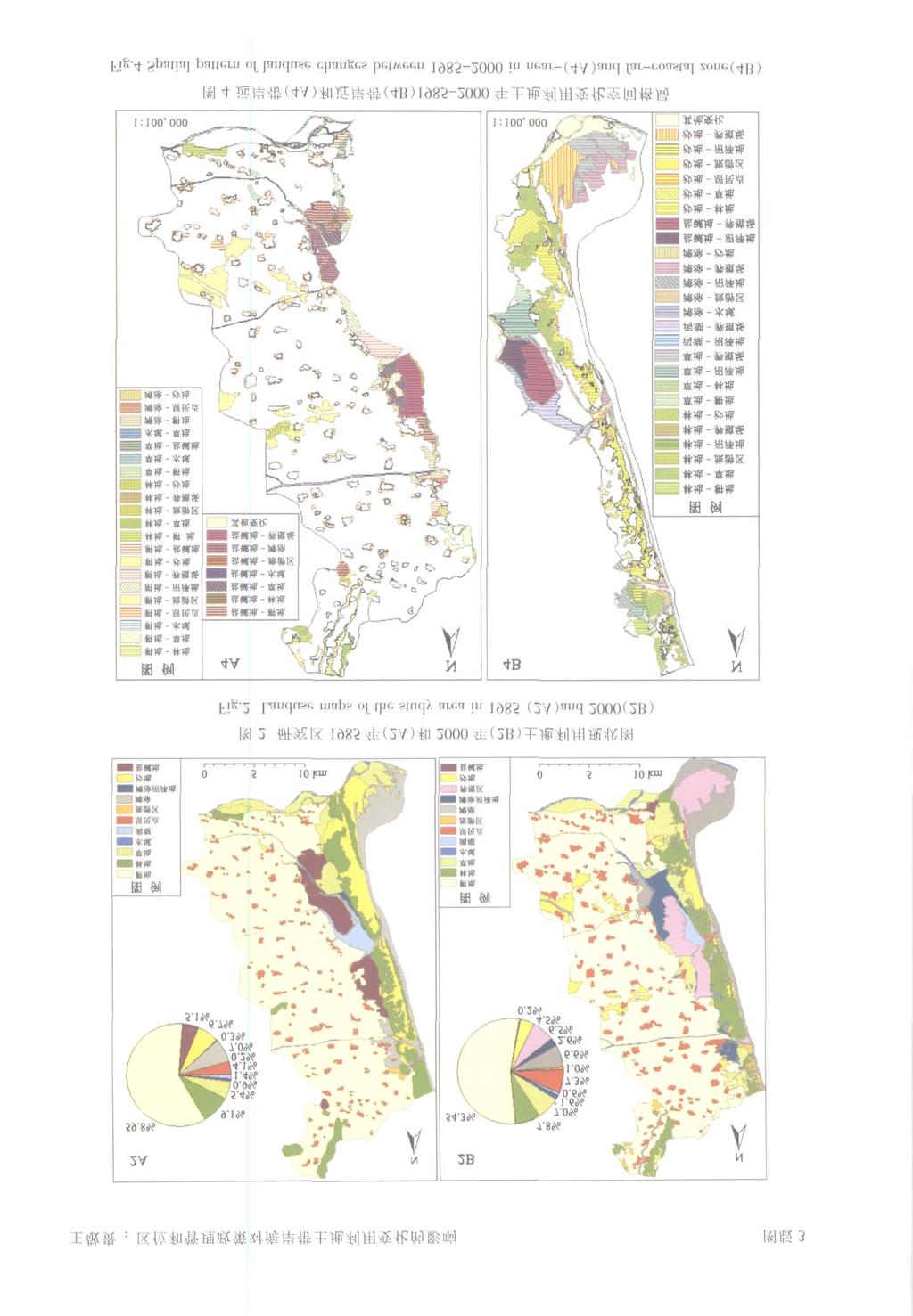
1 GEO GRA P HICAL RESEA RCH Vol124, No14 J uly, ,2, 1 3, 1, 1, 1, 1 (11, ; 21, ) : RS GIS ,,,,, ; : ; ; ; : (2005) ,, C2CA P Landsat TM SPO T HRV [1 ] ; L ACOAST, [2 ] L UCC, [3 11 ], [ 12 ], ; [11 ],, RS GIS, , ,,,, 10km,, : ; : : 863 (2003AA604040) (2004AA639820) : (19752),,, GIS 3 :, E2mail : ac1cn
![4 : 521 537127km 2 ( 1), ( ) ;, ;,,,,,,,, ;,, ;, 212 1 Fig11 Location of the study area [ 13 ] 1985 1984 5 1985 6 [ 14 ] (1](/docs-images/93/113199750/images/2-1.jpg "200000),,,, ( 1 50000) 2000 Land2 sat7 ETM + ( 2000 5 2 ) ( 2001 3 13 ),, 98 %,,, ; 3 311,, 15 ;,, ;, 15 35km 2 ;, ( 3, 2 1)")
2 4 : km 2 ( 1), ( ) ;, ;,,,,,,,, ;,, ;, Fig11 Location of the study area [ 13 ] [ 14 ] ( ),,,, ( ) 2000 Land2 sat7 ETM + ( ) ( ),, 98 %,,, ; 3 311,, 15 ;,, ;, 15 35km 2 ;, ( 3, 2 1) :,
3 ;,, ;, 1 ( : hm 2 ) Tab11 Areas of landuse types in the study area ( unit : hm 2 ) / ,, % ; 80 %, 2 3, 3 Fig13 Ratio of change types in near2and far2coastal zones ( %),, ; ( : hm 2 ) Tab12 Areas of main change types of landuse from 1985 to 2000 in near2coastal zone ( unit : hm 2 )
4 4 : ( : hm 2 ) Tab13 Areas of main change types of landuse from 1985 to 2000 in far2coastal zone ( unit : hm 2 ) ,, 4 ( 3),,,,, ;,,,,, 1985,,, 313,,, ;,,, ( 4),, ( 5), 1985 ( 3112km 2 ), 913km 2 ( 3, 2), ;,1985, ( : hm 2 ) Tab1 4 Areas of landuse types of protected area and development area in 1985 and 2000 ( unit : hm 2 )
5 Fig15 Ratio of change types in protected area and development area ( %) 14115km 2, ;,,, ( 5 3, 4) ( : hm 2 ) Tab15 Areas of main change types in protected area and development area ( unit : hm 2 ) % % % % : %,, 2000, ( ),,,, ( ) 1985, 2000,,, 12 km 2, ( 5 4) 1883, 20 km 2, km 2, km 2[15 ], km 2, km 2, 2000 (3146 km 2 ),,,, :,
6 4 : 525, 60 %, ( ) ;,,, 4 (1),, ;,, ; (2), ;, ;,, ; (3),, (4),, (5) ( ), 20 km km 2,, ( ) ( ) : [ 1 ] Dobson J E, Bright E A, Ferguson R L, et al1 NOAA Coastal Change Analysis Program (C2CAP) : Guidance for Regional Implementation1 NOAA Technical Report NMFS 123, [ 2 ] Loudjani P, et al1 The Lacoast project : land cover changes survey of European coastal zones1 In : Proceedings of Symposium on Operational Remote Sensing for Sustainable Development, Balkema, The Netherlands, [ 3 ],,, 1 1 D ( ),2004,34 (5) : [ 4 ],, 1 1,2001,56 (6) : [ 5 ] ,2001,16 (2) : [ 6 ],,, 1 1,2004,23 (2) : [ 7 ] 1 1,1997,16 (4) : [ 8 ],,, 1 1,2003,22 (6) : [ 9 ] Yeh, Ant hony Gar2on, Li Xia1 Economic development and agriculture land loss in t he Pearl River Delta, China1 Habitat Intl, 1999,23 (3) : [ 10 ],,, 1 1,2001,56 (3) : [ 11 ],, 1 1,2001,20 (6) : [ 12 ], 1-1,2004,13 (2) : ,2241 [ 13 ] Petit C C, Lambin E F1 Impact of data integration technique on historical land2use/ land2cover change : comparing historical maps wit h remote sensing data in t he Belgian Ardennes1 Landscape Ecology, 2002, 17 (2) : [ 14 ], 1 ( )1 [ 15 ] 1 1,1998, (2) :6 111
7 On effects of coastal location and management policy on landuse changes in coastal zone : a case study of Golden Coastal Region in Changli County WAN G Jing2gui, SU Fen2zhen, ZHOU Cheng2hu, YAN G Xiao2mei, DU Yun2yan, CH EN Xiu2fa ( Institute of Geographic Sciences and Natural Resources Research, CAS, Beijing , China) Abstract :The protection and rational use of coastal resources are keys to sustainable devel2 op ment in coastal zones, which are influenced by many nat ural and social factors such as coastal locatio n and management policies1 To realize sustainable develop ment of coastal zones, t he influence mechanism of impact factors on landuse changes must be st udied and rational policies are made based on the study1 To learn the effect s of coastal location and management policies of coastal zone on t heir landuse changes, as a case st udy, t he pattern of landuse changes f rom 1985 to 2000 in Golden Coastal Region of Changli county, Hebei p rovince was st udied in t his paper1 The landuse change in near2coastal and far2coastal zones shows t hat coastal location has great effect on landuse changes in coastal zone, and landuse change degree of near2coastal zone is greater than t hat of far2coastal zone and t heir main change types are different - t he main change types in near2coastal zone are t he con2 versio ns of beaches, lagoo ns, sand dunes, grasslands and farmlands into fishpo nds and sand dunes into grasslands and forestlands, while t he main change t ypes of far2coastal zo ne are the conversions of farmlands into rural residential areas and sand dunes, and saline2al2 kali lands into farmlands, fishpo nds and grasslands1 The co mpariso n of landuse changes between protected area and develop ment area, which are bot h in near2coastal zone, was made and t he result s prove that management policies of coastal zones have great effect s on landuse changes, too1 Landuse change degree in protected area is smaller than that of de2 velop ment area, and t he main change types in protected area are sand dunes into forest2 lands and grasslands and lagoon into fishponds, while t he main change types in develop2 ment area are affected by different develop ment policies, t he main change types of tourist area are forest into lands for to urism and recreatio n p urpo se and residential areas, and t hose of fishery cult ure area are grasslands and beaches into fishponds1 The analysis also shows t hat t he protected area has played it s positive roles in p rotection of lagoons, sand dunes and forest s after it s construction, but t he area of t he Qilihai lagoon is about 315km 2 now because of cultured fishponds around the lagoon before t he construction of protected area, therefore we must protect t he lagoon actively and forbid it s continuous cult uring and ret urn t he fishponds back to t he lagoon1 Key words :Golden Coast in Changli ; landuse change ; coastal locatio n ; management policy of coastal zone
8
GEO GRA P HICAL RESEA RCH
 27 3 2008 5 GEO GRA P HICAL RESEA RCH Vol127, No13 May, 2008 1, 1, 1, 2, 3 (11, 116029 ; 21, 100101) :,,,, Q,,, :,,,,, : ; ; ; : 100020585 (2008) 0320683210 1,,,,,, [ 1 ], P1 Evans,,,,,, [2 ] E1 Salzano,,,
GEO GRAPHICAL RESEARCH
 23 5 2004 3 GEO GRAPHICAL RESEARCH Vol123, No13 May, 2004,, (, 100101) :,, 1976 20,,,, GIS,,,, : ; ; ; : P737112 + 1 ; P33215 : 100020585 (2004) 0320339208 1 1855,,, 10, 7 [1 ] 1976 5,,,,,,,, [2 ],, [3
GEO GRA P HICAL RESEA RCH
 25 2 2006 3 GEO GRA P HICAL RESEA RCH Vol125, No12 Mar1, 2006 1,2, 1 (11, 100871 ; 21, 100084) : 1984 1999 Landsat TM,,,, 1984 1999,, : ; ; ; ; ; : 100020585 (2006) 0220204210 1, 1985 Batty [1 ], : Batty
GEO GRA P HICAL RESEA RCH
 25 2 2006 3 GEO GRA P HICAL RESEA RCH Vol125, No12 Mar1, 2006 (, 100101) :,, 50,,, 6 1986 1997,,,,,, 0162,,,,, : ; ; ; ; : 100020585 (2006) 0220276209 1, 20 80, [ 1 3 ] 20 70,,,,,,,,, [4 8 ] [9,10 ] [11
IMPACTS OF SEA LEVEL RISE in Bangkok, Thailand
 IMPACTS OF SEA LEVEL RISE in Bangkok, Thailand Hiroaki KAKIUCHI Chuo Mapping Co., Ltd Takekazu AKAGIRI, Takahito KUROKI, Tohru NAGAYAMA Geographic Survey Institute, Min. of Construction, JAPAN Shunji MURAI,
GEO GRA P HICAL RESEA RCH
 27 2 2008 3 GEO GRA P HICAL RESEA RCH Vol127, No12 Mar1, 2008 1,5, 1,6, 3, 2, 3, 4 (11, 100101 ; 21, 100101 ; 31, 210098 ; 41, 450004 ; 51, 100049 ; 61, 100081) : GL U E,, :, UM, (R 2 ), CS, R 2, B, R
Analysis of Industrialization, Urbanization and Land-use Change in East Asia According to the DPSER Framework
 1 Analysis of Industrialization, Urbanization and Land-use Change in East Asia According to the DPSER Framework Hidefumi IMURA*, Jin CHEN*, Shinji KANEKO** and Toru MATSUMOTO* * Institute of Environmental
An analysis on the relationship between land subsidence and floods at the Kujukuri Plain in Chiba Prefecture, Japan
 doi:10.5194/piahs-372-163-2015 Author(s) 2015. CC Attribution 3.0 License. An analysis on the relationship between land subsidence and floods at the Kujukuri Plain in Chiba Prefecture, Japan Y. Ito 1,
Applications of GIS and Remote Sensing for Analysis of Urban Heat Island
 Chuanxin Zhu Professor Peter V. August Professor Yeqiao Wang NRS 509 December 15, 2016 Applications of GIS and Remote Sensing for Analysis of Urban Heat Island Since the last century, the global mean surface
INTERNATIONAL JOURNAL OF GEOMATICS AND GEOSCIENCES Volume 2, No 1, 2011
 INTERNATIONAL JOURNAL OF GEOMATICS AND GEOSCIENCES Volume 2, No 1, 2011 Copyright 2010 All rights reserved Integrated Publishing services Research article ISSN 0976 4380 Spatio-Temporal changes of Land
Monitoring of Forest Cover Change in Sundarban mangrove forest using Remote sensing and GIS
 Monitoring of Forest Cover Change in Sundarban mangrove forest using Remote sensing and GIS By Mohammed Monirul Alam April 2008 Content 1: INTRODUCTION 2: OBJECTIVES 3: METHODOLOGY 4: RESULTS & DISCUSSION
A Comparison of the Social Valuation of Ecosystem Services in Urban and Rural Contexts
 A Comparison of the Social Valuation of Ecosystem Services in Urban and Rural Contexts Jarrod L. Loerzel College of Charleston Zachary D. Cole University of Florida Presentation Map 1. What is SolVES?
SIF_7.1_v2. Indicator. Measurement. What should the measurement tell us?
 Indicator 7 Area of natural and semi-natural habitat Measurement 7.1 Area of natural and semi-natural habitat What should the measurement tell us? Natural habitats are considered the land and water areas
APPLICATION OF REMOTE SENSING IN LAND USE CHANGE PATTERN IN DA NANG CITY, VIETNAM
 APPLICATION OF REMOTE SENSING IN LAND USE CHANGE PATTERN IN DA NANG CITY, VIETNAM Tran Thi An 1 and Vu Anh Tuan 2 1 Department of Geography - Danang University of Education 41 Le Duan, Danang, Vietnam
Applying GIS to Coastal Management in Cork Harbour: the Corepoint experience
 Applying GIS to Coastal Management in Cork Harbour: the Corepoint experience Kathrin Köpke University College Cork, Ireland Thematic Conference: THE WATERFRONT MANAGEMENT AND GI (IT), 14 th -18 th November
Con struction and applica tion of m odeling tendency of land type tran sition ba sed on spa tia l adjacency
 29 1 2009 1 ACTA ECOLOGICA SIN ICA Vol. 29, No. 1 Jan., 2009 1, 2, 3, 1, 3 (1., 250014; 2. ( ), 100083; 3., 100101) :,, 2000 2005,,,,, : ; ; ; : 100020933 (2009) 0120337207 : F323. 1, Q147, S126 : A Con
Relationship bet ween active components in Scutell a ria baica lensis and environmental factors in mounta inous region of Western Beijing
 Chinese Traditional and Herbal Drugs 40 8 2009 8 1291, 3,,,, (,,, 100875) :, 2007 89 8001 800 m 8 85, HPLC A ;,, ;,, ;, 26,, 3 4,, : ; ; ; ; :R2821 6 :A :025322670 (2009) 0821291206 Relationship bet ween
JOU RNAL OF DESERT RESEARCH
 29 2 2009 3 JOU RNAL OF DESERT RESEARCH Vol. 29 No. 2 Mar. 2009 :10002694X(2009) 0220370206 1, 2 (1.,, 100101 ; 2., 200240) :, ( Piper),,, ;,,;, ;, 32 a : ; ; ; : P641 : A,,,, 2,,,,,,, 2,,,,, 2,,,,,, [1-2
GEO GRA P HICAL RESEA RCH
 29 2 2010 2 GEO GRA P HICAL RESEA RCH Vol129, No12 Feb1, 2010, 3, (, 100101) :, (Multi2Parameter Sensitivity and Uncertainty Analysis, MPSUA) Monte Carlo, GL U E, MPSUA,,, MPSUA,, SCE2UA MPSUA, : ; ; ;
Ecological mapping using satellite imagery: an Abu Dhabi case study Middle East Geospatial Forum 16 th February 2015
 Ecological mapping using satellite imagery: an Abu Dhabi case study Middle East Geospatial Forum 16 th February 2015 Richard Flemmings rf@proteusgeo.com About Proteus Formed in UAE 2011 We specialise in
AN INTEGRATED MULTI-GOAL REGIONAL PLANNING PLATFORM BASED ON REMOTE SENSING AND GIS
 AN INTEGRATED MULTI-GOAL REGIONAL PLANNING PLATFORM BASED ON REMOTE SENSING AND GIS Xinhui Ma, Bingfang Wu *, Zhiming Luo, Lan Zeng Institute of Remote Sensing Applicat ions, Chinese Academy of Sciences,
CLLD Cooperation OFFER
 Title of the proposed project (English) CLLD Cooperation OFFER PARKS PROTECTION III - Management, Protection and Economic Development in Protected Areas Type of project (select as many as you want) Cooperation
PROMOTING NATURE CONSERVATION AND SUSTAINABLE AGRICULTURAL DEVELOPMENT IN THE RURAL AREAS OF HONG KONG
 1 PROMOTING NATURE CONSERVATION AND SUSTAINABLE AGRICULTURAL DEVELOPMENT IN THE RURAL AREAS OF HONG KONG Director of Agriculture, Fisheries and Conservation Dr. LEUNG Siu-fai A STONE S THROW AWAY FROM
Space Application in Support of Land Management for SDG Implementation
 Space Application in Support of Land Management for SDG Implementation Regional Expert Workshop on Land Accounting for SDG Monitoring and Reporting 26 September 2017 Space Application Section Information
Simulation of Wetlands Evolution Based on Markov-CA Model
 Simulation of Wetlands Evolution Based on Markov-CA Model ZHANG RONGQUN 1 ZHAI HUIQING 1 TANG CHENGJIE 2 MA SUHUA 2 1 Department of Geography informantion science, College of information and Electrical
Margarita Stancheva Hristo Stanchev & Robert Young 2. MEDCOAST JUBILEE WORKSHOP May 2015, Iberotel Sarigerme Park, Dalaman, Turkey
 Margarita Stancheva Hristo Stanchev & Robert Young 2 INTRODUCTION: Bulgarian Black Sea coast INTRODUCTION: Increasing pressure on Bulgarian coastal zone In 2011, of the 7 364 570 people that lived in Bulgaria,
TOWARDS STRATEGIC SPATIAL PLANNING IN JAMAICA: THE NATIONAL SPATIAL PLAN
 TOWARDS STRATEGIC SPATIAL PLANNING IN JAMAICA: THE NATIONAL SPATIAL PLAN JIEP 5th Biennial Conference on the Environment: Balancing National Development and Environmental Protection June 6, 2011 Jamaica
BURGAS CASE STUDY: LAND-SEA INTERACTIONS. Dr. Margarita Stancheva
 BURGAS CASE STUDY: LAND-SEA INTERACTIONS Dr. Margarita Stancheva Name of presentation NEED FOR COHERENCE BETWEEN LAND AND SEA ACTIVITIES Name presenter Burgas is the fourth largest city in Bulgaria and
Using Cellular Automaton to Simulate Urban Expansion in Changchun, China
 Sensors & Transducers 2014 by IFSA Publishing, S. L. http://www.sensorsportal.com Using Cellular Automaton to Simulate Urban Expansion in Changchun, China 1, 2 Jing MA, 3 Qiang BI, 4 Jingxia ZHANG, 1 Hongmei
An Internet-based Agricultural Land Use Trends Visualization System (AgLuT)
") An Internet-based Agricultural Land Use Trends Visualization System (AgLuT) Prepared for Missouri Department of Natural Resources Missouri Department of Conservation 07-01-2000-12-31-2001 Submitted by
An Internet-based Agricultural Land Use Trends Visualization System (AgLuT) Prepared for Missouri Department of Natural Resources Missouri Department of Conservation 07-01-2000-12-31-2001 Submitted by
CORRELATION BETWEEN URBAN HEAT ISLAND EFFECT AND THE THERMAL INERTIA USING ASTER DATA IN BEIJING, CHINA
 CORRELATION BETWEEN URBAN HEAT ISLAND EFFECT AND THE THERMAL INERTIA USING ASTER DATA IN BEIJING, CHINA Yurong CHEN a, *, Mingyi DU a, Rentao DONG b a School of Geomatics and Urban Information, Beijing
CORINE LAND COVER CROATIA
 CORINE LAND COVER CROATIA INTRO Primary condition in making decisions directed to land cover and natural resources management is presence of knowledge and high quality information about biosphere and its
Land cover/land use mapping and cha Mongolian plateau using remote sens. Title. Author(s) Bagan, Hasi; Yamagata, Yoshiki. Citation Japan.
 Bagan, Hasi; Yamagata, Yoshiki. Citation Japan.") Title Land cover/land use mapping and cha Mongolian plateau using remote sens Author(s) Bagan, Hasi; Yamagata, Yoshiki International Symposium on "The Imp Citation Region Specific Systems". 6 Nove Japan.
Title Land cover/land use mapping and cha Mongolian plateau using remote sens Author(s) Bagan, Hasi; Yamagata, Yoshiki International Symposium on "The Imp Citation Region Specific Systems". 6 Nove Japan.
Modeling and Predicting of Future Urban Growth in the Charleston, South Carolina Area
 Modeling and Predicting of Future Urban Growth in the Charleston, South Carolina Area Jeffery Allen Testimony presented to the U.S. Commission on Ocean Policy January 15, 2002 Charleston, South Carolina
Virginia Shoreline Mapping Tools
 Virginia Shoreline Mapping Tools December 15, 2017 Karen Duhring Center for Coastal Resources Management Virginia Institute of Marine Science College of William & Mary Virginia Shoreline Mapping Tools
The Governance of Land Use
 The planning system Levels of government and their responsibilities The Governance of Land Use COUNTRY FACT SHEET NORWAY Norway is a unitary state with three levels of government; the national level, 19
SPATIAL AND TEMPORAL MODELLING OF ECOSYSTEM SERVICES
 SPATIAL AND TEMPORAL MODELLING OF ECOSYSTEM SERVICES Solen Le Clec h, T.Decaëns, S. Dufour, M. Grimaldi, N. Jégou and J. Oszwald ACES Conference 2016 Jacksonville, Florida (USA). December, 5-9th : issues
Coastal Landuse Change Detection Using Remote Sensing Technique: Case Study in Banten Bay, West Java Island, Indonesia
 Kasetsart J. (Nat. Sci.) 39 : 159-164 (2005) Coastal Landuse Change Detection Using Remote Sensing Technique: Case Study in Banten Bay, West Java Island, Indonesia Puvadol Doydee ABSTRACT Various forms
Coastal Environment. Introduction. 4.1 Coastal Environment. Extent of Coastal Environment
 4 The primary objective (set out in Chapter 2) to be implemented by this Chapter is Objective 2.4 ; the following objectives are also relevant due to the objectives integrated nature: 2.1 Tāngata whenua
Coastal Vulnerability and Risk Parameters
 European Water 11/12: 3-7, 2005. 2005 E.W. Publications Coastal Vulnerability and Risk Parameters E. Doukakis National Technical University of Athens-Dept. of Rural and Surveying Engineering, Lab. of Higher
CHINESE GEOTOURISM AND GEOPARKS: SELECTED CASES
 CHINESE GEOTOURISM AND GEOPARKS: SELECTED CASES Global Eco Asia-Pacific Tourism Conference 2017, Adelaide 27-29 November, 2017 Dr Young Ng MH Geotourism Standing Committee, Geological Society of Australia
SPLAN-Natura Towards an integrated spatial planning approach for Natura th January, 2017 Brussels. Commissioned by DG Environment
 SPLAN-Natura 2000 Towards an integrated spatial planning approach for Natura 2000 Commissioned by DG Environment 17 th January, 2017 Brussels V. Simeonova (Ph.D.) Drivers towards integrating Biodiversity
Research Article Land Use Transformation Rule Analysis in Beijing-Tianjin-Tangshan Region Using Remote Sensing and GIS Technology
 Journal of Sensors Volume 2016, Article ID 6756295, 10 pages http://dx.doi.org/10.1155/2016/6756295 Research Article Land Use Transformation Rule Analysis in -- Region Using Remote Sensing and GIS Technology
INSTITUTE OF TOWN PLANNERS, INDIA TOWN PLANNING EXAMINATION BOARD ASSOCIATESHIP EXAMINATION
 SUBJECT: C.1.1. Planning Theory Maximum Marks: 20 1. What is Rational Planning Model? Discuss its main features. 2. Discuss the salient features of Advocacy Planning Theory. 3. Discuss David Harvey s contribution
Urban Sprawl Mapping and Landuse Change Detection in and around Udupi Town: A Remote Sensing based Approach
 Urban Sprawl Mapping and Landuse Change Detection in and around Udupi Town: A Remote Sensing based Approach 1 K. Silambarasan, 2 M. S. Vinaya, 3 S. Suresh Babu 1,2,3 Department of Civil Engineering, 1,2,3
Study of Land Use and Land Cover of Chaksu block, Jaipur through Remote Sensing and GIS
 Study of Land Use and Land Cover of Chaksu block, Jaipur through Remote Sensing and GIS Ruchi Middha *, Sonal Jain* and Shelja K.Juneja ** *RESEARCH SCHOLAR, ENVIRONMENTAL SCIENCE, THE IIS UNIVERSITY,
Abstract 1. The challenges facing Cartography in the new era.
 Geo-Informatic Tupu the New development of Cartography Qin Jianxin Ph. D. The Research Center of Geographic Information System (GIS), Hunan Normal University. Changsha, Hunan, 410081 E-Mail: qjxzxd@sina.com
GRASS COVER CHANGE MODEL BASED ON CELLULAR AUTOMATA
 GRASS COVER CHANGE MODEL BASED ON CELLULAR AUTOMATA Shuai Zhang *, Jingyin Zhao, Linyi Li Digital Agricultural Engineering Technological Research Center, Shanghai Academy of Agricultural Sciences, Shanghai,
URBAN LAND PLANNING AND CHANGE DETECTION USING SATELLITE IMAGES (CASE STUDY: ANZALI WETLAND WATERSHED)
") URBAN LAND PLANNING AND CHANGE DETECTION USING SATELLITE IMAGES (CASE STUDY: ANZALI WETLAND WATERSHED) Borhan Riazi, Seyed Masoud Monavari, * Ali Bali, Nematollah Khorasani and Mir Masoud Kheirkhah Zarkesh
URBAN LAND PLANNING AND CHANGE DETECTION USING SATELLITE IMAGES (CASE STUDY: ANZALI WETLAND WATERSHED) Borhan Riazi, Seyed Masoud Monavari, * Ali Bali, Nematollah Khorasani and Mir Masoud Kheirkhah Zarkesh
Land Use Modelling for Environmental and Ecological Policy Assessment:
 Judith Borsboom Land Use Modelling for Environmental and Ecological Policy Assessment: Sustainable Netherlands Study in collaboration with: Wageningen University & Research centre WL Delft Hydraulics Arcadis
Overview of LEDDRA. Three years of research on responses to LEDD
 Overview of LEDDRA Three years of research on responses to LEDD, Coordinating institution (Greece) Project partners Agricultural University of Athens (Greece) 3D-Environmental Change (The Netherlands)
Research Article Spatiotemporal Simulation of Tourist Town Growth Based on the Cellular Automata Model: The Case of Sanpo Town in Hebei Province
 Abstract and Applied Analysis Volume 2013, Article ID 975359, 7 pages http://dx.doi.org/10.1155/2013/975359 Research Article Spatiotemporal Simulation of Tourist Town Growth Based on the Cellular Automata
THE DESIGN AND IMPLEMENTATION OF A WEB SERVICES-BASED APPLICATION FRAMEWORK FOR SEA SURFACE TEMPERATURE INFORMATION
 THE DESIGN AND IMPLEMENTATION OF A WEB SERVICES-BASED APPLICATION FRAMEWORK FOR SEA SURFACE TEMPERATURE INFORMATION HE Ya-wen a,b,c, SU Fen-zhen a, DU Yun-yan a, Xiao Ru-lin a,c, Sun Xiaodan d a. Institute
PROGRESS IN GEOGRAPHY
 28 1 2009 01 PROGRESS IN GEOGRAPHY Vol.28, No.1 Jan., 2009 (1., 550001; 2., 400047; 3., 550025) : 1976 MSS,1986 1996 TM,2006 CBERS 1 5 DEM,, 30m ;, ;,,, 5~15km, : ; ; 1,,, [16],,, R.Welch 30 TM, GIS, [1],,,
CBD CBD GEO GRA P HICAL RESEA RCH. 2001, CBD (Central Business District, ) CBD, Vol127, No13 May, 2008 CBD : (2008) : (05CJ Y017)
 CBD, Vol127, No13 May, 2008 CBD : (2008) : (05CJ Y017)") 27 3 2008 5 GEO GRA P HICAL RESEA RCH Vol127, No13 May, 2008 CBD CBD 1, 1, 1,2 3 (11, 310027 ; 21, 310027) : CBD, CBD, CBD,,, 1 (A ) 4 (B ) 18 (C ) CBD, 32,,,, CBD B3 (01 4085) B4 (013392), CBD, : CBD
27 3 2008 5 GEO GRA P HICAL RESEA RCH Vol127, No13 May, 2008 CBD CBD 1, 1, 1,2 3 (11, 310027 ; 21, 310027) : CBD, CBD, CBD,,, 1 (A ) 4 (B ) 18 (C ) CBD, 32,,,, CBD B3 (01 4085) B4 (013392), CBD, : CBD
INTERNATIONAL JOURNAL OF GEOMATICS AND GEOSCIENCES Volume 4, No 2, 2013
 INTERNATIONAL JOURNAL OF GEOMATICS AND GEOSCIENCES Volume 4, No 2, 2013 Copyright 2010 All rights reserved Integrated Publishing services Research article ISSN 0976 4380 Evaluation of landuse / landcover
Study on Gra ssland Re source Changing Trend of Farm2Herd Intervein Zone in We stern Jilin Province
 2005,27 (1) :86 91 Journal of Jilin Agricultural University Ξ 1, 1, 1, 2, 1 (1., 130026 ; 2., 130026) :,, 1989 2001 :12 22168 hm 2,1175 %,,,, : ; ; ; ; : S81218 : A : 100025684 (2005) 0120086206 Study
CAMP SLOVENIA. Mezek Slavko RRC Koper. Project coordinator November 2005
 CAMP SLOVENIA Mezek Slavko RRC Koper Project coordinator November 2005 http://camp.rrc-kp.si/ Content About MAP CAMP programme CAMP Slovenia Project background CAMP Slovenia Project area CAMP Slovenia
2008, hm 2. ( Commodity Bundle) [ 6], 25 4 Vol. 25 No JOURNAL OF NATURAL RESOURCES Apr., , 2, 3, 1, 2 3*,
![2008, hm 2. ( Commodity Bundle) [ 6], 25 4 Vol. 25 No JOURNAL OF NATURAL RESOURCES Apr., , 2, 3, 1, 2 3*,](/thumbs/93/112700429.jpg "2008, hm 2. ( Commodity Bundle) [ 6], 25 4 Vol. 25 No JOURNAL OF NATURAL RESOURCES Apr., , 2, 3, 1, 2 3*,") 25 4 Vol. 25 No. 4 2010 4 JOURNAL OF NATURAL RESOURCES Apr., 2010 1, 2, 3, 3*, 3, 3, 1, 2 ( 1., 100101; 2., 100049; 3., 100193) :,,,,, ;, 2005, 12 7 5, 2005 :,,, : ; ; ; ; : F301. 21 : A : 1000-3037( 2010)
25 4 Vol. 25 No. 4 2010 4 JOURNAL OF NATURAL RESOURCES Apr., 2010 1, 2, 3, 3*, 3, 3, 1, 2 ( 1., 100101; 2., 100049; 3., 100193) :,,,,, ;, 2005, 12 7 5, 2005 :,,, : ; ; ; ; : F301. 21 : A : 1000-3037( 2010)
Remote Sensing for Ecosystems
 MODULE GUIDE MSc ENR Remote Sensing for Ecosystems Semester 01 Modul coordinator Lecturers Michael Döring Pascal Ochsner, Diego Tonolla, Diane Whited, Michael Döring Martin Geilhausen Latest update August
GEO GRA P HICAL RESEA RCH
 26 4 2007 7 GEO GRA P HICAL RESEA RCH Vol126, No14 J uly, 2007 1,2, 1, 3, 1, 1 (11, 100101 ; 21, 100053) :,, DISORT,, LibRadtran UVSPEC GIS 2000 1 7,,, 2000 1 7, 1, 7 UVA UVB, 7, UVB UVA UVB UVA 6 : ;
1. Introduction. Chaithanya, V.V. 1, Binoy, B.V. 2, Vinod, T.R. 2. Publication Date: 8 April DOI: https://doi.org/ /cloud.ijarsg.
 Cloud Publications International Journal of Advanced Remote Sensing and GIS 2017, Volume 6, Issue 1, pp. 2088-2096 ISSN 2320 0243, Crossref: 10.23953/cloud.ijarsg.112 Research Article Open Access Estimation
Beijing, China. *Corresponding author
 2016 Joint International Conference on Economics and Management Engineering (ICEME 2016) and International Conference on Economics and Business Management (EBM 2016) ISBN: 978-1-60595-365-6 The Utilization
CK107 BA in Geographical and Archaeological Sciences
 CK107 BA in Geographical and Archaeological Sciences CK107 BA in Geographical and Archaeological Science Geography and Archaeology are closely related disciplines, concerned with concepts of time and space
Carpathians Unite mechanism of consultation and cooperation for implementation of the Carpathian Convention
 Carpathians Unite mechanism of consultation and cooperation for implementation of the Carpathian Convention Zbigniew Niewiadomski, UNEP/GRID-Warsaw Centre First Joint Meeting of the Carpathian Convention
GEO GRA P HICAL RESEARCH
 29 5 2010 5 GEO GRA P HICAL RESEARCH Vol129, No15 May, 2010 1, 1 3, 2 (11, 310027 ; 21 ( ), 518034) :,,,,, 700 m, 1915 % 100 m, 371 8 %,,, : ; ; : 100020585 (2010) 0520801210 1, 1863,,,,, ;,,,,,,,,,, 2,
Annotated Bibliography. GIS/RS Assessment of Desertification
 David Hussong NRS 509 12/14/2017 Annotated Bibliography GIS/RS Assessment of Desertification Desertification is one of the greatest environmental challenges of the modern era. The United Nations Conference
16540/14 EE/cm 1 DG E 1A
 Council of the European Union Brussels, 5 December 2014 (OR. en) 16540/14 ENV 965 CULT 139 NOTE From: To: Subject: General Secretariat of the Council Delegations Charter of Rome on Natural and Cultural
Coastal Guide ICZM Information System
 Coastal Guide ICZM Information System 1. Key data Project title: Implementing alternative strategies in Irish beach and dune management: involvement in sustainable coastal development Country: Ireland
Tuition, Medical and Behaviour Support Service
 Tuition, Medical and Behaviour Support Service Curriculum Policy - Primary Geography Reviewed: October 2018 Next Review: October 2019 Responsibility: Andrea Snow AIMS AND PRINCIPLES The national curriculum
European Landscape Convention in the Slovak Republic
 13th COUNCIL OF EUROPE MEETING OF THE WORKSHOPS FOR THE EUROPEAN LANDSCAPE CONVENTION European Landscape Convention in the Slovak Republic Mrs. Ida Vanáková, state advisor, Department of Spatial Planning
Land Use Change Patterns and Sustainable Urban Development in China
 Land Use Change Patterns and Sustainable Urban Development in China Haiyan Zhang* 1, Michinori Uwasu 2, Keishiro Hara 3 and Helmut Yabar 2 1 Research Fellow, Research Institute for Sustainability Science,
GIS and Remote Sensing
 Spring School Land use and the vulnerability of socio-ecosystems to climate change: remote sensing and modelling techniques GIS and Remote Sensing Katerina Tzavella Project Researcher PhD candidate Technology
Navigable maritime and river waterways in the seaside - Danube Delta area and the connected rural development
 SUMMARY OF Ph-D Thesis, with title RESEARCH STUDIES ON MANAGEMENT IMPROVEMENT OF MARITIME AND RIVER TRANSPORT ACTIVITY IN THE COASTAL AND DANUBE DELTA AREA FROM AN ENVIROMENTAL, ECONOMIC AND SOCIAL PERSPECTIVE
Department of Geography: Vivekananda College for Women. Barisha, Kolkata-8. Syllabus of Post graduate Course in Geography
 India: Regional Problems and Resource management Module 11 (Full Marks 50) Unit I: Region and Regionalisation 1.1 Various bases of regionalisation of India; problems of identification and delineation.
Dynamical Monitoring and Evaluation Methods to Urban Heat Island Effects Based on RS&GIS
 Available online at www.sciencedirect.com Procedia Environmental Sciences 10 (2011 ) 1228 1237 Procedia 2011 Environmental 3rd International Sciences 00 Conference (2011) 000 000 on Environmental Science
Dataset of Classification and Land Use of the Ecological Core Areas of China
 Journal of Global Change Data & Discovery. 2017, 1(4):426-430 DOI:10.3974/geodp.2017.04.07 www.geodoi.ac.cn 2017 GCdataPR Global Change Research Data Publishing & Repository Dataset of Classification and
THE MODEL OF SPATIAL ORGANIZATION OF COASTAL FISHERMEN VILLAGES IN THE SOUTH CENTRAL COAST OF VIETNAM
 i MINISTRY OF EDUCATION AND TRAINING MINISTRY OF CONSTRUCTION HANOI ARCHITECTURAL UNIVERSITY TRAN VAN HIEN THE MODEL OF SPATIAL ORGANIZATION OF COASTAL FISHERMEN VILLAGES IN THE SOUTH CENTRAL COAST OF
INDIANA ACADEMIC STANDARDS FOR SOCIAL STUDIES, WORLD GEOGRAPHY. PAGE(S) WHERE TAUGHT (If submission is not a book, cite appropriate location(s))
 WHERE TAUGHT (If submission is not a book, cite appropriate location(s))") Prentice Hall: The Cultural Landscape, An Introduction to Human Geography 2002 Indiana Academic Standards for Social Studies, World Geography (Grades 9-12) STANDARD 1: THE WORLD IN SPATIAL TERMS Students
Prentice Hall: The Cultural Landscape, An Introduction to Human Geography 2002 Indiana Academic Standards for Social Studies, World Geography (Grades 9-12) STANDARD 1: THE WORLD IN SPATIAL TERMS Students
Sustainable development of the Greek islands
 Sustainable development of the Greek islands Coccossis H. in Camarda D. (ed.), Grassini L. (ed.). Interdependency between agriculture and urbanization: Conflicts on sustainable use of soil and water Bari
GEO GRA P HICAL RESEA RCH
 24 5 2005 9 GEO GRA P HICAL RESEA RCH Vol124, No15 Sept1, 2005 1, 2,3, 1,2, 1, 1, 1 (11, 100080 ; 21, 100101 ; 31, 100101) :,,,, 6193 10 9 m 3 / a, 41319 m 3 / a, 471 6 % 431 4 % 910 %,,,,,, : ; ; ; :
Urban Studies Applicable to students admitted in
 Urban Studies Applicable to students admitted in 2014-15 Major Programme Requirement Students are required to complete a minimum of 8 units of courses as follows: 1. Faculty Package: 9 Any three courses,
I&CLC2000 in support to new policy initiatives (INSPIRE, GMES,..)
") I&CLC2000 in support to new policy initiatives (INSPIRE, GMES,..) Manfred Grasserbauer, Director Joint Research Centre Institute for Environment and Sustainability 1 IMAGE 2000 European mosaic of satellite
I&CLC2000 in support to new policy initiatives (INSPIRE, GMES,..) Manfred Grasserbauer, Director Joint Research Centre Institute for Environment and Sustainability 1 IMAGE 2000 European mosaic of satellite
CHAPTER 11 USE OF MIDRESOLUTION LAND COVER DATA FOR RAPID COMPARISON OF COMMUNITY VULNERABILITY TO TSUNAMIS. Nathan Wood
 CHAPTER 11 USE OF MIDRESOLUTION LAND COVER DATA FOR RAPID COMPARISON OF COMMUNITY VULNERABILITY TO TSUNAMIS Nathan Wood Western Geographic Science Center, U.S. Geological Survey, Vancouver, WA 98683 ABSTRACT
ECONOMIC IMPACTS OF GEOTOURISM AND GEOPARKS IN CHINA
 ECONOMIC IMPACTS OF GEOTOURISM AND GEOPARKS IN CHINA Global Eco Asia-Pacific Conference 2017, Adelaide 27-29 November, 2017 Dr Young Ng MH Geotourism Standing Committee, Geological Society of Australia
, Horton , km Tsinghua Tongfang Optical Disc Co., Ltd. All rights reserved. Vol. 21, No. 2 GEO GRAPHICAL RESEARCH
 21 2 2002 3 Vol. 21, No. 2 GEO GRAPHICAL RESEARCH Mar., 2002 : 100020585 (2002) 0220171208 (, 100101) :, 50 500 2500, 6 15,,,,,, : ; ; : P93111 ; P33314 : A, [1, Horton 1942 ], [2 10, ],,,,,,,,,,,,,, 50
BURGAS CASE STUDY: LAND-SEA INTERACTIONS
 BURGAS CASE STUDY: LAND-SEA INTERACTIONS Dr. Margarita Stancheva IO-BAS, Bulgaria Name of presentation CROSS BORDER MARITIME SPATIAL PLANNING IN THE BLACK SEA ROMANIA AND BULGARIA (MARSPLAN BS) Project
Marine Spatial Planning Leslie-Ann McGee Battelle Memorial Institute
 Marine Spatial Planning Leslie-Ann McGee Battelle Memorial Institute Rev061708 1 Marine Spatial Planning What is it? Why is it different? Where is it currently being employed? What is happening in the
Geospatial technology for land cover analysis
 Home Articles Application Environment & Climate Conservation & monitoring Published in : Middle East & Africa Geospatial Digest November 2013 Lemenkova Polina Charles University in Prague, Faculty of Science,
The international patterns of spatial planning system and choice of China. Cai yumei China land use planning and surveying institute (China, beijing)
") FIG Working Week, Rome, Italy 6 10 May 2012 The international patterns of spatial system and choice of China Cai yumei China land use and surveying institute (China, beijing) Outline Background Problem
FIG Working Week, Rome, Italy 6 10 May 2012 The international patterns of spatial system and choice of China Cai yumei China land use and surveying institute (China, beijing) Outline Background Problem
USING GIS FOR DEVELOPING SUSTAINABLE URBAN GROWTH CASE KYRENIA REGION
 USING GIS FOR DEVELOPING SUSTAINABLE URBAN GROWTH CASE KYRENIA REGION Can Kara 1,* Nuhcan Akçit 2, * 1 Nearest University, Nicosia, Faculty of Architecture, Nicosia Cyprus, Email: can.kara@neu.edu.tr 2
Sri Lanka has a coastline of km excluding the shoreline of bays and inlets.
 Defining and Demarcating Coastal zones in Sri Lanka Procedure, Challenges and What needs to be done? Dr. Anil Premaratne Director General Coast Conservation Coast Conservation Department Sri Lanka 1 Sri
A Spatial Decision Support System for Agriculture and Natural Resources Management in China
 9 th APGEOSS Symposium Xiangzheng Deng A Spatial Decision Support System for Agriculture and Natural Resources Management in China Need to take decisions and make critical day-to-day and long-term planning
Sustainable Cities and Communities based on Indicators on Urbanization 地理国情监测技术. Prof. Dr. John W. Z. SHI The Hong Kong Polytechnic University
 IAEG- SDGs WG on Geospatial Information, 1 st Expert Group Meeting 12-14 Dec 2016 Mexico City Measure 地理国情监测技术 Sustainable Cities and Communities 专业 based on Indicators on Urbanization Prof. Dr. John W.
System of Environmental-Economic Accounting. Advancing the SEEA Experimental Ecosystem Accounting. Extent Account (Levels 1 and 2)
") Advancing the SEEA Experimental Ecosystem Accounting Extent Account (Levels 1 and 2) Overview: The Extent Account 1. Learning objectives 2. Review of Level 0 (5m) What is it? Why do we need it? What does
Advancing the SEEA Experimental Ecosystem Accounting Extent Account (Levels 1 and 2) Overview: The Extent Account 1. Learning objectives 2. Review of Level 0 (5m) What is it? Why do we need it? What does
Land Use in the context of sustainable, smart and inclusive growth
 Land Use in the context of sustainable, smart and inclusive growth François Salgé Ministry of sustainable development France facilitator EUROGI vice president AFIGéO board member 1 Introduction e-content+
A Level Geography Cambridge International Content Programme For teaching from September 2016
 A Level Geography Cambridge International Content Programme For teaching from September 2016 is located on the Start Bay coast in South Devon and is surrounded by Slapton Ley National Nature Reserve. The
Using Landsat Imagery to Model Increasing Habitat Fragmentation and Its Effects on Tree Migration Abstract
 Using Landsat Imagery to Model Increasing Habitat Fragmentation and Its Effects on Tree Migration Abstract Numerous models, such as that by Iverson and Prasad (1998), have been developed to investigate
RECOMMENDED STUDY PLAN 2018
 RECOMMENDED STUDY PLAN 2018 NAME DEGREE PROGRAM Master of Science STUDENT NUMBER MAJOR Trop Bio & Con-TSV (MSC-TBI) Level 5: Year 1 SP3 SP1 SP6/7 SP2 SP10/SP11 Major Core: BZ5215 Major Opt Skill Conservation
Geography Policy. for Hertsmere Jewish Primary School
 Geography Policy for Hertsmere Jewish Primary School Reviewed by: L Rubin Reviewed on: September 2017 Date of Next Review: September 2018 Policy Review This policy will be reviewed in full by the Governing