A Spatial Decision Support System for Agriculture and Natural Resources Management in China
|
|
|
- Matthew Elliott
- 5 years ago
- Views:
Transcription
1 9 th APGEOSS Symposium Xiangzheng Deng A Spatial Decision Support System for Agriculture and Natural Resources Management in China Need to take decisions and make critical day-to-day and long-term planning on agricultural and natural resource management (strategic and tactical). Supports have to be relevant, timely, user-friendly to assist and manage crop cultivation. Decision Support System(DSS) offers scientific-technical tools to combine skills and experience.
2 Outline of this talk Background Framework An application Development prospect


3 As we all know, compared to geographical factors, anthropogenic factors need to be paid more attention with Agricultural condition monitoring system Meteorological and hydrological monitoring and forecasting system Climate Floods in Mexico Supper Typhoon Land Geoenvironment System Human Human domains It is difficult to provide timely and effective decision support for agriculture and natural resources management due to the lagged behind observation of human dimensions.
4 Categories of natural resources closely linked with agriculture Land resource Water resource Genetic resource DSS related Energy resource Climate resource Human resource Economic resource
5 Decision Support System(DSS) while used in agricultural and natural resource management, DSS is with specific features: Aim at promoting areas of agriculture and natural resources management of all disciplines; A comprehensive collection to disseminate knowledge and information on these fields; A platform with the debate and dissemination of the research fields and directions with practical applications.
 to natural (e.")
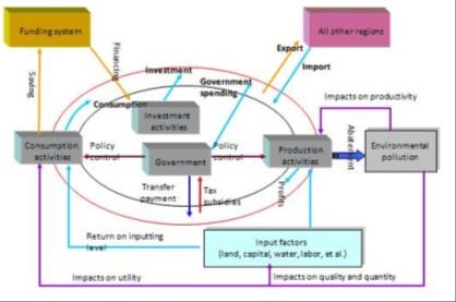
6 Decision Support System(DSS) A coupled human environment system. It is an integrated scientific framework for studying the interface and reciprocal interactions that link human (e.g., economic, social) to natural (e.g., hydrologic, atmospheric, biological) sub-systems of the system.
7 Outline of this talk Background Framework An application Development prospect
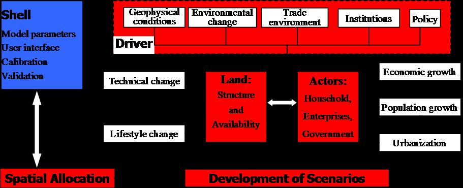
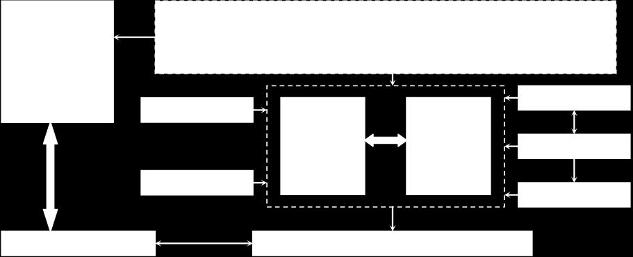
8 Framework of a Spatial Decision Support System Planning Decision making Simulation platform Communication Forecast for future Model base (library) Scenarios Typical scenarios Geographic Database Scenarios Data analysis Technical support Knowledge base (Experts knowledge)

9 Design of a Spatial Decision Support System End User Researc her Software Engineer Adaptive and integrative tools and strategies for natural resources management; The outcome of the project should be a tool-box for integrated agriculture and natural resources; The expected impact is a longterm integrated management of natural resources.
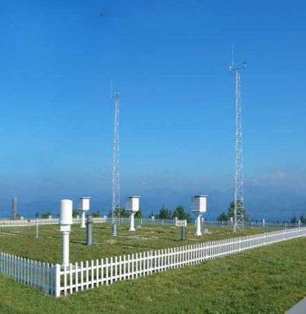
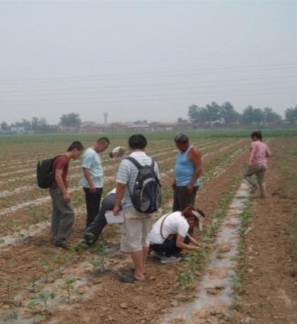
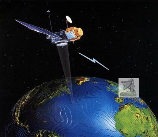
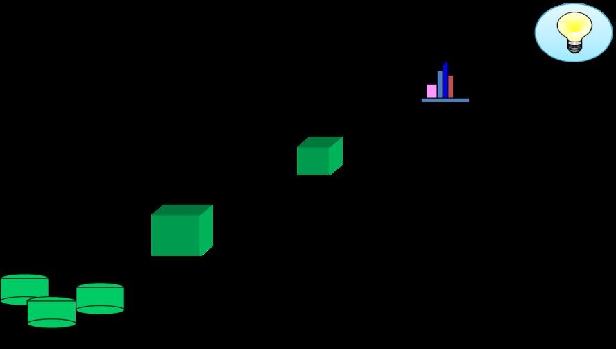
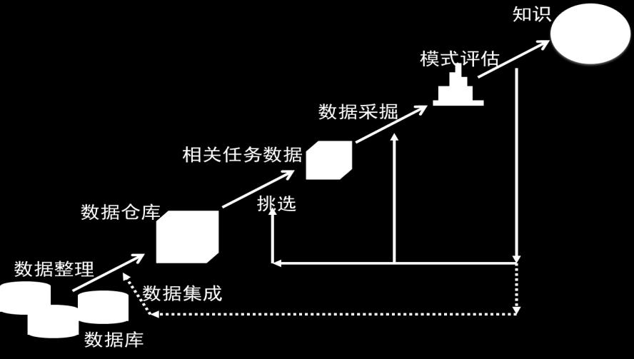
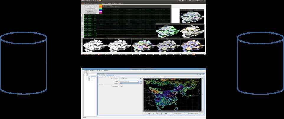

10 Data collection/handling Six approaches Remote sensing Field monitoring Field survey Historical data Data mining Model Simulation

11 Prediction of the outcomes along with the scenario-based development paths
12 Final outputs of DSS...to deliver: Guidance document Toolbox Training course(modules) Policy briefs Publications
13 Toolbox of DSS Database with tools + standard Several keys to find tools in the database Wizard, queries,.. Interaction with online guidance Possibility to add tools, cases,..
14 Outline of this talk Background Framework An application Development prospect

15 An Application in Yunnan province A spatial decision support system provides suggestions for the sloping land development in Yunnan province Typical scenarios generator Key policy-based parameters extraction and quantification Development strategy Scenarios Decision support system Evolution platform I I I Medium to simulate warning e.g. grain import price (dollar/ton) + S F S F S F Coefficients and parameter Key stock and variation in discharge


16 An application in Yunnan Province Decision support platform for the agricultural development as well as the vulnerability of natural disasters

17 Case study in Yunnan Province Altitudes up to 2000 meters; Reserved land resources are mostly located in the mountains, where altitude is lower than 2500 m while with steep slope. Mountain Hill Mesa Plain Plateau DEM Slope Total area of Yunnan is about 390 thousands km 2. Mountains and plateaus cover 94% of the total area.

18 Local characteristics Rapid expansion of built-up area exert great effects on: low natural and ecosystem carrying capacity, water loss and soil erosion, surface runoff. Legend Legend


19 Local characteristics Spatial heterogeneity of the air temperature at 2m above the ground in Yunnan province during (Unit: ) Spatial pattern of the risk of drought in Yunnan province during Spatial heterogeneity of precipitation in Yunnan province during (Unit: mm) Time-series data suggests the temperature of the same place will steadily increase by 0.5 /10 years; Precipitation in the northwest part will show a first decreasing and then increasing trend, first reaching 2850mm in year 2020, then declining to 2650mm in year 2030.
20 Challenges Lack of the geological hazard/ecological monitoring network Incomplete monitoring indicator system Weak capability of disaster monitoring Remote-sensing based monitoring network Lagged behind identification of risk threshold
21 Key research tasks In-site monitoring of geological hazards of mountain development Ecological environment back ground data of the research area In-site monitoring of environment of mountain development Real time database of the ecological risk and geological hazards monitoring Geological hazards process simulation Evaluation method of the implementation of land use planning Building extraction of remote sensing image analysis Ecological risk assessment model Geological hazards and ecological risk monitoring of low hilly mountain Land use regulation measure and suggestion for low hilly mountain development Build up agricultural and natural database for early warning geological hazard Design models, calibration, validation and efficiency evaluation of models Extract key parameters for improving models, analyze thresholds of the simulated system Integrate systematic analysis for agriculture development and natural disaster relief
22 Work package #1 Collect spatial data of agriculture and nature disaster risk etc. Select the demonstration area and build the GPS observation net to monitor adjustment and displacement Lay automatic sensor equipment Develop the monitoring database of agriculture and nature disaster relief based on memory access technology Select indicating index of geological hazards type and ecological risk Fundamental data (ecological, meteorological, topological, etc.) Analysis on present situation and characteristics of geological hazards and ecological risk Set GPS displacement observation net Real-time transformation of data and remote monitoring Monitoring data of balancing and displacement fall, displacement, gradient) Data processing and analysis Remote sensing data Monitoring database of geological hazards and ecological risk
23 Work package #2 Historical geologic hazards distribution Frequency figure of assessment of geologic hazards Real-time transformation Ecological monitoring site layout distribution of climate factors process simulation of geologic hazards formation spatial interpolation LUCC Landform structure superimposed calculating Regional hydrologi cal factors Ecological parameters monitoring Simulation of ecohydrological process administrativ e boundaries spatial distribution of risk warning geologic hazards warning map spatial analysis Run-off depth Erosion modulus research on assessment model of geologic hazards warning and ecological risk Ecological risk assessment Select and explore the project area(low hilly mountain of Dali city) Collect meteorological, hydrological, land cover and land use, and topography data to build risk model Explore the mechanism of occurrence of geological hazards, prepare parameters for RA(Rockfall Analyst) simulation,launch geological disaster process simulation
24 Work package #3 Research on remote sensing image analysis algorithm, build extraction technique based on high resolution remote sensing image Determine warning threshold of key index of natural disasters and agricultural risks Develop warning and monitoring system of natural disaster risk and agricultural development Real-time monitoring database Threshold of key parameters and expert evaluation system Mechanism exploration and simulation results analysis Assessment indicators Geologic hazards and ecological risk Index weight based on expert evaluation Geologic hazards and ecological risk assessment model Analytic Hierarchy Process Fuzzy comprehensive evaluation method Ecological risk warning index system of the low hilly mountain development Spatial analysis of land use planning implemented by remote sensing image analysis Geologic hazards and ecological risk warning monitoring system of the low hilly mountain development
25 Work package #4 Select the constrain index of ecological sustainability, quantize the standard of land use planning and agricultural land use Research on evaluation model and technical method of implementation of land use planning and natural resource management Evaluate the implementation effect comprehensively, provide regulating measures and suggestions for the optimization of land use Monitoring data base of the geologic hazards caused by the implementation Spatial analysis method Ecological and economic benefits evaluation of mountain development Statistical data of the socio-economic data of Dali city Land use planning of the Dali city mountain development Multi index evaluation Model and method for the evaluation of land use planning of low hilly mountain development Industrial land use survey Industrial land use of mountain development standard Land use planning assessment and optimization suggestion of Dali low hilly mountain development
26 Work package #5 Selection and monitoring key parameters of land use planning for natural disaster relief and agricultural development Natural disaster relief and agricultural development for the region with low mountains and hills of mild slope Thresholds of key parameters of natural disaster relief and agricultural development in the region with low mountains and hills of mild slope Land use planning and risk assessment in mountainous area and regional optimal land use planning and measurement


: 552-576. Deng, X., Z. Li, J. Gibson, 2016.")
27 Deng, X., J. Gibson, P. Wang, Relationship between landscape diversity and crop production: a case study in the Hebei Province of China based on multi-source data integration, Journal of Cleaner Production, Volume 142, Part 2, Deng, X., J. Gibson, P. Wang, Management of trade-offs between cultivated land conversions and land productivity in Shandong Province, Journal of Cleaner Production, Volume 142, Part 2, Pages Deng, X., J. Gibson, P. Wang, Quantitative measurements of the interaction between net primary productivity and livestock production in Qinghai Province based on data fusion technique, Journal of Cleaner Production, Volume 142, Part 2, Pages Deng, X., Z. Wang, C. Zhao, Economic Evolution in China Ecologically Fragile Regions Journal of Economic Surveys, 30(3): Deng, X., Z. Li, J. Gibson, A review on trade-off analysis of ecosystem services for sustainable land-use management, Journal of Geographical Sciences, 26(7): Deng, X., J. Huang, S. Rozelle, et al., Impact of urbanization on cultivated land changes in China. Land Use Policy. 45, 1 7. Deng, X., X. Bai, Sustainable urbanization in western China, Environment, 56(3):
 model Dynamics of Land System(DLS) model System Dynamics of")
 model Spatial extrapolation Toolset")
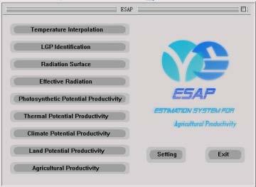
28 Patent certification and software developed Computable General Equilibrium on Land Use Change (CGELUC) model Dynamics of Land System(DLS) model System Dynamics of Land Use Changes(SDLUC) model Areal Sampling Toolset (AST) Software estimation system for agricultural productivity(esap) model Spatial extrapolation Toolset (SET) software

29 Policy briefs and awards Applications endorsed more than ten times, Research awarded by prizes twice

30 Applications for decision makings at all levels
31 Outline of this talk Background Framework An application Development prospect
 referring to the Platform Natural resources pattern Economic pattern Tourism industrial pattern Ecological civilization mode Regional economic integration mode Transportation")
32 Promising applications for environmental protection and sustainable development for nations/regions Data Integration Identification of the Interactions between REE (Resource, Ecology and Environment) &D (Development) referring to the Platform Natural resources pattern Economic pattern Tourism industrial pattern Ecological civilization mode Regional economic integration mode Transportation economic belt mode Development mode of international tourism economic zone Technology cultural cooperation

33 Promising applications for environmental protection and sustainable development for nations/regions Estimation of parameters The evolution and driving forces of landscape of nations/regions The spatial patterns and the interactive mechanism of agriculture and nature resource management of nations/regions Investigating and handling the conflictions between development and conservation referring to the Platform

34 Promising applications for the environmental protection and sustainable development for nations/regions Scenario designs Status of economic integration Strategic directions for the formation of ecology-oriented investment policy on the territories with environmental Strategy of the balanced regional development in conditions of natural limitations International cooperation for scientific data sharing in the Trans-boundary basin of lake Baikal Scenarios designs considering the enablers as well as constrain for both natural conservation and regional development

35 Promising applications for the environmental protection and sustainable development for nations/regions Decision-making Support System Assessment of resource and environment carrying capacity and ecological service functions of nations/regions around the sustainable development of agriculture. Strategy of the balanced regional development in conditions of natural limitations Software toolset specifically developed for tracing the COOKED or VALVED pressures with enhanced development referring to the Platform

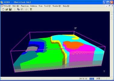
36 Demonstrations of the spatially explicit outcomes Baseline scenario Fragile area restrict development scenario Regional differentiated development scenario

37 Validation and Calibrations Predicted value value Open Other Cultivated Unused Built-up Brush Water Forest Grassland forest woodland body area Judgment Judgment accuracy accuracy Observed value land Cultivated Open Grassland Built-up Unused Forest Water Other Brush forest woodland body area Total Cultivated land Built-up area Open forest land Grassland Unused land Brush wood Water body Forest land Other woodland
38 Concluding remarks This kind of Platform is capable of offering spatial explicitly decision support information for achieving the Win-Win objectives of both agriculture and natural resource management. There is an urgent need to integrate geophysical process into the socio-economic development, or vice versa, in this kind of Platform which facilitates the so called Science Informs Policy; Prioritized research themes on the agricultural and natural resource management would be enhanced by developing and using this kind of Platform via, last but the least, the data integration, estimation of parameters, scenario designs, DSS developments referring to this kind of Platform

39 The most urgent research topics? Data, definition and classification Specific training on data aggregation and/or disaggregation over space and/or over time Capacity building on integrated modelling
40 9 th APGEOSS Symposium Thanks for your attention! Xiangzheng Deng
CLIMATE RESILIENT ALTITUDINAL GRADIENTS (CRAGs)
") CLIMATE RESILIENT ALTITUDINAL GRADIENTS (CRAGs) BUILDING CLIMATE CHANGE RESILIENCE IN THE KIVU- RUSIZI WATERSHEDS Great Lake Conference Entebbe 2017 Chris Magero WHAT ARE CRAGs? Climate-Resilient Altitudinal
CLIMATE RESILIENT ALTITUDINAL GRADIENTS (CRAGs) BUILDING CLIMATE CHANGE RESILIENCE IN THE KIVU- RUSIZI WATERSHEDS Great Lake Conference Entebbe 2017 Chris Magero WHAT ARE CRAGs? Climate-Resilient Altitudinal
DEM-based Ecological Rainfall-Runoff Modelling in. Mountainous Area of Hong Kong
 DEM-based Ecological Rainfall-Runoff Modelling in Mountainous Area of Hong Kong Qiming Zhou 1,2, Junyi Huang 1* 1 Department of Geography and Centre for Geo-computation Studies, Hong Kong Baptist University,
Mapping and Assessment of Ecosystems and their Services
 Mapping and Assessment of Ecosystems and their Services ALTER-Net Conference 2013: Science underpinning the EU 2020 Biodiversity Strategy. April 2013 Gent Joachim MAES 1 This presentation is based on the
Progress on GCOS-China CMA IOS Development Plan ( ) PEI, Chong Department of Integrated Observation of CMA 09/25/2017 Hangzhou, China
 PEI, Chong Department of Integrated Observation of CMA 09/25/2017 Hangzhou, China") Progress on GCOS-China CMA IOS Development Plan (2016-2020) PEI, Chong Department of Integrated Observation of CMA 09/25/2017 Hangzhou, China 1. Progress on GCOS-China 1 Organized GCOS-China GCOS-China
Progress on GCOS-China CMA IOS Development Plan (2016-2020) PEI, Chong Department of Integrated Observation of CMA 09/25/2017 Hangzhou, China 1. Progress on GCOS-China 1 Organized GCOS-China GCOS-China
THE 3D SIMULATION INFORMATION SYSTEM FOR ASSESSING THE FLOODING LOST IN KEELUNG RIVER BASIN
 THE 3D SIMULATION INFORMATION SYSTEM FOR ASSESSING THE FLOODING LOST IN KEELUNG RIVER BASIN Kuo-Chung Wen *, Tsung-Hsing Huang ** * Associate Professor, Chinese Culture University, Taipei **Master, Chinese
Landslide Hazard Assessment Methodologies in Romania
 A Scientific Network for Earthquake, Landslide and Flood Hazard Prevention SciNet NatHazPrev Landslide Hazard Assessment Methodologies in Romania In the literature the terms of susceptibility and landslide
National Adaptation Geo-information System (NAGiS) project in Hungary
 project in Hungary") National Adaptation Geo-information System (NAGiS) project in Hungary Mr. Péter Kajner Hungarian Mining and Geological Survey (MBFSZ) National Adaptation Center Department CGE webinar: Geo-information
National Adaptation Geo-information System (NAGiS) project in Hungary Mr. Péter Kajner Hungarian Mining and Geological Survey (MBFSZ) National Adaptation Center Department CGE webinar: Geo-information
Emerging Needs, Challenges and Response Strategy
 Emerging Needs, Challenges and Response Strategy Development of Integrated Observing Systems in China JIAO Meiyan Deputy Administrator China Meteorological Administration September 2011 Geneva Outline
The known requirements for Arctic climate services
 The known requirements for Arctic climate services based on findings described in STT White paper 8/2015 Johanna Ekman / EC PHORS STT Regional drivers The Arctic region is home to almost four million people
GGY 301: Research Methods
 GGY 301: Research Methods Course No GGY 301 Course Title Research Methods Core/Optional Core for Special Degree :This course provides students with a basic knowledge and understanding of the research methodology
Jordan's Strategic Research Agenda in cultural heritage
 Jordan's Strategic Research Agenda in cultural heritage Analysis of main results Alessandra Gandini Amman, Jordan 3 rd November 2013 Main objectives The work performed had the main objective of giving
Land Use in the context of sustainable, smart and inclusive growth
 Land Use in the context of sustainable, smart and inclusive growth François Salgé Ministry of sustainable development France facilitator EUROGI vice president AFIGéO board member 1 Introduction e-content+
I CAN DO sheets Southchurch High School
 Rate your confidence in the following topic content and geographical skills by ticking the appropriate column beside each point: Red = Not confident Yellow = Almost there Green = Confident Changing landscapes
Government GIS and its Application for Decision Support
 Government GIS and its Application for Decision Support Zhang Qingpu (Chinese Academy of Surveying and Mapping, Email: zhangqp@casm.ac.cn) Abstract: Application of GIS in government agencies is called
Country Report Nepal Geospatial Data Sharing Initiatives of Survey Department Supporting Disaster Management
 Third JPTM Step 2 for Sentinel Asia 6-8 July, 2010 Manila, The Philippines Country Report Nepal Geospatial Data Sharing Initiatives of Survey Department Supporting Disaster Management Durgendra M Kayastha
This table connects the content provided by Education Perfect to the NSW Syllabus.
 Education Perfect Geography provides teachers with a wide range of quality, engaging and innovative content to drive positive student learning outcomes. Designed by teachers and written by our in-house
Indicators of sustainable development: framework and methodologies CSD Indicators of sustainable development 1996
 Indicators of sustainable development: framework and methodologies CSD Indicators of sustainable development 1996 Keywords: mountain areas, mountain development, natural resources management, sustainable
Liana Talaue McManus. Division of Marine Affairs and Policy Rosenstiel School of Marine & Atmospheric Science University of Miami
 Liana Talaue McManus Division of Marine Affairs and Policy Rosenstiel School of Marine & Atmospheric Science University of Miami Outline 1. Coasts as vulnerable & resilient social ecological systems 2.
Flash Flood Guidance System On-going Enhancements
 Flash Flood Guidance System On-going Enhancements Hydrologic Research Center, USA Technical Developer SAOFFG Steering Committee Meeting 1 10-12 July 2017 Jakarta, INDONESIA Theresa M. Modrick Hansen, PhD
Graduate Courses Meteorology / Atmospheric Science UNC Charlotte
 Graduate Courses Meteorology / Atmospheric Science UNC Charlotte In order to inform prospective M.S. Earth Science students as to what graduate-level courses are offered across the broad disciplines of
Plan4all (econtentplus project)
") Plan4all (econtentplus project) Karel CHARVAT 1, Tomáš MILDORF 2 1 Help service remote sensing, Ltd., Černoleská 1600, 256 01 Benešov u Prahy, Czech Republic charvat@bnhelp.cz 2 Department of Mathematics
Plan4all (econtentplus project) Karel CHARVAT 1, Tomáš MILDORF 2 1 Help service remote sensing, Ltd., Černoleská 1600, 256 01 Benešov u Prahy, Czech Republic charvat@bnhelp.cz 2 Department of Mathematics
ROLE OF SPATIAL PLANNING TOOLS AT MESO-SCALE IN THE MANAGEMENT OF NATURAL RESOURCES, LESSONS LEARNT FROM AFRICAN COUNTRIES
 6th Nov, 2012 ROLE OF SPATIAL PLANNING TOOLS AT MESO-SCALE IN THE MANAGEMENT OF NATURAL RESOURCES, LESSONS LEARNT FROM AFRICAN COUNTRIES Masoom Hamdard Environmental Planning and Assessment for Adaptation
National Remote Sensing Center of China. Space Technology for Sustainable Development in China Status, Achievements and Futures.
 National Remote Sensing Center of China Space Technology for Sustainable Development in China Status, Achievements and Futures Jing Li National Remote Sensing Center of China Ministry of Science and Technology,
Geography General Course Year 12. Selected Unit 3 syllabus content for the. Externally set task 2019
 Geography General Course Year 12 Selected Unit 3 syllabus content for the Externally set task 2019 This document is an extract from the Geography General Course Year 12 syllabus, featuring all of the content
A Web-GIS Based Integrated Climate Adaptation Model (ICAM): Exemplification from the City of Melbourne, Australia
: Exemplification from the City of Melbourne, Australia") A Web-GIS Based Integrated Climate Adaptation Model (ICAM): Exemplification from the City of Melbourne, Australia JOSHPHAR KUNAPO 1,2, MATTHEW J. BURNS 1, TIM D. FLETCHER 1, ANTHONY R. LADSON 3, LUKE CUNNINGHAM
A Web-GIS Based Integrated Climate Adaptation Model (ICAM): Exemplification from the City of Melbourne, Australia JOSHPHAR KUNAPO 1,2, MATTHEW J. BURNS 1, TIM D. FLETCHER 1, ANTHONY R. LADSON 3, LUKE CUNNINGHAM
Preliminary assessment of socio-economic benefits from CMA Meteorological Satellite Programmes. Dr. ZHENG Guoguang / YANG Jun
 Preliminary assessment of socio-economic benefits from CMA Meteorological Satellite Programmes Dr. ZHENG Guoguang / YANG Jun China Meteorological Administration CMA report to CM-12 WMO HQ, June 21, 2014
OCR 2008 AS and A level Geography Specification Mapping Guide
 OCR 2008 AS and A level Geography Specification Mapping Guide Contents Introduction Error! Bookmark not defined. Specification map: 2008 OCR AS and A level Geography 3 What's new? 10 Introduction This
Surface Connects Author Index
 Surface Connects Author Index Shixin WANG, Yi ZHOU, Gewei LI, Weiqi ZHOU, Yalan LIU & Shirong CHEN NETWORK PLATFORM OF REMOTE SENSING FOR NATURAL DISASTER MONITORING & INFORMATION SERVING AND ITS APPLICATIONS
Estimation of landslides activities evolution due to land use changes in a Pyrenean valley
 Estimation of landslides activities evolution due to land use changes in a Pyrenean valley R. Vandromme, N. Desramaut, S. Bernardie, G. Grandjean 1 Introduction (1) > Need to produce dynamic susceptibility
Transactions on Information and Communications Technologies vol 18, 1998 WIT Press, ISSN
 STREAM, spatial tools for river basins, environment and analysis of management options Menno Schepel Resource Analysis, Zuiderstraat 110, 2611 SJDelft, the Netherlands; e-mail: menno.schepel@resource.nl
Physical Geography: Patterns, Processes, and Interactions, Grade 11, University/College Expectations
 Geographic Foundations: Space and Systems SSV.01 explain major theories of the origin and internal structure of the earth; Page 1 SSV.02 demonstrate an understanding of the principal features of the earth
WORLD DAY TO COMBAT DESERTIFICATION 2018 IN MONGOLIA
 WORLD DAY TO COMBAT DESERTIFICATION 2018 IN MONGOLIA This year the WDCD slogan was Land has true value. Invest in it to address the importance of sustainable land use, land degradation prevention and its
Chitra Sood, R.M. Bhagat and Vaibhav Kalia Centre for Geo-informatics Research and Training, CSK HPKV, Palampur , HP, India
 APPLICATION OF SPACE TECHNOLOGY AND GIS FOR INVENTORYING, MONITORING & CONSERVATION OF MOUNTAIN BIODIVERSITY WITH SPECIAL REFERENCE TO MEDICINAL PLANTS Chitra Sood, R.M. Bhagat and Vaibhav Kalia Centre
Dataset of Classification and Land Use of the Ecological Core Areas of China
 Journal of Global Change Data & Discovery. 2017, 1(4):426-430 DOI:10.3974/geodp.2017.04.07 www.geodoi.ac.cn 2017 GCdataPR Global Change Research Data Publishing & Repository Dataset of Classification and
Assessment and valuation of Ecosystem Services for decision-makers
 Assessment and valuation of Ecosystem Services for decision-makers An introduction to the ARIES approach Ferdinando Villa *, Ken Bagstad Gary Johnson, Marta Ceroni *Basque Center for Climate Change, Bilbao,
World Meteorological Organization
 World Meteorological Organization Opportunities and Challenges for Development of Weather-based Insurance and Derivatives Markets in Developing Countries By Maryam Golnaraghi, Ph.D. Head of WMO Disaster
Contents Research Objects, Tasks and Historical Development of Tourism Earth-science Role of Tourism Earth-science in Tourism Development
 Contents 1 Research Objects, Tasks and Historical Development of Tourism Earth-science.... 1 1.1 Research Objects of Tourism Earth-science.... 1 1.1.1 Definition of Tourism Earth-science... 1 1.1.2 Definition
ACTION PLAN FOR WORLD HERITAGE IN LATIN AMERICA AND THE CARIBBEAN ( )
") Annex ACTION PLAN FOR WORLD HERITAGE IN LATIN AMERICA AND THE CARIBBEAN (2014-2024) The current Regional Action Plan for Latin America and the Caribbean for 2014-2024 has been elaborated by the State Parties
Annex ACTION PLAN FOR WORLD HERITAGE IN LATIN AMERICA AND THE CARIBBEAN (2014-2024) The current Regional Action Plan for Latin America and the Caribbean for 2014-2024 has been elaborated by the State Parties
ENVS S102 Earth and Environment (Cross-listed as GEOG 102) ENVS S110 Introduction to ArcGIS (Cross-listed as GEOG 110)
 ENVS S110 Introduction to ArcGIS (Cross-listed as GEOG 110)") ENVS S102 Earth and Environment (Cross-listed as GEOG 102) 1. Describe the fundamental workings of the atmospheric, hydrospheric, lithospheric, and oceanic systems of Earth 2. Explain the interactions
ENVS S102 Earth and Environment (Cross-listed as GEOG 102) 1. Describe the fundamental workings of the atmospheric, hydrospheric, lithospheric, and oceanic systems of Earth 2. Explain the interactions
Land Accounts - The Canadian Experience
 Land Accounts - The Canadian Experience Development of a Geospatial database to measure the effect of human activity on the environment Who is doing Land Accounts Statistics Canada (national) Component
DEPARTMENT OF GEOGRAPHY B.A. PROGRAMME COURSE DESCRIPTION
 DEPARTMENT OF GEOGRAPHY B.A. PROGRAMME COURSE DESCRIPTION (3 Cr. Hrs) (2340100) Geography of Jordan (University Requirement) This Course pursues the following objectives: - The study the physical geographical
KUNMING FORUM ON UNITED NATIONS GLOBAL GEOSPATIAL INFORMATION MANAGEMENT CITIES OF THE FUTURE: SMART, RESILIENT
 KUNMING FORUM ON UNITED NATIONS GLOBAL GEOSPATIAL INFORMATION MANAGEMENT CITIES OF THE FUTURE: SMART, RESILIENT and SUSTAINABLE Yunnan Zhenzhuang Guest House, Kunming, China 10 12 May 2017 BACKGROUND CONCEPT
Minnesota K-12 Academic Standards in Social Studies. Grade 4: Geography of North America
 Minnesota K-12 Academic s in Social Studies Grade 4: Geography of North America 4 Describe how people take 1. Democratic government action to influence a depends on informed and decision on a specific
Application of Remote Sensing Techniques for Change Detection in Land Use/ Land Cover of Ratnagiri District, Maharashtra
 IOSR Journal of Applied Geology and Geophysics (IOSR-JAGG) e-issn: 2321 0990, p-issn: 2321 0982.Volume 3, Issue 6 Ver. II (Nov. - Dec. 2015), PP 55-60 www.iosrjournals.org Application of Remote Sensing
GIS as a tool in flood management
 GIS for the United Nations and the International Community Conference Panel: GIS and Capacity - How Territorial Planning Benefits from Geospatial Information 3-5 April 2012 Geneva, Switzerland GIS as a
3/29/11. Why bother with tools? Incorporating Decision Support Tools into Climate Adaptation Planning. A Simplified Planning Process
 Incorporating Decision Support Tools into Climate Adaptation Planning Why bother with tools? Tools don t eliminate complexity but they can help deal with it" Tools can:"! Help incorporate science into
Green Space Services for Local Monitoring
 Green Space Services for Local Monitoring Aratos Group V3.0 2016/08 Value added services for the society using space and satellite technologies Aratos Group 2 One of the first European downstream value
Watershed Classification with GIS as an Instrument of Conflict Management in Tropical Highlands of the Lower Mekong Basin
 Page 1 of 8 Watershed Classification with GIS as an Instrument of Conflict Management in Tropical Highlands of the Lower Mekong Basin Project Abstract The University of Giessen is actually planning a research
Earth Observation and GEOSS in Horizon Copernicus for Raw Material Workshop 5 th September 2016
 Earth Observation and GEOSS in Horizon 2020 Copernicus for Raw Material Workshop 5 th September 2016 Gilles OLLIER Head of Sector -Earth observation Directorate Environment Unit I.4 Climate Actions and
Building the Sustainable Network of Settlements on the Caspian Sea Region of Kazakhstan
 Building the Sustainable Network of Settlements on the Caspian Sea Region of Kazakhstan Introduction The Ecological Zoning and Identification of Ecological Capacity of Natural and Socio- Economic Potential
GENERAL. CHAPTER 1 BACKGROUND AND PURPOSE OF THE GUIDELINES Background of the Guidelines Purpose of the Guidelines...
 GENERAL CHAPTER 1 BACKGROUND AND PURPOSE OF THE GUIDELINES... 1 1.1 Background of the Guidelines... 1 1.2 Purpose of the Guidelines... 3 CHAPTER 2 APPLICATION OF THE GUIDELINES... 3 2.1 Potential Users
WMO Priorities and Perspectives on IPWG
 WMO Priorities and Perspectives on IPWG Stephan Bojinski WMO Space Programme IPWG-6, São José dos Campos, Brazil, 15-19 October 2012 1. Introduction to WMO Extended Abstract The World Meteorological Organization
GEOGRAPHY. In relation to the above aims, candidates should, after completing this syllabus, be able to
 GEOGRAPHY AIMS The aims of this syllabus are to enable candidates 1. to recognize and understand the arrangement of phenomena and features on Earth as well as the inter-relationship and interaction among
Pacemaker World Geography and Cultures. correlated to. Louisiana Social Studies Grade Level Expectations: World Geography Geography Grades 9-12
 Pacemaker World and Cultures correlated to Louisiana Social Studies Grade Level Expectations: World Grades 9-12 Pacemaker World and Cultures Pearson Learning Group correlated to Louisiana Social Studies
TOWARDS CLIMATE-RESILIENT COASTAL MANAGEMENT: OPPORTUNITIES FOR IMPROVED ICZM IN BELIZE
 TOWARDS CLIMATE-RESILIENT COASTAL MANAGEMENT: OPPORTUNITIES FOR IMPROVED ICZM IN BELIZE CHANTALLE SAMUELS Coastal Zone Management Authority and Institute The Caribbean Community Climate Change Centre VULNERABILITY
An internet based tool for land productivity evaluation in plot-level scale: the D-e-Meter system
 An internet based tool for land productivity evaluation in plot-level scale: the D-e-Meter system Tamas Hermann 1, Ferenc Speiser 1 and Gergely Toth 2 1 University of Pannonia, Hungary, tamas.hermann@gmail.com
Semester: Two. Study Hours: 28 contact/80 independent BSU Credits: 10 ECTS: 5
 BATH SPA UNIVERSITY Erasmus, exchange & study abroad module catalogue Geography: semester 2 Modules at Bath Spa University are usually worth either 10, 20 or 40 credits. If you are using the European Credit
GIS in Weather and Society
 GIS in Weather and Society Olga Wilhelmi Institute for the Study of Society and Environment National Center for Atmospheric Research WAS*IS November 8, 2005 Boulder, Colorado Presentation Outline GIS basic
Challenges and Issues for Regional Geoportal on Disaster Data Sharing - from Perspective of China
 The 3 rd UN-GGIM-AP Plenary Meeting Challenges and Issues for Regional Geoportal on Disaster Data Sharing - from Perspective of China ZHOU Xu, Vice Chair of WG2 National Geomatics Center of China Outline
International Symposium on Natural Disaster Mitigation. Local vulnerability assessment of landslides and debris flows
 International Symposium on Natural Disaster Mitigation of landslides and debris flows Lessons learnt from Cam Pha town and Van Don district, Quang Ninh province, Vietnam Nguyen Quoc Phi Faculty of Environment
TOWARDS STRATEGIC SPATIAL PLANNING IN JAMAICA: THE NATIONAL SPATIAL PLAN
 TOWARDS STRATEGIC SPATIAL PLANNING IN JAMAICA: THE NATIONAL SPATIAL PLAN JIEP 5th Biennial Conference on the Environment: Balancing National Development and Environmental Protection June 6, 2011 Jamaica
Foundation Geospatial Information to serve National and Global Priorities
 Foundation Geospatial Information to serve National and Global Priorities Greg Scott Inter-Regional Advisor Global Geospatial Information Management United Nations Statistics Division UN-GGIM: A global
Hydrologic Modelling of the Upper Malaprabha Catchment using ArcView SWAT
 Hydrologic Modelling of the Upper Malaprabha Catchment using ArcView SWAT Technical briefs are short summaries of the models used in the project aimed at nontechnical readers. The aim of the PES India
EO Information Services. Assessing Vulnerability in the metropolitan area of Rio de Janeiro (Floods & Landslides) Project
 Project") EO Information Services in support of Assessing Vulnerability in the metropolitan area of Rio de Janeiro (Floods & Landslides) Project Ricardo Armas, Critical Software SA Haris Kontoes, ISARS NOA World
EO Information Services in support of Assessing Vulnerability in the metropolitan area of Rio de Janeiro (Floods & Landslides) Project Ricardo Armas, Critical Software SA Haris Kontoes, ISARS NOA World
Spatial Analysis and Modeling of Urban Land Use Changes in Lusaka, Zambia: A Case Study of a Rapidly Urbanizing Sub- Saharan African City
 Spatial Analysis and Modeling of Urban Land Use Changes in Lusaka, Zambia: A Case Study of a Rapidly Urbanizing Sub- Saharan African City January 2018 Matamyo SIMWANDA Spatial Analysis and Modeling of
EXPERT ANALYSIS ON GEOGRAPHICAL SPECIFICITIES
 EXPERT ANALYSIS ON GEOGRAPHICAL SPECIFICITIES Mountains, Islands and Sparsely Populated Areas Dr. Gilda Carbone 9 Oct 2018 Objectives: to gather basic information from relevant programming documents (PAs,
USING GIS AND AHP TECHNIQUE FOR LAND-USE SUITABILITY ANALYSIS
 USING GIS AND AHP TECHNIQUE FOR LAND-USE SUITABILITY ANALYSIS Tran Trong Duc Department of Geomatics Polytechnic University of Hochiminh city, Vietnam E-mail: ttduc@hcmut.edu.vn ABSTRACT Nowadays, analysis
4.17 Spain. Catalonia
 4.17 Spain Catalonia In Spain, inundation studies are the responsibility of the respective Hydrographic Confederations of each river basin (River Basin Authorities). The actual status of inundation studies
Wisconsin Academic Standards Science Grade: 5 - Adopted: 1998
 Main Criteria: Wisconsin Academic Standards Secondary Criteria: Subjects: Science, Social Studies Grade: 5 Correlation Options: Show Correlated Wisconsin Academic Standards Science Grade: 5 - Adopted:
Application of remote sensing for agricultural disasters
 Application of remote sensing for agricultural disasters Bingfang Wu, Sheng Chang Institute of Remote Sensing and Digital Earth (RADI) Chinese Academy of Sciences (CAS) wubf@radi.ac.cn, changsheng@radi.ac.cn
Using Geographic Information Systems and Remote Sensing Technology to Analyze Land Use Change in Harbin, China from 2005 to 2015
 Using Geographic Information Systems and Remote Sensing Technology to Analyze Land Use Change in Harbin, China from 2005 to 2015 Yi Zhu Department of Resource Analysis, Saint Mary s University of Minnesota,
Use of climate reanalysis for EEA climate change assessment. Blaz Kurnik. European Environment Agency (EEA)
") Use of climate reanalysis for EEA climate change assessment Blaz Kurnik European Environment Agency (EEA) 2016: EEA content priorities Circular economy Climate and Energy Sustainable Development Goals
Use of climate reanalysis for EEA climate change assessment Blaz Kurnik European Environment Agency (EEA) 2016: EEA content priorities Circular economy Climate and Energy Sustainable Development Goals
USING GIS CARTOGRAPHIC MODELING TO ANALYSIS SPATIAL DISTRIBUTION OF LANDSLIDE SENSITIVE AREAS IN YANGMINGSHAN NATIONAL PARK, TAIWAN
 CO-145 USING GIS CARTOGRAPHIC MODELING TO ANALYSIS SPATIAL DISTRIBUTION OF LANDSLIDE SENSITIVE AREAS IN YANGMINGSHAN NATIONAL PARK, TAIWAN DING Y.C. Chinese Culture University., TAIPEI, TAIWAN, PROVINCE
Geography Class XI Fundamentals of Physical Geography Section A Total Periods : 140 Total Marks : 70. Periods Topic Subject Matter Geographical Skills
 Geography Class XI Fundamentals of Physical Geography Section A Total Periods : 140 Total Marks : 70 Sr. No. 01 Periods Topic Subject Matter Geographical Skills Nature and Scope Definition, nature, i)
Advancing Geoscientific Capability. Geological Survey of Finland
 Advancing Geoscientific Capability Geological Survey of Finland GTK in brief The Geological Survey of Finland (GTK) is one of the largest European centres of excellence in assessment, research and the
The Safeland Project General Overview and Monitoring Technology Development
 Ber. Geol. B. A., 82, ISSN 1017 8880 Landslide Monitoring Technologies & Early Warning Systems The Safeland Project General Overview and Monitoring Technology Development The SafeLand Consortium a), N.
The Spatial Information Corridor Contributes to UNISPACE+50. JIANG HUI Director of Internation Cooperation Department
 The Spatial Information Corridor Contributes to UNISPACE+50 JIANG HUI Director of Internation Cooperation Department 01 02 03 What is Belt & Road Spatial Information Corridor? China put forward the "Belt
Geographic Information Infrastructure and Policy Framework for Sustainable Mountain Development in the Hindu Kush-Himalayas
 Geo SMART ASIA 2017 22-24 August, Kualalampur Geographic Information Infrastructure and Policy Framework for Sustainable Mountain Development in the Hindu Kush-Himalayas Basanta Shrestha, Director Strategic
To Construct the Theory and Practice System of Integrated Disaster Risk Management
 WCDR, 18-22 January 2005, Kobe, Japan To Construct the Theory and Practice System of Integrated Disaster Risk Management Peijun Shi 1, Norio Okada 2 1.IDPS, Beijing Normal University, China 2. DPRI, Kyoto
1 INTRODUCTION. 1.1 Context
 1 INTRODUCTION 1.1 Context During the last 30 years ski run construction has been one of the major human activities affecting the Alpine environment. The impact of skiing on environmental factors and processes,
Geospatial technology for land cover analysis
 Home Articles Application Environment & Climate Conservation & monitoring Published in : Middle East & Africa Geospatial Digest November 2013 Lemenkova Polina Charles University in Prague, Faculty of Science,
Space Application in Support of Land Management for SDG Implementation
 Space Application in Support of Land Management for SDG Implementation Regional Expert Workshop on Land Accounting for SDG Monitoring and Reporting 26 September 2017 Space Application Section Information
New Frameworks for Urban Sustainability Assessments: Linking Complexity, Information and Policy
 New Frameworks for Urban Sustainability Assessments: Linking Complexity, Information and Policy Moira L. Zellner 1, Thomas L. Theis 2 1 University of Illinois at Chicago, Urban Planning and Policy Program
GEOMATICS. Shaping our world. A company of
 GEOMATICS Shaping our world A company of OUR EXPERTISE Geomatics Geomatics plays a mayor role in hydropower, land and water resources, urban development, transport & mobility, renewable energy, and infrastructure
GEOGRAPHY (GE) Courses of Instruction
 Courses of Instruction") GEOGRAPHY (GE) GE 102. (3) World Regional Geography. The geographic method of inquiry is used to examine, describe, explain, and analyze the human and physical environments of the major regions of the
GEOGRAPHY (GE) GE 102. (3) World Regional Geography. The geographic method of inquiry is used to examine, describe, explain, and analyze the human and physical environments of the major regions of the
GTZ Partner for the Future. Worldwide.
 GTZ Partner for the Future. Worldwide. Multidisciplinary approach of information system for integrated water resources management and biodiversity data gathering: an example for benefits from cross-linking
Mapping Water Resources and Reservoirs for Climate Resilience in Zambezi River Basin
 Mapping Water Resources and Reservoirs for Climate Resilience in Zambezi River Basin Corné van der Sande, NEO BV Senior Advisor Earth Observation Services for Monitoring Drought and Water Resources in
Providers of Weather, Climate and Water Information
 Providers of Weather, Climate and Water Information Mnikeli Ndabambi World Meteorological Organization Task Force on Social and Economic Applications of Public Weather Services Geneva, 15-18 May 2006 Introductory
Abdolreza Ansari Amoli. Remote Sensing Department Iranian Space Agency
 Risk Assessment and Mapping Using Earth Observation Data In Iran Abdolreza Ansari Amoli Remote Sensing & GIS Expert Remote Sensing Department Iranian Space Agency Different Types of Disasters in Iran Epidemic
Geography. Geography A. Curriculum Planner and Skills Mapping Grid GCSE Version 1 October 2012
 Geography GCSE 2012 Geography A Curriculum Planner and Skills Mapping Grid Version 1 October 2012 www.ocr.org.uk/gcse2012 Year 10 Exam work Controlled Assessment Autumn 1 Autumn 2 Spring 1 Spring 2 Summer
Role of GIS and Remote Sensing to Environment Statistics
 United Nations Economic Commission for Africa Role of GIS and Remote Sensing to Environment Dozie Ezigbalike Data Management Coordinator A Definition Environment statistics are statistics that describe
8 Current Issues and Research on Sediment Movement in the River Catchments of Japan
 8 Current Issues and Research on Sediment Movement in the River Catchments of Japan YUTAKA ICHIKAWA INTRODUCTION Prediction of sediment movement is one of the challenging tasks in water-related research.
Economic Benefit Study on Value of Spatial Information Australian Experience
 Economic Benefit Study on Value of Spatial Information Australian Experience Dr Zaffar Sadiq Mohamed-Ghouse Director, International Relations Cooperative Research Centre for Spatial Information zsadiq@crcsi.com.au
GenEd Courses offered by Dept. of Geography, Presidency University
 GenEd Courses offered by Dept. of Geography, Presidency University (All the Courses are offered to both Science and Humanities Students) Semester Course No. Course Name Maximum No. of Students (originally
AQA A level Geography (2016) Mapping Guide
 Mapping Guide") AQA A level Geography (2016) Mapping Guide At a glance comparison of the AQA and Edexcel specifications...page 2 Support for teaching Edexcel AS and A level Geography...Page 3 What is the same?...page
AQA A level Geography (2016) Mapping Guide At a glance comparison of the AQA and Edexcel specifications...page 2 Support for teaching Edexcel AS and A level Geography...Page 3 What is the same?...page
Project Name: Implementation of Drought Early-Warning System over IRAN (DESIR)
") Project Name: Implementation of Drought Early-Warning System over IRAN (DESIR) IRIMO's Committee of GFCS, National Climate Center, Mashad November 2013 1 Contents Summary 3 List of abbreviations 5 Introduction
Project Name: Implementation of Drought Early-Warning System over IRAN (DESIR) IRIMO's Committee of GFCS, National Climate Center, Mashad November 2013 1 Contents Summary 3 List of abbreviations 5 Introduction
CEMAT results - over the years
 CEMAT results - over the years Technical Conference on Functional Areas capitalization of local potential within the territorial development policies in Europe European Conference of Ministers responsible
Mutah university faculty of Social Sciences The Study plan of the department of Geography 2006/2007
 Mutah university faculty of Social Sciences The Study plan of the department of Geography 2006/2007 Requirements university compulsory 22 Credit hours Course No Credit hours Prerequisite Requirements Faculty
Set-up of subnational statistical systems Statistical Development Strategy for the State of Jalisco México, 2016
 Set-up of subnational statistical systems Statistical Development Strategy for the State of Jalisco México, 2016 Statistical and Geographical Information Institute of Jalisco (IIEG) 2013. Merger of three
Fig 1. Steps in the EcoValue Project
 Assessing the Social and Economic Value of Ecosystem Services in the Northern Forest Region: A Geographic Information System (GIS) Approach to Landscape Valuation Principal Investigator(s): Dr. Matthew