Minnesota River Turbidity Stakeholder Committee New Ulm Library, August 27, 20090
|
|
|
- Teresa Kennedy
- 5 years ago
- Views:
Transcription

1 Identifying sediment sources in the Minnesota River Basin Peter Wilcock Dept of Geography & Environmental Engineering National Center for Earth Surface Dynamics Johns Hopkins University Minnesota River Turbidity Stakeholder Committee New Ulm Library, August 27, 20090
2 Context Sediment Sources Research Goals Methods for evaluating sediment sources Findings MN R Basin Subwatersheds Location within subwatersheds Local source & mechanism Sediment storage along the MN R

3 An Integrated Sediment Sediment Source Studies Budget in for the the Minnesota Le Sueur River Basin, Minnesota Lesley Perg Patrick Belmont Stephanie Day Assefa Melesse Luam Azmera Ashley Thomas Khalif Fukhrudin St. Croix Watershed Research Station Carrie Jennings Dan Engstrom Shawn Shottler Karen Gran Andrea Johnson Peter Wilcock Ben Hobbs, Sarah Jacobi, Pearl Zheng, Carol Zuerndorfer David Mulla John Nieber Wes Lauer Gary Parker Enrica Viparelli Minnesota River Basin Data Center Scott Matteson Pat Baskfield Chuck Regan
4
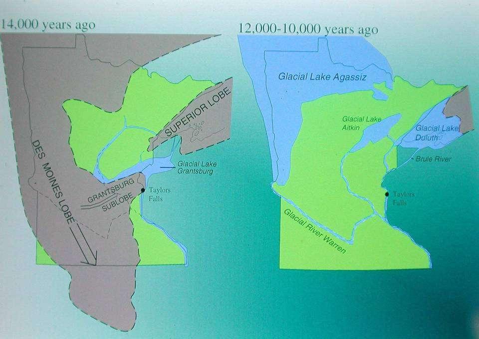
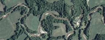
5 Illustration from Jim Miller, MGS

6 River Long Profiles Pre-11.5ka baselevel Post-11.5ka baselevel 11.5 ka: 70 m baselevel fall Rapid Holocene Incision in lower 40 km Holocene average knick migration rate = 3 m/yr vertical incision rate = 5 mm/yr
7 A grand geomorphic experiment
8
9


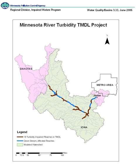
10 Minnesota River TMDL
11 Geologic control Land-use dominated response 10 3 Mg/yr Pre-settlement: 81% Mn R Present: 88% Mn R Engstrom & Allmendinger, 1997 Kelley & Nater, 2000
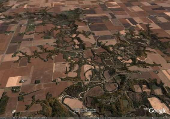
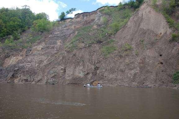
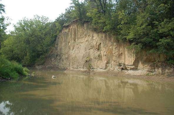
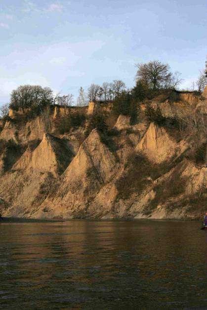
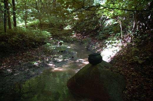
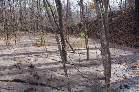
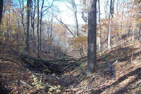
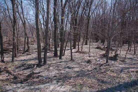
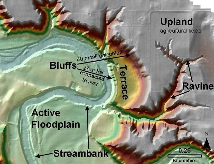
12 Sources Fields Ravines Bluffs Streambanks
13
14
15
16
17 Sources Fields Smaller erosion rates per area big area Ravines Bigger erosion rates per area small area Bluffs Bigger erosion rates per area small area Streambanks Must balance erosion, deposition
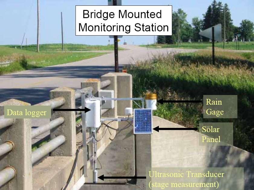
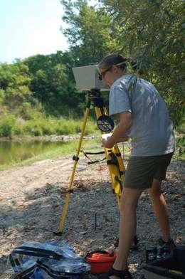
18 Methods Stream gaging Fingerprinting Source measurement & sediment budgeting
19

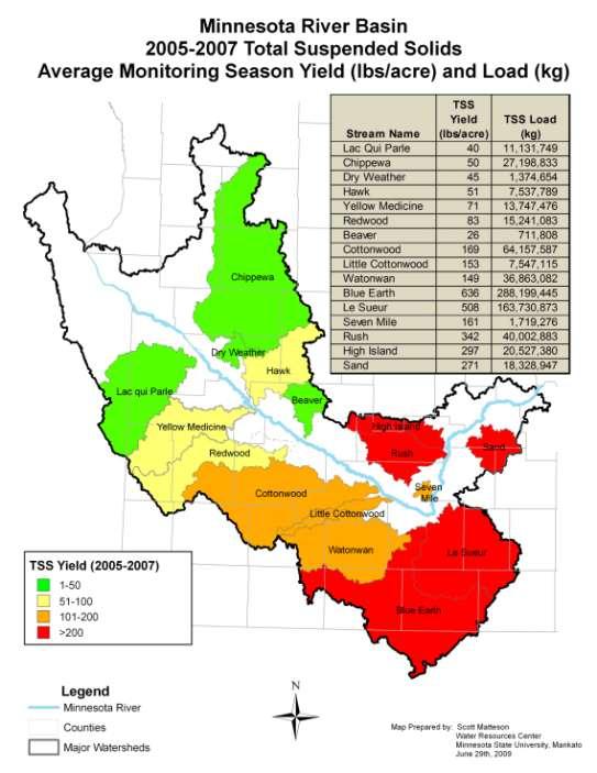
20 St. Croix Watershed Research Station Dan Engstrom, and Shawn Schottler. Dylan Bloomentritt


21
22
23 Sediment Budgets Adding it up provides context for evaluating magnitude of individual sources description of uncertainty
24 Findings Minnesota River Basin Subwatersheds Location with subwatersheds Erosion mechanism & local source Changes in Minnesota River sediment storage

25 Percent from Minnesota River Geochemical Analysis 10 3 Mg/yr Pre-settlement: 81% Mn R Present: 88% Mn R Engstrom & Allmendinger, 1997 Kelley & Nater, yr Mean 0 0 1,000,000 2,000,000 3,000,000 Annual Total Suspended Solids - Mg
26


27 TSS Yield (lbs/acre/yr) Upper Gage Lower Gage Cottonwood R Maple R Cobb R Le Sueur R Seven Mile Ck Rush R High Island Ck
28

29 If we are going to address the problem of eutrophication and turbidity in the receiving waters, we have to be specific about mechanism and location of sediment sources.

30 Le Sueur R Lower Maple Gage Blue Earth R Cobb R Maple R Upper Maple Gage
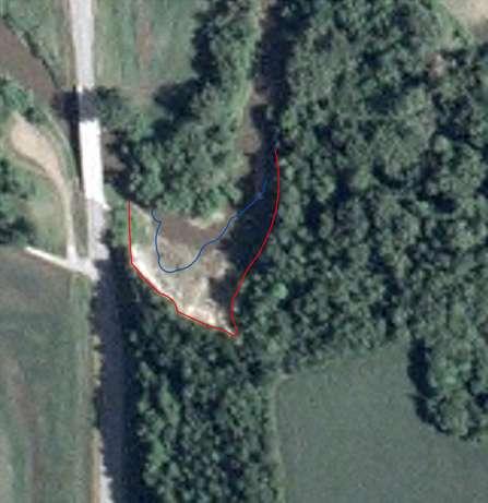
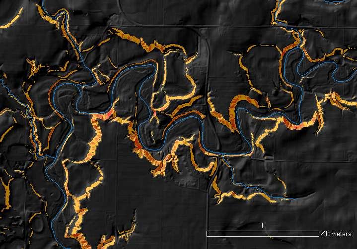
31 Unit Erosion Rate (Mg/m 2 /yr) Maple - Air Photo. Median = 0.045, N = 121 Le Sueur - Ground LiDAR. Median = 0.084, N = 8 Blue Earth - Ground Survey. Median = 0.078, N = 7 92% of Maple values are < 0.10 t/m 2 /yr 0 10,000 20,000 30,000 40,000 50,000 60,000 Bluff Surface Area (m 2 )
32 Lower Gage Between Gages 41,300 t/yr at Lower Gage Source Rate Unit Extent Unit Field 0 50 t/km 2 moderate km 2 Ravine t/m 2 small m 2 Bluff t/m 2 small m 2 Streambank t/m big m Upper Gage Above Upper Gage 7,800 t/yr at Upper Gage Source Rate Unit Extent Unit Field 0 50 t/km 2 big km 2 Ravine t/m 2 v little m 2 Bluff t/m 2 v little m 2 Streambank t/m small m
33 Can balance the budget with (i) relatively large sediment supply from fields, ravines, & bluffs but gives non-field percentage larger than shown by fingerprinting (ii) smaller sediment supply from fields, giving consistent fingerprinting percentages but extremely large supplies from ravines and bluffs Next steps: collect more gaging information evaluate fingerprinting at co-located samples evaluate potential for very high field yield near incised valleys evaluate potential for exceptionally large, rare, localized supplies from fields and ravines greater spatial detail from sediment routing model
34 Sediment routing model Tributaries Overland flow Erosion of bluffs and terraces Incision of ravines Overbank deposition Main floodplain Basal floodplain Channel Active layer Substrate collaboration with Gary Parker, Enrica Viparelli and Wes Lauer Newly deposited point bar Sediment exchanged between the layers as the channel migrates in the floodplain Sediment eroded from the floodplain for channel migration From Enrica Viparelli

35 Ft Snelling Jordan St Peter Judson
36 Annual TSS Balance (Mg) Input - Ft Snelling 750, % stored 50% stored 500,000 25% stored 250, , , ,000 1,000,000 1,250,000 1,500,000 1,750,000 2,000,000 Annual TSS Supply to Minnesota River Between Judson and Ft Snelling(Mg)
37 Ongoing and proposed work i. Stream gauging: TSS loads from principal tributaries and mainstem stations upstream/downstream paired gauges. ii. Complete sediment budget for the Le Sueur watershed. iii. Use sediment budgeting to reconcile erosion estimates from different methods. iv. Inventory of ravines and bluffs for incised portion of Minnesota River Basin. v. Develop basis for extrapolating sediment budgets from one watershed to another. vi. Develop a sediment budget for the Minnesota River mainstem. vii. Evaluate relative roles of changing climate, land use, & land management. vii. Evaluate tile and ditch drainage in changing stream flow and erosion potential. x. Link sediment budget models with decision analysis methods to prioritize management and monitoring actions
Patrick Baskfield. Scott Matteson. Minnesota Pollution Control Agency. Minnesota State University Water Resource Center
 Regression Analysis of Total Suspended Solids Concentrations to Estimate Streambank, Upland Field, and Classic Gully Sediment Contributions to Minnesota River Tributaries Patrick Baskfield Minnesota Pollution
low turbidity high turbidity
 What is Turbidity? Turbidity refers to how clear the water is. The greater the amount of total suspended solids (TSS) in the water, the murkier it appears and the higher the measured turbidity. Excessive
Modeling Upland and Channel Sources of Sediment in the Le Sueur River Watershed, Minnesota
 Modeling Upland and Channel Sources of Sediment in the Le Sueur River Watershed, Minnesota Solomon Folle and David Mulla Department of Soil, Water and Climate University of Minnesota August 6, 2009 5 th
Overview of fluvial and geotechnical processes for TMDL assessment
 Overview of fluvial and geotechnical processes for TMDL assessment Christian F Lenhart, Assistant Prof, MSU Research Assoc., U of M Biosystems Engineering Fluvial processes in a glaciated landscape Martin
Targeted water storage to maintain productive land and restore clean water
 Targeted water storage to maintain productive land and restore clean water Patrick Belmont Department of Watershed Sciences Utah State University Photo credit: Carrie Jennings None of our work would be
the path to studying tile drainage
 Fingerprinting Sources of Suspended Sediments Mean 210 Pb Flux (pci/cm 2 /yr) 2.5 2 1.5 1 0.5 Sagatagan Kreighle Henderson George Long Diamond Duck Stahl Reference Lakes y = 0.65 + 4.8x R 2 = 0.58 Hook
Geomorphic evolution of the Le Sueur River, Minnesota, USA, and implications for current sediment loading
 spe 451-08 1st pgs page 1 The Geological Society of America Special Paper 451 2009 Geomorphic evolution of the Le Sueur River, Minnesota, USA, and implications for current sediment loading Karen B. Gran
Assessing Differences in Ravine Erosion in Seven Mile Creek Park and the Surrounding Area: Implications for Sediment in the Minnesota River
 Assessing Differences in Ravine Erosion in Seven Mile Creek Park and the Surrounding Area: Implications for Sediment in the Minnesota River By Laura Danczyk A thesis submitted in partial fulfillment of
Stephanie S. Day NDSU Dept. 2745, PO Box 6050, Fargo, ND
 Stephanie S. Day NDSU Dept. 2745, PO Box 6050, Fargo, ND 58108 701-231-8837 stephanie.day@ndsu.edu Education: University of Minnesota August 2006 July 2012 Ph.D. in Geology Advisors: Karen Gran and Chris
CSSR: Collaborative for Sediment Source Reduction Greater Blue Earth River Basin. Final Report
 Nonpoint Source Water Pollution Project Grants CSSR: Collaborative for Sediment Source Reduction Greater Blue Earth River Basin Final Report 31 October 2016 Peter Wilcock 1, Se Jong Cho 2, Karen Gran 3,
Final Report forr. August 2016
 Collaborative for Sediment Source Reduction: Greater Blue Earth River Basin Sediment Budget for Greater Blue Earth Basin Final Report forr Minnesota Department of Agriculture August 2016 The Collaborative
Diagnostic Geomorphic Methods for Understanding Future Behavior of Lake Superior Streams What Have We Learned in Two Decades?
 Diagnostic Geomorphic Methods for Understanding Future Behavior of Lake Superior Streams What Have We Learned in Two Decades? Faith Fitzpatrick USGS WI Water Science Center, Middleton, WI fafitzpa@usgs.gov
Squaw Creek. General Information
 General Information is a tributary to the Salmon River. It enters the north side of the river about 0 miles downstream of North Fork, Idaho. The study reach is about a 30 ft length of stream about 2 miles
Chris Lenhart, John Nieber, Ann Lewandowski, Jason Ulrich TOOLS AND STRATEGIES FOR REDUCING CHANNEL EROSION IN MINNESOTA
 Chris Lenhart, John Nieber, Ann Lewandowski, Jason Ulrich TOOLS AND STRATEGIES FOR REDUCING CHANNEL EROSION IN MINNESOTA Background and approach Channel loading major source of sediment in much of MN River
Illinois State Water Survey Division
 Illinois State Water Survey Division SURFACE WATER SECTION SWS Miscellaneous Publication 108 SEDIMENT YIELD AND ACCUMULATION IN THE LOWER CACHE RIVER by Misganaw Demissie Champaign, Illinois June 1989
Big Wood River. General Information
 General Information The flows out of the southern portion of the Sawtooth National Recreation Area in central Idaho. The study reach is about a,200 ft length of river about.5 miles upstream from the discontinued
Background and Motivation for the Study
 Tracing sediment sources with meteoric 10 Be: Linking erosion and the hydrograph Final Report: submitted June 20, 2012 PI: Patrick Belmont Utah State University, Department of Watershed Sciences University
How Do Human Impacts and Geomorphological Responses Vary with Spatial Scale in the Streams and Rivers of the Illinois Basin?
 How Do Human Impacts and Geomorphological Responses Vary with Spatial Scale in the Streams and Rivers of the Illinois Basin? Bruce Rhoads Department of Geography University of Illinois at Urbana-Champaign
Stop 1: Marmot Dam Stop 1: Marmot Dam
 Stop 1: Marmot Dam Stop 1: Marmot Dam Following the removal of Marmot Dam in 2007, the fate of the reservoir sediments has been monitored through a series of surveys and sediment transport measurements.
SECTION G SEDIMENT BUDGET
 SECTION G SEDIMENT BUDGET INTRODUCTION A sediment budget has been constructed for the for the time period 1952-2000. The purpose of the sediment budget is to determine the relative importance of different
Estimation of Ravine Sediment Production and Sediment Dynamics in the Lower Le Sueur River Watershed, Minnesota
 Florida International University FIU Digital Commons FIU Electronic Theses and Dissertations University Graduate School 11-12-2009 Estimation of Ravine Sediment Production and Sediment Dynamics in the
Great Lakes Tributary Modeling: Canaseraga Creek Watershed
 Great Lakes Tributary Modeling: Canaseraga Creek Watershed SWAT Model Authority: Section 516(e) of WRDA 1996 US Army Corps of Engineers Canaseraga Creek Project Location - Encompasses portions of Livingston,
Introduction Fluvial Processes in Small Southeastern Watersheds
 Introduction Fluvial Processes in Small Southeastern Watersheds L. Allan James Scott A. Lecce Lisa Davis Southeastern Geographer, Volume 50, Number 4, Winter 2010, pp. 393-396 (Article) Published by The
SCOPE OF PRESENTATION STREAM DYNAMICS, CHANNEL RESTORATION PLANS, & SEDIMENT TRANSPORT ANALYSES IN RELATION TO RESTORATION PLANS
 DESIGN METHODS B: SEDIMENT TRANSPORT PROCESSES FOR STREAM RESTORATION DESIGN PETER KLINGEMAN OREGON STATE UNIVERSITY CIVIL ENGINEERING DEPT., CORVALLIS 2 ND ANNUAL NORTHWEST STREAM RESTORATION DESIGN SYMPOSIUM
Use of SWAT to Scale Sediment Delivery from Field to Watershed in an Agricultural Landscape with Depressions
 Use of SWAT to Scale Sediment Delivery from Field to Watershed in an Agricultural Landscape with Depressions James E. Almendinger St. Croix Watershed Research Station, Science Museum of Minnesota Marylee
Automatic geomorphic feature extraction from lidar in flat and engineered landscapes
 WATER RESOURCES RESEARCH, VOL. 48, W03528, doi:10.1029/2011wr010958, 2012 Automatic geomorphic feature extraction from lidar in flat and engineered landscapes Paola Passalacqua, 1 Patrick Belmont, 2 and
Pat Dryer Half Moon Lake: A True Oxbow Lake? Geography 364 April 1 st, 2007
 Pat Dryer Half Moon Lake: A True Oxbow Lake? Geography 364 April 1 st, 2007 Appendix Abstract 2 Introduction 3 Methods 3 Results 3 Discussion 5 Conclusion 11 1 Abstract Half Moon Lake appears to be an
Stream Geomorphology. Leslie A. Morrissey UVM July 25, 2012
 Stream Geomorphology Leslie A. Morrissey UVM July 25, 2012 What Functions do Healthy Streams Provide? Flood mitigation Water supply Water quality Sediment storage and transport Habitat Recreation Transportation
PHYSICAL GEOGRAPHY. By Brett Lucas
 PHYSICAL GEOGRAPHY By Brett Lucas FLUVIAL PROCESSES Fluvial Processes The Impact of Fluvial Processes on the Landscape Streams and Stream Systems Stream Channels Structural Relationships The Shaping and
Wetland & Floodplain Functional Assessments and Mapping To Protect and Restore Riverine Systems in Vermont. Mike Kline and Laura Lapierre Vermont DEC
 Wetland & Floodplain Functional Assessments and Mapping To Protect and Restore Riverine Systems in Vermont Mike Kline and Laura Lapierre Vermont DEC NWI+ Hydro-Geomorphic Characterization of Wetlands and
The Yellow River Initiative: The Birth of a System Approach to Challenges Facing the Everglades of the North
 The Yellow River Initiative: The Birth of a System Approach to Challenges Facing the Everglades of the North Robert Barr and Siavash Beik 2016 INAFSM Annual Conference Belterra Conference Center, Indiana
Lidar data in water resources applications. Paola Passalacqua CE 374K Lecture, April 5 th, 2012
 Lidar data in water resources applications Paola Passalacqua CE 374K Lecture, April 5 th, 2012 Airborne Lidar Airborne laser altimetry technology (LiDAR, Light Detection And Ranging) provides high-resolution
Landscape Development
 Landscape Development Slopes Dominate Natural Landscapes Created by the interplay of tectonic and igneous activity and gradation Deformation and uplift Volcanic activity Agents of gradation Mass wasting
RIVER BANK EROSION IN THE MINNESOTA RIVER VALLEY A DISSERTATION SUBMITTED TO THE FACULTY OF THE UNIVERSITY OF MINNESOTA ANDREW C KESSLER
 RIVER BANK EROSION IN THE MINNESOTA RIVER VALLEY A DISSERTATION SUBMITTED TO THE FACULTY OF THE UNIVERSITY OF MINNESOTA BY ANDREW C KESSLER IN PARTIAL FULFILLMENT OF THE REQUIERMENTS FOR THE DEGREE OF
7.3 Sediment Delivery Analysis
 7.3 Sediment Delivery Analysis In order to evaluate potential changes in sedimentation patterns that could occur due to impacts from the FCP and LPP alignments, sediment assessment models were constructed
Riparian Assessment. Steps in the right direction... Drainage Basin/Watershed: Start by Thinking Big. Riparian Assessment vs.
 Riparian Assessment vs. Monitoring Riparian Assessment What is a healthy stream? Determine stream/riparian health Determine change or trend, especially in response to mgmt Classification = designation
What is a watershed or landscape perspective?
 What is a watershed or landscape perspective? -remove sediment -add sediment -add wood, riparian manipulation -alter (engineer) channel/floodplain morphology -restore/abandon roads You are here What is
Black Gore Creek 2013 Sediment Source Monitoring and TMDL Sediment Budget
 Black Gore Creek 2013 Sediment Source Monitoring and TMDL Sediment Budget Prepared for: Prepared By: - I. Introduction The Black Gore Creek Total Maximum Daily Load (TMDL) was developed in collaboration
Erosion Surface Water. moving, transporting, and depositing sediment.
 + Erosion Surface Water moving, transporting, and depositing sediment. + Surface Water 2 Water from rainfall can hit Earth s surface and do a number of things: Slowly soak into the ground: Infiltration
Measuring Streambank Erosion Bank Profiles to more Robustly Estimate Recession Rates and Calibration of the AnnAGNPS-CEAP Model
 Measuring Streambank Erosion Bank Profiles to more Robustly Estimate Recession Rates and Calibration of the AnnAGNPS-CEAP Model Clare Prestwich, P.E. 1 & W. Barry Southerland, Ph.D. 2 Water Quality and
PR206 NARRATIVE Updated 16 June 2015
 PR206 NARRATIVE Updated 16 June 2015 Cross section PR206 was established in 1977 in a fairly straight reach of Powder River about a kilometer downriver of the Highway 212 bridge at Broadus. The section
Understanding the effects of roads in upland settings on hydrology, geomorphology and water quality
 Understanding the effects of roads in upland settings on hydrology, geomorphology and water quality Beverley Wemple Department of Geography and Rubenstein School of Environment & Natural Resources The
UNRAVELING THE HISTORY OF A LANDSCAPE: Using geomorphology, tephrochronology, and stratigraphy. Photo by: Josh Roering
 UNRAVELING THE HISTORY OF A LANDSCAPE: Using geomorphology, tephrochronology, and stratigraphy Photo by: Josh Roering Photo: Eric Bilderback Photo by: Josh Roering Goal 1. Reconstruct the paleo-landscape
5/4/2017 Fountain Creek. Gage Analysis. Homework 6. Clifton, Cundiff, Pour, Queen, and Zey CIVE 717
 5/4/2017 Fountain Creek Gage Analysis Homework 6 Clifton, Cundiff, Pour, Queen, and Zey CIVE 717 Introduction: The CIVE 717 class members, Nate Clifton, Susan Cundiff, Ali Reza Nowrooz Pour, Robbie Queen
Technical Memorandum FINAL
 Technical Memorandum FINAL To: Project File A previous effort to develop and calibrate a Soil and Water Assessment Tool (SWAT) watershed model for the Cedar River basin included a limited representation
Laboratory Exercise #3 The Hydrologic Cycle and Running Water Processes
 Laboratory Exercise #3 The Hydrologic Cycle and Running Water Processes page - 1 Section A - The Hydrologic Cycle Figure 1 illustrates the hydrologic cycle which quantifies how water is cycled throughout
FUTURE MEANDER BEND MIGRATION AND FLOODPLAIN DEVELOPMENT PATTERNS NEAR RIVER MILES 200 TO 191 OF THE SACRAMENTO RIVER
 FUTURE MEANDER BEND MIGRATION AND FLOODPLAIN DEVELOPMENT PATTERNS NEAR RIVER MILES 200 TO 191 OF THE SACRAMENTO RIVER Eric W. Larsen University of California, Davis With the assistance of Evan Girvetz
St. Croix Watershed Research Station nd Street North, Marine on St. Croix, MN tel. (651) fax (651)
 fax (651)") St. Croix Watershed Research Station 16910 152nd Street North, Marine on St. Croix, MN 55047 tel. (651) 433-5953 fax (651) 433-5924 www.smm.org Phosphorus release and accumulation in the sediments of Fish
St. Croix Watershed Research Station 16910 152nd Street North, Marine on St. Croix, MN 55047 tel. (651) 433-5953 fax (651) 433-5924 www.smm.org Phosphorus release and accumulation in the sediments of Fish
Streams. Stream Water Flow
 CHAPTER 14 OUTLINE Streams: Transport to the Oceans Does not contain complete lecture notes. To be used to help organize lecture notes and home/test studies. Streams Streams are the major geological agents
U.S. DEPARTMENT OF THE INTERIOR U.S. GEOLOGICAL SURVEY MEASUREMENTS OF SAND THICKNESSES IN GRAND CANYON,
 U.S. DEPARTMENT OF THE INTERIOR U.S. GEOLOGICAL SURVEY MEASUREMENTS OF SAND THICKNESSES IN GRAND CANYON, ARIZONA, AND A CONCEPTUAL MODEL FOR CHARACTERIZING CHANGES IN SAND-BAR VOLUME THROUGH TIME AND SPACE
Earth Science Chapter 6 Section 2 Review
 Name: Class: Date: Earth Science Chapter 6 Section Review Multiple Choice Identify the choice that best completes the statement or answers the question. 1. Most streams carry the largest part of their
Geomorphic Importance of Winter Peak Flows and Annual Snowmelt Hydrographs in a Sierra Nevada Boulder-Bedrock River
 Geomorphic Importance of Winter Peak Flows and Annual Snowmelt Hydrographs in a Sierra Nevada Boulder-Bedrock River Scott McBain and Bill Trush McBain & Trush, Inc. Clavey River and Cherry Creek vicinity
mountain rivers fixed channel boundaries (bedrock banks and bed) high transport capacity low storage input output
 high transport capacity low storage input output") mountain rivers fixed channel boundaries (bedrock banks and bed) high transport capacity low storage input output strong interaction between streams & hillslopes Sediment Budgets for Mountain Rivers Little
mountain rivers fixed channel boundaries (bedrock banks and bed) high transport capacity low storage input output strong interaction between streams & hillslopes Sediment Budgets for Mountain Rivers Little
Landscape evolution, valley excavation, and terrace development following abrupt postglacial base-level fall
 Landscape evolution, valley excavation, and terrace development following abrupt postglacial base-level fall Karen B. Gran 1,2,, Noah Finnegan 2,3, Andrea L. Johnson 1, Patrick Belmont 2,4, Chad Wittkop
Legacy Sediment in the Piedmont: Past valley aggradation, modern stream erosion, and implications for stream water quality
 Funding provided by grants from: NC WRRI (Grant # 2010-70254), Geological Society of America, Sigma Xi, and NCSU Undergrad Research funds Legacy Sediment in the Piedmont: Past valley aggradation, modern
Watershed Assessment of River Stability and Sediment Supply: Advancing the Science of Watershed Analysis
 Watershed Assessment of River Stability and Sediment Supply: Advancing the Science of Watershed Analysis 2009 MWEA Annual Conference Rob Myllyoja, CET rmyllyoja@hrc-engr.com Watershed Assessment of River
Modeling Processes in the South River: Discussion. South River Science Team
 Modeling Processes in the South River: Discussion South River Science Team 09-09-03 Dual Approach May Be Appropriate Fluvial Geomorphology Study landforms and changes through erosion and sedimentation
The Equilibrium Channel & Channel Change. Peter Wilcock 3 August 2016
 The Equilibrium Channel & Channel Change Peter Wilcock 3 August 2016 1 The search for common empirical attributes of streams Luna B. Leopold M. Gordon ( Reds ) Wolman Watts Branch, MD A meandering stream
MISSOURI LiDAR Stakeholders Meeting
 MISSOURI LiDAR Stakeholders Meeting East-West Gateway June 18, 2010 Tim Haithcoat Missouri GIO Enhanced Elevation Data What s different about it? Business requirements are changing.fast New data collection
Geomorphology Studies
 Geomorphology Studies Technical Workgroup Meeting February 14, 2012 Prepared by: Tetra Tech Prepared for: Alaska Energy Authority Overall Goal Geomorphology Studies Two studies Geomorphology Study (RSP
Bank Erosion and Morphology of the Kaskaskia River
 Bank Erosion and Morphology of the Kaskaskia River US Army Corps Of Engineers St. Louis District Fayette County Soil and Water Conservation District Team Partners : Carlyle Lake Ecosystem Partnership Vicinity
Evaluation of the two stage ditch as a best management practice. A. Hodaj, L.C. Bowling, C. Raj, I. Chaubey
 Evaluation of the two stage ditch as a best management practice A. Hodaj, L.C. Bowling, C. Raj, I. Chaubey Two-stage ditch: Stage 1 : main channel Stage 2 : flood plain bench Traditional ditch Twostage
Rivers and Streams. Streams. Hydrologic Cycle. Drainage Basins and Divides. Colorado River Drainage Basin. Colorado Drainage Basins.
 Chapter 14 Hydrologic Cycle Rivers and Streams Streams A stream is a body of water that is confined in a channel and moves downhill under the influence of gravity. This definition includes all sizes of
MISSISSIPPI RIVER DELTA OVERVIEW
 MISSISSIPPI RIVER DELTA OVERVIEW Science and Engineering Special Team Conference Louisiana State University October 9, 2012 Introduction Basics of the Mississippi Delta Natural and Human-Induced Land Loss
UPPER TUOLUMNE RIVER ECOSYSTEM PROJECT Preliminary Sediment Source and Sediment Transport Capacity Evaluation: O Shaughnessy Dam to Poopenaut Valley
 UPPER TUOLUMNE RIVER ECOSYSTEM PROJECT Preliminary Sediment Source and Sediment Transport Capacity Evaluation: O Shaughnessy Dam to Poopenaut Valley Technical Memorandum McBain & Trush, Inc. and RMC Environmental
ADJUSTMENT OF PRAIRIE POTHOLE STREAMS TO LAND USE, DRAINAGE AND CLIMATE CHANGES AND CONSEQUENCES FOR TURBIDITY IMPAIRMENT
 RIVER RESEARCH AND APPLICATIONS River Res. Applic. (2011) Published online in Wiley Online Library (wileyonlinelibrary.com).1549 ADJUSTMENT OF PRAIRIE POTHOLE STREAMS TO LAND USE, DRAINAGE AND CLIMATE
Sediment Transport Analysis for Stream Restoration Design: The Good, the Bad, and the Ugly.
 Sediment Transport Analysis for Stream Restoration Design: The Good, the Bad, and the Ugly. Brett Jordan Phd, PE HydroGeo Designs LLC. Land and Water Services Inc. THE GOOD THE BAD THE UGLY THE GOOD THE
SWANSON HYDROLOGY + GEOMORPHOLOGY
 4. Sediment Budget / Transport Analysis 4.1. CONSTRUCTING THE SEDIMENT BUDGET / BACKGROUND 4.1.1. DESCRIPTION Development of a sediment budget is an approach that considers the erosion processes occurring
Running Water Earth - Chapter 16 Stan Hatfield Southwestern Illinois College
 Running Water Earth - Chapter 16 Stan Hatfield Southwestern Illinois College Hydrologic Cycle The hydrologic cycle is a summary of the circulation of Earth s water supply. Processes involved in the hydrologic
Lidar data in water resources applications
 Lidar data in water resources applications Paola Passalacqua CE 394K 3 Guest Lecture, November 15 th, 2012 Airborne Lidar Airborne laser altimetry technology (lidar, Light Detection And Ranging) provides
River Restoration and Rehabilitation. Pierre Y. Julien
 River Restoration and Rehabilitation Pierre Y. Julien Department of Civil and Environmental Engineering Colorado State University Fort Collins, Colorado River Mechanics and Sediment Transport Lima Peru
Birch Creek Geomorphic Assessment and Action Plan
 Birch Creek Geomorphic Assessment and Action Plan Jim Webster Tim Hanrahan, PhD, CFM Jesse Schwartz, PhD Zach Hill January 22, 2015 White Eagle Grange This Project is a First Step in Strategy Planning
Final Exam. Running Water Erosion and Deposition. Willamette Discharge. Running Water
 Final Exam Running Water Erosion and Deposition Earth Science Chapter 5 Pages 120-135 Scheduled for 8 AM, March 21, 2006 Bring A scantron form A calculator Your 3 x 5 paper card of formulas Review questions
Coarse Sediment Augmentation on Regulated Rivers. Scott McBain McBain & Trush, Inc.
 Coarse Sediment Augmentation on Regulated Rivers Scott McBain McBain & Trush, Inc. scott@mcbaintrush.com Components Some geomorphic and ecological considerations Conceptual approach at understanding augmentation
Environment and Natural Resources Trust Fund (ENRTF) M.L LCCMR Work Plan
 M.L LCCMR Work Plan") Environment and Natural Resources Trust Fund (ENRTF) M.L. 2017 LCCMR Work Plan Date of Submission: Sept. 14, 2016 Date of Next Status Update Report: January 30, 2018 Date of Work Plan Approval: 06/07/2017
Environment and Natural Resources Trust Fund (ENRTF) M.L. 2017 LCCMR Work Plan Date of Submission: Sept. 14, 2016 Date of Next Status Update Report: January 30, 2018 Date of Work Plan Approval: 06/07/2017
FUTURE MEANDER BEND MIGRATION AND FLOODPLAIN DEVELOPMENT PATTERNS NEAR RIVER MILES 200 TO 191 OF THE SACRAMENTO RIVER PHASE III REPORT
 FUTURE MEANDER BEND MIGRATION AND FLOODPLAIN DEVELOPMENT PATTERNS NEAR RIVER MILES 200 TO 191 OF THE SACRAMENTO RIVER PHASE III REPORT Eric W. Larsen REPORT FOR DUCKS UNLIMITED March 31, 2006-1 - Contents
16 AUGUST (Monday) Glacial Sediment
 Glacial Sediment") Presented By: U.S. Army Corps of Engineers, Detroit District Great Lakes Hydraulics and Hydrology Office With Support from the Great Lakes Commission 16 AUGUST (Monday) Glacial Sediment 9:00 9:30 Introduction
Presented By: U.S. Army Corps of Engineers, Detroit District Great Lakes Hydraulics and Hydrology Office With Support from the Great Lakes Commission 16 AUGUST (Monday) Glacial Sediment 9:00 9:30 Introduction
Watershed Conservation Management Planning Using the Integrated Field & Channel Technology of AnnAGNPS & CONCEPTS
 Watershed Conservation Management Planning Using the Integrated Field & Channel Technology of AnnAGNPS & CONCEPTS Eddy Langendoen Ron Bingner USDA-ARS National Sedimentation Laboratory, Oxford, Mississippi
U.S. Army Corps of Engineers Detroit District. Battle Creek River Watershed Sediment Budget Study
 U.S. Army Corps of Engineers Detroit District Battle Creek River Watershed Sediment Budget Study March 2008 Battle Creek River Watershed Sediment Budget Prepared for U.S. Army Corps of Engineers Detroit
Remaining Capacity in Great Lakes Reservoirs
 US Army Corps of Engineers Detroit District Remaining Capacity in Great Lakes Reservoirs Storage Capacity Behind Great Lakes Dams Field Data and Modeling Motivation for project Project overview Data and
Appendix D. Model Setup, Calibration, and Validation
 . Model Setup, Calibration, and Validation Lower Grand River Watershed TMDL January 1 1. Model Selection and Setup The Loading Simulation Program in C++ (LSPC) was selected to address the modeling needs
Quantifying and Valuing Floodplain Nutrient and Sediment Retention
 Quantifying and Valuing Floodplain Nutrient and Sediment Retention Krissy Hopkins, Dianna Hogan, Emily Pindilli, Greg Noe, Fabiano Franco, and Stephanie Gordon A Community on Ecosystem Services December
OBJECTIVES. Fluvial Geomorphology? STREAM CLASSIFICATION & RIVER ASSESSMENT
 STREAM CLASSIFICATION & RIVER ASSESSMENT Greg Babbit Graduate Research Assistant Dept. Forestry, Wildlife & Fisheries Seneca Creek, Monongahela National Forest, West Virginia OBJECTIVES Introduce basic
Memorandum. 1 Introduction. To: Dr. Chuck Regan, Tim Larson (MPCA) Date: 03/17/2016 (Revised)
 Date: 03/17/2016 (Revised)") 1 Park Drive, Suite 200 PO Box 14409 Research Triangle Park, NC 27709 Tel 919-485-8278 Fax 919-485-8280 Memorandum To: Dr. Chuck Regan, Tim Larson (MPCA) Date: 03/17/2016 (Revised) From: J. Wyss, H.I.T;
1 Park Drive, Suite 200 PO Box 14409 Research Triangle Park, NC 27709 Tel 919-485-8278 Fax 919-485-8280 Memorandum To: Dr. Chuck Regan, Tim Larson (MPCA) Date: 03/17/2016 (Revised) From: J. Wyss, H.I.T;
Upper Truckee River Restoration Lake Tahoe, California Presented by Brendan Belby Sacramento, California
 Upper Truckee River Restoration Lake Tahoe, California Presented by Brendan Belby Sacramento, California Mike Rudd (Project Manager), Charley Miller & Chad Krofta Declines in Tahoe s Water Clarity The
Assessment of Streambank and Bluff Erosion in the Knife River Watershed. Final Report Submitted to Minnesota Pollution Control Agency
 Assessment of Streambank and Bluff Erosion in the Knife River Watershed Final Report Submitted to Minnesota Pollution Control Agency by John L. Nieber Bruce N. Wilson Jason S. Ulrich Bradley J. Hansen
Ways To Identify Background Verses Accelerated Erosion
 Ways To Identify Background Verses Accelerated Erosion Establish Background Condition From Old Ground Photos, Aerial Photos, and Maps Compare Rate Over Time At the Same Location, or for Reaches Channel
Mississippi River West Bay Diversion Geomorphic Assessment and 1-D Modeling Plan
 Mississippi River West Bay Diversion Geomorphic Assessment and 1-D Modeling Plan Freddie Pinkard and Charlie Little Research Hydraulic Engineers ERDC-CHL-River Engineering Branch 27 February 2009 Lane
CR AAO Bridge. Dead River Flood & Natural Channel Design. Mitch Koetje Water Resources Division UP District
 CR AAO Bridge Dead River Flood & Natural Channel Design Mitch Koetje Water Resources Division UP District Old County Road AAO Bridge Map courtesy of Marquette County Silver Lake Basin McClure Basin
Stratigraphic modelling using CHILD
 5 Stratigraphic modelling using CHILD 5.1 Triangular irregular network Surface process models are widely used in geomorphology and geology, and the developments in the field follow each other rapidly.
3/3/2013. The hydro cycle water returns from the sea. All "toilet to tap." Introduction to Environmental Geology, 5e
 Introduction to Environmental Geology, 5e Running Water: summary in haiku form Edward A. Keller Chapter 9 Rivers and Flooding Lecture Presentation prepared by X. Mara Chen, Salisbury University The hydro
Exploring the role of channel processes and legacy sediment in nutrient and sediment delivery, Upper Pecatonica River, Wisconsin
 Exploring the role of channel processes and legacy sediment in nutrient and sediment delivery, Upper Pecatonica River, Wisconsin Faith Fitzpatrick and Rebecca Carvin (USGS WI Water Science Center), Robert
State Water Survey Division SURFACE WATER SECTION
 State Water Survey Division SURFACE WATER SECTION AT THE UNIVERSITY OF ILLINOIS Illinois Department of Energy and Natural Resources SWS Miscellaneous Publication 88 SEDIMENTATION OF POOL 19 ON THE MISSISSIPPI
Appendix O. Sediment Transport Modelling Technical Memorandum
 Appendix O Sediment Transport Modelling Technical Memorandum w w w. b a i r d. c o m Baird o c e a n s engineering l a k e s design r i v e r s science w a t e r s h e d s construction Final Report Don
Application of an Enhanced, Fine-Scale SWAT Model to Target Land Management Practices for Maximizing Pollutant Reduction and Conservation Benefits
 Application of an Enhanced, Fine-Scale SWAT Model to Target Land Management Practices for Maximizing Pollutant Reduction and Conservation Benefits Amanda Flynn, Todd Redder, Joe DePinto, Derek Schlea Brian
Nitrate and Phosphate A Loaded Question in Illinois
 Nitrate and Phosphate A Loaded Question in Illinois Kelly Warner U.S. Geological Survey Chief of Water-Quality and Groundwater Investigations Kelly Warner (Brent Dykes, Customer Analytics for Adobe) Data
REDWOOD VALLEY SUBAREA
 Independent Science Review Panel Conceptual Model of Watershed Hydrology, Surface Water and Groundwater Interactions and Stream Ecology for the Russian River Watershed Appendices A-1 APPENDIX A A-2 REDWOOD
Closing the Gap Between Watershed Modeling, Sediment Budgeting, and Stream Restoration
 Utah State University DigitalCommons@USU Watershed Sciences Faculty Publications Watershed Sciences 2011 Closing the Gap Between Watershed Modeling, Sediment Budgeting, and Stream Restoration Sean M.C.
Analysis of Road Sediment Accumulation to Monumental Creek using the GRAIP Method
 Analysis of Road Sediment Accumulation to Monumental Creek using the GRAIP Method Introduction (from http://www.neng.usu.edu/cee/faculty/dtarb/graip/#over): The Geomorphologic Road Analysis and Inventory
Floods Lecture #21 20
 Floods 20 Lecture #21 What Is a Flood? Def: high discharge event along a river! Due to heavy rain or snow-melt During a flood, a river:! Erodes channel o Deeper & wider! Overflows channel o Deposits sediment