Chapter 13 Unsafe Ground: Landslides and Other Mass Movements
|
|
|
- Cecily Glenn
- 5 years ago
- Views:
Transcription
1 Chapter 13 Unsafe Ground: Landslides and Other Mass Movements
2 What is the controlling force for mass wasting? What factors influence mass wasting?
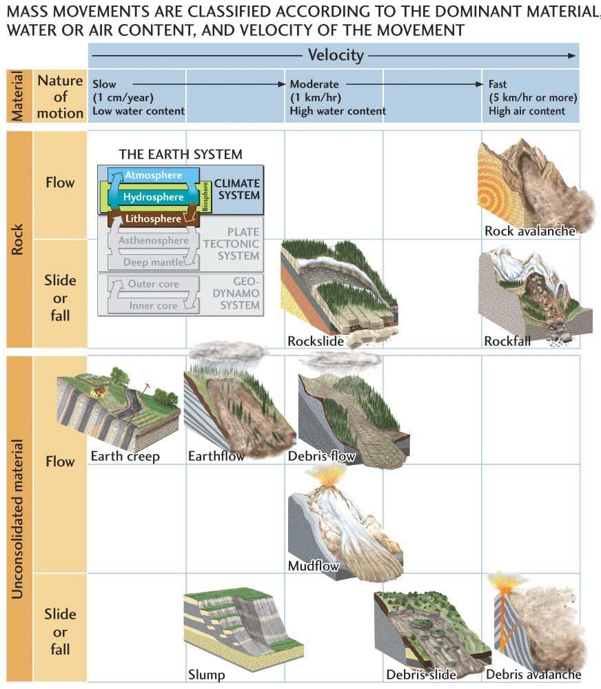
3 Classification of Mass Wasting Mass wasting events are classified by: Nature of material (consolidated or unconsolidated) Speed (few cm/yr to km/hour). Nature of movement (as one unit or as a fluid)
4
5 Mass Wasting classification

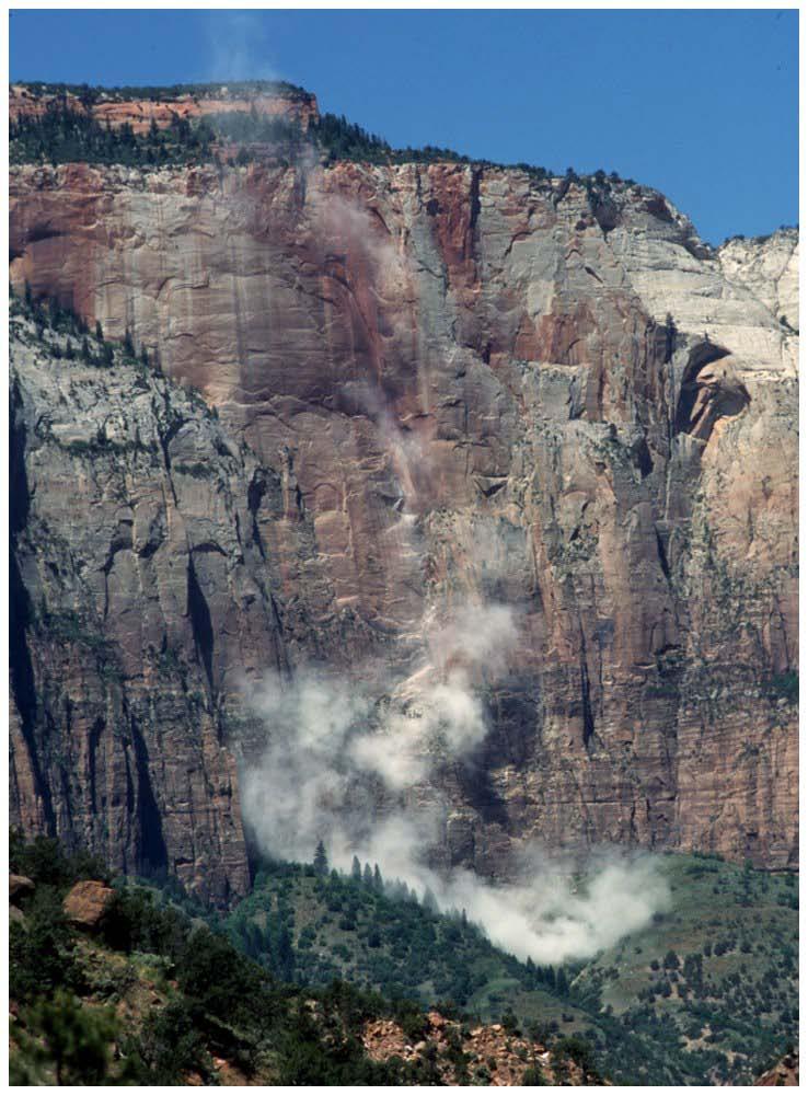
6 Rock Fall Fig 12.7
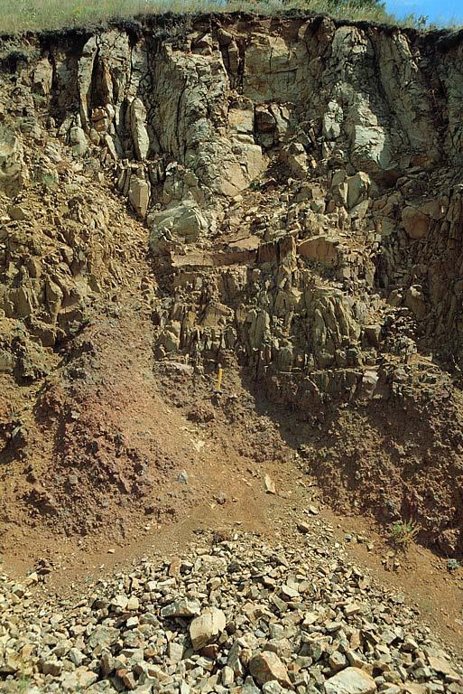
7 Talus

8 Soil Creep Fig 12.10

9 Pistol Butt Trees

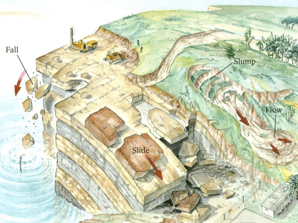
10 Classification Slide - Single mass of rock or sediment is released and moves rapidly along a plane of weakness.
 (\"Grow-Vaunt\") Fig 12.16")
11 Rock Slide Gros Ventre, Wyoming (1925) ("Grow-Vaunt") Fig 12.16


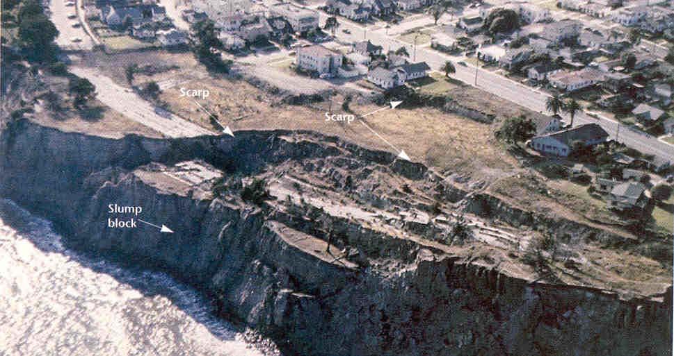

12 What type of mass wasting? Slump

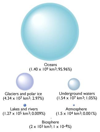
13 Slump near Naches, Washington S. Kuehn
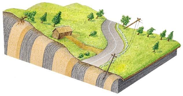
14 What should you look for as indicators of potential problems? evidence of prior mass wasting hummocky topography, irregular surface, scars on mountain side, accumulation of rock and unconsolidated material at base of slope open cracks on the surface look for planes of weakness (beds parallel valley wall) unnatural steep slopes
15 Structural damage Settling and cracking of building foundations Toppling, bowed, or pistol-butt trees Gullying and surface erosion Springs -- Mid-slope ground-water seepage from the bluff face;
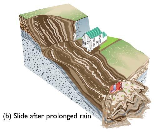
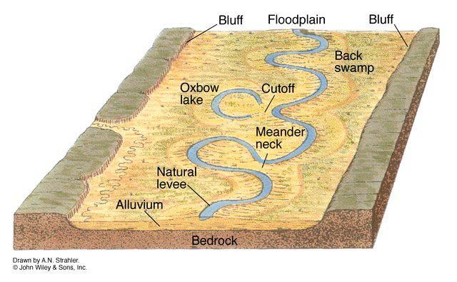
16 Triggers 1. Heavy rain - undercutting slopes by running water - increased weigh of wet soil - increased fluid pressure reduces frictional resistance 2. Earthquakes - ground shaking can trigger landslides
17 Triggers 3. Volcanoes - ground shaking can trigger landslides
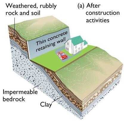
18 Triggers 4. Human activity
19 Triggers
20 Chapter 14 Running Water: The Geology of Streams and Floods
21 Water reservoirs
22 Stream Channel Patterns Straight Braided Meandering

23 Braided River: High-sediment load, high velocity
24 Meandering Channel Meander to wander One main (trunk) channel that winds back and forth across the floodplain. Forms on low slopes through easily eroded bedrock.
25 Meandering River Cut Bank Point Bar
 Cut Bank Point Bar Cut")
26 Meandering Stream (cont.) Cut Bank Point Bar Cut Bank

27 Morphology of a river system

28 Life stages of a river Youthful Mature Mature
29 Old age

30 What is the life stage of this river?
31 Drainage Patterns Drainage controlled by underlying structures. Dendritic = Flat Lying Layers Trellis = Folded Rock Layers Rectangular = Joints or Faults Radial = High Mtn. Peak (Volcanoes)

32 Dendritic drainage Fig 14.20
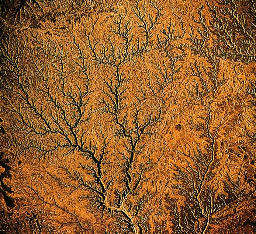
33

34 Rectangular drainage Fig 14.20

35 Note rectangular change in river path

36 Trellis drainage Fig 14.20

37 Trellis drainage

38 Radial drainage Fig 14.20

39 Radial drainage

40 Other Features of Streams


41 Profile View Other Features of Streams Terraces Mark previous level of floodplain. Formed by renewed down cutting to lower base level. Fig 14.17
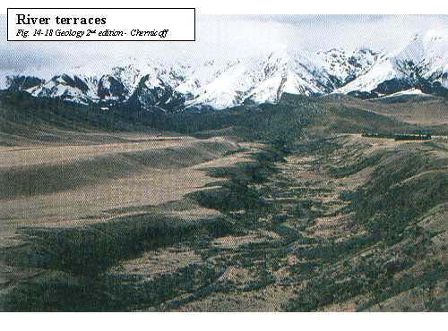
42

43 Alluvial Fan
44 Delta
45 Chapter 16 A Hidden Reserve: Groundwater

46 Water table boundary between unsaturated and saturated zone Fig 13.8
 space in sediment or rock.")
47 How does it get there? Porosity Total volume of pore (void) space in sediment or rock. May be fractures within rock or spaces between grains.

48 How does it get there? Permeability The ability of water to flow through spaces in rock or sediment. (Spaces must be connected!)
49 Groundwater Storage Aquifer material (sediment and rock) that store and transmit groundwater in sufficient quantities. High porosity and high permeability. Rock types? unconsolidated gravel, sand consolidated sandstone, conglomerate
50 Groundwater Storage Aquicludes (also called Aquitards or Confining Beds) Beds/Rocks through which water cannot move, or moves very slowly. Low Permeability (Porosity varies). Rock Types? unconsolidated mud, clay consolidated mudstone, shale, slate
51 The two types of aquifers are: Unconfined aquifer - open to the surface (unsaturated zone and saturated zone) with a water table Confined aquifer is sandwiched between two aquicludes and is not open to the surface at that location Any rock type can be considered an aquifer if it is fractured and the fractures are interconnected!

52 Groundwater storage Unconfined aquifer Confined aquifer Aquiclude Aquifer

53 Groundwater storage Artesian Well Confined Aquifer Fig


54 Springs: Where the surface intersects the water table

55 Geysers: Intermittent hot fountains/columns of water
56 Managing Groundwater Groundwater Withdraw is greater than Groundwater Recharge Cone of Depression Excessive pumping draws down the water table into a cone-shaped depression around a pumping well.

57 Think of a ice cream shake or malt as an analogy. When a well pumps water out of an unconfined aquifer faster than recharge can replenish it, the water level in the aquifer is lowered in a cone-shaped area around the well, called a cone of depression Fig

58 Saltwater Intrusion
59 Managing Groundwater Groundwater Withdraw is greater than Groundwater Recharge Subsidence When water is removed from pore spaces/cracks in sediment/rocks, the weight of overlying materials causes compaction, and sinking of land surface.

60 Subsidence


61 Subsidence (from pumping out water faster than replenishing)
62 Erosion by Groundwater Dissolution Chemical weathering process by which slightly acidic water dissolves rock. Most commonly limestone Water picks up CO 2 from the atmosphere and from the soil and becomes slightly acidic (carbonic acid). Acid is strongest at the level of the water table. Dissolves along fractures, enlarging them into a network of caves and other features called Karst.

63 Karst topography Limestone is subjected to chemical weathering Fig 13.19
64 Cave Formation Cave Formation 1. Dissolution occurs near the water table, enlarging previous fractures. 2. Water table drops - leaves a cavity full of air 3. Water infiltrates from above and minerals precipitate as water enters void space. 4. Minerals (Calcite) precipitate as formations known as speleothems. Website for virtual cave:

65 Speleothems Stalactite Column Stalagmite

66 Sinkhole in Winter Park, Florida This sinkhole was created when the roof of a cave collapsed. Collapse can happen very quickly and suddenly. Fig Understanding Earth
67 Contamination of our Water Supply Groundwater Pollutants - Sewage - Leaking gasoline tanks - Pesticide / Herbicides / Fertilizer - Feed lots - Cleaning solvents - Radioactive waste

68 Contamination of Water Supply
69 Groundwater review What are some materials that form aquifers? What are some materials that form aquitards? What is an unconfined aquifer? What is a confined aquifer? What creates a spring? What rock type are dissolution caves formed in?
70 Consider the following questions: You bought a piece of land in the country to build your house; you need both a water well and a septic system. Where are you going to put them? Where would you go for information to insure that you have a safe water supply? You just bought a house in the country, the water tastes a little strange. What are you going to do?
71 Chapter 15 Restless Realm: Oceans and Coasts

72 Major Physiographic Features in the Atlantic Ocean continental margin continental shelf continental slope continental rise abyssal plain seamounts and guyots amid-ocean ridge abyssal hills central rift valley

73 Abyssal Hills Linear ridges of basalt covered with a thin veneer of deep-sea sediment on the flanks of the Mid-ocean ridge. 2-km high submarine mountain belt Abyssal plain Abyssal hills Fig. 17.5
")


74 Waves are due to wind Higher waves can be caused by: 1) Higher wind speed 2) Increased storm duration (time) 3) Longer fetch (distance over which wind blows) Indian ocean

75 Wave characteristics Wave length distance between crests Wave height vertical distance between crest and trough Period time between successive waves to pass Wave base is 1/2 wave length there is negligible water movement due to waves below this depth wave height

.")
76 How do breakers form? As the swell approaches the shore where the bottom shallows to less than ½ the wavelength, the wave touch bottom causing it to slow the wave period remains the same so the wavelength decreases and the waves height increase (making the wave steeper). As bottom shallows further the water can no longer support itself and the waves breaks and crashes in the surf zone

77 Major Parts of a Beach Surf zone offshore belt along which breaking waves collapse as they approach the shore Swash zone - zone where water run up on the beach from a wave Tidal flats the area that lie above low tide but are flooded at high tide


78 Formation of rip -- rapid current draining beach area through shallow nearshore bars -- fast and dangerous (most beach rescues) What do you do if caught in a rip current? currents

79 Far from shore the lines of swells are parallel to each other but are usually at some angel to the shoreline. Wave refraction occurs as waves slow down in progressively more shallow water depths allowing the wave fronts to bend and approach the shore nearly parallel. Fig. Story 17.13

80 Wave refraction moves sediment along the beach in a zigzag motion known as longshore drift.

81 Many coastal depositional features are formed by longshore drift. The River of Sand


82 San Diego spit Sand spit Sand Spits End of a spit -- common wherever sand is supplied and a longshore current is present


83 Tombolos -- island shields beach from wave energy -- leads to sand build up

84 Emergent coasts -- uplifted, tectonically active coasts often rocky -- rocky headlands alternate with pocket beaches -- formed by wave erosion


85 Wave cut platforms -- abrasion across surf zone erodes bedrock flat common feature on rocky coasts


86 Sea stacks and arches - remnants of erosion


87 Uplifted beach terraces -- can be either wave cut platforms or beaches or both -- common on emergent coasts -- EX:, CA, OR, WA, entire west coast of US


88 Preventing beach erosion Structural approaches (e.g., groins, breakwater, jetties): typically cause increased erosion down-current of structure Non-structural approaches (e.g., beach nourishment, land use planning): expensive, but doesn t cause erosion in new areas Groins - catch part of the river of sand from longshore drift Breakwater - reduces local wave energy so sand is deposited, not carried away


89 Groins- which direction is sand flowing? New Jersey groins Groins and breakwaters Italian breakwater
In 1990, 50% of the U.S. population lived within 75 km of a coast. By 2010, 75% of the U.S. population will live within 75 km of a coast.
 In 1990, 50% of the U.S. population lived within 75 km of a coast. By 2010, 75% of the U.S. population will live within 75 km of a coast. High Tech Methods for Surveying the Deep Sea Floor Fig. 20.18 1
The Marine Environment
 The Marine Environment SECTION 16.1 Shoreline Features In your textbook, read about erosional landforms, beaches, estuaries, longshore currents, and rip currents. For each statement below, write or. 1.
Erosion and Deposition
 Erosion and Deposition Erosion Sediment natural forces move rock/soil from one place to another. gravity, water, wind, glaciers, waves are causes material moved by erosion Deposition when erosion lays
The Marine Environment
 The Marine Environment SECTION 16.1 Shoreline Features In your textbook, read about erosional landforms, beaches, estuaries, longshore currents, and rip currents. For each statement below, write true or
 12 10 8 6 4 2 0 40-50 50-60 60-70 70-80 80-90 90-100 Fresh Water What we will cover The Hydrologic Cycle River systems Floods Groundwater Caves and Karst Topography Hot springs Distribution of water in
6.1 Water. The Water Cycle
 6.1 Water The Water Cycle Water constantly moves among the oceans, the atmosphere, the solid Earth, and the biosphere. This unending circulation of Earth s water supply is the water cycle. The Water Cycle
Earth Science Chapter 9. Day 6 - Finish Capillary Action Lab - Quiz over Notes - Review Worksheets over Sections 9.2 and 9.3
 Earth Science Chapter 9 Day 1 Day 2 Day 3 Read Section 9.1 Surface Water Chapter 9 Term Sheet Notes over Section 9.1 Surface Water Section 9.1 Review Worksheets Quiz over Section 9.1 Notes Virtual Lab
What we will cover. The Hydrologic Cycle. River systems. Floods. Groundwater. Caves and Karst Topography. Hot springs
 Fresh Water What we will cover The Hydrologic Cycle River systems Floods Groundwater Caves and Karst Topography Hot springs On a piece of paper, put these reservoirs of water in to order from largest to
What is weathering and how does it change Earth s surface? Answer the question using
 7 th Grade Lesson What is weathering and how does it change Earth s surface? Answer the question using the sentence frame. You have 4 minutes. Weathering is. This changes the Earth s surface because. 1
Prentice Hall EARTH SCIENCE
 Prentice Hall EARTH SCIENCE Tarbuck Lutgens Running Water and Groundwater Running Water The Water Cycle Water constantly moves among the oceans, the atmosphere, the solid Earth, and the biosphere. This
Chapter 14. Groundwater
 Chapter 14 Groundwater Importance of groundwater! Groundwater is water found in the pores of soil and sediment, plus narrow fractures in bedrock! Groundwater is the largest reservoir of fresh water that
1/6/ th Grade Earth s Surface. Chapter 3: Erosion and Deposition. Lesson 1 (Mass Movement)
") Lesson 1 (Mass Movement) 7 th Grade Earth s Surface Chapter 3: Erosion and Deposition Weathering the chemical and physical processes that break down rock at Earth s surface Mechanical weathering when rock
Lesson 1 (Mass Movement) 7 th Grade Earth s Surface Chapter 3: Erosion and Deposition Weathering the chemical and physical processes that break down rock at Earth s surface Mechanical weathering when rock
Surface Water and Stream Development
 Surface Water and Stream Development Surface Water The moment a raindrop falls to earth it begins its return to the sea. Once water reaches Earth s surface it may evaporate back into the atmosphere, soak
Surface Processes Focus on Mass Wasting (Chapter 10)
") Surface Processes Focus on Mass Wasting (Chapter 10) 1. What is the distinction between weathering, mass wasting, and erosion? 2. What is the controlling force in mass wasting? What force provides resistance?
Surface Processes Focus on Mass Wasting (Chapter 10) 1. What is the distinction between weathering, mass wasting, and erosion? 2. What is the controlling force in mass wasting? What force provides resistance?
WATER ON AND UNDER GROUND. Objectives. The Hydrologic Cycle
 WATER ON AND UNDER GROUND Objectives Define and describe the hydrologic cycle. Identify the basic characteristics of streams. Define drainage basin. Describe how floods occur and what factors may make
Lecture Outlines PowerPoint. Chapter 5 Earth Science 11e Tarbuck/Lutgens
 Lecture Outlines PowerPoint Chapter 5 Earth Science 11e Tarbuck/Lutgens 2006 Pearson Prentice Hall This work is protected by United States copyright laws and is provided solely for the use of instructors
EROSION AND DEPOSITION
 CHAPTER 8 EROSION AND DEPOSITION SECTION 8 1 Changing Earth s Surface (pages 252-255) This section explains how sediment is carried away and deposited elsewhere to wear down and build up Earth s surface.
Erosion and Deposition
 CHAPTER 3 LESSON 2 Erosion and Deposition Landforms Shaped by Water and Wind Key Concepts What are the stages of stream development? How do water erosion and deposition change Earth s surface? How do wind
STUDY GUIDE FOR CONTENT MASTERY. Movement and Storage of Groundwater
 Groundwater SECTION 10.1 Movement and Storage of Groundwater In your textbook, read about the hydrosphere, precipitation and groundwater, and groundwater storage. Use the following terms to complete the
RIVERS, GROUNDWATER, AND GLACIERS
 RIVERS, GROUNDWATER, AND GLACIERS Delta A fan-shaped deposit that forms when a river flows into a quiet or large body of water, such as a lake, an ocean, or an inland sea. Alluvial Fan A sloping triangle
Chapter 3 Erosion and Deposition. The Big Question:
 Chapter 3 Erosion and Deposition The Big Question: 1 Design a way to represent and describe the 4 types of mass movement. You may use pictures, diagrams, list, web, chart, etc 2 Chapter 3: Erosion and
Changing Earth s Surface
 Name Date Class Changing Earth s Surface What processes wear down and build up Earth s surface? What causes the different types of mass movement? Erosion is the process by which natural forces move weathered
Pratice Surface Processes Test
 1. The cross section below shows the movement of wind-driven sand particles that strike a partly exposed basalt cobble located at the surface of a windy desert. Which cross section best represents the
Prof. Stephen A. Nelson EENS 111. Groundwater
 Page 1 of 8 Prof. Stephen A. Nelson EENS 111 Tulane University Physical Geology This page last updated on 20-Oct-2003 is water that exists in the pore spaces and fractures in rock and sediment beneath
Essentials of Geology, 11e
 Essentials of Geology, 11e Groundwater Chapter 10 Instructor Jennifer Barson Spokane Falls Community College Geology 101 Stanley Hatfield Southwestern Illinois Co Jennifer Cole Northeastern University
Weathering, Erosion, Deposition
 Weathering, Erosion, Deposition The breakdown of rocks at or near the Earth s Surface. Physical Chemical - The breakdown of rock into smaller pieces without chemical change. - Dominant in moist /cold conditions
Geol 117 Lecture 18 Beaches & Coastlines. I. Types of Coastlines A. Definition:
 I. Types of Coastlines A. Definition: 1. Shore = narrow zone where ocean meets land (e.g. beach) 2. Coast is a broad area where both ocean and land processes act a. Includes onshore marshes, dunes, sea
Streams. Water. Hydrologic Cycle. Geol 104: Streams
 Streams Why study streams? Running water is the most important geologic agent in erosion, transportation and deposition of sediments. Water The unique physical and chemical properties of water make it
The Coast: Beaches and Shoreline Processes
 1 2 3 4 5 6 7 8 9 The Coast: es and Shoreline Processes Trujillo & Thurman, Chapter 10 Oceanography 101 Chapter Objectives Recognize the various landforms characteristic of beaches and coastal regions.
The Coast: Beaches and Shoreline Processes Trujillo & Thurman, Chapter 10
 The Coast: es and Shoreline Processes Trujillo & Thurman, Chapter 10 Oceanography 101 Chapter Objectives Recognize the various landforms characteristic of beaches and coastal regions. Identify seasonal
Chapter 13. Groundwater
 Chapter 13 Groundwater Introduction Groundwater is all subsurface water that completely fills the pores and other open spaces in rocks, sediments, and soil. Groundwater is responsible for forming beautiful
What is a water table? What is an aquifer? What is the difference between a spring and a well?
 CHAPTER 11 3 Water Underground SECTION The Flow of Fresh Water BEFORE YOU READ After you read this section, you should be able to answer these questions: What is a water table? What is an aquifer? What
Weathering of Rocks. Weathering - Breakdown of rocks into pieces (sediment) 2 main types of weathering to rocks
 2 main types of weathering to rocks") Weathering of Rocks Weathering - Breakdown of rocks into pieces (sediment) 2 main types of weathering to rocks Mechanical weathering requires physical forces to break rocks into smaller pieces. Chemical
Weathering of Rocks Weathering - Breakdown of rocks into pieces (sediment) 2 main types of weathering to rocks Mechanical weathering requires physical forces to break rocks into smaller pieces. Chemical
What are the different ways rocks can be weathered?
 Romano - 223 What are the different ways rocks can be weathered? Weathering - the breakdown of rocks and minerals at the Earth s surface 1. 2. PHYSICAL WEATHERING Rock is broken into smaller pieces with
10/27/2014. Surface Processes. Surface Processes. Surface Processes. Surface Processes. Surface Processes
 Hewitt/Lyons/Suchocki/Yeh Conceptual Integrated Science Chapter 25 Surface or surficial processes originate at Earth's surface and reshape its contours. Surface processes include: Weathering Erosion Deposition
Chapter 14: Groundwater. Fig 14.5b
 Chapter 14: Groundwater Fig 14.5b OBJECTIVES Recognize that groundwater is a vital source of accessible freshwater. Describe how groundwater forms below the water table. Explain the origin of aquifers,
Weathering, Erosion, Deposition, and Landscape Development
 Weathering, Erosion, Deposition, and Landscape Development I. Weathering - the breakdown of rocks into smaller particles, also called sediments, by natural processes. Weathering is further divided into
27. Running Water I (p ; )
") 27. Running Water I (p. 424-436; 440-444) Hydrosphere How much of the Earth s surface is covered by water? Earth's water is collectively called the and is stored in a number of so-called as follows: 1.
27. Running Water I (p. 424-436; 440-444) Hydrosphere How much of the Earth s surface is covered by water? Earth's water is collectively called the and is stored in a number of so-called as follows: 1.
Chapter 10. Running Water aka Rivers. BFRB Pages
 Chapter 10 Running Water aka Rivers BFRB Pages 101-116 Stream Erosion and Transportation Running water is all precipitation (rain, snow, etc) that falls on Earth and is pulled downhill by gravity. Running
Topic 6: Weathering, Erosion and Erosional-Deposition Systems (workbook p ) Workbook Chapter 4, 5 WEATHERING
 Workbook Chapter 4, 5 WEATHERING") Topic 6: Weathering, Erosion and Erosional-Deposition Systems (workbook p. 95-125) Workbook Chapter 4, 5 THE BIG PICTURE: Weathering, erosion and deposition are processes that cause changes to rock material
Topic 6: Weathering, Erosion and Erosional-Deposition Systems (workbook p. 95-125) Workbook Chapter 4, 5 THE BIG PICTURE: Weathering, erosion and deposition are processes that cause changes to rock material
EARTH S CHANGING SURFACE
 EARTH S CHANGING SURFACE Weathering Together, weathering and erosion work continuously to wear down the material on Earth s surface. weathering process that breaks down rock and other substances of Earth
1. Erosion by Running Water Most powerful cause of erosion
 I. Destructive Forces Notes: Destructive force: a process in which land is destroyed or changed such as weathering and erosion. All landforms are a result of a combination of constructive and destructive
Mass Wasting. Revisit: Erosion, Transportation, and Deposition
 Mass Wasting Revisit: Erosion, Transportation, and Deposition While landslides are a normal part of erosion and surface processes, they can be very destructive to life and property! - Mass wasting: downslope
Page 1. Name:
 Name: 1) Which event is the best example of erosion? dissolving of rock particles on a limestone gravestone by acid rain breaking apart of shale as a result of water freezing in a crack rolling of a pebble
Chapter 17. Ocean and Coastal Processes
 Chapter 17 Ocean and Coastal Processes Ocean Basins and Plates Ocean Basins Ocean Basins are profoundly different from the continents. Ocean crust is thin and dense and young. New ocean crust is generated
UNIT 4: Earth Science Chapter 21: Earth s Changing Surface (pages )
") CORNELL NOTES Directions: You must create a minimum of 5 questions in this column per page (average). Use these to study your notes and prepare for tests and quizzes. Notes will be turned in to your teacher
CORNELL NOTES Directions: You must create a minimum of 5 questions in this column per page (average). Use these to study your notes and prepare for tests and quizzes. Notes will be turned in to your teacher
Unit 1: Water Systems on Earth Chapter 2
 Unit 1: Water Systems on Earth Chapter 2 Create a mind map with the driving question, Why are Oceans Important? Remember: Why are oceans so important? Why are oceans so important? Primary water source
Supplemental Slides. Shore: Junction of Land & Water. Junction of Land & Water. Sea Level Variations. Shore vs. Coast. Sea Level Variations
 Shore: Junction of Land & Water Supplemental Slides Sediments come off land Most get dumped at the beach Sediment interacts with ocean waves and currents Junction of Land & Water Features: Breaking waves,
Shore: Junction of Land & Water. Sediments come off land Most get dumped at the beach Sediment interacts with ocean waves and currents
 Shore: Junction of Land & Water Supplemental Slides Sediments come off land Most get dumped at the beach Sediment interacts with ocean waves and currents Junction of Land & Water Features: Breaking waves,
Section I: Multiple Choice Select the best answer to each question. Mark your final answer on the answer sheet. (1 pt each)
") Sedimentary Rocks & Surface Processes Quest Name: Earth Science 2013 Block: Date: Section I: Multiple Choice Select the best answer to each question. Mark your final answer on the answer sheet. (1 pt each)
Sedimentary Rocks & Surface Processes Quest Name: Earth Science 2013 Block: Date: Section I: Multiple Choice Select the best answer to each question. Mark your final answer on the answer sheet. (1 pt each)
Example Quiz on Earthquakes
 Example Quizzes, Tests, and Review Information A Example Quiz on Earthquakes Quizzes such as this one are given at the beginning of each lab. 1. The point beneath the Earth s surface at which an earthquake
Earth Science Lesson Plan Quarter 2, Week 10, Day 1
 Earth Science Lesson Plan Quarter 2, Week 10, Day 1 Outcomes for Today Standard Focus: PREPARE 1. Background knowledge necessary for today s reading. Beaches are created by the actions of waves, tides,
Ocean and Coastal Processes. Ocean Basins. Chapter 20. Ocean Basins and Plates. Ocean Terms. Sea Arch Bay-mouth Bar Spit Tombolo Coast.
 Chapter 20 Ocean Basins and Plates Ocean and Coastal Processes Tide Wave Height Length Period Base Refraction Tsunami Beach Sea stack Ocean Terms Sea Arch Bay-mouth Bar Spit Tombolo Coast Emergent Submergent
Objectives. Vocabulary
 Shoreline Features Objectives Explain how shoreline features are formed and modified by marine processes. Describe the major erosional and depositional shoreline features. Vocabulary wave refraction beach
Groundwater. (x 1000 km 3 /y) Reservoirs. Oceans Cover >70% of Surface. Groundwater and the. Hydrologic Cycle
 Reservoirs. Oceans Cover >70% of Surface. Groundwater and the. Hydrologic Cycle") Chapter 13 Oceans Cover >70% of Surface Groundwater and the Hydrologic Cycle Oceans are only 0.025% of Mass Groundwater Groundwater is liquid water that lies in the subsurface in fractures in rocks and
Chapter 13 Oceans Cover >70% of Surface Groundwater and the Hydrologic Cycle Oceans are only 0.025% of Mass Groundwater Groundwater is liquid water that lies in the subsurface in fractures in rocks and
Essential Questions. What is erosion? What is mass wasting?
 Erosion Essential Questions What is erosion? What is mass wasting? What is Erosion? Erosion The transportation of sediment from one area to another Caused mainly by running water but also caused by glaciers,
Surface Events & Landforms. Mrs. Green
 Surface Events & Landforms Mrs. Green Bell Work 1) Which event MOST likely causes the slowest change to the surface of Earth? a) Earthquake b) Landslide c) Volcano d) Wind 2) When cold weather freezes
Erosion Surface Water. moving, transporting, and depositing sediment.
 + Erosion Surface Water moving, transporting, and depositing sediment. + Surface Water 2 Water from rainfall can hit Earth s surface and do a number of things: Slowly soak into the ground: Infiltration
SLOPE FAILURE SLOPES. Landslides, Mudflows, Earthflows, and other Mass Wasting Processes
 GEOL g406 Environmental Geology SLOPE FAILURE Landslides, Mudflows, Earthflows, and other Mass Wasting Processes Read Chapter 5 in your textbook (Keller, 2000) Gros Ventre landslide, Wyoming S. Hughes,
Water on the Earth. The distribution of all the water found on the earth's surface.
 Earth s Waters This is one of the water canals of the present-day system in Phoenix, Arizona. These canals were reconstructed from a system that was built by American Indians, then abandoned. Phoenix is
THE SCIENCE OF MAPS. ATL Skill: Critical thinking - Use models and simulations to explore complex systems and issues
 THE SCIENCE OF MAPS 8.9C interpret topographic maps and satellite views to identify land and erosional features and predict how these features may be reshaped by weathering ATL Skill: Critical thinking
WEATHERING, EROSION & DEPOSITION STUDY GUIDE
 WEATHERING, EROSION & DEPOSITION STUDY GUIDE Weathering: The difference between mechanical & chemical weathering is: Sort terms as being mechanical/physical or chemical weathering: acid rain, root splitting
11/12/2014. Running Water. Introduction. Water on Earth. The Hydrologic Cycle. Fluid Flow
 Introduction Mercury, Venus, Earth and Mars share a similar history, but Earth is the only terrestrial planet with abundant water! Mercury is too small and hot Venus has a runaway green house effect so
8UNIT. External dynamics of the Earth. What do you remember? Key language. Content objectives
 8UNIT External dynamics of the Earth What do you remember? Can you name the solids in the photograph? nd the liquid? Is the liquid moving? How does it move? What is the name of this formation of water?
PHYSICAL GEOGRAPHY. By Brett Lucas
 PHYSICAL GEOGRAPHY By Brett Lucas FLUVIAL PROCESSES Fluvial Processes The Impact of Fluvial Processes on the Landscape Streams and Stream Systems Stream Channels Structural Relationships The Shaping and
Read Across America. Listen as I read for facts about Volcanoes. In the Shadow of the Volcano
 Read Across America Listen as I read for facts about Volcanoes. In the Shadow of the Volcano Constructive & Destructive Processes Earth s surface is always changing. Blowing wind and flowing water causes
Water Erosion (pages )
") Water Erosion (pages 272 281) Runoff and Erosion (pages 273 274) Key Concept: Moving water is the major agent of the erosion that has shaped Earth s land surface. Falling raindrops can loosen and pick
Water Erosion (pages 272 281) Runoff and Erosion (pages 273 274) Key Concept: Moving water is the major agent of the erosion that has shaped Earth s land surface. Falling raindrops can loosen and pick
Pre-Lab Reading Questions ES202
 ES202 The are designed to encourage students to read lab material prior to attending class during any given week. Reading the weekly lab prior to attending class will result in better grade performance
mountain rivers fixed channel boundaries (bedrock banks and bed) high transport capacity low storage input output
 high transport capacity low storage input output") mountain rivers fixed channel boundaries (bedrock banks and bed) high transport capacity low storage input output strong interaction between streams & hillslopes Sediment Budgets for Mountain Rivers Little
mountain rivers fixed channel boundaries (bedrock banks and bed) high transport capacity low storage input output strong interaction between streams & hillslopes Sediment Budgets for Mountain Rivers Little
Section 11.1 pp Where Mountains Form
 Section 11.1 pp. 236 237 Where Mountains Form Chapter 11 Set a Purpose: TE, p. 236 Reading Study Guide, p. 36 Discussion: TE, p. 236 Differentiating ion Reading Support: TE, p. 236 Visual Teaching Interpret
1 Shoreline Landforms 2. 2 Emergent v. Submergent 2. 3 Wavecutting 3. 4 Planview 4. 5 Marine Terraces 5. 6 California 7. 7 Tombolos, Sea Stacks 8
 Shorelines November 9, 2008 Contents 1 Shoreline Landforms 2 2 Emergent v. Submergent 2 3 Wavecutting 3 4 Planview 4 5 Marine Terraces 5 6 California 7 7 Tombolos, Sea Stacks 8 8 Active Processes 9 9 Emergence
1. Any process that causes rock to crack or break into pieces is called physical weathering. Initial product = final product
 Weathering 1. Any process that causes rock to crack or break into pieces is called physical weathering. Initial product = final product End Result of physical weathering is increased surface area. 2. Physical
1 Water Beneath the Surface
 CHAPTER 16 1 Water Beneath the Surface SECTION Groundwater KEY IDEAS As you read this section, keep these questions in mind: What are two properties of aquifers? How is the water table related to the land
SHORELINE AND BEACH PROCESSES: PART 2. Implications for Coastal Engineering
 SHORELINE AND BEACH PROCESSES: PART 2 Implications for Coastal Engineering Objectives of the lecture: Part 2 Show examples of coastal engineering Discuss the practical difficulties of ocean engineering
UNIT 1: WATER SYSTEMS ON EARTH CHAPTER 2: OCEANS CONTROL THE WATER CYCLE
 UNIT 1: WATER SYSTEMS ON EARTH CHAPTER 2: OCEANS CONTROL THE WATER CYCLE ORIGINS OF OCEAN WATER OCEANS HAVE FILLED OVER HUNDREDS OF MILLIONS OF YEARS SCIENTISTS BELIEVE THE OCEANS ARE MORE THAN 3 BILLION
Continental Landscapes
 Continental Landscapes Landscape influenced by tectonics, climate & differential weathering Most landforms developed within the last 2 million years System moves toward an equilibrium Continental Landscapes
Name. 4. The diagram below shows a soil profile formed in an area of granite bedrock. Four different soil horizons, A, B, C, and D, are shown.
 Name 1. In the cross section of the hill shown below, which rock units are probably most resistant to weathering? 4. The diagram below shows a soil profile formed in an area of granite bedrock. Four different
water erosion lithosphere Describe the process of erosion and deposition. chemical weathering Dissolving limestone is an example of.
 At one time, there was one large island off the coast of Mississippi and now it is two separate islands. What caused the island to be split into two? water erosion The crust and the top part of the upper
1. The map below shows a meandering river. A A' is the location of a cross section. The arrows show the direction of the river flow.
 1. The map below shows a meandering river. A A' is the location of a cross section. The arrows show the direction of the river flow. Which cross section best represents the shape of the river bottom at
TEACHER BACKGROUND KNOWLEDGE. Surface Processes: Weathering and Erosion
 TEACHER BACKGROUND KNOWLEDGE Surface Processes: Weathering and Erosion Core Concepts Precipitation (caused by the water cycle) and wind cause rocks to be broken into smaller pieces in the process called
4. The map below shows a meandering stream. Points A, B, C, and D represent locations along the stream bottom.
 1. Sediment is deposited as a river enters a lake because the A) velocity of the river decreases B) force of gravity decreases C) volume of water increases D) slope of the river increases 2. Which diagram
Science 8 - Water Systems Test - Chapters 1-2
 Science 8 - Water Systems Test - Chapters 1-2 Multiple Choice (30 marks) Identify the choice that best completes the statement or answers the question. 1. What percentage represents the amount of fresh
Chapter 2. Wearing Down Landforms: Rivers and Ice. Physical Weathering
 Chapter 2 Wearing Down Landforms: Rivers and Ice Physical Weathering Weathering vs. Erosion Weathering is the breakdown of rock and minerals. Erosion is a two fold process that starts with 1) breakdown
Which map shows the stream drainage pattern that most likely formed on the surface of this volcano? A) B)
 B)") 1. When snow cover on the land melts, the water will most likely become surface runoff if the land surface is A) frozen B) porous C) grass covered D) unconsolidated gravel Base your answers to questions
1. When snow cover on the land melts, the water will most likely become surface runoff if the land surface is A) frozen B) porous C) grass covered D) unconsolidated gravel Base your answers to questions
Erosion and Deposition
 Erosion and Deposition The Erosion-Deposition Process What do you think? Read the two statements below and decide whether you agree or disagree with them. Place an A in the Before column if you agree with
1 Shoreline Erosion and Deposition
 CHAPTER 12 1 Shoreline Erosion and Deposition SECTION Agents of Erosion and Deposition BEFORE YOU READ After you read this section, you should be able to answer these questions: What is a shoreline? How
Groundwater. (x 1000 km 3 /y) Oceans Cover >70% of Surface. Groundwater and the. Hydrologic Cycle
 Oceans Cover >70% of Surface. Groundwater and the. Hydrologic Cycle") Chapter 17 Oceans Cover >70% of Surface Groundwater and the Hydrologic Cycle Vasey s Paradise, GCNP Oceans are only 0.025% of Mass Groundwater Groundwater is liquid water that lies in the subsurface in
Chapter 17 Oceans Cover >70% of Surface Groundwater and the Hydrologic Cycle Vasey s Paradise, GCNP Oceans are only 0.025% of Mass Groundwater Groundwater is liquid water that lies in the subsurface in
Section 2.1 Ocean Basins. - Has helped determine where ocean basins are located. - Tectonic plates move changing the position of the continents.
 Science 8 Unit 1: Water Systems on Earth Chapter 2: Oceans Control the Water Cycle Section 2.1 Ocean Basins Oceans are important because: 1. Primary water source for the water cycle 2. Control weather
TAKE HOME EXAM 8R - Geology
 Name Period Date TAKE HOME EXAM 8R - Geology PART 1 - Multiple Choice 1. A volcanic cone made up of alternating layers of lava and rock particles is a cone. a. cinder b. lava c. shield d. composite 2.
GEOG 1010A. Come to the PASS workshop with your mock exam complete. During the workshop you can work with other students to review your work.
 It is most beneficial to you to write this mock midterm UNDER EXAM CONDITIONS. This means: Complete the midterm in 1.5 hours. Work on your own. Keep your notes and textbook closed. Attempt every question.
A physical feature of the Earth s surface
 Earth s Landforms A physical feature of the Earth s surface A physical feature of the Earth s surface LANDFORM Highest of Earth s physical features Highest of Earth s physical features MOUNTAIN Low area
GEOL 1121 Earth Processes and Environments
 GEOL 1121 Earth Processes and Environments Wondwosen Seyoum Department of Geology University of Georgia e-mail: seyoum@uga.edu G/G Bldg., Rm. No. 122 Seyoum, 2015 Chapter 6 Streams and Flooding Seyoum,
EARTH SCIENCE 11 CHAPTER 9 NOTES WATER MOVING UNDERGROUND
 EARTH SCIENCE 11 CHAPTER 9 NOTES WATER MOVING UNDERGROUND KEY A. ALL THE WORLD S WATER 1. The world has an estimated one and one third thousand million cubic kilometers of water. 2. The earth s water is
use Chapter 5 The Wrath of Vulcan: Volcanic Eruptions Interlude B A surface Veneer: Sediments and Soil
 Study Guide: Lecture Exam 3 - Covers Chapters 1-7, 9,10 (old material) and 13,14,16,18,15,8 and Interlude F,D (new material) in text (Essentials of Geology), lecture and lab material Exam rules: The class
Constructive and Destructive Forces. Processes That Act Upon Earth s Surface Features
 Constructive and Destructive Forces Processes That Act Upon Earth s Surface Features What are Constructive and Destructive Forces? Constructive Force A constructive force is a process that raises or builds
STUDY GUIDE FOR MID-TERM EXAM KEY. Color, luster, cleavage, fracture, hardness, taste, smell, fluorescence, radioactivity, magnetism
 STUDY GUIDE FOR MID-TERM EXAM KEY 1. In which type of rock are fossils most likely to be found? Sedimentary Rocks 2. Which mineral is easily identified by smell? Sulfur 3. Which natural resource makes
River/Stream Erosion Notes
 Name Date ES per Mr. Williams River/Stream Erosion Notes Erosion: the of weathered material. FACT: Running water moves more sediment than ANY other type of erosion. 1. The Water Cycle What happens when
core mantle crust the center of the Earth the middle layer of the Earth made up of molten (melted) rock
 rock") core the center of the Earth mantle the middle layer of the Earth made up of molten (melted) rock crust the surface layer of the Earth that includes the continents and oceans 1 continental drift the theory
core the center of the Earth mantle the middle layer of the Earth made up of molten (melted) rock crust the surface layer of the Earth that includes the continents and oceans 1 continental drift the theory
Figure 1 The map shows the top view of a meandering stream as it enters a lake. At which points along the stream are erosion and deposition dominant?
 1. In which type of climate does chemical weathering usually occur most rapidly? 1. hot and dry 3. cold and dry 2. hot and wet 4. cold and wet 2. Figure 1 The map shows the top view of a meandering stream
STUDY GUIDE FOR CONTENT MASTERY. Surface Water Movement
 Surface Water SECTION 9.1 Surface Water Movement In your textbook, read about surface water and the way in which it moves sediment. Complete each statement. 1. An excessive amount of water flowing downslope