Ocean and Coastal Processes. Ocean Basins. Chapter 20. Ocean Basins and Plates. Ocean Terms. Sea Arch Bay-mouth Bar Spit Tombolo Coast.
|
|
|
- Megan Copeland
- 5 years ago
- Views:
Transcription

1 Chapter 20 Ocean Basins and Plates Ocean and Coastal Processes Tide Wave Height Length Period Base Refraction Tsunami Beach Sea stack Ocean Terms Sea Arch Bay-mouth Bar Spit Tombolo Coast Emergent Submergent Atoll Guyot Ocean Basins Ocean Basins are profoundly different from the continents. Ocean crust is thin and dense and young. New ocean crust is generated at spreading ridges and consumed is subduction zones Ocean Basins Tides Tides are caused by gravitational attraction of the moon and sun. The tidal bulge forms on the side facing the moon and the side away from the moon. If there were no land the tide would pass around the Earth with a 12 h period. The presence of land masses can cancel or multiply the amplitude. 1
 occur when sun and moon are at right angles (first quarter and third quarter moon) Waves Waves are driven primarily by wind.")
 Wave height: Ocean wave heights range from 0.3 to about 5m. Maximum recorded ocean wave height is 34m (100ft).")
2 Tides are caused by Gravitational Attraction of the Sun and Moon Tides Tide maxima (spring tides) occur when sun and moon line up (new moon, full moon). Tide minima (neap tides) occur when sun and moon are at right angles (first quarter and third quarter moon) Waves Waves are driven primarily by wind. Waves may also be generated by earthquakes, submarine landslides and meteorites. Wave height is the vertical distance between crest and trough. Wave length is the horizontal distance between crests. Period is the time between crests. Wave Size (Wind) Wave height: Ocean wave heights range from 0.3 to about 5m. Maximum recorded ocean wave height is 34m (100ft). Wavelength: Ocean wave lengths range from 40 to about 400m. Ocean waves travel at speeds of 25 to about 90 km/h Wavebase The depth at which wave motion ceases Equals about 1/2 wavelength Wave Motion Wave motion of the water extends to about one-half the wavelength (20 to 200m) (wave base). When a wave enters shallow water (<1/2 wavelength), it is slowed by drag. Slowing causes bending of wave parallel to coast (refraction). Breakers are caused by the crest overtaking the trough. Wave Base Wave Motion 2
. This is due to drag on the bottom.")


3 Refraction Refraction Waves travel more slowly in shallow water (shallower than the wave base). This is due to drag on the bottom. This is called refraction This causes the wave front to bend so it is more parallel to shore. It focuses wave energy on headlands. Refraction Wave Refraction Wave Refraction Tsunamis A tsunami is a seismic sea wave caused by an earthquake or submarine landslide. Wave height in deep water of 0.5 to 2 m. Wave height in shallow water up to 50 m. Wavelength of 100 km Wave velocity up to 700 km/h (400mph). 3
 are kept suspended if water is moving.")

4 Wave Motion and Sediment Sorting Question Why does sand accumulate at the beach?? Wave Motion and Sediment Sorting Waves sort sediment particles by size. Fine particles (silt and clay) are kept suspended if water is moving. Sand accumulates at the beach, and fine particles can only settle out in depths below wave motion (1/2 wavelength). Beach Environments Beach Environments A beach is a strip of sand extending from low water line to cliff or zone of permanent vegetation. In temperate climates, the dominant beach mineral is quartz (SiO 2 ). In tropical climates the beach sand mineral is calcite (CaCO 3 ). Beach sands may also be volcanic glass. Quartz-Sand Beach, California Black Sand Beach, Hawaii 4

 or volcanic activity (Hawaii).")
.")

5 Rising and Falling Coasts Sea level is currently rising at about 2mm/y An emergent coast is rising faster than the water. Land may be rising due to glacial rebound (New England, Scandinavia), or tectonic activity (California) or volcanic activity (Hawaii). Coastline is rocky A submergent coast is falling relative to the water. Southeast Atlantic and Gulf of Mexico Coasts. Barrier island coast (temperate). Barrier reef coast (tropical). Sea Level Change Submergent-coast Beaches Barrier Island Waves arriving at an angle to the beach will cause a current or longshore drift which moves sand parallel to coast. A bay-mouth bar is a sand bar that closes a small bay. A spit is a small peninsula of sand. A barrier island is a long sand island enclosing a lagoon or bay. Spit Bay-mouth Bar 5


6 Bay-mouth Bar Emergent-coast Beaches Emerging coasts have rocky outcrops, cliffs, arches, and caves eroded by wave action. A sea stack is an offshore rock column A sea arch is an arch eroded by wave action. Sea Caves A tombolo is a sand bar connecting to a rock or off-shore outcrop. Emergent Coast Seastacks Seastacks Tombolo, Chiloe 6
, or tectonic activity (California) or volcanic activity (Hawaii).")

 The Ocean Basins Cover about 70% of the Earth s surface. Are Geologically Young (<250 My) Are underlain by basalt and gabbro are under about 3000 m of water.")
7 Sea Arch, Co. Antrim, Ireland Holei Sea Arch, HI Sea Cave, OR Rising and Falling Coasts Sea level is currently rising at about 2mm/y An emergent coast is rising faster than the water. Land may be rising due to glacial rebound (New England, Scandinavia), or tectonic activity (California) or volcanic activity (Hawaii). Coastline is rocky A submergent coast is falling relative to the water. Southeast Atlantic and Gulf of Mexico Coasts. Barrier island coast (temperate). Barrier reef coast (tropical). Climate Change and Ocean Waves Ocean Wave Heights increasing since 1980 Both in Atlantic and Pacific Average storm wave heights are measured as the largest one-third of the waves. US northwest coast experienced four storms in winter that exceeded 100 year norms. One storm had average deep-water wave height in excess of 14m. (~ 45 ft) The Ocean Basins Cover about 70% of the Earth s surface. Are Geologically Young (<250 My) Are underlain by basalt and gabbro are under about 3000 m of water. If this water was spread evenly over the surface it would be about 2000 m. There has been liquid water on the Earth as far back as we can see (~4.3 By). 7


")
8 Submarine Canyons Ocean Basins and Plates Deep Sea P Sensor Deep-sea pressure sensors (Germany)

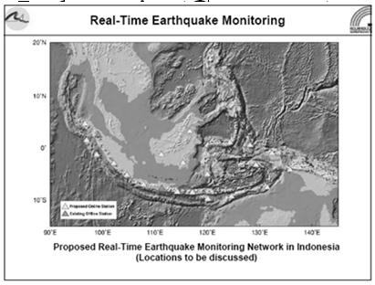
9 Suggested global distribution of deep sea pressure sensors Suggested improvement of seismographic network in Indonesia (Germany) Atlantic Ocean Basin Pacific Ocean Topographic Profile 9


10 Atolls and Guyots Black Smokers: Ocean Floor Hotsprings Mid-Atlantic Ridge, Iceland Ocean Basins and Plates Ocean Terms Tide Wave Height Length Period Base Refraction Tsunami Beach Sea stack Sea Arch Bay-mouth Bar Spit Tombolo Coast Emergent Submergent Atoll Guyot 10
Chapter 17. Ocean and Coastal Processes
 Chapter 17 Ocean and Coastal Processes Ocean Basins and Plates Ocean Basins Ocean Basins are profoundly different from the continents. Ocean crust is thin and dense and young. New ocean crust is generated
The Marine Environment
 The Marine Environment SECTION 16.1 Shoreline Features In your textbook, read about erosional landforms, beaches, estuaries, longshore currents, and rip currents. For each statement below, write or. 1.
Unit 1: Water Systems on Earth Chapter 2
 Unit 1: Water Systems on Earth Chapter 2 Create a mind map with the driving question, Why are Oceans Important? Remember: Why are oceans so important? Why are oceans so important? Primary water source
The Marine Environment
 The Marine Environment SECTION 16.1 Shoreline Features In your textbook, read about erosional landforms, beaches, estuaries, longshore currents, and rip currents. For each statement below, write true or
In 1990, 50% of the U.S. population lived within 75 km of a coast. By 2010, 75% of the U.S. population will live within 75 km of a coast.
 In 1990, 50% of the U.S. population lived within 75 km of a coast. By 2010, 75% of the U.S. population will live within 75 km of a coast. High Tech Methods for Surveying the Deep Sea Floor Fig. 20.18 1
Science 8 - Water Systems Test - Chapters 1-2
 Science 8 - Water Systems Test - Chapters 1-2 Multiple Choice (30 marks) Identify the choice that best completes the statement or answers the question. 1. What percentage represents the amount of fresh
UNIT 1: WATER SYSTEMS ON EARTH CHAPTER 2: OCEANS CONTROL THE WATER CYCLE
 UNIT 1: WATER SYSTEMS ON EARTH CHAPTER 2: OCEANS CONTROL THE WATER CYCLE ORIGINS OF OCEAN WATER OCEANS HAVE FILLED OVER HUNDREDS OF MILLIONS OF YEARS SCIENTISTS BELIEVE THE OCEANS ARE MORE THAN 3 BILLION
Geol 117 Lecture 18 Beaches & Coastlines. I. Types of Coastlines A. Definition:
 I. Types of Coastlines A. Definition: 1. Shore = narrow zone where ocean meets land (e.g. beach) 2. Coast is a broad area where both ocean and land processes act a. Includes onshore marshes, dunes, sea
Section 2.1 Ocean Basins. - Has helped determine where ocean basins are located. - Tectonic plates move changing the position of the continents.
 Science 8 Unit 1: Water Systems on Earth Chapter 2: Oceans Control the Water Cycle Section 2.1 Ocean Basins Oceans are important because: 1. Primary water source for the water cycle 2. Control weather
Oceanography. Oceanography is the study of the deep sea and shallow coastal oceans.
 Oceanography Oceanography is the study of the deep sea and shallow coastal oceans. Studying the Ocean Floor To determine the shape and composition of the ocean floor, scientists use techniques such as
The Coast: Beaches and Shoreline Processes
 1 2 3 4 5 6 7 8 9 The Coast: es and Shoreline Processes Trujillo & Thurman, Chapter 10 Oceanography 101 Chapter Objectives Recognize the various landforms characteristic of beaches and coastal regions.
The Coast: Beaches and Shoreline Processes Trujillo & Thurman, Chapter 10
 The Coast: es and Shoreline Processes Trujillo & Thurman, Chapter 10 Oceanography 101 Chapter Objectives Recognize the various landforms characteristic of beaches and coastal regions. Identify seasonal
Grade 8 Science. Unit 1: Water Systems on Earth Chapter 2
 Grade 8 Science Unit 1: Water Systems on Earth Chapter 2 Oceans are important... 1. Primary water source for the water cycle 2. Control weather 3. Support diverse life 4. Provides humans with food, minerals,
The surface of the ocean floor is as varied as the land. The five major oceans, from largest to smallest, are
 11.1 Ocean Basins The surface of the ocean floor is as varied as the land. The five major oceans, from largest to smallest, are w the Pacific w the Atlantic w the Indian w the Southern w the Arctic The
1 Shoreline Landforms 2. 2 Emergent v. Submergent 2. 3 Wavecutting 3. 4 Planview 4. 5 Marine Terraces 5. 6 California 7. 7 Tombolos, Sea Stacks 8
 Shorelines November 9, 2008 Contents 1 Shoreline Landforms 2 2 Emergent v. Submergent 2 3 Wavecutting 3 4 Planview 4 5 Marine Terraces 5 6 California 7 7 Tombolos, Sea Stacks 8 8 Active Processes 9 9 Emergence
Objectives. Vocabulary
 Shoreline Features Objectives Explain how shoreline features are formed and modified by marine processes. Describe the major erosional and depositional shoreline features. Vocabulary wave refraction beach
Unit 8 Test Review -- Oceanography
 Unit 8 Test Review -- Oceanography Multiple Choice Identify the choice that best completes the statement or answers the question. D 1. A large body of saline water that may be surrounded by land is a(n)
Marine Science and Oceanography
 Marine Science and Oceanography Marine geology- study of the ocean floor Physical oceanography- study of waves, currents, and tides Marine biology study of nature and distribution of marine organisms Chemical
Question: What is the primary reason for the great abundance of fish along the Peruvian coast?
 Buzzer Question # 1 Question Type: toss-up Question Format: Multiple Choice Category: Biology What is the primary reason for the great abundance of fish along the Peruvian coast? Answer W: upwelling Answer
Earth Science Lesson Plan Quarter 2, Week 10, Day 1
 Earth Science Lesson Plan Quarter 2, Week 10, Day 1 Outcomes for Today Standard Focus: PREPARE 1. Background knowledge necessary for today s reading. Beaches are created by the actions of waves, tides,
Supplemental Slides. Shore: Junction of Land & Water. Junction of Land & Water. Sea Level Variations. Shore vs. Coast. Sea Level Variations
 Shore: Junction of Land & Water Supplemental Slides Sediments come off land Most get dumped at the beach Sediment interacts with ocean waves and currents Junction of Land & Water Features: Breaking waves,
Shore: Junction of Land & Water. Sediments come off land Most get dumped at the beach Sediment interacts with ocean waves and currents
 Shore: Junction of Land & Water Supplemental Slides Sediments come off land Most get dumped at the beach Sediment interacts with ocean waves and currents Junction of Land & Water Features: Breaking waves,
Ocean Basins, Bathymetry and Sea Levels
 Ocean Basins, Bathymetry and Sea Levels Chapter 4 Please read chapter 5: sediments for next class and start chapter 6 on seawater for Thursday Basic concepts in Chapter 4 Bathymetry the measurement of
Oceanography II Notes
 Oceanography II Notes Tides The rise and fall in sea level is called a tide. Caused by a giant wave and the gravitational pull of the moon and sun on the ocean One low-tide/high-tide cycle takes about
MULTIPLE CHOICE. Choose the one alternative that best completes the statement or answers the question.
 Geology 300, Physical Geology Spring 2019 Quiz Chapter 18, Seafloor Name MULTIPLE CHOICE. Choose the one alternative that best completes the statement or answers the question. 1) Abyssal fans are made
24. Ocean Basins p
 24. Ocean Basins p. 350-372 Background The majority of the planet is covered by ocean- about %. So the majority of the Earth s crust is. This crust is hidden from view beneath the water so it is not as
The Ocean Floor Earth Science, 13e Chapter 13
 The Ocean Floor Earth Science, 13e Chapter 13 Stanley C. Hatfield Southwestern Illinois College The vast world ocean Earth is often referred to as the blue planet Seventy-one percent of Earth s surface
ARE YOU READY TO THINK? Look at the first slide THINK PAIR SHARE!
 ARE YOU READY TO THINK? Look at the first slide THINK PAIR SHARE! WHAT PROMINENT FEATURE CAN YOU IDENTIFY IN THIS PICTURE? What do you think the different colors represent? Who might find such a picture
MARINE GEOLOGY & GEOGRAPHY
 MARINE GEOLOGY & GEOGRAPHY Bathymetry BATHYMETRY BATHYMETRY THE UNDERWATER EQUIVALENT TO TOPOGRAPHY THE STUDY OF WATER DEPTH A BATHYMETRIC MAP SHOWS FLOOR RELIEF OR TERRAIN AS CONTOUR LINES Bathymetry
OCEANOGRAPHY II NOTES
 TIDES OCEANOGRAPHY II NOTES MRS. BURKEY EARTH SPACE SCIENCE CY CREEK HS THE RISE AND FALL IN SEA LEVEL IS CALLED A TIDE. CAUSED BY A GIANT WAVE. AVERAGE LOW-TIDE/HIGH-TIDE CYCLE TAKES ABOUT 12 HRS AND
Origin of the Oceans II. Earth A Living Planet. Earthquakes and Volcanoes. Plate Tectonics II
 Origin of the Oceans II Plate Tectonics II Earth A Living Planet Heat of formation of the planet is trapped at center, gradually escaping Center is nickel and iron Earthquakes and Volcanoes 1 Tracing the
Topic 5: The Dynamic Crust (workbook p ) Evidence that Earth s crust has shifted and changed in both the past and the present is shown by:
 Evidence that Earth s crust has shifted and changed in both the past and the present is shown by:") Topic 5: The Dynamic Crust (workbook p. 65-85) Evidence that Earth s crust has shifted and changed in both the past and the present is shown by: --sedimentary horizontal rock layers (strata) are found
Topic 5: The Dynamic Crust (workbook p. 65-85) Evidence that Earth s crust has shifted and changed in both the past and the present is shown by: --sedimentary horizontal rock layers (strata) are found
Map shows 3 main features of ocean floor
 Map shows 3 main features of ocean floor 2017 Pearson Education, Inc. Chapter 3 Marine Provinces 2017 Pearson Education, Inc. 1 Chapter 3 Overview The study of bathymetry determines ocean depths and ocean
Chapter 2 Plate Tectonics and the Ocean Floor
 Chapter 2 Plate Tectonics and the Ocean Floor Chapter Overview Much evidence supports plate tectonics theory. The plate tectonics model describes features and processes on Earth. Plate tectonic science
Full file at
 Essentials of Oceanography, 10e (Trujillo/Keller) Chapter 2 Plate Tectonics and the Ocean Floor Match the term with the appropriate phrase. You may use each answer once, more than once or not at all. A)
Bathymetry Measures the vertical distance from the ocean surface to mountains, valleys, plains, and other sea floor features
 1 2 3 4 5 6 7 8 9 10 11 CHAPTER 3 Marine Provinces Chapter Overview The study of bathymetry determines ocean depths and ocean floor topography. Echo sounding and satellites are efficient bathymetric tools.
4. In areas where tectonic plates collide, the seafloor has deep. 5. In areas where tectonic plates separate, the seafloor has mid- ocean
 Name Date Hour Table Chapter 14 Lesson One- General Directions: Use the word bank below to complete each statement. NOT all terms are used. abyssal plains brackish water condensation energy freshwater
Crustal Boundaries. As they move across the asthenosphere and form plate boundaries they interact in various ways. Convergent Transform Divergent
 Name: Date: Period: Plate Tectonics The Physical Setting: Earth Science CLASS NOTES Tectonic plates are constantly moving and interacting As they move across the asthenosphere and form plate boundaries
14. Oceanic crust is neither created nor destroyed along this type of boundary.
 DATE DUE: Name: Instructor: Ms. Terry J. Boroughs Geology 300 PLATE TECTONICS AND the OCEANS Instructions: Read each question carefully before selecting the BEST answer Provide specific and detailed answers
The Ocean Floor Chapter 14. Essentials of Geology, 8e. Stan Hatfield and Ken Pinzke Southwestern Illinois College
 The Ocean Floor Chapter 14 Essentials of Geology, 8e Stan Hatfield and Ken Pinzke Southwestern Illinois College The vast world ocean Earth is often referred to as the water planet 71% of Earth s surface
Introduction to Oceanography. Chapter 2: Plate Tectonics Overview
 Introduction to Oceanography Chapter 2: Plate Tectonics Overview Much evidence supports plate tectonics theory. The plate tectonics model describes features and processes on Earth. Plate tectonic science
Small area of the ocean that is partially surrounded by land. The Ocean Basins. Three Major Oceans. Three Major Oceans. What is a SEA?
 The Ocean Basins How Deep is the Ocean? 1 2 Three Major Oceans Three Major Oceans Pacific Atlantic the shallowest ocean (3.3km average depth) Indian second shallowest ocean (3.8km average depth) Pacific
Instructor: Ms. Terry J. Boroughs Geology 305 PLATE TECTONICS AND the OCEANS Instructions: Read each question carefully before selecting the BEST
 DATE DUE: Name: Instructor: Ms. Terry J. Boroughs Geology 305 PLATE TECTONICS AND the OCEANS Instructions: Read each question carefully before selecting the BEST answer Provide specific and detailed answers
Oceanography is the scientific study of oceans Oceans make up over 70% of the Earth s surface
 Oceanography Oceanography is the scientific study of oceans Oceans make up over 70% of the Earth s surface An ocean must be large and have features which set it apart from other oceans (currents, water
Chapter Overview. Bathymetry. Measuring Bathymetry. Measuring Bathymetry
 CHAPTER 3 Marine Provinces Chapter Overview The study of bathymetry determines ocean depths and ocean floor topography. Echo sounding and satellites are efficient bathymetric tools. Most ocean floor features
Alfred Wegener gave us Continental Drift. Fifty years later...
 CHAPTER 2 Plate Tectonics and the Ocean Floor Plate Tectonics: summary in haiku form Alfred Wegener gave us Continental Drift. Fifty years later... Words Chapter Overview Much evidence supports plate tectonics
Chapter 16. Oceans, Shorelines, and Shoreline Processes
 Chapter 16 Oceans, Shorelines, and Shoreline Processes Introduction Oceans and seas cover 71% of the Earth's surface. Geologic evidence indicates that the Earth has had oceans for at least 3.5 billion
Essentials of Oceanography Eleventh Edition
 Chapter Chapter 1 2 Clickers Lecture Essentials of Oceanography Eleventh Edition Plate Tectonics and the Ocean Floor Alan P. Trujillo Harold V. Thurman Chapter Overview Much evidence supports plate tectonics
SOCIAL STUDIES GENERAL
 GEOGRAPHY, MILITARY Maps War - Greece and Turkey War - Greece and Turkey 1920-1922 (p1) 1920-1922 (p2) Dieppe (p1) Dieppe (p2) Dieppe (p3) Dieppe (p4) Dieppe (p5) 120 GEOGRAPHY, MILITARY Maps Allied advances
4 Tides. What causes tides? How do tides vary?
 CHAPTER 14 4 Tides SECTION The Movement of Ocean Water BEFORE YOU READ After you read this section, you should be able to answer these questions: What causes tides? How do tides vary? National Science
MARINE GEOLOGY & GEOGRAPHY
 MARINE GEOLOGY MARINE GEOLOGY & GEOGRAPHY Marine Geology 4 LAYERS OF THE EARTH CRUST THICKNESS: VARIES BETWEEN OCEAN & CONTINENTS 5-40 KM STATE: SOLID ELEMENTS: SILICON, ALUMINUM, CALCIUM, SODIUM, POTASSIUM
Lab 12 Coastal Geology
 Lab 12 Coastal Geology I. Fluvial Systems Hydrologic Cycle Runoff that flows into rivers = precipitation (rain and snowmelt) [infiltration (loss to groundwater) + evaporation (loss to atmosphere) + transpiration
Earth and Space Science Semester 2 Exam Review. Part 1. - Convection currents circulate in the Asthenosphere located in the Upper Mantle.
 Earth and Space Science 2015 Semester 2 Exam Review Part 1 Convection -A form of heat transfer. - Convection currents circulate in the Asthenosphere located in the Upper Mantle. - Source of heat is from
10/11/2010. Acceleration due to gravity, a. Bulk Properties Mass = 6 x kg Diameter = 12,756 km Density = 5515 kg/m 3 (mix of rock and iron)
") Acceleration due to gravity, a Bulk Properties Mass = 6 x 10 24 kg Diameter = 12,756 km Density = 5515 kg/m 3 (mix of rock and iron) Escape Velocity, v e Albedo Amount of sunlight reflected back into space
Acceleration due to gravity, a Bulk Properties Mass = 6 x 10 24 kg Diameter = 12,756 km Density = 5515 kg/m 3 (mix of rock and iron) Escape Velocity, v e Albedo Amount of sunlight reflected back into space
What type of land feature is located at Point A? A Cliff B Delta C Mountain D Valley
 1 What type of land feature is located at Point A? A Cliff B Delta C Mountain D Valley Alfred Wegener s theory of continental drift was 2 not accepted by scientists when the theory was first proposed.
Earth s Seafloors. Ocean Basins and Continental Margins. Introductory Oceanography Ray Rector - Instructor
 Earth s Seafloors Ocean Basins and Continental Margins Introductory Oceanography Ray Rector - Instructor OCEAN BASINS and CONTINENTAL PLATFORMS Key Concepts I. Earth s rocky surface covered by of two types
5. Convergent boundaries produce a relatively low number of earthquakes compared to other boundaries. a. True
 1. Earth s crust is thinner than its mantle. ANSWER: True 2. The concept of isostacy states that high-density rock will stand higher than low-density rock, which explains the formation of subduction zones.
Chapter 2 Plate Tectonics and the Ocean Floor
 Chapter 2 Plate Tectonics and the Ocean Floor Matching. Match the term or person with the appropriate phrase. You may use each answer once, more than once or not at all. 1. hydrothermal vents A. convergent
I. Earth s Layers a. Crust: Earth s outside layer. Made of mostly rock. i. Continental: er; made of mostly granite, forms the continents and shallow
 I. Earth s Layers a. Crust: Earth s outside layer. Made of mostly rock. i. Continental: er; made of mostly granite, forms the continents and shallow sea beds, floats! ii. Oceanic: er; dense rock such as
1 Shoreline Erosion and Deposition
 CHAPTER 12 1 Shoreline Erosion and Deposition SECTION Agents of Erosion and Deposition BEFORE YOU READ After you read this section, you should be able to answer these questions: What is a shoreline? How
1. Oceans. Example 2. oxygen.
 1. Oceans a) Basic facts: There are five oceans on earth, making up about 72% of the planet s surface and holding 97% of the hydrosphere. Oceans supply the planet with most of its oxygen, play a vital
Earth s Continents and Seafloors. GEOL100 Physical Geology Ray Rector - Instructor
 Earth s Continents and Seafloors GEOL100 Physical Geology Ray Rector - Instructor OCEAN BASINS and CONTINENTAL PLATFORMS Key Concepts I. Earth s rocky surface covered by of two types of crust Dense, thin,
Oceanography, An Invitation to Marine Science 9e Tom Garrison. Ocean Basins Cengage Learning. All Rights Reserved.
 Oceanography, An Invitation to Marine Science 9e Tom Garrison 4 Ocean Basins Key Concepts Tectonic forces shape the seabed The ocean floor is divided into continental margins and deep ocean basins The
4. The map below shows a meandering stream. Points A, B, C, and D represent locations along the stream bottom.
 1. Sediment is deposited as a river enters a lake because the A) velocity of the river decreases B) force of gravity decreases C) volume of water increases D) slope of the river increases 2. Which diagram
UNIT 3 GEOLOGY VOCABULARY FLASHCARDS THESE KEY VOCABULARY WORDS AND PHRASES APPEAR ON THE UNIT 3 CBA
 UNIT 3 GEOLOGY VOCABULARY FLASHCARDS THESE KEY VOCABULARY WORDS AND PHRASES APPEAR ON THE UNIT 3 CBA A map that shows Earth s Topographic Map surface topography, which is Earth s shape and features Contour
TAKE HOME EXAM 8R - Geology
 Name Period Date TAKE HOME EXAM 8R - Geology PART 1 - Multiple Choice 1. A volcanic cone made up of alternating layers of lava and rock particles is a cone. a. cinder b. lava c. shield d. composite 2.
Chapter Overview. Evidence for Continental Drift. Plate Tectonics. Evidence for Continental Drift. Evidence for Continental Drift 9/28/2010
 Chapter Overview CHAPTER 2 Plate Tectonics and the Ocean Floor Much evidence supports plate tectonics theory. Different plate boundaries have different features. Tectonic plates continue to move today.
Oceanography Quiz 2. Multiple Choice Identify the choice that best completes the statement or answers the question.
 Oceanography Quiz 2 Multiple Choice Identify the choice that best completes the statement or answers the question. 1. The highest and lowest tides are known as the spring tides. When do these occur? a.
SHORELINE AND BEACH PROCESSES: PART 2. Implications for Coastal Engineering
 SHORELINE AND BEACH PROCESSES: PART 2 Implications for Coastal Engineering Objectives of the lecture: Part 2 Show examples of coastal engineering Discuss the practical difficulties of ocean engineering
Ch. 9 Review. Pgs #1-31 Write Questions and Answers
 Ch. 9 Review Pgs. 356-357 #1-31 Write Questions and Answers 356-357 #1-5 Answers 1. The layer of the upper mantle that can flow is the: A - Asthenosphere 2. Most scientists rejected Wegener s theory of
L.O: SLOWING STREAMS DEPOSIT (SORT) SEDIMENT HORIZONTALLY BY SIZE.
 SEDIMENT HORIZONTALLY BY SIZE.") L.O: SLOWING STREAMS DEPOSIT (SORT) SEDIMENT HORIZONTALLY BY SIZE. 1. Base your answer to the following question on the profile shown below, which shows the pattern of horizontal sorting produced at a
L.O: SLOWING STREAMS DEPOSIT (SORT) SEDIMENT HORIZONTALLY BY SIZE. 1. Base your answer to the following question on the profile shown below, which shows the pattern of horizontal sorting produced at a
Foundations of Earth Science, 6e Lutgens, Tarbuck, & Tasa
 Foundations of Earth Science, 6e Lutgens, Tarbuck, & Tasa Oceans: The Last Frontier Foundations, 6e - Chapter 9 Stan Hatfield Southwestern Illinois College The vast world ocean Earth is often referred
Moho (Mohorovicic discontinuity) - boundary between crust and mantle
 - boundary between crust and mantle") Earth Layers Dynamic Crust Unit Notes Continental crust is thicker than oceanic crust Continental Crust Thicker Less Dense Made of Granite Oceanic Crust Thinner More Dense Made of Basalt Moho (Mohorovicic
Earth Layers Dynamic Crust Unit Notes Continental crust is thicker than oceanic crust Continental Crust Thicker Less Dense Made of Granite Oceanic Crust Thinner More Dense Made of Basalt Moho (Mohorovicic
Chapter 5 Notes: Plate Tectonics
 Chapter 5 Notes: Plate Tectonics Earth s Interior Scientists learn about the interior of Earth in 2 ways o Direct Method Rock Samples Drilling Caves o Indirect Method Seismic Waves Speed of waves and paths
Practice Questions: Plate Tectonics
 Practice Questions: Plate Tectonics 1. Base your answer to the following question on The block diagram below shows the boundary between two tectonic plates. Which type of plate boundary is shown? A) divergent
Lecture Outlines PowerPoint. Chapter 13 Earth Science 11e Tarbuck/Lutgens
 Lecture Outlines PowerPoint Chapter 13 Earth Science 11e Tarbuck/Lutgens 2006 Pearson Prentice Hall This work is protected by United States copyright laws and is provided solely for the use of instructors
Chapter 18: The Oceans And Their Margins. Introduction: The World s Oceans. The Oceans Characteristics
 Chapter 18: The Oceans And Their Margins Introduction: The World s Oceans Seawater covers 70.8 percent of Earth s surface, in three huge interconnected basins: The Pacific Ocean. The Atlantic Ocean. The
The Sea Floor. Chapter 2
 The Sea Floor Chapter 2 Geography of the Ocean Basins World ocean is the predominant feature on the Earth in total area Northern Hemisphere = 61% of the total area is ocean. Southern Hemisphere = about
The Dynamic Crust 2) 4) Which diagram represents the most probable result of these forces? 1)
 4) Which diagram represents the most probable result of these forces? 1)") 1. The diagrams below show cross sections of exposed bedrock. Which cross section shows the least evidence of crustal movement? 1) 3) 4. The diagram below represents a section of the Earth's bedrock. The
1. The diagrams below show cross sections of exposed bedrock. Which cross section shows the least evidence of crustal movement? 1) 3) 4. The diagram below represents a section of the Earth's bedrock. The
Chapter 02 The Sea Floor
 Chapter 02 The Sea Floor Multiple Choice Questions 1. One of the following is not one of the world's major ocean basins: A. Atlantic Ocean B. Arctic Ocean C. Indian Ocean D. Antarctic Ocean E. Pacific
Plate Tectonics. Chapter 5
 Plate Tectonics Chapter 5 Earth s Interior Scientists learn about the interior of Earth in 2 ways Direct Method Rock Samples Drilling Caves Earth s Interior Indirect Method Seismic Waves Speed of waves
SIO15 Midterm 1, Monday Oct. 30, 2017 TEST VARIATION: 2
 SIO15 Midterm 1, Monday Oct. 30, 2017 TEST VARIATION: 2 1) Over the last 20 years, which of these natural disasters killed the most people in the U.S.? a) heat waves b) hurricanes c) lightning strikes
Test on Chapters 7-11 Monday, April 28, 2014 No Calculator Required
 Test on Chapters 7-11 Monday, April 28, 2014 No Calculator Required Chapter Sections: Oceans: 7.1 7.2 7.4 Bathymetry: 8.3 Earth s Interior: 10.1 10.2 10.3 Plate Tectonics: 11.1 11.2 11.3 Study/Review:
CHAPTER 2 Plate Tectonics and the Ocean Floor Pearson Education, Inc.
 CHAPTER 2 Plate Tectonics and the Ocean Floor Plate Tectonics Alfred Wegener first proposed in 1912 Called it Continental Drift Evidence for Continental Drift 1. Noted puzzle-like fit of modern continents
Science 8 Chapter 2 Section 1
 Science 8 Chapter 2 Section 1 Ocean Basins (pp. 38-51) The World s Oceans The five major oceans, in order from largest to smallest, are the Pacific, Atlantic, Indian, Southern, and Arctic The Southern
Which lettered location has the highest elevation? A) A B) B C) C D) D
 A B) B C) C D) D") 1. New York State's highest peak, Mt. Marcy, is located at approximately A) 44 10' N 74 05' W B) 44 05' N 73 55' W C) 73 55' N 44 10' W D) 74 05' N 44 05' W 2. Four locations, A, B, C, and D, are represented
1. New York State's highest peak, Mt. Marcy, is located at approximately A) 44 10' N 74 05' W B) 44 05' N 73 55' W C) 73 55' N 44 10' W D) 74 05' N 44 05' W 2. Four locations, A, B, C, and D, are represented
Earthquakes. Earthquakes are caused by a sudden release of energy
 Earthquakes Earthquakes are caused by a sudden release of energy The amount of energy released determines the magnitude of the earthquake Seismic waves carry the energy away from its origin Fig. 18.1 Origin
Plate Tectonics Tutoiral. Questions. Teacher: Mrs. Zimmerman. Plate Tectonics and Mountains Practice Test
 Teacher: Mrs. Zimmerman Print Close Plate Tectonics and Mountains Practice Test Plate Tectonics Tutoiral URL: http://www.hartrao.ac.za/geodesy/tectonics.html Questions 1. Fossils of organisms that lived
Ocean Floor. Continental Margins. Divided into 3 major regions. Continental Margins. Ocean Basins. Mid-Ocean Ridges. Include:
 Ocean Floor Divided into 3 major regions Continental Margins Ocean Basins Mid-Ocean Ridges Continental Margins Include: Continental Shelves Continental Slopes Continental Rise 1 Continental Shelves Part
OCN 201 Mantle plumes and hot spots
 OCN 201 Mantle plumes and hot spots Question Long-term (>50 million years) changes in sea level are caused by: A. Changes in the volume of water in the ocean B. Changes in the volume of the ocean basins
LAB 6: TRINIDAD BEACH FIELD TRIP
 OBJECTIVES: LAB 6: TRINIDAD BEACH FIELD TRIP 1) to develop your powers of observation, especially of geological phenomena; 2) to identify the rocks exposed at Trinidad Beach; 3) to reconstruct some of
Ocean facts continued
 Ocean Facts A dynamic system in which many chemical and physical changes take place Formed over millions of years as precipitation filled low areas on Earth called basins and now covers 70% of the Earth
2. A rock cycle diagram is shown below. Which rock layer most likely contains fossils of the most recently evolved organisms?
 Do Not Write On Test - You Will Fail 1. The picture below shows a model of the rock cycle. 3. Shale is a sedimentary rock that can be metamorphosed into slate by A. cementation. B. chemical weathering.
GEOLOGY MEDIA SUITE Chapter 5
 UNDERSTANDING EARTH, SIXTH EDITION GROTZINGER JORDAN GEOLOGY MEDIA SUITE Chapter 5 Sedimentation Rocks Formed by Surface Processes 2010 W.H. Freeman and Company Mineralogy of sandstones Key Figure 5.12
PSc 201 Chapter 3 Homework. Critical Thinking Questions
 PSc 201 Chapter 3 Homework Critical Thinking Questions 1. (adapted from text) Seawater is denser than fresh water. A ship moving from the Atlantic Ocean into the Great Lakes goes from seawater to fresh
Page 1. Name:
 Name: 1) Which event is the best example of erosion? dissolving of rock particles on a limestone gravestone by acid rain breaking apart of shale as a result of water freezing in a crack rolling of a pebble
GLY Coastal Geomorphology Notes
 GLY 4734 - Coastal Geomorphology Notes Dr. Peter N. Adams Spring 2011 2 Coastal Classification In this lecture, we discuss some successful classification schemes of the coastal landscape, and pay particular
The Earth. Part II: Solar System. The Earth. 1a. Interior. A. Interior of Earth. A. The Interior. B. The Surface. C. Atmosphere
 Part II: Solar System The Earth The Earth A. The Interior B. The Surface C. Atmosphere 2 Updated: July 14, 2007 A. Interior of Earth 1. Differentiated Structure 2. Seismography 3. Composition of layers
Grade 7 Science Unit 4: The Earth s Crust PLATE TECTONIC THEORY
 Grade 7 Science Unit 4: The Earth s Crust PLATE TECTONIC THEORY Alfred Wegener 1880 1930 German meteorologist He noticed that the continents fit together like a puzzle. He said that at one time all continents
14.2 Ocean Floor Features Mapping the Ocean Floor
 14.2 Ocean Floor Features Mapping the Ocean Floor The ocean floor regions are the continental margins, the ocean basin floor, and the mid-ocean ridge. 14.2 Ocean Floor Features Continental Margins A continental