A new era of geodetic big data - challenges and opportunities Tim Wright (COMET, University of
|
|
|
- Monica Porter
- 6 years ago
- Views:
Transcription


1 A new era of geodetic big data - challenges and opportunities Tim Wright (COMET, University of Leeds) N
2 A New Era of Geodetic Big Data?


![2 (2004)] Data from](/docs-images/75/71578585/images/3-2.jpg "University of Reno: GSRM,")
3 GEM Strain Rate Model 17,491 GNSS sites included in v2 of GEM Strain Rate Model (2013); [cf. 4,281 in v1.2 (2004)] Data from University of Reno: GSRM, Corné Kreemer
4 Radar Missions RISAT COSMO-4 COSMO-3 COSMO-2 COSMO-1 DesDYNI TerraSAR-L RCM ALOS-2 Sentinel-1B Sentinel-1A JERS-1 Radarsat-1 ERS-2 ERS-1 Envisat ALOS-1 TanDEM-X TerraSAR-X Radarsat

5 Radar Missions RISAT COSMO-4 COSMO-3 COSMO-2 COSMO-1 DesDYNI TerraSAR-L RCM ALOS-2 Sentinel-1B Sentinel-1A JERS-1 Radarsat-1 ERS-2 ERS-1 Envisat ALOS-1 TanDEM-X TerraSAR-X Radarsat

6 Sentinel-1 Constellation Envisat Stand-alone mission not specifically designed for InSAR Haphazard acquisition strategy (multiple modes) Archive typically has ~30 images over 7 years Loss of signal due to long time gaps or large orbital separations Sentinel-1 20 year operational program, designed for InSAR Systematic acquisitions over deformation belts 12 day revisit 30 images per satellite per year 6 day revisit (with two satellites), small orbital separation

")

7 10 km km Digital Topography (LiDAR) SRTM 90 m SPOT5 6 m LiDAR <1 m
8 Challenges
9 Challenges Data Access / Cost GNSS data available for free via UNAVCO (and eventually EPOS) Sentinel-1 data available for free from EU Copernicus, but data from other missions can be very expensive Data volumes Sentinel-1A 0.5 TB/day. LiDAR DEM for 600 km 2 of Afar same size as SRTM for USA+Russia Processing Processing requires specialist knowledge Global GNSS processing available from University of Reno Global InSAR processing will be available from COMET/LiCS Data Information
10 Opportunities

11 Tectonic Strain & Seismic Hazard Figure from Corné Kreemer/Ross Stein/GEM
 77% of fatalities occur where deformation rates are 5 mm/yr over 100")
12 Accuracy Requirements and Earthquake Hazard Cumulative percentage of earthquake deaths Magnitude of tectonic strain (x10-9 /yr) 96% of all earthquake deaths are in regions with strain rates greater than 1mm/yr over 100 km (10-8 /yr) 77% of fatalities occur where deformation rates are 5 mm/yr over 100 km.

13 Achieving 1 mm/yr accuracy Accurate Orbital Models mm/yr 5 0 Atmospheric Corrections -5 Wang, Wright et al, 2008
14 Achieving 1 mm/yr accuracy Length scale of observation (km) mm/yr rates over 100 km can be achieved with 5 years of acquisitions (12 day revisit) Duration of time series (years) mm/yr Wang, Wright et al, 2008


15 Example: Strain mapping in E. Turkey Turkey Iran

16 Mapping tectonic strain with InSAR E = e xy 2 e xx e yy Walters et al. (JGR In revision 2014) Methods: Wang and Wright (GRL 2012)

17 How much better than existing missions? Envisat Data, 70 Day Repeat, 7 years data 40% of areas straining above 10-8 yr -1 Sentinel-1A Data, 12 Day Repeat, 5 years data 80% of areas straining above 10-8 yr -1 [90 % with two satellites] Wright et al., Fringe 2011

18 Yamasaki, Wright and Houseman (JGR 2014) Modelling time-varying phenomena Weak τ 0 = 0.01 Strong τ 0 = 1 Geodesist s view of a fault zone

19 Modelling time-varying phenomena Post-intrusion deformation in Afar requires magma movement plus viscoelastic deformation. Hamling et al. (GJI 2014)


20 How do faults link and grow? Vertical movement in Afar between October 2009 and November Barbara Hofmann PhD thesis (2014)


21 Earthquake Early Warning with GPS Wright et al., GRL 2012


22 Monitoring volcanic crises (e.g. Santorini) Parks et al., Nature Geoscience 2012
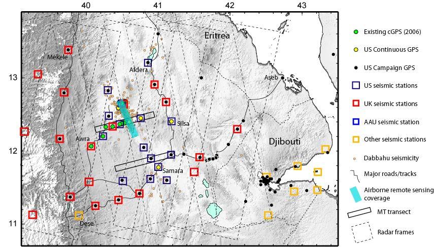


23 Integrating different disciplines e.g. The Afar Rift Consortium Dabbahu segment Hararo segment

24 Data Precise Orbits for Sentinel-1 Water Vapour measurements LiCS: Looking inside the continents from space (NERC Large grant ) High-resolution deformation measurements from Sentinel-1 Fault Map for Alpine- Himalayan Belt Derived products Earthquake source models Regional Strain Maps Models Earthquake Cycle Deformation Models 3D Models of Continental Tectonics Information Earthquake Hazard


25 Sub-Commission 3.5: Tectonics and Earthquake Geodesy WEGENER 2014 (1-4 September 2014, Leeds, UK): Measuring and Modelling our Dynamic Planet 17 th General Assembly of WEGENER on earth deformation and the study of earthquakes using geodesy and geodynamics

26 Geographical coverage Global Tectonics: 55 Mkm 2 Ice: 5 Mkm 2 Europe: 10 Mkm 2 Total: 70 Mkm 2 Data throughput = 0.5 TB/day [~1PetaByte over 5 years]
27 Processing strategy Continuous, near-global processing T=0 ~1 yr (?) +12 days +24 days +36 days Orbit Models (real time + precise) Atmospheric Models (real time + reanalysis) Initial time series Initial linear rates Updated time series Updated linear rates
28 Data throughput schematic CEMS-academic CEMS-catapult COMET workspace COMET processing facility 10Gb/s link S1-cache Catapult processing facility Catapult Archive BT link S1-PAC COMET archive Catapult services Farnborough Processed results from CEMSacademic will be available free of charge for all users Science users Non-academic users
 arctan (x/d) NAF EAF s")

29 Savage and Burford, 1973 y = (s/π) arctan (x/d) NAF EAF s = mm/yr d = km s = mm/yr d = km


30 Velocity field method VELMAP: Wang and Wright, 2012
Towards Routine Monitoring of Tectonic and Volcanic Deformation with Sentinel-1
 INSARAP Towards Routine Monitoring of Tectonic and Volcanic Deformation with Sentinel-1 Wright, Tim J (1); Biggs, Juliet (2); Crippa, Paula (3); Ebmeier, Susanna K. (2); Elliott, John (4); Gonzalez, Pablo
Infrastructure monitoring using SAR interferometry
 Infrastructure monitoring using SAR interferometry Hossein Nahavandchi Roghayeh Shamshiri Norwegian University of Science and Technology (NTNU), Department of Civil and Environmental Engineering Geodesy
The Santorini Inflation Episode, Monitored by InSAR and GPS
 The Santorini Inflation Episode, Monitored by InSAR and GPS Ioannis Papoutsis 1,2, Xanthos Papanikolaou 2, Michael Floyd 3, Kang Hyeun Ji 4, Charalampos Kontoes 1, Demitris Paradissis 2, Demitris Anastasiou
Committee on Earth Observation Satellites. The CEOS Volcano Demonstrator Rationale and Implementation
 Committee on Earth Observation Satellites The CEOS Volcano Demonstrator Rationale and Implementation Why focus on volcanoes? Over 300,000 people have been killed by volcanoes since the 1600s Globally,
GEO-VIII November Geohazard Supersites and Natural Laboratories Progress Report. Document 9
 GEO-VIII 16-17 November 2011 Geohazard Supersites and Natural Laboratories Progress Report Document 9 This document is submitted to GEO-VIII for information. Geohazard Supersites and Natural Laboratories
The PaTrop Experiment
 Improved estimation of the tropospheric delay component in GNSS and InSAR measurements in the Western Corinth Gulf (Greece), by the use of a highresolution meteorological model: The PaTrop Experiment N.
The Geohazard Supersites and Natural Laboratories (GSNL).
.") The Geohazard Supersites and Natural Laboratories (GSNL). Falk Amelung, University of Miami Mike Poland, Hawaii Volcano Observatory Scott Baker, U of Miami, Unavco Outline: Overview over GSNL (Phase 2)
The Geohazard Supersites and Natural Laboratories (GSNL). Falk Amelung, University of Miami Mike Poland, Hawaii Volcano Observatory Scott Baker, U of Miami, Unavco Outline: Overview over GSNL (Phase 2)
The Afar Rift Consortium
 The Afar Rift Consortium University of Bristol University of Oxford University of Cambridge British Geological Survey University of Rochester University of Auckland, NZ Opportunistic programme following
Volcanoes Session. Chairs: Y. Fukushima & G. Puglisi
 Volcanoes Session Chairs: Y. Fukushima & G. Puglisi Presentation Summary We had presentations on volcanoes all over the world, more than the last FRINGE workshops: Etna, Campi Flegrei, Ethiopian rift,
Geodetic Observing Systems: tools in observing the Glacial Isostatic Adjustment. Markku Poutanen Finnish Geodetic Institute
 Geodetic Observing Systems: tools in observing the Glacial Isostatic Adjustment Markku Poutanen Finnish Geodetic Institute Glacial Isostatic Adjustment Land uplift is just one consequence of the physical
EXPLORE PLATE TECTONICS & MORE THROUGH GPS DATA. Shelley Olds, UNAVCO April 12, 2018 NGSS Webinar
 EXPLORE PLATE TECTONICS & MORE THROUGH GPS DATA Shelley Olds, UNAVCO April 12, 2018 NGSS Webinar Today s Outline Central question: How do we know the tectonic plates are still moving? -- What evidence
Paul A. Rosen Jet Propulsion Laboratory, California Institute of Technology. UNAVCO Workshop Boulder, Colorado March 10, 2010
 GSHAP L. Wood, P. Worfolk et al., SaVi - Satellite constellation Visualisation software, http://savi.sf.net/, 2010. Paul A. Rosen Jet Propulsion Laboratory, California Institute of Technology UNAVCO Workshop
Comparison of 17 Strain-Rate Models from GPS Geodesy
 Comparison of 17 Strain-Rate Models from GPS Geodesy overview of 17 strain rate models fits to dense GPS and 12 models too smooth cross correlation among models and seismicity rate strain-rate tensor maps
The Global Geodetic Observing System (GGOS) of the International Association of Geodesy, IAG
 of the International Association of Geodesy, IAG") The Global Geodetic Observing System (GGOS) of the International Association of Geodesy, IAG Hans-Peter Plag (1), Markus Rothacher (2), Richard Gross (3), Srinivas Bettadpur (4) (1) Nevada Bureau of Mines
The Global Geodetic Observing System (GGOS) of the International Association of Geodesy, IAG Hans-Peter Plag (1), Markus Rothacher (2), Richard Gross (3), Srinivas Bettadpur (4) (1) Nevada Bureau of Mines
Geohazard Supersites and Natural Laboratories
 Geohazard Supersites and Natural Laboratories FRINGE 2011, Frascati, Italy, September 19, 2011 Wolfgang Lengert, ESA Falk Amelung, University of Miami, GEO task lead Craig Dobson, NASA, CEOS task lead
ECVs: What s operational and what still requires R&D?
 Glaciers_cci input on ECVs: What s operational and what still requires R&D? Frank Paul* Department of Geography, University of Zurich *on behalf of the Glaciers_cci consortium Google Earth Operational
Q1-Q CEOS Seismic Pilot report. CEOS Thematic Pilots
 CEOS Thematic Pilots Q1-Q2 2016 CEOS Seismic Pilot report Seismic Pilot/ Objective A, B and C March 2016- PI or PoC: Philippe Bally August 2016 (ESA) and Stefano Salvi (INGV). Collaborating organisations:
Lab 9: Satellite Geodesy (35 points)
") Lab 9: Satellite Geodesy (35 points) Here you will work with GPS Time Series data to explore plate motion and deformation in California. This lab modifies an exercise found here: http://www.unavco.org:8080/cws/pbonucleus/draftresources/sanandreas/
Lab 9: Satellite Geodesy (35 points) Here you will work with GPS Time Series data to explore plate motion and deformation in California. This lab modifies an exercise found here: http://www.unavco.org:8080/cws/pbonucleus/draftresources/sanandreas/
GEODETIC NETWORK OF SAUDI ARABIA AND FIDUCIAL STATIONS. GFN OF Saudi Arabia in Based on ITRF2000 Datum
 STUDIES OF TECTONIC MOVEMENTS IN SAUDI ARABIA USING CORS M. Al Rajhi, Ali Al Omar, R. Yanar, F. Kartal, K. Eren, SUBJECT TO TALKS BACKGROUND GEODETIC NETWORK OF SAUDI ARABIA AND FIDUCIAL STATIONS GFN OF
Interplay between tectonics and magmatism during the last stages of continental breakup
 R. Pik, P. Burnard, A. Williams, C. Vye, L. France, D. Ayalew, G. Yirgu Interplay between tectonics and magmatism during the last stages of continental breakup The Manda Hararo rift segment, Afar, Ethiopia
Geohazard Supersites and Natural Laboratories
 Geohazard Supersites and Natural Laboratories FRINGE 2011, Frascati, Italy, September 19, 2011 Wolfgang Lengert, ESA Falk Amelung, University of Miami, GEO task lead Craig Dobson, NASA, CEOS task lead
Copernicus Today and Tomorrow GEO Week Group on Earth Observation Geneva, 16 January 2014 The Copernicus Space Infrastructure
 Copernicus Today and Tomorrow GEO Week Group on Earth Observation Geneva, 16 January 2014 The Copernicus Space Infrastructure Thomas Beer, Policy Coordinator, Copernicus Space Office, ESA-ESRIN, Frascati
InSAR results from the WInSAR Consortium
 InSAR results from the WInSAR Consortium Matt Pritchard (1); Eric Fielding (2); Shimon Wdowinski (3); Scott Baker (4); Zhong Lu (5); and 160 WInSAR Institution members (6) 1: Cornell University; 2: Jet
Volcano Monitoring on a Regional Scale:
 Volcano Monitoring on a Regional Scale: Results from the CEOS Disaster Risk Management Volcano Pilot David Arnold 1 Juliet Biggs 1 Francisco Delgado 2 Matt Pritchard 2 Susi Ebmeier 1 Mike Poland 3 Simona
Geological Mapping Using EO Data for Onshore O&G Exploration
 Geological Mapping Using EO Data for Onshore O&G Exploration Michael Hall ESA Oil and Gas Workshop, Frascati, Italy michael.hall@infoterra-global.com Why use EO data for Geological Mapping? Availability
The Polar Ice Sheets Monitoring Project A Coordinated Response from Space Agencies
 The Polar Ice Sheets Monitoring Project A Coordinated Response from Space Agencies Yves Crevier / Members of the PSTG SAR Coordination WG Canadian Space Agency CEOS SIT-28 Meeting Hampton, Virginia, USA
GG S. Internal Vision of GGOS. Markus Rothacher. GFZ Potsdam
 Internal Vision of GGOS Markus Rothacher GFZ Potsdam GGOS Retreat DGFI in Munich February 15-16, 2006 Contents Motivation Four Levels of Products of the IAG Services: First Level: Raw Data Collection Second
Summaries and Recommendations of the Fringe 2007 Workshop
 Summaries and Recommendations of the Fringe 2007 Workshop The Fringe 2007 summaries and recommendations have been prepared by the session chairpersons and are grouped by session. Methodology: General -
Report for 15th PCGIAP Meeting at 18th UNRCC-AP Working Group 1 Regional Geodesy
 Report for 15th PCGIAP Meeting at 18th UNRCC-AP Working Group 1 Regional Geodesy Chairman Shigeru Matsuzaka, Japan - shigeru@gsi.go.jp Vice Chairman Prof. Pengfei Cheng, China - chengpf@casm.ac.cn John
High-resolution temporal imaging of. Howard Zebker
 High-resolution temporal imaging of crustal deformation using InSAR Howard Zebker Stanford University InSAR Prehistory SEASAT Topographic Fringes SEASAT Deformation ERS Earthquake Image Accurate imaging
Two Contrasting InSAR Studies of Recent Earthquakes in Tibet
 Two Contrasting InSAR Studies of Recent Earthquakes in Tibet Barry Parsons Department of Earth Sciences University of Oxford John Elliott, Wanpeng Feng,, James Jackson, Zhenhong Li, Xinjian Shan, Alastair
Sentinel and ESA Third-Party Mission data access and processing tools
 Sentinel and ESA Third-Party Mission data access and processing tools Magdalena Fitrzyk RSAC c/o ESA ESRIN 11/09/2018 Content Copernicus Sentinel missions Copernicus Open Access Hub: Sentinels Data Access
UN COPUOS 52 nd session of the Scientific and Technical Subcommittee. COPERNICUS - an European Achievement. S. Jutz Head, ESA Copernicus Space Office
 UN COPUOS 52 nd session of the Scientific and Technical Subcommittee COPERNICUS - an European Achievement S. Jutz Head, ESA Copernicus Space Office 11 Feb 2015, Vienna 1 2 What is Copernicus? European
Basics of the modelling of the ground deformations produced by an earthquake. EO Summer School 2014 Frascati August 13 Pierre Briole
 Basics of the modelling of the ground deformations produced by an earthquake EO Summer School 2014 Frascati August 13 Pierre Briole Content Earthquakes and faults Examples of SAR interferograms of earthquakes
Gets Boost from a New Satellite
 Earthquake Monitoring Gets Boost from a New Satellite By J. R. Elliott, A. J. Elliott, A. Hooper, Y. Larsen, P. Marinkovic, T. J. Wright Fig. 1. Sentinel-1A interferogram built by comparing scans near
GEORED Project: GNSS Geodesy Network for Geodynamics Research in Colombia, South America. Héctor Mora-Páez
 GEORED Project: GNSS Geodesy Network for Geodynamics Research in Colombia, South America. Héctor Mora-Páez Colombian Geological Survey UNAVCO SCIENCE MEETING Feb 27 March 1, 2012 Boulder, CO, TECTONIC
Estelle Chaussard Berkeley Seismological Laboratory
 Estelle Chaussard Berkeley Seismological Laboratory Data integra1on of data we ALREADY have à con1nua1on + ready for large datasets + use exis1ng data for new purposes (improved processing, resolu1on,...)
Earth Science 14 th Edition, 2015 Tarbuck Lutgens - Tasa
 A Correlation of Tarbuck Lutgens - Tasa To the Oklahoma Academic Standards for Earth & Space Science A Correlation of, EARTH & SPACE SCIENCE HS-ESS1 Earth s Place in the Universe HS-ESS1-1 Students who
NCC roles in successful disaster response I.R.IRAN
 The Second UN-GGIM-AP Plenary Meeting NCC roles in successful disaster response I.R.IRAN Teheran Iran 28-30 October 2013 Ali Javidaneh Technical Deputy of National Cartographic Center (NCC) Outline Types
A Unique Reference Frame: Basis of the Global Geodetic Observing System (GGOS) for Geodynamics and Global Change
 for Geodynamics and Global Change") SRTM (InSAR) A Unique Reference Frame: Basis of the Global Geodetic Observing System (GGOS) for Geodynamics and Global Change Hermann Drewes President IAG Commission 1 Reference Frames Deutsches Geodätisches
SRTM (InSAR) A Unique Reference Frame: Basis of the Global Geodetic Observing System (GGOS) for Geodynamics and Global Change Hermann Drewes President IAG Commission 1 Reference Frames Deutsches Geodätisches
Surface Deformation Measurements Scientific Requirements & Challenges
 Surface Deformation Measurements Scientific Requirements & Challenges 1st Science and Application Workshop for Germany-Japan Next-Generation SAR M. Eineder, C. Minet, A. Parizzi Tokyo, 27.6.2013 Tandem-L
Committee on Earth Observation Satellites. Landslide Disaster Working Group Pilot: Status Report. March 8th, 2016
 Committee on Earth Observation Satellites Landslide Disaster Working Group Pilot: Status Report March 8th, 2016 Motivation Langtang Valley, Nepal View from the ground (Photo credit USGS) Landsat-8 Pre
INSAR ATMOSPHERIC DELAY MIGITIGATION BY GPS; CASE STUDY IZMIT EARTQUAKE INTERFEROGRAMS
 INSAR ATMOSPHERIC DELAY MIGITIGATION BY GPS; CASE STUDY IZMIT EARTQUAKE INTERFEROGRAMS M.U. Altın a, *, E. Tari a, L. Ge b a ITU, Civil Engineering Faculty, 80626 Maslak Istanbul, Turkey (altinm, tari)@itu.edu.tr
The Tohoku Earthquake 2011 Case.
 Wide Area Deformation map generation with TerraSAR-X Data. The Tohoku Earthquake 2011 Case. N. Yague-Martinez (1), C. Minet (2), M. Eineder (2), B. Schättler (2) (1) Starlab, Spain (2) Remote Sensing Technology
Interferometric Synthetic Aperture Radar (InSAR): Its Past, Present and Future
: Its Past, Present and Future") Interferometric Synthetic Aperture Radar (InSAR): Its Past, Present and Future by Zhong Lu, Ohig Kwoun, and Russell Rykhus Introduction Very simply, interferometric synthetic aperture radar (InSAR) involves
Interferometric Synthetic Aperture Radar (InSAR): Its Past, Present and Future by Zhong Lu, Ohig Kwoun, and Russell Rykhus Introduction Very simply, interferometric synthetic aperture radar (InSAR) involves
Geoscience Australia Report on Cal/Val Activities
 Medhavy Thankappan Geoscience Australia Agency Report I Berlin May 6-8, 2015 Outline 1. Calibration / validation at Geoscience Australia Corner reflector infrastructure for SAR calibration (for information)
USING LIDAR MEASUREMENTS FOR IMPROVING OR UP-DATING A DEM
 JAES_1(14)_3_2011 VAIS M. et. all, pp.123-128 SECTION Geodesic Engineering USING LIDAR MEASUREMENTS FOR IMPROVING OR UP-DATING A DEM VAIS Manuel*, IOSIF Gheorghe, Bucharest University, *e-mail: manuel.vais@sipg.ro
Joint inversion of InSAR and broadband teleseismic waveform data with ABIC: application to the 1997 Manyi, Tibet earthquake
 Joint inversion of InSAR and broadband teleseismic waveform data with ABIC: application to the 1997 Manyi, Tibet earthquake Gareth Funning 1, Yukitoshi Fukahata 2, Yuji Yagi 3 & Barry Parsons 4 1 University
Geodetic observations of the ongoing Dabbahu rifting episode: new dyke intrusions in 2006 and 2007
 Geophys. J. Int. (2009) doi: 10.1111/j.1365-246X.2009.04163.x Geodetic observations of the ongoing Dabbahu rifting episode: new dyke intrusions in 2006 and 2007 Ian J. Hamling, 1 Atalay Ayele, 2 Laura
Geodesy (InSAR, GPS, Gravity) and Big Earthquakes
 and Big Earthquakes") Geodesy (InSAR, GPS, Gravity) and Big Earthquakes Mathew Pritchard Teh-Ru A. Song Yuri Fialko Luis Rivera Mark Simons UJNR Earthquake Research Panel, Morioka, Japan - Nov 6, 2002 Goals Accurate and high
Geodesy (InSAR, GPS, Gravity) and Big Earthquakes Mathew Pritchard Teh-Ru A. Song Yuri Fialko Luis Rivera Mark Simons UJNR Earthquake Research Panel, Morioka, Japan - Nov 6, 2002 Goals Accurate and high
Application of satellite InSAR data for hydrocarbon reservoir monitoring
 Application of satellite InSAR data for hydrocarbon reservoir monitoring A. Tamburini, A. Belson, A. Ferretti, F. Novali TRE Milano, Italy Copyright - Tele-Rilevamento Europa - 2004 Outline SqueeSAR TM
Sentinel-1 Mission Status
 Sentinel-1 Mission Status Pierre Potin, Sentinel-1 Mission Manager, ESA Luca Martino, Technical Support Engineer, ESA... and the Sentinel-1 operations team PSTG SAR Coordination Working Group 14 December
Sentinel-1 Mission Status
 Sentinel-1 Mission Status Pierre Potin, Sentinel-1 Mission Manager 5TH GEOGLAM RAPP Workshop 16-17 May 2017, ESRIN Sentinel-1: Copernicus radar imaging mission for ocean, land, emergency Part of the Copernicus
Regional Geodesy. Shimon Wdowinski. MARGINS-RCL Workshop Lithospheric Rupture in the Gulf of California Salton Trough Region. University of Miami
 MARGINS-RCL Workshop Lithospheric Rupture in the Gulf of California Salton Trough Region Regional Geodesy Shimon Wdowinski University of Miami Rowena Lohman, Kim Outerbridge, Tom Rockwell, and Gina Schmalze
EO4SEE - THE PATHFINDER OF OPERATIONAL SATELLITE MONITORING FOR THE REGION OF THE BLACK SEA AND CENTRAL EUROPE
 EO4SEE: Pathfinder assessment for regional high volume data access, processing and information service delivery platforms - South East Region EO4SEE - THE PATHFINDER OF OPERATIONAL SATELLITE MONITORING
to: Interseismic strain accumulation and the earthquake potential on the southern San
 Supplementary material to: Interseismic strain accumulation and the earthquake potential on the southern San Andreas fault system by Yuri Fialko Methods The San Bernardino-Coachella Valley segment of the
Copernicus Opportunities and Challenges in Europe s eyes on Earth
 Copernicus Opportunities and Challenges in Europe s eyes on Earth Gunter Schreier Deputy Director DLR German Remote Sensing Data Center - Earth Observation Center Rotterdam 25. Mai 2016 Sentinel - Missions
The Impact of the 2010 Darfield (Canterbury) Earthquake on the Geodetic Infrastructure in New Zealand 1
 Earthquake on the Geodetic Infrastructure in New Zealand 1") The Impact of the 2010 Darfield (Canterbury) Earthquake on the Geodetic Infrastructure in New Zealand 1 Graeme BLICK, John BEAVAN, Chris CROOK, Nic DONNELLY Keywords: Darfield Earthquake, control, survey,
The Impact of the 2010 Darfield (Canterbury) Earthquake on the Geodetic Infrastructure in New Zealand 1 Graeme BLICK, John BEAVAN, Chris CROOK, Nic DONNELLY Keywords: Darfield Earthquake, control, survey,
GSNL - Geohazard Supersites and Natural Laboratories. Biennial report for Candidate/Permanent Supersite. Hawaiʻi Supersite. Annex to report
 Introduction Biennial report for Candidate/Permanent Supersite Hawaiʻi Supersite Annex to 2014 2016 report During 2014 2016, the Hawaiʻi Supersite achieved a number of noteworthy results. This annex details
What are the social, technical, environmental and economic benefits and opportunities of accessing and sharing geodetic data?
 What are the social, technical, environmental and economic benefits and opportunities of accessing and sharing geodetic data? Graeme Blick Group Manager Positioning and Resilience Land Information New
Ice & Snow Session. Chairs: J. Mouginot & N. Gourmelen
 Ice & Snow Session Chairs: J. Mouginot & N. Gourmelen Session 12 talks and 10 posters Antarctic ice motion, ground-line detection and monitoring, dynamics ice-fluctuations in Antarctica and Greenland,
Multi-interferogram method for measuring interseismic deformation: Denali Fault, Alaska
 Geophys. J. Int. (27) 17, 1165 1179 doi: 1.1111/j.1365-246X.27.3415.x Multi-interferogram method for measuring interseismic deformation: Denali Fault, Alaska Juliet Biggs, 1 Tim Wright, 2 Zhong Lu 3 and
The BEYOND Center of Excellence for monitoring natural disasters from space
 The BEYOND Center of Excellence for monitoring natural disasters from space Ioannis Papoutsis National Observatory of Athens Institute for Astronomy, Astrophysics, Space Applications & Remote Sensing MOWE-IT
VALIDATION OF THE PERMANENT SCATTERERS TECHNIQUE IN URBAN AREAS
 VALIDATION OF THE PERMANENT SCATTERERS TECHNIQUE IN URBAN AREAS Alessandro Ferretti, Claudio Prati, Fabio Rocca, Carlo Colesanti Dipartimento di Elettonica e Informazione Politecnico di Milano Piazza L.
GPS and GIS Assisted Radar Interferometry
 GPS and GIS Assisted Radar Interferometry Linlin Ge, Xiaojing Li, Chris Rizos, and Makoto Omura Abstract Error in radar satellite orbit determination is a common problem in radar interferometry (INSAR).
CEOS Support to the Geohazard Supersites
 The CEOS Supersite Coordination Team: Simona Zoffoli, ASI Steven Hosford, CNES Christine Giguère, CSA Jörn Hoffmann, DLR (Chair) Wolfgang Lengert, ESA Kazuo Umezawa, JAXA Shizu Yabe, JAXA Francis Lindsay,
Yellowstone Hotspot Component of the Plate Boundary Observatory
 Yellowstone Hotspot Component of the Plate Boundary Observatory (Investigators: Smith, Thatcher, Meertens, Humphreys, Dzurisin, Oldow Co-Investigators: Christiansen, Doss, Schwartz, Machette, Wong, Olig,
Interferometric Synthetic Aperture Radar (InSAR) and GGOS. Andrea Donnellan NASA/JPL February 21, 2007
 and GGOS. Andrea Donnellan NASA/JPL February 21, 2007") Interferometric Synthetic Aperture Radar (InSAR) and GGOS Andrea Donnellan NASA/JPL February 21, 2007 Sources for Science Objectives Fourth component of EarthScope Involvement: NSF, NASA, USGS, Universities
Interferometric Synthetic Aperture Radar (InSAR) and GGOS Andrea Donnellan NASA/JPL February 21, 2007 Sources for Science Objectives Fourth component of EarthScope Involvement: NSF, NASA, USGS, Universities
Yrd. Doç. Dr. Saygın ABDİKAN Öğretim Yılı Güz Dönemi
 Yabancı Dil III (YDL285) Introduction to Geomatics Yrd. Doç. Dr. Saygın ABDİKAN 2017-2018 Öğretim Yılı Güz Dönemi 1 géomatique Geo (Earth) + informatics Geodesy + Geoinformatics Geomatics: The mathematics
The Geohazards Lab. CEOS WG Disasters. CEOS Disaster Risk Management. CEOS WG Disasters 10 th meeting
 CEOS Disaster Risk Management CEOS WG Disasters The Geohazards Lab CEOS WG Disasters 10 th meeting Philippe Bally, ESA Theodora Papadopoulou, ARGANS c/ ESA Michael Foumelis, BRGM CEOS WG Disasters Buenos
TS Tectonics & Structural Geology Orals and PICOs Monday, 08 April
 TS Tectonics & Structural Geology Orals and PICOs Monday, 08 April MO1, 08:30 10:00 MO2, 10:30 12:00 MOL, 12:15 13:15 MO3, 13:30 15:00 MO4, 15:30 17:00 GD3.3/GM3.3/GMPV16/TS4.7, The evolution of plate
Opportunities for advanced Remote Sensing; an outsider s perspective
 Opportunities for advanced Remote Sensing; an outsider s perspective Ramon Hanssen Delft University of Technology 1 Starting questions Can we do more with the data we are already acquire? What s in stock
ERS Track 98 SAR Data and InSAR Pairs Used in the Analysis
 ERS Track 98 SAR Data and InSAR Pairs Used in the Analysis Date 1 Date 2 Date 1 Date 2 Date 1 Date 2 Date 1 Date 2 7/17/1992 6/19/2000 7/17/1992 7/2/1993 9/10/1993 10/28/1996 9/3/1995 10/18/1999 9/25/1992
In order to obtain a long term monitoring result for the Kilauea Volcano, ALOS PALSAR images taken on Track 287, Frame 38, ascending orbit with 21.5 d
 ALOS PALSAR OBSERVATION OF KILAUEA VOLCANO ACTIVITIES FROM 2006 TO 2009 Zhe Hu, Linlin Ge, Xiaojing Li, Kui Zhang, Alex Hay-Man NG and Chris Rizos Cooperative Research Centre for Spatial Information &
Evolution of the 2007 earthquake swarm, Tanzania: Envisat and ALOS interferometry, ground observations and elastic modeling
 Evolution of the 2007 earthquake swarm, Tanzania: Envisat and ALOS interferometry, ground observations and elastic modeling Gidon Baer, Yariv Hamiel, Gadi Shamir, Ran Nof Geological Survey of Israel East
Diverse deformation patterns of Aleutian volcanoes from InSAR
 Diverse deformation patterns of Aleutian volcanoes from InSAR Zhong Lu 1, Dan Dzurisin 1, Chuck Wicks 2, and John Power 3 U.S. Geological Survey 1 Cascades Volcano Observatory, Vancouver, Washington 2
sentinel-3 A BIGGER PICTURE FOR COPERNICUS
 sentinel-3 A BIGGER PICTURE FOR COPERNICUS SATELLITES TO SERVE By providing a set of key information services for a wide range of practical applications, Europe s Copernicus programme has been put in place
Dyke-maintained rift segmentation at continental rupture
 Dyke-maintained rift segmentation at continental rupture the 2005 Dabbahu (Afar) rifting episode Tim Wright, C. Ebinger, J. Biggs, A. Ayele, G. Yirgu, D. Keir, and A. Stork Supplementary Information Structure
New satellite mission for improving the Terrestrial Reference Frame: means and impacts
 Fourth Swarm science meeting and geodetic missions workshop ESA, 20-24 March 2017, Banff, Alberta, Canada New satellite mission for improving the Terrestrial Reference Frame: means and impacts Richard
Getting to know EarthScope Plate
 Getting to know EarthScope Plate Boundary Observatory & UNAVCO Shelley Olds, UNAVCO !!"#$%&'$!("($)*&'+'$$!!,&-./,01$!2,&3,/4*5$!6+57+/389.-:,;+/&+'$ About UNAVCO!"#$%$&"&'()*'+(#$',#') -'('"-#.)",/)'/0#"1+,)
SIRGAS: Basis for Geosciences, Geodata, and Navigation in Latin America
 SIRGAS: Basis for Geosciences, Geodata, and Navigation in Latin America Claudio Brunini President of SIRGAS Universidad Nacional de La Plata, Argentina María Virginia Mackern President of SIRGAS/WG-I:
GNSS Observations & Sea Level
 with contributions from: - Marta Marcos - Alvaro Santamaria - GNSS Observations & Sea Level Guy Wöppelmann gwoppelm@univ-lr.fr Outline: 1. Introduction 2. The importance of Vertical Land Motions 3. The
PLATE DEFORMATION - 2
 H4.SMR/1775-24 "8th Workshop on Three-Dimensional Modelling of Seismic Waves Generation, Propagation and their Inversion" 25 September - 7 October 2006 PLATE DEFORMATION - 2 Roberto Sabadini Dipartimento
GEOMATICS AND DISASTER MANAGEMENT: Early Impact assessment in Haiti
 GEOMATICS AND DISASTER MANAGEMENT: Early Impact assessment in Haiti We will talk about... Post-disaster response: the main questions to be answered Post-disaster rapid mapping: the role of Geomatics The
Photo credit: S Dumont
 Satellite Monitoring of the 2014 Dyke Intrusion and Eruption within the Bárðarbunga Volcanic System, facilitated by the CEOS Icelandic SUPERSITE M Parks, S Dumont, V Drouin, F Sigmundsson, K Spaans, A
Slow Deformation of Mt. Baekdu Stratovolcano Observed by Satellite Radar Interferometry
 Slow Deformation of Mt. Baekdu Stratovolcano Observed by Satellite Radar Interferometry Sang-Wan Kim and Joong-Sun Won Department of Earth System Sciences, Yonsei University 134 Shinchon-dong, Seodaemun-gu,
Central Asian Institute for Applied Geosciences: one year with Sentinel Asia
 Central Asian Institute for Applied Geosciences: one year with Sentinel Asia http://www.caiag.kg Dr. B.Moldobekov DPN and JPTM 2010 for Sentinel Asia STEP-2 5-8 July 2010, Manila, Philippines Concept of
GCOS High Resolution Land Cover ECV. Slide 11
 GCOS High Resolution Land Cover ECV Slide 11 Detailed Land Cover and Climate Land cover and its changes modify the goods and services provided to human society force climate by altering water and energy
Journal of Geodynamics
 Journal of Geodynamics 49 (2010) 161 170 Contents lists available at ScienceDirect Journal of Geodynamics journal homepage: http://www.elsevier.com/locate/jog Recent advances on surface ground deformation
Land subsidence induced by groundwater extraction in the Alto Guadalentín aquifer, SE Spain.
 Land subsidence induced by groundwater extraction in the Alto Guadalentín aquifer, SE Spain. Pablo Ezquerro, Marta Béjar-Pizarro, Gerardo Herrera, José A. Fernández Merodo, Roberto Tomás, Carolina Guardiola-Albert,
EUMETSAT. A global operational satellite agency at the heart of Europe. Presentation for the Spanish Industry Day Madrid, 15 March 2012
 EUMETSAT A global operational satellite agency at the heart of Europe Presentation for the Spanish Industry Day Madrid, Angiolo Rolli EUMETSAT Director of Administration EUMETSAT objectives The primary
The Structure of the Earth and Plate Tectonics
 The Structure of the Earth and Plate Tectonics Structure of the Earth The Earth is made up of 4 main layers: Inner Core Outer Core Mantle Crust Crust Mantle Outer core Inner core The Crust This is where
Case study of Japan: Reference Frames in Practice
 Case study of Japan: Reference Frames in Practice Basara Miyahara and Koji Matsuo Sponsors: 1 Outline Introduction - Geodetic reference frame of Japan - GEONET : continuous GNSS observation system Geometric
Dr. Yildirim Dilek Department of Earth Sciences Miami University, USA
 Dr. Yildirim Dilek Department of Earth Sciences Miami University, USA 40 years of successful, field-based, inter-disciplinary exploration of the Earth processes and training of the future generations of
Ivana Zinno, Francesco Casu, Claudio De Luca, Riccardo Lanari, Michele Manunta. CNR IREA, Napoli, Italy
 An Unsupervised Implementation of the P-SBAS DiNSAR Algorithm for Processing Large Data Volumes through Distributed Computing Infrastructures within Operational Environments Ivana Zinno, Francesco Casu,
Urban land and infrastructure deformation monitoring by satellite radar interferometry
 Urban land and infrastructure deformation monitoring by satellite radar interferometry Lei Zhang and Xiaoli Ding Department of Land Surveying and Geo-Informatics (LSGI) The Hong Kong Polytechnic University
Real Time Subsidence Monitoring Techniques in Undercity Mining and a Case Study: Zonguldak Undercity Applications-Turkey
 Real Time Subsidence Monitoring Techniques in Undercity Mining and a Case Study: Zonguldak Undercity Hakan AKCIN, Hakan S. KUTOGLU, Turkey Keywords: Undercity mining, subsidence, PALSAR, RADARSAT, GNSS.
Update on the International Terrestrial Reference Frame (ITRF) : ITRF2014. Zuheir Altamimi
 : ITRF2014. Zuheir Altamimi") Update on the International Terrestrial Reference Frame (ITRF) : ITRF2014 Zuheir Altamimi Head of the IERS ITRF Product Center IAG Vice President IGN, France E-mail: zuheir.altamimi@ign.fr Key Points Introduction:
Update on the International Terrestrial Reference Frame (ITRF) : ITRF2014 Zuheir Altamimi Head of the IERS ITRF Product Center IAG Vice President IGN, France E-mail: zuheir.altamimi@ign.fr Key Points Introduction:
CAMS. Vincent-Henri Peuch (ECMWF) Atmosphere Monitoring. Copernicus EU.
 Atmosphere Monitoring. Copernicus EU.") CAMS COPERNICUS ATMOSPHERE M O NITO RING SERVICE Vincent-Henri Peuch (ECMWF) Copernicus EU Copernicus EU Copernicus EU www.copernicus.eu W H A T I S C O P E R N I C U S? Copernicus Copernicus is a flagship
CAMS COPERNICUS ATMOSPHERE M O NITO RING SERVICE Vincent-Henri Peuch (ECMWF) Copernicus EU Copernicus EU Copernicus EU www.copernicus.eu W H A T I S C O P E R N I C U S? Copernicus Copernicus is a flagship
Operational ice charting in mid-latitudes using Near-Real-Time SAR imagery
 Operational ice charting in mid-latitudes using Near-Real-Time SAR imagery Sergey Vernyayev Ice Engineer ICEMAN.KZ Carles Debart Project Manager Energy, Environment and Security Yevgeniy Kadranov Ice charting