Two Contrasting InSAR Studies of Recent Earthquakes in Tibet
|
|
|
- Gordon Murphy
- 5 years ago
- Views:
Transcription


1 Two Contrasting InSAR Studies of Recent Earthquakes in Tibet Barry Parsons Department of Earth Sciences University of Oxford John Elliott, Wanpeng Feng,, James Jackson, Zhenhong Li, Xinjian Shan, Alastair Sloan, Richard Walker, Richard Walters & Peizhen Zhang
2 Significant Earthquakes over the Past Two Years Earthquake Date Magnitude Population exposed to MMI VIII (USGS PAGER) Casualties = Fatalities+ Missing Casualities/ Exposed L Aquila, Italy April , % Haiti January ,128, ,500 7% Maule, Chile February ,649, % Sierra El Major, Mexico April , % Yushu, Tibet April ,000 2, % Darfield New Zealand Christchurch New Zealand September , % February , % Tohoku, Japan March ,096,000 23, %
 Earthquake The")


3 The 2010 M w 6.9 Yushu (Qinghai, China) Earthquake The earthquake occurred at 23:49 on 13 April, 2010 (UTC; 07:49, 14 April 2010, local) Approximately 70% of houses collapsed. ~2,700 people were killed and over 12,000 injured Gyegu Monastery


4 Surface Ruptures of the Yushu Earthquake Earthquake occurred on the Yushu-Garzê-Xianshuihe Fault System Surface rupture traced for about 35 km with a peak slip of 1.8m


5 Interferograms for the Yushu Earthquake PALSAR acquisition 17 April 2010 Interferogram posted 20 April 2010 Envisat acquisition 26 April 2010 Sentinel 1A and 1B will eventually provide mean acquisition time of 3 days. To locate fault for the purpose of modelling, used azimuth and range offsets, phase gradients, interferometric coherence, and SPOT-5 imagery. Li et al, JGR (in review)

6 SPOT 5 Imagery for the Yushu Earthquake Panchromatic, 2.5 m resolution
7 SPOT 5 Imagery for the Yushu Earthquake

8 SPOT 5 Imagery for the Yushu Earthquake


9 SPOT 5 Imagery for the Yushu Earthquake

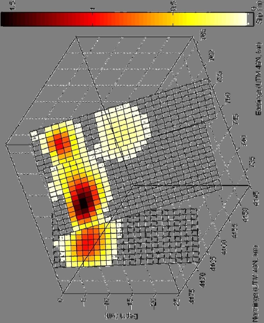
10 Modelling of the Interferograms Also used data from Envisat tracks 498A and 004D in the modelling 3 fault segments; 1 km resolution for the distributed slip model. Modelling showed rupture occurred along a length of about 75 km.

11 Surface Displacements for the Yushu Earthquake


12 Bodywave Modelling for the Yushu Earthquake Main points: Two peaks in the rate at which seismic moment was generated. Seismic moment is the main measure of earthquake excitation and is proportional to the amount of slip and the area on which it occurs. Best fit if assume SE propagation of rupture at ~2.5 km/s Centroid depth of 6 km

13 Moment Release Distribution and Surface Observations Li et al, JGR (in review) Majority of moment release above 10 km. Three slip patches. Test hypotheses that NW patch is due to the M w 6.1 aftershock.
14 Travel Time Differences between M w 6.1 Aftershock and Mainshock

15 Distributed Slip for the Yushu Earthquake N Yushu Geometry with propagation towards town at end of the fault is same as for the 2003 Bam earthquake. Slip deficit south of Yushu since last earthquake in 1896 is about 0.7m ( M w 6.5)

16 2008 and 2009 M w 6.3 Qaidam Basin Earthquakes Elliott et al, GRL (2011)

17 Faulting from ASTER Satellite Imagery

18 Faulting from ASTER Satellite Imagery

19 Envisat Interferograms for Qaidam Earthquakes Elliott et al, GRL (2011)
")
20 Evidence for Segmentation of a Fault with Depth Elliott et al, GRL (2011)
 Coulomb")
21 Coulomb Stress Changes due to the 2008 Earthquake Elliott et al, GRL (2011) Coulomb stress


22 Faulting and Focal Mechanisms for the Gowk Fault 1981 Mw 7.1 Sirch Earthquake 65 km long rupture Max 0.4 m surface offsets 18 km centroid Shallow dipping thrust 1998 Mw 6.8 Fandoqa Earthquake 20 km long rupture Max 3 m surface offsets 5 km centroid Strike slip with normal component Berberian et al., GJI (2001)
23 Conclusions Combining InSAR and seismology shows that the cause of the relatively large number of casualties from the 2010 Yushu earthquake was probably due to the propagation of the rupture along the fault towards the town, terminating there, combined with the vulnerability of the building stock. A similar scenario occurred for the Bam earthquake. In that case a strong motion accelerometer was available to provide independent evidence for the point of initiation of the rupture and hence the direction of propagation. The InSAR study of the closely separated 2008 and 2009 Qaidam earthquakes indicates segmentation of the fault with depth. Depth segmentation may occur where faults interact and the fault geometry is evolving. In such cases, just because a large earthquake has occurred at same location, it does not mean the immediate seismic hazard has gone away. The occurrence of earthquakes closely spaced in location and time may also lead to incompleteness in the palaeoseismological record.
24
25 Estimating the Length of the Fault from the Seismic Moment M 0 LW u Assume: = Pa, W = 15 km, u = 1.5 m, M 0 = N m (GCMT), then L = 35 km W =10 km and M 0 = Nm L = 42 km
26 Seismic Rupture in the Bam Earthquake Bam The coloured area is the patch on the fault that slipped in the earthquake as determined by modelling the radar interferometry observations. The circle shows the distance to the initial point of rupture from Bam determined from the recording of an accelerometer in Bam. The location of rupture initiation can be identified (blue circle). The rupture propagated from south to north. Jackson et al, GJI (2006)


27 Slip Distributions
Buried Strike Slip Faults: The 1994 and 2004 Al Hoceima, Morocco Earthquakes.
 Buried Strike Slip Faults: The 1994 and 2004 Al Hoceima, Morocco Earthquakes. Juliet Biggs 1, Eric Bergman 2, Brian Emmerson 3, Gareth Funning 4, James Jackson 3, Barry Parsons 1,Tim Wright 1. 1 COMET,
Basics of the modelling of the ground deformations produced by an earthquake. EO Summer School 2014 Frascati August 13 Pierre Briole
 Basics of the modelling of the ground deformations produced by an earthquake EO Summer School 2014 Frascati August 13 Pierre Briole Content Earthquakes and faults Examples of SAR interferograms of earthquakes
Joint inversion of InSAR and broadband teleseismic waveform data with ABIC: application to the 1997 Manyi, Tibet earthquake
 Joint inversion of InSAR and broadband teleseismic waveform data with ABIC: application to the 1997 Manyi, Tibet earthquake Gareth Funning 1, Yukitoshi Fukahata 2, Yuji Yagi 3 & Barry Parsons 4 1 University
JCR (2 ), JGR- (1 ) (4 ) 11, EPSL GRL BSSA
, JGR- (1 ) (4 ) 11, EPSL GRL BSSA") Dun Wang ( ) In collaboration with: Hitoshi Kawakatsu, Jim Mori, Kazuki Koketsu, Takuto Maeda, Hiroshi Tsuroka, Jiancang Zhunag, Lihua Fang, and Qiang Yao School of Geosciences, China University of Geosciences
Dun Wang ( ) In collaboration with: Hitoshi Kawakatsu, Jim Mori, Kazuki Koketsu, Takuto Maeda, Hiroshi Tsuroka, Jiancang Zhunag, Lihua Fang, and Qiang Yao School of Geosciences, China University of Geosciences
The March 11, 2011, Tohoku-oki earthquake (Japan): surface displacement and source modelling
: surface displacement and source modelling") The March 11, 2011, Tohoku-oki earthquake (Japan): surface displacement and source modelling Salvatore Stramondo Bignami C., Borgstrom S., Chini M., Guglielmino F., Melini D., Puglisi G., Siniscalchi V.,
The March 11, 2011, Tohoku-oki earthquake (Japan): surface displacement and source modelling Salvatore Stramondo Bignami C., Borgstrom S., Chini M., Guglielmino F., Melini D., Puglisi G., Siniscalchi V.,
Widespread Ground Motion Distribution Caused by Rupture Directivity during the 2015 Gorkha, Nepal Earthquake
 Widespread Ground Motion Distribution Caused by Rupture Directivity during the 2015 Gorkha, Nepal Earthquake Kazuki Koketsu 1, Hiroe Miyake 2, Srinagesh Davuluri 3 and Soma Nath Sapkota 4 1. Corresponding
Magnitude 7.1 NEAR THE EAST COAST OF HONSHU, JAPAN
 Japan was rattled by a strong aftershock and tsunami warning Thursday night nearly a month after a devastating earthquake and tsunami flattened the northeastern coast. This earthquake can be considered
Chapter 2. Earthquake and Damage
 EDM Report on the Chi-Chi, Taiwan Earthquake of September 21, 1999 2.1 Earthquake Fault 2.1.1 Tectonic Background The island of Taiwan is located in the complex junction where the Eurasian and Philippine
Magnitude 7.6 & 7.4 SOLOMON ISLANDS
 A magnitude 7.6 earthquake struck near the Solomon Islands on Sunday morning local time; there were no immediate reports of damage. The earthquake was centered 100 km (60 miles) south of Kira Kira, a town
Magnitude 8.2 NORTHWEST OF IQUIQUE, CHILE
 An 8.2-magnitude earthquake struck off the coast of northern Chile, generating a local tsunami. The USGS reported the earthquake was centered 95 km (59 miles) northwest of Iquique at a depth of 20.1km
RELOCATION OF THE MACHAZE AND LACERDA EARTHQUAKES IN MOZAMBIQUE AND THE RUPTURE PROCESS OF THE 2006 Mw7.0 MACHAZE EARTHQUAKE
 RELOCATION OF THE MACHAZE AND LACERDA EARTHQUAKES IN MOZAMBIQUE AND THE RUPTURE PROCESS OF THE 2006 Mw7.0 MACHAZE EARTHQUAKE Paulino C. FEITIO* Supervisors: Nobuo HURUKAWA** MEE07165 Toshiaki YOKOI** ABSTRACT
Preliminary slip model of M9 Tohoku earthquake from strongmotion stations in Japan - an extreme application of ISOLA code.
 Preliminary slip model of M9 Tohoku earthquake from strongmotion stations in Japan - an extreme application of ISOLA code. J. Zahradnik 1), F. Gallovic 1), E. Sokos 2) G-A. Tselentis 2) 1) Charles University
SOURCE INVERSION AND INUNDATION MODELING TECHNOLOGIES FOR TSUNAMI HAZARD ASSESSMENT, CASE STUDY: 2001 PERU TSUNAMI
 Paper No. TS-4-1 SOURCE INVERSION AND INUNDATION MODELING TECHNOLOGIES FOR TSUNAMI HAZARD ASSESSMENT, CASE STUDY: 2001 PERU TSUNAMI Bruno Adriano 1, Shunichi Koshimura 2 and Yushiro Fujii 3 ABSTRACT The
Magnitude 7.0 N of ANCHORAGE, ALASKA
 A magnitude 7.0 earthquake occurred just before 8:30 am local time 8 miles north of Anchorage at a depth of 40.9 km (25.4 miles). There are reports of major infrastructure damage and damage to many homes
Case Study 1: 2014 Chiang Rai Sequence
 Case Study 1: 2014 Chiang Rai Sequence Overview Mw 6.1 earthquake on 5 May 2014 at 11:08:43 UTC Largest recorded earthquake in Thailand Fault Orientation How does the orientation of the fault affect the
A New Perspective on Fault Geometry and Slip Distribution of the 2009 Dachaidan Mw 6.3 Earthquake from InSAR Observations
 Sensors 2015, 15, 16786-16803; doi:10.3390/s150716786 Article OPEN ACCESS sensors ISSN 1424-8220 www.mdpi.com/journal/sensors A New Perspective on Fault Geometry and Slip Distribution of the 2009 Dachaidan
Slip in the Canterbury earthquakes, New Zealand
 JOURNAL OF GEOPHYSICAL RESEARCH, VOL. 117,, doi:10.1029/2011jb008868, 2012 Slip in the 2010 2011 Canterbury earthquakes, New Zealand J. R. Elliott, 1 E. K. Nissen, 2 P. C. England, 1 J. A. Jackson, 2 S.
Journal of Geophysical Research - Solid Earth
 Journal of Geophysical Research - Solid Earth Supporting Information for Transpressional Rupture Cascade of the 2016 M w 7.8 Kaikoura Earthquake, New Zealand Wenbin Xu 1*, Guangcai Feng 2*, Lingsen Meng
Ground surface deformation of L Aquila. earthquake revealed by InSAR time series
 Ground surface deformation of L Aquila earthquake revealed by InSAR time series Reporter: Xiangang Meng Institution: First Crust Monitoring and Application Center, CEA Address: 7 Naihuo Road, Hedong District
Magnitude 7.2 OAXACA, MEXICO
 A magnitude 7.2 earthquake has occurred in Oaxaca, Mexico at a depth of 24.6 km (15 miles). It was felt as far away as Guatemala. There have been no reported deaths directly linked to the earthquake. Emergency
27th Seismic Research Review: Ground-Based Nuclear Explosion Monitoring Technologies
 GROUND TRUTH LOCATIONS USING SYNERGY BETWEEN REMOTE SENSING AND SEISMIC METHODS-APPLICATION TO CHINESE AND NORTH AFRICAN EARTHQUAKES C. K. Saikia 1, H. K. Thio 2, D. V. Helmberger 2, G. Ichinose 1, and
Preliminary report on the Canterbury Earthquake South Island of New Zealand , M 6.3
 Preliminary report on the Canterbury Earthquake South Island of New Zealand 21.02.2011, M 6.3 Kyriazis Pitilakis and the group of - Aristotle University Thessaloniki, Greece. General 2 General 147 people
Earthquake Source. Kazuki Koketsu. Special Session: Great East Japan (Tohoku) Earthquake. Earthquake Research Institute, University of Tokyo
 Earthquake. Earthquake Research Institute, University of Tokyo") 2012/9/24 17:20-17:35 WCEE SS24.4 Special Session: Great East Japan (Tohoku) Earthquake Earthquake Source Kazuki Koketsu Earthquake Research Institute, University of Tokyo 1 Names and features of the earthquake
2012/9/24 17:20-17:35 WCEE SS24.4 Special Session: Great East Japan (Tohoku) Earthquake Earthquake Source Kazuki Koketsu Earthquake Research Institute, University of Tokyo 1 Names and features of the earthquake
Low-Latency Earthquake Displacement Fields for Tsunami Early Warning and Rapid Response Support
 Low-Latency Earthquake Displacement Fields for Tsunami Early Warning and Rapid Response Support Hans-Peter Plag, Geoffrey Blewitt Nevada Bureau of Mines and Geology and Seismological Laboratory University
A GLOBAL SURGE OF GREAT EARTHQUAKES FROM AND IMPLICATIONS FOR CASCADIA. Thorne Lay, University of California Santa Cruz
 A GLOBAL SURGE OF GREAT EARTHQUAKES FROM 2004-2014 AND IMPLICATIONS FOR CASCADIA Thorne Lay, University of California Santa Cruz Last 10 yrs - 18 great earthquakes: rate 1.8/yr; rate over preceding century
Earthquakes and Faulting
 Earthquakes and Faulting Crustal Strength Profile Quakes happen in the strong, brittle layers Great San Francisco Earthquake April 18, 1906, 5:12 AM Quake lasted about 60 seconds San Francisco was devastated
(First Edition: prepared on 29/12/2003)
") (First Edition: prepared on 29/12/2003) Dr Sassan Eshghi 1 and Dr Mehdi Zaré 2 International Institute of Earthquake Engineering and Seismology, Tehran, P.O.Box: 19395/3913, IRAN e-mails: 1)s.eshghi@iiees.ac.ir,
(First Edition: prepared on 29/12/2003) Dr Sassan Eshghi 1 and Dr Mehdi Zaré 2 International Institute of Earthquake Engineering and Seismology, Tehran, P.O.Box: 19395/3913, IRAN e-mails: 1)s.eshghi@iiees.ac.ir,
GEO-VIII November Geohazard Supersites and Natural Laboratories Progress Report. Document 9
 GEO-VIII 16-17 November 2011 Geohazard Supersites and Natural Laboratories Progress Report Document 9 This document is submitted to GEO-VIII for information. Geohazard Supersites and Natural Laboratories
M-6.2 EARTHQUAKE NORCIA, ITALY AUGUST 24, 01:36:33 UTC
 M-6.2 EARTHQUAKE NORCIA, ITALY AUGUST 24, 2016 @ 01:36:33 UTC EARTHQUAKE REPORT - NORCIA, ITALY M-6.2, 24 August 2016 The M-6.2 earthquake had a shallow depth (10 km) and struck approximately 10 km SE
Empirical Green s Function Analysis of the Wells, Nevada, Earthquake Source
 Nevada Bureau of Mines and Geology Special Publication 36 Empirical Green s Function Analysis of the Wells, Nevada, Earthquake Source by Mendoza, C. 1 and Hartzell S. 2 1 Centro de Geociencias, Universidad
SUPPLEMENTARY INFORMATION
 doi:10.1038/nature11492 Figure S1 Short-period Seismic Energy Release Pattern Imaged by F-net. (a) Locations of broadband seismograph stations in Japanese F-net used for the 0.5-2.0 Hz P wave back-projection
The Impact of the 2010 Darfield (Canterbury) Earthquake on the Geodetic Infrastructure in New Zealand 1
 Earthquake on the Geodetic Infrastructure in New Zealand 1") The Impact of the 2010 Darfield (Canterbury) Earthquake on the Geodetic Infrastructure in New Zealand 1 Graeme BLICK, John BEAVAN, Chris CROOK, Nic DONNELLY Keywords: Darfield Earthquake, control, survey,
The Impact of the 2010 Darfield (Canterbury) Earthquake on the Geodetic Infrastructure in New Zealand 1 Graeme BLICK, John BEAVAN, Chris CROOK, Nic DONNELLY Keywords: Darfield Earthquake, control, survey,
Tsunami and earthquake in Chile Part 2
 EUROPEAN COMMISSION DIRECTORATE GENERAL JRC JOINT RESEARCH CENTRE Institute for the Protection and Security of the Citizen Global Security and Crisis Management Unit CriTech Sunday, 28 February 2010 Executive
The Seismic Hazardscape of New Zealand
 The Seismic Hazardscape of New Zealand Mark Stirling Professor of Earthquake Science Introduction Plate tectonic setting of New Zealand Seismic hazards for University of Otago campuses Kaikoura earthquake
Magnitude 7.3 NEPAL. Tuesday, May 12, 2015 at 07:05:19 UTC
 A magnitude 7.3 earthquake has occurred near Mount Everest. Early reports suggest 32 people have been killed and at least 1,000 were injured in the earthquake. The region is still in recovery from a 7.8
Was the February 2008 Bukavu seismic sequence associated with magma intrusion?
 Was the February 2008 Bukavu seismic sequence associated with magma intrusion? N. d Oreye, C. Lucas National Museum of Natural History, Luxembourg nicolas.doreye@ecgs.lu P. Gonzalez, J. Fernández Univ.
GEO-HAZARDS STUDIES BY PALSAR INTERFEROMETRY PI No: 390 Xiaoli Ding 1, Lei Zhang 1, Guangcai Feng 1, Mi Jiang 1, and Jun Hu 2, 1 The Hong Kong Polytec
 GEO-HAZARDS SUDIES BY PALSAR INERFEROMERY PI No: 390 Xiaoli Ding 1, Lei Zhang 1, Guangcai Feng 1, Mi Jiang 1, and Jun Hu 2, 1 he Hong Kong Polytechnic University, Hung Hom, KLN, Hong Kong 2 Central South
Journal of Geophysical Research Letters Supporting Information for
 Journal of Geophysical Research Letters Supporting Information for InSAR observations of strain accumulation and fault creep along the Chaman Fault system, Pakistan and Afghanistan H. Fattahi 1, F. Amelung
Source rupture process inversion of the 2013 Lushan earthquake, China
 Geodesy and Geodynamics 2013,4(2) :16-21 http://www. jgg09. com Doi:10.3724/SP.J.1246.2013.02016 Source rupture process inversion of the 2013 Lushan earthquake, China Zhang Lifen 1 ' 2, lman Fatchurochman
27th Seismic Research Review: Ground-Based Nuclear Explosion Monitoring Technologies
 GROUND TRUTH OF AFRICAN AND EASTERN MEDITERRANEAN SHALLOW SEISMICITY USING SAR INTERFEROMETRY AND GIBBS SAMPLING INVERSION Benjamin A. Brooks 1, Francisco Gomez 2, Eric A. Sandvol 2, and Neil Frazer 1
Three Fs of earthquakes: forces, faults, and friction. Slow accumulation and rapid release of elastic energy.
 Earthquake Machine Stick-slip: Elastic Rebound Theory Jerky motions on faults produce EQs Three Fs of earthquakes: forces, faults, and friction. Slow accumulation and rapid release of elastic energy. Three
S. Toda, S. Okada, D. Ishimura, and Y. Niwa International Research Institute of Disaster Science, Tohoku University, Japan
 The first surface-rupturing earthquake in 20 years on a HERP major active fault: Mw=6.2 2014 Nagano, Japan, event along the Itoigawa-Shizuoka Tectonic Line is not characteristic S. Toda, S. Okada, D. Ishimura,
Earthquakes. Earthquake Magnitudes 10/1/2013. Environmental Geology Chapter 8 Earthquakes and Related Phenomena
 Environmental Geology Chapter 8 Earthquakes and Related Phenomena Fall 2013 Northridge 1994 Kobe 1995 Mexico City 1985 China 2008 Earthquakes Earthquake Magnitudes Earthquake Magnitudes Richter Magnitude
DETECTION OF CRUSTAL DEFORMATION OF THE NORTHERN PAKISTAN EARTHQUAKE BY SATELLITE DATA. Submitted by Japan **
 UNITED NATIONS E/CONF.97/5/CRP. 5 ECONOMIC AND SOCIAL COUNCIL Seventeenth United Nations Regional Cartographic Conference for Asia and the Pacific Bangkok, 18-22 September 2006 Item 6 (b) of the provisional
Tsunami waves swept away houses and cars in northern Japan and pushed ships aground.
 Japan was struck by a magnitude 8.9 earthquake off its northeastern coast Friday. This is one of the largest earthquakes that Japan has ever experienced. In downtown Tokyo, large buildings shook violently
Case Study 2: 2014 Iquique Sequence
 Case Study 2: 2014 Iquique Sequence Overview Mw 8.2 earthquake on 1 April 2014 at 11:08:43 UTC Pictures of damage Seismicity maps Foreshock seismicity -> Main shock -> Aftershock 1 April 2014 11:08:43
Geodesy (InSAR, GPS, Gravity) and Big Earthquakes
 and Big Earthquakes") Geodesy (InSAR, GPS, Gravity) and Big Earthquakes Mathew Pritchard Teh-Ru A. Song Yuri Fialko Luis Rivera Mark Simons UJNR Earthquake Research Panel, Morioka, Japan - Nov 6, 2002 Goals Accurate and high
Geodesy (InSAR, GPS, Gravity) and Big Earthquakes Mathew Pritchard Teh-Ru A. Song Yuri Fialko Luis Rivera Mark Simons UJNR Earthquake Research Panel, Morioka, Japan - Nov 6, 2002 Goals Accurate and high
The U.S. Geological Survey (USGS) National Earthquake Information Center (NEIC)
 National Earthquake Information Center (NEIC)") The U.S. Geological Survey (USGS) National Earthquake Information Center (NEIC) Gavin Hayes U.S. Geological Survey, National Earthquake Information Center NEIC Mission NEIC - The People 24x7 Operations
The U.S. Geological Survey (USGS) National Earthquake Information Center (NEIC) Gavin Hayes U.S. Geological Survey, National Earthquake Information Center NEIC Mission NEIC - The People 24x7 Operations
Mw 7.8, Southwest of Sumatra, Indonesia Wed, 2 March 2016 at 12:49:48 UTC M /03/03
 Earthquake overview AFGHANISTA N PAKISTA N INDIA A moment magnitude (Mw) 7.8 earthquake struck in South West, Indonesia. The epicentre was centered about 800 km West South West of Padang, Sumatra province,
Magnitude 7.0 VANUATU
 A major earthquake struck in the southwest Pacific Ocean at a depth of 27 km beneath the island of Melampa in the Vanuatu island chain. There are no reports of damage. The Modified Mercalli Intensity (MMI)
Geometry of co-seismic surface ruptures and tectonic meaning of the 23 October 2011 Mw 7.1 Van earthquake (East Anatolian Region, Turkey)
") Geometry of co-seismic surface ruptures and tectonic meaning of the 23 October 2011 Mw 7.1 Van earthquake (East Anatolian Region, Turkey) Bülent Dogan & Ahmet Karakaș. Journal of Structural Geology, 46(2013),
Geometry of co-seismic surface ruptures and tectonic meaning of the 23 October 2011 Mw 7.1 Van earthquake (East Anatolian Region, Turkey) Bülent Dogan & Ahmet Karakaș. Journal of Structural Geology, 46(2013),
Magnitude 7.0 NEW CALEDONIA
 A magnitude 7.0 earthquake has occurred 82km ENE of Maré Island, the secondlargest of the Loyalty Islands in the archipelago of New Caledonia. The initial report of the magnitude and shallow 10km depth
28th Seismic Research Review: Ground-Based Nuclear Explosion Monitoring Technologies
 GROUND TRUTH LOCATIONS USING SYNERGY BETWEEN REMOTE SENSING AND SEISMIC METHODS: SSSC AT IMS STATIONS FOR TIBETAN PLATEAU EARTHQUAKES Gene A. Ichinose 1, Chandan K. Saikia 2*, Donald V. Helmberger 3, and
Geophysical Journal International
 Geophysical Journal International Geophys. J. Int. (2013) 193, 29 46 doi: 10.1093/gji/ggs102 Coseismic displacement field and slip distribution of the 2005 Kashmir earthquake from SAR amplitude image correlation
STRESS IN THE SYSTEM? INSIGHTS INTO MODELLING IN THE WAKE OF TOHOKU
 STRESS IN THE SYSTEM? INSIGHTS INTO MODELLING IN THE WAKE OF TOHOKU Aspen Re June 13, 2012 James Few President, Aspen Re Aspen Insurance Holdings Limited AGENDA Do we need near-term quake rates? Lessons
Displacement field and slip distribution of the 2005 Kashmir earthquake from SAR imagery
 Click Here for Full Article GEOPHYSICAL RESEARCH LETTERS, VOL. 33,, doi:10.1029/2006gl027193, 2006 Displacement field and slip distribution of the 2005 Kashmir earthquake from SAR imagery E. Pathier, 1
Line of Sight Displacement from ALOS-2 Interferometry: Mw 7.8 Gorkha Earthquake and Mw 7.3 Aftershock
 Line of Sight Displacement from ALOS-2 Interferometry: Mw 7.8 Gorkha Earthquake and Mw 7.3 Aftershock Eric O. Lindsey 1 Ryo Natsuaki 2 Xiaohua Xu 1 Masanobu Shimada 2 Manabu, Hashimoto 3 Diego Melgar 4
Megathrust earthquakes: How large? How destructive? How often? Jean-Philippe Avouac California Institute of Technology
 Megathrust earthquakes: How large? How destructive? How often? Jean-Philippe Avouac California Institute of Technology World seismicity (data source: USGS) and velocities relative to ITRF1997 (Sella et
Magnitude 7.1 PERU. There are early reports of homes and roads collapsed leaving one dead and several dozen injured.
 A magnitude 7.1 earthquake has occurred offshore Peru. The earthquake struck just after 4 a.m. local time and was centered near the coast of Peru, 40 km (25 miles) south-southwest of Acari, Peru at a depth
Magnitude 7.5 PALU, INDONESIA
 A magnitude 7.5 earthquake occurred 80.8 km (50.2 mi) north of Palu, Indonesia at a depth of 10 km (6.2 miles). This earthquake triggered a tsunami with wave heights up to 2 m (6.6 ft) that an official
Source studies of the ongoing ( ) sequence of recent large earthquakes in Canterbury
 sequence of recent large earthquakes in Canterbury") Source studies of the ongoing (00-0) sequence of recent large earthquakes in Canterbury C. Holden & J. Beavan GNS Science New Zealand) SUMMARY: On September, 00, a surface rupturing crustal earthquake
Source studies of the ongoing (00-0) sequence of recent large earthquakes in Canterbury C. Holden & J. Beavan GNS Science New Zealand) SUMMARY: On September, 00, a surface rupturing crustal earthquake
Yesterday scaling laws. An important one for seismic hazard analysis
 Yesterday scaling laws An important one for seismic hazard analysis Estimating the expected size of an earthquake expected on a fault for which the mapped length is known. Wells & Coppersmith, 1994 And
Shallow rupture of the 2011 Tarlay earthquake (M w 6.8), Eastern Myanmar.
, Eastern Myanmar.") Chapter 6 261 Shallow rupture of the 2011 Tarlay earthquake (M w 6.8), Eastern Myanmar. Yu Wang 1, 2, Yu-Nung Nina Lin 1, Mark Simons 3, Soe Thura Tun 4 1. Division of Geological and Planetary Sciences,
Chapter 6 261 Shallow rupture of the 2011 Tarlay earthquake (M w 6.8), Eastern Myanmar. Yu Wang 1, 2, Yu-Nung Nina Lin 1, Mark Simons 3, Soe Thura Tun 4 1. Division of Geological and Planetary Sciences,
The 2003, M W 7.2 Fiordland Earthquake, and its nearsource aftershock strong motion data
 The 2003, M W 7.2 Fiordland Earthquake, and its nearsource aftershock strong motion data P. McGinty Institute of Geological & Nuclear Sciences, PO Box 30-368, Lower Hutt, New Zealand 2004 NZSEE Conference
Magnitude 7.0 PAPUA, INDONESIA
 A 7.0 magnitude earthquake struck eastern Indonesia's mountainous West Papua province on Saturday but there were no immediate reports of casualties or damage. The region is sparsely populated. According
Challenges of Applying Ground Motion Simulation to Earthquake Engineering
 Challenges of Applying Ground Motion Simulation to Earthquake Engineering Methodology of simulating ground motions from crustal earthquake and mega-thrust subduction earthquakes: application to the 2016
ESTIMATES OF HORIZONTAL DISPLACEMENTS ASSOCIATED WITH THE 1999 TAIWAN EARTHQUAKE
 ESTIMATES OF HORIZONTAL DISPLACEMENTS ASSOCIATED WITH THE 1999 TAIWAN EARTHQUAKE C. C. Chang Department of Surveying and Mapping Engineering Chung Cheng Institute of Technology, Taiwan, ROC ABSTRACT A
The Dahuiyeh (Zarand) earthquake of 2005 February 22 in central Iran: reactivation of an intramountain reverse fault
 earthquake of 2005 February 22 in central Iran: reactivation of an intramountain reverse fault") Geophys. J. Int. (2006) 164, 137 148 doi: 10.1111/j.1365-246X.2005.02839.x The Dahuiyeh (Zarand) earthquake of 2005 February 22 in central Iran: reactivation of an intramountain reverse fault M. Talebian,
Geophys. J. Int. (2006) 164, 137 148 doi: 10.1111/j.1365-246X.2005.02839.x The Dahuiyeh (Zarand) earthquake of 2005 February 22 in central Iran: reactivation of an intramountain reverse fault M. Talebian,
KUMAMOTO EARTHQUAKE (review)
") 1 平成 28 年熊本地震 KUMAMOTO EARTHQUAKE (review) Miroslav Hallo 1 ミロスラヴハロー 1 Charles University, Faculty of Mathematics and Physics, Czech Republic, チェコ Overview 2 Shallow earthquake sequence in central Kyushu
1 平成 28 年熊本地震 KUMAMOTO EARTHQUAKE (review) Miroslav Hallo 1 ミロスラヴハロー 1 Charles University, Faculty of Mathematics and Physics, Czech Republic, チェコ Overview 2 Shallow earthquake sequence in central Kyushu
Magnitude 6.3 SOUTH ISLAND OF NEW ZEALAND
 A magnitude 6.3 earthquake shook the southern New Zealand city of Christchurch. At least 100 people are reported dead, and there are reports of collapsed buildings, cracked streets and flooding due to
Earthquakes and Seismotectonics Chapter 5
 Earthquakes and Seismotectonics Chapter 5 What Creates Earthquakes? The term Earthquake is ambiguous: Applies to general shaking of the ground and to the source of the shaking We will talk about both,
Introduction to Displacement Modeling
 Introduction to Displacement Modeling Introduction Deformation on the Earth surface informs us about processes and material properties below surface Observation tools: GPS (static-dynamic) InSAR (static)
Rupture Characteristics of Major and Great (M w 7.0) Megathrust Earthquakes from : 1. Source Parameter Scaling Relationships
 Megathrust Earthquakes from : 1. Source Parameter Scaling Relationships") Journal of Geophysical Research Solid Earth Supporting Information for Rupture Characteristics of Major and Great (M w 7.0) Megathrust Earthquakes from 1990-2015: 1. Source Parameter Scaling Relationships
Journal of Geophysical Research Solid Earth Supporting Information for Rupture Characteristics of Major and Great (M w 7.0) Megathrust Earthquakes from 1990-2015: 1. Source Parameter Scaling Relationships
Seismic response of SDOF systems under doublet earthquakes. *Saman Yaghmaei-Sabegh 1)
") Seismic response of SDOF systems under doublet earthquakes *Saman Yaghmaei-Sabegh 1) 1) Department of Civil Engineering, University of Tabriz, Tabriz, Iran 1) s_yaghmaei@tabrizu.ac.ir ABSTRACT A single
Seismic response of SDOF systems under doublet earthquakes *Saman Yaghmaei-Sabegh 1) 1) Department of Civil Engineering, University of Tabriz, Tabriz, Iran 1) s_yaghmaei@tabrizu.ac.ir ABSTRACT A single
ShakeAlert Earthquake Early Warning
 ShakeAlert Earthquake Early Warning Doug Given USGS, Pasadena Earthquake Program, Early Warning Coordinator 10 seconds 50 seconds 90 seconds USGS Earthquake Hazard Responsibilities USGS has the lead federal
Surface ruptures and building damage of the 2003 Bam, Iran, earthquake mapped by satellite synthetic aperture radar interferometric correlation
 JOURNAL OF GEOPHYSICAL RESEARCH, VOL. 110,, doi:10.1029/2004jb003299, 2005 Surface ruptures and building damage of the 2003 Bam, Iran, earthquake mapped by satellite synthetic aperture radar interferometric
The Collaboratory for the Study of Earthquake Predictability: Perspectives on Evaluation & Testing for Seismic Hazard
 The Collaboratory for the Study of Earthquake Predictability: Perspectives on Evaluation & Testing for Seismic Hazard D. Schorlemmer, D. D. Jackson, J. D. Zechar, T. H. Jordan The fundamental principle
Magnitude 7.9 SE of KODIAK, ALASKA
 A magnitude 7.9 earthquake occurred at 12:31 am local time 181 miles southeast of Kodiak at a depth of 25 km (15.5 miles). There are no immediate reports of damage or fatalities. Light shaking from this
I. Locations of Earthquakes. Announcements. Earthquakes Ch. 5. video Northridge, California earthquake, lecture on Chapter 5 Earthquakes!
 51-100-21 Environmental Geology Summer 2006 Tuesday & Thursday 6-9:20 p.m. Dr. Beyer Earthquakes Ch. 5 I. Locations of Earthquakes II. Earthquake Processes III. Effects of Earthquakes IV. Earthquake Risk
RELATION BETWEEN RAYLEIGH WAVES AND UPLIFT OF THE SEABED DUE TO SEISMIC FAULTING
 13 th World Conference on Earthquake Engineering Vancouver, B.C., Canada August 1-6, 24 Paper No. 1359 RELATION BETWEEN RAYLEIGH WAVES AND UPLIFT OF THE SEABED DUE TO SEISMIC FAULTING Shusaku INOUE 1,
Part 2 - Engineering Characterization of Earthquakes and Seismic Hazard. Earthquake Environment
 Part 2 - Engineering Characterization of Earthquakes and Seismic Hazard Ultimately what we want is a seismic intensity measure that will allow us to quantify effect of an earthquake on a structure. S a
Evolution of the 2007 earthquake swarm, Tanzania: Envisat and ALOS interferometry, ground observations and elastic modeling
 Evolution of the 2007 earthquake swarm, Tanzania: Envisat and ALOS interferometry, ground observations and elastic modeling Gidon Baer, Yariv Hamiel, Gadi Shamir, Ran Nof Geological Survey of Israel East
6.0 TDMT, M W. IREA-CNR, Napoli, Italy 2. DISPUTER, Università G. D Annunzio, Chieti, Italy 3. Dipartimento della Protezione Civile, Roma, Italy
 An intriguing perspective on the source geometry and slip distribution of the 2016 Amatrice Mw 6.2 earthquake (central Italy) from geological and satellite data P. Tizzani 1, M. Bonano 1, P. Boncio 2,
INGV. Giuseppe Pezzo. Istituto Nazionale di Geofisica e Vulcanologia, CNT, Roma. Sessione 1.1: Terremoti e le loro faglie
 Giuseppe Pezzo Istituto Nazionale di Geofisica e Vulcanologia, CNT, Roma giuseppe.pezzo@ingv.it The study of surface deformation is one of the most important topics to improve the knowledge of the deep
COULOMB STRESS CHANGES DUE TO RECENT ACEH EARTHQUAKES
 COULOMB STRESS CHANGES DUE TO RECENT ACEH EARTHQUAKES Madlazim Physics Department, Faculty Mathematics and Sciences of Surabaya State University (UNESA) Jl. Ketintang, Surabaya 60231, Indonesia. e-mail:
Jocelyn Karen Campbell
 THE UNCERTAINTIES IN ASSESSING THE IMPACT OF REGIONAL SEISMICITY AT THE WIL SITE Statement of Evidence by Jocelyn Karen Campbell A CANTERBURY FAULTS coded by type CHARACTERISTICS OF THRUST FAULTS IN CANTERBURY
Sendai Earthquake NE Japan March 11, Some explanatory slides Bob Stern, Dave Scholl, others updated March
 Sendai Earthquake NE Japan March 11, 2011 Some explanatory slides Bob Stern, Dave Scholl, others updated March 14 2011 Earth has 11 large plates and many more smaller ones. Plates are 100-200 km thick
EARTHQUAKE MODELLING. Algiers, Belhassen Tonat
 EARTHQUAKE MODELLING Algiers, 10.11.2011 Belhassen Tonat Basic terms Plate tectonics Basic terms Average Number of Earthquakes/Year (Global) Magnitude Average Annually 8 and higher 1 ¹ 7-7.9 17 ² 6-6.9
Centroid moment-tensor analysis of the 2011 Tohoku earthquake. and its larger foreshocks and aftershocks
 Earth Planets Space, 99, 1 8, 2011 Centroid moment-tensor analysis of the 2011 Tohoku earthquake and its larger foreshocks and aftershocks Meredith Nettles, Göran Ekström, and Howard C. Koss Lamont-Doherty
Dear editors and reviewer(s), thank for your comments and suggestions. Replies as follows:
, thank for your comments and suggestions. Replies as follows:") 1 2 3 4 5 6 7 8 9 10 11 12 13 14 15 16 17 18 19 20 21 22 23 24 25 26 27 28 29 30 31 32 33 34 35 36 37 38 39 40 41 42 Dear editors and reviewer(s), thank for your comments and suggestions. Replies as follows:
1 2 3 4 5 6 7 8 9 10 11 12 13 14 15 16 17 18 19 20 21 22 23 24 25 26 27 28 29 30 31 32 33 34 35 36 37 38 39 40 41 42 Dear editors and reviewer(s), thank for your comments and suggestions. Replies as follows:
Coulomb stress changes due to Queensland earthquakes and the implications for seismic risk assessment
 Coulomb stress changes due to Queensland earthquakes and the implications for seismic risk assessment Abstract D. Weatherley University of Queensland Coulomb stress change analysis has been applied in
INVESTIGATION OF EARTHQUAKE-CYCLE DEFORMATION IN TIBET FROM ALOS PALSAR DATA PI 168 Roland Bürgmann 1, Mong-Han Huang 1, Isabelle Ryder 2, and Eric Fi
 INVESTIGATION OF EARTHQUAKE-CYCLE DEFORMATION IN TIBET FROM ALOS PALSAR DATA PI 168 Roland Bürgmann 1, Mong-Han Huang 1, Isabelle Ryder 2, and Eric Fielding 3 1 Berkeley Seismological Laboratory, University
Magnitude 7.7 QUEEN CHARLOTTE ISLANDS REGION
 A major 7.7 magnitude earthquake struck at 8:04 PM local time in western British Columbia, Canada. The epicenter is located on Moresby Island, the southern large island in the Queen Charlotte Islands region.
Magnitude 7.6 HONDURAS
 A magnitude 7.6 earthquake has occurred in the Caribbean between Honduras and the Cayman Islands approximately 125 miles (202 km) north-northeast of Barra Patuca, Honduras, and 188 miles (303 km) southwest
A note on ground motion recorded during Mw 6.1 Mae Lao (Northern Thailand) earthquake on 5 May 2014
 earthquake on 5 May 2014") Proceedings of the Tenth Pacific Conference on Earthquake Engineering Building an Earthquake-Resilient Pacific 6-8 November 2015, Sydney, Australia A note on ground motion recorded during Mw 6.1 Mae Lao
Proceedings of the Tenth Pacific Conference on Earthquake Engineering Building an Earthquake-Resilient Pacific 6-8 November 2015, Sydney, Australia A note on ground motion recorded during Mw 6.1 Mae Lao
Centroid-moment-tensor analysis of the 2011 off the Pacific coast of Tohoku Earthquake and its larger foreshocks and aftershocks
 LETTER Earth Planets Space, 63, 519 523, 2011 Centroid-moment-tensor analysis of the 2011 off the Pacific coast of Tohoku Earthquake and its larger foreshocks and aftershocks Meredith Nettles, Göran Ekström,
PLATE DEFORMATION - 2
 H4.SMR/1775-24 "8th Workshop on Three-Dimensional Modelling of Seismic Waves Generation, Propagation and their Inversion" 25 September - 7 October 2006 PLATE DEFORMATION - 2 Roberto Sabadini Dipartimento
Magnitude 6.9 GULF OF CALIFORNIA
 A pair of strong earthquakes struck off the coast of Mexico early Thursday only minutes apart. The magnitude 6.9 and 6.2 were centered about 85 miles northeast of Guerrero Negro in the Mexican state of
Characteristics and introduction of Earthquake in Asia-Pacific region
 Characteristics and introduction of Earthquake in Asia-Pacific region 1906 San Francisco 2011 Tohoku 1999 Chi-Chi 1985 Mexico City 2004 Sumatra Chung-Han Chan 詹忠翰 2011 Christchurch To understand the characteristics
Post-seismic motion following the 1997 Manyi (Tibet) earthquake: InSAR observations and modelling
 earthquake: InSAR observations and modelling") Geophys. J. Int. (7) 69, 9 7 doi:./j.365-46x.6.33.x Post-seismic motion following the 997 Manyi (Tibet) earthquake: InSAR observations and modelling Isabelle Ryder, Barry Parsons, Tim J. Wright and Gareth
Geophys. J. Int. (7) 69, 9 7 doi:./j.365-46x.6.33.x Post-seismic motion following the 997 Manyi (Tibet) earthquake: InSAR observations and modelling Isabelle Ryder, Barry Parsons, Tim J. Wright and Gareth