Buried Strike Slip Faults: The 1994 and 2004 Al Hoceima, Morocco Earthquakes.
|
|
|
- Amberlynn Norton
- 6 years ago
- Views:
Transcription
1 Buried Strike Slip Faults: The 1994 and 2004 Al Hoceima, Morocco Earthquakes. Juliet Biggs 1, Eric Bergman 2, Brian Emmerson 3, Gareth Funning 4, James Jackson 3, Barry Parsons 1,Tim Wright 1. 1 COMET, Dept. of Earth Sciences. University of Oxford. 2 CIEI, Dept, of Physics, University of Colorado, Boulder 3 COMET, Dept. of Earth Sciences.University of Cambridge 4 Berkeley Seismological Laboratory, University of California, Berkeley
 Surface Rupture Denali")

2 Strike-Slip Slip Earthquakes: SURFACE RUPTURE BURIED (blind) Surface Rupture Denali Earthquake, Alaska Bam Earthquake, Iran 7m offset at surface 20 cm offset at surface 2 m at depth
3 Examples: Bam, Iran. (Funning et al, 2005, etc) Aiquile,, Bolivia. (Funning et al, 2005a ) Nenana Mountain, Alaska. (Wright et al, 2003) Al Hoceima,, Morocco, (this study) Al Hoceima,, Morocco, (this study) Difficult to identify from surface observations. MAJOR UNIDENTIFIED SEISMIC HAZARD.
4 Seismology
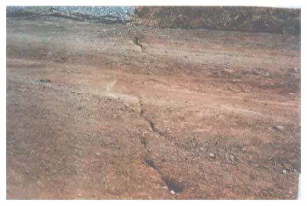
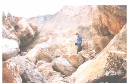
5 Auxilliary Plane Tension Compression Compression Tension Fault Plane
6 Geodesy


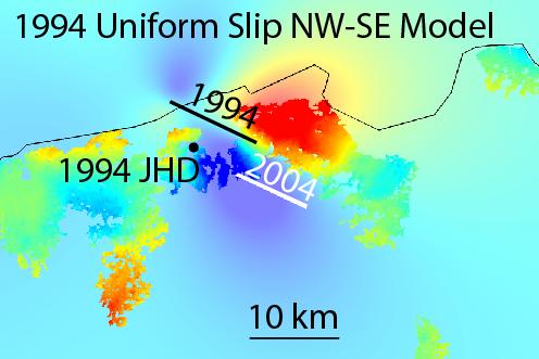
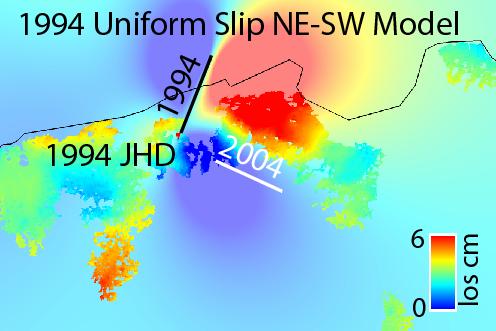
7 30 km Fault NW-SE Fault NE-SW Fault Descending Ascending
8 10 km Fault ~ M6 NW-SE Fault NE-SW Fault Descending Ascending


9 1 km Fault ~ Point Source NW-SE Fault NE-SW Fault Descending Ascending
10 2004 Earthquake

11 Al Hoceima Region Algeria


12 2004 Al Hoceima Earthquake M w th February ~600 dead. ~40,000 homeless.


13 2004 Al Hoceima : Surface Observations Institut Cartografic de Catalunya Rapport : GS-192/04 (fr)

14 2004 Al Hociema: Damage Map 20 km Area of soft sediments Ait Brahim et al, 2004

15 Preliminary Aftershock Locations
16 B I L L d M A 2 d Y AK d H I A d A R U d W M Q d A BK T d H Y B * d A T D d F U R I d K M B O d L S Z d T S U M d L V C d N N A d S D V d S JG d T E I G d H KT d T U C d R S S D d F F C d F R B d R E S d A LE d Nodal Planes: ~25 o ~295 o

17 2004 Coseismic Interferogram cm Ascending Track cm First Image: 10 th December 2003 Second Image: 7 th July 2004


18 Descending Interferogram cm cm First Image: 13 th April 2003 Second Image: 6 th June 2004
19


20 Interferograms Ascending Descending NW-SE Model NW-SE Residual Fault Length: 8.8 km Slip: 1.4 m Root Mean Square Misfit: 21 mm


21 Interferograms Ascending Descending NE-SW Model Fault Length: 1.1 km Slip: 12.9 m NE-SW Residual Root Mean Square Misfit: 23 mm
22 Slip to Length Ratios NE-SW Model NW-SE Model From Funning (2005).
23 Synthetic Experiment
24 Is this a general result or specific to Al Hoceima? Inversion assuming fault plane is fault plane Invent input earthquake parameters Produce Interferograms Compare output results to input Test effect of: fault orientation, atmospheric noise, coherence pattern. Inversion assuming auxiliary plane is fault plane

25 Ascending Descending Fault Length: 10 km Slip: 1 m Root Mean Square Misfit: 0.2 mm NW-SE Residual NW-SE Model Interferograms


26 Interferograms Ascending Descending NE-SW Model Fault Length: 2.0 km!! Slip: 9.1 m!! NE-SW Residual Root Mean Square Misfit: 6 mm
27 Slip to Length Ratios NE-SW Model Synthetic Parameters NW-SE Model
28 1994 Earthquake


29 1994 Al Hoceima Earthquake M w th May dead. Significant Damage
30 Preliminary Observations: Surface Observations
31 Preliminary Observations: Intensity Map

32 Location from Seismology Harvard CMT NEIC El Alami 1998 Calvert 1997

33 1994 Coseismic Interferogram.
34

35
36 Earthquake Sequence
37 Combining Seismology + InSAR to study earthquake sequences Seismology Detect Small Events Poor absolute location (but good relative location) InSAR Accurate absolute locations Events with significant surface deformation (i.e. shallow, M5-6+)
 Step 1: Relative locations of")


38 Hypocentroidal Decomposition Method (based on Jordan + Sverdrup, 1981) Step 1: Relative locations of events within cluster using seismology. Step 2: Absolute location of entire cluster use InSAR as ground truth. Relocate 58 Events: 10 associated with 1994 event 19 associated with 2004 event 2004 Earthquake 1994 Earthquake

39 Aftershocks not consistent with NW-SE fault plane for 1994 event. => Pair of conjugate faults.
40 Conjugate Fault System

41 Al Hoceima Earthquake Sequence:

42 Regional Context Strike Slip Thrust Faulting Tectonics of transition zone between Al Hoceima and El Asnam remains unclear. May only become clear once further larger earthquakes have occurred.
43 Conclusions Al Hoceima Earthquakes occurred on a conjugate fault system 2004 Al Hoceima Earthquake occurred on a NW-SE right-lateral fault Al Hoceima Earthquake occurred on a NE-SW left-lateral lateral fault. Significant seismic hazard associated with the region between Al Hoceima and El Asnam.
44
45
46

47 Variable Slip Model 0 Slip (m) Depth Peak Slip = 2.1 m At 8 km depth. 18 km 0 24 km Distance along strike
48


49 Errors on Slip Model. 0 Error (m) Depth 18 km 0 24 km Distance along strike
50 Monte Carlo Error Analysis Tradeoffs Create 100 perturbed datasets and analyse Identify tradeoffs and errors Strike Dip 180 Rake Slip Length 2 MinDepth
51 Strike Dip 180 Rake Strike ± 1.1 Dip 87.4 ± 1.5 Rake ± 1.2 Slip 1.4 m ± 0.1 Slip Length Length Min Depth 8.8 km ± km ± MinDepth
52
53 Resolution Inversion Depends on geometry between observation point and fault patch and smoothing factor.
54 Resolution

55 Recent Large Earthquakes Strike-slip Thrust
Joint inversion of InSAR and broadband teleseismic waveform data with ABIC: application to the 1997 Manyi, Tibet earthquake
 Joint inversion of InSAR and broadband teleseismic waveform data with ABIC: application to the 1997 Manyi, Tibet earthquake Gareth Funning 1, Yukitoshi Fukahata 2, Yuji Yagi 3 & Barry Parsons 4 1 University
Fault identification for buried strike-slip earthquakes using InSAR: The 1994 and 2004 Al Hoceima, Morocco earthquakes
 Geophys. J. Int. (2006) 166, 1347 1362 doi: 10.1111/j.1365-246X.2006.03071.x Fault identification for buried strike-slip earthquakes using InSAR: The 1994 and 2004 Al Hoceima, Morocco earthquakes Juliet
Two Contrasting InSAR Studies of Recent Earthquakes in Tibet
 Two Contrasting InSAR Studies of Recent Earthquakes in Tibet Barry Parsons Department of Earth Sciences University of Oxford John Elliott, Wanpeng Feng,, James Jackson, Zhenhong Li, Xinjian Shan, Alastair
27th Seismic Research Review: Ground-Based Nuclear Explosion Monitoring Technologies
 GROUND TRUTH OF AFRICAN AND EASTERN MEDITERRANEAN SHALLOW SEISMICITY USING SAR INTERFEROMETRY AND GIBBS SAMPLING INVERSION Benjamin A. Brooks 1, Francisco Gomez 2, Eric A. Sandvol 2, and Neil Frazer 1
Journal of Geophysical Research - Solid Earth
 Journal of Geophysical Research - Solid Earth Supporting Information for Transpressional Rupture Cascade of the 2016 M w 7.8 Kaikoura Earthquake, New Zealand Wenbin Xu 1*, Guangcai Feng 2*, Lingsen Meng
Journal of Geophysical Research Letters Supporting Information for
 Journal of Geophysical Research Letters Supporting Information for InSAR observations of strain accumulation and fault creep along the Chaman Fault system, Pakistan and Afghanistan H. Fattahi 1, F. Amelung
Displacement field and slip distribution of the 2005 Kashmir earthquake from SAR imagery
 Click Here for Full Article GEOPHYSICAL RESEARCH LETTERS, VOL. 33,, doi:10.1029/2006gl027193, 2006 Displacement field and slip distribution of the 2005 Kashmir earthquake from SAR imagery E. Pathier, 1
Surface displacements and source parameters of the 2003 Bam (Iran) earthquake from Envisat advanced synthetic aperture radar imagery
 earthquake from Envisat advanced synthetic aperture radar imagery") JOURNAL OF GEOPHYSICAL RESEARCH, VOL. 110,, doi:10.1029/2004jb003338, 2005 Surface displacements and source parameters of the 2003 Bam (Iran) earthquake from Envisat advanced synthetic aperture radar imagery
JOURNAL OF GEOPHYSICAL RESEARCH, VOL. 110,, doi:10.1029/2004jb003338, 2005 Surface displacements and source parameters of the 2003 Bam (Iran) earthquake from Envisat advanced synthetic aperture radar imagery
Geometry of co-seismic surface ruptures and tectonic meaning of the 23 October 2011 Mw 7.1 Van earthquake (East Anatolian Region, Turkey)
") Geometry of co-seismic surface ruptures and tectonic meaning of the 23 October 2011 Mw 7.1 Van earthquake (East Anatolian Region, Turkey) Bülent Dogan & Ahmet Karakaș. Journal of Structural Geology, 46(2013),
Geometry of co-seismic surface ruptures and tectonic meaning of the 23 October 2011 Mw 7.1 Van earthquake (East Anatolian Region, Turkey) Bülent Dogan & Ahmet Karakaș. Journal of Structural Geology, 46(2013),
Global compilation of interferometric synthetic aperture radar earthquake source models: 2. Effects of 3 D Earth structure
 JOURNAL OF GEOPHYSICAL RESEARCH, VOL. 116,, doi:10.1029/2010jb008132, 2011 Global compilation of interferometric synthetic aperture radar earthquake source models: 2. Effects of 3 D Earth structure A.
Earthquakes and Faulting
 Earthquakes and Faulting Crustal Strength Profile Quakes happen in the strong, brittle layers Great San Francisco Earthquake April 18, 1906, 5:12 AM Quake lasted about 60 seconds San Francisco was devastated
RELOCATION OF THE MACHAZE AND LACERDA EARTHQUAKES IN MOZAMBIQUE AND THE RUPTURE PROCESS OF THE 2006 Mw7.0 MACHAZE EARTHQUAKE
 RELOCATION OF THE MACHAZE AND LACERDA EARTHQUAKES IN MOZAMBIQUE AND THE RUPTURE PROCESS OF THE 2006 Mw7.0 MACHAZE EARTHQUAKE Paulino C. FEITIO* Supervisors: Nobuo HURUKAWA** MEE07165 Toshiaki YOKOI** ABSTRACT
The March 11, 2011, Tohoku-oki earthquake (Japan): surface displacement and source modelling
: surface displacement and source modelling") The March 11, 2011, Tohoku-oki earthquake (Japan): surface displacement and source modelling Salvatore Stramondo Bignami C., Borgstrom S., Chini M., Guglielmino F., Melini D., Puglisi G., Siniscalchi V.,
The March 11, 2011, Tohoku-oki earthquake (Japan): surface displacement and source modelling Salvatore Stramondo Bignami C., Borgstrom S., Chini M., Guglielmino F., Melini D., Puglisi G., Siniscalchi V.,
Interseismic slip rate of the northwestern Xianshuihe fault from InSAR data
 Click Here for Full Article GEOPHYSICAL RESEARCH LETTERS, VOL. 36, L03302, doi:10.1029/2008gl036560, 2009 Interseismic slip rate of the northwestern Xianshuihe fault from InSAR data H. Wang, 1,2 T. J.
to: Interseismic strain accumulation and the earthquake potential on the southern San
 Supplementary material to: Interseismic strain accumulation and the earthquake potential on the southern San Andreas fault system by Yuri Fialko Methods The San Bernardino-Coachella Valley segment of the
27th Seismic Research Review: Ground-Based Nuclear Explosion Monitoring Technologies
 GROUND TRUTH LOCATIONS USING SYNERGY BETWEEN REMOTE SENSING AND SEISMIC METHODS-APPLICATION TO CHINESE AND NORTH AFRICAN EARTHQUAKES C. K. Saikia 1, H. K. Thio 2, D. V. Helmberger 2, G. Ichinose 1, and
Interseismic strain accumulation across the Manyi fault (Tibet) prior to the 1997 M w 7.6 earthquake
 prior to the 1997 M w 7.6 earthquake") GEOPHYSICAL RESEARCH LETTERS, VOL. 38,, doi:10.1029/2011gl049762, 2011 Interseismic strain accumulation across the Manyi fault (Tibet) prior to the 1997 M w 7.6 earthquake M. A. Bell, 1 J. R. Elliott,
GEOPHYSICAL RESEARCH LETTERS, VOL. 38,, doi:10.1029/2011gl049762, 2011 Interseismic strain accumulation across the Manyi fault (Tibet) prior to the 1997 M w 7.6 earthquake M. A. Bell, 1 J. R. Elliott,
Global compilation of interferometric synthetic aperture radar earthquake source models: 1. Comparisons with seismic catalogs
 JOURNAL OF GEOPHYSICAL RESEARCH, VOL. 116,, doi:10.1029/2010jb008131, 2011 Global compilation of interferometric synthetic aperture radar earthquake source models: 1. Comparisons with seismic catalogs
Was the February 2008 Bukavu seismic sequence associated with magma intrusion?
 Was the February 2008 Bukavu seismic sequence associated with magma intrusion? N. d Oreye, C. Lucas National Museum of Natural History, Luxembourg nicolas.doreye@ecgs.lu P. Gonzalez, J. Fernández Univ.
24th Seismic Research Review Nuclear Explosion Monitoring: Innovation and Integration
 A REFERENCE DATA SET FOR VALIDATING 3-D MODELS E. R. Engdahl, Eric A. Bergman, Michael H. Ritzwoller, Nikolai M. Shapiro and Anatoli L. Levshin University of Colorado, Boulder Sponsored by Defense Threat
DIRECT HAZARD ANALYSIS OF INELASTIC RESPONSE SPECTRA
 DIRECT HAZARD ANALYSIS OF INELASTIC RESPONSE SPECTRA ABSTRACT Y. Bozorgnia, M. Hachem, and K.W. Campbell Associate Director, PEER, University of California, Berkeley, California, USA Senior Associate,
The Size and Duration of the Sumatra-Andaman Earthquake from Far-Field Static Offsets
 The Size and Duration of the Sumatra-Andaman Earthquake from Far-Field Static Offsets P. Banerjee, 1 F. F. Pollitz, 2 R. Bürgmann 3 * 1 Wadia Institute of Himalayan Geology, Dehra Dun, 248001, India. 2
Earthquakes and Seismotectonics Chapter 5
 Earthquakes and Seismotectonics Chapter 5 What Creates Earthquakes? The term Earthquake is ambiguous: Applies to general shaking of the ground and to the source of the shaking We will talk about both,
SUPPLEMENTARY INFORMATION
 SUPPLEMENTARY INFORMATION DOI: 1.138/NGEO177 The Long Precursory Phase of Most Large Interplate Earthquakes Supplementary Information Supplementary Methods 1. Data and Classification We select the earthquakes
Co-seismic slip from the July 30, 1995, M w 8.1 Antofagasta, Chile, earthquake as constrained by InSAR and GPS observations
 98 Chapter 3 Co-seismic slip from the July 30, 1995, M w 8.1 Antofagasta, Chile, earthquake as constrained by InSAR and GPS observations Published by Blackwell Publishing Ltd. in Geophysical Journal International
Rudbar Lorestan Dam Design and local Faults
 Abstract Rudbar Lorestan Dam Design and local Faults Mahdavian Abbas Academic members, Dep. of Civil Eng. Power and Water University of Technology, Tehran, Iran Email: mahdavian@pwut.ac.ir The Rudbar Lorestan
The Impact of the 2010 Darfield (Canterbury) Earthquake on the Geodetic Infrastructure in New Zealand 1
 Earthquake on the Geodetic Infrastructure in New Zealand 1") The Impact of the 2010 Darfield (Canterbury) Earthquake on the Geodetic Infrastructure in New Zealand 1 Graeme BLICK, John BEAVAN, Chris CROOK, Nic DONNELLY Keywords: Darfield Earthquake, control, survey,
The Impact of the 2010 Darfield (Canterbury) Earthquake on the Geodetic Infrastructure in New Zealand 1 Graeme BLICK, John BEAVAN, Chris CROOK, Nic DONNELLY Keywords: Darfield Earthquake, control, survey,
Received 17 June 2011; revised 20 March 2013; accepted 7 June 2013; published 27 August 2013.
 JOURNAL OF GEOPHYSICAL RESEARCH: SOLID EARTH, VOL. 118, 4599 4627, doi:1.12/jgrb.5244, 213 A three-step maximum a posteriori probability method for InSAR data inversion of coseismic rupture with application
Post-seismic motion following the 1997 Manyi (Tibet) earthquake: InSAR observations and modelling
 earthquake: InSAR observations and modelling") Geophys. J. Int. (7) 69, 9 7 doi:./j.365-46x.6.33.x Post-seismic motion following the 997 Manyi (Tibet) earthquake: InSAR observations and modelling Isabelle Ryder, Barry Parsons, Tim J. Wright and Gareth
Geophys. J. Int. (7) 69, 9 7 doi:./j.365-46x.6.33.x Post-seismic motion following the 997 Manyi (Tibet) earthquake: InSAR observations and modelling Isabelle Ryder, Barry Parsons, Tim J. Wright and Gareth
Geophysical Journal International
 Geophysical Journal International Geophys. J. Int. (2013) 193, 29 46 doi: 10.1093/gji/ggs102 Coseismic displacement field and slip distribution of the 2005 Kashmir earthquake from SAR amplitude image correlation
Geodesy (InSAR, GPS, Gravity) and Big Earthquakes
 and Big Earthquakes") Geodesy (InSAR, GPS, Gravity) and Big Earthquakes Mathew Pritchard Teh-Ru A. Song Yuri Fialko Luis Rivera Mark Simons UJNR Earthquake Research Panel, Morioka, Japan - Nov 6, 2002 Goals Accurate and high
Geodesy (InSAR, GPS, Gravity) and Big Earthquakes Mathew Pritchard Teh-Ru A. Song Yuri Fialko Luis Rivera Mark Simons UJNR Earthquake Research Panel, Morioka, Japan - Nov 6, 2002 Goals Accurate and high
Auxiliary Material for The 2010 Maule, Chile earthquake: Downdip rupture limit revealed by space geodesy
 1 2 Auxiliary Material for The 2010 Maule, Chile earthquake: Downdip rupture limit revealed by space geodesy 3 4 5 6 Xiaopeng Tong 1, David Sandwell 1, Karen Luttrell 1, Benjamin Brooks 2, Michael Bevis
Widespread Ground Motion Distribution Caused by Rupture Directivity during the 2015 Gorkha, Nepal Earthquake
 Widespread Ground Motion Distribution Caused by Rupture Directivity during the 2015 Gorkha, Nepal Earthquake Kazuki Koketsu 1, Hiroe Miyake 2, Srinagesh Davuluri 3 and Soma Nath Sapkota 4 1. Corresponding
Dear editors and reviewer(s), thank for your comments and suggestions. Replies as follows:
, thank for your comments and suggestions. Replies as follows:") 1 2 3 4 5 6 7 8 9 10 11 12 13 14 15 16 17 18 19 20 21 22 23 24 25 26 27 28 29 30 31 32 33 34 35 36 37 38 39 40 41 42 Dear editors and reviewer(s), thank for your comments and suggestions. Replies as follows:
1 2 3 4 5 6 7 8 9 10 11 12 13 14 15 16 17 18 19 20 21 22 23 24 25 26 27 28 29 30 31 32 33 34 35 36 37 38 39 40 41 42 Dear editors and reviewer(s), thank for your comments and suggestions. Replies as follows:
Kinematics of the Southern California Fault System Constrained by GPS Measurements
 Title Page Kinematics of the Southern California Fault System Constrained by GPS Measurements Brendan Meade and Bradford Hager Three basic questions Large historical earthquakes One basic question How
7 Ground Motion Models
 7 Ground Motion Models 7.1 Introduction Ground motion equations are often called attenution relations but they describe much more than just the attenutation of the ground motion; they describe the probability
A New Perspective on Fault Geometry and Slip Distribution of the 2009 Dachaidan Mw 6.3 Earthquake from InSAR Observations
 Sensors 2015, 15, 16786-16803; doi:10.3390/s150716786 Article OPEN ACCESS sensors ISSN 1424-8220 www.mdpi.com/journal/sensors A New Perspective on Fault Geometry and Slip Distribution of the 2009 Dachaidan
Surface Rupture in Kinematic Ruptures Models for Hayward Fault Scenario Earthquakes
 Surface Rupture in Kinematic Ruptures Models for Hayward Fault Scenario Earthquakes Brad Aagaard May 21, 2009 Surface Rupture from Kinematic Rupture Models Objective Holistic approach to calculating surface
Crustal deformation in Taiwan: Results from finite source inversions of six M w > 5.8 Chi-Chi aftershocks
 JOURNAL OF GEOPHYSICAL RESEARCH, VOL. 109,, doi:10.1029/2003jb002606, 2004 Crustal deformation in Taiwan: Results from finite source inversions of six M w > 5.8 Chi-Chi aftershocks Wu-Cheng Chi 1 and Doug
Basics of the modelling of the ground deformations produced by an earthquake. EO Summer School 2014 Frascati August 13 Pierre Briole
 Basics of the modelling of the ground deformations produced by an earthquake EO Summer School 2014 Frascati August 13 Pierre Briole Content Earthquakes and faults Examples of SAR interferograms of earthquakes
Ground surface deformation of L Aquila. earthquake revealed by InSAR time series
 Ground surface deformation of L Aquila earthquake revealed by InSAR time series Reporter: Xiangang Meng Institution: First Crust Monitoring and Application Center, CEA Address: 7 Naihuo Road, Hedong District
Sendai Earthquake NE Japan March 11, Some explanatory slides Bob Stern, Dave Scholl, others updated March
 Sendai Earthquake NE Japan March 11, 2011 Some explanatory slides Bob Stern, Dave Scholl, others updated March 14 2011 Earth has 11 large plates and many more smaller ones. Plates are 100-200 km thick
2 compared with the uncertainty in relative positioning of the initial triangulation (30 { 50 mm, equivalent to an angular uncertainty of 2 p.p.m. ove
 Reply to: `Comment on \Geodetic investigation of the 13 May 1995 Kozani { Grevena (Greece) earthquake" by Clarke et al.' by Meyer et al. P. J. Clarke, 1 D. Paradissis, 2 P. Briole, 3 P. C. England, 1 B.
Constraints on fault and lithosphere rheology from the coseismic slip and postseismic afterslip of the 2006 M w 7.0 Mozambique earthquake
 JOURNAL OF GEOPHYSICAL RESEARCH, VOL. 117,, doi:10.1029/2011jb008580, 2012 Constraints on fault and lithosphere rheology from the coseismic slip and postseismic afterslip of the 2006 M w 7.0 Mozambique
14 S. 11/12/96 Mw S. 6/23/01 Mw S 20 S 22 S. Peru. 7/30/95 Mw S. Chile. Argentina. 26 S 10 cm 76 W 74 W 72 W 70 W 68 W
 175 Chapter 5 Comparision of co-seismic and post-seismic slip from the November 12, 1996, M w 7.7 and the June 23, 2001, M w 8.4 southern Peru subduction zone earthquakes 176 Abstract We use InSAR and
Journal of Geophysical Research (Solid Earth) Supporting Information for
 Supporting Information for") Journal of Geophysical Research (Solid Earth) Supporting Information for Postseismic Relocking of the Subduction Megathrust Following the 2007 Pisco, Peru earthquake D.Remy (a), H.Perfettini (b), N.Cotte
Journal of Geophysical Research (Solid Earth) Supporting Information for Postseismic Relocking of the Subduction Megathrust Following the 2007 Pisco, Peru earthquake D.Remy (a), H.Perfettini (b), N.Cotte
Empirical Green s Function Analysis of the Wells, Nevada, Earthquake Source
 Nevada Bureau of Mines and Geology Special Publication 36 Empirical Green s Function Analysis of the Wells, Nevada, Earthquake Source by Mendoza, C. 1 and Hartzell S. 2 1 Centro de Geociencias, Universidad
BEYOND TRAVELTIMES AND EARTHQUAKE LOCATION What else can seismograms tell us about the nature of earthquakes on faults?
 BEYOND TRAVELTIMES AND EARTHQUAKE LOCATION What else can seismograms tell us about the nature of earthquakes on faults? What are some of the key parameters which we describe faults? GEOMETRICAL PROPERTIES
Today: Basic regional framework. Western U.S. setting Eastern California Shear Zone (ECSZ) 1992 Landers EQ 1999 Hector Mine EQ Fault structure
 1992 Landers EQ 1999 Hector Mine EQ Fault structure") Today: Basic regional framework Western U.S. setting Eastern California Shear Zone (ECSZ) 1992 Landers EQ 1999 Hector Mine EQ Fault structure 1 2 Mojave and Southern Basin and Range - distribution of strike-slip
Today: Basic regional framework Western U.S. setting Eastern California Shear Zone (ECSZ) 1992 Landers EQ 1999 Hector Mine EQ Fault structure 1 2 Mojave and Southern Basin and Range - distribution of strike-slip
Tectonophysics (2012) Contents lists available at SciVerse ScienceDirect. Tectonophysics
 Contents lists available at SciVerse ScienceDirect. Tectonophysics") Tectonophysics 53 535 (1) 1 1 Contents lists available at SciVerse ScienceDirect Tectonophysics journal homepage: www.elsevier.com/locate/tecto Review Article Systematic comparisons of earthquake source
Tectonophysics 53 535 (1) 1 1 Contents lists available at SciVerse ScienceDirect Tectonophysics journal homepage: www.elsevier.com/locate/tecto Review Article Systematic comparisons of earthquake source
Multi-interferogram method for measuring interseismic deformation: Denali Fault, Alaska
 Geophys. J. Int. (27) 17, 1165 1179 doi: 1.1111/j.1365-246X.27.3415.x Multi-interferogram method for measuring interseismic deformation: Denali Fault, Alaska Juliet Biggs, 1 Tim Wright, 2 Zhong Lu 3 and
THE INTERPRETATION OF BAM FAULT KINEMATICS USING ENVISAT SAR INTERFEROMETRIC DATA
 THE INTERPRETATION OF BAM FAULT KINEMATICS USING ENVISAT SAR INTERFEROMETRIC DATA Zbigniew Perski (1), Ramon Hanssen (1) (1) Delft Institute for Earth Observation and Space Systems, Delft University of
Shallow intraplate earthquakes in Western Australia observed by Interferometric Synthetic Aperture Radar
 Click Here for Full Article JOURNAL OF GEOPHYSICAL RESEARCH, VOL. 113,, doi:10.1029/2008jb005807, 2008 Shallow intraplate earthquakes in Western Australia observed by Interferometric Synthetic Aperture
Tandem afterslip on connected fault planes following the 2008 Nima-Gaize (Tibet) earthquake
 earthquake") Click Here for Full Article JOURNAL OF GEOPHYSICAL RESEARCH, VOL. 115,, doi:10.1029/2009jb006423, 2010 Tandem afterslip on connected fault planes following the 2008 Nima-Gaize (Tibet) earthquake I. Ryder,
Click Here for Full Article JOURNAL OF GEOPHYSICAL RESEARCH, VOL. 115,, doi:10.1029/2009jb006423, 2010 Tandem afterslip on connected fault planes following the 2008 Nima-Gaize (Tibet) earthquake I. Ryder,
EARTHQUAKE LOCATION ACCURACY IN THE ARABIAN-EURASIAN COLLISION ZONE. Sponsored by Air Force Research Laboratory 1
 EARTHQUAKE LOCATION ACCURACY IN THE ARABIAN-EURASIAN COLLISION ZONE Eric A. Bergman, Eric R. Engdahl, Michael H. Ritzwoller, and Stephen C. Myers 2 University of Colorado and Lawrence Livermore National
STRONG GROUND MOTION PARAMETERS OF FEBRUARY 22, 2005 DAHUIYEH (ZARAND) EARTHQUAKE IN CENTRAL IRAN
 EARTHQUAKE IN CENTRAL IRAN") STRONG GROUND MOTION PARAMETERS OF FEBRUARY, 5 DAHUIYEH (ZARAND) EARTHQUAKE IN CENTRAL IRAN A. Babaie Mahani, J. Kazemian Address: Institute of Geophysics, University of Tehran, P.O. Box 55-666, Tehran,
STRONG GROUND MOTION PARAMETERS OF FEBRUARY, 5 DAHUIYEH (ZARAND) EARTHQUAKE IN CENTRAL IRAN A. Babaie Mahani, J. Kazemian Address: Institute of Geophysics, University of Tehran, P.O. Box 55-666, Tehran,
Tsunami waveform analyses of the 2006 underthrust and 2007 outer-rise Kurile earthquakes
 Author(s) 2008. This work is licensed under a Creative Commons License. Advances in Geosciences Tsunami waveform analyses of the 2006 underthrust and 2007 outer-rise Kurile earthquakes Y. Tanioka 1, Y.
Evaluation of earthquake triggering during the earthquake sequence on Qeshm Island, Iran
 JOURNAL OF GEOPHYSICAL RESEARCH, VOL. 115,, doi:10.1029/2010jb007710, 2010 Evaluation of earthquake triggering during the 2005 2008 earthquake sequence on Qeshm Island, Iran R. B. Lohman 1 and W. D. Barnhart
Evolution of the 2007 earthquake swarm, Tanzania: Envisat and ALOS interferometry, ground observations and elastic modeling
 Evolution of the 2007 earthquake swarm, Tanzania: Envisat and ALOS interferometry, ground observations and elastic modeling Gidon Baer, Yariv Hamiel, Gadi Shamir, Ran Nof Geological Survey of Israel East
Location and mechanism of the Little Skull Mountain earthquake as constrained by satellite radar interferometry and seismic waveform modeling
 JOURNAL OF GEOPHYSICAL RESEARCH, VOL. 107, NO. B6, 2118, 10.1029/2001JB000627, 2002 Location and mechanism of the Little Skull Mountain earthquake as constrained by satellite radar interferometry and seismic
The 2007 Pisco, Peru, earthquake (M8.0): seismology and geodesy
: seismology and geodesy") Geophys. J. Int. (2009) 176, 657 669 doi: 10.1111/j.1365-246X.2008.03990.x The 2007 Pisco, Peru, earthquake (M8.0): seismology and geodesy Juliet Biggs, 1 David P. Robinson 2 and Timothy H. Dixon 1 1 Rosenstiel
Geophys. J. Int. (2009) 176, 657 669 doi: 10.1111/j.1365-246X.2008.03990.x The 2007 Pisco, Peru, earthquake (M8.0): seismology and geodesy Juliet Biggs, 1 David P. Robinson 2 and Timothy H. Dixon 1 1 Rosenstiel
Co-seismic and post-seismic slip from multiple earthquakes in the northern Chile subduction zone: Joint study using InSAR, GPS, and seismology
 133 Chapter 4 Co-seismic and post-seismic slip from multiple earthquakes in the northern Chile subduction zone: Joint study using InSAR, GPS, and seismology 134 Abstract We use InSAR, GPS, and seismic
Earthquake Focal Mechanisms and Waveform Modeling
 Earthquake Focal Mechanisms and Waveform Modeling Rengin Gök Lawrence Livermore National Laboratory USA RELEMR Workshop İstanbul 2008 Gudmundar E. Sigvaldason The Dynamic Earth, USGS The size of the event
Characterization of stress changes in subduction zones from space- and ground-based geodetic observations
 University of Iowa Iowa Research Online Theses and Dissertations Spring 2017 Characterization of stress changes in subduction zones from space- and ground-based geodetic observations Bryan James Stressler
Surface Expression of the Bam Fault Zone in Southeastern Iran: Causative Fault of the 26 December 2003 Bam Earthquake
 Surface Expression of the Bam Fault Zone in Southeastern Iran: Causative Fault of the 26 December 2003 Bam Earthquake Khaled Hessami 1, Hadi Tabassi 1, Mohammad R. Abbassi 1, Takashi Azuma 2, Koji Okumura
Earthquakes. Earthquake Magnitudes 10/1/2013. Environmental Geology Chapter 8 Earthquakes and Related Phenomena
 Environmental Geology Chapter 8 Earthquakes and Related Phenomena Fall 2013 Northridge 1994 Kobe 1995 Mexico City 1985 China 2008 Earthquakes Earthquake Magnitudes Earthquake Magnitudes Richter Magnitude
G 3. AN ELECTRONIC JOURNAL OF THE EARTH SCIENCES Published by AGU and the Geochemical Society
 Geosystems G 3 AN ELECTRONIC JOURNAL OF THE EARTH SCIENCES Published by AGU and the Geochemical Society Some thoughts on the use of InSAR data to constrain models of surface deformation: Noise structure
Centroid moment-tensor analysis of the 2011 Tohoku earthquake. and its larger foreshocks and aftershocks
 Earth Planets Space, 99, 1 8, 2011 Centroid moment-tensor analysis of the 2011 Tohoku earthquake and its larger foreshocks and aftershocks Meredith Nettles, Göran Ekström, and Howard C. Koss Lamont-Doherty
The 1995 November 22, M w 7.2 Gulf of Elat earthquake cycle revisited
 Geophys. J. Int. (2008) 175, 1040 1054 doi: 10.1111/j.1365-246X.2008.03901.x The 1995 November 22, M w 7.2 Gulf of Elat earthquake cycle revisited Gidon Baer, 1 Gareth J. Funning, 2 Gadi Shamir 1 and Tim
Oceanic Transform Fault Seismicity Earthquakes of a Different Kind
 University of New Hampshire University of New Hampshire Scholars' Repository Center for Coastal and Ocean Mapping Center for Coastal and Ocean Mapping 4-2009 Oceanic Transform Fault Seismicity Earthquakes
Centroid-moment-tensor analysis of the 2011 off the Pacific coast of Tohoku Earthquake and its larger foreshocks and aftershocks
 LETTER Earth Planets Space, 63, 519 523, 2011 Centroid-moment-tensor analysis of the 2011 off the Pacific coast of Tohoku Earthquake and its larger foreshocks and aftershocks Meredith Nettles, Göran Ekström,
INVESTIGATION OF EARTHQUAKE-CYCLE DEFORMATION IN TIBET FROM ALOS PALSAR DATA PI 168 Roland Bürgmann 1, Mong-Han Huang 1, Isabelle Ryder 2, and Eric Fi
 INVESTIGATION OF EARTHQUAKE-CYCLE DEFORMATION IN TIBET FROM ALOS PALSAR DATA PI 168 Roland Bürgmann 1, Mong-Han Huang 1, Isabelle Ryder 2, and Eric Fielding 3 1 Berkeley Seismological Laboratory, University
Paleo and New Earthquakes and Evaluation of North Tabriz Fault Displacement in Relation to Recurrence Interval of Destructive Earthquakes
 Journal of Civil Engineering and Architecture 9 (2015) 1012-1016 doi: 10.17265/1934-7359/2015.08.013 D DAVID PUBLISHING Paleo and New Earthquakes and Evaluation of North Tabriz Fault Displacement in Relation
Shattering a plate boundary: the 2016 Mw 7.8 Kaikōura earthquake
 Shattering a plate boundary: the 2016 Mw 7.8 Kaikōura earthquake Presenter: Pilar Villamor, On behalf of many, many others... 14 November 2016 Kaikōura Earthquake This talk - Background - During the Kaikōura
EARTHQUAKE LOCATIONS INDICATE PLATE BOUNDARIES EARTHQUAKE MECHANISMS SHOW MOTION
 6-1 6: EARTHQUAKE FOCAL MECHANISMS AND PLATE MOTIONS Hebgen Lake, Montana 1959 Ms 7.5 1 Stein & Wysession, 2003 Owens Valley, California 1872 Mw ~7.5 EARTHQUAKE LOCATIONS INDICATE PLATE BOUNDARIES EARTHQUAKE
Case Study 1: 2014 Chiang Rai Sequence
 Case Study 1: 2014 Chiang Rai Sequence Overview Mw 6.1 earthquake on 5 May 2014 at 11:08:43 UTC Largest recorded earthquake in Thailand Fault Orientation How does the orientation of the fault affect the
GJI Seismology. 216 C 2007 The Authors Journal compilation C 2007 RAS
 Geophys. J. Int. (2007) 169, 216 232 doi: 10.1111/j.1365-246X.2006.03286.x Combining InSAR and seismology to study the 2003 Siberian Altai earthquakes dextral strike-slip and anticlockwise rotations in
The Dahuiyeh (Zarand) earthquake of 2005 February 22 in central Iran: reactivation of an intramountain reverse fault
 earthquake of 2005 February 22 in central Iran: reactivation of an intramountain reverse fault") Geophys. J. Int. (2006) 164, 137 148 doi: 10.1111/j.1365-246X.2005.02839.x The Dahuiyeh (Zarand) earthquake of 2005 February 22 in central Iran: reactivation of an intramountain reverse fault M. Talebian,
Geophys. J. Int. (2006) 164, 137 148 doi: 10.1111/j.1365-246X.2005.02839.x The Dahuiyeh (Zarand) earthquake of 2005 February 22 in central Iran: reactivation of an intramountain reverse fault M. Talebian,
GEOLOGY MEDIA SUITE Chapter 13
 UNDERSTANDING EARTH, SIXTH EDITION GROTZINGER JORDAN GEOLOGY MEDIA SUITE Chapter 13 Earthquakes 2010 W.H. Freeman and Company Three different types of seismic waves are recorded by seismographs Key Figure
Surface ruptures and building damage of the 2003 Bam, Iran, earthquake mapped by satellite synthetic aperture radar interferometric correlation
 JOURNAL OF GEOPHYSICAL RESEARCH, VOL. 110,, doi:10.1029/2004jb003299, 2005 Surface ruptures and building damage of the 2003 Bam, Iran, earthquake mapped by satellite synthetic aperture radar interferometric
Line of Sight Displacement from ALOS-2 Interferometry: Mw 7.8 Gorkha Earthquake and Mw 7.3 Aftershock
 Line of Sight Displacement from ALOS-2 Interferometry: Mw 7.8 Gorkha Earthquake and Mw 7.3 Aftershock Eric O. Lindsey 1 Ryo Natsuaki 2 Xiaohua Xu 1 Masanobu Shimada 2 Manabu, Hashimoto 3 Diego Melgar 4
Elastic models of deformation in nature: why shouldn t we use the present day fault geometry?
 Elastic models of deformation in nature: why shouldn t we use the present day fault geometry? B. Freeman 1, G. Yielding, 1 S.J. Dee 1, 2, & P.G. Bretan 1 1 Badley Geoscience Limited, UK 2 BP Exploration
The April 6 th 2009, L Aquila (Italy) earthquake: DInSAR analysis and seismic source model inversion
 earthquake: DInSAR analysis and seismic source model inversion") ESA ESRIN 30th November - 4th December 2009 Frascati, Italy The April 6 th 2009, L Aquila (Italy) earthquake: DInSAR analysis and seismic source model inversion Simone Atzori, Christian Bignami, Marco
ESA ESRIN 30th November - 4th December 2009 Frascati, Italy The April 6 th 2009, L Aquila (Italy) earthquake: DInSAR analysis and seismic source model inversion Simone Atzori, Christian Bignami, Marco
The Seismic Hazardscape of New Zealand
 The Seismic Hazardscape of New Zealand Mark Stirling Professor of Earthquake Science Introduction Plate tectonic setting of New Zealand Seismic hazards for University of Otago campuses Kaikoura earthquake
Slab pull, slab weakening, and their relation to deep intra-slab seismicity
 GEOPHYSICAL RESEARCH LETTERS, VOL. 32, L14305, doi:10.1029/2005gl022922, 2005 Slab pull, slab weakening, and their relation to deep intra-slab seismicity Susan L. Bilek Earth and Environmental Science
APPLICATION OF A GLOBAL 3D MODEL TO IMPROVE REGIONAL EVENT LOCATIONS
 APPLICATION OF A GLOBAL 3D MODEL TO IMPROVE REGIONAL EVENT LOCATIONS A.L. LEVSHIN AND M.H. RITZWOLLER Center for Imaging the Earth s Interior, Department of Physics, University of Colorado at Boulder *
Strong-Motion and Teleseismic Waveform Inversions for the Source Process of the 2003 Bam, Iran, Earthquake
 Bulletin of the Seismological Society of America, Vol. 12, No. 4, pp. 1477 1496, August 212, doi: 1.178/1211198 Strong-Motion and Teleseismic Waveform Inversions for the Source Process of the 23 Bam, Iran,
Zoning surface rupture hazard along normal faults: insight from the 2009 M w 6.3 L Aquila, central Italy, earthquake and other global earthquakes
 Zoning surface rupture hazard along normal faults: insight from the 2009 M w 6.3 L Aquila, central Italy, earthquake and other global earthquakes Boncio, P., Galli, P., Naso, G., Pizzi, A. Bulletin of
INGV. Giuseppe Pezzo. Istituto Nazionale di Geofisica e Vulcanologia, CNT, Roma. Sessione 1.1: Terremoti e le loro faglie
 Giuseppe Pezzo Istituto Nazionale di Geofisica e Vulcanologia, CNT, Roma giuseppe.pezzo@ingv.it The study of surface deformation is one of the most important topics to improve the knowledge of the deep
Extending the magnitude range of seismic reservoir monitoring by Utilizing Hybrid Surface Downhole Seismic Networks
 Extending the magnitude range of seismic reservoir monitoring by Utilizing Hybrid Surface Downhole Seismic Networks Gisela Viegas*, ESG, Kingston, Ontario, Canada Gisela.Fernandes@esgsolutions.com and
Magnitude 7.6 & 7.4 SOLOMON ISLANDS
 A magnitude 7.6 earthquake struck near the Solomon Islands on Sunday morning local time; there were no immediate reports of damage. The earthquake was centered 100 km (60 miles) south of Kira Kira, a town
S. Toda, S. Okada, D. Ishimura, and Y. Niwa International Research Institute of Disaster Science, Tohoku University, Japan
 The first surface-rupturing earthquake in 20 years on a HERP major active fault: Mw=6.2 2014 Nagano, Japan, event along the Itoigawa-Shizuoka Tectonic Line is not characteristic S. Toda, S. Okada, D. Ishimura,
The Al Hoceima (Morocco) earthquake sequence: Conjugate fault ruptures deduced from InSAR
 earthquake sequence: Conjugate fault ruptures deduced from InSAR") Earth and Planetary Science Letters 252 (2006) 467 480 www.elsevier.com/locate/epsl The 1994 2004 Al Hoceima (Morocco) earthquake sequence: Conjugate fault ruptures deduced from InSAR Ahmet M. Akoglu a,,
Earth and Planetary Science Letters 252 (2006) 467 480 www.elsevier.com/locate/epsl The 1994 2004 Al Hoceima (Morocco) earthquake sequence: Conjugate fault ruptures deduced from InSAR Ahmet M. Akoglu a,,
UNIT 10 MOUNTAIN BUILDING AND EVOLUTION OF CONTINENTS
 UNIT 10 MOUNTAIN BUILDING AND EVOLUTION OF CONTINENTS ROCK DEFORMATION Tectonic forces exert different types of stress on rocks in different geologic environments. STRESS The first, called confining stress
Magnitude 6.3 SOUTH ISLAND OF NEW ZEALAND
 A magnitude 6.3 earthquake shook the southern New Zealand city of Christchurch. At least 100 people are reported dead, and there are reports of collapsed buildings, cracked streets and flooding due to
The 1998 Aiquile, Bolivia earthquake: A seismically active fault revealed with InSAR
 Earth and Planetary Science Letters 232 (2005) 39 49 www.elsevier.com/locate/epsl The 1998 Aiquile, Bolivia earthquake: A seismically active fault revealed with InSAR Gareth J. Funning a, *, Richard M.D.
UC Riverside UC Riverside Previously Published Works
 UC Riverside UC Riverside Previously Published Works Title Limitations of rupture forecasting exposed by instantaneously triggered earthquake doublet Permalink https://escholarship.org/uc/item/37j47328
Distribution of slip from 11 M w > 6 earthquakes in the northern Chile subduction zone
 Click Here for Full Article JOURNAL OF GEOPHYSICAL RESEARCH, VOL. 111,, doi:10.1029/2005jb004013, 2006 Distribution of slip from 11 M w > 6 earthquakes in the northern Chile subduction zone M. E. Pritchard,
APLICATION OF INSAR TO THE STUDY OF GROUND DEFORMATION IN THE MEXICALI VALLEY, B. C., MEXICO.
 APLICATION OF INSAR TO THE STUDY OF GROUND DEFORMATION IN THE MEXICALI VALLEY, B. C., MEXICO. O. Sarychikhina (1), R. Mellors (2), E. Glowacka (1). (1) Centro de Investigacion Cientifica y Educaccion Superior
EXTENDING INTERFEROMETRIC SYNTHETIC APERTURE RADAR MEASUREMENTS FROM ONE TO TWO DIMENSIONS
 EXTENDING INTERFEROMETRIC SYNTHETIC APERTURE RADAR MEASUREMENTS FROM ONE TO TWO DIMENSIONS A DISSERTATION SUBMITTED TO THE DEPARTMENT OF GEOPHYSICS AND THE COMMITTEE ON GRADUATE STUDIES OF STANFORD UNIVERSITY