Applications of GIS and Urban Modelling for Environmental Policy. Overview
|
|
|
- Albert Dean
- 5 years ago
- Views:
Transcription


1 Decision Support Tools for Managing Urban Environment in Ireland Applications of GIS and Urban Modelling for Environmental Policy Sheila Convery, HarutyunShahumyan Overview The MOLAND Model Waste water treatment t tplant catchment th tarea study Transport scenarios Zoning scenarios Conclusions 1
2 6/10/2009 MICRO MODEL Local Level (426,500 cells) Land use map at time T MACRO MODEL Global and Regional Level Land use map at time T+1 Neighbourhood Rules (9 counties in Greater Dublin Region) Population and Employment Growth Time step: 1 year Transport Accessibility Zones Socio Economic Information Suitability Zoning Land Use Transition in MOLAND Model Sample MOLAND Simulation Output 2


 The Greater Dublin Region experienced the biggest growth nationally with an increase of 8.")
3 Why is MOLAND Useful? A range of what if scenarios can be explored A variety of spatial planning policies can be assessed The environmental impacts of different land use policies can be quantified Provide robust framework for comparing, discussing and visualising a variety of spatial planning policies Study Area Between 1996 and 2006 Ireland s population growth was five times the European average of 3.25% (EPA, 2008) The Greater Dublin Region experienced the biggest growth nationally with an increase of 8.3% between 2002 and 2006 (CSO, 2007) GDR Population Growth ( ) Greater Dublin Region


 Urban Environment")
4 GREATER DUBLIN REGION WASTE WATER CASE STUDY Current and Planned Waste Water Treatment Capacity Current (2009) Planned (2020) Urban Environment Project 4
 Scenario 2. Medium Growth in population over 20 years (CSO, 2008) Scenario 3.")

5 Population Growth Scenarios The population projections used in our study was based on the Central Statistics Office Regional Population Projections (CSO, 2008). Scenario 1. Low Growth in population over 20 years ( 15% on Scenario 2) Scenario 2. Medium Growth in population over 20 years (CSO, 2008) Scenario 3. High Growth in population over 20 years (+15% on Scenario 2) Population GDR actual 2006 population and projected 2026 population for the 3 scenarios Actual 2006 Scenario 1 Scenario 2 Scenario 3 Sparse Dense Residential Area Development Difference Between Scenarios Scenario 1: Low growth Scenario 2: Medium growth Scenario 3: High growth Residential areas existing in 2000 Residential areas developed from 2000 to


")


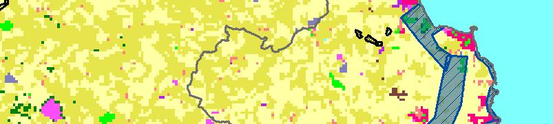
6 Wicklow catchment area in Wicklow 2006 actual map 2026 Scenario Scenario Scenario 3 Residential area development in Wicklow catchment area (W16) in Wicklow Scenario 1: Low growth Scenario 2: Medium growth Scenario 3: High growth Residential areas existing in 2000 Residential areas developed from 2000 to 2026 Catchment boundaries County boundaries 6


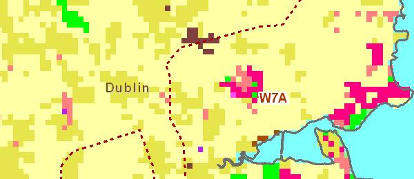


7 Donabate catchment area in Fingal 2006 actual map 2026 Scenario Scenario Scenario 3 Residential area development in Donabate catchment area (currently W4, W7A from 2018) in Fingal Scenario 1: Low growth Scenario 2: Medium growth Scenario 3: High growth Residential areas existing in 2000 Residential areas developed from 2000 to 2026 Catchment boundaries County boundaries 7
8 Residential Area and Planned Increased Plant Capacity Summary MOLAND may be usefully applied in exploring the spatial distribution of land uses under a range of population scenarios. This allows for the proposed increase in waste water treatment capacity for the region to be evaluated in a spatial context under three spatially explicit scenarios of population expansion in the region. 8


9 TRANSPORT NETWORK STUDY Transport Network Urban Environment Project 9


")


10 An Orbital route linking Drogheda, Navan and Naas The impacts on development patterns: a) Without zoning for commercial development at interchanges b) With zoning for commercial development at interchanges Orbital Route Scenario Orbital route added in 2016 Kilcock Maynooth 10


11 Urban Area Development Near Kilcock and Maynooth towns in Kildare County Orbital development without commercial zoning Orbital development with commercial zoning Number of cells Analysing development within a 2km radius of the route Development within 2km buffer No Orbital Orbital No zoning Orbital w ith zoning


12 Summary Orbital route in do minimum scenario caused significant changes in development patterns Orbital route with zoning for commercial development showed even greater impact on development within the transport corridor Urban Environment Project Transport 21 Scenario Transport 21 is the capital investment framework through which the transport system in Ireland will be developed, over the period 2006 to Projects: 7 LUAS projects and 2 Metro lines are being developed upgrade of the Intercity rail network and expanded commuter rail services in Dublin, Cork and Galway completion of the 5 major inter urban roads enhancing bus system capacity by 60% improving safety and security at the regional airports 12
13 Results Employment and Population Outputs in 2026 Total Employment with and without Transport Louth Meath Dublin Kildare Wicklow Total Population with and without Transport 21 With T21 Without T21 With T21 Without T Louth Meath Dublin Kildare Wicklow Summary With Transport 21 fully implemented, we see consolidation of Co. Dublin s population and employment and lower growth in the surrounding counties. With Transport 21 not implemented we see greater growth in the surrounding counties and less growth in Dublin in both population and employment figures. Urban Environment Project 13


 14")

14 ZONING STUDY MOLAND Default Zoning (NHAs, SPAs and SACs) 14


15 Green Infrastructure Zoning Effect of Restricted Development Zoning No special restrictions Scenario 2: 1: Aggressive Moderate zoning 15
16 Conclusion The model has powerful potential in areas such as: Investigating gchanges in land use Analysing route impacts on development Examining Transport infrastructure developments Analysing green zoning corridors MOLAND as a spatial decision support system goes some way to provide decision makers in the area of spatial planning and infrastructure development with a tool that overcomes some of the obstacles encountered in the formulation of regional development policies. Thank You! The Urban Environment Project is generously sponsored by the Irish Environmental Protection Agency as part of the ERTDI programme which is funded through the National Development Plan CD U1 M1 Decision support tools for managing urban environment in Ireland All work undertaken on the MOLAND model, for the Greater Dublin Region is subject to the license conditions of the software developers, Research Institute Knowledge Systems b.v. (RIKS b.v.) and the data set owners, DG JRC under license no. JRC.BWL The authors would like to thank the Dublin and Mid East Regional Authorities, in particular Deirdre Scully and Walter Foley for their cooperation in providing data and the context for the waste water facility case study. We would also like to acknowledge the assistance of Prof. Roger White, Dr. Brendan Williams and the Urban Environment Project team. 16
Applications of the MOLAND model in the Greater Dublin Region
 Urban Environment Project and Applications of the MOLAND model in the Greater Dublin Region Sheila Convery, Dr. Brendan Williams Workshop Integration of Spatial Decision Support Systems and Evidence Based
Po P pulat pula ion Change Chang and Urban Expansion Cormac Walsh W
 Population Change and Urban Expansion Cormac Walsh Introduction This first thematic chapter examines the spatial ilpatterns of urban expansion and population change over the 1990 2006 period. The Dublin
Regional Development Scenario Evaluation through Land Use Modelling and Opportunity Mapping
 Land 2014, 3, 1180-1213; doi:10.3390/land3031180 Article OPEN ACCESS land ISSN 2073-445X www.mdpi.com/journal/land/ Regional Development Scenario Evaluation through Land Use Modelling and Opportunity Mapping
A GIS Tool for Modelling and Visualizing Sustainability Indicators Across Three Regions of Ireland
 International Conference on Whole Life Urban Sustainability and its Assessment M. Horner, C. Hardcastle, A. Price, J. Bebbington (Eds) Glasgow, 2007 A GIS Tool for Modelling and Visualizing Sustainability
The Greater Drogheda Area - Drogheda (Co. Louth), Drogheda South (Co. Meath) & the Meath Coast
, Drogheda South (Co. Meath) & the Meath Coast") Submission to National Planning Framework The Greater Drogheda Area - Drogheda (Co. Louth), Drogheda South (Co. Meath) & the Meath Coast Date: 31st March 2017 From: Cormac Bohan, Proposal: that Drogheda
Submission to National Planning Framework The Greater Drogheda Area - Drogheda (Co. Louth), Drogheda South (Co. Meath) & the Meath Coast Date: 31st March 2017 From: Cormac Bohan, Proposal: that Drogheda
Noise Maps, Report & Statistics, Dublin City Council Noise Mapping Project Roads and Traffic Department
 Noise Maps, Report & Statistics, Dublin City Council Noise Mapping Project Roads and Traffic Department Produced by Traffic Noise & Air Quality Unit November 2007 Contact: brian.mcmanus@dublincity.ie Ph;
Summary and Implications for Policy
 Summary and Implications for Policy 1 Introduction This is the report on a background study for the National Spatial Strategy (NSS) regarding the Irish Rural Structure. The main objective of the study
The Governance of Land Use
 The planning system The Governance of Land Use United Kingdom Levels of government and their responsibilities The United Kingdom is a unitary state with three devolved governments in Northern Ireland,
National Planning Framework Louth County Council Submission
 National Planning Framework 2040 Louth County Council Submission 10 th November 2017 2 Louth County Council Introduction The primacy of the Dublin / Belfast corridor in the urban network on the island
Developing harmonised indicators on urban public transport in Europe
 Developing harmonised indicators on urban public transport in Europe Hugo Poelman European Commission DG Regional and Urban GIS team Regional May 2015 context EU Cohesion European Regional Development
How the science of cities can help European policy makers: new analysis and perspectives
 How the science of cities can help European policy makers: new analysis and perspectives By Lewis Dijkstra, PhD Deputy Head of the Economic Analysis Unit, DG Regional and European Commission Overview Data
The National Spatial Strategy
 Purpose of this Consultation Paper This paper seeks the views of a wide range of bodies, interests and members of the public on the issues which the National Spatial Strategy should address. These views
East Bay BRT. Planning for Bus Rapid Transit
 East Bay BRT Planning for Bus Rapid Transit Regional Vision Draper Prison The Bottleneck is a State-Level issue, Salt Lake County 2050 Population: 1.5M Draper Prison hopefully with some State-Level funding!
Land Use in the context of sustainable, smart and inclusive growth
 Land Use in the context of sustainable, smart and inclusive growth François Salgé Ministry of sustainable development France facilitator EUROGI vice president AFIGéO board member 1 Introduction e-content+
Forecasts for the Reston/Dulles Rail Corridor and Route 28 Corridor 2010 to 2050
 George Mason University Center for Regional Analysis Forecasts for the Reston/Dulles Rail Corridor and Route 28 Corridor 21 to 25 Prepared for the Fairfax County Department of Planning and Zoning Lisa
Spatial Trends of unpaid caregiving in Ireland
 Spatial Trends of unpaid caregiving in Ireland Stamatis Kalogirou 1,*, Ronan Foley 2 1. NCG Affiliate, Thoukididi 20, Drama, 66100, Greece; Tel: +30 6977 476776; Email: skalogirou@gmail.com; Web: http://www.gisc.gr.
Planning and Property Development Strategic Policy Committee February 2019
 An Roinn Pleanála agus Forbartha Maoine Oifigí na Cathrach, An Ché Adhmaid, Baile Átha Cliath 8 Planning and Property Development Department Block 4, Floor 3, Civic Offices, Wood Quay, D8 Planning and
Regional Growth Strategy Work Session Growth Management Policy Board
 Regional Growth Strategy Work Session Growth Management Policy Board September 6, 2018 1 Overview Recap June GMPB work session Objectives and outcomes Regional geographies Growth scenarios Breakout Discussion:
The importance of visioning in urban strategic planning By Peter Robinson. MILE Master Class Urban Strategic Planning March 2016
 The importance of visioning in urban strategic planning By Peter Robinson MILE Master Class Urban Strategic Planning March 2016 Typical strategic planning process Where are we now? Where are we going?
APPENDIX I - AREA PLANS
 ROUTE 37 WEST LAND USE PLAN ROUTE 37 WEST LAND USE PLAN Recent land use decisions and development trends have drawn attention to the land within the Route 37 western by-pass area between Route 50 and
Variation 2: This variation was approved by resolution of Limerick City Council on 23 rd April Limerick City Development Plan
 Variation 2: This variation was approved by resolution of Limerick City Council on 23 rd April 2012 Limerick City Development Plan 2010-2016 Replacement of Chapter 2 - overall strategy to include the preparation
Promoting synergy between airports and cities to achieve sustainable development
 Promoting synergy between airports and cities to achieve sustainable development Content 1. Airports / Aviation 2. Urbanization 3. Shared Threads & Opportunities 4. Synergistic Development for Sustainability
ESPON 2020 Cooperation Programme. Anneloes van Noordt MC-member Belgium
 ESPON 2020 Cooperation Programme Anneloes van Noordt MC-member Belgium Anneloes.vannoordt@vlaanderen.be Outline ESPON 2020 Cooperation Programme Applied Research Targeted Analysis Database & Tools Outreach
Analysis of travel-to-work patterns and the identification and classification of REDZs
 Analysis of travel-to-work patterns and the identification and classification of REDZs Dr David Meredith, Teagasc, Spatial Analysis Unit, Rural Economy Development Programme, Ashtown, Dublin 15. david.meredith@teagasc.ie
GIS Geographical Information Systems. GIS Management
 GIS Geographical Information Systems GIS Management Difficulties on establishing a GIS Funding GIS Determining Project Standards Data Gathering Map Development Recruiting GIS Professionals Educating Staff
Applying GIS to Coastal Management in Cork Harbour: the Corepoint experience
 Applying GIS to Coastal Management in Cork Harbour: the Corepoint experience Kathrin Köpke University College Cork, Ireland Thematic Conference: THE WATERFRONT MANAGEMENT AND GI (IT), 14 th -18 th November
GIS in Community & Regional Planning
 GIS in Community & Regional Planning The The role role of of GIS GIS in in Re-writing the the Zoning Bylaw for for the the City City of of Vernon LandInfo Technologies Presentation Overview The GIS Initiative
Dublin s Place in the Irish and Global Economy Report 1. Prepared for Dublin Regional Authority
 Dublin s Place in the Irish and Global Economy 2012 Report 1 Prepared for Dublin Regional Authority COLLATING AND ASSESSING THE AVAILABILITY AND APPLICABILITY OF SOCIO-ECONOMIC DATA AND INFORMATION RELATING
Regional Spatial & Economic Strategy
 EASTERN & MIDLAND REGIONAL ASSEMBLY Regional Spatial & Economic Strategy Initial Public & Stakeholder Consultation Issues Paper November 2017 Tionól Reigiúnach Oirthir agus Lár-Tíre Eastern and Midland
THE ROLE OF REGIONAL SPATIAL PLANNING IN SUPPORTING LONG-TERM ECONOMIC GROWTH IN NORTHERN IRELAND
 THE ROLE OF REGIONAL SPATIAL PLANNING IN SUPPORTING LONG-TERM ECONOMIC GROWTH IN NORTHERN IRELAND Jenny Pyper Director 6 th Annual ICLRD Conference 20 January 2011 PURPOSE OF REGIONAL PLANNING Framework
Application of Geographic Information Systems for Government School Sites Selection
 Rs. 3000,00 Application of Geographic Information Systems for Government School Sites Selection by K. D. Nethsiri Jayaweera M.Sc. Library - USJP 1111111111111111 210975 2014 210873 Application of Geographic
An online data and consulting resource of THE UNIVERSITY OF TOLEDO THE JACK FORD URBAN AFFAIRS CENTER
 An online data and consulting resource of THE JACK FORD URBAN AFFAIRS CENTER THE CENTER FOR GEOGRAPHIC INFORMATION SCIENCE AND APPLIED GEOGRAPHICS DEPARTMENT OF GEOGRAPHY AND PLANNING THE UNIVERSITY OF
CHAPTER 2. Strategic Context
 CHAPTER 2 Strategic Aim: To facilitate the future development of Cork as a national gateway city within the integrated land use and transportation framework set out in the Cork Area Strategic Plan 2001
EcoServ-GIS. EcoServ GIS Stage I. Why EcoServ GIS? 17/12/2012
 EcoServ-GIS Ecosystem Services Mapping: A Wildlife Trust GIS Toolkit to map ecosystem services at a county scale Dr Jonathan Winn Living Landscape Coordinator Durham Wildlife Trust Dr Chloe Bellamy Ecosystem
Bishkek City Development Agency. Urban Planning Bishkek
 Bishkek City Development Agency Urban Planning Bishkek Bishkek City Development Agency Official name City budget Population Area GRP Import value Export value External trade turnover Foreign direct investments
ENV208/ENV508 Applied GIS. Week 1: What is GIS?
 ENV208/ENV508 Applied GIS Week 1: What is GIS? 1 WHAT IS GIS? A GIS integrates hardware, software, and data for capturing, managing, analyzing, and displaying all forms of geographically referenced information.
King City URA 6D Concept Plan
 King City URA 6D Concept Plan King City s Evolution Among the fastest growing cities 2000 Census 1,949 2010 Census 3,111 60% increase 2016 Census estimate 3,817 23% increase Average annual rate 4.3% Surpassing
São Paulo Metropolis and Macrometropolis - territories and dynamics of a recent urban transition
 São Paulo Metropolis and Macrometropolis - territories and dynamics of a recent urban transition Faculty of Architecture and Urbanism of São Paulo University Prof. Dr. Regina M. Prosperi Meyer WC2 - World
Advancing Geoscientific Capability. Geological Survey of Finland
 Advancing Geoscientific Capability Geological Survey of Finland GTK in brief The Geological Survey of Finland (GTK) is one of the largest European centres of excellence in assessment, research and the
Key Indicators for Territorial Cohesion and Spatial Planning in Preparing Territorial Development Strategies
 ESPON Evidence in a North European Context Challenges and Opportunities for Territorial Development and Cohesion in a North European Macro Region, 10-11 April, 2014, Vilnius, Lithuania Key Indicators for
LABOUR PARTY SUBMISSION TO THE NATIONAL PLANNING FRAMEWORK
 LABOUR PARTY SUBMISSION TO THE NATIONAL PLANNING FRAMEWORK Introduction The Labour Party has previously submitted to the consultation process of the NPF and wishes to expand upon some of the points made
Limerick Chamber s Statement on draft Ireland 2040 National Planning Framework
 Limerick Chamber s Statement on draft Ireland 2040 National Planning Framework 8 th November 2017 Summary of Action Points Strategic Planning for our Regional Cities Our regional cities and strengthening
TABLE OF CONTENTS ARTICLE I. POLK COUNTY COMPREHENSIVE PLAN VOLUME 1. Page CHAPTER 1. GENERAL... A-1
 TABLE OF CONTENTS ARTICLE I. POLK COUNTY COMPREHENSIVE PLAN VOLUME 1 Page CHAPTER 1. GENERAL... A-1 DIVISION 1.100 GENERAL PROVISIONS... A-1 DIVISION 1.200 BASIC PRINCIPLES... A-6 DIVISION 1.300 THE PLANNING
Tackling urban sprawl: towards a compact model of cities? David Ludlow University of the West of England (UWE) 19 June 2014
 19 June 2014") Tackling urban sprawl: towards a compact model of cities? David Ludlow University of the West of England (UWE) 19 June 2014 Impacts on Natural & Protected Areas why sprawl matters? Sprawl creates environmental,
Tackling urban sprawl: towards a compact model of cities? David Ludlow University of the West of England (UWE) 19 June 2014 Impacts on Natural & Protected Areas why sprawl matters? Sprawl creates environmental,
The Role of Urban Planning and Local SDI Development in a Spatially Enabled Government. Faisal Qureishi
 The Role of Urban Planning and Local SDI Development in a Spatially Enabled Government Faisal Qureishi 1 Introduction A continuous increase in world population combined with limited resources has lead
Proposed Scope of Work Village of Farmingdale Downtown Farmingdale BOA Step 2 BOA Nomination Study / Draft Generic Environmental Impact Statement
 Proposed Scope of Work Village of Farmingdale Downtown Farmingdale BOA Step 2 BOA Nomination Study / Draft Generic Environmental Impact Statement The scope of work that follows incorporates and covers
Acceleration into Sprawl: Causes and Potential Policy Responses. Brendan Williams and Patrick Shiels Dublin Institute of Technology
 Acceleration into Sprawl: Causes and Potential Policy Responses Brendan Williams and Patrick Shiels Dublin Institute of Technology 1. Introduction 38 The continuing pace of economic growth in Ireland is
Engagement on Strategies to Overcome Inequality
 Engagement on Strategies to Overcome Inequality Civil Society Engagement with Poverty Julian Sendin 1-2 June 2017 Kievits Kroon Country Estate, Pretoria, South Africa 1. Ndifuna Ukwazi Ndifuna Ukwazi is
Appendix: Development Patterns and Design
 Appendix: Development Patterns and Design Development Patterns Figure 1 lists the amount of land converted from undeveloped to some other form of land for the 13 county and 20 county Atlanta Region. In
Introduction and Project Overview
 Greater New Orleans Regional Land Use Modeling GIS Techniques in a P olitical C ontext Louisiana Remote Sensing and GIS Workshop Wednesday, April 24, 2013 Working Towards a Shared Regional Vision Introduction
Chapter 1 Data Collection
 Chapter 1 Data Collection 1. Climate of Brunei Darussalam and Temburong District Situated at around four degrees north of the Equator, Brunei Darussalam enjoys an equatorial climate with an abundance of
JOURNAL OF IRISH URBAN STUDIES
 i JOURNAL OF IRISH URBAN STUDIES The urbanisation of Irish society has had a profound impact on the character and mix of Irish research. The research agenda now encompasses such diverse issues as the urban
Building the Sustainable Network of Settlements on the Caspian Sea Region of Kazakhstan
 Building the Sustainable Network of Settlements on the Caspian Sea Region of Kazakhstan Introduction The Ecological Zoning and Identification of Ecological Capacity of Natural and Socio- Economic Potential
STILLORGAN QBC LEVEL OF SERVICE ANALYSIS
 4-5th September, STILLORGAN QBC LEVEL OF SERVICE ANALYSIS Mr David O Connor Lecturer Dublin Institute of Technology Mr Philip Kavanagh Graduate Planner Dublin Institute of Technology Abstract Previous
Oman NSDI Business Values and Future Directions. Hassan Alawi Alghazali Acting Director General National Spatial Data Infrastructure
 Oman NSDI Business Values and Future Directions Hassan Alawi Alghazali Acting Director General National Spatial Data Infrastructure Presentation Outline Geospatial Maturity Current Challenges NCSI s Role
MODULE 1 INTRODUCING THE TOWNSHIP RENEWAL CHALLENGE
 MODULE 1 INTRODUCING THE TOWNSHIP RENEWAL CHALLENGE FOCUS OF THE MODULE Township renewal challenges and developmental outcomes covered in this module: Historical origins of townships and the inherited
Updating the Urban Boundary and Functional Classification of New Jersey Roadways using 2010 Census data
 Updating the Urban Boundary and Functional Classification of New Jersey Roadways using 2010 Census data By: Glenn Locke, GISP, PMP 1 GIS-T May, 2013 Presentation Overview Purpose of Project Methodology
DETERMINE OF REGIONAL DEVELOPMENT STRATEGIES IN IZMIR
 Sukran Yalpir Asli Bozdag Saban Inam DETERMINE OF REGIONAL DEVELOPMENT STRATEGIES IN IZMIR Globalization INTRODUCTION Economic pressure cause Economic migration cause cause Spatial organizations Spatial
Vincent Goodstadt. Head of European Affairs METREX European Network
 Vincent Goodstadt Head of European Affairs METREX European Network METREX (Network of 50 European Metropolitan Regions and Areas ) Exchanging Knowledge (e.g. Benchmarking) Climate Change CO2/80/50 Expertise
EXPLORING THE FUTURE WATER INFRASTRUCTURE OF CITIES
 EXPLORING THE FUTURE WATER INFRASTRUCTURE OF CITIES Eng. Arlex Sanchez Torres PhD. R.K. Price PhD. Z. Vojinovic Jan 24 th - 2011 The future of urban water: Solutions for livable and resilient cities SWITCH
Regional Transit Development Plan Strategic Corridors Analysis. Employment Access and Commuting Patterns Analysis. (Draft)
") Regional Transit Development Plan Strategic Corridors Analysis Employment Access and Commuting Patterns Analysis (Draft) April 2010 Contents 1.0 INTRODUCTION... 4 1.1 Overview and Data Sources... 4 1.2
Regional Transit Development Plan Strategic Corridors Analysis Employment Access and Commuting Patterns Analysis (Draft) April 2010 Contents 1.0 INTRODUCTION... 4 1.1 Overview and Data Sources... 4 1.2
Employment sub-centres and the choice of mode of travel to work in. the Dublin region
 Employment sub-centres and the choice of mode of travel to work in the Dublin region Amaya Vega a,b,1, Aisling Reynolds-Feighan b a Department of Economics, National University of Ireland, Galway, Galway,
Forecasts from the Strategy Planning Model
 Forecasts from the Strategy Planning Model Appendix A A12.1 As reported in Chapter 4, we used the Greater Manchester Strategy Planning Model (SPM) to test our long-term transport strategy. A12.2 The origins
The CRP stresses a number of factors that point to both our changing demographics and our future opportunities with recommendations for:
 Plan Overview The CRP represents the first broad planning initiative covering Lake, Porter and LaPorte counties. Unlike previous plans released by NIRPC, which focused primarily on transportation, the
Accessibility as an Instrument in Planning Practice. Derek Halden DHC 2 Dean Path, Edinburgh EH4 3BA
 Accessibility as an Instrument in Planning Practice Derek Halden DHC 2 Dean Path, Edinburgh EH4 3BA derek.halden@dhc1.co.uk www.dhc1.co.uk Theory to practice a starting point Shared goals for access to
LandScan Global Population Database
 LandScan Global Population Database The World s Finest Population Distribution Data Uncommon information. Extraordinary places. LandScan Global Population Database East View Cartographic is now offering
Submission by Monaghan County Council in Response to the Issues and Choices Paper Relating to the National Planning Framework
 Submission by Monaghan County Council in Response to the Issues and Choices Paper Relating to the National Planning Framework March 2017 1 1.0 Introduction 1.1 This submission has been prepared to provide
National Spatial Development Perspective (NSDP) Policy Coordination and Advisory Service
 Policy Coordination and Advisory Service") National Spatial Development Perspective (NSDP) Policy Coordination and Advisory Service 1 BACKGROUND The advances made in the First Decade by far supersede the weaknesses. Yet, if all indicators were
National Spatial Development Perspective (NSDP) Policy Coordination and Advisory Service 1 BACKGROUND The advances made in the First Decade by far supersede the weaknesses. Yet, if all indicators were
PROSPECTS FOR IRISH REGIONS AND COUNTIES
 RESEARCH SERIES NUMBER 70 JANUARY 2018 PROSPECTS FOR IRISH REGIONS AND COUNTIES SCENARIOS AND IMPLICATIONS EDGAR L. W. MORGENROTH EVIDENCE FOR POLICY PROSPECTS FOR IRISH REGIONS AND COUNTIES: SCENARIOS
APPENDIX I: Traffic Forecasting Model and Assumptions
 APPENDIX I: Traffic Forecasting Model and Assumptions Appendix I reports on the assumptions and traffic model specifications that were developed to support the Reaffirmation of the 2040 Long Range Plan.
Compact guides GISCO. Geographic information system of the Commission
 Compact guides GISCO Geographic information system of the Commission What is GISCO? GISCO, the Geographic Information System of the COmmission, is a permanent service of Eurostat that fulfils the requirements
2040 MTP and CTP Socioeconomic Data
 SE Data 6-1 24 MTP and CTP Socioeconomic Data Purpose of Socioeconomic Data The socioeconomic data (SE Data) shows the location of the population and employment, median household income and other demographic
RURAL SETTLEMENT PATTERNS AND ACCESS TO DEVELOPMENT LAND: DEVELOPING THE EVIDENCE BASE
 School of Planning, Architecture and Civil Engineering RURAL SETTLEMENT PATTERNS AND ACCESS TO DEVELOPMENT LAND: DEVELOPING THE EVIDENCE BASE Prepared for Friends of the Earth Northern Ireland 18 th April
Making maps: Traditions and perceptions in Europe. European spatial planning and cartographic representations
 ESPON Create Europe! Making maps: Traditions and perceptions in Europe Dr. Stefanie Dühr University of the West of England, Bristol, UK European spatial planning and cartographic representations Scenarios.
Developed new methodologies for mapping and characterizing suburban sprawl in the Northeastern Forests
 Development of Functional Ecological Indicators of Suburban Sprawl for the Northeastern Forest Landscape Principal Investigator: Austin Troy UVM, Rubenstein School of Environment and Natural Resources
Data driven approaches to Urban Planning Experience from Derry/Londonderry
 Data driven approaches to Urban Planning Experience from Derry/Londonderry Anna Rose RTPI Belfast 11 th of September 1 June 26 07:47AM 2 The value of the City The space of the city is a theatre: playing
Accessibility Instruments in Planning Practice Spatial Network Analysis for Multi-Modal Transport Systems (SNAMUTS): Adelaide
: Adelaide") Accessibility Instruments in Planning Practice Spatial Network Analysis for Multi-Modal Transport Systems (SNAMUTS): Adelaide Prof Carey Curtis, Dr Jan Scheurer, Roger Mellor, Oscar Thomson Curtin University,
Accessibility Instruments in Planning Practice Spatial Network Analysis for Multi-Modal Transport Systems (SNAMUTS): Adelaide Prof Carey Curtis, Dr Jan Scheurer, Roger Mellor, Oscar Thomson Curtin University,
1 Summary Monetary Component Public Purpose Land Provision Introduction Document Structure...
 1 Summary... 1 1.1 Monetary Component... 1 1.2 Public Purpose Land Provision... 1 2 Introduction... 5 2.1 Document Structure... 5 2.2 Planning & Environment Act 1987... 5 2.3 Strategic Planning & Justification...
King Fahd University of Petroleum & Minerals College of Engineering Sciences Civil Engineering Department. Geographical Information Systems(GIS)
") King Fahd University of Petroleum & Minerals College of Engineering Sciences Civil Engineering Department Geographical Information Systems(GIS) Term Project Titled Delineating Potential Area for Locating
King Fahd University of Petroleum & Minerals College of Engineering Sciences Civil Engineering Department Geographical Information Systems(GIS) Term Project Titled Delineating Potential Area for Locating
Urban Spatial Scenario Design Modelling (USSDM) in Dar es Salaam: Background Information
 in Dar es Salaam: Background Information") Urban Spatial Scenario Design Modelling (USSDM) in Dar es Salaam: Background Information Modelling urban settlement dynamics in Dar es Salaam Revision: 2 (July 2013) Prepared by: Katja Buchta TUM team
Urban Spatial Scenario Design Modelling (USSDM) in Dar es Salaam: Background Information Modelling urban settlement dynamics in Dar es Salaam Revision: 2 (July 2013) Prepared by: Katja Buchta TUM team
Accessibility analysis of multimodal transport systems using advanced GIS techniques
 Urban Transport XIII: Urban Transport and the Environment in the 21st Century 655 Accessibility analysis of multimodal transport systems using advanced GIS techniques T. Vorraa Citilabs Regional Director,
MPOs SB 375 LAFCOs SCAG Practices/Experiences And Future Collaborations with LAFCOs
 Connecting LAFCOs and COGs for Mutual Benefits MPOs SB 375 LAFCOs SCAG Practices/Experiences And Future Collaborations with LAFCOs Frank Wen, Manager Research & Analysis Land Use & Environmental Planning
Geographical Information Systems Energy Database Report. WP1 T1.3- Deliverable 1.9
 Geographical Information Systems Energy Database Report WP1 T1.3- Deliverable 1.9 March 2015 1 314164 (ENER/FP7/314164) Project acronym: InSMART Project full title: Integrative Smart City Planning Coordination
The Use of Geographic Information Systems (GIS) by Local Governments. Giving municipal decision-makers the power to make better decisions
 by Local Governments. Giving municipal decision-makers the power to make better decisions") The Use of Geographic Information Systems (GIS) by Local Governments Giving municipal decision-makers the power to make better decisions Case Study: Examples of GIS Usage by Local Governments in North
The Use of Geographic Information Systems (GIS) by Local Governments Giving municipal decision-makers the power to make better decisions Case Study: Examples of GIS Usage by Local Governments in North
LEO Catchment Profile (LCP) Key Data for Enterprise Strategy
 Key Data for Enterprise Strategy") Laois...Portarlington LEO Catchment Profile (LCP) Key Data for Enterprise Strategy Laois Local Enterprise Office Address: Business Support Unit, County Hall, Portlaoise, County Laois Web: https://www.localenterprise.ie/laois/
Laois...Portarlington LEO Catchment Profile (LCP) Key Data for Enterprise Strategy Laois Local Enterprise Office Address: Business Support Unit, County Hall, Portlaoise, County Laois Web: https://www.localenterprise.ie/laois/
CLAREMONT MASTER PLAN 2017: LAND USE COMMUNITY INPUT
 Planning and Development Department 14 North Street Claremont, New Hampshire 03743 Ph: (603) 542-7008 Fax: (603) 542-7033 Email: cityplanner@claremontnh.com www.claremontnh.com CLAREMONT MASTER PLAN 2017:
Urban-Rural spatial classification of Finland
 Urban-Rural spatial classification of Finland Finnish Environment Institute SYKE The geographical information-based area classification system has been created by the Finnish Environment Institute and
Public Transportation Infrastructure Study (PTIS) - 2 nd Technical Advisory Committee Meeting
 - 2 nd Technical Advisory Committee Meeting") Public Transportation Infrastructure Study (PTIS) - 2 nd Technical Advisory Committee Meeting Presentation to: Technical Advisory Committee (TAC) Presented by: and Team July 8th, 2009 Public Transportation
Public Transportation Infrastructure Study (PTIS) - 2 nd Technical Advisory Committee Meeting Presentation to: Technical Advisory Committee (TAC) Presented by: and Team July 8th, 2009 Public Transportation
AUTOMATED METERED WATER CONSUMPTION ANALYSIS
 AUTOMATED METERED WATER CONSUMPTION ANALYSIS Shane Zhong 1, Nick Turich 1, Patrick Hayde 1 1. Treatment and Network Planning, SA Water, Adelaide, SA, Australia ABSTRACT Water utilities collect and store
Coimisiún na Scrúduithe Stáit State Examinations Commission
 2008. M.24 Coimisiún na Scrúduithe Stáit State Examinations Commission LEAVING CERTIFICATE EXAMINATION, 2008 GEOGRAPHY HIGHER LEVEL FRIDAY, 6 JUNE AFTERNOON, 2.00 TO 4.50 Examination Number For the Examiner
Ireland 2040 Our Plan. National Planning Framework
 Ireland 2040 Our Plan National Planning Framework Submission on behalf of Waterford City and County Council Waterford City SE Regional Economic Driver (2040) 1 INTRODUCTION The National Planning Framework
Mapping and Assessment of Ecosystems and their Services
 Mapping and Assessment of Ecosystems and their Services ALTER-Net Conference 2013: Science underpinning the EU 2020 Biodiversity Strategy. April 2013 Gent Joachim MAES 1 This presentation is based on the
GIS Analysis of Crenshaw/LAX Line
 PDD 631 Geographic Information Systems for Public Policy, Planning & Development GIS Analysis of Crenshaw/LAX Line Biying Zhao 6679361256 Professor Barry Waite and Bonnie Shrewsbury May 12 th, 2015 Introduction
Spatial decision making in Armenia based on multidisciplinary environmental research
 EU FP7 EcoArm2ERA Integration into ERA Integration of spatial decision support systems and evidence based modeling in National/Regional Policy applications and regulatory systems: scientific and policy
Local Area Key Issues Paper No. 13: Southern Hinterland townships growth opportunities
 Draft Sunshine Coast Planning Scheme Review of Submissions Local Area Key Issues Paper No. 13: Southern Hinterland townships growth opportunities Key Issue: Growth opportunities for Southern Hinterland
Data Collection. Lecture Notes in Transportation Systems Engineering. Prof. Tom V. Mathew. 1 Overview 1
 Data Collection Lecture Notes in Transportation Systems Engineering Prof. Tom V. Mathew Contents 1 Overview 1 2 Survey design 2 2.1 Information needed................................. 2 2.2 Study area.....................................
IOP Conference Series: Earth and Environmental Science. Related content OPEN ACCESS
 IOP Conference Series: Earth and Environmental Science OPEN ACCESS Using GIS to integrate the analysis of land-use, transportation, and the environment for managing urban growth based on transit oriented
ENVISIONING OUR CITY: 2041 PUBLIC INFORMATION CENTRE #2 November 16, 2017
 ENVISIONING OUR CITY: 2041 PUBLIC INFORMATION CENTRE #2 November 16, 2017 Purpose of the Public Information Centre The City of Brantford is undertaking three studies to guide future development to 2041
Advancing Urban Models in the 21 st Century. Jeff Tayman Lecturer, Dept. of Economics University of California, San Diego
 Advancing Urban Models in the 21 st Century Jeff Tayman Lecturer, Dept. of Economics University of California, San Diego 1 Regional Decision System Better tools Better data Better access Better Decisions
Fig 1. Steps in the EcoValue Project
 Assessing the Social and Economic Value of Ecosystem Services in the Northern Forest Region: A Geographic Information System (GIS) Approach to Landscape Valuation Principal Investigator(s): Dr. Matthew