Advancing Urban Models in the 21 st Century. Jeff Tayman Lecturer, Dept. of Economics University of California, San Diego
|
|
|
- Cecily Shepherd
- 5 years ago
- Views:
Transcription
1 Advancing Urban Models in the 21 st Century Jeff Tayman Lecturer, Dept. of Economics University of California, San Diego 1
2 Regional Decision System Better tools Better data Better access Better Decisions 2
3 Structural Model Classification Economic- Demographic Urban Systems Differ in: Geographic scale Variables considered Statistical tools Policy questions Resource requirements 3

4 Census Blocks Census Tracts Community Plan Areas City Boundaries Council/Supervisorial Districts Zip Codes 33,000 MGRAs 4

5 The Parcel: The Current Frontier 5
6 Presentation Topics History of Urban System Models Model theory and structures Applications and decision making Challenges/Opportunities 6
7 History of Urban Systems Models 7
8 Urban Systems Models 1950s: Emergence Linked land use, residential and non-residential activities and the transportation system Computer capabilities Desire to use scientific methods to assess impact of highways and analyze urban problems 8
9 Urban Systems Models : 90: Maturation and Integration Despite many failed efforts, tremendous knowledge gained about urban spatial patterns Professional consolidation and attempts to integrate broad spectrum of knowledge Modeling approaches Linear statistical techniques (EMPIRIC) Linear program and optimization techniques (POLIS) Spatial interaction gravity formulations 9
10 Urban Systems Models: Widely Used Today Lee s (1973) prognosis was wrong At least 20 centers on 4 continents Most major regional planning/transportation agencies Federal legislation (ISTEA, Clean Air Acts) Policy makers under pressure to address issues related to urban form, land use, and transportation Increased computing power, data availability, and staff/consultant expertise 10
11 Urban Systems Models: Impetus for a New Generation Lack of spatial economic framework Inability to adequately answer new policy questions Excessive art and judgment Not well suited to redevelopment and reuse activities Availability of small area land economic information Enhanced computing/programming infrastructure Modeling community synergies 11
12 Model Theory and Structure: Spatial Interaction Models 12
13 Spatial Interaction Models Forecast in 5-Year 5 time intervals Links employment locations and residential locations Uses commute patterns, travel times, and land use Relies on the spatial interaction gravity model 13
14 Based on: Employment Forecast Locations of existing employment and housing Employment opportunities and attractiveness Transportation accessibility 14
15 Residential Forecast Based on: Distance from employment Residential opportunities and attractiveness Transportation accessibility 15
16 Linking the Land Use and Transportation Models Allocation Model Urban Development Model Allocation Model Employment Forecast Residential Forecast Employment Forecast Residential Forecast Land Use Characteristics Land Use Characteristics Next Increment Transportation Model Highway and Transit Transportation Model Highway and Transit 16
17 Model Theory and Structure: Production, Exchange, Consumption Allocation System (PECAS) 17
18 PECAS: Just Five Choices Where to locate? What to make and what to consume in the process (called the technology to use )? Where to buy what is consumed and where to sell what is made? What type of space (floors pace and buildings) to build? How much space to build? The interactions among these 18
19 PECAS: Components and Treatment of Time model-wide aggregate economic conditions economic changes; migration model-wide aggregate economic conditions activity allocations space development PECAS economic interactions transportation model transportation model changes in transportation year t supply year t+1 19
20 PECAS: Interactions Among Components model-wide aggregate economic conditions Economic Attractions economic changes; migration Development Activity model-wide aggregate economic conditions Activity Totals activity allocations Space Prices space development Space Quantities economic interactions Commodity Flows Generalized Transport Costs transportation model transportation model changes in transportation year t supply year t+1 20


21 Goods, Services, Labour and Space Producing Sectors Consuming Sectors $ $ $ $ $ $ $ $ $ $ $ $ $ $ $ $ $ Economic Flows $ $ $ $ $ $ $ $ $ $ $ $ $ $ $ $ $ $ 21
22 Economic Interactions: Production - Exchange - Consumption buying allocation process total consumption selling allocation process exchange zone exchange zone commodity flows exchange zone total production total production total production 22
23 Economic Interactions: Production - Exchange - Consumption 1: production allocation allocating production activity to zones 2: technology selection allocating production to commodities allocating consumption to commodities 3: selling allocations buying allocations 3-level nested logit model allocating produced commodities to selling locations allocating consumed commodities to buying locations 23
24 Space Development: Simulation of Transitions parcel-by-parcel microsimulation logit models industrial commercial mid density residential more the same no change derelict quantity zoning dictates set of alternatives 24
25 PECAS: Policy Analysis model-wide aggregate economic conditions economic changes; migration Economic Policy model-wide aggregate economic conditions activity allocations space development Land Use Policy Transportation Policy Land Consumption economic interactions Activity Benefits transportation model changes in transportation year t supply year t+1 transportation model Transportation Impacts 25
26 Applications and Decision Making: San Diego County 26
27 San Diego Regional Comprehensive Plan Connecting transportation and land use plans Using transportation and land use plans to guide other plans Making it happen through incentives and collaboration 27

28 SW Riverside County San Diego s s Labor Market 28
29 San Diego Daily Interaction with SW Riverside County Increased Dramatically Interregional Commuting Exchange with San Diego County Imperial Orange Riverside San Bernadino Los Angeles 29
30 Large Daily Flows Across the Border Binational Commuting Exchange with San Diego County U.S. Counties Mexico 30
31 Forecasting Modeling System Spatial Interaction Gravity Models Trip Generation Trip Distribution Mode Choice Trip Assignment 31
32 2030 Regional Futures Existing Smart Percent Policies Growth Difference PPH % Vac. Rate 3.8% 4.9% +28.9% Interregional 100,000 23, % Commute Houses 1,383,800 1,460, % Home Price ($2005) $514,000 $480, % 32


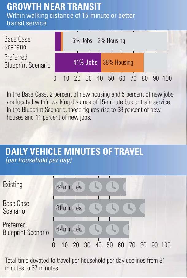
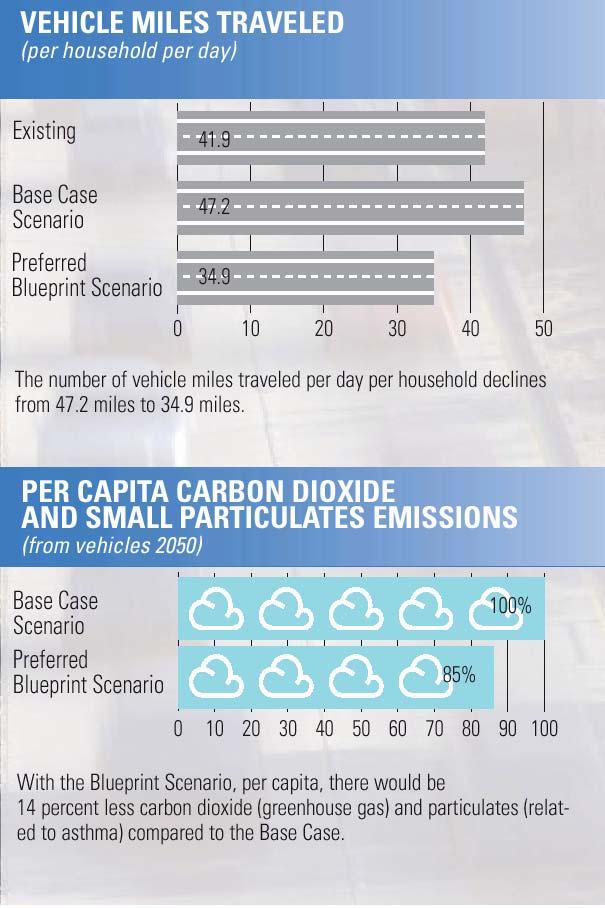
33 Future Units - Existing Policies 33


34 Future Units - Smart Growth 34
 MF SF COMM MF OFF MF")

35 Existing Plan Smart Growth SF MF Vacant (SF) MF SF COMM MF OFF MF Vacant (OS) OFF COMM OS SF SF Vehicle Trips = 3,600 Vehicle Trips = 8,600 35


36 Existing Plan Smart Growth SF MF OS MF COMM School COMM SF SF MF OFF MF SF School Vehicle Trips = 32,200 Vehicle Trips = 26,700 36

37 Economic Benefits of a Highway Project 37
38 Benefits of Smart Growth Reduces sprawl and land consumption Conserves open space and habitat Reduces congestion, trip lengths, travel costs, air pollution, and interregional commuting Provides greater return on investment in transportation, especially transit 38

39 Application and Decision Making: 39

40 Sacramento Blueprint Study 40

41 Sacramento Blueprint Study 41

42 Sacramento Blueprint Study 42

43 Sacramento Blueprint Study 43
44 Sacramento Blueprint Study 44
45 Applications and Decision Making: State of Oregon 45
46 Oregon Bridge Options Study Oregon Bridge Options Study Economic Equity Impacts Broadened Policy Discussion Weight Limited Bridge Cracked Bridge State Bridges Sauvie Island Bridge Cole s Bridge McKenzie/Willamette River Bridges Local Bridges Ford s Bridge * Medium and high crack density 46

47 Oregon Bridge Options Study 47

48 Regional Production Relative to Current Mobility Option 48
49 Willamette Valley Forum Compared land use forecasts under various policies Collaborative visioning HH Growth Compared to Reference Case Many Less Than RC Same as RC Many More Than RC Clark Co. WA Clark Co. WA Clark Co. WA Clark Co. WA Portland Metro Portland Metro Portland Metro Portland Metro Salem-Keizer Salem-Keizer Salem-Keizer Salem-Keizer Corvallis Albany Corvallis Albany Corvallis Albany Corvallis Albany Eugene- Springfield Eugene- Springfield Eugene- Springfield Eugene- Springfield Picture> Picture> Picture> Picture> Highway Expansion High Speed Transit Less Land Supply VMT Tax 49
50 Challenges and Opportunities 50
51 Technical Disclosure rules Efficient management, storage, retrieval, and analysis of large, complex data Data integration More spatial and substantive detail 51

52 Integrating Information Housing Jobs Land Economics Demographics Transportation Travel Behavior Project Costs Income/Wages Performance and System Monitoring Environmental Area Boundaries 52
53 Transparency Information has the power to distort or enhance the reasoning capacity of the public Clear description of methods, data, and assumptions (avoid the black box) Publicly accessible and understandable Outcomes defensible and reasonable 53
54 The Future is Now Economic motives Agent-based modeling Developer, consumer and governmental choice Micro-simulation Synthetic populations, households,and firms 54
55 Reducing Congestion with Ridesharing Vehicle Colors SOV Carpool Bus Truck Existing Conditions Level of Service Average Speed F 19 mph 10 Mile Travel Time 31 Minutes 55

56 Reducing Congestion with Ridesharing Vehicle Colors SOV Carpool Bus Truck Existing Conditions Doubling Carpools Level of Service Average Speed F 19 mph E 38 mph 10 Mile Travel Time 31 Minutes 16 Minutes 56
57 Vehicle Colors SOV Carpool Bus Truck Reducing Congestion with Ridesharing Existing Conditions Doubling Carpools Doubling Carpools & Transit Service Level of Service F E D Average Speed 19 mph 38 mph 55 mph 10 Mile Travel Time 31 Minutes 16 Minutes 11 Minutes 57
58 Conclusions Integrated spatial economic models a reality Are being used in practical policy analysis Big job, but shrinking No longer an unknown Investment that pays off in future Essential: Iterative (Agile) development with initial model running soon The Future Continued leading edge practical studies Continued partnership with academic studies More bringing forward of experience On-going challenges with resource requirements 58
59 Advancing Urban Models in the 21 st Century Jeff Tayman Lecturer, Dept. of Economics University of California, San Diego 59
Dimantha I De Silva (corresponding), HBA Specto Incorporated
, HBA Specto Incorporated") Paper Author (s) Dimantha I De Silva (corresponding), HBA Specto Incorporated (dds@hbaspecto.com) Daniel Flyte, San Diego Association of Governments (SANDAG) (Daniel.Flyte@sandag.org) Matthew Keating,
Paper Author (s) Dimantha I De Silva (corresponding), HBA Specto Incorporated (dds@hbaspecto.com) Daniel Flyte, San Diego Association of Governments (SANDAG) (Daniel.Flyte@sandag.org) Matthew Keating,
Regional Performance Measures
 G Performance Measures Regional Performance Measures Introduction This appendix highlights the performance of the MTP/SCS for 2035. The performance of the Revenue Constrained network also is compared to
Regional Performance Measures
 G Performance Measures Regional Performance Measures Introduction This appendix highlights the performance of the MTP/SCS for 2035. The performance of the Revenue Constrained network also is compared to
Land Use Modeling at ABAG. Mike Reilly October 3, 2011
 Land Use Modeling at ABAG Mike Reilly michaelr@abag.ca.gov October 3, 2011 Overview What and Why Details Integration Use Visualization Questions What is a Land Use Model? Statistical relationships between
An online data and consulting resource of THE UNIVERSITY OF TOLEDO THE JACK FORD URBAN AFFAIRS CENTER
 An online data and consulting resource of THE JACK FORD URBAN AFFAIRS CENTER THE CENTER FOR GEOGRAPHIC INFORMATION SCIENCE AND APPLIED GEOGRAPHICS DEPARTMENT OF GEOGRAPHY AND PLANNING THE UNIVERSITY OF
Geospatial Analysis of Job-Housing Mismatch Using ArcGIS and Python
 Geospatial Analysis of Job-Housing Mismatch Using ArcGIS and Python 2016 ESRI User Conference June 29, 2016 San Diego, CA Jung Seo, Frank Wen, Simon Choi and Tom Vo, Research & Analysis Southern California
Westside Extension Los Angeles, California
 Westside Extension Los Angeles, California Rail~Volution 2010 Portland, Oregon Monica Villalobos AECOM History of Westside Suburban Growth in the Westside (1920 1970 s) LA Centers Concept + Employment
THE FUTURE OF FORECASTING AT METROPOLITAN COUNCIL. CTS Research Conference May 23, 2012
 THE FUTURE OF FORECASTING AT METROPOLITAN COUNCIL CTS Research Conference May 23, 2012 Metropolitan Council forecasts Regional planning agency and MPO for Twin Cities metropolitan area Operates regional
StanCOG Transportation Model Program. General Summary
 StanCOG Transportation Model Program Adopted By the StanCOG Policy Board March 17, 2010 What are Transportation Models? General Summary Transportation Models are technical planning and decision support
MPOs SB 375 LAFCOs SCAG Practices/Experiences And Future Collaborations with LAFCOs
 Connecting LAFCOs and COGs for Mutual Benefits MPOs SB 375 LAFCOs SCAG Practices/Experiences And Future Collaborations with LAFCOs Frank Wen, Manager Research & Analysis Land Use & Environmental Planning
The CRP stresses a number of factors that point to both our changing demographics and our future opportunities with recommendations for:
 Plan Overview The CRP represents the first broad planning initiative covering Lake, Porter and LaPorte counties. Unlike previous plans released by NIRPC, which focused primarily on transportation, the
Smart Growth: Threat to the Quality of Life. Experience
 Smart Growth: Threat to the Quality of Life Presentation by Wendell Cox Wendell Cox Consultancy Visiting Professor Conservatoire National des Arts et Metiers Paris Frontier Centre for Public Policy Winnipeg
New Partners for Smart Growth: Building Safe, Healthy, and Livable Communities Mayor Jay Williams, Youngstown OH
 New Partners for Smart Growth: Building Safe, Healthy, and Livable Communities Mayor Jay Williams, Youngstown OH The City of Youngstown Youngstown State University Urban Strategies Inc. Youngstown needed
HORIZON 2030: Land Use & Transportation November 2005
 PROJECTS Land Use An important component of the Horizon transportation planning process involved reviewing the area s comprehensive land use plans to ensure consistency between them and the longrange transportation
Spatiotemporal Analysis of Commuting Patterns in Southern California Using ACS PUMS, CTPP and LODES
 Spatiotemporal Analysis of Commuting Patterns in Southern California Using ACS PUMS, CTPP and LODES 2017 ACS Data Users Conference May 11-12, 2017 Alexandria, VA Jung Seo, Tom Vo, Frank Wen and Simon Choi
Impact of Metropolitan-level Built Environment on Travel Behavior
 Impact of Metropolitan-level Built Environment on Travel Behavior Arefeh Nasri 1 and Lei Zhang 2,* 1. Graduate Research Assistant; 2. Assistant Professor (*Corresponding Author) Department of Civil and
GIS Analysis of Crenshaw/LAX Line
 PDD 631 Geographic Information Systems for Public Policy, Planning & Development GIS Analysis of Crenshaw/LAX Line Biying Zhao 6679361256 Professor Barry Waite and Bonnie Shrewsbury May 12 th, 2015 Introduction
2040 MTP and CTP Socioeconomic Data
 SE Data 6-1 24 MTP and CTP Socioeconomic Data Purpose of Socioeconomic Data The socioeconomic data (SE Data) shows the location of the population and employment, median household income and other demographic
Metrolinx Transit Accessibility/Connectivity Toolkit
 Metrolinx Transit Accessibility/Connectivity Toolkit Christopher Livett, MSc Transportation Planning Analyst Research and Planning Analytics Tweet about this presentation #TransitGIS OUTLINE 1. Who is
Land Use Impacts of Transportation: A Guidebook. National Cooperative Highway Research Program Transportation Research Board National Research Council
 Land Use Impacts of Transportation: A Guidebook Prepared for National Cooperative Highway Research Program Transportation Research Board National Research Council Project 8-32(3) Integration of Land Use
Developing Built Environment Indicators for Urban Oregon. Dan Rubado, MPH EPHT Epidemiologist Oregon Public Health Division
 Developing Built Environment Indicators for Urban Oregon Dan Rubado, MPH EPHT Epidemiologist Oregon Public Health Division What is the built environment? The built environment encompasses spaces and places
Trip Generation Model Development for Albany
 Trip Generation Model Development for Albany Hui (Clare) Yu Department for Planning and Infrastructure Email: hui.yu@dpi.wa.gov.au and Peter Lawrence Department for Planning and Infrastructure Email: lawrence.peter@dpi.wa.gov.au
The Use of Geographic Information Systems (GIS) by Local Governments. Giving municipal decision-makers the power to make better decisions
 by Local Governments. Giving municipal decision-makers the power to make better decisions") The Use of Geographic Information Systems (GIS) by Local Governments Giving municipal decision-makers the power to make better decisions Case Study: Examples of GIS Usage by Local Governments in North
The Use of Geographic Information Systems (GIS) by Local Governments Giving municipal decision-makers the power to make better decisions Case Study: Examples of GIS Usage by Local Governments in North
2014 Certification Review Regional Data & Modeling
 2014 Certification Review Regional Data & Modeling July 22, 2014 Regional Data Census Program Coordination PAG works with and for member agencies to ensure full participation in all Census Bureau programs
Note on Transportation and Urban Spatial Structure
 Note on Transportation and Urban Spatial Structure 1 By Alain Bertaud, Washington, ABCDE conference, April 2002 Email: duatreb@msn.com Web site: http://alain-bertaud.com/ http://alainbertaud.com/ The physical
Paul Waddell Professor, City and Regional Planning University of California, Berkeley Director, Urban Analy;cs Lab President, UrbanSim Inc.
 2017 Philomathia Forum Urban Data Science and Simula9on For Metropolitan Sustainability Paul Waddell Professor, City and Regional Planning University of California, Berkeley Director, Urban Analy;cs Lab
Regional Growth Strategy Work Session Growth Management Policy Board
 Regional Growth Strategy Work Session Growth Management Policy Board September 6, 2018 1 Overview Recap June GMPB work session Objectives and outcomes Regional geographies Growth scenarios Breakout Discussion:
Spatiotemporal Analysis of Commuting Patterns: Using ArcGIS and Big Data
 Spatiotemporal Analysis of Commuting Patterns: Using ArcGIS and Big Data 2017 ESRI User Conference July 13, 2017 San Diego, VA Jung Seo, Tom Vo, Frank Wen and Simon Choi Research & Analysis Southern California
Growth of Urban Areas. Urban Hierarchies
 Growth of Urban Areas Urban Hierarchies Directions: In your notebook, complete the following on the right: Create a chart to explain and analyze the gravity model, central place theory, bid-rent theory,
Appendixx C Travel Demand Model Development and Forecasting Lubbock Outer Route Study June 2014
 Appendix C Travel Demand Model Development and Forecasting Lubbock Outer Route Study June 2014 CONTENTS List of Figures-... 3 List of Tables... 4 Introduction... 1 Application of the Lubbock Travel Demand
Subject: Note on spatial issues in Urban South Africa From: Alain Bertaud Date: Oct 7, A. Spatial issues
 Page 1 of 6 Subject: Note on spatial issues in Urban South Africa From: Alain Bertaud Date: Oct 7, 2009 A. Spatial issues 1. Spatial issues and the South African economy Spatial concentration of economic
Recovery Renewal Rebuilding
 Recovery Renewal Rebuilding Federal Reserve Foreclosure Series Washington, D.C. October 20, 2008 Mayor Jay Williams, Youngstown OH The City of Youngstown Youngstown State University Urban Strategies Inc.
6 th GLOBAL SUMMIT ON URBAN TOURISM 4 6 December 2017, Kuala Lumpur (Malaysia)
") 6 th GLOBAL SUMMIT ON URBAN TOURISM 4 6 December 2017, Kuala Lumpur (Malaysia) SUMMARY/CONCLUSIONS Esencan TERZIBASOGLU Director Destination Management and Quality eterzibasoglu@unwto.org 6TH GLOBAL SUMMIT
6 th GLOBAL SUMMIT ON URBAN TOURISM 4 6 December 2017, Kuala Lumpur (Malaysia) SUMMARY/CONCLUSIONS Esencan TERZIBASOGLU Director Destination Management and Quality eterzibasoglu@unwto.org 6TH GLOBAL SUMMIT
C) Discuss two factors that are contributing to the rapid geographical shifts in urbanization on a global scale.
 Discuss two factors that are contributing to the rapid geographical shifts in urbanization on a global scale.") AP Human Geography Unit VII. Cities and Urban Land Use Free Response Questions FRQ 1 Rapid urbanization in Least Developed Countries (LDCs) has many profound impacts for the world. Answer the following
AP Human Geography Unit VII. Cities and Urban Land Use Free Response Questions FRQ 1 Rapid urbanization in Least Developed Countries (LDCs) has many profound impacts for the world. Answer the following
The Elusive Connection between Density and Transit Use
 The Elusive Connection between Density and Transit Use Abstract: The connection between density and transportation is heralded by planners, yet results are often elusive. This paper analyzes two regions,
Proposed Scope of Work Village of Farmingdale Downtown Farmingdale BOA Step 2 BOA Nomination Study / Draft Generic Environmental Impact Statement
 Proposed Scope of Work Village of Farmingdale Downtown Farmingdale BOA Step 2 BOA Nomination Study / Draft Generic Environmental Impact Statement The scope of work that follows incorporates and covers
(page 2) So today, I will be describing what we ve been up to for the last ten years, and what I think might lie ahead.
 So today, I will be describing what we ve been up to for the last ten years, and what I think might lie ahead.") Activity-Based Models: 1994-2009 MIT ITS Lab Presentation March 10, 2009 John L Bowman, Ph.D. John_L_Bowman@alum.mit.edu JBowman.net DAY ACTIVITY SCHEDULE APPROACH (page 1) In 1994, Moshe and I began developing
Activity-Based Models: 1994-2009 MIT ITS Lab Presentation March 10, 2009 John L Bowman, Ph.D. John_L_Bowman@alum.mit.edu JBowman.net DAY ACTIVITY SCHEDULE APPROACH (page 1) In 1994, Moshe and I began developing
GIS Geographical Information Systems. GIS Management
 GIS Geographical Information Systems GIS Management Difficulties on establishing a GIS Funding GIS Determining Project Standards Data Gathering Map Development Recruiting GIS Professionals Educating Staff
DEFINING AND MEASURING WORLD-METRO REGIONS FOR INTERNATIONAL COMPARISONS
 DEFINING AND MEASURING WORLD-METRO REGIONS FOR INTERNATIONAL COMPARISONS Mario Piacentini, OECD 27th Scorus Conference, 11-13 August 2010, Latvia Why we need comparable measures of city performance Growing
Geodatabase for Sustainable Urban Development. Presented By Rhonda Maronn Maurice Johns Daniel Ashney Jack Anliker
 Geodatabase for Sustainable Urban Development Presented By Rhonda Maronn Maurice Johns Daniel Ashney Jack Anliker Objective Build a Geodatabase that will enable urban planners to create and assess the
MANAGING TRANSPORTATION & LAND USE INTERACTIONS (PL-58)
") MANAGING TRANSPORTATION & LAND USE INTERACTIONS (PL-58) COURSE OUTLINE DAY ONE 1:30 2:00 p.m. MODULE 1: History and Context Understand history and foundation for transportation and land use planning today
MANAGING TRANSPORTATION & LAND USE INTERACTIONS (PL-58) COURSE OUTLINE DAY ONE 1:30 2:00 p.m. MODULE 1: History and Context Understand history and foundation for transportation and land use planning today
Regional Architectures: Institutions of the Metropolis. Content
 Regional Architectures: Institutions of the Metropolis Day 4 11.953 Content Wrap-up from Last Lecture The Future of Travel Demand Modeling Integrated LUT Models Regional Architectures Governing Systems
Economic and Social Urban Indicators: A Spatial Decision Support System for Chicago Area Transportation Planning
 Economic and Social Urban Indicators: A Spatial Decision Support System for Chicago Area Transportation Planning Piyushimita Thakuriah (Vonu), P.S. Sriraj, Paul Metaxatos, Inshu Minocha & Tanushri Swarup
ADDRESSING TITLE VI AND ENVIRONMENTAL JUSTICE IN LONG-RANGE TRANSPORTATION PLANS
 ADDRESSING TITLE VI AND ENVIRONMENTAL JUSTICE IN LONG-RANGE TRANSPORTATION PLANS Activities from the National Capital Region Transportation Planning Board Sergio Ritacco Transportation Planner 2017 Association
PIBC Annual Conference, 2016
 Land Use Quantified PIBC Annual Conference, 2016 A collaboration between: Christy & Associated Planning Consultants The Sustainable Transportation Partnership of the Central Okanagan Hazel Christy Rafael
Speakers: Jeff Price, Federal Transit Administration Linda Young, Center for Neighborhood Technology Sofia Becker, Center for Neighborhood Technology
 Speakers: Jeff Price, Federal Transit Administration Linda Young, Center for Neighborhood Technology Sofia Becker, Center for Neighborhood Technology Peter Haas, Center for Neighborhood Technology Craig
Simulating Mobility in Cities: A System Dynamics Approach to Explore Feedback Structures in Transportation Modelling
 Simulating Mobility in Cities: A System Dynamics Approach to Explore Feedback Structures in Transportation Modelling Dipl.-Ing. Alexander Moser [amoser@student.tugraz.at] IVT Tagung 2013 - Kloster Kappel
East Bay BRT. Planning for Bus Rapid Transit
 East Bay BRT Planning for Bus Rapid Transit Regional Vision Draper Prison The Bottleneck is a State-Level issue, Salt Lake County 2050 Population: 1.5M Draper Prison hopefully with some State-Level funding!
Changes in the Spatial Distribution of Mobile Source Emissions due to the Interactions between Land-use and Regional Transportation Systems
 Changes in the Spatial Distribution of Mobile Source Emissions due to the Interactions between Land-use and Regional Transportation Systems A Framework for Analysis Urban Transportation Center University
The effects of impact fees on urban form and congestion in Florida
 The effects of impact fees on urban form and congestion in Florida Principal Investigators: Andres G. Blanco Ruth Steiner Presenters: Hyungchul Chung Jeongseob Kim Urban and Regional Planning Contents
Land Use in the context of sustainable, smart and inclusive growth
 Land Use in the context of sustainable, smart and inclusive growth François Salgé Ministry of sustainable development France facilitator EUROGI vice president AFIGéO board member 1 Introduction e-content+
ACCESSIBILITY TO SERVICES IN REGIONS AND CITIES: MEASURES AND POLICIES NOTE FOR THE WPTI WORKSHOP, 18 JUNE 2013
 ACCESSIBILITY TO SERVICES IN REGIONS AND CITIES: MEASURES AND POLICIES NOTE FOR THE WPTI WORKSHOP, 18 JUNE 2013 1. Significant differences in the access to basic and advanced services, such as transport,
accessibility accessibility by-pass bid-rent curve bridging point administrative centre How easy or difficult a place is to reach.
 accessibility accessibility How easy or difficult a place is to reach. How easy or difficult it is to enter a building. administrative centre bid-rent curve The function of a town which is a centre for
TOWARDS STRATEGIC SPATIAL PLANNING IN JAMAICA: THE NATIONAL SPATIAL PLAN
 TOWARDS STRATEGIC SPATIAL PLANNING IN JAMAICA: THE NATIONAL SPATIAL PLAN JIEP 5th Biennial Conference on the Environment: Balancing National Development and Environmental Protection June 6, 2011 Jamaica
OREGON POPULATION FORECAST PROGRAM
 OREGON POPULATION FORECAST PROGRAM PROGRAM OVERVIEW BACKGROUND Beginning in 1973 with the passage of Senate Bill (SB) 100, Oregon s growth management system has relied on population forecasts as the primary
Decentralisation and its efficiency implications in suburban public transport
 Decentralisation and its efficiency implications in suburban public transport Daniel Hörcher 1, Woubit Seifu 2, Bruno De Borger 2, and Daniel J. Graham 1 1 Imperial College London. South Kensington Campus,
BROOKINGS May
 Appendix 1. Technical Methodology This study combines detailed data on transit systems, demographics, and employment to determine the accessibility of jobs via transit within and across the country s 100
November 29, World Urban Forum 6. Prosperity of Cities: Balancing Ecology, Economy and Equity. Concept Note
 November 29, 2010 World Urban Forum 6 Prosperity of Cities: Balancing Ecology, Economy and Equity Concept Note 1 CONTENT Thematic Continuity Conceptualizing the Theme The 6 Domains of Prosperity The WUF
Density and Walkable Communities
 Density and Walkable Communities Reid Ewing Professor & Chair City and Metropolitan Planning University of Utah ewing@arch.utah.edu Department of City & Metropolitan Planning, University of Utah MRC Research
Population and Employment Forecast
 Population and Employment Forecast How Do We Get the Numbers? Thurston Regional Planning Council Technical Brief Updated July 2012 We plan for forecast growth in Population and Employment, but where do
MOR CO Analysis of future residential and mobility costs for private households in Munich Region
 MOR CO Analysis of future residential and mobility costs for private households in Munich Region The amount of the household budget spent on mobility is rising dramatically. While residential costs can
Land Cover Classification Mapping & its uses for Planning
 Land Cover Classification Mapping & its uses for Planning What is Land Cover Classification Mapping? Examples of an actual product Why use Land Cover Classification Mapping for planning? Possible uses
Environmental Analysis, Chapter 4 Consequences, and Mitigation
 Environmental Analysis, Chapter 4 4.17 Environmental Justice This section summarizes the potential impacts described in Chapter 3, Transportation Impacts and Mitigation, and other sections of Chapter 4,
Assessment of Sustainable Land Use within the Town Planning Process Experiences with a Multi Criteria Approach (MCA)
") Assessment of Sustainable Land Use within the Town Planning Process Experiences with a Multi Criteria Approach (MCA) Dipl.-Geogr. Sophie Schetke Dipl.-Ing. Benedikt Frielinghaus, University of Bonn, Germany
Assessment of Sustainable Land Use within the Town Planning Process Experiences with a Multi Criteria Approach (MCA) Dipl.-Geogr. Sophie Schetke Dipl.-Ing. Benedikt Frielinghaus, University of Bonn, Germany
Johns Hopkins University Fall APPLIED ECONOMICS Regional Economics
 Johns Hopkins University Fall 2017 Applied Economics Sally Kwak APPLIED ECONOMICS 440.666 Regional Economics In this course, we will develop a coherent framework of theories and models in the field of
Changes in Transportation Infrastructure and Commuting Patterns in U.S. Metropolitan Areas,
 Changes in Transportation Infrastructure and Commuting Patterns in U.S. Metropolitan Areas, 1960-2000 Nathaniel Baum-Snow Department of Economics Box B Brown University Providence, RI 02912 Nathaniel_Baum-Snow@brown.edu
New Frameworks for Urban Sustainability Assessments: Linking Complexity, Information and Policy
 New Frameworks for Urban Sustainability Assessments: Linking Complexity, Information and Policy Moira L. Zellner 1, Thomas L. Theis 2 1 University of Illinois at Chicago, Urban Planning and Policy Program
CIV3703 Transport Engineering. Module 2 Transport Modelling
 CIV3703 Transport Engineering Module Transport Modelling Objectives Upon successful completion of this module you should be able to: carry out trip generation calculations using linear regression and category
INTRODUCTION TO TRANSPORTATION SYSTEMS
 INTRODUCTION TO TRANSPORTATION SYSTEMS Lectures 5/6: Modeling/Equilibrium/Demand 1 OUTLINE 1. Conceptual view of TSA 2. Models: different roles and different types 3. Equilibrium 4. Demand Modeling References:
Jobs-Housing Fit: Linking Housing Affordability and Local Wages
 Jobs-Housing Fit: Linking Housing Affordability and Local Wages Alex Karner, PhD Assistant Professor School of City and Regional Planning Georgia Institute of Technology Chris Benner, PhD Dorothy E. Everett
The role of community in urban regeneration: mixed use areas approach in USA
 The role of community in urban regeneration: mixed use areas approach in USA Outline 1. Thesis 2. Main topics 3. Urban regeneration and community 4. Community involvement methods 5. Policies: EU vs USA
Urbanization and Sustainable Development of Cities: A Ready Engine to Promote Economic Growth and Cooperation
 Urbanization and Sustainable Development of Cities: A Ready Engine to Promote Economic Growth and Cooperation Wan Portia Hamzah Institute of Strategic and International Studies (ISIS) Malaysia 10 September
SPIMA Spatial dynamics and strategic planning in metropolitan areas
 SPIMA Spatial dynamics and strategic planning in metropolitan areas Dr. Vanya Simeonova Wageningen Environmental Research Wageningen University and research, The Netherlands Key outcomes: SPIMA Framework
Economic Activity Economic A ctivity
 5 Economic Economic Activity Activity ECONOMIC ACTIVITY 5.1 EMPLOYMENT... 5-7 5.1.1 OBJECTIVE... 5-7 5.1.2 POLICIES... 5-7 5.2 PROTECTING THE AREA OF EMPLOYMENT... 5-9 5.2.1 OBJECTIVE... 5-9 5.2.2 POLICIES...
Leveraging Urban Mobility Strategies to Improve Accessibility and Productivity of Cities
 Leveraging Urban Mobility Strategies to Improve Accessibility and Productivity of Cities Aiga Stokenberga World Bank GPSC African Regional Workshop May 15, 2018 Roadmap 1. Africa s urbanization and its
Can Public Transport Infrastructure Relieve Spatial Mismatch?
 Can Public Transport Infrastructure Relieve Spatial Mismatch? Evidence from Recent Light Rail Extensions Kilian Heilmann University of California San Diego April 20, 2015 Motivation Paradox: Even though
National Planning Framework Louth County Council Submission
 National Planning Framework 2040 Louth County Council Submission 10 th November 2017 2 Louth County Council Introduction The primacy of the Dublin / Belfast corridor in the urban network on the island
Employment Decentralization and Commuting in U.S. Metropolitan Areas. Symposium on the Work of Leon Moses
 Employment Decentralization and Commuting in U.S. Metropolitan Areas Alex Anas Professor of Economics University at Buffalo Symposium on the Work of Leon Moses February 7, 2014 9:30-11:15am, and 2:30-4:30pm
Data driven approaches to Urban Planning Experience from Derry/Londonderry
 Data driven approaches to Urban Planning Experience from Derry/Londonderry Anna Rose RTPI Belfast 11 th of September 1 June 26 07:47AM 2 The value of the City The space of the city is a theatre: playing
Overview of Improved Data and Tools for Integrated Land Use-Transportation Planning in California Caltrans Planning Horizons program November 7, 2012
 Overview of Improved Data and Tools for Integrated Land Use-Transportation Planning in California Caltrans Planning Horizons program November 7, 2012 Presentation Outline Part 1. Overview - Terry Parker,
Council Workshop on Neighbourhoods Thursday, October 4 th, :00 to 4:00 p.m. Burlington Performing Arts Centre
 Council Workshop on Neighbourhoods Thursday, October 4 th, 2012 1:00 to 4:00 p.m. Burlington Performing Arts Centre Agenda Introductions Warm-Up Exercise Presentation Exercise Neighbourhood Planning Break
The National Spatial Strategy
 Purpose of this Consultation Paper This paper seeks the views of a wide range of bodies, interests and members of the public on the issues which the National Spatial Strategy should address. These views
Guidelines on Using California Land Use/Transportation Planning Tools
 Guidelines on Using California Land Use/Transportation Planning Tools 1. Selecting Ds Analysis Modules Appropriate to a Region In almost all cases, the appropriate Ds Analysis Module to use for analysis
Regional Snapshot Series: Transportation and Transit. Commuting and Places of Work in the Fraser Valley Regional District
 Regional Snapshot Series: Transportation and Transit Commuting and Places of Work in the Fraser Valley Regional District TABLE OF CONTENTS Complete Communities Daily Trips Live/Work Ratio Commuting Local
STATE GEOGRAPHIC INFORMATION DATABASE
 STATE GEOGRAPHIC INFORMATION DATABASE Data Information and Knowledge Management STATE GEOGRAPHIC INFORMATION DATABASE EXECUTIVE SUMMARY Utah has developed one of the most comprehensive statewide GIS resources
Alternatives Analysis Report
 1.0 PURPOSE AND NEED The Southern California Association of Governments (SCAG), in coordination with the Los Angeles County Metropolitan Transportation Authority (Metro) and the Orange County Transportation
Varying Influences of the Built Environment on Household Travel in Fifteen Diverse Regions of the United states
 Varying Influences of the Built Environment on Household Travel in Fifteen Diverse Regions of the United states Ewing, R., G. Tian, J.P. Goates, M. Zhang, M. Greenwald, Lane Council of Governments, A.
Port Cities Conference: How Regional Planning can Help Support a Competitive Port. Christina DeMarco Metro Vancouver
 Port Cities Conference: How Regional Planning can Help Support a Competitive Port Christina DeMarco Metro Vancouver June 12. 2008 Metro Vancouver Regional Growth Management Three ways to help support the
A Comprehensive Method for Identifying Optimal Areas for Supermarket Development. TRF Policy Solutions April 28, 2011
 A Comprehensive Method for Identifying Optimal Areas for Supermarket Development TRF Policy Solutions April 28, 2011 Profile of TRF The Reinvestment Fund builds wealth and opportunity for lowwealth communities
Third Cohesion report February 2004
 February 2004 A new partnership for cohesion Convergence, Competitiveness and Co-operation METREX meeting S. Sebastian, Luisa Sanches DG REGIO The 3rd CR structure 1. Analysis of situation and trends in
FOURTH URBAN RESEARCH SYMPOSIUM URBAN LAND USE AND LAND MARKETS. WASHINGTON D.C., U.S.A. May 2007
 FOURTH URBAN RESEARCH SYMPOSIUM URBAN LAND USE AND LAND MARKETS WASHINGTON D.C., U.S.A. May 2007 METROPOLITAN MONTEVIDEO: LAND USES AND URBAN LAND MARKET CLUSTER 1 ISABEL VIANA URUGUAY METROPOLITAN MONTEVIDEO
NEW YORK AND CONNECTICUT SUSTAINABLE COMMUNITIES. Fair Housing & Equity Assessment & Regional Planning Enhancement
 NEW YORK AND CONNECTICUT SUSTAINABLE COMMUNITIES Fair Housing & Equity Assessment & Regional Planning Enhancement November 19, 2013 White Plains Public Library Federal grant to improve regional planning
3D - Boulder Valley Comprehensive Plan. Lesli Ellis Comprehensive Planning Manager City of Boulder
 3D - Boulder Valley Comprehensive Plan Lesli Ellis Comprehensive Planning Manager City of Boulder Presentation Boulder s use of 3D GIS and other tools in Comprehensive Planning (e.g., story maps, CityEngine,
Commuting Technologies, City Structure and Urban Inequality: Evidence from Bogotá s TransMilenio
 Commuting Technologies, City Structure and Urban Inequality: Evidence from Bogotá s TransMilenio Nick Tsivanidis University of Chicago Booth School of Business IGC Cities January 28, 206 This Paper Rapidly
Decarbonising Road Freight EXPERT WORKSHOP June 2018
 MASS-GT An empirical agent-based model for urban road freight transport dr.ir. Michiel de Bok, prof.dr.ir. Lorí Tavasszy Decarbonising Road Freight EXPERT WORKSHOP 28-29 June 2018 OECD Boulogne Urban freight
Is better access key to inclusive cities? Making urban areas accessible
 10 11 GLOBAL DEBATES Is better access key to inclusive cities? Making urban areas accessible by Jeff Gutman and Nirav Patel Design and layout: 10 Is better access key to inclusive cities? Making urban
CLAREMONT MASTER PLAN 2017: LAND USE COMMUNITY INPUT
 Planning and Development Department 14 North Street Claremont, New Hampshire 03743 Ph: (603) 542-7008 Fax: (603) 542-7033 Email: cityplanner@claremontnh.com www.claremontnh.com CLAREMONT MASTER PLAN 2017:
Impacts of Transit Rail Lines on Property Values
 Impacts of Transit Rail Lines on Property Values Rail~Volution 2007 Introduction The Question Research Tools Methodology Examples Results Question Won t transit in my backyard hurt my property value?
King City URA 6D Concept Plan
 King City URA 6D Concept Plan King City s Evolution Among the fastest growing cities 2000 Census 1,949 2010 Census 3,111 60% increase 2016 Census estimate 3,817 23% increase Average annual rate 4.3% Surpassing
APPLICATIONS OF EARTHQUAKE HAZARD MAPS TO LAND-USE AND EMERGENCY PLANNING EXAMPLES FROM THE PORTLAND AREA
 APPLICATIONS OF EARTHQUAKE HAZARD MAPS TO LAND-USE AND EMERGENCY PLANNING EXAMPLES FROM THE PORTLAND AREA O. Gerald Uba Metro, Portland, Oregon OVERVIEW The extent to which we understand "below ground"