EU HOs in Mediterranean and Black Sea (MBS) CROATIA FRANCE GREECE ITALY MALTA X SLOVENIA X SPAIN ROMANIA X
|
|
|
- Joshua Webster
- 6 years ago
- Views:
Transcription

1 EU HOs in Mediterranean and Black Sea (MBS) CROATIA FRANCE GREECE ITALY MALTA X SLOVENIA X SPAIN ROMANIA X

2 Croatia Current status of hydrographic survey in acc. IHO C-55 pub. criteria
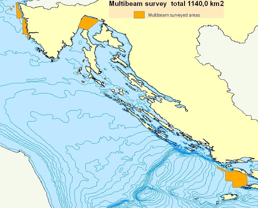
3 Croatia


4 Croatia by LIDAR The area to be covered is about km 2 calculated to 20 m C.L.


5 Possible joint /cooperation survey in Adriatic Sea
 480 10 1170 To be surveyed (km²) 530 1750 1230 30 to 50m (MBES) 50 340 0 to 30-40m (Lidar) Running 2018 970 running 2018 Corsica 30 to 50m (MBES) 620running 2018 Total")
6 France Total Area = 2900 Km 2 Regions to be surveyed Occitanie Provence-Alpes-Côte d Azur (PACA) Area of interest (depths) 0 to 10m (Lidar) 10 to 50m (MBES) 0 to 30m (Lidar) Already surveyed (km²) To be surveyed (km²) to 50m (MBES) to 30-40m (Lidar) Running running 2018 Corsica 30 to 50m (MBES) 620running 2018 Total 2900

7 Greece Greek Islands Archipelagos


8 Greece Total Area = 3835 Km 2
 48% to be surveyed with modern techniques (between")
9 Italy Sea Area: km2 Coast line lenght: km Explored area: 2% to be surveyed (before 1920) 48% to be surveyed with modern techniques (between ) 50% surveyed with modern techniques (after 1970 Low density)
10 Ligurian Sea (0-50m) Italy Total Area = Km 2 Thyrrenian Sea (0-50m) Adriatic Sea (0-50m) West Sardinian Sea (0-50m) COVERAGE AREA LIGURIAN SEA TIRRHENIAN SEA Depth (m) Area of Interest KMQ Surveyed Multibeam KMQ To be surveyed KMQ To be surveyed % Ionian Sea (0-50m) ADRIATIC SEA IONIAN SEA STRAIT OF SICILIA WEST MEDITERRAN EAN (SARDEGNA)

11 Romania Enhance data density of 0-15m water depth region, but most probable it has to take into account an onshore buffer zone for Lidar surveying. GIS technology is used and the area to be covered is about 1500 km 2.

12 Slovenia All Slovenian waters can be considered coastal. The area is rather small and shallow (average 17m).For this reason all the area should be covered with high resolution data. A 2 km buffer from coastline should be considered as priority area to be surveyed with high resolution data: approximately 92 km 2.
13 INTERREG PROJECT IAGvdlYYqTgNK3mgI&ll= %2C &z=7

14 INTERREG VA Italy-Croatia Coastal Mapping and Data in the Programme Coastal mapping activities are included in 2 different priority axis of the Programme: - PRIORITY AXIS 2 - Safety and resilience - has 2 specific objectives with a coastal mapping and data dimension: Specific Objective Improve the climate change monitoring and planning of adaptation measures tackling specific effects, in the cooperation area - will support actions: - Aimed at improving the knowledge base, data and monitoring systems supporting adaptation capacity; - Actions aimed at increasing the capacity for planning of adaptation measures These actions could consist in setting up of common/ integrated/ harmonized monitoring and observing systems, model, spatial data infrastructures to improve the assessment and forecast capabilities, support the planning and design phase, promote the resilience to climate change Specific Objective Increase the safety of the Programme area from natural and man-made disaster - will support activities aimed at: - Improving monitoring of risks - Increasing the management capacity of / prompt response to disasters

15 INTERREG VA Italy-France Marittimo MARITTIMO Coastal Mapping and Data in the Programme Priority Axis 2 - Protection and valorization of natural and cultural resources and risk management - Improve the capacity of public institutions to anticipate and manage, jointly, certain specific risks arising from climate change: hydrological risk, particularly related to flooding, coastal erosion, fires.

16 INTERREG VB Adriatic and Ionian Sea Activities related to coastal data and mapping 2 other priorities of the Programme need coastal data and mapping in order to be implemented: Priority Axis 1: Innovative and Smart Region includes maritime technologies and covers activities such as seabed mining which need coastal and seabed mapping. Priority Axis 3: Connected Region has a large maritime dimension, maritime transport having an important share in the strategy of the Programme.

17 INTERREG VB Mediterranean Activities related to coastal data and mapping The 3 other priorities of the programme will need coastal data and mapping in order to reach some of their objectives: INTERREG VB Mediterranean
18 Maritime Spatial Planning (MSP)
19 BLACK SEA

20 EASTERN MED INTERREG

21 WESTERN MED

22 ADRION.HINTECOS (HUMAN IMPACTS ON SEA-FLOOR INTEGRITY AND ECOSYSTEMS IN THE ADRIATIC-IONIAN SEAS) Submission by the end of March

23 INTERREG V-A Italy - France (Maritime) IMPACT Project Port Impact on Protected Marine Areas: Cooperative Cross-Border Actions
 Status")

24 AMARe (ACTION FOR MARINE PROTECTED AREAS) Status Ongoing Completion Year 2019 COUNTRIES France Greece Italy Malta Spain
Mediterranean Sea and Territorial Development, Opportunities and Risks
 EESC Hearing Towards an EU Macro-Regional Strategy for the Mediterranean Mediterranean Sea and Territorial Development, Opportunities and Risks Michaela Gensheimer Structure of Intervention Part I: What
Mediteranean sea issues in the view of ESPON ESaTDOR project and Marine Spatial Planning in Slovenia
 DIREKTORAT ZA PROSTOR, GRADITEV IN STANOVANJA Mediteranean sea issues in the view of ESPON ESaTDOR project and Marine Spatial Planning in Slovenia BlueMed meeting of stakeholders on a micro-regional level
Coastal Mapping Follow on? Bruno Frachon Corine Lochet Gaël Morvan
 Coastal Mapping Follow on? Bruno Frachon Corine Lochet Gaël Morvan Shared objectives; IHO DG MARE CPMR Development of a Joint European Coastal Mapping Programme (JECMaP) within the IHO EU network with
Seabed knowledge In support of UN SDGs
 Seabed knowledge In support of UN SDGs Evert Flier Fiskerifaglig forum 2. november 2017 Hydrography & small scale fishing Hydrography in Transition Serving the Maritime Community Hydrography in Transition
R E P U B L I C O F C Y P R U S. NATIONAL REPORT OF CYPRUS TO THE 19 th MEDITERRANEAN AND BLACK SEAS HYDROGRAPHIC COMMISSION (MBSHC)
") R E P U B L I C O F C Y P R U S NATIONAL REPORT OF CYPRUS TO THE 19 th MEDITERRANEAN AND BLACK SEAS HYDROGRAPHIC COMMISSION (MBSHC) BATUMI MEETING 30 JUNE TO 02 JULY 2015 NATIONAL REPORT OF CYPRUS TO THE
R E P U B L I C O F C Y P R U S NATIONAL REPORT OF CYPRUS TO THE 19 th MEDITERRANEAN AND BLACK SEAS HYDROGRAPHIC COMMISSION (MBSHC) BATUMI MEETING 30 JUNE TO 02 JULY 2015 NATIONAL REPORT OF CYPRUS TO THE
Coastal data for Integrated Maritime Policies
 Coastal data for Integrated Maritime Policies LOCHET Corine Shom Name of presentation Protection against erosion and marine flood Name presenter Link between different data scales and Name of presentation
R E P U B L I C O F C Y P R U S NATIONAL REPORT OF CYPRUS TO THE MEDITERRANEAN AND BLACK SEAS HYDROGRAPHIC COMMISSION (MBSHC)
") R E P U B L I C O F C Y P R U S NATIONAL REPORT OF CYPRUS TO THE MEDITERRANEAN AND BLACK SEAS HYDROGRAPHIC COMMISSION (MBSHC) ISTANBUL MEETING 25-27 SEPTEMBER 2013 NATIONAL REPORT OF CYPRUS TO THE MEDITERRANEAN
R E P U B L I C O F C Y P R U S NATIONAL REPORT OF CYPRUS TO THE MEDITERRANEAN AND BLACK SEAS HYDROGRAPHIC COMMISSION (MBSHC) ISTANBUL MEETING 25-27 SEPTEMBER 2013 NATIONAL REPORT OF CYPRUS TO THE MEDITERRANEAN
EUSAIR on sea topics from Slovenian perspective
 MINISTRY OF FOREIGN AFFAIRS REPUBLIC OF SLOVENIA EUSAIR on sea topics from Slovenian perspective Mag. Andreja Jerina National Coordinator 4 EU MRS: 270 millions of population 19 MS 12 non MS Sea basin
Aquaculture Spatial Planning: The case of Greece
 Aquaculture Spatial Planning: The case of Greece Nikos Anagnopoulos Panhellenic Association for Small-Medium sized Aquaculture Enterprises Panhellenic Association for Small-Medium sized Aquaculture Enterprises
Interest for HOs to cooperate with EU Commission:
 Plenary session of the European IHO Network Working Group (IENWG) Interest for HOs to cooperate with EU Commission: Why HOs and the EU Commission need a closer cooperation Rear Admiral (N) Luigi SINAPI
Blue Growth: The Adriatic and Ionian Region
 Blue Growth: The Adriatic and Ionian Region Maritime Clusters: types of support and areas for cooperation AQUAE VENICE 2015 EXPO Matteo Bocci, Ecorys Venice, 28 th September 2015 Structure of this intervention
MODELS AND TOOLS FOR GOVERNANCE OF
 Working Papers Collection No. 1/2015 MODELS AND TOOLS FOR GOVERNANCE OF THE ADRIATIC AND IONIAN SEAS www.unimc.it/maremap NATIONAL POLITICS AND EU POLITICS: THE MARITIME SPATIAL PLANNING AND INTEGRATED
Agenzia per la coesione Territoriale. Obstacles on maritime borders
 7th MEETING OF THE WORKING GROUP ON INNOVATIVE SOLUTIONS TO CROSSBORDER OBSTACLES Obstacles on maritime borders 3rd May 2018 French Permanent Representation to the EU Place de Louvain 14, Brussels Viviana
A donor partner view. Olaf Magnus Østensen. 'Modernization of spatial data infrastructure to reduce risks and impacts of floods'
 A donor partner view Olaf Magnus Østensen 'Modernization of spatial data infrastructure to reduce risks and impacts of floods' About the EEA Grants programme http://eeagrants.org/ Beneficiary country Donor
ADRIPLAN Project Prof. Francesco Musco, IUAV University of Venice
 ADRIPLAN Project Prof. Francesco Musco, IUAV University of Venice msp@iuav.it Riga, Baltic MSP Forum, 17/18 June 2014 Outline The ADRIPLAN Project (DG MARE) Methodological insights Planning Design & interaction
4 th IHO-HSSC Meeting IHB, Taunton, September Report to HSSC-4 by the Correspondence Group on Definition and Length of Coastline
 HSSC4-03C rev1 4 th IHO-HSSC Meeting IHB, Taunton, 25-28 September 2012 Report to HSSC-4 by the Correspondence Group on Definition and Length of Coastline Submitted by: France Executive Summary: This paper
MR. George ALEXAKIS, parallel session 3. "Mediterranean Sea Region. laying the conditions. for sustainable growth and jobs"
 parallel session 3 "Mediterranean Sea Region laying the conditions for sustainable growth and jobs" MR. George ALEXAKIS, elected Regional Councillor of Crete, Greece and representative of Crete in CRPM.
ADRIPLAN: an EU funded pilot project on MSP in the Adriatic Ionian Region Pierpaolo Campostrini CORILA and CNR-ISMAR
 ADRIPLAN: an EU funded pilot project on MSP in the Adriatic Ionian Region Pierpaolo Campostrini CORILA and CNR-ISMAR ADRiatic Ionian maritime spatial PLANning ADRIPLAN PROJECT ADRIPLAN has the objective
Research and data infrastructure obtained at NIB-Marine Biology Station Piran
 Research and data infrastructure obtained at NIB-Marine Biology Station Piran Branko Čermelj, National Institute of Biology, Marine Biology Station, Piran 9 th May 2008 and maritime sectors of Slovenia
ASEV - Partner presentation
 ASEV - Partner presentation Lorenzo Sabatini Head of RTD project area l.sabatini@asev.it 20th-21st February, 2017 Kickoff meeting - Porto About ASEV ASEV - Agenzia per lo Sviluppo Empolese Valdelsa Spa
National Report Suriname 2014
 MARITIEME AUTHORITY SURINAME National Report Suriname 2014 15th MEETING OF THE MESO AMERICAN AND CARIBBEAN SEA HYDROGRAPHIC COMMISSION (MACHC) 10 13 December 2013 Manzanillo, Mexico 1. Hydrographic Office
Briefing Notes for World Hydrography Day
 Briefing Notes for World Hydrography Day - 2017 Mapping our seas, oceans and waterways - more important than ever Purpose of World Hydrography Day In 2005, the General Assembly of the United Nations (UN)
Future Ocean Floor Mapping: Ocean Stewardship & Initial Industry Contributions. U.S Hydro Galveston, TX March 23, 2017 David Millar - Fugro
 Future Ocean Floor Mapping: Ocean Stewardship & Initial Industry Contributions U.S Hydro 2017 - Galveston, TX March 23, 2017 David Millar - Fugro Presentation Outline The Need for Ocean Mapping GEBCO GEBCO
ESPON SEMINAR «WHERE ARE EUROPEAN CITIES HEADING? EVIDENCE FOR BETTER POLICY-MAKING» 7-8 DECEMBER BRATISLAVA
 ESPON SEMINAR «WHERE ARE EUROPEAN CITIES HEADING? EVIDENCE FOR BETTER POLICY-MAKING» 7-8 DECEMBER 2016 - BRATISLAVA The Region of Abruzzo: facts & figures Total surface: 1.079.512 Ha; Mountains in Abruzzo
14 th NIOHC, Myanmar National Report MYANMAR NAVAL HYDROGRAPHIC CENTRE (MNHC) NATIONAL REPORT HYDROGRAPHIC DEPARTMENT, ROYAL THAI NAVY-HDRTN
 NATIONAL REPORT HYDROGRAPHIC DEPARTMENT, ROYAL THAI NAVY-HDRTN") 14 th NIOHC, Myanmar National Report MYANMAR NAVAL HYDROGRAPHIC CENTRE (MNHC) NATIONAL REPORT 14 th NORTH INDIAN OCEAN HYDROGRAPHIC COMMISSION CONFERENCE HYDROGRAPHIC DEPARTMENT, ROYAL THAI NAVY-HDRTN
14 th NIOHC, Myanmar National Report MYANMAR NAVAL HYDROGRAPHIC CENTRE (MNHC) NATIONAL REPORT 14 th NORTH INDIAN OCEAN HYDROGRAPHIC COMMISSION CONFERENCE HYDROGRAPHIC DEPARTMENT, ROYAL THAI NAVY-HDRTN
BOSNIA AND HERZEGOVINA
 Studies to support the development of sea basin cooperation in the Mediterranean, Adriatic and Ionian, and Black Sea CONTRACT NUMBER MARE/2012/07 - REF. NO 2 REPORT 1 - ANNEX 2.2 COUNTRY FICHE - ANNEX
The Danish Maritime Spatial Data Infrastructure (MSDI) Geodata of the Sea
 Geodata of the Sea") MSDI/MSP The Danish Maritime Spatial Data Infrastructure (MSDI) Geodata of the Sea Components of an infrastructure: DATA - metadata, datasets FUNCTIONALITY - spatial data services, web services and other
MSDI/MSP The Danish Maritime Spatial Data Infrastructure (MSDI) Geodata of the Sea Components of an infrastructure: DATA - metadata, datasets FUNCTIONALITY - spatial data services, web services and other
GEBCO 2013 TSCOM. EMODNET Hydrography status report
 www.emodnet-hydrography.eu GEBCO 2013 TSCOM EMODNET Hydrography status report Eric Moussat, Ifremer on behalf of the Emodnet consortium 1 Background and objectives EU proposed to take steps in 2008 towards
Geodesy. orientation. shape. gravity field
 Geodesy noun Science of measuring the shape, orientation and gravity field of the Earth and how it changes over time. shape orientation gravity field Positioning has always been important Downstream applications
"History and current state of marine geology research in Albania" by Sokol Marku Albanian Geological Survey
 "History and current state of marine geology research in Albania" by Sokol Marku Albanian Geological Survey Geographic position Albania Albania, is a country in Southeastern Europe (Balcan Peninsula).
1 Introduction / Background
 HSSC3-03C rev1 3 rd IHO-HSSC Meeting IHB, Monaco, 8-10 November 2011 Report to HSSC-3 by the Correspondence Group on Definition and Length of Coastline Submitted by: France Executive Summary: This paper
Central Baltic Programme
 Central Baltic Programme 2014-2020 About the Central Baltic Programme 2014-2020 Builds on the Central Baltic INTERREG IV A Programme 2007-2013 Cross-border cooperation projects in the central Baltic Sea
The Urban Sea and Coastal Zone Management
 The Urban Sea and Coastal Zone Management David NEALE, Trinidad and Tobago Key words: hydrography, Caribbean, coastal zone management, land use. SUMMARY Within the coastal zone of Eastern Caribbean States,
Geospatial workflows and potential applications to the Sustainable Development Goals of countries in West Asia
 Geospatial workflows and potential applications to the Sustainable Development Goals of countries in West Asia Ameer Abdulla, PhD Senior Advisor, European Topic Center for Spatial Analysis, Spain Associate
Evaluation Model for the Sustainable Development of European Coastal Zones
 Evaluation Model for the Sustainable Development of European Coastal Zones SUMMARY Interreg IIIC - South 2 INDEX 1.- INTRODUCTION... 3 2.- CONTEXT OF DEDUCE... 4 3.- CURRENT SITUATION AND CHALLENGES...
FINDINGS OF THE ARCTIC METEOROLOGY SUMMIT
 FINDINGS OF THE ARCTIC METEOROLOGY SUMMIT 2018 WWW.FMI.FI CHAIR S SUMMARY: 1 2 3 We need to be curious to explore the known unknowns. Meteorology is an elemental part of international collaboration in
Current Hydrographic Projects at BSH
 7 th Workshop Seabed Acoustics, Rostock, November 19/20, 2015 P01-1 Current Hydrographic Projects at BSH Thomas Dehling Federal Maritime and Hydrographic Agency (BSH) Germany Contact Address Website BSH
Cross-border Maritime Spatial Plan for the Black sea - Romania and Bulgaria project
 Cross-border Maritime Spatial Plan for the Black sea - Romania and Bulgaria project in Romania and Bulgaria Plan Presentation A first step in the management of the marine areas of Romania and Bulgaria
Issue to be addressed
 Climate change impacts in fluvial, coastal and transition zones in Mediterranean environments altered by human activities: Guadalfeo and Adra river mouths Andrea Lira Loarca - aliraloarca@ugr.es Manuel
Croatian physical planning system and strategic approach to MSP
 W 1/7 Past two years all over the Europe: case studies 2 Croatian physical planning system and strategic approach to MSP Vesna Marohnić Kuzmanović Head of Department Croatian Institute for Spatial Development
FROM DATA TO WISDOM: INFORMING MSP AND EUSAIR IMPLEMENTATION IN THE ADRIATIC IONIAN REGION
 FROM DATA TO WISDOM: INFORMING MSP AND EUSAIR IMPLEMENTATION IN THE ADRIATIC IONIAN REGION Alessandro Sarretta, Chiara Venier, Andrea Barbanti, Stefano Menegon, Daniel Depellegrin (CNR-ISMAR) alessandro.sarretta@ismar.cnr.it
EXPERT ANALYSIS ON GEOGRAPHICAL SPECIFICITIES
 EXPERT ANALYSIS ON GEOGRAPHICAL SPECIFICITIES Mountains, Islands and Sparsely Populated Areas Dr. Gilda Carbone 9 Oct 2018 Objectives: to gather basic information from relevant programming documents (PAs,
ADVANTAGES OF GIS-INTEGRATED MARITIME DATA IN THE BLACK SEA REGION FOR MULTIPURPOSE USE
 INTERAGENCY INTERACTION IN CRISIS MANAGEMENT AND DISASTER RESPONSE 2017 ADVANTAGES OF GIS-INTEGRATED MARITIME DATA IN THE BLACK SEA REGION FOR MULTIPURPOSE USE Lyubka Pashova 1, Anna Kortcheva 2, Vasko
Maritime Spatial Planning: Transboundary Cooperation in the Celtic Seas Looking Ahead
 Maritime Spatial Planning: Transboundary Cooperation in the Celtic Seas Looking Ahead Looking ahead MSP in the context of the European Maritime and Fisheries Fund (EMFF) and beyond SIMCelt Final Conference
C o p e r n i c u s M a r i n e S e r v i c e i n s u p p o r t t o s u s t a i n a b l e B l u e G r o w t h
 Implemented by C o p e r n i c u s M a r i n e S e r v i c e i n s u p p o r t t o s u s t a i n a b l e B l u e G r o w t h European Commission, DG MARE 19 Januray 2018 C O P E R N I C U S I N B R I E
Elaboration of Maps for Climatic and Seismic Actions for Structural Design in the Balkan region - ALBANIA
 ELABORATION OF MAPS FOR CLIMATIC AND SEISMIC ACTIONS FOR STRUCTURAL DESIGN IN THE BALKAN REGION Elaboration of Maps for Climatic and Seismic Actions for Structural Design in the Balkan region - ALBANIA
Meeting July 2018 Agenda Item 7.1. Tsunami Service Provider Messages for the Maritime Community. Submitted by IOC Secretariat SUMMARY
 WWNWS WWNWS10/7/1 Meeting 10 19 July 2018 Agenda Item 7.1 Tsunami Service Provider Messages for the Maritime Community Submitted by IOC Secretariat SUMMARY Executive Summary: This document provides details
INTERNATIONAL HYDROGRAPHIC REVIEW MAY 2013
 A TECHNICAL METHOD ON CALCULATING THE LENGTH OF COASTLINE FOR COMPARISON PURPOSES Laurent LOUVART (Eng. Corps & Hydrograph., SHOM - FRANCE) on behalf of the IHO Correspondence Group Abstract A quick web
r i l:!n::5 ] F i n a l Repo rt Coas ta l Zon e Managemen t ( I CZM )
![r i l:!n::5 ] F i n a l Repo rt Coas ta l Zon e Managemen t ( I CZM )](/thumbs/94/122218329.jpg "r i l:!n::5 ] F i n a l Repo rt Coas ta l Zon e Managemen t ( I CZM )") C l i e n t : Eu ropean Com m iss ion - DG Env i ron men t S u bj e ct : An a lys is of Mem be r Sta tes p rog ress repo rts on I n teg rated Coas ta l Zon e Managemen t ( I CZM ) D o c. t i t l e : F
C l i e n t : Eu ropean Com m iss ion - DG Env i ron men t S u bj e ct : An a lys is of Mem be r Sta tes p rog ress repo rts on I n teg rated Coas ta l Zon e Managemen t ( I CZM ) D o c. t i t l e : F
Toward Environmental Predictions MFSTEP. Executive summary
 Research Project co-funded by the European Commission Research Directorate-General 5 th Framework Programme Energy, Environment and Sustainable Development Contract No. EVK3-CT-2002-00075 Project home
Crop Monitoring in Europe WINTER CEREAL HARDENING IS PROGRESSING WELL. MARS BULLETIN Vol.20 No.12 (2012)
") ONLINE VERSION JRC68576 EUR 24736 EN ISSN 1831-9424 ISSN 1831-9793 Crop Monitoring in Europe MARS BULLETIN Vol.20 No.12 (2012) Issued: 17 December 2012 WINTER CEREAL HARDENING IS PROGRESSING WELL The last
ONLINE VERSION JRC68576 EUR 24736 EN ISSN 1831-9424 ISSN 1831-9793 Crop Monitoring in Europe MARS BULLETIN Vol.20 No.12 (2012) Issued: 17 December 2012 WINTER CEREAL HARDENING IS PROGRESSING WELL The last
WP4: COASTAL PROCESSES
 WP4: COASTAL PROCESSES Coordinator: G. EBERHARDS Faculty of Geography and Earth Sciences, University of Latvia Daugavpils, 2008 Goal: The objective of this study is analysis of coastal changes and forecast
Marine Spatial Planning as an important tool for implementing the MSFD
 Marine Spatial Planning as an important tool for implementing the MSFD Risto Kalliola Tallinn, Nov. 16 th 2012 DEPARTMENT OF GEOGRAPHY AND GEOLOGY University of Turku, Finland Ten principles to provide
ADRIPLAN: a Pilot Project on MSP implementation in the AdriaticIonian Region
 The Eleventh International Training Workshop Integrated Maritime Strategy and Marine Spatial Planning in the Mediterranean & the Black Sea Dalyan, Turkey 20 Sept 2016 ADRIPLAN: a Pilot Project on MSP implementation
Towards international cooperation in the development of Marine Spatial Plans for the North Pacific: economic, social, and environmental dimensions
 Towards international cooperation in the development of Marine Spatial Plans for the North Pacific: economic, social, and environmental dimensions A.V. Sereda, V.B. Lobanov V.I. Il ichev Pacific Oceanological
Maritime Spatial Planning in the Baltic Sea Region
 Maritime Spatial Planning in the Baltic Sea Region Talis Linkaits Head of VASAB Secretariat 20 May 2015 Helsinki A cooperation of ministers of the 11 Baltic Sea Region countries responsible for spatial
facing Societal needs Climate science towards actionable information PM Ruti Thanks to: S Somot (CNRM) M DeFelice (ENEA) R Vautard (CEA)
 M DeFelice (ENEA) R Vautard (CEA)") Climate science towards actionable information facing Societal needs PM Ruti Thanks to: S Somot (CNRM) M DeFelice (ENEA) R Vautard (CEA) Challenges of climate services A short story Research on climate
Climate science towards actionable information facing Societal needs PM Ruti Thanks to: S Somot (CNRM) M DeFelice (ENEA) R Vautard (CEA) Challenges of climate services A short story Research on climate
JRC MARS Bulletin Crop monitoring in Europe January 2019
 Online version Issued: 21 January 2019 r JRC MARS Bulletin Vol. 27 No 1 JRC MARS Bulletin Crop monitoring in Europe January 2019 Continued mild winter Improved hardening of winter cereals in central and
Implementing Rio+20: Integrated Planning For Sustainable Coastal Area Management In the Caribbean Region
 Expert Group Meeting Implementing Rio+20: Integrated Planning For Sustainable Coastal Area Management In the Caribbean Region Address by Ronny Jumeau Seychelles Ambassador for Climate change And SIDS Issues
2012 FORUM OF MARINE PROTECTED AREAS IN THE MEDITERRANEAN ANTALYA, TURKEY
 2012 FORUM OF MARINE PROTECTED AREAS IN THE MEDITERRANEAN ANTALYA, TURKEY SPECIAL EVENT Challenges for Open Seas MPAs in the Mediterranean region November 27, 2012. 15h00-16H00 Slide # 1 2012 FORUM OF
Intergovernmental Oceanographic Commission of UNESCO
 Intergovernmental Oceanographic Commission of UNESCO Thorkild Aarup - Stefano Belfiore IOC Secretariat Regional Workshop on Disaster Risk Reduction and Climate Change Challenges and Future Actions Cairo,
1. Baltic SCOPE Towards coherence and cross-border solutions in Baltic Maritime Spatial Plans
 NSHC 32th Conference Explanatory Note Dublin, Ireland Item E.2 MSP 21-23 June 2016 Germany Cross border MSP for the EEZ, a case study from the Baltic Sea The Federal Maritime and Hydrographic Agency of
Emerging tensions between blue growth and good environmental status
 Emerging tensions between blue growth and good environmental status Dr Peter Jones, Reader in Environmental Governance, Dept of Geography, University College London www.bnycharters.com Slides @PJSJones
HELSINKI COMMISSION Baltic Marine Environment Protection Commission
 HELSINKI COMMISSION Baltic Marine Environment Protection Commission HELCOM RECOMMENDATION 24/10 Adopted 25 June 2003, having regard to Article 20, Paragraph 1 b) of the 1992 Helsinki Convention IMPLEMENTATION
Marine Spatial Planning in Hellas; Recent Facts and Perspectives
 XXV FIG CONGRESS Engaging the Challenges, Enhancing the Relevance Kuala Lumpur, Malaysia 16 21 June 2014 Marine Spatial Planning in Hellas; Recent Facts and Perspectives Mrs. Chaiditsa BOLANOU Surveying
POLISH LAW ON MSP. Andrzej Cieślak Maritime Office in Gdynia
 POLISH LAW ON MSP Andrzej Cieślak Maritime Office in Gdynia Preconditions Ownership/management of allsea areas (internal sea waters, territorial sea, EEZ): the State, and in its name the Minister responsible
17 th Session of RA IV
 17 th Session of RA IV Agenda Item 4.1: Disaster Risk Reduction, Resilience and Prevention, Focusing on Impact-Based Decision Support Services Doc 4.1.(6):Coastal Inundation Forecasting Demonstration Project
PHYSICAL FEATURES OF EUROPE. Europe Unit
 PHYSICAL FEATURES OF EUROPE Europe Unit PENINSULA OF PENINSULAS Europe is a large peninsula that consists of many smaller peninsulas Most places in Europe are no more than 300 miles from an ocean or sea
EuroGEOSS Protected Areas Pilot
 EuroGEOSS Protected Areas Pilot Max Craglia European Commission Joint Research Centre Part 1: the present MyNatura2000 Mobile app. Awareness raising & volunteered data collection. Natura2000 covers 18%
Publishable Summary. Summary Description of the project context and main objectives
 Publishable Summary Summary Description of the project context and main objectives Tsunamis are low frequency but high impact natural disasters. In 2004, the Boxing Day tsunami killed hundreds of thousands
Marine Spatial Planning in the Baltic Sea Region
 Marine Spatial Planning in the Baltic Sea Region Towards coherence and cross-border solutions in Baltic Maritime Spatial Plans Coordinator & Project manager Dr Ingela Isaksson Swedish Agency for Marine
Newsletter # 2. Pilot sites in Greece. December 2018
 A HarmonizEd framework to Mitigate coastal EroSion promoting ICZM protocol implementation Newsletter # 2 December 2018 View of a beach in Ammolofi ( Paggaio Municipality ) Pilot sites in Greece 1. Name
"Outcomes of the storm surge and waves workshop in Dominican Republic and the questionnaire"
 "Outcomes of the storm surge and waves workshop in Dominican Republic and the questionnaire" Strengthening Regional Cooperation to Support Forecasting with Multi Hazard Approach in RA IV Ritz Carlton Grand
Oceans in transition
 Oceans governance Oceans in transition OECD: Ocean industry value-added projected to double by 2030 from ~USD 1.5 to 3.0 trillion However, meeting anticipated demand for ocean space and resources will
Maritime Spatial Planning Framework Directive Supported by INSPIRE
 Maritime Spatial Planning Framework Directive Supported by INSPIRE Andrej Abramić, Vanda Nunes de Lima, Paul Smits, Emanuele Bigagli, Chris Schubert European Commission Joint Research Centre Institute
Maritime delimitation and environmental protection of fragile seas
 Gemma Andreone Istituto di Studi Giuridici Internazionali - Consiglio Nazionale delle Ricerche Marsafenet Cost Action Chair - www.marsafenet.org Maritime delimitation and environmental protection of fragile
Towards coherent maritime spatial planning in the Baltic Sea Region, transnational and project perspective Talis Linkaits Head of VASAB Secretariat
 3 June 2013 Riga PartiSEApate Workshop MSP as Tool for Underwater Cultural Heritage Management in the Baltic Sea Towards coherent maritime spatial planning in the Baltic Sea Region, transnational and project
Dr. Biliana Cicin-Sain President, Global Ocean Forum 1
 Towards a Sustainable Development Goal on Oceans and Seas: Healthy, Productive and Resilient Oceans and Seas- Prosperous and Resilient Peoples and Communities Dr. Biliana Cicin-Sain President, Global Ocean
Adaptation to Climate Change in other Mountain Regions
 Adaptation to Climate Change in other Mountain Regions First Working Group of the Carpathian Convention on Adaptation to Climate Change Brussels, 4-5 February 2012 Pictures: A. Czaderna, A.& D. Nowak,
2.- Area of built-up land
 2.- Area of built-up land Key message Over recent decades, built-up areas have been steadily increasing all over Europe. In Western European countries, built-up areas have been increasing faster than the
National Perspectives - Portugal. Margarida Almodovar
 National Perspectives - Portugal Margarida Almodovar margarida.almodovar@mam.gov.pt from base line to the external limit of the continental shelf behind 200 miles and according to UNCLOS definitions Economic
EA SEA-WAY Project. 7 th Coordination Meeting. WP5 Development of sustainable passenger transport models for the Adriatic basin and capacity building
 EA SEA-WAY Project 7 th Coordination Meeting WP5 Development of sustainable passenger transport models for the Adriatic basin and capacity building 3 rd Cross Border Board Ravenna, January 26, 2016 The
Seasonal Forecast for the area of the east Mediterranean, Products and Perspectives
 Seasonal Forecast for the area of the east Mediterranean, Products and Perspectives Dr Kleanthis Nicolaides Senior Meteorological Officer Department of Meteorology The need for weather forecasts from where
Implementation of the Political Declaration on energy cooperation between the North Seas Countries. Support Group 1 on Maritime Spatial Planning
 Implementation of the Political Declaration on energy cooperation between the North Seas Countries Support Group 1 on Maritime Spatial Planning Work Programme 1. Work area as outlined in Annex I to the
ESPON support for Targeted Analyses Ilona Raugze Director
 ESPON support for Targeted Analyses Ilona Raugze Director ESPON EGTC 14 November 2017 ESPON EGTC workshop Targeted Analysis in support of better policy making in cities and regions Inspire policy making
INTERNATIONAL HYDROGRAPHIC ORGANIZATION MESO AMERICAN & CARIBBEAN SEA HYDROGRAPHIC COMMISSION
 INTERNATIONAL HYDROGRAPHIC ORGANIZATION MESO AMERICAN & CARIBBEAN SEA HYDROGRAPHIC COMMISSION CAPACITY BUILDING PLAN Programme document for the period 2010-2012 1. INTRODUCTION 1.1. Rationale It is estimated
Pacific Islands Regional Maritime Boundaries Project the latest Update. Malakai Vakautawale (Mr) Maritime Boundaries Adviser
 Maritime Boundaries Adviser") Pacific Islands Regional Maritime Boundaries Project the latest Update Malakai Vakautawale (Mr) Maritime Boundaries Adviser Consortium Partners 2 What we do? Provide technical advice and support on MB
Pacific Islands Regional Maritime Boundaries Project the latest Update Malakai Vakautawale (Mr) Maritime Boundaries Adviser Consortium Partners 2 What we do? Provide technical advice and support on MB
BURGAS CASE STUDY: LAND-SEA INTERACTIONS
 BURGAS CASE STUDY: LAND-SEA INTERACTIONS Dr. Margarita Stancheva IO-BAS, Bulgaria Name of presentation CROSS BORDER MARITIME SPATIAL PLANNING IN THE BLACK SEA ROMANIA AND BULGARIA (MARSPLAN BS) Project
JRC MARS Bulletin Crop monitoring in Europe. January 2017 Minor frost damages so far. Improved hardening of winter cereals in central Europe
 MARS Bulletin Vol. 25 No 1 23 January 2017 1 JRC MARS Bulletin Vol. 25 No 1 Period covered: 1 December 2016-16 January 2017 Issued: 23 January 2017 JRC MARS Bulletin Crop monitoring in Europe January 2017
FLASH FLOOD FORECASTING AND EARLY WARNING IN SLOVENIA. Sašo Petan Hydrological Forecast Department, Slovenian Environment Agency (ARSO)
") REPUBLIC OF S LOVE NIA MINIS TR Y OF THE E NVIR ONME NT AND S PATIAL PALNNING SLOVENIAN ENVIRONMENT AGENCY FLASH FLOOD FORECASTING AND EARLY WARNING IN SLOVENIA Sašo Petan Hydrological Forecast Department,
REPUBLIC OF S LOVE NIA MINIS TR Y OF THE E NVIR ONME NT AND S PATIAL PALNNING SLOVENIAN ENVIRONMENT AGENCY FLASH FLOOD FORECASTING AND EARLY WARNING IN SLOVENIA Sašo Petan Hydrological Forecast Department,
Ocean meets Regions conference Committee of the Regions, Brussels 21 November 2017 Cecilia Donati. Marine Monitoring.
 Implemented by C o p e r n i c u s M a r i n e S e r v i c e : a E u r o p e a n t o o l i n s u p p o r t o f P u b l i c A d m i n i s t r a t i o n f o r a s u s t a i n a b l e B l u e G r o w t h
Country Fiche Lithuania
 Country Fiche Lithuania Updated June 2018 1. General information The Lithuanian maritime space is delimited by the Decree of the Government of the Republic of Lithuania of 6 December, 2004, No. 1597 and
INTEGRATION OF HYDROGRAPHIC AND TOPOGRAPHIC DATA FOR COASTAL GIS SOLUTIONS
 Integration of data for coastal GIS INTEGRATION OF HYDROGRAPHIC AND TOPOGRAPHIC DATA FOR COASTAL GIS SOLUTIONS Igor KARNIČNIK (Geodetic Institute of Slovenia, Jamova 2, Ljubljana, Slovenia; igor.karnicnik@geod-is.si)
IHO MSDI Forum 30 January 2013 The IHO perspective - Is there a new role for national HO and IHO?
 International Hydrographic Organization IHO MSDI Forum 30 January 2013 The IHO perspective - Is there a new role for national HO and IHO? Michel Huet IHB XVIIIth IHC, Monaco, Apr. 2012 The main aim for
BURGAS CASE STUDY: LAND-SEA INTERACTIONS. Dr. Margarita Stancheva
 BURGAS CASE STUDY: LAND-SEA INTERACTIONS Dr. Margarita Stancheva Name of presentation NEED FOR COHERENCE BETWEEN LAND AND SEA ACTIVITIES Name presenter Burgas is the fourth largest city in Bulgaria and
The Joint Programming Initiative on Cultural Heritage (JPICH): European perspective
: European perspective") COPERNICUS FOR CULTURAL HERITAGE Copernicus User Forum Industry Workshop Brussels, 24 April 2017 The Joint Programming Initiative on Cultural Heritage (JPICH): European perspective Cristina Sabbioni CNR,
COPERNICUS FOR CULTURAL HERITAGE Copernicus User Forum Industry Workshop Brussels, 24 April 2017 The Joint Programming Initiative on Cultural Heritage (JPICH): European perspective Cristina Sabbioni CNR,
EUMETSAT. A global operational satellite agency at the heart of Europe. Presentation for the Spanish Industry Day Madrid, 15 March 2012
 EUMETSAT A global operational satellite agency at the heart of Europe Presentation for the Spanish Industry Day Madrid, Angiolo Rolli EUMETSAT Director of Administration EUMETSAT objectives The primary
Coastal regions: People living along the coastline and integration of NUTS 2010 and latest population grid
 Statistics in focus (SIF-SE background article) Authors: Andries ENGELBERT, Isabelle COLLET Coastal regions: People living along the coastline and integration of NUTS 2010 and latest population grid Among
DROUGHT MONITORING BULLETIN
 DROUGHT MONITORING BULLETIN 24 th November 2014 Hot Spot Standardized Precipitation Index for time period from November 2013 to April 2014 was, due to the lack of precipitation for months, in major part
Baltic Marine Environment Protection Commission
 Baltic Marine Environment Protection Commission Maritime Group Klaipeda, Lithuania, 23-25 November 2015 MARITIME 15-2015 Document title FAMOS Finalising Surveys for the Baltic Motorways of the Sea Code