FROM DATA TO WISDOM: INFORMING MSP AND EUSAIR IMPLEMENTATION IN THE ADRIATIC IONIAN REGION
|
|
|
- Ann Sherman
- 5 years ago
- Views:
Transcription
1 FROM DATA TO WISDOM: INFORMING MSP AND EUSAIR IMPLEMENTATION IN THE ADRIATIC IONIAN REGION Alessandro Sarretta, Chiara Venier, Andrea Barbanti, Stefano Menegon, Daniel Depellegrin (CNR-ISMAR) Th rol o Marxan in multi-obj ctiv Marin Spatial Planning:Building capacity to ADRIATIC+ 5 th to 9 th o S pt mb r, V li Lošinj, Croatia

2 MSP AS A CHALLENGE FOR SCIENCE-TO- POLICY Knowledge needed as: Conceptual and methodological approaches Knowledge of system functioning at different spatial scales and with time Data and tools to support decisions
3 MSP is a practical way to cr at and stablish a mor rational organization of the use of marine space and th interactions between its uses, to balanc d mands or d v lopm nt with th n d to protect marine ecosystems, and to achi v social and conomic obj ctiv s in an op n and planned way. Ehl r and Douv r, 2009


4 WHY ISMAR IS INTERESTED AND INVOLVED IN MSP ISMAR has multiples science competences: Ecology/Biology Oceanography Modelling Geology Data management "Vertical" in-depth knowledge "Horizontal" integration
5 PROJECT ADRIPLAN (DG MARE) finished RITMARE IV (Italian Ministry of Research and Education funds) ongoing Past, current and future projects MUSES (H2020 programme CSA) -starting on 1st October 2016 BLUEMED CSA (H2020 programme) starting JPI OCEANS JOINT ACTION ongoing SUPREME, SIMWESTMED (call EASME) PORTODIMARE (Adrion programme) under evaluation CO-EVOLVE (MED programme) under evaluation MANTIS (DG MARE) ongoing AMARE (Med programme) under evaluation TOPIC Transboundary implementation of MSP in AIR Development of tools for MSP; MSP for EUSAIR implementation Multi-use in European Seas Research Agenda on Blue Growth-MSP Research Agenda on Blue Growth-MSP Support to MSPD implementation in the Mediterranean Sea Development of tools for MSP Coastal and maritime tourism Sustainable fishery Marine Protected Areas
 EU funded project to develop MSP in the Adriatic-Ionian Macroregion December 2013 - July")

6 ADRIPLAN PROJECT ADRiatic Ionian maritim spatial PLANning ( EU funded project to develop MSP in the Adriatic-Ionian Macroregion December July 2015 Transboundary (4 countries: Croatia, Italy, Slovenia, Greece), 8 Scientific Partners and 9 Institutional Partners, 17 observers Proposals and recommendations for an operational crossborder MSP process
7 ADRIPLAN METHODOLOGY Guideline to be replicated for other MSP case studies in the AIR and Mediterranean area of study, to be adapted at different scale
8
9 MAIN OUTPUTS Methodological framework Initial Assessment for the AIR Analysis of coexistence and compatibility among uses, cumulative impacts, socio-economic analysis for the AIR and the two Focus Areas Strategic Plan for the Adriatic-Ionian Macroregion Portfolio of Actions for the Focus Areas Stakeholders involvement Interoperable Geospatial Data Portal for MSP and Adriplan Data Policy document Tools4MSP (Conflict Scores and Cumulative Impacts)
10 OPEN ACCESS ARCHIVED ADRIPLAN REPORTS Lipizer, Marina et al.. (2014). ADRIPLAN Data Policy. Zenodo /zenodo Barbanti, Andrea et al. (2015). ADRIPLAN Conclusions and Recommendations: A short manual for MSP implementation in the Adriatic-Ionian Region (English edition). Zenodo /zenodo Barbanti, Andrea et al.. (2015). Developing a Maritime Spatial Plan for the Adriatic Ionian Region. Zenodo /zenodo.48231
11 SYNTHESIS MAP OF ENVIRONMENTAL PROTECTION

12 STRATEGIC ZONING FOR THE ADRIATIC IONIAN REGION

13 PILOT ACTION FOR FOCUS AREA 1

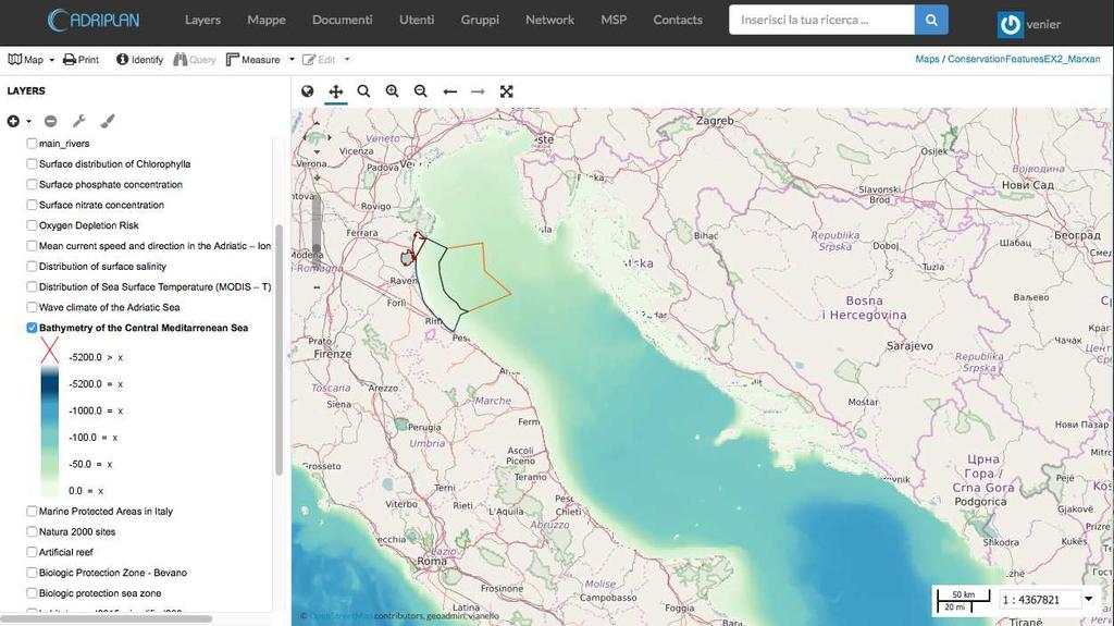
14 ADRIPLAN DATA PORTAL Collecting and making available MSP data in ADRIPLAN Tool to be used by partners collaboratively for: Discover, view and access available data through metadata Create maps merging available data Download data to be used in the project Populate the data portal with new data Incremental implementation during the project User (group) profiles to customize interaction and availability of data Opensource tools: modular and extensible for development of specific functionalities
 ~60 maps (combination of layers) Other hundreds of layers through standard OGC-services ~60 users")
15 ADRIPLAN DATA PORTAL - WHAT'S INSIDE ~150 vector layers (points, lines,areas) ~50 rasters layers (images, models, interpolations) ~60 maps (combination of layers) Other hundreds of layers through standard OGC-services ~60 users

16 DATA PORTAL ACCESS AND USE STATISTICS

17 OUR FOCUS: TOOLS SUPPORTING MSP Moving from data inventory, to integration within the ADRIPLAN methodology, to supporting tool for MSP planning Use, customization, development, integration in the Portal
18 TYPES OF MSP TOOLS Identifying spatial interactions between activities Risk assessment of cumulative effects of human pressures Decision support systems Web-based vs. GIS-based tools Designed for different users (programmer, scientist, strategic planner, case officer, public), To address different stages of the plan
 by choosing the analysis area, the data layers, the analysis grid cell The")

19 TOOLS4MSP Collecting and making available MSP data in ADRIPLAN Tool to be used by partners collaboratively for: GeoNode plugin (python) Direct interaction with stored data The users can build several scenarios (called Case Studies) by choosing the analysis area, the data layers, the analysis grid cell The output includes: geographical layers, raw data, base statistics and graphs The spatial outputs from each run are automatically saved and published through the portal St ano M n gon t al Op n sourc tools to support Int grat d Coastal Manag m nt and Maritim Spatial Planning. DOI: /p rj.pr prints.2245v1
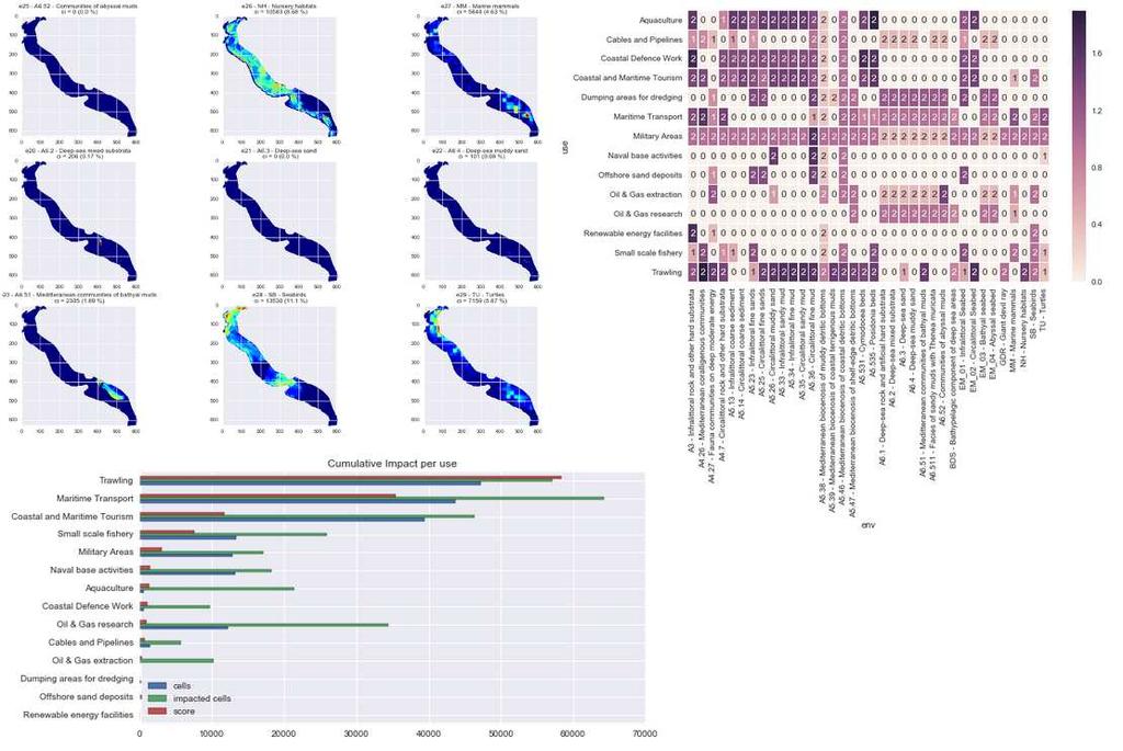
20 TOOL4MSP - CUMULATIVE IMPACT Identify areas in the marine space where the environmental components are more exposed to anthropogenic pressures Activities and uses (e.g. Maritime transport) Environmental components (e.g. Marine mammals) Pressures (e.g. Underwater noise) Sensitivities: the sensitivity of each environmental component to each pressure generated by a maritime use firstly introduced by Halpern et al. (2008) at global scale, then implemented in several Marine Regions (Mediterranean by Micheli et al. (2013), Baltic Sea by (Korpinen et al., 2013), and North Sea (Andersen et al., 2013)).


21 EXTENDED DATA AND VISUAL REPORTS

22 MARXAN IMPLEMENTATION TO THE ADRIATIC-IONIAN REGION

23 WHEN, WHERE AND WHY WE USE MARXAN?

24 PROPOSED FRAMEWORK FOR THE ADRIATIC-IONIAN REGION CASE STUDY adapted from Mazor et al., The Crowded Sea: Incorporating Multiple Marine Activities in Conservation Plans Can Significantly Alter Spatial Priorities. PLoS ONE 9, DOI: /journal.pone STEP 1= description of the study area in different scales and relative main issues (on the basis of Adriplan results, issues, priorities and needs), answering to the need to apply systematic approaches at various scales (Giakoumi et al., 2012) STEP 2= definition of the aim of the analysis to be realized carrying out different case studies (on conservation protection and on major economic marine activities for the area) STEP 3= definition of conservation features, costs, targets for each case study STEP 4= collecting and pre-processing data layers for creating the input datasets STEP 5= implementation of the spatial prioritization tool: running Marxan for the different case studies on different domains STEP 6=evaluate trade-offs/development of planning scenarios to discuss with stakeholders STEP 7= rerun with different targets STEP 8= final portfolio of planning scenarios ready for discussion with decision-makers. The final plans will meet biodiversity targets; will achieve economic objectives, while minimize costs.

25 STUDY AREA DOMAIN 1 ADRIATIC-IONIAN REGION DOMAIN 2 ITALIAN SIDE OF THE AIR

26 STUDY AREA DOMAIN 3 MARINE WATERS OF EMILIA ROMAGNA REGION
27 GENERAL AIM OF THE ANALYSIS On the basis of the peculiarities of the AIR (EUSAIR pillars), the following priorities, both in terms of environmental protection and socio-economy productivity, have been identified for the areas of study: Protection of the environment: in line with MSFD (e.g. protecting at least 10% of the seabed is currently exploited by trawling) and Biodiversity Convention (increasing the 10% of marine areas); Sustainable development of aquaculture (also focusing on the proposal for new offshore areas between 3nm and 12 nm); Sustainable development of fisheries (both commercial and artisanal); Sustainable development of tourism: guaranteed by the previous 3 points as well as preserving transport and sand deposits activities (specific activity for the Emilia Romagna region), as important activities of the area.

28 SPECIFIC AIM OF THE ANALYSIS Specific objectives will be achieved by developing specific case studies: Identifying priority areas to design networks of MPAs for biodiversity conservation; Identifying priority areas to design aquaculture farms, favouring in particular offshore sites.
29 CONSERVATION FEATURES 1

30 CONSERVATION FEATURES 2
31 CONSERVATION FEATURES 3

32 COSTS
33 LESSONS WE ARE LEARNING ON THE USE OF MARXAN stakeholders/expert involvement for the finalization of the problem, the observation of specific data/thresholds, and in-depth literature review consider the time required to observe and elaborate data (pre-processing phase) importance of a tool for data collection and management (Adriplan Data Portal) need for a clear definition of the problem and of the goals (it was useful to start from the Adriplan experience, as well as to adopt the workflow of Mazor et al., 2014) different approach for the biodiversity conservation and aquaculture analyses

34 FROM DATA TO WISDOM: INFORMING MSP AND EUSAIR IMPLEMENTATION IN THE ADRIATIC IONIAN REGION by A. Sarretta, C. Venier, A. Barbanti, S. Menegon, D. Depellegrin is licensed under a Creative Commons Attribution 4.0 International License. It can be viewed online here and downloaded here. To cite this work please refer to: Al ssandro Sarr tta, Chiara V ni r, Andr a Barbanti, St ano M n gon, Dani l D p ll grin (2016). From data to wisdom: in orming MSP and EUSAIR impl m ntation in th Adriatic Ionian R gion. DOI: /m9. igshar
Open source tools to support Integrated Coastal Management and Maritime Spatial Planning
 Open source tools to support Integrated Coastal Management and Maritime Spatial Planning Stefano Menegon 1, Alessandro Sarretta 1, Andrea Barbanti 1, Elena Gissi 2, and Chiara Venier 1 1 Consiglio Nazionale
ADRIPLAN: an EU funded pilot project on MSP in the Adriatic Ionian Region Pierpaolo Campostrini CORILA and CNR-ISMAR
 ADRIPLAN: an EU funded pilot project on MSP in the Adriatic Ionian Region Pierpaolo Campostrini CORILA and CNR-ISMAR ADRiatic Ionian maritime spatial PLANning ADRIPLAN PROJECT ADRIPLAN has the objective
ADRIPLAN Project Prof. Francesco Musco, IUAV University of Venice
 ADRIPLAN Project Prof. Francesco Musco, IUAV University of Venice msp@iuav.it Riga, Baltic MSP Forum, 17/18 June 2014 Outline The ADRIPLAN Project (DG MARE) Methodological insights Planning Design & interaction
ADRIPLAN: a Pilot Project on MSP implementation in the AdriaticIonian Region
 The Eleventh International Training Workshop Integrated Maritime Strategy and Marine Spatial Planning in the Mediterranean & the Black Sea Dalyan, Turkey 20 Sept 2016 ADRIPLAN: a Pilot Project on MSP implementation
Aquaculture Spatial Planning: The case of Greece
 Aquaculture Spatial Planning: The case of Greece Nikos Anagnopoulos Panhellenic Association for Small-Medium sized Aquaculture Enterprises Panhellenic Association for Small-Medium sized Aquaculture Enterprises
MR. George ALEXAKIS, parallel session 3. "Mediterranean Sea Region. laying the conditions. for sustainable growth and jobs"
 parallel session 3 "Mediterranean Sea Region laying the conditions for sustainable growth and jobs" MR. George ALEXAKIS, elected Regional Councillor of Crete, Greece and representative of Crete in CRPM.
Mediteranean sea issues in the view of ESPON ESaTDOR project and Marine Spatial Planning in Slovenia
 DIREKTORAT ZA PROSTOR, GRADITEV IN STANOVANJA Mediteranean sea issues in the view of ESPON ESaTDOR project and Marine Spatial Planning in Slovenia BlueMed meeting of stakeholders on a micro-regional level
Integrated Strategies in regional development
 Inspire policy making by territorial evidence ESPON Seminar Territories Acting for Economic Growth: Using territorial evidence to meet challenges towards 2020 Integrated Strategies in regional development
MODELS AND TOOLS FOR GOVERNANCE OF
 Working Papers Collection No. 1/2015 MODELS AND TOOLS FOR GOVERNANCE OF THE ADRIATIC AND IONIAN SEAS www.unimc.it/maremap NATIONAL POLITICS AND EU POLITICS: THE MARITIME SPATIAL PLANNING AND INTEGRATED
Maritime Spatial Planning Framework Directive Supported by INSPIRE
 Maritime Spatial Planning Framework Directive Supported by INSPIRE Andrej Abramić, Vanda Nunes de Lima, Paul Smits, Emanuele Bigagli, Chris Schubert European Commission Joint Research Centre Institute
EUSAIR on sea topics from Slovenian perspective
 MINISTRY OF FOREIGN AFFAIRS REPUBLIC OF SLOVENIA EUSAIR on sea topics from Slovenian perspective Mag. Andreja Jerina National Coordinator 4 EU MRS: 270 millions of population 19 MS 12 non MS Sea basin
Maritime Spatial Planning: Transboundary Cooperation in the Celtic Seas Looking Ahead
 Maritime Spatial Planning: Transboundary Cooperation in the Celtic Seas Looking Ahead Looking ahead MSP in the context of the European Maritime and Fisheries Fund (EMFF) and beyond SIMCelt Final Conference
Coastal Mapping Follow on? Bruno Frachon Corine Lochet Gaël Morvan
 Coastal Mapping Follow on? Bruno Frachon Corine Lochet Gaël Morvan Shared objectives; IHO DG MARE CPMR Development of a Joint European Coastal Mapping Programme (JECMaP) within the IHO EU network with
SPLAN-Natura Towards an integrated spatial planning approach for Natura th January, 2017 Brussels. Commissioned by DG Environment
 SPLAN-Natura 2000 Towards an integrated spatial planning approach for Natura 2000 Commissioned by DG Environment 17 th January, 2017 Brussels V. Simeonova (Ph.D.) Drivers towards integrating Biodiversity
Information System as a Tool for Marine Spatial Planning The SmartSea Vision and a Prototype
 Information System as a Tool for Marine Spatial Planning The SmartSea Vision and a Prototype Ari Jolma Marine Research Centre Finnish Environment Institute May 10, 2017 ISESS 2017, Zadar, Croatia Contents
From the Venice Lagoon Atlas towards a collaborative federated system
 From the Venice Lagoon Atlas towards a collaborative federated system City of Venice Alessandro Mulazzani CORILA Consortium for Coordination of Research Activities Concerning the Venice Lagoon System ISMAR-CNR
Geological information for Europe : Towards a pan-european Geological Data Infrastructure
 Geological information for Europe : Towards a pan-european Geological Data Infrastructure Integrating geoscientific information for EU competitiveness Co-funded by the European Union European societal
1. Baltic SCOPE Towards coherence and cross-border solutions in Baltic Maritime Spatial Plans
 NSHC 32th Conference Explanatory Note Dublin, Ireland Item E.2 MSP 21-23 June 2016 Germany Cross border MSP for the EEZ, a case study from the Baltic Sea The Federal Maritime and Hydrographic Agency of
Country Fiche Estonia
 Country Fiche Estonia Updated October 2017 1. General information Size of internal waters (to the baseline) and territorial sea (12-nm zone from the baseline) approximately 25 200 km 2. Exclusive economic
CONCEPTUAL FRAMEWORK FOR MARINE SPATIAL PLANNING IN THE MEDITERRANEAN
 CONCEPTUAL FRAMEWORK FOR MARINE SPATIAL PLANNING IN THE MEDITERRANEAN CONCEPTUAL FRAMEWORK FOR SPATIAL PLANNING IN THE MEDITERRANEAN LEGAL NOTICE The designations employed and the presentation of the material
Marine/Maritime Spatial Planning Andrej Abramić
 Marine/Maritime Spatial Planning Andrej Abramić EcoAqua SUMMER SCHOOL: Ecosystem approach to aquaculture 26-29th of October 2015 Research and Technology to enhance excellence in Aquaculture development
Status of implementation of the INSPIRE Directive 2016 Country Fiches. COUNTRY FICHE Netherlands
 Status of implementation of the INSPIRE Directive 2016 Country Fiches COUNTRY FICHE Netherlands Introduction... 1 1. State of Play... 2 1.1 Coordination... 2 1.2 Functioning and coordination of the infrastructure...
Implementation of the Political Declaration on energy cooperation between the North Seas Countries. Support Group 1 on Maritime Spatial Planning
 Implementation of the Political Declaration on energy cooperation between the North Seas Countries Support Group 1 on Maritime Spatial Planning Work Programme 1. Work area as outlined in Annex I to the
Additional information (material for interactions and analysis chapter) to document 3/1, the PLAN BOTHNIA MSP Assessment
 to document 3/1, the PLAN BOTHNIA MSP Assessment") Co-Financed Under European Integrated Maritime Policy PLAN BOTHNIA MSP 2/2011 MSP Assessment Add 1 PLAN BOTHNIA MSP 2 Uppsala, Sweden June 14-15 2011 Agenda Item 3 PLAN BOTHNIA MSP Assessment Document
Co-Financed Under European Integrated Maritime Policy PLAN BOTHNIA MSP 2/2011 MSP Assessment Add 1 PLAN BOTHNIA MSP 2 Uppsala, Sweden June 14-15 2011 Agenda Item 3 PLAN BOTHNIA MSP Assessment Document
Key Indicators for Territorial Cohesion & Spatial Planning Stakeholder Workshop - Project Update. 13 th December 2012 San Sebastián, Basque Country
 Key Indicators for Territorial Cohesion & Spatial Planning Stakeholder Workshop - Project Update 13 th December 2012 San Sebastián, Basque Country Key Aims Explore the use of territorial data in developing
Major human activities affecting Norwegian coastal marine ecosystems; present status and challenges
 Major human activities affecting Norwegian coastal marine ecosystems; present status and challenges Erlend Moksness PICES Annual Meeting - Science Board Symposium 26. October 2009, Jeju, Korea FUTURE:
Spatial Planning in Canada s Maritimes Region. Maritimes Region
 Spatial Planning in Canada s Maritimes Region Glen Herbert, Scott Coffen-Smout Smout,, and Tanya Koropatnick Oceans and Coastal Management Division Ecosystem Management Branch Fisheries and Oceans Canada
Country Fiche Estonia
 Country Fiche Estonia Deleted: October Updated May 2018 Deleted: 7 1. General information Size of internal waters (to the baseline) and territorial sea (12-nm zone from the baseline) approximately 25 200
EU HOs in Mediterranean and Black Sea (MBS) CROATIA FRANCE GREECE ITALY MALTA X SLOVENIA X SPAIN ROMANIA X
 CROATIA FRANCE GREECE ITALY MALTA X SLOVENIA X SPAIN ROMANIA X") EU HOs in Mediterranean and Black Sea (MBS) CROATIA FRANCE GREECE ITALY MALTA X SLOVENIA X SPAIN ROMANIA X Croatia Current status of hydrographic survey in acc. IHO C-55 pub. criteria Croatia Croatia by
EU HOs in Mediterranean and Black Sea (MBS) CROATIA FRANCE GREECE ITALY MALTA X SLOVENIA X SPAIN ROMANIA X Croatia Current status of hydrographic survey in acc. IHO C-55 pub. criteria Croatia Croatia by
Natura 2000 in the marine environment: state of implementation and next steps
 Life on the blue planet: biodiversity research and the new European marine policies EPBRS European Platform on Biodiversity Research Strategy Porto, Portugal 7-9 November 2007 Natura 2000 in the marine
Towards coherent maritime spatial planning in the Baltic Sea Region, transnational and project perspective Talis Linkaits Head of VASAB Secretariat
 3 June 2013 Riga PartiSEApate Workshop MSP as Tool for Underwater Cultural Heritage Management in the Baltic Sea Towards coherent maritime spatial planning in the Baltic Sea Region, transnational and project
Marine Spatial Planning as an important tool for implementing the MSFD
 Marine Spatial Planning as an important tool for implementing the MSFD Risto Kalliola Tallinn, Nov. 16 th 2012 DEPARTMENT OF GEOGRAPHY AND GEOLOGY University of Turku, Finland Ten principles to provide
MESMA: An integrated tool box to support an ecosystem based spatial management of marine areas
 MESMA: An integrated tool box to support an ecosystem based spatial management of marine areas Stelzenmüller, V., Stamford, T., Vassilopoulou, V., Kastanevakis, S., Vincx, M, Vanaverbeke, J., Rabaut, M.,
Findings and recommendations from Central Baltic case
 W 1/1 Recommendations on transboundary planning from Baltic SCOPE Findings and recommendations from Central Baltic case Ingūna Urtāne Director of Spatial Planning Department of the Ministry of Environmental
Emerging tensions between blue growth and good environmental status
 Emerging tensions between blue growth and good environmental status Dr Peter Jones, Reader in Environmental Governance, Dept of Geography, University College London www.bnycharters.com Slides @PJSJones
Outline National legislative & policy context Regional history with ESSIM ESSIM Evaluation Phase Government Integration via RCCOM Regional ICOM Framew
 What MSP Implementation could change in the Maritimes Region Tim Hall, Regional Manager Oceans and Coastal Management Division Ecosystem Management Branch Fisheries and Oceans Canada Maritimes Region BIO
Tackling MSP integration challenges in the BSR
 Towards sustainable governance of Baltic marine space 2015 2018 BALTSPACE Towards sustainable governance of Baltic marine space Tackling MSP integration challenges in the BSR Michael Gilek, Södertörn University,
geoporrtal of Tools & Data for sustainable Management of coastal and marine Environment (ADRION205)
") PORTODIMARE geoporrtal of Tools & Data for sustainable Management of coastal and marine Environment (ADRION205) Minutes of the PORTODIMARE International Conference on ICZM&MSP 11/2018 Page 1 PORTODIMARE
PORTODIMARE geoporrtal of Tools & Data for sustainable Management of coastal and marine Environment (ADRION205) Minutes of the PORTODIMARE International Conference on ICZM&MSP 11/2018 Page 1 PORTODIMARE
Seabed knowledge In support of UN SDGs
 Seabed knowledge In support of UN SDGs Evert Flier Fiskerifaglig forum 2. november 2017 Hydrography & small scale fishing Hydrography in Transition Serving the Maritime Community Hydrography in Transition
Arctic Spatial Data Infrastructure Enabling Access to Arctic Location-Based Information
 Arctic Spatial Data Infrastructure Enabling Access to Arctic Location-Based Information Arctic SDI Side Event Co-Chairs: Arvo Kokkonen Arctic SDI Board Chair & Director General, National Land Survey of
Marine Spatial Planning Leslie-Ann McGee Battelle Memorial Institute
 Marine Spatial Planning Leslie-Ann McGee Battelle Memorial Institute Rev061708 1 Marine Spatial Planning What is it? Why is it different? Where is it currently being employed? What is happening in the
EA SEA-WAY Project. 7 th Coordination Meeting. WP5 Development of sustainable passenger transport models for the Adriatic basin and capacity building
 EA SEA-WAY Project 7 th Coordination Meeting WP5 Development of sustainable passenger transport models for the Adriatic basin and capacity building 3 rd Cross Border Board Ravenna, January 26, 2016 The
Tua Nylén and Harri Tolvanen. Deliverable D.T3.2.1 Guidelines for harmonising, producing and managing crossborder.
 Tua Nylén and Harri Tolvanen Deliverable D.T3.2.1 Guidelines for harmonising, producing and managing crossborder spatial data Cross-border case 28.7.2017 CONTENTS BACKGROUND... 2 FREQUENTLY USED TERMS...
Marine Spatial Planning: A Tool for Implementing Ecosystem-Based Management
 Marine Spatial Planning: A Tool for Implementing Ecosystem-Based Management Steven Murawski, Ph.D., Ecosystem Goal Team Lead National Oceanic and Atmospheric Administration NOAA November 16, 2009 1 To
Maritime Spatial Planning in the Baltic Sea Region
 Maritime Spatial Planning in the Baltic Sea Region Talis Linkaits Head of VASAB Secretariat 20 May 2015 Helsinki A cooperation of ministers of the 11 Baltic Sea Region countries responsible for spatial
New EU efforts to assess the state of the marine environment: the EMODnet Chemistry pilot project
 New EU efforts to assess the state of the marine environment: the EMODnet Chemistry pilot project Matteo Vinci and Alessandra Giorgetti, OGS NODC group, OCE September 2013 - IMDIS 2013, Lucca Overview
2012 FORUM OF MARINE PROTECTED AREAS IN THE MEDITERRANEAN ANTALYA, TURKEY
 2012 FORUM OF MARINE PROTECTED AREAS IN THE MEDITERRANEAN ANTALYA, TURKEY SPECIAL EVENT Challenges for Open Seas MPAs in the Mediterranean region November 27, 2012. 15h00-16H00 Slide # 1 2012 FORUM OF
Cross-border Maritime Spatial Plan for the Black sea - Romania and Bulgaria project
 Cross-border Maritime Spatial Plan for the Black sea - Romania and Bulgaria project in Romania and Bulgaria Plan Presentation A first step in the management of the marine areas of Romania and Bulgaria
Oman NSDI Business Values and Future Directions. Hassan Alawi Alghazali Acting Director General National Spatial Data Infrastructure
 Oman NSDI Business Values and Future Directions Hassan Alawi Alghazali Acting Director General National Spatial Data Infrastructure Presentation Outline Geospatial Maturity Current Challenges NCSI s Role
The Baltic Sea Region Maritime Spatial Planning Data Expert Sub-group. First Report 2015/2016/
 The Baltic Sea Region Maritime Spatial Planning Data Expert Sub-group First Report 2015/2016/2017 21.04.2017. Contents 1. Glossary 2 2. Introduction. 3 3. MSP Data. 5 3.1. Input Data. 5 3.2 Output Data.
Geospatial workflows and potential applications to the Sustainable Development Goals of countries in West Asia
 Geospatial workflows and potential applications to the Sustainable Development Goals of countries in West Asia Ameer Abdulla, PhD Senior Advisor, European Topic Center for Spatial Analysis, Spain Associate
INSPIREd solutions for Air Quality problems Alexander Kotsev
 INSPIREd solutions for Air Quality problems Alexander Kotsev www.jrc.ec.europa.eu Serving society Stimulating innovation Supporting legislation The European data puzzle The European data puzzle 24 official
PLAN BOTHNIA MARE/2009/16
 PLAN BOTHNIA MARE/2009/16 Hermanni Backer Project Manager HELCOM Secretariat Partner Kick-Off Meeting Nordregio, Stockholm December 16 2010 Photo: Elena Bulycheva PLAN BOTHNIA MARE/2009/16 Co-financed
An analysis of Agile conferences papers: a snapshot of the GI&GIS research in Europe
 An analysis of Agile conferences papers: a snapshot of the GI&GIS research in Europe Pasquale Di Donato, Mauro Salvemini University of Rome La Sapienza Piazza Borghese 9 00186 Roma, Italy pasquale.didonato@uniroma1.it,
Interest for HOs to cooperate with EU Commission:
 Plenary session of the European IHO Network Working Group (IENWG) Interest for HOs to cooperate with EU Commission: Why HOs and the EU Commission need a closer cooperation Rear Admiral (N) Luigi SINAPI
HELSINKI COMMISSION Baltic Marine Environment Protection Commission
 HELSINKI COMMISSION Baltic Marine Environment Protection Commission HELCOM RECOMMENDATION 24/10 Adopted 25 June 2003, having regard to Article 20, Paragraph 1 b) of the 1992 Helsinki Convention IMPLEMENTATION
National Perspectives - Portugal. Margarida Almodovar
 National Perspectives - Portugal Margarida Almodovar margarida.almodovar@mam.gov.pt from base line to the external limit of the continental shelf behind 200 miles and according to UNCLOS definitions Economic
Enabling Access to Arctic Location Based Information - the Arctic SDI
 Enabling Access to Arctic Location Based Information - the Arctic SDI Jani Kylmäaho Head of Arctic SDI Geoportal WG National Land Survey of Finland SAO Chair, WG Chairs and Executive Secretaries meeting
Designing Networks of Marine Protected Areas in DFO s Three Atlantic Bioregions
 Designing Networks of Marine Protected Areas in DFO s Three Atlantic Bioregions Presentation for Indigenous Protected Areas Workshop Max Westhead, DFO and Adrian Gerhartz-Abraham, Dalhousie March 29, 2017
Marine Spatial Planning in the Baltic Sea Region
 Marine Spatial Planning in the Baltic Sea Region Towards coherence and cross-border solutions in Baltic Maritime Spatial Plans Coordinator & Project manager Dr Ingela Isaksson Swedish Agency for Marine
EMODnet High Resolution Seabed Mapping - further developing and providing a high resolution digital bathymetry for European seas
 EMODnet High Resolution Seabed Mapping - further developing and providing a high resolution digital bathymetry for European seas EGU Fall 2017 meeting New Orleans USA, December 2017 Schaap Dick MARIS,
The Danish Maritime Spatial Data Infrastructure (MSDI) Geodata of the Sea
 Geodata of the Sea") MSDI/MSP The Danish Maritime Spatial Data Infrastructure (MSDI) Geodata of the Sea Components of an infrastructure: DATA - metadata, datasets FUNCTIONALITY - spatial data services, web services and other
MSDI/MSP The Danish Maritime Spatial Data Infrastructure (MSDI) Geodata of the Sea Components of an infrastructure: DATA - metadata, datasets FUNCTIONALITY - spatial data services, web services and other
The Process of Spatial Data Harmonization in Italy. Geom. Paola Ronzino
 The Process of Spatial Data Harmonization in Italy Geom. Paola Ronzino ISSUES Geospatial Information in Europe: lack of data harmonization the lack of data duplication of data CHALLENGES Challenge of INSPIRE:
MARINE STUDIES (MARINE SPATIAL PLANNING & MANAGEMENT) MASTER S DEGREE
 MASTER S DEGREE") MARINE STUDIES (MARINE SPATIAL PLANNING & MANAGEMENT) MASTER S DEGREE Influence, lead and provide decision making support for the management and planning of coastal and marine spaces. PROGRAM DESCRIPTION
MARINE STUDIES (MARINE SPATIAL PLANNING & MANAGEMENT) MASTER S DEGREE Influence, lead and provide decision making support for the management and planning of coastal and marine spaces. PROGRAM DESCRIPTION
Roadmap to interoperability of geoinformation
 Roadmap to interoperability of geoinformation and services in Europe Paul Smits, Alessandro Annoni European Commission Joint Research Centre Institute for Environment and Sustainability paul.smits@jrc.it
- West Africa. Abuja, Nigeria May Fredericton Canada Heeswijk The Netherlands Washington DC United States Adelaide Australia
 A Case Study in Land and Sea Data Interoperability Patricia GASPAR(Netherlands), Andrew HOGGARTH(Canade), Gordon JOHNSTON(UK), Charles de JONG(Netherlands) - West Africa Abuja, Nigeria - 6-10 May 2013
The Added Value of Geospatial Data in a Statistical Office. Pedro Diaz Munoz Director Sectoral and Regional Statistics EUROSTAT European Commission
 The Added Value of Geospatial Data in a Statistical Office Pedro Diaz Munoz Director Sectoral and Regional Statistics EUROSTAT European Commission Why integrate Responsibility of all the information we
Introduction to EMODnet
 Introduction to EMODnet Antonio Novellino Torino, 14-15 Ottobre 2015 What is EMODnet? Initiated by the European Commission in response to the EU Future Maritime Policy and Blue Growth, launched in June
MARINE SPATIAL PLANNING & MARINE CADASTRE: CHALLENGES AND ISSUES
 MARINE SPATIAL PLANNING & MARINE CADASTRE: CHALLENGES AND ISSUES Roger Longhorn Secretary General, GSDI Association rlonghorn@gsdi.org Member, IHO Marine SDI Working Group ral@alum.mit.edu Member, UNESCO
Identification of maritime spatial planning best practices in the Baltic Sea Region and other EU maritime regions
 Identification of maritime spatial planning best practices in the Baltic Sea Region and other EU maritime regions PLAN BOTHNIA Baltic Sea Region Stakeholder Meeting Jacek Zaucha, Magdalena Matczak Two
Mediterranean Sea and Territorial Development, Opportunities and Risks
 EESC Hearing Towards an EU Macro-Regional Strategy for the Mediterranean Mediterranean Sea and Territorial Development, Opportunities and Risks Michaela Gensheimer Structure of Intervention Part I: What
Marine Spatial Planning Experience from Mecklenburg-Vorpommern (Germany) By Susan Toben
 By Susan Toben") Marine Spatial Planning Experience from Mecklenburg-Vorpommern (Germany) By Susan Toben Ministry of Transport, Building and Regional Development Mecklenburg Vorpommern PlanCoast Lead Partner Administrative
Marine Spatial Planning Experience from Mecklenburg-Vorpommern (Germany) By Susan Toben Ministry of Transport, Building and Regional Development Mecklenburg Vorpommern PlanCoast Lead Partner Administrative
Maritime Spatial Planning in the Baltic Sea Region
 Maritime Spatial Planning in the Baltic Sea Region Past, present, perspective Talis Linkaits VASAB Secretariat XIX International Environmental Forum 22 March 2018, Saint Petersburg A cooperation of ministers
econtentplus GS Soil
 econtentplus GS Soil General aims Assessment and strategic development of INSPIRE compliant Geodata-Services for European Soil Data BPN on basis of the EU 2007/2/EC (INSPIRE) Directive for Annex III theme
a national geological survey perspective François ROBIDA BRGM (French Geological Survey)
") a national geological survey perspective François ROBIDA BRGM (French Geological Survey) Pre-Conference Seminar on Socio-Economic Value of Geospatial for National and Regional Development 21 August 2017,
a national geological survey perspective François ROBIDA BRGM (French Geological Survey) Pre-Conference Seminar on Socio-Economic Value of Geospatial for National and Regional Development 21 August 2017,
Country Fiche Latvia Updated October 2016
 Country Fiche Latvia Updated October 2016 1. General information Marine area under Latvian jurisdiction includes inland sea waters, Territorial sea (12 nautical miles from the baseline) and exclusive economic
Croatian physical planning system and strategic approach to MSP
 W 1/7 Past two years all over the Europe: case studies 2 Croatian physical planning system and strategic approach to MSP Vesna Marohnić Kuzmanović Head of Department Croatian Institute for Spatial Development
Marine Spatial Planning (MSP): A practical approach to ecosystembased
: A practical approach to ecosystembased") Marine Spatial Planning (MSP): A practical approach to ecosystembased management Erik Olsen, Institute of Marine Research, Norway Fanny Douvere, International Oceanographic Commission Overview Why we need
Marine Spatial Planning (MSP): A practical approach to ecosystembased management Erik Olsen, Institute of Marine Research, Norway Fanny Douvere, International Oceanographic Commission Overview Why we need
Towards international cooperation in the development of Marine Spatial Plans for the North Pacific: economic, social, and environmental dimensions
 Towards international cooperation in the development of Marine Spatial Plans for the North Pacific: economic, social, and environmental dimensions A.V. Sereda, V.B. Lobanov V.I. Il ichev Pacific Oceanological
The HELCOM Baltic Sea Action Plan and Marine Spatial Planning
 The HELCOM Baltic Sea Action Plan and Marine Spatial Planning Anne Christine Brusendorff Executive Secretary HELCOM The Baltic Sea Our common responsibility. Workshop on Integrated Sea Use management Stockholm
EuroGEOSS Protected Areas Pilot
 EuroGEOSS Protected Areas Pilot Max Craglia European Commission Joint Research Centre Part 1: the present MyNatura2000 Mobile app. Awareness raising & volunteered data collection. Natura2000 covers 18%
Infrastructure for Spatial Information in Europe (INSPIRE)
") Infrastructure for Spatial Information in Europe (INSPIRE) 2011 GISCO Working Party 8-9.3.2012 INSPIRE is about improving access to spatial information: the environment doesn t stop at borders EU Geoportal
Infrastructure for Spatial Information in Europe (INSPIRE) 2011 GISCO Working Party 8-9.3.2012 INSPIRE is about improving access to spatial information: the environment doesn t stop at borders EU Geoportal
IAEG SDGs WG GI, , Mexico City
 IAEG SDGs WG GI, 12-14.12.2016, Mexico City UN-GGIM:Europe s perspective and activities to support better integration of geospatial information and statistics and the UN SDG monitoring Pier-Giorgio Zaccheddu,
Jordan's Strategic Research Agenda in cultural heritage
 Jordan's Strategic Research Agenda in cultural heritage Analysis of main results Alessandra Gandini Amman, Jordan 3 rd November 2013 Main objectives The work performed had the main objective of giving
INSPIRE a backbone in spatially enabling the digital maritime society in the Baltic Sea region
 Lise Schrøder (AAU), Lena Hallin Pihlatie (SYKE) & Manuel Frias Vega (Helcom) INSPIRE a backbone in spatially enabling the digital maritime society in the Baltic Sea region Agenda The Baltic LINes project
BalticBOOST Appendix 1, WP 3.3 Deliverable 1 Final report 14 February 2017
 Theme 1: Biodiversity This is a deliverable from the BalticBOOST project that was coordinated by HELCOM and co-financed by the European Union in 2015-2016 as part of the programme DG ENV/MSFD Action Plans/2016.
MARINE PLANNING IN THE NETHERLANDS
 MARINE PLANNING IN THE NETHERLANDS Hermien Busschbach Ministry of Transport, Public Works and Water Management (DG Water) Bremen, 2 May 2007 Marine Planning in the Netherlands OUTLINE policy context; international
BURGAS CASE STUDY: LAND-SEA INTERACTIONS. Dr. Margarita Stancheva
 BURGAS CASE STUDY: LAND-SEA INTERACTIONS Dr. Margarita Stancheva Name of presentation NEED FOR COHERENCE BETWEEN LAND AND SEA ACTIVITIES Name presenter Burgas is the fourth largest city in Bulgaria and
Realizing benefits of Spatial Data Infrastructure A user s perspective from Environment Agency - Abu Dhabi
 Realizing benefits of Spatial Data Infrastructure A user s perspective from Environment Agency - Abu Dhabi Anil Kumar Director, Environment Information Management 26 April 2012 Geospatial World Forum,
Local Development Pilot Project: Island of Cres. Ranka Saračević Würth, Ministry of Culture, Republic of Croatia
 Local Development Pilot Project: Island of Cres Ranka Saračević Würth, Ministry of Culture, Republic of Croatia BACKGROUND, RATIFICATION OF THE FARO CONVENTION BY REPUBLIC OF CROATIA The Framework Convention
Ecosystem-Based Approach in MSP
 Ecosystem-Based Approach in MSP 16th Meeting of the joint HELCOM-VASAB Maritime Spatial Planning Working Group Ministry of Environment Aleksanterinkatu 7, Helsinki 8.-9. May 2018 Prof. Dr. jur. Gerold
About peer review missions related to data management
 PEER REVIEW WORKSHOP ABOUT DATA MANAGEMENT Introduction Paul HAENER International Office for Water FRANCE p.haener@oieau.fr October 2016 About peer review missions related to data management 2 1 Data management
BOSNIA AND HERZEGOVINA
 Studies to support the development of sea basin cooperation in the Mediterranean, Adriatic and Ionian, and Black Sea CONTRACT NUMBER MARE/2012/07 - REF. NO 2 REPORT 1 - ANNEX 2.2 COUNTRY FICHE - ANNEX
INSPIRE Basics. Vlado Cetl European Commission Joint Research Centre. https://ec.europa.eu/jrc/
 INSPIRE Basics Vlado Cetl European Commission Joint Research Centre https://ec.europa.eu/jrc/ Serving society Stimulating innovation Supporting legislation Outline SDI? Why European SDI? INSPIRE Policy
Applied Geoscience and Technology Division SOPAC. Joy Papao, Risk Information Systems Officer
 Joy Papao, Risk Information Systems Officer Secretariat of the Pacific Community SPC 22 Pacific Island States Head office in Noumea, New Caledonia 2 Regional offices (Pohnpei and Honiara) 600 staff 9 Technical
INSPIRE - A Legal framework for environmental and land administration data in Europe
 INSPIRE - A Legal framework for environmental and land administration data in Europe Dr. Markus Seifert Bavarian Administration for Surveying and Cadastre Head of the SDI Office Bavaria Delegate of Germany
Strategic Environmental Assessment / Environmental Impact Assessment
 Contacts MSP National Level Zrinka Sindler Ministry of Construction and Physical Planning Head of Department Ph.: +385 1 3712747 E-mail: zrinka.sindler@mgipu.hr Sandra Momcilovic Ministry of Construction
Introduction to IMP: need and added value
 Introduction to IMP: need and added value Christophe Le Visage Consultant Stratégies Mer et Littoral 1 Summary IMP : Why? The case for integration 1 What is IMP? 2 Content, process IMP: Added Value 3 2