PLAN BOTHNIA MARE/2009/16
|
|
|
- Moses Washington
- 5 years ago
- Views:
Transcription


1 PLAN BOTHNIA MARE/2009/16 Hermanni Backer Project Manager HELCOM Secretariat Partner Kick-Off Meeting Nordregio, Stockholm December Photo: Elena Bulycheva PLAN BOTHNIA MARE/2009/16 Co-financed under European Integrated Maritime Policy
2 European Background EU DG MARE launched a Maritime Spatial Planning roadmap 2008 MSP as means to implement Integrated Maritime Policy -IMP Two supporting 18 mth preparatory actions calls launched in 2009 Baltic PLAN BOTHNIA (Dec 2010-) North Sea -MASPNOSE (Dec 2010-) More develoments on the way (?)
3 Baltic dimensions toward more integrated management? Integrated regional scale transboundary dialogue on spatial allocation ongoing e.g. coherence between Marine Protected Areas, IMO Routing Measures Fisheries EU MSFD & EU IMP & EU BS Strategy HELCOM 2007 Baltic Sea Action Plan & VASAB initiatives HELCOM-VASAB MSP WG (May 2010-) Based on a set of joint HELCOM VASAB regional principles (Dec 2010)
4
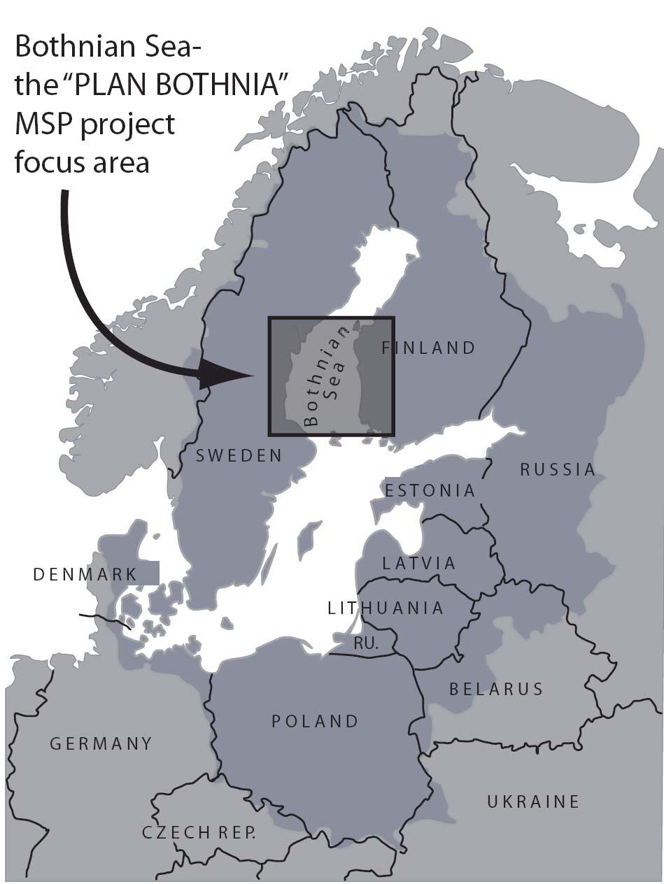
5 Bothnian Sea and PLAN BOTHNIA Bothnian Sea European model area for transboundary MSP Finland and Sweden Good history of cooperation Similar areas on both sides of border
6 Dream Team! VASAB & HELCOM (intergovernmental) Nordregio (Regional planning) SYKE Finnish Environment institute (Environment) Fiskeriverket (Fisheries) Swedish Board of Building Housing and Planning (Planning) Centre for Maritime Studies (Maritime) Finland & Sweden

7 Authorities: Finland National? and regional Ostrobothnia (Åland?) Satakunta (South-West Finland?)


8 Authorities: Sweden National? and regional Västerbotten Västernorrland Gävleborg Uppsala
9 PLAN BOTHNIA Facilitate and Involve regional and national actors Five dedicated meetings Phase I: Assess the need for transboundary MSP (is it even needed?) Assessment document and GIS (Spring- Autumn 2011) Phase II: Propose solutions to eventual issues Test MSP Planning (winter )
10 Assessment I:GIS During 2011 an MSP Assessment must be produced Best available data compilation Fisheries (SBF) Socio-Economy (Nordregio, SBHBP) Maritime developments (CMS) Environment (SYKE, HELCOM) HELCOM GIS (Manuel Frias Vega) Focus on Jan-May, end november 2011

11 HELCOM GIS & Mr. Manuel Frias Vega HELCOM GIS www services
12 Assessment II: Report Assessment document (CMS & HELCOM -all will be involved) existing natural values existing cultural values existing uses possible conflicts developments over time (scenarios) Transboundary issues at focus Is MSP needed here & how should it be done? Start Jan, focus on June-November 2011
13 Test Plan Most open item in project Depends on what FIN & SWE want Drafts based on Assessment and GIS Discussions at the regional meetings Start June 2011, focus on November 2011-March 2012 HELCOM, SBHBP, CMS, Ministries + all
14 Other Components International evaluation (consultant) In the end (Spring 2012) external evaluation Monitoring and evaluation (HELCOM) minor report by spring Stakeholder events (VASAB) 1st October/November 2011? 2nd end of May 2012 (present results) Communication and dissemination (HELCOM) website, MASPNOSE cooperation,final report Region wide minimum recommendations (VASAB, HELCOM)
15 Wider dialogue links to HELCOM-VASAB MSP group Information exchange with DG MARE preparatory action North Sea Other organisations (ICES, NCM)? UNESCO World Marine Heritage (Quark)?
16 The rythm is given by 8 meetings 1 today (Kickoff) 5 during March, June, Sept, Oct (stakeholder), Dec 2 during 2012 March, May (stakeholder) includes 5 meetings with regional partners
17 Meeting 1: Kick Off December 2010 We are here! Introductions & Set the scene Start gathering data and think about assessment Formalities
18 Meeting 2: Introductions and Information First meeting of the regional group March 2011? Introduce the project and get ideas Look together at compiled GIS material and identified issues for assessment- get more material and help Finland?
19 Meeting 3: Assessment 2nd meeting of the regional group June 2011? In depth look at draft assessment and the datasets- get more comments and help Start thinking about alternative scenarios on future developments Sweden?
20 Meeting 4: Planning I 3rd meeting of the regional group September 2011? Final draft of assessment and the datasets- polishing Ideas about the plan should be presented and discussed and developed further by us! External review? Finland?
21 (1st Stakeholder conference) VASAB organises October 2011? Present final draft of assessment discuss other issues MASPNOSE? BaltSeaPlan?
22 Meeting 5: Planning II 4th meeting of the regional group December 2011? Comments and discussions Draft Plan Look at finalised assessment -but develop it further for final report External review? (Sweden?)
23 Meeting 6: Curtains down 5th and last meeting of the regional group March 2012? Final draft plan Look back on the whole process and conclude for the final report What was useful in this activity? Should it be continued somehow? Finland?
24 Closing Conference organised by VASAB May 2012? Presentation of and reflection on results MASPNOSE? External review to present some findings?
25 There is an END to all this!! PLAN BOTHNIA MARE/2009/16 Co-financed under European Integrated Maritime Policy Photo: Elena Bulycheva
PLAN BOTHNIA MSP 1/2011 PLAN BOTHNIA. PLAN BOTHNIA short description (document 3/1) PLAN BOTHNIA MSP 1 Pori, Finland, March
 PLAN BOTHNIA MSP 1 Pori, Finland, March") PLAN BOTHNIA Co-Financed Under European Integrated maritime Policy PLAN BOTHNIA short description (document 3/1) PLAN BOTHNIA MSP 1 Pori, Finland, March 7-8 2011 PLAN BOTHNIA MSP 1/2011 Agenda Item 3 Introduction
PLAN BOTHNIA Co-Financed Under European Integrated maritime Policy PLAN BOTHNIA short description (document 3/1) PLAN BOTHNIA MSP 1 Pori, Finland, March 7-8 2011 PLAN BOTHNIA MSP 1/2011 Agenda Item 3 Introduction
Baltic Sea Region cooperation in Maritime Spatial Planning - HELCOM/VASAB
 Baltic Sea Region cooperation in Maritime Spatial Planning - HELCOM/VASAB Sten Jerdenius Swedish Ministry of the Environment HELCOM/VASAB MSP Group Baltic Sea Region subregional workshop Espoo 31 March
Towards coherent maritime spatial planning in the Baltic Sea Region, transnational and project perspective Talis Linkaits Head of VASAB Secretariat
 3 June 2013 Riga PartiSEApate Workshop MSP as Tool for Underwater Cultural Heritage Management in the Baltic Sea Towards coherent maritime spatial planning in the Baltic Sea Region, transnational and project
Maritime Spatial Planning: Transboundary Cooperation in the Celtic Seas Looking Ahead
 Maritime Spatial Planning: Transboundary Cooperation in the Celtic Seas Looking Ahead Looking ahead MSP in the context of the European Maritime and Fisheries Fund (EMFF) and beyond SIMCelt Final Conference
Marine Spatial Planning in the Baltic Sea Region
 Marine Spatial Planning in the Baltic Sea Region Towards coherence and cross-border solutions in Baltic Maritime Spatial Plans Coordinator & Project manager Dr Ingela Isaksson Swedish Agency for Marine
Maritime Spatial Planning in the Baltic Sea Region
 Maritime Spatial Planning in the Baltic Sea Region Talis Linkaits Head of VASAB Secretariat 20 May 2015 Helsinki A cooperation of ministers of the 11 Baltic Sea Region countries responsible for spatial
Additional information (material for interactions and analysis chapter) to document 3/1, the PLAN BOTHNIA MSP Assessment
 to document 3/1, the PLAN BOTHNIA MSP Assessment") Co-Financed Under European Integrated Maritime Policy PLAN BOTHNIA MSP 2/2011 MSP Assessment Add 1 PLAN BOTHNIA MSP 2 Uppsala, Sweden June 14-15 2011 Agenda Item 3 PLAN BOTHNIA MSP Assessment Document
Co-Financed Under European Integrated Maritime Policy PLAN BOTHNIA MSP 2/2011 MSP Assessment Add 1 PLAN BOTHNIA MSP 2 Uppsala, Sweden June 14-15 2011 Agenda Item 3 PLAN BOTHNIA MSP Assessment Document
Country Fiche Sweden Updated May 2018
 Country Fiche Sweden Updated May 2018 1. General information 2 the territorial sea (12-nm zone) 70,000 km2 the Exclusive Economic Zone 60,000 km2 the EEZ is limited to the central line between adjacent
1. Baltic SCOPE Towards coherence and cross-border solutions in Baltic Maritime Spatial Plans
 NSHC 32th Conference Explanatory Note Dublin, Ireland Item E.2 MSP 21-23 June 2016 Germany Cross border MSP for the EEZ, a case study from the Baltic Sea The Federal Maritime and Hydrographic Agency of
Maritime Spatial Planning in the Baltic Sea Region
 Maritime Spatial Planning in the Baltic Sea Region Past, present, perspective Talis Linkaits VASAB Secretariat XIX International Environmental Forum 22 March 2018, Saint Petersburg A cooperation of ministers
Education in Maritime Spatial Planning European Maritime Days May 22, 2012 Gothenburg
 Education in Maritime Spatial Planning European Maritime Days May 22, 2012 Gothenburg Paula Lindroos, director Baltic Centre for Sustainable Development Uppsala University BUP in Summary A regional university
Identification of maritime spatial planning best practices in the Baltic Sea Region and other EU maritime regions
 Identification of maritime spatial planning best practices in the Baltic Sea Region and other EU maritime regions PLAN BOTHNIA Baltic Sea Region Stakeholder Meeting Jacek Zaucha, Magdalena Matczak Two
The HELCOM Baltic Sea Action Plan and Marine Spatial Planning
 The HELCOM Baltic Sea Action Plan and Marine Spatial Planning Anne Christine Brusendorff Executive Secretary HELCOM The Baltic Sea Our common responsibility. Workshop on Integrated Sea Use management Stockholm
HELCOM-VASAB Maritime Spatial Planning Working Group Twelfth Meeting Gdansk, Poland, February 2016
 HELCOM-VASAB Maritime Spatial Planning Working Group Twelfth Meeting Gdansk, Poland, 24-25 February 2016 Document title MSP exhibition stands at the European Maritime Day 2016 Code 7-3-Add.1 Category INF
Findings and recommendations from Central Baltic case
 W 1/1 Recommendations on transboundary planning from Baltic SCOPE Findings and recommendations from Central Baltic case Ingūna Urtāne Director of Spatial Planning Department of the Ministry of Environmental
Country Fiche Sweden.
 Country Fiche Sweden 1. General information the territorial sea (12- nm zone) 70,000 km2 the Exclusive Economic Zone 60,000 km2 the EEZ is limited to the central line between adjacent states because the
Country Fiche Estonia
 Country Fiche Estonia Updated October 2017 1. General information Size of internal waters (to the baseline) and territorial sea (12-nm zone from the baseline) approximately 25 200 km 2. Exclusive economic
Country Fiche Estonia
 Country Fiche Estonia Deleted: October Updated May 2018 Deleted: 7 1. General information Size of internal waters (to the baseline) and territorial sea (12-nm zone from the baseline) approximately 25 200
ICZM and MSP in the Black Sea Region
 ICZM and MSP in the Black Sea Region Drd. Claudia Coman, Environmental engineer AG ICZM Focal Point, Romania Black Sea Commission Black Sea Commission on the Protection of the Black Sea against Pollution
SIMCelt Supporting Implementation of Maritime Spatial Planning in the Celtic Seas. Patrice Laporte
 SIMCelt Supporting Implementation of Maritime Spatial Planning in the Celtic Seas Patrice Laporte patrice.laporte@shom.fr General background In July 2014 the EU adopted a directive establishing a framework
PartiSEApate: Multi-Level-Governance in Maritime Spatial Planning
 PartiSEApate: Multi-Level-Governance in Maritime Spatial Planning Establish a dialogue amongst MSP actors at ALL LEVELS and develop a proposal for a pan- Bal>c MSP governance structure Angela Schultz Zehden,
INSPIRE a backbone in spatially enabling the digital maritime society in the Baltic Sea region
 Lise Schrøder (AAU), Lena Hallin Pihlatie (SYKE) & Manuel Frias Vega (Helcom) INSPIRE a backbone in spatially enabling the digital maritime society in the Baltic Sea region Agenda The Baltic LINes project
ADRIPLAN: an EU funded pilot project on MSP in the Adriatic Ionian Region Pierpaolo Campostrini CORILA and CNR-ISMAR
 ADRIPLAN: an EU funded pilot project on MSP in the Adriatic Ionian Region Pierpaolo Campostrini CORILA and CNR-ISMAR ADRiatic Ionian maritime spatial PLANning ADRIPLAN PROJECT ADRIPLAN has the objective
Memo: Meeting with Estonian and Finnish MSP authorities Tallinn, Estonia
 Hanna Nieminen & Riku Varjopuro Memo: Meeting with Estonian and Finnish MSP authorities 16.11.2017 Tallinn, Estonia ABSTRACT Title: Memo: Meeting with Estonian and Finnish MSP authorities Authors: Hanna
The Baltic Sea Region Maritime Spatial Planning Data Expert Sub-group. First Report 2015/2016/
 The Baltic Sea Region Maritime Spatial Planning Data Expert Sub-group First Report 2015/2016/2017 21.04.2017. Contents 1. Glossary 2 2. Introduction. 3 3. MSP Data. 5 3.1. Input Data. 5 3.2 Output Data.
Cooperation for ecosystem based planning of the marine. Project leader: Jens Perus. Projectperiod june 2011-oct 2014 Budget: 1 M
 Cooperation for ecosystem based planning of the marine environment using GIS http://seagis.org Project leader: Jens Perus Projectperiod june 2011-oct 2014 Budget: 1 M Aim of SeaGIS The overarching aim
Tackling MSP integration challenges in the BSR
 Towards sustainable governance of Baltic marine space 2015 2018 BALTSPACE Towards sustainable governance of Baltic marine space Tackling MSP integration challenges in the BSR Michael Gilek, Södertörn University,
Nature and Nurture of the Northern Baltic Sea. Velmu-seminar Sonja Jaari
 Nature and Nurture of the Northern Baltic Sea Velmu-seminar 15.4.2010 Sonja Jaari Sonja.Jaari@novia.fi Background The Northern Baltic is a shallow nutrient rich area made up of a mosaique of islands and
Marine Spatial Planning as an important tool for implementing the MSFD
 Marine Spatial Planning as an important tool for implementing the MSFD Risto Kalliola Tallinn, Nov. 16 th 2012 DEPARTMENT OF GEOGRAPHY AND GEOLOGY University of Turku, Finland Ten principles to provide
Co-Financed Under European Integrated Maritime Policy
 Co-Financed Under European Integrated Maritime Policy PLAN BOTHNIA MSP 3/2011 PLAN BOTHNIA MSP 3 Helsinki, Finland, October 19-20, 2011 Agenda Item 3 The PLAN BOTHNIA MSP Assessment Document code: 3/5
Country Fiche Latvia.
 Country Fiche Latvia 1. General information Marine waters under Latvian jurisdiction include inland sea waters, territorial sea (12 nautical miles from the baseline) and exclusive economic zone (EEZ) waters.
Multinational Spatial Planning Experience
 POLAND Multinational Spatial Planning Experience of the Baltic Sea Region Competitiveness and territorial cohesion in Eastern and South-Eastern Europe Magdalena Zagrzejewska-Fiedorowicz VASAB 2010 Visions
Country Fiche Lithuania
 Country Fiche Lithuania Updated June 2018 1. General information The Lithuanian maritime space is delimited by the Decree of the Government of the Republic of Lithuania of 6 December, 2004, No. 1597 and
Baltic Marine Environment Protection Commission
 Baltic Marine Environment Protection Commission Maritime Group Klaipeda, Lithuania, 23-25 November 2015 MARITIME 15-2015 Document title FAMOS Finalising Surveys for the Baltic Motorways of the Sea Code
Baltic Maritime Spatial Planning Forum PartiSEApate Conference
 Baltic Maritime Spatial Planning Forum PartiSEApate Conference Preliminary Agenda Venue: Radisson Blu Daugava Hotel, Kuģu street 24, Riga, Latvia Day 1 / 17 June 2014 09:00-09:30 Registration Opening and
SYKE Finnish Environment Institute Marine Research Centre Paula Kankaanpää, Director
 SYKE Finnish Environment Institute Marine Research Centre Paula Kankaanpää, Director 1 SYKE the Finnish Environment Institute The expert and research agency for Finnish government and administration Director
Maritime Spatial Planning in a CCB s context Mikhail Durkin MSP Seminar, 22 November 2016 Riga, Latvia
 Maritime Spatial Planning in a CCB s context Mikhail Durkin MSP Seminar, 22 November 2016 Riga, Latvia co-funded by EU LIFE Programme Maritime Spatial Planning "a public process of analyzing and allocating
Necessary common minimum requirements for Maritime Spatial Planning (MSP) in the Baltic Sea
 in the Baltic Sea") www.planbothnia.org Co-financed under European Integrated Maritime Policy Necessary common minimum requirements for Maritime Spatial Planning (MSP) in the Baltic Sea Contribution to the PLAN BOTHNIA work
www.planbothnia.org Co-financed under European Integrated Maritime Policy Necessary common minimum requirements for Maritime Spatial Planning (MSP) in the Baltic Sea Contribution to the PLAN BOTHNIA work
Country Fiche Latvia Updated October 2016
 Country Fiche Latvia Updated October 2016 1. General information Marine area under Latvian jurisdiction includes inland sea waters, Territorial sea (12 nautical miles from the baseline) and exclusive economic
HELCOM-VASAB Maritime Spatial Planning Working Group Twelfth Meeting Gdansk, Poland, February 2016
 HELCOM-VASAB Maritime Spatial Planning Working Group Twelfth Meeting Gdansk, Poland, 24-25 February 2016 Document title HELCOM database for the coastal and marine Baltic Sea protected areas (HELCOM MPAs).
ADRIPLAN Project Prof. Francesco Musco, IUAV University of Venice
 ADRIPLAN Project Prof. Francesco Musco, IUAV University of Venice msp@iuav.it Riga, Baltic MSP Forum, 17/18 June 2014 Outline The ADRIPLAN Project (DG MARE) Methodological insights Planning Design & interaction
Evaluation of Spatial Planning as a Tool for Integrated Marine Management Status, Obstacles and Research Gaps
 Evaluation of Spatial Planning as a Tool for Integrated Marine Management Status, Obstacles and Research Gaps Baltic MSP Forum Riga 17.-18. June 2014 A. Morf & A. Grimvall: Swedish Institute for the Marine
Memo of the on-line meeting of the HELCOM EN-Marine Litter (30 May 2017)
") Memo of the on-line meeting of the HELCOM EN-Marine Litter (3 May 217) A working meeting of the HELCOM EN-Marine Litter was held on 3 May 217 as an online meeting. The list of participants is contained
Memo of the on-line meeting of the HELCOM EN-Marine Litter (3 May 217) A working meeting of the HELCOM EN-Marine Litter was held on 3 May 217 as an online meeting. The list of participants is contained
POLISH LAW ON MSP. Andrzej Cieślak Maritime Office in Gdynia
 POLISH LAW ON MSP Andrzej Cieślak Maritime Office in Gdynia Preconditions Ownership/management of allsea areas (internal sea waters, territorial sea, EEZ): the State, and in its name the Minister responsible
MARITIME SPATIAL PLANNING FOR SUSTAINABLE BLUE ECONOMIES
 MARITIME SPATIAL PLANNING FOR SUSTAINABLE BLUE ECONOMIES Content of newsletter Alternative scenarios for Blue Growth (p. 4) Map based platform to help communication (p. 5) Booklets of marine nature and
The Danish Maritime Spatial Data Infrastructure (MSDI) Geodata of the Sea
 Geodata of the Sea") MSDI/MSP The Danish Maritime Spatial Data Infrastructure (MSDI) Geodata of the Sea Components of an infrastructure: DATA - metadata, datasets FUNCTIONALITY - spatial data services, web services and other
MSDI/MSP The Danish Maritime Spatial Data Infrastructure (MSDI) Geodata of the Sea Components of an infrastructure: DATA - metadata, datasets FUNCTIONALITY - spatial data services, web services and other
Ecologically or Biologically Significant Areas (EBSAs) in the Convention on Biological Diversity Arctic EBSA workshop as an example
 in the Convention on Biological Diversity Arctic EBSA workshop as an example") Ecologically or Biologically Significant Areas (EBSAs) in the Convention on Biological Diversity Arctic EBSA workshop as an example Ville Karvinen / SYKE HELCOM STATE & CONSERVATION 3-2015 12.11.2015 CBD
Ecologically or Biologically Significant Areas (EBSAs) in the Convention on Biological Diversity Arctic EBSA workshop as an example Ville Karvinen / SYKE HELCOM STATE & CONSERVATION 3-2015 12.11.2015 CBD
ESPON 2020 Cooperation Programme. Anneloes van Noordt MC-member Belgium
 ESPON 2020 Cooperation Programme Anneloes van Noordt MC-member Belgium Anneloes.vannoordt@vlaanderen.be Outline ESPON 2020 Cooperation Programme Applied Research Targeted Analysis Database & Tools Outreach
Cooperation for ecosystem based planning of the marine environment using GIS Project leader: Jens Perus
 Cooperation for ecosystem based planning of the marine environment using GIS http://seagis.org Project leader: Jens Perus Projectperiod june 2011-oct 2014 Budget: 1 M Aim of SeaGIS The overarching aim
PROGRESS REPORT ON APPROACH PAPER THE IMPLEMENTATION OF THE GEF KNOWLEDGE MANAGEMENT. GEF/C.49/Inf.04 September 23, 2015
 49 th GEF Council Meeting October 20 22, 2015 Washington, D.C. GEF/C.49/Inf.04 September 23, 2015 PROGRESS REPORT ON THE IMPLEMENTATION OF THE GEF KNOWLEDGE MANAGEMENT APPROACH PAPER TABLE OF CONTENTS
Experiences and Lessons from BaltSeaPlan
 Findings Experiences and Lessons from BaltSeaPlan Angela Schultz-Zehden and Kira Gee March 2013 FindinGS Experiences and Lessons from BaltSeaPlan Angela Schultz-Zehden & Kira Gee March 2013 For Semyon,
COUNCIL OF THE EUROPEAN UNION. Brussels, 2 May /14 CULT 68
 COUNCIL OF THE EUROPEAN UNION Brussels, 2 May 2014 9129/14 CULT 68 NOTE from: General Secretariat of the Council to: Permanent Representatives Committee (Part 1) / Council No. prev. doc.: 8892/14 CULT
Emerging tensions between blue growth and good environmental status
 Emerging tensions between blue growth and good environmental status Dr Peter Jones, Reader in Environmental Governance, Dept of Geography, University College London www.bnycharters.com Slides @PJSJones
This document has been verified by the responsible MSP authority (or representative) of Lithuania on
 of Lithuania on") Contact MSP in general Ms. Algimantė Treinienė Head of Spatial Planning Urban Development and Architecture Division Construction and Territorial Planning Department Ministry of Environment A. Jakšto 4
Contact MSP in general Ms. Algimantė Treinienė Head of Spatial Planning Urban Development and Architecture Division Construction and Territorial Planning Department Ministry of Environment A. Jakšto 4
Ecosystem-Based Approach in MSP
 Ecosystem-Based Approach in MSP 16th Meeting of the joint HELCOM-VASAB Maritime Spatial Planning Working Group Ministry of Environment Aleksanterinkatu 7, Helsinki 8.-9. May 2018 Prof. Dr. jur. Gerold
MR. George ALEXAKIS, parallel session 3. "Mediterranean Sea Region. laying the conditions. for sustainable growth and jobs"
 parallel session 3 "Mediterranean Sea Region laying the conditions for sustainable growth and jobs" MR. George ALEXAKIS, elected Regional Councillor of Crete, Greece and representative of Crete in CRPM.
ADRIPLAN: a Pilot Project on MSP implementation in the AdriaticIonian Region
 The Eleventh International Training Workshop Integrated Maritime Strategy and Marine Spatial Planning in the Mediterranean & the Black Sea Dalyan, Turkey 20 Sept 2016 ADRIPLAN: a Pilot Project on MSP implementation
Implementation of the Political Declaration on energy cooperation between the North Seas Countries. Support Group 1 on Maritime Spatial Planning
 Implementation of the Political Declaration on energy cooperation between the North Seas Countries Support Group 1 on Maritime Spatial Planning Work Programme 1. Work area as outlined in Annex I to the
Stepping into the sea - New evidence on territorial development and the opportunities and risks for European seas and maritime regions
 ESPON 2013 Programme Workshop Stepping into the sea - New evidence on territorial development and the opportunities and risks for European seas and maritime regions 15 May 2013 9h00 16h30 Venue The Norwegian
Arctic Spatial Data Infrastructure Enabling Access to Arctic Location-Based Information
 Arctic Spatial Data Infrastructure Enabling Access to Arctic Location-Based Information Arctic SDI Side Event Co-Chairs: Arvo Kokkonen Arctic SDI Board Chair & Director General, National Land Survey of
Report workshop on Science support to coastal and maritime planning and management
 Report workshop on Science support to coastal and maritime planning and management 1 WP 1 Deliverable 1.3 Project full title: CSA Healthy and Productive Seas and Oceans Grant agreement no.: SCS2-GA-2012-314194-CSA
Agenda item Marine Spatial Palnning. 23 rd ASCOBANS AC Meeting Le Conquet Penina Blankett, Ministry of the Environment
 Agenda item 5.3.1 Marine Spatial Palnning 23 rd ASCOBANS AC Meeting Le Conquet 5-7.9.2017 Penina Blankett, Ministry of the Environment Background for MSP The sea got crowded -> it is used in 3D not only
Central Baltic Programme
 Central Baltic Programme 2014-2020 About the Central Baltic Programme 2014-2020 Builds on the Central Baltic INTERREG IV A Programme 2007-2013 Cross-border cooperation projects in the central Baltic Sea
INSPIRE in Sweden.
 INSPIRE in Sweden Swedish National Data Service Established 2008. SND is a service organisation for Swedish research within the Humanities, Social Sciences and Medicine. SND is the Swedish node in an international
Maritime Spatial Planning
 Maritime Spatial Planning The Dutch experience Kopenhagen 28 november 2012 Lodewijk.Abspoel@minienm.nl North Sea 2 Outline History of MSP in the Netherlands Spatial Plan for the Dutch EEZ, principles and
Territorial Cooperation within the Northern Periphery and the Arctic
 Territorial Cooperation within the Northern Periphery and the Arctic 12 March 2013 / By Silvia Curbelo Betancort North charr project, Landösjön lake, Sweden. Source: North Periphery Programme Today we
ESPON support for Targeted Analyses Ilona Raugze Director
 ESPON support for Targeted Analyses Ilona Raugze Director ESPON EGTC 14 November 2017 ESPON EGTC workshop Targeted Analysis in support of better policy making in cities and regions Inspire policy making
Coherent Cross-border Maritime Spatial Planning for the Southwest Baltic Sea
 Coherent Cross-border Maritime Spatial Planning for the Southwest Baltic Sea Results from Baltic SCOPE Finland Norway Helsinki Oslo Tallinn Stockholm Russia Estonia Sweden Riga Latvia Denmark Copenhagen
Baltic SCOPE collaboration. Towards coherence and cross-border solutions in Baltic Maritime Spatial Plans March 2015 March 2017
 Baltic SCOPE collaboration Towards coherence and cross-border solutions in Baltic Maritime Spatial Plans March 2015 March 2017 Project manager Dr. Ingela Isaksson Swedish Agency for Marine and Water Management
Marine/Maritime Spatial Planning Andrej Abramić
 Marine/Maritime Spatial Planning Andrej Abramić EcoAqua SUMMER SCHOOL: Ecosystem approach to aquaculture 26-29th of October 2015 Research and Technology to enhance excellence in Aquaculture development
Maritime Spatial Planning: resolving transboundary issues. European Maritime Day People & Skills Workshop 18 May, 2017
 Maritime Spatial Planning: resolving transboundary issues European Maritime Day People & Skills Workshop 18 May, 2017 Poole Harbour Aquatic Management Plan, 1994 People & Skills Workshop Presentations:
MARINE PLANNING IN THE NETHERLANDS
 MARINE PLANNING IN THE NETHERLANDS Hermien Busschbach Ministry of Transport, Public Works and Water Management (DG Water) Bremen, 2 May 2007 Marine Planning in the Netherlands OUTLINE policy context; international
BALANCE WP4: Development of a Baltic Sea marine area management framework. - with key inputs from WP1, WP2 & WP3
 BALANCE WP4: Development of a Baltic Sea marine area management framework - with key inputs from WP1, WP2 & WP3 BALANCE Kick-Off meeting, Copenhagen, 31 Aug-1 Sept 2005 Contents of the presentation: 1.
Tuomas Kuokkanen AKVA final symposium
 Tuomas Kuokkanen AKVA final symposium 9.12.2016 Interdisciplinary ENJUSTESS consortium Finnish Environment Institute SYKE University of Helsinki / Urban Ecology Research Group Aalto University / YTK -
Summary Report. 7-8 November, 2013 Sports Complex of the Central Sports Club of the Army, Severnyi mol 7 Baltiysk, Kaliningrad Oblast Region, Russia
 RU LT Transnational stakeholders meeting on the concept for maritime spatial planning in the Lithuanian Sea and its potential impacts on sea use in Russia 7-8 November, 2013 Sports Complex of the Central
Space Weather & Critical Infrastructures
 Space Weather & Critical Infrastructures Italy Organisers EC JRC, MSB, UK Met Office Date and Venue 29-30 November 2016, JRC Ispra, Background Our modern technological infrastructures on the ground and
FINDINGS OF THE ARCTIC METEOROLOGY SUMMIT
 FINDINGS OF THE ARCTIC METEOROLOGY SUMMIT 2018 WWW.FMI.FI CHAIR S SUMMARY: 1 2 3 We need to be curious to explore the known unknowns. Meteorology is an elemental part of international collaboration in
MODELS AND TOOLS FOR GOVERNANCE OF
 Working Papers Collection No. 1/2015 MODELS AND TOOLS FOR GOVERNANCE OF THE ADRIATIC AND IONIAN SEAS www.unimc.it/maremap NATIONAL POLITICS AND EU POLITICS: THE MARITIME SPATIAL PLANNING AND INTEGRATED
Study on Arctic Lay and Traditional Knowledge
 Framework Contract No MARE/2012/07 Support to the Implementation of the Integrated Maritime Policy of the EU Specific Contract No 3 Study on Arctic Lay and Traditional Knowledge 18 October 2013 1 The project
SustainBaltic FOUR FINALISED ICZM PLANS
 SustainBaltic FOUR FINALISED ICZM PLANS 1. The case characteristics / each ICZM site DEVELOPING SUSTAINABLE TOURISM IN SATAKUNTA S COASTAL ZONE PERSPECTIVE OF LAND USE PLANNING SustainBaltic (CB354) The
BURGAS CASE STUDY: LAND-SEA INTERACTIONS
 BURGAS CASE STUDY: LAND-SEA INTERACTIONS Dr. Margarita Stancheva IO-BAS, Bulgaria Name of presentation CROSS BORDER MARITIME SPATIAL PLANNING IN THE BLACK SEA ROMANIA AND BULGARIA (MARSPLAN BS) Project
Coastal Mapping Follow on? Bruno Frachon Corine Lochet Gaël Morvan
 Coastal Mapping Follow on? Bruno Frachon Corine Lochet Gaël Morvan Shared objectives; IHO DG MARE CPMR Development of a Joint European Coastal Mapping Programme (JECMaP) within the IHO EU network with
New COST Action: Towards a European Network on Chemical Weather Forecasting and Information Systems
 New COST Action: Towards a European Network on Chemical Weather Forecasting and Information Systems Proposer: Mikhail Sofiev Finnish Meteorological Institute Historical background EUMETNET Workshop on
HELSINKI COMMISSION Baltic Marine Environment Protection Commission
 HELSINKI COMMISSION Baltic Marine Environment Protection Commission HELCOM RECOMMENDATION 24/10 Adopted 25 June 2003, having regard to Article 20, Paragraph 1 b) of the 1992 Helsinki Convention IMPLEMENTATION
Report on the establishment of UN GGIM: Europe Item 14. 4th session of the Committee of Experts on UN-GGIM
 Report on the establishment of UN GGIM: Europe Item 14 1 Why regional European committees of UN GGIM? In the ECOSOC resolution 2011/24 on the UN GGIM: Emphasizes the importance of promoting national, regional
CAMP SLOVENIA. Mezek Slavko RRC Koper. Project coordinator November 2005
 CAMP SLOVENIA Mezek Slavko RRC Koper Project coordinator November 2005 http://camp.rrc-kp.si/ Content About MAP CAMP programme CAMP Slovenia Project background CAMP Slovenia Project area CAMP Slovenia
Annex I to Target Area Assessments
 Baltic Challenges and Chances for local and regional development generated by Climate Change Annex I to Target Area Assessments Climate Change Support Material (Climate Change Scenarios) SWEDEN September
Marine Spatial Management Tool
 Marine Spatial Management Tool Marine Spatial Management Tool Support the marine spatial planning process with updated and reliable geospatial information Marine management is important to Norway with
The Arctic SDI - A circumpolar initiative -
 Arctic The Arctic - A circumpolar initiative - ULI, Uppsala October 4, 2011 www. arctic-sdi.org Owe Palmér Martin Skedsmo Project Management Group Lantmäteriet Norwegian Mapping Authority October 2011
r i l:!n::5 ] F i n a l Repo rt Coas ta l Zon e Managemen t ( I CZM )
![r i l:!n::5 ] F i n a l Repo rt Coas ta l Zon e Managemen t ( I CZM )](/thumbs/94/122218329.jpg "r i l:!n::5 ] F i n a l Repo rt Coas ta l Zon e Managemen t ( I CZM )") C l i e n t : Eu ropean Com m iss ion - DG Env i ron men t S u bj e ct : An a lys is of Mem be r Sta tes p rog ress repo rts on I n teg rated Coas ta l Zon e Managemen t ( I CZM ) D o c. t i t l e : F
C l i e n t : Eu ropean Com m iss ion - DG Env i ron men t S u bj e ct : An a lys is of Mem be r Sta tes p rog ress repo rts on I n teg rated Coas ta l Zon e Managemen t ( I CZM ) D o c. t i t l e : F
The Ecosystem Approach in Maritime Spatial Planning
 The Ecosystem Approach in Maritime Spatial Planning A Checklist Toolbox Finland Norway Helsinki Oslo Tallinn Stockholm Russia Estonia Sweden Riga Latvia Denmark Copenhagen Lithuania Vilnius Russia Gdansk
Infrastructure for Spatial Information in Europe (INSPIRE)
") Infrastructure for Spatial Information in Europe (INSPIRE) 2011 GISCO Working Party 8-9.3.2012 INSPIRE is about improving access to spatial information: the environment doesn t stop at borders EU Geoportal
Infrastructure for Spatial Information in Europe (INSPIRE) 2011 GISCO Working Party 8-9.3.2012 INSPIRE is about improving access to spatial information: the environment doesn t stop at borders EU Geoportal
FINLAND, A COOL ARCTIC COUNTRY WITH SNOW-HOW
 FINLAND, A COOL ARCTIC COUNTRY WITH SNOW-HOW To succeed in a constantly changing world, you have to change as well. Finland has reinvented itself in just one short century and we re still at it. Our national
The Added Value of Geospatial Data in a Statistical Office. Pedro Diaz Munoz Director Sectoral and Regional Statistics EUROSTAT European Commission
 The Added Value of Geospatial Data in a Statistical Office Pedro Diaz Munoz Director Sectoral and Regional Statistics EUROSTAT European Commission Why integrate Responsibility of all the information we
Non-technical report
 Policy Research Corporation Non-technical report Exploring the potential of Maritime Spatial Planning in the Mediterranean Sea Framework contract FISH/2007/04 Specific contract No 6 February 2011 For the
Outline National legislative & policy context Regional history with ESSIM ESSIM Evaluation Phase Government Integration via RCCOM Regional ICOM Framew
 What MSP Implementation could change in the Maritimes Region Tim Hall, Regional Manager Oceans and Coastal Management Division Ecosystem Management Branch Fisheries and Oceans Canada Maritimes Region BIO
THE ROLE OF SPATIAL PLANNING IN INTEGRATED COASTAL ZONE MANAGEMENT RECOMMENDATIONS FROM THE INTERREG III B BALTCOAST PROJECT
 THE ROLE OF SPATIAL PLANNING IN INTEGRATED COASTAL ZONE MANAGEMENT RECOMMENDATIONS FROM THE INTERREG III B BALTCOAST PROJECT DISCUSSION PAPER FOR THE TRANSNATIONAL WORKING GROUP DECEMBER 2004 CONTENT 1.
EA SEA-WAY Project. 7 th Coordination Meeting. WP5 Development of sustainable passenger transport models for the Adriatic basin and capacity building
 EA SEA-WAY Project 7 th Coordination Meeting WP5 Development of sustainable passenger transport models for the Adriatic basin and capacity building 3 rd Cross Border Board Ravenna, January 26, 2016 The
EUSAIR on sea topics from Slovenian perspective
 MINISTRY OF FOREIGN AFFAIRS REPUBLIC OF SLOVENIA EUSAIR on sea topics from Slovenian perspective Mag. Andreja Jerina National Coordinator 4 EU MRS: 270 millions of population 19 MS 12 non MS Sea basin
Maritime Spatial Planning Framework Directive Supported by INSPIRE
 Maritime Spatial Planning Framework Directive Supported by INSPIRE Andrej Abramić, Vanda Nunes de Lima, Paul Smits, Emanuele Bigagli, Chris Schubert European Commission Joint Research Centre Institute