ADRIPLAN: a Pilot Project on MSP implementation in the AdriaticIonian Region
|
|
|
- Toby Moore
- 5 years ago
- Views:
Transcription


1 The Eleventh International Training Workshop Integrated Maritime Strategy and Marine Spatial Planning in the Mediterranean & the Black Sea Dalyan, Turkey 20 Sept 2016 ADRIPLAN: a Pilot Project on MSP implementation in the AdriaticIonian Region Director, Consortium for Managing Research Pierpaolo Campostrini Activities in the Venice Lagoon Italy s delegation in the Program Committee of the H2020 SC 2 and in JPI Oceans

2 ADRIPLAN PROJECT ADRIPLAN has the objective to promote transboundary Maritime Spatial Planning in the Adriatic Ionian Region. (December 2013 to July 2015) Budget: , 80% funded by the EC DG MARE The ADRIPLAN project develops proposals and recommendations for an operational cross-border MSP process which: allows the development of different maritime activities,preventing conflicts for space allocations, while ensuring a good status of the marine ecosystems provides greater confidence for investment in infrastructures and in other economic activities, responding to the peculiarities of each area fully involves relevant regional and governmental bodies and other relevant stakeholders, also promoting an effective cross-border cooperation enhances coherence between terrestrial and Maritime Spatial Planning, also in relation with good ICZM practices


3 ADRIPLAN Partners CNR-ISMAR, Venice OGS, Trieste IUAV, Venice City of Rijeka Regional Development Centre Koper Conisma, Lecce University of Thessaly HCMR, Athens Emilia-Romagna Region Veneto Region Friuli Venezia Giulia Region Marche Region Molise Region Puglia Region Istria Region Ionian Islands Region Venice Port Authority
4 Approachof ADRIPLAN to MSP in the AIM BLUE GROWTH (benefits) + - (Not responding with the indications of MSFD) DOMAIN OF CO-BENEFITS DERIVING FROM MSP STRATEGY FOR AIM (Not responding with the indications of Blue Growth) + GOOD ENVIRONMENTAL STATUS (MSFD, 2008/56/EU) - (ADRIPLAN, Gissi et al, under preparation)
5 ADRIPLAN methodology - key challenge How to implement an ecosystem based MSP process and plan? How to implement a crossborder MSP process? How to effectively involve stakeholders? Cross-cutting issues: - Stakeholders involvement(how? on what?) - Monitoring and evaluation of the planning process (ADRIPLAN, Gissi et al, under preparation)
6 ADRIPLAN methodology - Stakeholders involvement Stakeholders contribution Data & information Identificationof conflictsand synergies MSP objectives and needs Visioning Identification of pivotal themes for the Focus Areas Inputs for Planning Options aimed at optimizing the rational use of coastal and marine spaces Typology Large Enterprise, Small Medium Enterprise, Public Administration, Economic Interest Association, Civil Society Organizations, Research/Universities, Military, Marine Protected Areas, Projects Geographical relevance International, national, regional and local ADRIPLAN scope the Northern Adriatic (focus area 1) the Southern Adriatic and Northern Ionian (focus area 2) the whole Macro-region Marine and maritime sectors in cross-sectoral and cross-border discussions, meetings, tables
7 ADRIPLAN methodology - Stakeholders involvement Meetings, Conferences and Workshops Italian Ministry for the Environment -Rome, 19 December Apulia Region-Bari 7, May FVG Region Trieste, 12 May FVG Region- Trieste 10, November FVG Region- Trieste 22, December SlovenianMinistryof SpatialPlanning-Ljubljana, 11 November Apulia Region Bari, 16 December Emilia Romagna Region Bologna, 5 February Veneto Region Venice, 10 June Slovenian stakeholders at Ministry of Spatial Planning Ljubljana, 15 June Veneto, FVG, Emilia Romagna Regions- Venice, 18 June Apulia Region Lecce, 6 July Meetings Conferences& Workshops Rijeka (HR) 28/02 Corfu(GR) 27/06 Trieste (IT) 07/07 Strunjan(SLO) 04/03 Lecce (IT) 11/03 Venice(IT) 10/07
8 ADRIPLAN methodology - Monitoring planning process Criteria of evaluation: 1.Internal effectiveness, 2.External effectiveness 3.Efficiency 4.Inclusiveness 5.Transparency With - Stakeholders - Planning team
9 ADRIPLAN methodology Pre-planning
10 ADRIPLAN methodology Pre-planning


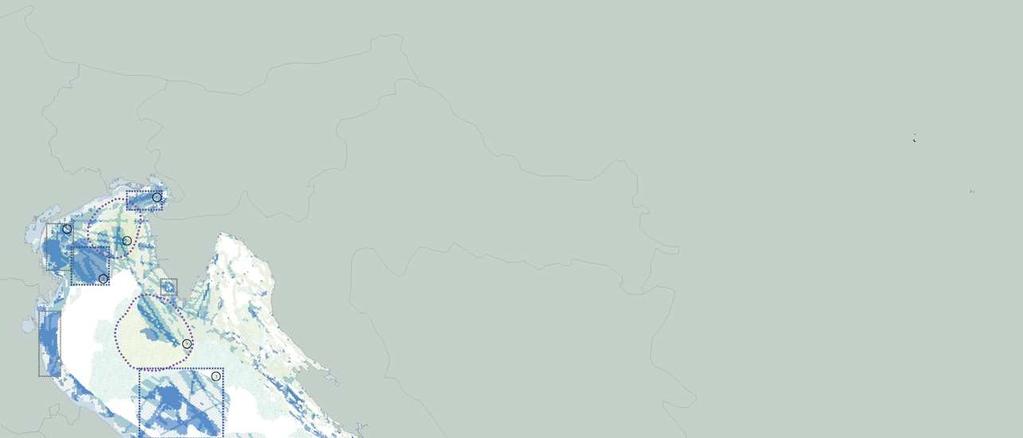
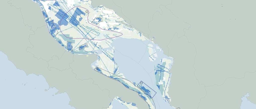
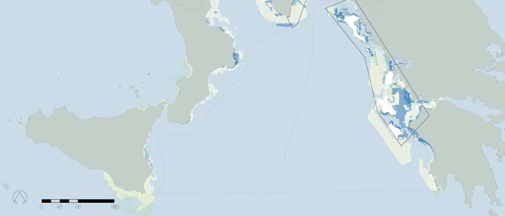
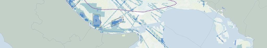
11 ADRIPLAN pre-planning: geographical scope and boundaries Establishing boundaries for cross-border MSP considering jurisdictions
12 ADRIPLAN methodology Pre-planning
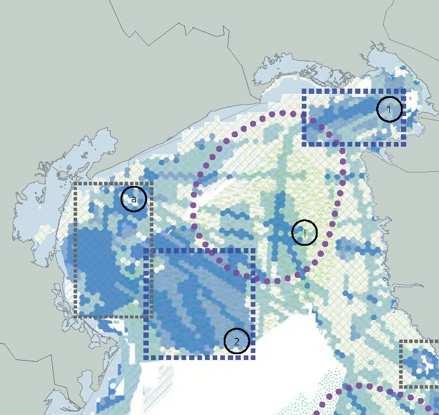
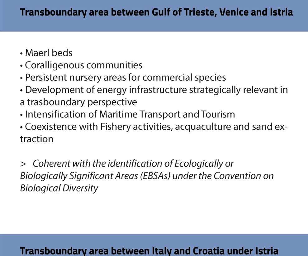
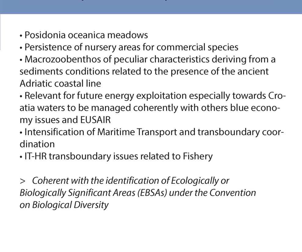
13 ADRIPLAN methodology analysis Pivotal uses Environmental components
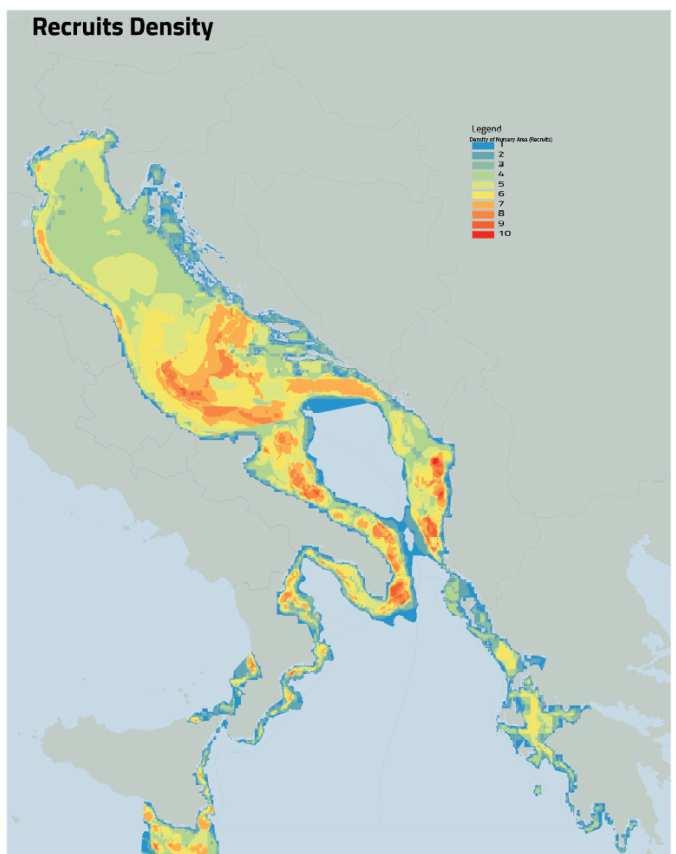
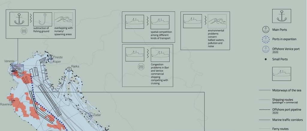
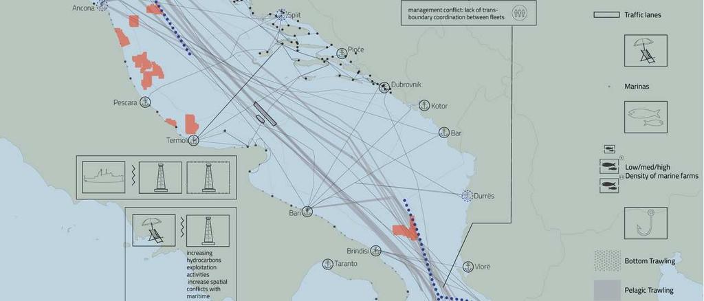
14 ADRIPLAN methodology coexistence among uses Analysis of most intensively used maritime areas, with coexistence in space and time Baseline: 2014, Future scenario: 2020

 - Future projections of maritime uses are not")
15 ADRIPLAN methodology coexistence among uses Analysis of most intensively used maritime areas, with coexistence in space and time Baseline: 2014, Future scenario: 2020 Main findings - Identificationof transboundaryareaswith potential conflicts in space and time - Differencesare visiblebetweenterritorialand high waters - Resultsobtainedare strictlydependenton data collected(and gaps) - Future projections of maritime uses are not always spatially explicitly
16 ADRIPLAN methodology cumulative impacts Analysis of cumulative impacts on marine environmental components deriving from maritime uses and related pressures Baseline: 2014, Future scenario: 2020
 - 28 Environmental components -16 Maritime Uses - 18")
17 ADRIPLAN methodology cumulative impacts Analysis of cumulative impacts on marine environmental components deriving from maritime uses and related pressures Baseline: 2014, Future scenario: 2020 Sensitivity analysis through Expert opinion (298 answers) - 28 Environmental components -16 Maritime Uses - 18 Pressures(from MSFD)
18 ADRIPLAN methodology cumulative impacts Analysis of cumulative impacts on marine environmental components deriving from maritime uses and related pressures Baseline: 2014, Future scenario: 2020 Main findings - Impactsdependon the distributionof EnvironmentalComponents whichare sensitive to Maritime Uses - Notallmarine areasare impactedin the same way (hotspots of impacts) - The geometryof the resultsdependson the input data of the analysis(maritimeuses, environmental components) - Improvements to overcome data gaps demand for science - Involvementof expertson the entireaim asa key challenge
19 ADRIPLAN methodology- interpretation Pre-planning
20 ADRIPLAN methodology- interpretation v Strategic proposal for AIM v Pilot actions at Focus Area Level
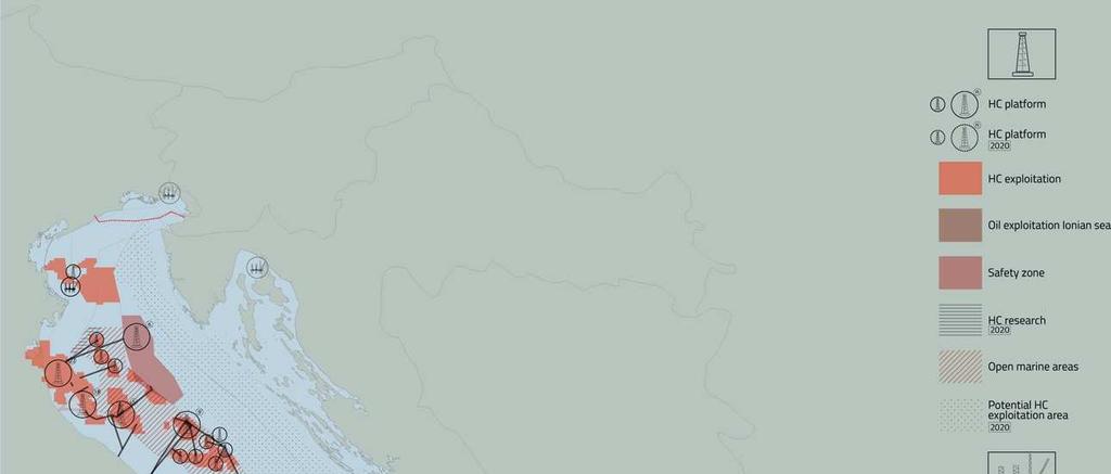
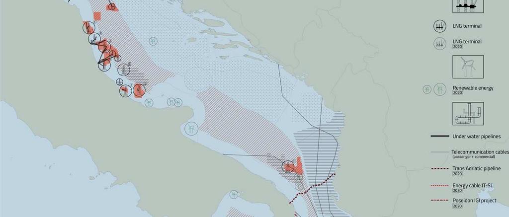

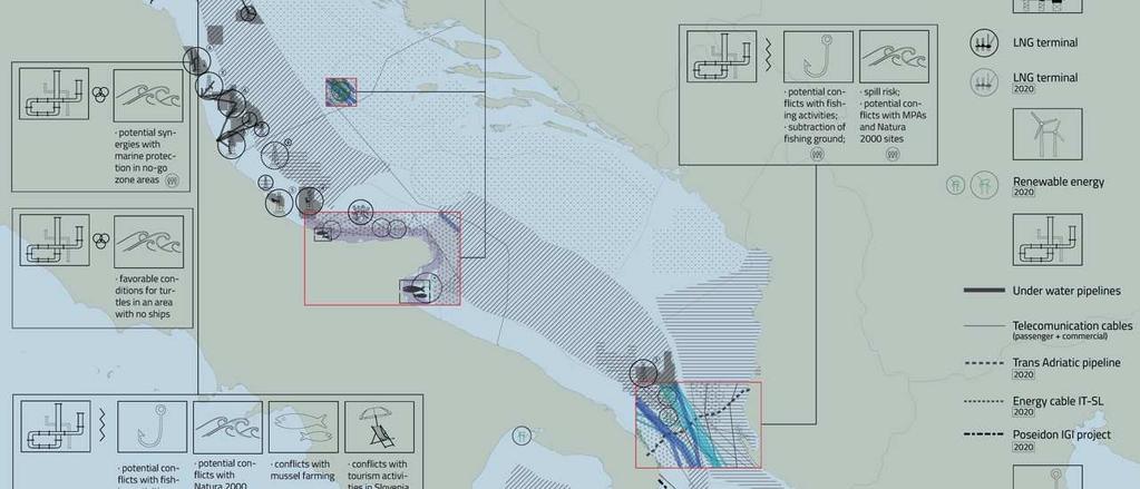
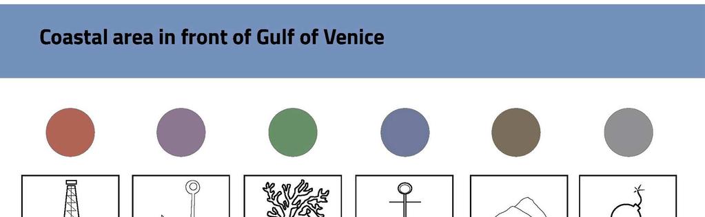
21 Energy interpretation from pivotal uses INTERPRETATION ANALYSIS
22 Energy interpretation from pivotal uses INTERPRETATION: focus
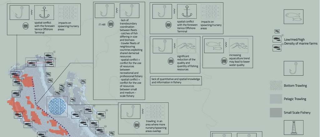

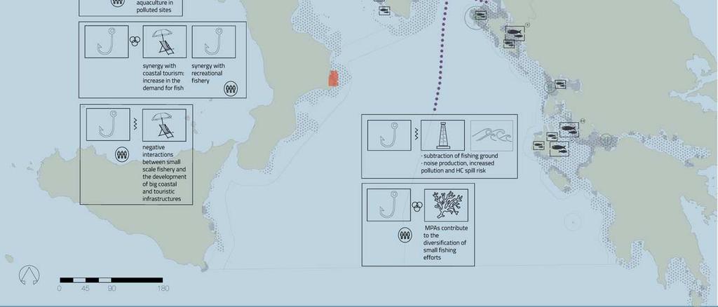
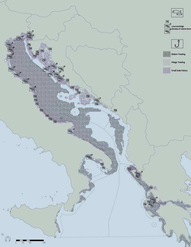
23 Fishery&Aquaculture interpretation from pivotal uses INTERPRETATION ANALYSIS
24 Fishery&Aquaculture interpretation from pivotal uses INTERPRETATION: focus
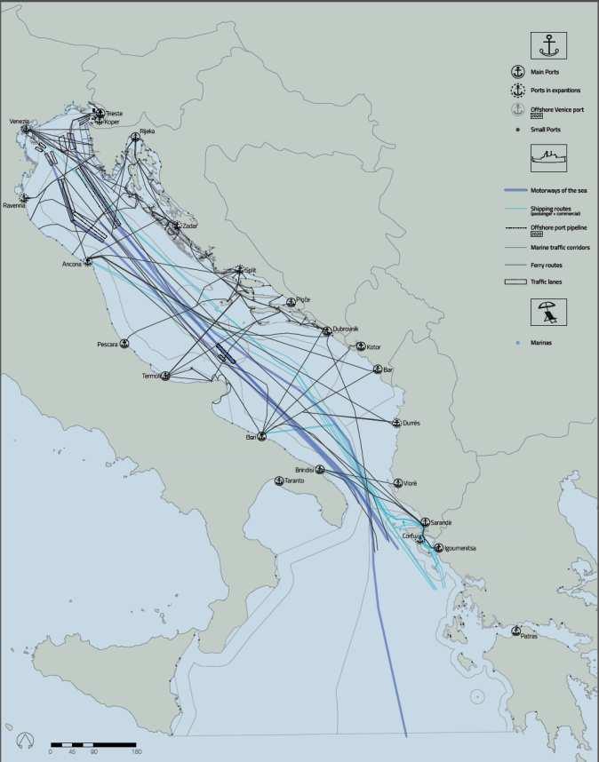
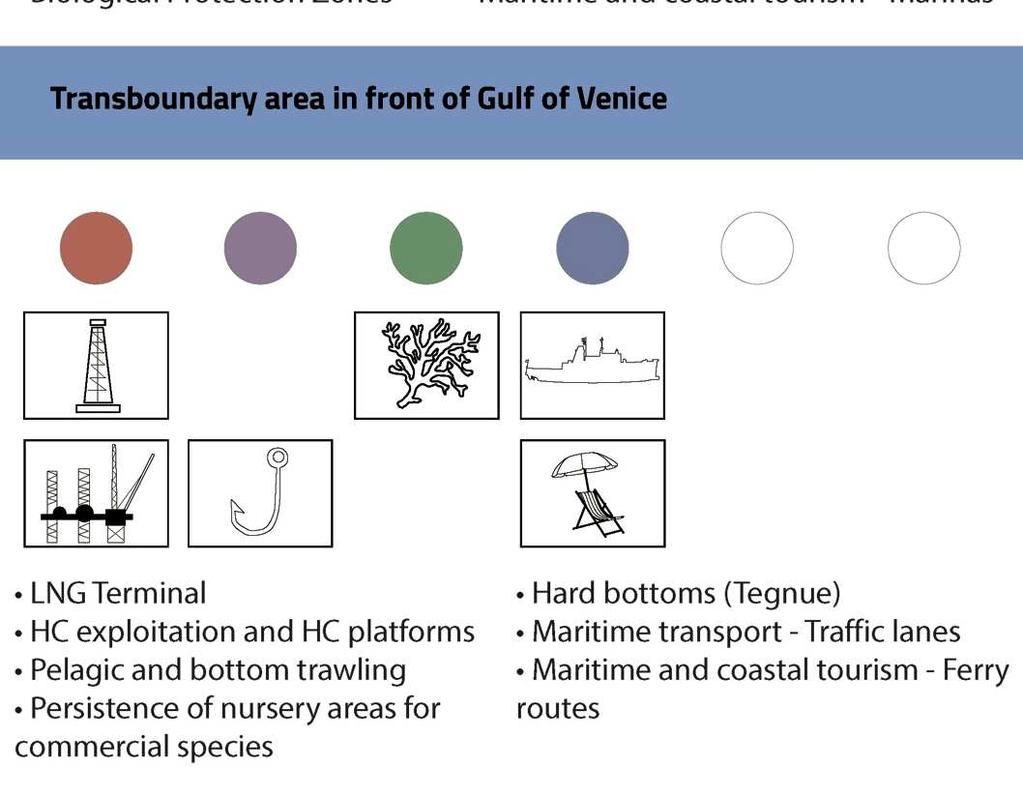
25 Maritime Transport&Tourism interpretation from pivotal uses INTERPRETATION ANALYSIS


26 Maritime Transport&Tourism interpretation from pivotal uses INTERPRETATION: focus
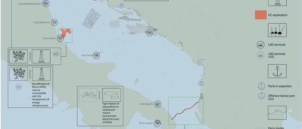
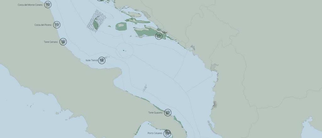
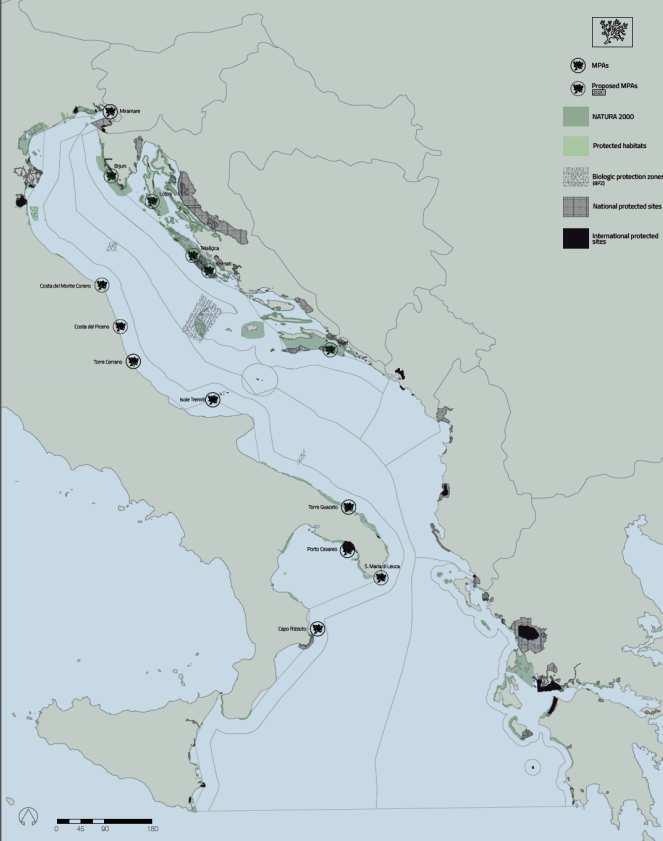
27 Environmental protection interpretation from pivotal uses INTERPRETATION ANALYSIS
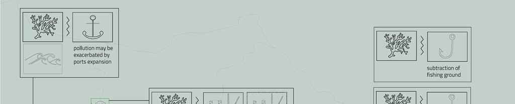

28 Environmental protection interpretation from pivotal uses INTERPRETATION
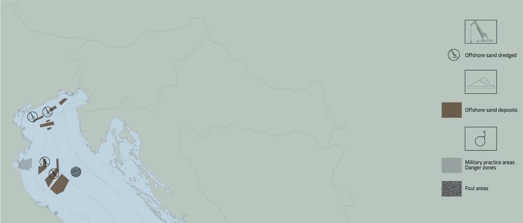
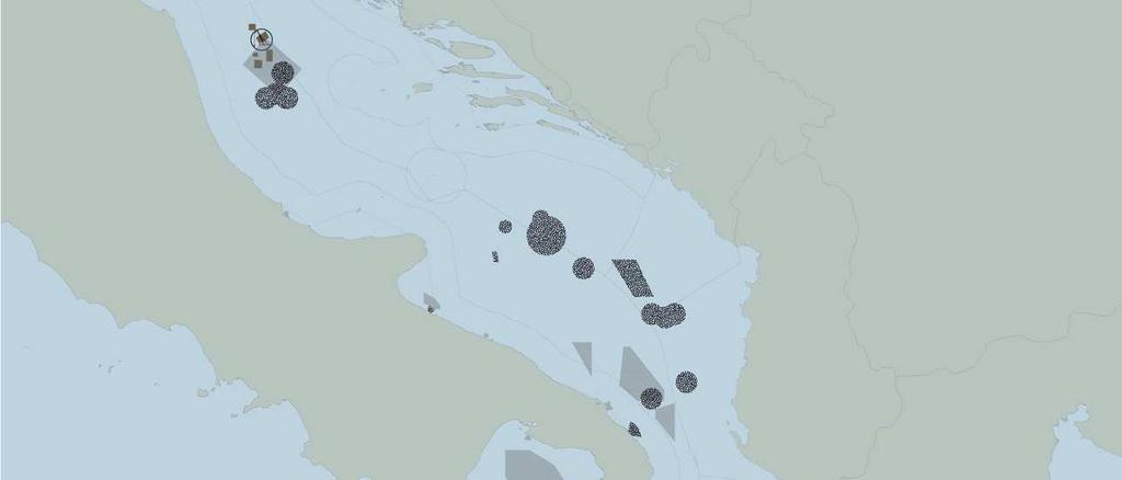
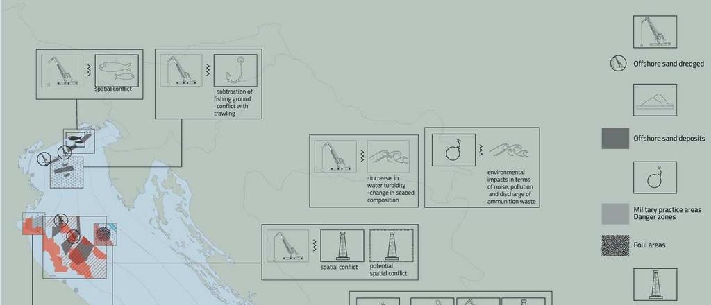
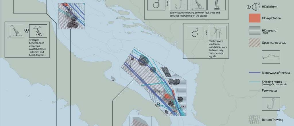
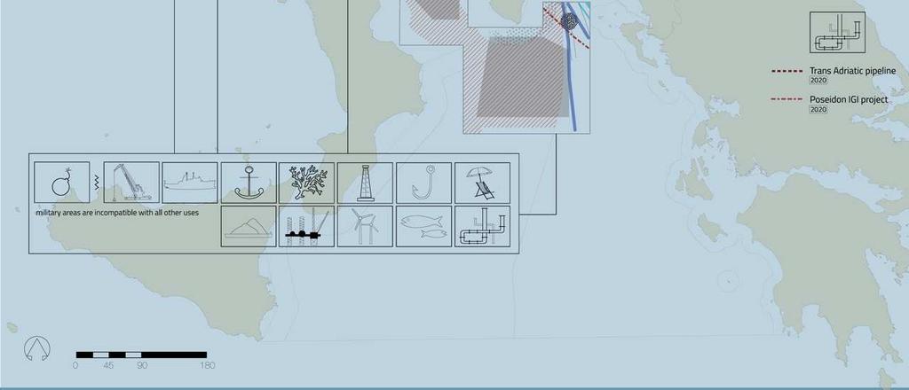
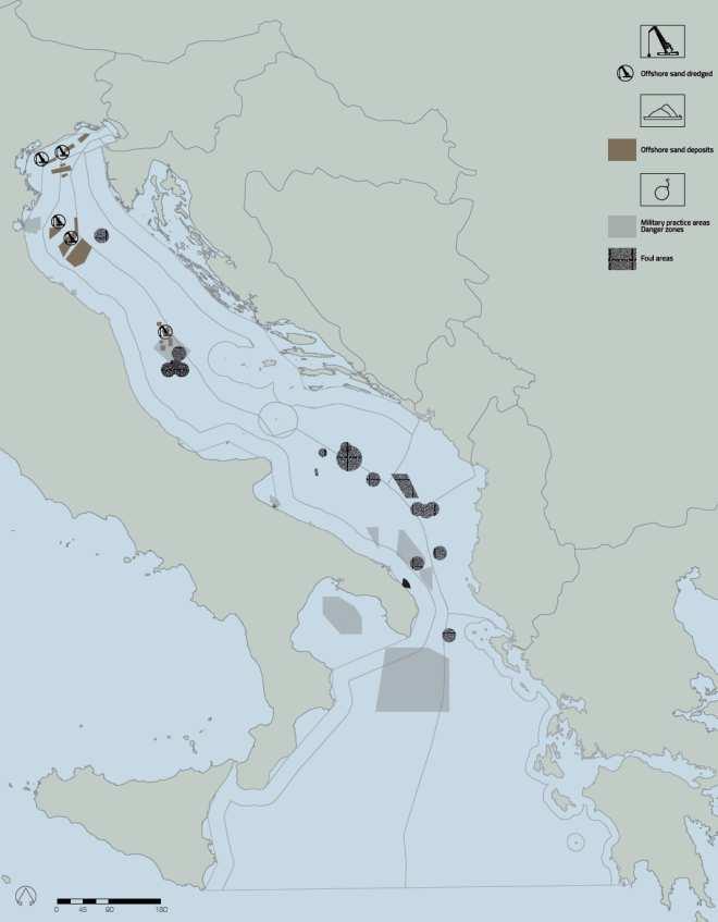
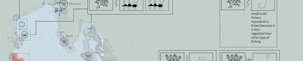
29 Sand extraction& military areas interpretation from pivotal uses INTERPRETATION ANALYSIS


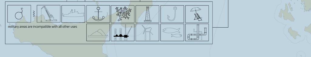
30 Sand extraction& military areas interpretation from pivotal uses INTERPRETATION
31 ADRIPLAN methodology Pre-planning


32 DESIGN STRATEGIC PROPOSAL FOR THE AIM
33 Strategic proposal for the AIR Main issues - General goal isto supportthe implementationof Blue Growthobjectives, and specifically of EUSAIR & MSP accordingly Maritime Spatial Planning 2014/89/EU; - Considering primarily transboundary issues/trasboundary governance framework - Identification of different types of management areas, characterized by specific management objectivesreflectingon contextualuse-use and environment-use conditions and coexistences. Types of management areas - 1) Considerthe coexistenceof multiple maritimeusesin sensitive marine environments, high water, intensivelyused. Management optionsbasedon transboundary governance according future demand of space; - 2) Located in territorial waters, so the governance system should - consider National legal framework. Intensively used and with environmental challenges; - 3) areas which assume a great importance for the delivery of ecosystems goods and servicesfor the AIM
34


35


36
37 Final consideration A planning scheme for AIR - Introduction of MSP requires a strong commitments of regional and national government in the AIR - A strong interaction with local planning systems accordingly a transboundary perspective is fundamental; Some recomendations - Future mandate by the National and Regional authorities - Following with the implementation of European Directive on MSP - Msp process tailored accordinlgy to the legal framework and institutional mandate - Variable of planning intensity and scale

38 Thanks Credits: all the ADRIPLAN Team, in particular F.Musco and A. Barbanti
ADRIPLAN: an EU funded pilot project on MSP in the Adriatic Ionian Region Pierpaolo Campostrini CORILA and CNR-ISMAR
 ADRIPLAN: an EU funded pilot project on MSP in the Adriatic Ionian Region Pierpaolo Campostrini CORILA and CNR-ISMAR ADRiatic Ionian maritime spatial PLANning ADRIPLAN PROJECT ADRIPLAN has the objective
ADRIPLAN Project Prof. Francesco Musco, IUAV University of Venice
 ADRIPLAN Project Prof. Francesco Musco, IUAV University of Venice msp@iuav.it Riga, Baltic MSP Forum, 17/18 June 2014 Outline The ADRIPLAN Project (DG MARE) Methodological insights Planning Design & interaction
Mediteranean sea issues in the view of ESPON ESaTDOR project and Marine Spatial Planning in Slovenia
 DIREKTORAT ZA PROSTOR, GRADITEV IN STANOVANJA Mediteranean sea issues in the view of ESPON ESaTDOR project and Marine Spatial Planning in Slovenia BlueMed meeting of stakeholders on a micro-regional level
FROM DATA TO WISDOM: INFORMING MSP AND EUSAIR IMPLEMENTATION IN THE ADRIATIC IONIAN REGION
 FROM DATA TO WISDOM: INFORMING MSP AND EUSAIR IMPLEMENTATION IN THE ADRIATIC IONIAN REGION Alessandro Sarretta, Chiara Venier, Andrea Barbanti, Stefano Menegon, Daniel Depellegrin (CNR-ISMAR) alessandro.sarretta@ismar.cnr.it
Aquaculture Spatial Planning: The case of Greece
 Aquaculture Spatial Planning: The case of Greece Nikos Anagnopoulos Panhellenic Association for Small-Medium sized Aquaculture Enterprises Panhellenic Association for Small-Medium sized Aquaculture Enterprises
EUSAIR on sea topics from Slovenian perspective
 MINISTRY OF FOREIGN AFFAIRS REPUBLIC OF SLOVENIA EUSAIR on sea topics from Slovenian perspective Mag. Andreja Jerina National Coordinator 4 EU MRS: 270 millions of population 19 MS 12 non MS Sea basin
CONCEPTUAL FRAMEWORK FOR MARINE SPATIAL PLANNING IN THE MEDITERRANEAN
 CONCEPTUAL FRAMEWORK FOR MARINE SPATIAL PLANNING IN THE MEDITERRANEAN CONCEPTUAL FRAMEWORK FOR SPATIAL PLANNING IN THE MEDITERRANEAN LEGAL NOTICE The designations employed and the presentation of the material
Mediterranean Sea and Territorial Development, Opportunities and Risks
 EESC Hearing Towards an EU Macro-Regional Strategy for the Mediterranean Mediterranean Sea and Territorial Development, Opportunities and Risks Michaela Gensheimer Structure of Intervention Part I: What
MODELS AND TOOLS FOR GOVERNANCE OF
 Working Papers Collection No. 1/2015 MODELS AND TOOLS FOR GOVERNANCE OF THE ADRIATIC AND IONIAN SEAS www.unimc.it/maremap NATIONAL POLITICS AND EU POLITICS: THE MARITIME SPATIAL PLANNING AND INTEGRATED
Outline National legislative & policy context Regional history with ESSIM ESSIM Evaluation Phase Government Integration via RCCOM Regional ICOM Framew
 What MSP Implementation could change in the Maritimes Region Tim Hall, Regional Manager Oceans and Coastal Management Division Ecosystem Management Branch Fisheries and Oceans Canada Maritimes Region BIO
Maritime Spatial Planning: Transboundary Cooperation in the Celtic Seas Looking Ahead
 Maritime Spatial Planning: Transboundary Cooperation in the Celtic Seas Looking Ahead Looking ahead MSP in the context of the European Maritime and Fisheries Fund (EMFF) and beyond SIMCelt Final Conference
National Perspectives - Portugal. Margarida Almodovar
 National Perspectives - Portugal Margarida Almodovar margarida.almodovar@mam.gov.pt from base line to the external limit of the continental shelf behind 200 miles and according to UNCLOS definitions Economic
Maritime Spatial Planning in the Baltic Sea Region
 Maritime Spatial Planning in the Baltic Sea Region Past, present, perspective Talis Linkaits VASAB Secretariat XIX International Environmental Forum 22 March 2018, Saint Petersburg A cooperation of ministers
1. Baltic SCOPE Towards coherence and cross-border solutions in Baltic Maritime Spatial Plans
 NSHC 32th Conference Explanatory Note Dublin, Ireland Item E.2 MSP 21-23 June 2016 Germany Cross border MSP for the EEZ, a case study from the Baltic Sea The Federal Maritime and Hydrographic Agency of
Croatian physical planning system and strategic approach to MSP
 W 1/7 Past two years all over the Europe: case studies 2 Croatian physical planning system and strategic approach to MSP Vesna Marohnić Kuzmanović Head of Department Croatian Institute for Spatial Development
Integrated Strategies in regional development
 Inspire policy making by territorial evidence ESPON Seminar Territories Acting for Economic Growth: Using territorial evidence to meet challenges towards 2020 Integrated Strategies in regional development
SPLAN-Natura Towards an integrated spatial planning approach for Natura th January, 2017 Brussels. Commissioned by DG Environment
 SPLAN-Natura 2000 Towards an integrated spatial planning approach for Natura 2000 Commissioned by DG Environment 17 th January, 2017 Brussels V. Simeonova (Ph.D.) Drivers towards integrating Biodiversity
Marine/Maritime Spatial Planning Andrej Abramić
 Marine/Maritime Spatial Planning Andrej Abramić EcoAqua SUMMER SCHOOL: Ecosystem approach to aquaculture 26-29th of October 2015 Research and Technology to enhance excellence in Aquaculture development
Towards coherent maritime spatial planning in the Baltic Sea Region, transnational and project perspective Talis Linkaits Head of VASAB Secretariat
 3 June 2013 Riga PartiSEApate Workshop MSP as Tool for Underwater Cultural Heritage Management in the Baltic Sea Towards coherent maritime spatial planning in the Baltic Sea Region, transnational and project
SIMCelt Supporting Implementation of Maritime Spatial Planning in the Celtic Seas. Patrice Laporte
 SIMCelt Supporting Implementation of Maritime Spatial Planning in the Celtic Seas Patrice Laporte patrice.laporte@shom.fr General background In July 2014 the EU adopted a directive establishing a framework
Findings and recommendations from Central Baltic case
 W 1/1 Recommendations on transboundary planning from Baltic SCOPE Findings and recommendations from Central Baltic case Ingūna Urtāne Director of Spatial Planning Department of the Ministry of Environmental
The Process of Spatial Data Harmonization in Italy. Geom. Paola Ronzino
 The Process of Spatial Data Harmonization in Italy Geom. Paola Ronzino ISSUES Geospatial Information in Europe: lack of data harmonization the lack of data duplication of data CHALLENGES Challenge of INSPIRE:
ICZM and MSP in the Black Sea Region
 ICZM and MSP in the Black Sea Region Drd. Claudia Coman, Environmental engineer AG ICZM Focal Point, Romania Black Sea Commission Black Sea Commission on the Protection of the Black Sea against Pollution
Maritime Spatial Planning in the Baltic Sea Region
 Maritime Spatial Planning in the Baltic Sea Region Talis Linkaits Head of VASAB Secretariat 20 May 2015 Helsinki A cooperation of ministers of the 11 Baltic Sea Region countries responsible for spatial
Country Fiche Estonia
 Country Fiche Estonia Updated October 2017 1. General information Size of internal waters (to the baseline) and territorial sea (12-nm zone from the baseline) approximately 25 200 km 2. Exclusive economic
Natura 2000 and spatial planning. Executive summary
 Natura 2000 and spatial planning Executive summary DISCLAIMER The information and views set out in this study are those of the author(s) and do not necessarily reflect the official opinion of the Commission.
Marine Spatial Planning in Hellas; Recent Facts and Perspectives
 XXV FIG CONGRESS Engaging the Challenges, Enhancing the Relevance Kuala Lumpur, Malaysia 16 21 June 2014 Marine Spatial Planning in Hellas; Recent Facts and Perspectives Mrs. Chaiditsa BOLANOU Surveying
Country Fiche Estonia
 Country Fiche Estonia Deleted: October Updated May 2018 Deleted: 7 1. General information Size of internal waters (to the baseline) and territorial sea (12-nm zone from the baseline) approximately 25 200
2012 FORUM OF MARINE PROTECTED AREAS IN THE MEDITERRANEAN ANTALYA, TURKEY
 2012 FORUM OF MARINE PROTECTED AREAS IN THE MEDITERRANEAN ANTALYA, TURKEY SPECIAL EVENT Challenges for Open Seas MPAs in the Mediterranean region November 27, 2012. 15h00-16H00 Slide # 1 2012 FORUM OF
Natura 2000 in the marine environment: state of implementation and next steps
 Life on the blue planet: biodiversity research and the new European marine policies EPBRS European Platform on Biodiversity Research Strategy Porto, Portugal 7-9 November 2007 Natura 2000 in the marine
Emerging tensions between blue growth and good environmental status
 Emerging tensions between blue growth and good environmental status Dr Peter Jones, Reader in Environmental Governance, Dept of Geography, University College London www.bnycharters.com Slides @PJSJones
Country Fiche Lithuania
 Country Fiche Lithuania Updated June 2018 1. General information The Lithuanian maritime space is delimited by the Decree of the Government of the Republic of Lithuania of 6 December, 2004, No. 1597 and
MR. George ALEXAKIS, parallel session 3. "Mediterranean Sea Region. laying the conditions. for sustainable growth and jobs"
 parallel session 3 "Mediterranean Sea Region laying the conditions for sustainable growth and jobs" MR. George ALEXAKIS, elected Regional Councillor of Crete, Greece and representative of Crete in CRPM.
ESPON support for Targeted Analyses Ilona Raugze Director
 ESPON support for Targeted Analyses Ilona Raugze Director ESPON EGTC 14 November 2017 ESPON EGTC workshop Targeted Analysis in support of better policy making in cities and regions Inspire policy making
Experiences of public-private partnerships in the Euromediterranean relations and in the Po Valley, promoting a more balanced European territory
 Experiences of public-private partnerships in the Euromediterranean relations and in the Po Valley, promoting a more balanced European territory Claudio Tolomelli PolyMetrexPlus project s objectives To
Country reports. Israel did not establish an Exclusive Economic Zone. Consequently, its jurisdiction is restricted to the Israeli territorial waters.
 Country reports I. ISRAEL Disclaimer This document has not been adopted by the European Commission and should therefore not be relied upon as a statement of the European Commission. The purpose of this
Open source tools to support Integrated Coastal Management and Maritime Spatial Planning
 Open source tools to support Integrated Coastal Management and Maritime Spatial Planning Stefano Menegon 1, Alessandro Sarretta 1, Andrea Barbanti 1, Elena Gissi 2, and Chiara Venier 1 1 Consiglio Nazionale
This document has been verified by the responsible MSP authority (or representative) of Slovenia on
 of Slovenia on") Contacts MSP National Level Lenča Humerca Šolar Ministry of the Environment and Spatial Planning Dunajska 48, SI - 1001 Ljubljana, Slovenia E-mail: lenca.humerca-solar@gov.si Phone: + 386 1 478 7400 Website:
Contacts MSP National Level Lenča Humerca Šolar Ministry of the Environment and Spatial Planning Dunajska 48, SI - 1001 Ljubljana, Slovenia E-mail: lenca.humerca-solar@gov.si Phone: + 386 1 478 7400 Website:
Slovenia. Maritime Spatial Planning Country Information. Slovenia.
 Slovenia Maritime Spatial Planning Country Information Slovenia The European MSP Platform is financed by the EU Commission under the EMFF Workprogrammes 2014 and 2015. The European MSP Platform is a result
MARINE SPATIAL PLANNING & MARINE CADASTRE: CHALLENGES AND ISSUES
 MARINE SPATIAL PLANNING & MARINE CADASTRE: CHALLENGES AND ISSUES Roger Longhorn Secretary General, GSDI Association rlonghorn@gsdi.org Member, IHO Marine SDI Working Group ral@alum.mit.edu Member, UNESCO
Baltic Sea Region cooperation in Maritime Spatial Planning - HELCOM/VASAB
 Baltic Sea Region cooperation in Maritime Spatial Planning - HELCOM/VASAB Sten Jerdenius Swedish Ministry of the Environment HELCOM/VASAB MSP Group Baltic Sea Region subregional workshop Espoo 31 March
Country Fiche Latvia Updated October 2016
 Country Fiche Latvia Updated October 2016 1. General information Marine area under Latvian jurisdiction includes inland sea waters, Territorial sea (12 nautical miles from the baseline) and exclusive economic
Launch of the ESPON 2013 Programme. European observation network on territorial development and cohesion
 Launch of the ESPON 2013 Programme European observation network on territorial development and cohesion Framework conditions for the ESPON 2013 Programme Policy development in use of territorial evidence
PLAN BOTHNIA MARE/2009/16
 PLAN BOTHNIA MARE/2009/16 Hermanni Backer Project Manager HELCOM Secretariat Partner Kick-Off Meeting Nordregio, Stockholm December 16 2010 Photo: Elena Bulycheva PLAN BOTHNIA MARE/2009/16 Co-financed
Introduction to IMP: need and added value
 Introduction to IMP: need and added value Christophe Le Visage Consultant Stratégies Mer et Littoral 1 Summary IMP : Why? The case for integration 1 What is IMP? 2 Content, process IMP: Added Value 3 2
THE ROLE OF SPATIAL PLANNING IN INTEGRATED COASTAL ZONE MANAGEMENT RECOMMENDATIONS FROM THE INTERREG III B BALTCOAST PROJECT
 THE ROLE OF SPATIAL PLANNING IN INTEGRATED COASTAL ZONE MANAGEMENT RECOMMENDATIONS FROM THE INTERREG III B BALTCOAST PROJECT DISCUSSION PAPER FOR THE TRANSNATIONAL WORKING GROUP DECEMBER 2004 CONTENT 1.
ESPON 2020 Cooperation Programme. Anneloes van Noordt MC-member Belgium
 ESPON 2020 Cooperation Programme Anneloes van Noordt MC-member Belgium Anneloes.vannoordt@vlaanderen.be Outline ESPON 2020 Cooperation Programme Applied Research Targeted Analysis Database & Tools Outreach
Biodiversity and Protected Areas Management Project
 Biodiversity and Protected Areas Management Project Technical Advisor ESA region: Selwyn Willoughby Coordinator ESA region: Christine Mentzel FlexiCadastre EMEA Regional User Conference, Cape Town, South
The Baltic Sea Region Maritime Spatial Planning Data Expert Sub-group. First Report 2015/2016/
 The Baltic Sea Region Maritime Spatial Planning Data Expert Sub-group First Report 2015/2016/2017 21.04.2017. Contents 1. Glossary 2 2. Introduction. 3 3. MSP Data. 5 3.1. Input Data. 5 3.2 Output Data.
Marine Spatial Planning: A Tool for Implementing Ecosystem-Based Management
 Marine Spatial Planning: A Tool for Implementing Ecosystem-Based Management Steven Murawski, Ph.D., Ecosystem Goal Team Lead National Oceanic and Atmospheric Administration NOAA November 16, 2009 1 To
Marine Spatial Planning in the Baltic Sea Region
 Marine Spatial Planning in the Baltic Sea Region Towards coherence and cross-border solutions in Baltic Maritime Spatial Plans Coordinator & Project manager Dr Ingela Isaksson Swedish Agency for Marine
MSP in the Adriatic: problem and opportunity analysis, thematic mapping and inputs for a future
 MSP in the Adriatic: problem and opportunity analysis, thematic mapping and inputs for a future vision Action 4.3 Final Report 10 February 2014 External Expert: Thetis S.p.A. Committente: Regione Veneto
Maritime Spatial Planning
 Maritime Spatial Planning The Dutch experience Kopenhagen 28 november 2012 Lodewijk.Abspoel@minienm.nl North Sea 2 Outline History of MSP in the Netherlands Spatial Plan for the Dutch EEZ, principles and
BURGAS CASE STUDY: LAND-SEA INTERACTIONS
 BURGAS CASE STUDY: LAND-SEA INTERACTIONS Dr. Margarita Stancheva IO-BAS, Bulgaria Name of presentation CROSS BORDER MARITIME SPATIAL PLANNING IN THE BLACK SEA ROMANIA AND BULGARIA (MARSPLAN BS) Project
BURGAS CASE STUDY: LAND-SEA INTERACTIONS. Dr. Margarita Stancheva
 BURGAS CASE STUDY: LAND-SEA INTERACTIONS Dr. Margarita Stancheva Name of presentation NEED FOR COHERENCE BETWEEN LAND AND SEA ACTIVITIES Name presenter Burgas is the fourth largest city in Bulgaria and
DELIVERING ECOSYSTEM- BASED MARINE SPATIAL PLANNING IN PRACTICE
 DELIVERING ECOSYSTEM- BASED MARINE SPATIAL PLANNING IN PRACTICE A first assessment for the UK and Ireland January 08 GLOBAL WARMING IMAGES / WWF ABOUT WWF WWF is the world s leading independent conservation
Recommendation on how to perform analysis of land-sea interactions, combining MSP and ICZM in the considered project area
 Recommendation on how to perform analysis of land-sea interactions, combining MSP and ICZM in the considered project area Initial definitions Deliverable No 1.3.7 Co-funded by the European Maritime and
16540/14 EE/cm 1 DG E 1A
 Council of the European Union Brussels, 5 December 2014 (OR. en) 16540/14 ENV 965 CULT 139 NOTE From: To: Subject: General Secretariat of the Council Delegations Charter of Rome on Natural and Cultural
geoporrtal of Tools & Data for sustainable Management of coastal and marine Environment (ADRION205)
") PORTODIMARE geoporrtal of Tools & Data for sustainable Management of coastal and marine Environment (ADRION205) Minutes of the PORTODIMARE International Conference on ICZM&MSP 11/2018 Page 1 PORTODIMARE
PORTODIMARE geoporrtal of Tools & Data for sustainable Management of coastal and marine Environment (ADRION205) Minutes of the PORTODIMARE International Conference on ICZM&MSP 11/2018 Page 1 PORTODIMARE
Ensuring Access to Marine Areas for Offshore Oil and Gas
 Ensuring Access to Marine Areas for Offshore Oil and Gas Paul Holthus Executive Director World Ocean Council paul.holthus@oceancouncil.org The international business alliance for Corporate Ocean Responsibility
Stepping into the sea - New evidence on territorial development and the opportunities and risks for European seas and maritime regions
 ESPON 2013 Programme Workshop Stepping into the sea - New evidence on territorial development and the opportunities and risks for European seas and maritime regions 15 May 2013 9h00 16h30 Venue The Norwegian
Evaluation of Spatial Planning as a Tool for Integrated Marine Management Status, Obstacles and Research Gaps
 Evaluation of Spatial Planning as a Tool for Integrated Marine Management Status, Obstacles and Research Gaps Baltic MSP Forum Riga 17.-18. June 2014 A. Morf & A. Grimvall: Swedish Institute for the Marine
Margarita Stancheva Hristo Stanchev & Robert Young 2. MEDCOAST JUBILEE WORKSHOP May 2015, Iberotel Sarigerme Park, Dalaman, Turkey
 Margarita Stancheva Hristo Stanchev & Robert Young 2 INTRODUCTION: Bulgarian Black Sea coast INTRODUCTION: Increasing pressure on Bulgarian coastal zone In 2011, of the 7 364 570 people that lived in Bulgaria,
Coastal Mapping Follow on? Bruno Frachon Corine Lochet Gaël Morvan
 Coastal Mapping Follow on? Bruno Frachon Corine Lochet Gaël Morvan Shared objectives; IHO DG MARE CPMR Development of a Joint European Coastal Mapping Programme (JECMaP) within the IHO EU network with
Implementation of the Political Declaration on energy cooperation between the North Seas Countries. Support Group 1 on Maritime Spatial Planning
 Implementation of the Political Declaration on energy cooperation between the North Seas Countries Support Group 1 on Maritime Spatial Planning Work Programme 1. Work area as outlined in Annex I to the
SPIMA Spatial dynamics and strategic planning in metropolitan areas
 Targeted Analysis SPIMA Spatial dynamics and strategic planning in metropolitan areas Executive Summary Conference version 1 February 2018 0 1. Background To address the challenges of metropolitan development
Marine Spatial Planning (MSP): A practical approach to ecosystembased
: A practical approach to ecosystembased") Marine Spatial Planning (MSP): A practical approach to ecosystembased management Erik Olsen, Institute of Marine Research, Norway Fanny Douvere, International Oceanographic Commission Overview Why we need
Marine Spatial Planning (MSP): A practical approach to ecosystembased management Erik Olsen, Institute of Marine Research, Norway Fanny Douvere, International Oceanographic Commission Overview Why we need
ESPON SEMINAR «WHERE ARE EUROPEAN CITIES HEADING? EVIDENCE FOR BETTER POLICY-MAKING» 7-8 DECEMBER BRATISLAVA
 ESPON SEMINAR «WHERE ARE EUROPEAN CITIES HEADING? EVIDENCE FOR BETTER POLICY-MAKING» 7-8 DECEMBER 2016 - BRATISLAVA The Region of Abruzzo: facts & figures Total surface: 1.079.512 Ha; Mountains in Abruzzo
Marine Spatial Planning as an important tool for implementing the MSFD
 Marine Spatial Planning as an important tool for implementing the MSFD Risto Kalliola Tallinn, Nov. 16 th 2012 DEPARTMENT OF GEOGRAPHY AND GEOLOGY University of Turku, Finland Ten principles to provide
Management Planning & Implementation of Communication Measures for Terrestrial Natura 2000 Sites in the Maltese Islands Epsilon-Adi Consortium
 Management Planning & Implementation of Communication Measures for Terrestrial Natura 2000 Sites in the Maltese Islands Epsilon-Adi Consortium Briefing Meetings, February 2013 CT3101/2011, MEPA, Malta
r i l:!n::5 ] F i n a l Repo rt Coas ta l Zon e Managemen t ( I CZM )
![r i l:!n::5 ] F i n a l Repo rt Coas ta l Zon e Managemen t ( I CZM )](/thumbs/94/122218329.jpg "r i l:!n::5 ] F i n a l Repo rt Coas ta l Zon e Managemen t ( I CZM )") C l i e n t : Eu ropean Com m iss ion - DG Env i ron men t S u bj e ct : An a lys is of Mem be r Sta tes p rog ress repo rts on I n teg rated Coas ta l Zon e Managemen t ( I CZM ) D o c. t i t l e : F
C l i e n t : Eu ropean Com m iss ion - DG Env i ron men t S u bj e ct : An a lys is of Mem be r Sta tes p rog ress repo rts on I n teg rated Coas ta l Zon e Managemen t ( I CZM ) D o c. t i t l e : F
This document has been verified by the responsible MSP authority (or representative) of Lithuania on
 of Lithuania on") Contact MSP in general Ms. Algimantė Treinienė Head of Spatial Planning Urban Development and Architecture Division Construction and Territorial Planning Department Ministry of Environment A. Jakšto 4
Contact MSP in general Ms. Algimantė Treinienė Head of Spatial Planning Urban Development and Architecture Division Construction and Territorial Planning Department Ministry of Environment A. Jakšto 4
FINDINGS OF THE ARCTIC METEOROLOGY SUMMIT
 FINDINGS OF THE ARCTIC METEOROLOGY SUMMIT 2018 WWW.FMI.FI CHAIR S SUMMARY: 1 2 3 We need to be curious to explore the known unknowns. Meteorology is an elemental part of international collaboration in
The National Spatial Strategy
 Purpose of this Consultation Paper This paper seeks the views of a wide range of bodies, interests and members of the public on the issues which the National Spatial Strategy should address. These views
EA SEA-WAY Project. 7 th Coordination Meeting. WP5 Development of sustainable passenger transport models for the Adriatic basin and capacity building
 EA SEA-WAY Project 7 th Coordination Meeting WP5 Development of sustainable passenger transport models for the Adriatic basin and capacity building 3 rd Cross Border Board Ravenna, January 26, 2016 The
Strategic Environmental Assessment / Environmental Impact Assessment
 Contacts MSP National Level Zrinka Sindler Ministry of Construction and Physical Planning Head of Department Ph.: +385 1 3712747 E-mail: zrinka.sindler@mgipu.hr Sandra Momcilovic Ministry of Construction
Tackling MSP integration challenges in the BSR
 Towards sustainable governance of Baltic marine space 2015 2018 BALTSPACE Towards sustainable governance of Baltic marine space Tackling MSP integration challenges in the BSR Michael Gilek, Södertörn University,
Possibilities for applying ES assessment results in spatial planning in Latvia
 Possibilities for applying ES assessment results in spatial planning in Latvia Inga Hoņavko LIFE EcosystemServices project manager LIFE Viva Grass seminar, Sigulda, 17.05.2018 Projekts LIFE EcosystemServices,
Maritime Spatial Planning Conference Addressing Land-Sea Interactions
 DIRECTORATE-GENERAL FOR MARITIME AFFAIRS AND FISHERIES Maritime Spatial Planning Conference Addressing Land-Sea Interactions St.Julian s, Malta 15-16 June 2017 #MSPLandSea Conference Report Maritime Spatial
Identification of maritime spatial planning best practices in the Baltic Sea Region and other EU maritime regions
 Identification of maritime spatial planning best practices in the Baltic Sea Region and other EU maritime regions PLAN BOTHNIA Baltic Sea Region Stakeholder Meeting Jacek Zaucha, Magdalena Matczak Two
A multilevel strategy for tourism development at regional level The case of the Marche Region
 Tourism and Biodiversity in Protected Areas 8th European Charter Network Meeting and Charter Awards (Brussels 6 november 2013) A multilevel strategy for tourism development at regional level The case of
PLAN BOTHNIA MSP 1/2011 PLAN BOTHNIA. PLAN BOTHNIA short description (document 3/1) PLAN BOTHNIA MSP 1 Pori, Finland, March
 PLAN BOTHNIA MSP 1 Pori, Finland, March") PLAN BOTHNIA Co-Financed Under European Integrated maritime Policy PLAN BOTHNIA short description (document 3/1) PLAN BOTHNIA MSP 1 Pori, Finland, March 7-8 2011 PLAN BOTHNIA MSP 1/2011 Agenda Item 3 Introduction
PLAN BOTHNIA Co-Financed Under European Integrated maritime Policy PLAN BOTHNIA short description (document 3/1) PLAN BOTHNIA MSP 1 Pori, Finland, March 7-8 2011 PLAN BOTHNIA MSP 1/2011 Agenda Item 3 Introduction
MARINE PLANNING IN THE NETHERLANDS
 MARINE PLANNING IN THE NETHERLANDS Hermien Busschbach Ministry of Transport, Public Works and Water Management (DG Water) Bremen, 2 May 2007 Marine Planning in the Netherlands OUTLINE policy context; international
POLISH LAW ON MSP. Andrzej Cieślak Maritime Office in Gdynia
 POLISH LAW ON MSP Andrzej Cieślak Maritime Office in Gdynia Preconditions Ownership/management of allsea areas (internal sea waters, territorial sea, EEZ): the State, and in its name the Minister responsible
Country Fiche Sweden Updated May 2018
 Country Fiche Sweden Updated May 2018 1. General information 2 the territorial sea (12-nm zone) 70,000 km2 the Exclusive Economic Zone 60,000 km2 the EEZ is limited to the central line between adjacent
EU HOs in Mediterranean and Black Sea (MBS) CROATIA FRANCE GREECE ITALY MALTA X SLOVENIA X SPAIN ROMANIA X
 CROATIA FRANCE GREECE ITALY MALTA X SLOVENIA X SPAIN ROMANIA X") EU HOs in Mediterranean and Black Sea (MBS) CROATIA FRANCE GREECE ITALY MALTA X SLOVENIA X SPAIN ROMANIA X Croatia Current status of hydrographic survey in acc. IHO C-55 pub. criteria Croatia Croatia by
EU HOs in Mediterranean and Black Sea (MBS) CROATIA FRANCE GREECE ITALY MALTA X SLOVENIA X SPAIN ROMANIA X Croatia Current status of hydrographic survey in acc. IHO C-55 pub. criteria Croatia Croatia by
Implementation of the ESPON 2020 cooperation program. 16 January 2017 Anneloes van Noordt
 Implementation of the ESPON 2020 cooperation program 16 January 2017 Anneloes van Noordt Outline! ESPON Cooperation Program! Specific Objectives! Applied Research! Targeted Analysis! Database & Tools!
Non-technical report
 Policy Research Corporation Non-technical report Exploring the potential of Maritime Spatial Planning in the Mediterranean Sea Framework contract FISH/2007/04 Specific contract No 6 February 2011 For the
Maritime Spatial Planning in Germany and Mecklenburg-Vorpommern
 Integrated Sea Use Planning Followings the Ecosystem Approach 2.10.08 Maritime Spatial Planning in Germany and Mecklenburg-Vorpommern by Helmuth von Nicolai Spatial Planning Department Ministry of Transport,
Marine Spatial Planning, a Norwegian user case NSHC33
 Marine Spatial Planning, a Norwegian user case NSHC33 Marine Spatial Management Tool Support the marine spatial planning process with updated and reliable geospatial information Marine management is important
The European territory: Strategic developmentd
 The European territory: Strategic developmentd Peter Mehlbye Workshop Strategic Development Catalonia 11 June 2002 THE LECTURE Structure I. Territorial trends II. Strategy for European spatial development
Metropolitan Areas in Italy
 Metropolitan Areas in Italy Territorial Integration without Institutional Integration Antonio G. Calafati UPM-Faculty of Economics Ancona, Italy www.antoniocalafati.it European Commission DG Regional Policy
Country Fiche Latvia.
 Country Fiche Latvia 1. General information Marine waters under Latvian jurisdiction include inland sea waters, territorial sea (12 nautical miles from the baseline) and exclusive economic zone (EEZ) waters.
PartiSEApate Conference
 Baltic Maritime Spatial Planning Forum PartiSEApate Conference C r e a t i n g c o m m o n u n d e r s t a n d i n g B a l t i c M a r i t i m e S p a t i a l P l a n n i n g F o r u m B a l t i c M a
MyCoast Elaboration of a vision and a strategy for Integrated Coastal Zone Management in Bulgaria
 1. NAME MyCoast Elaboration of a vision and a strategy for Integrated Coastal Zone Management in Bulgaria 2. DESCRIPTION 2.1 The case Bulgaria s coastal territory is distributed among three administrative
New Prospects for Peripheral Rural Regions Helmut Hiess Glasgow, 19th of May 2010
 New Prospects for Peripheral Rural Regions Helmut Hiess Glasgow, 19th of May 2010 ÖROK: Organisation & Tasks Austrian Conference on Spatial Planning (ÖROK, since 1971): Joint organisation by Federal level,
This document has been verified by the responsible MSP authority (or representative) of Cyprus on
 of Cyprus on") Contacts MSP National Level Ministry of Transport, Communications and Works Kyriacos Aliouris Department of Merchant Shipping Kyllinis street, Mesa Geitonia, 4007 LIMASSOL, Cyprus Ph.: +357 25848246 Mail:
Contacts MSP National Level Ministry of Transport, Communications and Works Kyriacos Aliouris Department of Merchant Shipping Kyllinis street, Mesa Geitonia, 4007 LIMASSOL, Cyprus Ph.: +357 25848246 Mail:
GLOBAL SYMPOSIUM ON SOIL ORGANIC CARBON, Rome, Italy, March 2017
 GLOBAL SYMPOSIUM ON SOIL ORGANIC CARBON, Rome, Italy, 21-23 March 2017 Strength and weaknesses of a bottom up approach in estimating soil organic carbon: an experience in the varied Italian scenery I.
GIS Geographical Information Systems. GIS Management
 GIS Geographical Information Systems GIS Management Difficulties on establishing a GIS Funding GIS Determining Project Standards Data Gathering Map Development Recruiting GIS Professionals Educating Staff
Iceland and the Arctic: The Politics of Territoriality. Valur Ingimundaron Professor of Contemporary History, University of Iceland
 Iceland and the Arctic: The Politics of Territoriality Valur Ingimundaron Professor of Contemporary History, University of Iceland Drivers of Icelandic Arctic Policies Geostrategic Position Economic Interests