ADRIPLAN: an EU funded pilot project on MSP in the Adriatic Ionian Region Pierpaolo Campostrini CORILA and CNR-ISMAR
|
|
|
- Annis Charles
- 6 years ago
- Views:
Transcription


1 ADRIPLAN: an EU funded pilot project on MSP in the Adriatic Ionian Region Pierpaolo Campostrini CORILA and CNR-ISMAR ADRiatic Ionian maritime spatial PLANning

2 ADRIPLAN PROJECT ADRIPLAN has the objective to promote transboundary Maritime Spatial Planning in the Adriatic Ionian Region. (December 2013 to July 2015) Budget: , 80% funded by the EC DG MARE The ADRIPLAN project develops proposals and recommendations for an operational cross-border MSP process which: allows the development of different maritime activities, preventing conflicts for space allocations, while ensuring a good status of the marine ecosystems provides greater confidence for investment in infrastructures and in other economic activities, responding to the peculiarities of each area fully involves relevant regional and governmental bodies and other relevant stakeholders, also promoting an effective cross-border cooperation enhances coherence between terrestrial and Maritime Spatial Planning, also in relation with good ICZM practices
3 ADRIPLAN Landscape BLUE GROWTH Ecosystem Based Management (Marine Strategy Dir., Water Framework Dir., Habitat & Birds Dir., etc.) Horizon 2020 Maritime Spatial Planning Directive ICZM Protocol Barcelona Convention EU Cohesion and Neighbourhood Policy (ENP) Macro-regional Strategies in the Mediterranean (i.e. EUSAIR) Integrated Maritime Policy


4 ADRIPLAN Partners CNR-ISMAR, Venice OGS, Trieste IUAV, Venice City of Rijeka Regional Development Centre Koper Conisma, Lecce University of Thessaly HCMR, Athens Emilia-Romagna Region Veneto Region Friuli Venezia Giulia Region Marche Region Molise Region Puglia Region Istria Region Ionian Islands Region Venice Port Authority

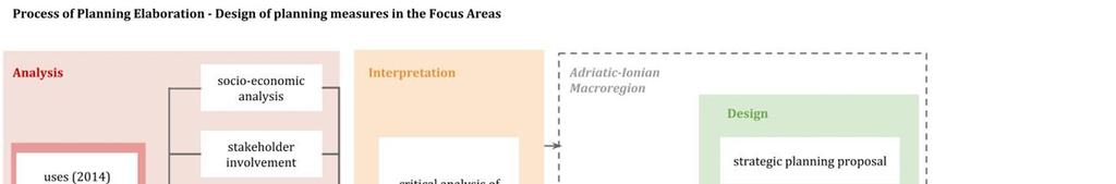
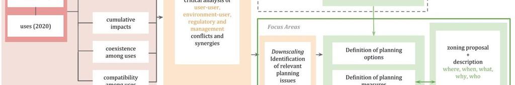
5 PROCESS OF PLANNING ELABORATION

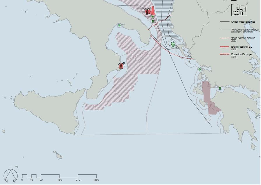
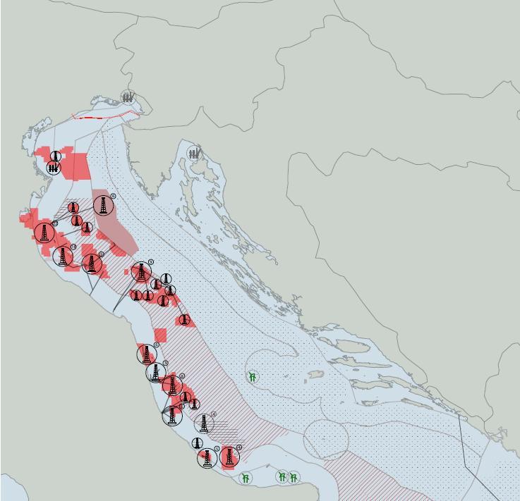
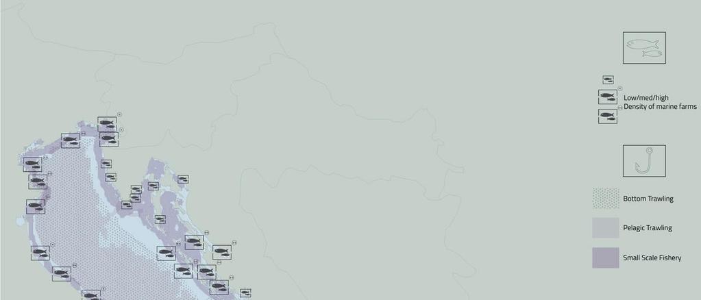
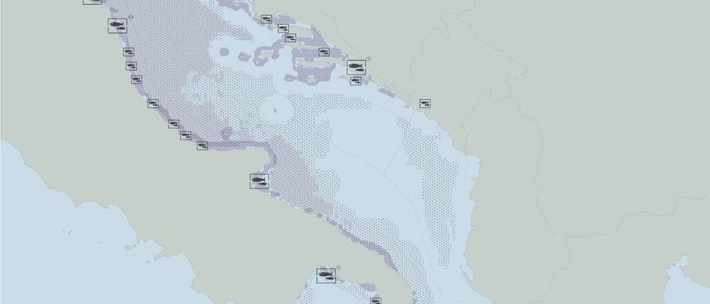
6 Mapping Sea Uses
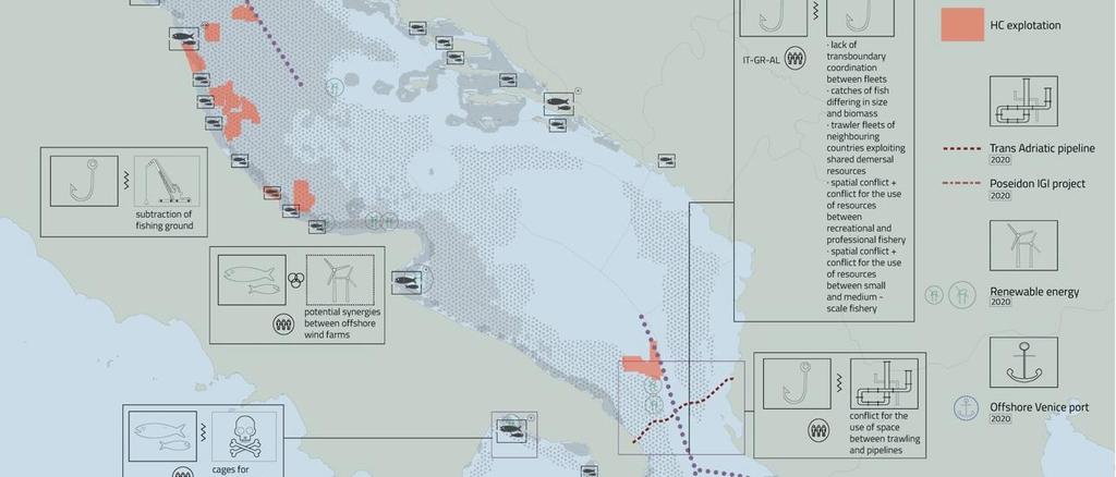
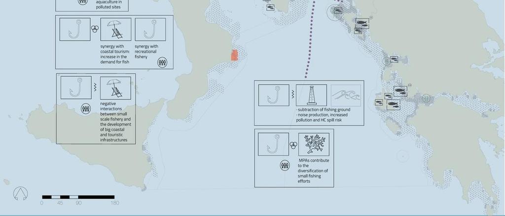
7 Analysis of Space Coexistence between Uses - Differences are visible between coastal and marine areas (especially high waters); - Transboudary areas with potential conflicts in terms of space NA, Puglia Region- Albania- Greece - Results obtained are strictly dependent to data collected - Trawling is the use that in percentage contributes more to the final score
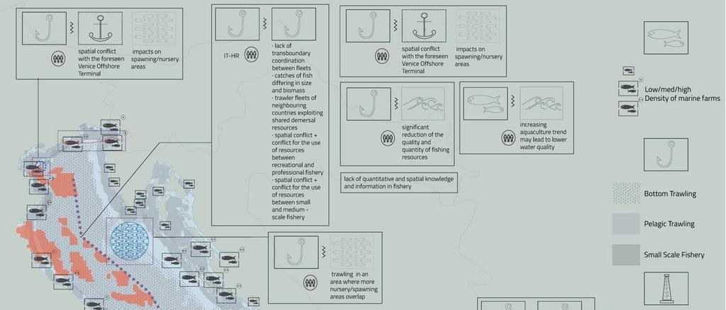

8 Fishery & Aquaculture From analysis to interpretation INTERPRETATION ANALYSIS
 Work in progress -")


9 CUMULATIVE IMPACTS (Halpern et al., 2007) Work in progress - Impacts depend on the presence of Environmental Components which are sensitive to Maritime Uses - The geometry of the results depends on the input data of the analysis (maritime uses, environmental components)


 295 answers 54")

10 CUMULATIVE IMPACTS Matrix of sensitivity Sensitivity analysis through Expert opinion 28 Environmental components 16 Maritime Uses 18 Pressures (from MSFD) 295 answers 54 sensitivities 128 sensitivities 38 sensitivities 12 sensitivities
")


11 CUMULATIVE IMPACTS Matrix of sensitivity (CONFIDENCE) Sensitivity analysis through Expert opinion 28 Environmental components 16 Maritime Uses 18 Pressures (from MSFD) 295 answers 40 sensitivities 106 sensitivities 86 sensitivities


12 Analysis of Space Coexistence between Uses - Differences are visible between coastal and marine areas (especially high waters); - Transboudary areas with potential conflicts in terms of space NA, Puglia Region- Albania- Greece - Results obtained are strictly dependent to data collected - Trawling is the use that in percentage contributes more to the final score
13 PLANNING In ADRIPLAN, the planning proposal has been divided in two parts: - a Strategic Plan for the Adriatic-Ionian Macroregion - Transboundary sea areas with multiple maritime uses in sensitive marine environments - National sea areas with multiple maritime uses in sensitive marine environments - Transboundary sea areas with great importance for the delivery of ecosystem services - a Portfolio of Actions for the Focus Areas
14 Stakeholders involvement Stakeholders contribution Data & information Identification of conflicts and synergies MSP objectives and needs Visioning Identification of pivotal themes for the Focus Areas Inputs for Planning Options aimed at optimizing the rational use of coastal and marine spaces Typology Large Enterprise, Small Medium Enterprise, Public Administration, Economic Interest Association, Civil Society Organizations, Research/Universities, Military, Marine Protected Areas, Projects Geographical relevance International, national, regional and local ADRIPLAN scope the Northern Adriatic (focus area 1) the Southern Adriatic and Northern Ionian (focus area 2) the whole Macro-region

15
 Elements of the ISS: Transposition Plan Member States Expert Group on")
16 DIRECTIVE 2014/89/CE Minimum requirements: Competent authority MSP Plans within 2021 Take into account land-sea interaction (coordination between MSP and ICM) Trans-boundary cooperation between MS Public participation, cooperation between national authorities and stakeholders IMPLEMENTATION SUPPORT STRATEGY (DG MARE, 2015) Elements of the ISS: Transposition Plan Member States Expert Group on MSP High Level Focal Point on IMP Assistance mechanism (call for tender) Studies Cross-sectoral cooperation Cross-border cooperation Data management Joint Action: Building an Efficient Interdisciplinary Scientific Community for Policy Relevant Knowledge on MSP PILOT STUDIES - ADRIPLAN

17 KNOWLEDGE-BASED PLANNING & ADAPTIVE MANAGEMENT MSP needs a continuous science-to-policy dialogue and promotes scientific networking and clustering. Only the use of best available knowledge is able to address an adaptive ecosystem-based management. BLUEMED Vision & SRIA available at: goo.gl/zbjtwh Two projects starting the 1 Jan 2017 Ref. EASME/EMFF/2015/ SIMWESTMED West Mediterranean SUPREME - East Mediterranean EU MS s Authorities in charge of MSP are involved
 More than 200 spatial layers and around 70")


18 ADRIPLAN DATA PORTAL ( data.adriplan.eu) More than 200 spatial layers and around 70 aggregated maps, directly in the portal or accessible as web services (e.g. SHAPE), focusing on maritime uses and environmental components related to the Adriatic-Ionian Region. More modules under development / integration

19 More information at: ADRiatic Ionian maritime spatial PLANning
ADRIPLAN: a Pilot Project on MSP implementation in the AdriaticIonian Region
 The Eleventh International Training Workshop Integrated Maritime Strategy and Marine Spatial Planning in the Mediterranean & the Black Sea Dalyan, Turkey 20 Sept 2016 ADRIPLAN: a Pilot Project on MSP implementation
ADRIPLAN Project Prof. Francesco Musco, IUAV University of Venice
 ADRIPLAN Project Prof. Francesco Musco, IUAV University of Venice msp@iuav.it Riga, Baltic MSP Forum, 17/18 June 2014 Outline The ADRIPLAN Project (DG MARE) Methodological insights Planning Design & interaction
FROM DATA TO WISDOM: INFORMING MSP AND EUSAIR IMPLEMENTATION IN THE ADRIATIC IONIAN REGION
 FROM DATA TO WISDOM: INFORMING MSP AND EUSAIR IMPLEMENTATION IN THE ADRIATIC IONIAN REGION Alessandro Sarretta, Chiara Venier, Andrea Barbanti, Stefano Menegon, Daniel Depellegrin (CNR-ISMAR) alessandro.sarretta@ismar.cnr.it
Mediteranean sea issues in the view of ESPON ESaTDOR project and Marine Spatial Planning in Slovenia
 DIREKTORAT ZA PROSTOR, GRADITEV IN STANOVANJA Mediteranean sea issues in the view of ESPON ESaTDOR project and Marine Spatial Planning in Slovenia BlueMed meeting of stakeholders on a micro-regional level
Aquaculture Spatial Planning: The case of Greece
 Aquaculture Spatial Planning: The case of Greece Nikos Anagnopoulos Panhellenic Association for Small-Medium sized Aquaculture Enterprises Panhellenic Association for Small-Medium sized Aquaculture Enterprises
MR. George ALEXAKIS, parallel session 3. "Mediterranean Sea Region. laying the conditions. for sustainable growth and jobs"
 parallel session 3 "Mediterranean Sea Region laying the conditions for sustainable growth and jobs" MR. George ALEXAKIS, elected Regional Councillor of Crete, Greece and representative of Crete in CRPM.
EUSAIR on sea topics from Slovenian perspective
 MINISTRY OF FOREIGN AFFAIRS REPUBLIC OF SLOVENIA EUSAIR on sea topics from Slovenian perspective Mag. Andreja Jerina National Coordinator 4 EU MRS: 270 millions of population 19 MS 12 non MS Sea basin
Towards coherent maritime spatial planning in the Baltic Sea Region, transnational and project perspective Talis Linkaits Head of VASAB Secretariat
 3 June 2013 Riga PartiSEApate Workshop MSP as Tool for Underwater Cultural Heritage Management in the Baltic Sea Towards coherent maritime spatial planning in the Baltic Sea Region, transnational and project
Croatian physical planning system and strategic approach to MSP
 W 1/7 Past two years all over the Europe: case studies 2 Croatian physical planning system and strategic approach to MSP Vesna Marohnić Kuzmanović Head of Department Croatian Institute for Spatial Development
CONCEPTUAL FRAMEWORK FOR MARINE SPATIAL PLANNING IN THE MEDITERRANEAN
 CONCEPTUAL FRAMEWORK FOR MARINE SPATIAL PLANNING IN THE MEDITERRANEAN CONCEPTUAL FRAMEWORK FOR SPATIAL PLANNING IN THE MEDITERRANEAN LEGAL NOTICE The designations employed and the presentation of the material
MODELS AND TOOLS FOR GOVERNANCE OF
 Working Papers Collection No. 1/2015 MODELS AND TOOLS FOR GOVERNANCE OF THE ADRIATIC AND IONIAN SEAS www.unimc.it/maremap NATIONAL POLITICS AND EU POLITICS: THE MARITIME SPATIAL PLANNING AND INTEGRATED
Maritime Spatial Planning in the Baltic Sea Region
 Maritime Spatial Planning in the Baltic Sea Region Talis Linkaits Head of VASAB Secretariat 20 May 2015 Helsinki A cooperation of ministers of the 11 Baltic Sea Region countries responsible for spatial
SPLAN-Natura Towards an integrated spatial planning approach for Natura th January, 2017 Brussels. Commissioned by DG Environment
 SPLAN-Natura 2000 Towards an integrated spatial planning approach for Natura 2000 Commissioned by DG Environment 17 th January, 2017 Brussels V. Simeonova (Ph.D.) Drivers towards integrating Biodiversity
Maritime Spatial Planning in the Baltic Sea Region
 Maritime Spatial Planning in the Baltic Sea Region Past, present, perspective Talis Linkaits VASAB Secretariat XIX International Environmental Forum 22 March 2018, Saint Petersburg A cooperation of ministers
Blue Growth: The Adriatic and Ionian Region
 Blue Growth: The Adriatic and Ionian Region Maritime Clusters: types of support and areas for cooperation AQUAE VENICE 2015 EXPO Matteo Bocci, Ecorys Venice, 28 th September 2015 Structure of this intervention
1. Baltic SCOPE Towards coherence and cross-border solutions in Baltic Maritime Spatial Plans
 NSHC 32th Conference Explanatory Note Dublin, Ireland Item E.2 MSP 21-23 June 2016 Germany Cross border MSP for the EEZ, a case study from the Baltic Sea The Federal Maritime and Hydrographic Agency of
National Perspectives - Portugal. Margarida Almodovar
 National Perspectives - Portugal Margarida Almodovar margarida.almodovar@mam.gov.pt from base line to the external limit of the continental shelf behind 200 miles and according to UNCLOS definitions Economic
Integrated Strategies in regional development
 Inspire policy making by territorial evidence ESPON Seminar Territories Acting for Economic Growth: Using territorial evidence to meet challenges towards 2020 Integrated Strategies in regional development
Marine/Maritime Spatial Planning Andrej Abramić
 Marine/Maritime Spatial Planning Andrej Abramić EcoAqua SUMMER SCHOOL: Ecosystem approach to aquaculture 26-29th of October 2015 Research and Technology to enhance excellence in Aquaculture development
SIMCelt Supporting Implementation of Maritime Spatial Planning in the Celtic Seas. Patrice Laporte
 SIMCelt Supporting Implementation of Maritime Spatial Planning in the Celtic Seas Patrice Laporte patrice.laporte@shom.fr General background In July 2014 the EU adopted a directive establishing a framework
Emerging tensions between blue growth and good environmental status
 Emerging tensions between blue growth and good environmental status Dr Peter Jones, Reader in Environmental Governance, Dept of Geography, University College London www.bnycharters.com Slides @PJSJones
Maritime Spatial Planning: Transboundary Cooperation in the Celtic Seas Looking Ahead
 Maritime Spatial Planning: Transboundary Cooperation in the Celtic Seas Looking Ahead Looking ahead MSP in the context of the European Maritime and Fisheries Fund (EMFF) and beyond SIMCelt Final Conference
Introduction to IMP: need and added value
 Introduction to IMP: need and added value Christophe Le Visage Consultant Stratégies Mer et Littoral 1 Summary IMP : Why? The case for integration 1 What is IMP? 2 Content, process IMP: Added Value 3 2
Mediterranean Sea and Territorial Development, Opportunities and Risks
 EESC Hearing Towards an EU Macro-Regional Strategy for the Mediterranean Mediterranean Sea and Territorial Development, Opportunities and Risks Michaela Gensheimer Structure of Intervention Part I: What
Identification of maritime spatial planning best practices in the Baltic Sea Region and other EU maritime regions
 Identification of maritime spatial planning best practices in the Baltic Sea Region and other EU maritime regions PLAN BOTHNIA Baltic Sea Region Stakeholder Meeting Jacek Zaucha, Magdalena Matczak Two
MSP in the Adriatic: problem and opportunity analysis, thematic mapping and inputs for a future
 MSP in the Adriatic: problem and opportunity analysis, thematic mapping and inputs for a future vision Action 4.3 Final Report 10 February 2014 External Expert: Thetis S.p.A. Committente: Regione Veneto
Natura 2000 and spatial planning. Executive summary
 Natura 2000 and spatial planning Executive summary DISCLAIMER The information and views set out in this study are those of the author(s) and do not necessarily reflect the official opinion of the Commission.
PLAN BOTHNIA MARE/2009/16
 PLAN BOTHNIA MARE/2009/16 Hermanni Backer Project Manager HELCOM Secretariat Partner Kick-Off Meeting Nordregio, Stockholm December 16 2010 Photo: Elena Bulycheva PLAN BOTHNIA MARE/2009/16 Co-financed
ICZM and MSP in the Black Sea Region
 ICZM and MSP in the Black Sea Region Drd. Claudia Coman, Environmental engineer AG ICZM Focal Point, Romania Black Sea Commission Black Sea Commission on the Protection of the Black Sea against Pollution
Country Fiche Lithuania
 Country Fiche Lithuania Updated June 2018 1. General information The Lithuanian maritime space is delimited by the Decree of the Government of the Republic of Lithuania of 6 December, 2004, No. 1597 and
Marine Spatial Planning in the Baltic Sea Region
 Marine Spatial Planning in the Baltic Sea Region Towards coherence and cross-border solutions in Baltic Maritime Spatial Plans Coordinator & Project manager Dr Ingela Isaksson Swedish Agency for Marine
BURGAS CASE STUDY: LAND-SEA INTERACTIONS. Dr. Margarita Stancheva
 BURGAS CASE STUDY: LAND-SEA INTERACTIONS Dr. Margarita Stancheva Name of presentation NEED FOR COHERENCE BETWEEN LAND AND SEA ACTIVITIES Name presenter Burgas is the fourth largest city in Bulgaria and
2012 FORUM OF MARINE PROTECTED AREAS IN THE MEDITERRANEAN ANTALYA, TURKEY
 2012 FORUM OF MARINE PROTECTED AREAS IN THE MEDITERRANEAN ANTALYA, TURKEY SPECIAL EVENT Challenges for Open Seas MPAs in the Mediterranean region November 27, 2012. 15h00-16H00 Slide # 1 2012 FORUM OF
This document has been verified by the responsible MSP authority (or representative) of Slovenia on
 of Slovenia on") Contacts MSP National Level Lenča Humerca Šolar Ministry of the Environment and Spatial Planning Dunajska 48, SI - 1001 Ljubljana, Slovenia E-mail: lenca.humerca-solar@gov.si Phone: + 386 1 478 7400 Website:
Contacts MSP National Level Lenča Humerca Šolar Ministry of the Environment and Spatial Planning Dunajska 48, SI - 1001 Ljubljana, Slovenia E-mail: lenca.humerca-solar@gov.si Phone: + 386 1 478 7400 Website:
Country Fiche Estonia
 Country Fiche Estonia Updated October 2017 1. General information Size of internal waters (to the baseline) and territorial sea (12-nm zone from the baseline) approximately 25 200 km 2. Exclusive economic
The Process of Spatial Data Harmonization in Italy. Geom. Paola Ronzino
 The Process of Spatial Data Harmonization in Italy Geom. Paola Ronzino ISSUES Geospatial Information in Europe: lack of data harmonization the lack of data duplication of data CHALLENGES Challenge of INSPIRE:
Recommendation on how to perform analysis of land-sea interactions, combining MSP and ICZM in the considered project area
 Recommendation on how to perform analysis of land-sea interactions, combining MSP and ICZM in the considered project area Initial definitions Deliverable No 1.3.7 Co-funded by the European Maritime and
Country Fiche Latvia Updated October 2016
 Country Fiche Latvia Updated October 2016 1. General information Marine area under Latvian jurisdiction includes inland sea waters, Territorial sea (12 nautical miles from the baseline) and exclusive economic
Open source tools to support Integrated Coastal Management and Maritime Spatial Planning
 Open source tools to support Integrated Coastal Management and Maritime Spatial Planning Stefano Menegon 1, Alessandro Sarretta 1, Andrea Barbanti 1, Elena Gissi 2, and Chiara Venier 1 1 Consiglio Nazionale
Launch of the ESPON 2013 Programme. European observation network on territorial development and cohesion
 Launch of the ESPON 2013 Programme European observation network on territorial development and cohesion Framework conditions for the ESPON 2013 Programme Policy development in use of territorial evidence
Outline National legislative & policy context Regional history with ESSIM ESSIM Evaluation Phase Government Integration via RCCOM Regional ICOM Framew
 What MSP Implementation could change in the Maritimes Region Tim Hall, Regional Manager Oceans and Coastal Management Division Ecosystem Management Branch Fisheries and Oceans Canada Maritimes Region BIO
Slovenia. Maritime Spatial Planning Country Information. Slovenia.
 Slovenia Maritime Spatial Planning Country Information Slovenia The European MSP Platform is financed by the EU Commission under the EMFF Workprogrammes 2014 and 2015. The European MSP Platform is a result
Country Fiche Sweden Updated May 2018
 Country Fiche Sweden Updated May 2018 1. General information 2 the territorial sea (12-nm zone) 70,000 km2 the Exclusive Economic Zone 60,000 km2 the EEZ is limited to the central line between adjacent
Maritime Spatial Planning in a CCB s context Mikhail Durkin MSP Seminar, 22 November 2016 Riga, Latvia
 Maritime Spatial Planning in a CCB s context Mikhail Durkin MSP Seminar, 22 November 2016 Riga, Latvia co-funded by EU LIFE Programme Maritime Spatial Planning "a public process of analyzing and allocating
Evaluation of Spatial Planning as a Tool for Integrated Marine Management Status, Obstacles and Research Gaps
 Evaluation of Spatial Planning as a Tool for Integrated Marine Management Status, Obstacles and Research Gaps Baltic MSP Forum Riga 17.-18. June 2014 A. Morf & A. Grimvall: Swedish Institute for the Marine
Country Fiche Estonia
 Country Fiche Estonia Deleted: October Updated May 2018 Deleted: 7 1. General information Size of internal waters (to the baseline) and territorial sea (12-nm zone from the baseline) approximately 25 200
BURGAS CASE STUDY: LAND-SEA INTERACTIONS
 BURGAS CASE STUDY: LAND-SEA INTERACTIONS Dr. Margarita Stancheva IO-BAS, Bulgaria Name of presentation CROSS BORDER MARITIME SPATIAL PLANNING IN THE BLACK SEA ROMANIA AND BULGARIA (MARSPLAN BS) Project
2010/2011: Proposals for a CPMR Maritime Agenda
 2010/2011: Proposals for a CPMR Maritime Agenda Political Bureau Tromsø 11 June 2010 CPMR MARITIME AGENDA: THE MAIN ISSUES Maritime, coastal territories and sustainable development: how to make approaches
MARINE PLANNING IN THE NETHERLANDS
 MARINE PLANNING IN THE NETHERLANDS Hermien Busschbach Ministry of Transport, Public Works and Water Management (DG Water) Bremen, 2 May 2007 Marine Planning in the Netherlands OUTLINE policy context; international
Natura 2000 in the marine environment: state of implementation and next steps
 Life on the blue planet: biodiversity research and the new European marine policies EPBRS European Platform on Biodiversity Research Strategy Porto, Portugal 7-9 November 2007 Natura 2000 in the marine
Marine Spatial Planning (MSP): A practical approach to ecosystembased
: A practical approach to ecosystembased") Marine Spatial Planning (MSP): A practical approach to ecosystembased management Erik Olsen, Institute of Marine Research, Norway Fanny Douvere, International Oceanographic Commission Overview Why we need
Marine Spatial Planning (MSP): A practical approach to ecosystembased management Erik Olsen, Institute of Marine Research, Norway Fanny Douvere, International Oceanographic Commission Overview Why we need
Findings and recommendations from Central Baltic case
 W 1/1 Recommendations on transboundary planning from Baltic SCOPE Findings and recommendations from Central Baltic case Ingūna Urtāne Director of Spatial Planning Department of the Ministry of Environmental
geoporrtal of Tools & Data for sustainable Management of coastal and marine Environment (ADRION205)
") PORTODIMARE geoporrtal of Tools & Data for sustainable Management of coastal and marine Environment (ADRION205) Minutes of the PORTODIMARE International Conference on ICZM&MSP 11/2018 Page 1 PORTODIMARE
PORTODIMARE geoporrtal of Tools & Data for sustainable Management of coastal and marine Environment (ADRION205) Minutes of the PORTODIMARE International Conference on ICZM&MSP 11/2018 Page 1 PORTODIMARE
PLAN BOTHNIA MSP 1/2011 PLAN BOTHNIA. PLAN BOTHNIA short description (document 3/1) PLAN BOTHNIA MSP 1 Pori, Finland, March
 PLAN BOTHNIA MSP 1 Pori, Finland, March") PLAN BOTHNIA Co-Financed Under European Integrated maritime Policy PLAN BOTHNIA short description (document 3/1) PLAN BOTHNIA MSP 1 Pori, Finland, March 7-8 2011 PLAN BOTHNIA MSP 1/2011 Agenda Item 3 Introduction
PLAN BOTHNIA Co-Financed Under European Integrated maritime Policy PLAN BOTHNIA short description (document 3/1) PLAN BOTHNIA MSP 1 Pori, Finland, March 7-8 2011 PLAN BOTHNIA MSP 1/2011 Agenda Item 3 Introduction
The Baltic Sea Region Maritime Spatial Planning Data Expert Sub-group. First Report 2015/2016/
 The Baltic Sea Region Maritime Spatial Planning Data Expert Sub-group First Report 2015/2016/2017 21.04.2017. Contents 1. Glossary 2 2. Introduction. 3 3. MSP Data. 5 3.1. Input Data. 5 3.2 Output Data.
Implementation of the Political Declaration on energy cooperation between the North Seas Countries. Support Group 1 on Maritime Spatial Planning
 Implementation of the Political Declaration on energy cooperation between the North Seas Countries Support Group 1 on Maritime Spatial Planning Work Programme 1. Work area as outlined in Annex I to the
Contents: LEVANTE DE ALMERÍA A INFORMATION SYSTEM OBJECTIVES AND ACTIONS GEOGRAPHIC INFORMATION SYSTEM RESULTS
 Contents: LEGAL FRAMEWORK: BARCELONA CONVENTION AND ICZM PROTOCOL; COASTAL AREAS MANAGEMENT PROGRAMME; CAMP LEVANTE DE ALMERIA; OVERALL AIM AND KEY IDEAS AREA PHASES PROJECT STRUCTURE ACTIVITIES INSTITUTIONAL
The Danish Maritime Spatial Data Infrastructure (MSDI) Geodata of the Sea
 Geodata of the Sea") MSDI/MSP The Danish Maritime Spatial Data Infrastructure (MSDI) Geodata of the Sea Components of an infrastructure: DATA - metadata, datasets FUNCTIONALITY - spatial data services, web services and other
MSDI/MSP The Danish Maritime Spatial Data Infrastructure (MSDI) Geodata of the Sea Components of an infrastructure: DATA - metadata, datasets FUNCTIONALITY - spatial data services, web services and other
Maritime Spatial Planning
 Maritime Spatial Planning The Dutch experience Kopenhagen 28 november 2012 Lodewijk.Abspoel@minienm.nl North Sea 2 Outline History of MSP in the Netherlands Spatial Plan for the Dutch EEZ, principles and
Country reports. Israel did not establish an Exclusive Economic Zone. Consequently, its jurisdiction is restricted to the Israeli territorial waters.
 Country reports I. ISRAEL Disclaimer This document has not been adopted by the European Commission and should therefore not be relied upon as a statement of the European Commission. The purpose of this
Country Fiche Sweden.
 Country Fiche Sweden 1. General information the territorial sea (12- nm zone) 70,000 km2 the Exclusive Economic Zone 60,000 km2 the EEZ is limited to the central line between adjacent states because the
Biodiversity and Protected Areas Management Project
 Biodiversity and Protected Areas Management Project Technical Advisor ESA region: Selwyn Willoughby Coordinator ESA region: Christine Mentzel FlexiCadastre EMEA Regional User Conference, Cape Town, South
HELCOM-VASAB Maritime Spatial Planning Working Group Twelfth Meeting Gdansk, Poland, February 2016
 HELCOM-VASAB Maritime Spatial Planning Working Group Twelfth Meeting Gdansk, Poland, 24-25 February 2016 Document title MSP exhibition stands at the European Maritime Day 2016 Code 7-3-Add.1 Category INF
Strategic Environmental Assessment / Environmental Impact Assessment
 Contacts MSP National Level Zrinka Sindler Ministry of Construction and Physical Planning Head of Department Ph.: +385 1 3712747 E-mail: zrinka.sindler@mgipu.hr Sandra Momcilovic Ministry of Construction
ESPON 2020 Cooperation Programme. Anneloes van Noordt MC-member Belgium
 ESPON 2020 Cooperation Programme Anneloes van Noordt MC-member Belgium Anneloes.vannoordt@vlaanderen.be Outline ESPON 2020 Cooperation Programme Applied Research Targeted Analysis Database & Tools Outreach
Non-Governmental Organizations for Spatial Data Infrastructure. Environmental Democracy Case
 Non-Governmental Organizations for Spatial Data Infrastructure Environmental Democracy Case L.Jovičić, S.Vrečar, V.Cetl, K.Ristovski GSDI Small Grant Program Award 2011-2012 Non-Governmental Organisations
The National Spatial Strategy
 Purpose of this Consultation Paper This paper seeks the views of a wide range of bodies, interests and members of the public on the issues which the National Spatial Strategy should address. These views
Country Fiche Latvia.
 Country Fiche Latvia 1. General information Marine waters under Latvian jurisdiction include inland sea waters, territorial sea (12 nautical miles from the baseline) and exclusive economic zone (EEZ) waters.
Maritime Spatial Planning Conference Addressing Land-Sea Interactions
 DIRECTORATE-GENERAL FOR MARITIME AFFAIRS AND FISHERIES Maritime Spatial Planning Conference Addressing Land-Sea Interactions St.Julian s, Malta 15-16 June 2017 #MSPLandSea Conference Report Maritime Spatial
EA SEA-WAY Project. 7 th Coordination Meeting. WP5 Development of sustainable passenger transport models for the Adriatic basin and capacity building
 EA SEA-WAY Project 7 th Coordination Meeting WP5 Development of sustainable passenger transport models for the Adriatic basin and capacity building 3 rd Cross Border Board Ravenna, January 26, 2016 The
TOWARDS STRATEGIC SPATIAL PLANNING IN JAMAICA: THE NATIONAL SPATIAL PLAN
 TOWARDS STRATEGIC SPATIAL PLANNING IN JAMAICA: THE NATIONAL SPATIAL PLAN JIEP 5th Biennial Conference on the Environment: Balancing National Development and Environmental Protection June 6, 2011 Jamaica
Experiences of public-private partnerships in the Euromediterranean relations and in the Po Valley, promoting a more balanced European territory
 Experiences of public-private partnerships in the Euromediterranean relations and in the Po Valley, promoting a more balanced European territory Claudio Tolomelli PolyMetrexPlus project s objectives To
PartiSEApate Conference
 Baltic Maritime Spatial Planning Forum PartiSEApate Conference C r e a t i n g c o m m o n u n d e r s t a n d i n g B a l t i c M a r i t i m e S p a t i a l P l a n n i n g F o r u m B a l t i c M a
Baltic Sea Region cooperation in Maritime Spatial Planning - HELCOM/VASAB
 Baltic Sea Region cooperation in Maritime Spatial Planning - HELCOM/VASAB Sten Jerdenius Swedish Ministry of the Environment HELCOM/VASAB MSP Group Baltic Sea Region subregional workshop Espoo 31 March
BOSNIA AND HERZEGOVINA
 Studies to support the development of sea basin cooperation in the Mediterranean, Adriatic and Ionian, and Black Sea CONTRACT NUMBER MARE/2012/07 - REF. NO 2 REPORT 1 - ANNEX 2.2 COUNTRY FICHE - ANNEX
Coastal Mapping Follow on? Bruno Frachon Corine Lochet Gaël Morvan
 Coastal Mapping Follow on? Bruno Frachon Corine Lochet Gaël Morvan Shared objectives; IHO DG MARE CPMR Development of a Joint European Coastal Mapping Programme (JECMaP) within the IHO EU network with
Marine Spatial Planning Experience from Mecklenburg-Vorpommern (Germany) By Susan Toben
 By Susan Toben") Marine Spatial Planning Experience from Mecklenburg-Vorpommern (Germany) By Susan Toben Ministry of Transport, Building and Regional Development Mecklenburg Vorpommern PlanCoast Lead Partner Administrative
Marine Spatial Planning Experience from Mecklenburg-Vorpommern (Germany) By Susan Toben Ministry of Transport, Building and Regional Development Mecklenburg Vorpommern PlanCoast Lead Partner Administrative
Marine Spatial Planning: A Tool for Implementing Ecosystem-Based Management
 Marine Spatial Planning: A Tool for Implementing Ecosystem-Based Management Steven Murawski, Ph.D., Ecosystem Goal Team Lead National Oceanic and Atmospheric Administration NOAA November 16, 2009 1 To
EU HOs in Mediterranean and Black Sea (MBS) CROATIA FRANCE GREECE ITALY MALTA X SLOVENIA X SPAIN ROMANIA X
 CROATIA FRANCE GREECE ITALY MALTA X SLOVENIA X SPAIN ROMANIA X") EU HOs in Mediterranean and Black Sea (MBS) CROATIA FRANCE GREECE ITALY MALTA X SLOVENIA X SPAIN ROMANIA X Croatia Current status of hydrographic survey in acc. IHO C-55 pub. criteria Croatia Croatia by
EU HOs in Mediterranean and Black Sea (MBS) CROATIA FRANCE GREECE ITALY MALTA X SLOVENIA X SPAIN ROMANIA X Croatia Current status of hydrographic survey in acc. IHO C-55 pub. criteria Croatia Croatia by
Stepping into the sea - New evidence on territorial development and the opportunities and risks for European seas and maritime regions
 ESPON 2013 Programme Workshop Stepping into the sea - New evidence on territorial development and the opportunities and risks for European seas and maritime regions 15 May 2013 9h00 16h30 Venue The Norwegian
Tackling MSP integration challenges in the BSR
 Towards sustainable governance of Baltic marine space 2015 2018 BALTSPACE Towards sustainable governance of Baltic marine space Tackling MSP integration challenges in the BSR Michael Gilek, Södertörn University,
Management Planning & Implementation of Communication Measures for Terrestrial Natura 2000 Sites in the Maltese Islands Epsilon-Adi Consortium
 Management Planning & Implementation of Communication Measures for Terrestrial Natura 2000 Sites in the Maltese Islands Epsilon-Adi Consortium Briefing Meetings, February 2013 CT3101/2011, MEPA, Malta
POLISH LAW ON MSP. Andrzej Cieślak Maritime Office in Gdynia
 POLISH LAW ON MSP Andrzej Cieślak Maritime Office in Gdynia Preconditions Ownership/management of allsea areas (internal sea waters, territorial sea, EEZ): the State, and in its name the Minister responsible
MARINE SPATIAL PLANNING & MARINE CADASTRE: CHALLENGES AND ISSUES
 MARINE SPATIAL PLANNING & MARINE CADASTRE: CHALLENGES AND ISSUES Roger Longhorn Secretary General, GSDI Association rlonghorn@gsdi.org Member, IHO Marine SDI Working Group ral@alum.mit.edu Member, UNESCO
Cross-border Maritime Spatial Plan for the Black sea - Romania and Bulgaria project
 Cross-border Maritime Spatial Plan for the Black sea - Romania and Bulgaria project in Romania and Bulgaria Plan Presentation A first step in the management of the marine areas of Romania and Bulgaria
From the Venice Lagoon Atlas towards a collaborative federated system
 From the Venice Lagoon Atlas towards a collaborative federated system City of Venice Alessandro Mulazzani CORILA Consortium for Coordination of Research Activities Concerning the Venice Lagoon System ISMAR-CNR
Third Cohesion report February 2004
 February 2004 A new partnership for cohesion Convergence, Competitiveness and Co-operation METREX meeting S. Sebastian, Luisa Sanches DG REGIO The 3rd CR structure 1. Analysis of situation and trends in
Marine Spatial Planning as an important tool for implementing the MSFD
 Marine Spatial Planning as an important tool for implementing the MSFD Risto Kalliola Tallinn, Nov. 16 th 2012 DEPARTMENT OF GEOGRAPHY AND GEOLOGY University of Turku, Finland Ten principles to provide
Maritime Spatial Planning Framework Directive Supported by INSPIRE
 Maritime Spatial Planning Framework Directive Supported by INSPIRE Andrej Abramić, Vanda Nunes de Lima, Paul Smits, Emanuele Bigagli, Chris Schubert European Commission Joint Research Centre Institute
Margarita Stancheva Hristo Stanchev & Robert Young 2. MEDCOAST JUBILEE WORKSHOP May 2015, Iberotel Sarigerme Park, Dalaman, Turkey
 Margarita Stancheva Hristo Stanchev & Robert Young 2 INTRODUCTION: Bulgarian Black Sea coast INTRODUCTION: Increasing pressure on Bulgarian coastal zone In 2011, of the 7 364 570 people that lived in Bulgaria,
EXPERT ANALYSIS ON GEOGRAPHICAL SPECIFICITIES
 EXPERT ANALYSIS ON GEOGRAPHICAL SPECIFICITIES Mountains, Islands and Sparsely Populated Areas Dr. Gilda Carbone 9 Oct 2018 Objectives: to gather basic information from relevant programming documents (PAs,
r i l:!n::5 ] F i n a l Repo rt Coas ta l Zon e Managemen t ( I CZM )
![r i l:!n::5 ] F i n a l Repo rt Coas ta l Zon e Managemen t ( I CZM )](/thumbs/94/122218329.jpg "r i l:!n::5 ] F i n a l Repo rt Coas ta l Zon e Managemen t ( I CZM )") C l i e n t : Eu ropean Com m iss ion - DG Env i ron men t S u bj e ct : An a lys is of Mem be r Sta tes p rog ress repo rts on I n teg rated Coas ta l Zon e Managemen t ( I CZM ) D o c. t i t l e : F
C l i e n t : Eu ropean Com m iss ion - DG Env i ron men t S u bj e ct : An a lys is of Mem be r Sta tes p rog ress repo rts on I n teg rated Coas ta l Zon e Managemen t ( I CZM ) D o c. t i t l e : F
Additional information (material for interactions and analysis chapter) to document 3/1, the PLAN BOTHNIA MSP Assessment
 to document 3/1, the PLAN BOTHNIA MSP Assessment") Co-Financed Under European Integrated Maritime Policy PLAN BOTHNIA MSP 2/2011 MSP Assessment Add 1 PLAN BOTHNIA MSP 2 Uppsala, Sweden June 14-15 2011 Agenda Item 3 PLAN BOTHNIA MSP Assessment Document
Co-Financed Under European Integrated Maritime Policy PLAN BOTHNIA MSP 2/2011 MSP Assessment Add 1 PLAN BOTHNIA MSP 2 Uppsala, Sweden June 14-15 2011 Agenda Item 3 PLAN BOTHNIA MSP Assessment Document
Implementation of the ESPON 2020 cooperation program. 16 January 2017 Anneloes van Noordt
 Implementation of the ESPON 2020 cooperation program 16 January 2017 Anneloes van Noordt Outline! ESPON Cooperation Program! Specific Objectives! Applied Research! Targeted Analysis! Database & Tools!
Integrated Maritime Policy
 Integrated Maritime Policy The study was written by Progress Consulting S.r.l. and Living Prospects Ltd. It does not represent the official views of the Committee of the Regions. More information on the
How to integrate maritime cultural heritage into maritime spatial planning?
 2ND SUBMARINER Conference #BetterOff Blue17 Creating synergies for a biobased society How to integrate maritime cultural heritage into maritime spatial planning? Susanne Altvater, s.pro 28.09.2017 #BetterOffBlue17
Possibilities for applying ES assessment results in spatial planning in Latvia
 Possibilities for applying ES assessment results in spatial planning in Latvia Inga Hoņavko LIFE EcosystemServices project manager LIFE Viva Grass seminar, Sigulda, 17.05.2018 Projekts LIFE EcosystemServices,
Agenzia per la coesione Territoriale. Obstacles on maritime borders
 7th MEETING OF THE WORKING GROUP ON INNOVATIVE SOLUTIONS TO CROSSBORDER OBSTACLES Obstacles on maritime borders 3rd May 2018 French Permanent Representation to the EU Place de Louvain 14, Brussels Viviana
Carpathians Unite mechanism of consultation and cooperation for implementation of the Carpathian Convention
 Carpathians Unite mechanism of consultation and cooperation for implementation of the Carpathian Convention Zbigniew Niewiadomski, UNEP/GRID-Warsaw Centre First Joint Meeting of the Carpathian Convention
This document has been verified by the responsible MSP authority (or representative) of Lithuania on
 of Lithuania on") Contact MSP in general Ms. Algimantė Treinienė Head of Spatial Planning Urban Development and Architecture Division Construction and Territorial Planning Department Ministry of Environment A. Jakšto 4
Contact MSP in general Ms. Algimantė Treinienė Head of Spatial Planning Urban Development and Architecture Division Construction and Territorial Planning Department Ministry of Environment A. Jakšto 4