Down East RPO. Strategic Prioritization Office of Transportation Local Input Point Assignment Methodology. Introduction
|
|
|
- Donald Terry
- 6 years ago
- Views:
Transcription
1 Down East RPO Introduction Strategic Prioritization Office of Transportation Local Input Point Assignment Methodology The Down East Rural Planning Organization (DERPO) is required by state law to develop a local input methodology for prioritizing all transportation projects (highway, bike and pedestrian, public transportation, aviation, rail and ferry) within the RPO boundary that may compete for state and federal funding, and to submit the methodology to the North Carolina Department of Transportation (NCDOT) for approval. The DERPO has developed this prioritization method in an effort to satisfy the quantitative, datadriven requirements of the legislation while protecting the discretion of local officials by incorporating subjective, qualitative local input where possible. This process is intended to be open and transparent. As such, all meetings of the Technical Coordinating Committee (TCC) and Transportation Advisory Committee (TAC) are open to the public and public participation will be solicited in accordance with the RPO s previously adopted Public Involvement Policy. In addition, the draft methodology and preliminary point assignments will be posted at the Eastern Carolina Council of Governments DERPO webpage: along with instructions for submitting comments. Comments will be collected by the RPO Coordinator and distributed to the TCC and TAC as part of their normal meeting packets. Schedule During every Strategic Prioritization Office of Transportation (SPOT) cycle the DERPO will create a Prioritization Sub-committee where at least one voting member from each of the five counties and the two NCDOT Highway Divisions will participate. This Sub-committee will make the initial draft local point assignments. At the initial convening of the Sub-committee any changes to Strategic Transportation Improvement legislation or the SPOT formulas, rankings, or process will be reviewed and discussed. Based on that review this methodology will be revisited to make any changes or adjustments necessary to remain in compliance and to optimize our prioritization process to the needs of the DERPO region. Any changes or adjustments will be made available for public comment in accordance with the DERPO Public Involvement Policy and subsequently approved by the TCC and TAC prior to being enacted. When NCDOT opens the window for submission of new candidate projects the Sub-committee will meet to review existing SPOT projects from every transportation mode with the potential to be removed from the system and new candidate projects from every transportation mode with the potential to be submitted to the SPOT scoring system. The recommendations from this Subcommittee will be presented to the TCC and TAC at their next regularly scheduled meeting for approval. This meeting is open to the public.
2 After the Regional Impact and Division Needs scores are released by NCDOT the Sub-committee will meet to generate the Local Input Scores based on the scoring criteria described below and consultation with NCDOT Division staff, neighboring MPOs and RPOs, local aviation, rail, ferry, port, and transit operators. As soon as those preliminary scores are calculated they will be posted on the Eastern Carolina Council of Governments DERPO webpage: for public review and comment for no less than 30 days. Any public comment gathered during this time will be considered when applying Local Discretionary Points. The TCC and TAC will review the final Regional Impact and Division Needs Project Scores provided by the Sub-committee and discuss whether to apply Local Discretionary Points at their meetings, which will be public meetings where public comment will specifically be sought on the final scores and where the public comments, and any others received during the prioritization process, will be a basis for applying any Discretionary points. Local Discretionary Points will be discussed in an open meeting and any points assigned and their justifications will be documented in the meeting minutes. Final adjusted scores will be generated based on final scores and Discretionary points and will be posted, with any appropriate justifications necessary, to the RPO website at that time. Final points will be assigned based on final adjusted scores and points will be entered into SPOT On!ine. For SPOT 3.0 in 2014 the timeline is as follows: Quantitative scores are released for SPOT 3.0 projects by NCDOT (May 14, 2014) Proposed Local input points are allocated to SPOT 3.0 projects (May-June 2014) A 30 day public comment period is provided to review and comment on local input point allocations (June 2014) DERPO TAC endorses final local input point allocations and submits them to NCDOT (July 24, 2014) Final scores are issued to SPOT 3.0 projects and posted on the DERPO website (August 2014) Scoring Criteria The following scoring criteria will be used to generate a raw score for each transportation project, regardless of mode. Each project will receive a preliminary and final score. For the Quantitative Score the DERPO will use quantitative criteria developed by NCDOT and the Eastern NC MPO/RPO Coalition. These criteria provide an adequate quantitative assessment of the transportation projects in the RPO area. The SPOT Score will be equal to 50% of the Total Project Score. This aspect of the score will be calculated using this formula: Quantitative Score = [(SPOT Score/Max SPOT Score) x 100] x 50% For Regional Impact projects the Max SPOT Score = 70 For Division Needs projects the Max SPOT Score = 50 Example Quantitative Regional Score: [(65/70) x 100] x.5 = 46.43
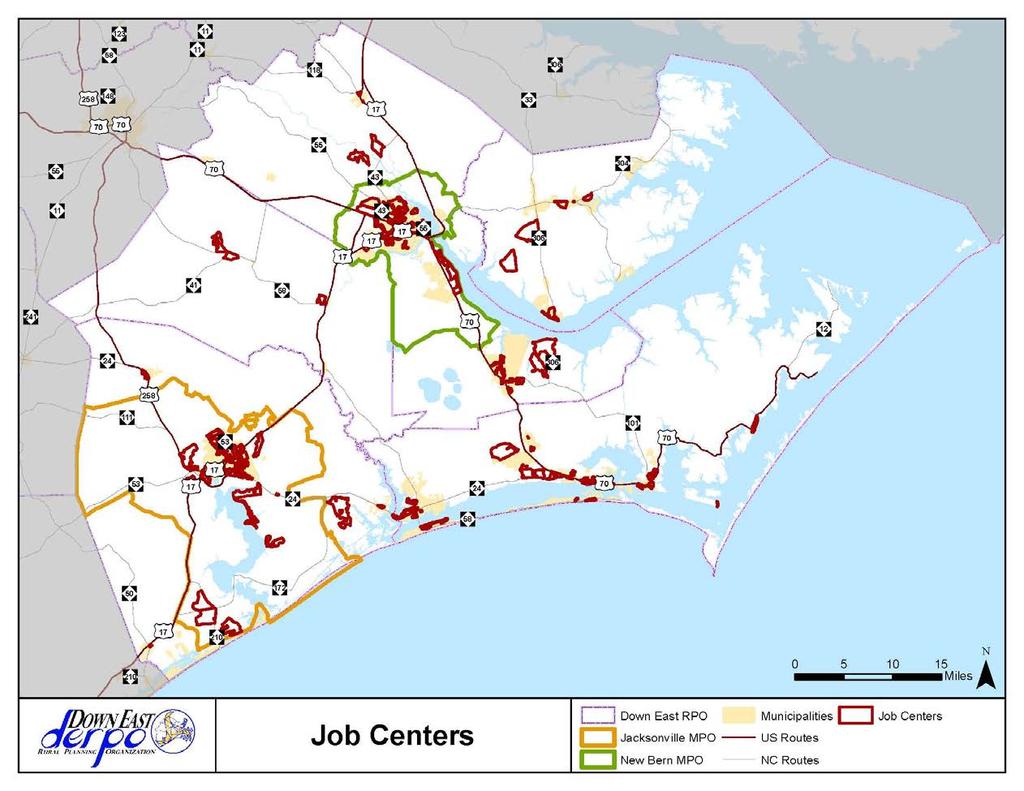
3 For the Qualitative Score the DERPO Sub-committee selected six factors in our geographic area to evaluate local projects on across all modes of transportation. This evaluation will be based on access and connections provided by the project to those six factors that promote and foster our communities in Eastern North Carolina. Those factors are: Agriculture, Education, Health Care, Job Centers, Military and Ports, and Tourism. Each of those factors have been identified in the following ways: Agriculture ESRI s Community Analyst is a web-based mapping program that can search for and identify the location of businesses by NAICS (North American Industry Classification System) code in a defined geographic area. This program extracts business data which is current as of January 2013 from a comprehensive list of businesses licensed from Dun & Bradstreet, a leading source of commercial information and insight on businesses. Community Analyst was used to identify a total of 435 agricultural businesses with 3-digit NAICS codes of 111 (crop production), 112 (animal production and aquaculture), 113 (forestry and logging) and 115 (support activities for agriculture and forestry) in the DERPO area. These results were exported into an Excel spreadsheet where the name, address, 6-digit NAICS code and sales volume of each identified business was listed. The top earning businesses whose combined sales volume equaled approximately 50% of the total sales volume of all 435 businesses in the DERPO area were then identified. These 18 identified businesses were then mapped in ArcGIS, a mapping software program, according to their address, parcel spatial data, aerial imagery, and GoogleMaps. Access points to the transportation network for each mapped business were then identified. Education Community colleges, universities, and their off-campus centers or satellite campuses in the DERPO area were mapped in ArcGIS using spatial data downloaded from NC OneMap (a statewide data and map service website organized by government agencies, the private sector and academia), the address listed on the college/university s website, aerial imagery, and GoogleMaps. Health Care Hospitals in the DERPO area were mapped in ArcGIS using spatial data downloaded from NC OneMap. According to the NC OneMap website, the downloaded hospitals spatial dataset include all general medical/surgical hospitals and other types of hospitals if they were represented in datasets sent by the state of North Carolina. Therefore, nursing homes, urgent care facilities, and some specialty hospitals were excluded from this spatial dataset. Although originally included in this spatial dataset, mapped naval hospitals were removed. Job Centers
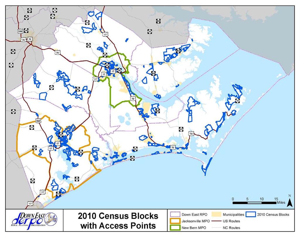
4 A statewide spatial dataset containing employment data by 2010 census blocks was obtained from the NCDOT. This dataset, known as the LEHD Origin-Destination Employment Statistics (LODES) Dataset, was originally obtained from the Longitudinal Employer- Household Dynamics (LEHD) program. The LEHD program is part of the Center for Economic Studies at the US Census Bureau. This program combines federal, state and Census Bureau data on employers and employees under the Local Employment Dynamics (LED) Partnership. Under the LED Partnership, states share the Quarterly Census of Employment and Wages (QCEW) data with the Census Bureau. After obtaining this spatial dataset from NCDOT, only the census blocks with 100 employees or greater which are located in the DERPO were selected. Military & Ports Military locations in the DERPO area were identified using the federal lands in North Carolina spatial dataset downloaded from NC OneMap. Using the original downloaded spatial dataset, federal lands which are in the DERPO area and are military locations were mapped in ArcGIS. Mapped military locations which were identified as US Army Reserve Centers were then removed. The Emerald Isle and Hobucken US Coast Guard Stations were then mapped and therefore added to this spatial dataset. Entry gate or access points from these military locations to the transportation network were then identified. The Port of Morehead City is the only port located in the DERPO area and has only one entry gate. Two NC Ferry routes exist in the DERPO area with three boarding docks in operation. The access points from the dock to the transportation network were identified. Tourism Tourist destinations in the DERPO were identified as the points of interest mapped on the Croatan Regional Bicycle Routes and Trails map. This map is associated with the Croatan Regional Bicycle Plan and Croatan Regional Trails Plan. Both of these plans encompassed a study area that included the five counties which make up the DERPO. These tourist destinations include state and national parks, event centers, museums, historical sites, educational sites, visitor centers, etc. Once all the access points to these locations were identified and mapped, the 2010 US Census Block each access point is contained in was then selected for evaluation and scoring purposes. The maps of these six factors and corresponding Census Blocks are attached.
5
6
7
8
9
10
11
12 The Sub-committee created a hierarchy among these factors. Every occurrence of an access point in a given US Census Block for a Military Installation, NC Port or Ferry Dock is worth 30 points and every US Census Block with 100 employees or greater is worth 30 points. Every access point in a given US Census Block to a Tourist Destination or an Agricultural business is worth 20 points. Every access point in a given US Census Block to a Health Care facility or an Education Center is worth 10 points. Projects of all modes are then mapped to determine their proximity to these identified US Census Blocks containing one or more of the six factors described above. Transportation projects that intersect, parallel or touch one of the selected US Census Blocks containing one of the six factors get a tally of the total points assigned in the scoring hierarchy. Scores are aggregate so every instance is counted towards the total. No project can exceed a maximum of 100 total points. The Qualitative Score will be equal to 50% of the Total Project Score. For example, Project A intersects a Census Block with a Hospital, parallels a Census Block with a Tourists Destination and touches a Census Block at the NC Port so it would get a qualitative score of 30 points. Census Block Score = [(Factor Score + Factor Score + Factor Score) x 100%] x 50% Project A Score: [( ) x 1.0] x 0.5 = 30 Transportation projects that do not intersect, parallel, or touch one of the selected US Census Blocks containing one of the six factors but, are within the same US Census Block Group as those US Census Blocks containing one of the six factors get a tally of 60% of the total points assigned in the scoring hierarchy. Scores are aggregate so every instance is counted towards the total. No project can exceed a maximum of 100 total points. For example, Project B is in a Census Block Group with a College and a Military base so it would get a qualitative score of 12 points. Census Block Group Score = [(Factor Score + Factor Score + Factor Score) x 60%] x 50% Project B Score: [(10+30) x 0.6] x 0.5 = 12 Transportation projects that do not intersect, parallel, or touch one of the selected US Census Blocks containing one of the six factors but, and are not within the same US Census Block Group as those US Census Blocks containing one of the six factors, but are within the same US Census Tract as those US Census Blocks containing one of the six factors get a tally of 30% of the total points assigned in the scoring hierarchy. Scores are aggregate so every instance is counted towards the total. No project can exceed a maximum of 100 total points. For example, Project C is in a Census Tract with an Agricultural center and a Job Center so it would get a qualitative score of 7.5 points. Census Tract Score = [(Factor Score + Factor Score + Factor Score) x 30%] x 50% Project C Score: [(20+30) x 0.3] x 0.5 = 7.5 Once a Quantitative and a Qualitative Score are calculated for every transportation project, those two figures are summed for a Total Project Score.
13 Total Project Score = (Quantitative Score + Qualitative Score) Project A Score: ( ) = At this time projects are eligible for the equivalent of 40% (plus or minus) of the Total Project Score in Discretionary Points. These Discretionary Points are for projects of regional significance or other special consideration, provided that the TAC documents the rationale and that such documentation is available for public inspection. Special considerations included high dollar projects that would overwhelm the funding available for the region, projects that are not far enough along in the planning process to warrant funding, or projects that have strong public support for example. The purpose of these points are to provide local oversight to the data-driven process, to compensate for any peculiar scores where the prioritization methodology fails to operate as expected, and to ensure appropriate projects at the relevant tier. In particular, the Discretionary Points are foreseen as a way to eliminate or downgrade extremely expensive projects at the Division Needs tier where a selected project would overburden Division Needs funds. Since Discretionary points must be agreed upon by the majority of TCC and TAC members, it is envisioned as safety net to correct problems on which there is high concurrence, rather than a way to simply modify the adopted methodology. All projects across all modes are then sorted in descending order from highest score to lowest score for evaluation. The projects are then assigned Local Input Points in descending order starting with the highest scoring project getting the maximum 100 points and the second highest scoring project getting 99 points etc. until the DERPO allotment of 1400 Regional Impact Local Input Points and 1400 Division Needs Local Input Points are exhausted.
BROOKINGS May
 Appendix 1. Technical Methodology This study combines detailed data on transit systems, demographics, and employment to determine the accessibility of jobs via transit within and across the country s 100
Complete Bicycle Network Project Prioritization
 6.3C BICYCLE STUDY PRIORITIES PAGE 6 Appendix C Complete Bicycle Network Project Prioritization This appendix provides a prioritized list of proposed bicycle facilities within each of the municipalities
2014 UTP Public Meeting July 18, 2013
 2014 UTP Public Meeting July 18, 2013 What is the Unified Transportation Program (UTP)? 3 UTP is Updated Annually by August 31st Spring - Summer 2013 UTP 2014 UTP UTP Development Process 4 UTP Connects
OREGON POPULATION FORECAST PROGRAM
 OREGON POPULATION FORECAST PROGRAM PROGRAM OVERVIEW BACKGROUND Beginning in 1973 with the passage of Senate Bill (SB) 100, Oregon s growth management system has relied on population forecasts as the primary
GIS ADMINISTRATOR / WEB DEVELOPER EVANSVILLE-VANDERBURGH COUNTY AREA PLAN COMMISSION
 GIS ADMINISTRATOR / WEB DEVELOPER EVANSVILLE-VANDERBURGH COUNTY AREA PLAN COMMISSION SALARY RANGE INITIATION $43,277 SIX MONTHS $45,367 POSITION GRADE PAT VI The Evansville-Vanderburgh County Area Plan
NC Streambed Mapping Project Issue Paper
 ISSUE 1: The Western North Carolina Drainage Area Requirement Issue Several inquiries and discussions in regard to the determination of the 6-acre drainage area requirement as the upstream limit have been
The Use of Geographic Information Systems (GIS) by Local Governments. Giving municipal decision-makers the power to make better decisions
 by Local Governments. Giving municipal decision-makers the power to make better decisions") The Use of Geographic Information Systems (GIS) by Local Governments Giving municipal decision-makers the power to make better decisions Case Study: Examples of GIS Usage by Local Governments in North
The Use of Geographic Information Systems (GIS) by Local Governments Giving municipal decision-makers the power to make better decisions Case Study: Examples of GIS Usage by Local Governments in North
HORIZON 2030: Land Use & Transportation November 2005
 PROJECTS Land Use An important component of the Horizon transportation planning process involved reviewing the area s comprehensive land use plans to ensure consistency between them and the longrange transportation
Albuquerque City-wide Zoning Remapping
 Albuquerque City-wide Zoning Remapping Michelle Gricius, City of Albuquerque Planning Department Albuquerque Geographic Information System (AGIS) Division City of Albuquerque Annexation History Albuquerque
Transit Time Shed Analyzing Accessibility to Employment and Services
 Transit Time Shed Analyzing Accessibility to Employment and Services presented by Ammar Naji, Liz Thompson and Abdulnaser Arafat Shimberg Center for Housing Studies at the University of Florida www.shimberg.ufl.edu
Kitsap County 2016 Comprehensive Plan Update. Appendix A: Growth Estimates
 Kitsap County 2016 Comprehensive Plan Update Appendix A: Growth Estimates Appendix A 1 April 2016 Kitsap County 2016 Comprehensive Plan Update Appendix A: Growth Estimates Land Capacity Land capacity
Information. Information Technology. Geographic. Services (GIS) 119 W Indiana Ave Deland, FL 32720
 119 W Indiana Ave Deland, FL 32720") Information Technology Geographic Information Services (GIS) 119 W Indiana Ave Deland, FL 32720 A GIS consists of 5 primary components: Hardware Software People Data Methods or Business Processes --- Hardware
Information Technology Geographic Information Services (GIS) 119 W Indiana Ave Deland, FL 32720 A GIS consists of 5 primary components: Hardware Software People Data Methods or Business Processes --- Hardware
Internet GIS Sites. 2 OakMapper webgis Application
 Internet GIS Sites # Name URL Description 1 City of Sugar Land http://www.sugarlandtx.gov/index.htm It is a city in Texas with 65,000 Residents. The City of Sugar Land, Texas, provides ArcIMS-based maps
CLAREMONT MASTER PLAN 2017: LAND USE COMMUNITY INPUT
 Planning and Development Department 14 North Street Claremont, New Hampshire 03743 Ph: (603) 542-7008 Fax: (603) 542-7033 Email: cityplanner@claremontnh.com www.claremontnh.com CLAREMONT MASTER PLAN 2017:
Section 2. Indiana Geographic Information Council: Strategic Plan
 Section 2. Indiana Geographic Information Council: Strategic Plan Introduction A geographic information system (GIS) is an automated tool that allows the collection, modification, storage, analysis, and
John Laznik 273 Delaplane Ave Newark, DE (302)
") Office Address: John Laznik 273 Delaplane Ave Newark, DE 19711 (302) 831-0479 Center for Applied Demography and Survey Research College of Human Services, Education and Public Policy University of Delaware
Office Address: John Laznik 273 Delaplane Ave Newark, DE 19711 (302) 831-0479 Center for Applied Demography and Survey Research College of Human Services, Education and Public Policy University of Delaware
State Geographic Information Consolidation Implementation Plan
 State Geographic Information Consolidation Implementation Plan As Directed by Session Law 2008-0107 Section 6.13 Prepared By: State Chief Information Officer Geographic Information Coordinating Council
An Internet-Based Integrated Resource Management System (IRMS)
") An Internet-Based Integrated Resource Management System (IRMS) Third Quarter Report, Year II 4/1/2000 6/30/2000 Prepared for Missouri Department of Natural Resources Missouri Department of Conservation
An Internet-Based Integrated Resource Management System (IRMS) Third Quarter Report, Year II 4/1/2000 6/30/2000 Prepared for Missouri Department of Natural Resources Missouri Department of Conservation
A Comprehensive Inventory of the Number of Modified Stream Channels in the State of Minnesota. Data, Information and Knowledge Management.
 A Comprehensive Inventory of the Number of Modified Stream Channels in the State of Minnesota Data, Information and Knowledge Management Glenn Skuta Environmental Analysis and Outcomes Division Minnesota
ORTHOPHOTO PROGRAM FREQUENTLY ASKED QUESTIONS
 ORTHOPHOTO PROGRAM FREQUENTLY ASKED QUESTIONS June 4, 2014 Document Purpose The Florida Department of Revenue (DOR) regularly receives questions regarding its orthophoto program. This document answers
OC Enterprise GIS. Kevin Hills, PLS Cameron Smith, GISP. OC Survey
 OC Enterprise GIS Kevin Hills, PLS Cameron Smith, GISP OC Survey Discussion Points Background & Organizational Structure of OCPW Past practices prior to Enterprise Wide GIS License (ELA) Participating
Spatial Organization of Data and Data Extraction from Maptitude
 Spatial Organization of Data and Data Extraction from Maptitude N. P. Taliceo Geospatial Information Sciences The University of Texas at Dallas UT Dallas GIS Workshop Richardson, TX March 30 31, 2018 1/
Neighborhood Locations and Amenities
 University of Maryland School of Architecture, Planning and Preservation Fall, 2014 Neighborhood Locations and Amenities Authors: Cole Greene Jacob Johnson Maha Tariq Under the Supervision of: Dr. Chao
CRP 608 Winter 10 Class presentation February 04, Senior Research Associate Kirwan Institute for the Study of Race and Ethnicity
 CRP 608 Winter 10 Class presentation February 04, 2010 SAMIR GAMBHIR SAMIR GAMBHIR Senior Research Associate Kirwan Institute for the Study of Race and Ethnicity Background Kirwan Institute Our work Using
OTTER POINT ADVISORY PLANNING COMMISSION. Notice of Meeting on Tuesday, June 5, 2018 at 7 p.m.
 OTTER POINT ADVISORY PLANNING COMMISSION Notice of Meeting on Tuesday, June 5, 2018 at 7 p.m. Juan de Fuca Local Area Services Building, #3 7450 Butler Road, Otter Point, BC 1. Elections 2. Approval of
Rural Pennsylvania: Where Is It Anyway? A Compendium of the Definitions of Rural and Rationale for Their Use
 Rural Pennsylvania: Where Is It Anyway? A Compendium of the Definitions of Rural and Rationale for Their Use Pennsylvania Office of Rural Health 310 Nursing Sciences Building University Park, PA 16802
Economic and Social Urban Indicators: A Spatial Decision Support System for Chicago Area Transportation Planning
 Economic and Social Urban Indicators: A Spatial Decision Support System for Chicago Area Transportation Planning Piyushimita Thakuriah (Vonu), P.S. Sriraj, Paul Metaxatos, Inshu Minocha & Tanushri Swarup
Date: June 19, 2013 Meeting Date: July 5, Consideration of the City of Vancouver s Regional Context Statement
 Section E 1.5 To: From: Regional Planning and Agriculture Committee Lee-Ann Garnett, Senior Regional Planner Planning, Policy and Environment Department Date: June 19, 2013 Meeting Date: July 5, 2013 Subject:
Demographic Data in ArcGIS. Harry J. Moore IV
 Demographic Data in ArcGIS Harry J. Moore IV Outline What is demographic data? Esri Demographic data - Real world examples with GIS - Redistricting - Emergency Preparedness - Economic Development Next
GIS for Integrated Pest Management. Christina Hailey. Abstract:
 GIS for Integrated Pest Management Christina Hailey Abstract: At its formation in 1965, Harris County Mosquito Control (Houston, Texas) (HCMC) was primarily involved in the prevention and control of mosquito-borne
Economic Activity Economic A ctivity
 5 Economic Economic Activity Activity ECONOMIC ACTIVITY 5.1 EMPLOYMENT... 5-7 5.1.1 OBJECTIVE... 5-7 5.1.2 POLICIES... 5-7 5.2 PROTECTING THE AREA OF EMPLOYMENT... 5-9 5.2.1 OBJECTIVE... 5-9 5.2.2 POLICIES...
Planning for Economic and Job Growth
 Planning for Economic and Job Growth Mayors Innovation Project Winter 2012 Meeting January 21, 2012 Mary Kay Leonard Initiative for a Competitive Inner City AGENDA The Evolving Model for Urban Economic
Creating a Pavement Management System Using GIS
 Christopher Castruita PPD 631 Prof. Barry Waite & Prof. Bonnie Shrewsbury Creating a Pavement Management System Using GIS Problem Definition As is the case with many cities, the city of La Cañada Flintridge
An Assessment of People, Place and Business on Syracuse s Near Northside
 An Assessment of People, Place and Business on Syracuse s Near Northside May 2013 Report produced by Jon Glass, Kelly Montague and Mark Pawliw Edited by Jon Glass and Jonnell Robinson Syracuse Community
City of Chino Hills General Plan Update 13GPA02 Scoping Meeting. June 4, 2013
 13GPA02 Scoping Meeting June 4, 2013 Every California city must adopt a comprehensive, long-term general plan. The General Plan is the City s constitution or blueprint for its long-range physical development.
HAZUS-MH: Earthquake Event Report
 HAZUS-MH: Earthquake Event Report Region Name: El Paso County Earthquake Scenario: El Paso County Random EQ Print Date: February 08, 2006 Disclaimer: The estimates of social and economic impacts contained
Geospatial Analysis of Job-Housing Mismatch Using ArcGIS and Python
 Geospatial Analysis of Job-Housing Mismatch Using ArcGIS and Python 2016 ESRI User Conference June 29, 2016 San Diego, CA Jung Seo, Frank Wen, Simon Choi and Tom Vo, Research & Analysis Southern California
INDOT Office of Traffic Safety
 Intro to GIS Spatial Analysis INDOT Office of Traffic Safety Intro to GIS Spatial Analysis INDOT Office of Traffic Safety Kevin Knoke Section 130 Program Manager Highway Engineer II Registered Professional
FHWA Planning Data Resources: Census Data Planning Products (CTPP) HEPGIS Interactive Mapping Portal
 HEPGIS Interactive Mapping Portal") FHWA Planning Data Resources: Census Data Planning Products (CTPP) HEPGIS Interactive Mapping Portal Jeremy Raw, P.E. FHWA, Office of Planning, Systems Planning and Analysis August 2017 Outline Census
FHWA Planning Data Resources: Census Data Planning Products (CTPP) HEPGIS Interactive Mapping Portal Jeremy Raw, P.E. FHWA, Office of Planning, Systems Planning and Analysis August 2017 Outline Census
The Tampa Bay Catastrophic Plan Presentation to CFGIS Users Group FDOT District 5 Urban Offices - Orlando July 30, 2010
 The Tampa Bay Catastrophic Plan Presentation to CFGIS Users Group FDOT District 5 Urban Offices - Orlando July 30, 2010 Brady Smith Senior Planner Tampa Bay Regional Planning Council Introduction Recent
WICHITA FALLS METROPOLITAN PLANNING ORGANIZATION
 WICHITA FALLS METROPOLITAN PLANNING ORGANIZATION Urban Transportation Study ANNUAL PERFORMANCE and EXPENDITURE REPORT Fiscal Year 2014 October 1, 2013 to September 30, 2014 Prepared by the Wichita Falls
KENTUCKY HAZARD MITIGATION PLAN RISK ASSESSMENT
 KENTUCKY HAZARD MITIGATION PLAN RISK ASSESSMENT Presentation Outline Development of the 2013 State Hazard Mitigation Plan Risk Assessment Determining risk assessment scale Census Data Aggregation Levels
Safety Guidelines for the Chemistry Professional: Understanding Your Role and Responsibilities
 Safety Guidelines for the Chemistry Professional: Understanding Your Role and Responsibilities Kenneth P. Fivizzani Committee on Chemical Safety/ Division of Chemical Health & Safety August 22, 2017 Introduction
Creating a Staff Development Plan with Esri
 Creating a Staff Development Plan with Esri Michael Green David Schneider Guest Presenter: Shane Feirer, University of California Esri UC 2014 Technical Workshop Agenda What is a Staff Development Plan?
TREASURE COAST REGIONAL PLANNING COUNCIL M E M O R A N D U M. To: Council Members AGENDA ITEM 4B10
 TREASURE COAST REGIONAL PLANNING COUNCIL M E M O R A N D U M To: Council Members AGENDA ITEM 4B10 From: Date: Subject: Staff December 14, 2018 Council Meeting Local Government Comprehensive Plan Review
Law on Spatial Planning
 UNITED NATIONS United Nations Interim Administration Mission in Kosovo UNMIK NATIONS UNIES Mission d Administration Intérimaire des Nations Unies au Kosovo PROVISIONAL INSTITUTIONS OF SELF GOVERNMENT Law
King Fahd University of Petroleum & Minerals College of Engineering Sciences Civil Engineering Department. Geographical Information Systems(GIS)
") King Fahd University of Petroleum & Minerals College of Engineering Sciences Civil Engineering Department Geographical Information Systems(GIS) Term Project Titled Delineating Potential Area for Locating
King Fahd University of Petroleum & Minerals College of Engineering Sciences Civil Engineering Department Geographical Information Systems(GIS) Term Project Titled Delineating Potential Area for Locating
Report from the Geographic Information Coordinating Council
 Report from the Geographic Information Coordinating Council Presented by: Dr. Lee Mandell, Chair North Carolina Geographic Information Coordinating Council What is GIS? Geography plays a role in nearly
Policy Paper Alabama Primary Care Service Areas
 Aim and Purpose Policy Paper Alabama Primary Care Service Areas Produced by the Office for Family Health Education & Research, UAB School of Medicine To create primary care rational service areas (PCSA)
Exploring GIS Potential for Northwestern Ontario Land Information Ontario
 Exploring GIS Potential for Northwestern Ontario Land Information Ontario May 13, 2015 The LIO Vision LIO Vision: That all geographic information about Ontario is fully integrated and accessible LIO Goal:
2010 Census Data Release and Current Geographic Programs. Michaellyn Garcia Geographer Seattle Regional Census Center
 2010 Census Data Release and Current Geographic Programs Michaellyn Garcia Geographer Seattle Regional Census Center 2010 Center of Population Located approximately 2.7 miles northeast of Plato, Missouri
CERTIFIED RESOLUTION. introduction: and dated May 29, 2017, as attached, as appropriate
 15322 Buena Vista Avenue, White Rock BC, Canada V4B 1Y6 www.whiterockcity.ca City of White Rock P: 604.541.22121 F: 604.541.9348 /2tC% City Clerk s Office IT E ROC K June 13,2017 Stephanie Lam, Deputy
Summary Description Municipality of Anchorage. Anchorage Coastal Resource Atlas Project
 Summary Description Municipality of Anchorage Anchorage Coastal Resource Atlas Project By: Thede Tobish, MOA Planner; and Charlie Barnwell, MOA GIS Manager Introduction Local governments often struggle
2018 NASCIO Award Submission Category: Cross-Boundary Collaboration and Partnerships. Project Title: Tennessee Wildfires: A Coordinated GIS Response
 2018 NASCIO Award Submission Category: Cross-Boundary Collaboration and Partnerships Project Title: Tennessee Wildfires: A Coordinated GIS Response Sevier County, Tennessee State of Tennessee, Emergency
Using American Factfinder
 Using American Factfinder What is American Factfinder? American Factfinder is a search engine that provides access to the population, housing and economic data collected by the U.S. Census Bureau. It can
GIS in Community & Regional Planning
 GIS in Community & Regional Planning The The role role of of GIS GIS in in Re-writing the the Zoning Bylaw for for the the City City of of Vernon LandInfo Technologies Presentation Overview The GIS Initiative
Local Area Key Issues Paper No. 13: Southern Hinterland townships growth opportunities
 Draft Sunshine Coast Planning Scheme Review of Submissions Local Area Key Issues Paper No. 13: Southern Hinterland townships growth opportunities Key Issue: Growth opportunities for Southern Hinterland
Population Research Center (PRC) Oregon Population Forecast Program
 Oregon Population Forecast Program") Population Research Center (PRC) Oregon Population Forecast Program 2013 Oregon League of Cities Conference Risa S. Proehl Jason R. Jurjevich, Ph.D. Population Research Center (PRC) Population Research
Population Research Center (PRC) Oregon Population Forecast Program 2013 Oregon League of Cities Conference Risa S. Proehl Jason R. Jurjevich, Ph.D. Population Research Center (PRC) Population Research
US National Spatial Data Infrastructure A Spatial Framework for Governance and Policy Development to Enable a Location-Based Digital Ecosystem
 GeoPlatform Workshop 7 Dec 2016, Department of the Interior Washington, D.C. US National Spatial Infrastructure A Spatial Framework for Governance and Policy Development to Enable a Location-Based Digital
The GIS Path Forward Saskatchewan s Geomatics Strategic Plan
 The GIS Path Forward Saskatchewan s Geomatics Strategic Plan John Potter, SK Ministry of Central Services Office of Geomatics Coordination Sept.17/13 Table of Contents 1. 2011-2016, Geomatics Strategic
The Kentucky Mesonet: Entering a New Phase
 The Kentucky Mesonet: Entering a New Phase Stuart A. Foster State Climatologist Kentucky Climate Center Western Kentucky University KCJEA Winter Conference Lexington, Kentucky February 9, 2017 Kentucky
CALOTS Upgrade for Performance Monitoring
 CALOTS Upgrade for Performance Monitoring A project of the Southern California Association of Governments supported by the UCLA Lewis Center for Regional Policy Studies Agenda 1. Revisit Project Overview
SDI Development in Georgia. Mari Khardziani Head of International Relations Unit National Agency of Public Registry
 SDI Development in Georgia Mari Khardziani Head of International Relations Unit National Agency of Public Registry Kehl, Germany September 5, 2017 2 National Agency of Public Registry Legal Entity of Public
Rural Louisiana. A quarterly publication of the Louisiana Tech Rural Development Center
 Rural Louisiana A quarterly publication of the Louisiana Tech Rural Development Center Volume 4, No. 1, Fall 2009 Editor: Aaron K. Lusby Director, Asst. Professor Newsletter design: Stephanie Tidwell Student
State GIS Officer/GIS Data
 State GIS Officer/GIS Data This Act creates the position of state Geographic Information Systems (GIS) officer. The Act: requires the state GIS officer to adopt or veto the GIS data standards and a statewide
Hurricane Preparation and Recovery. October 11, 2011 Jon Nance, Chief Engineer, NCDOT
 Hurricane Preparation and Recovery October 11, 2011 Jon Nance, Chief Engineer, NCDOT North Carolina & Severe Weather Our state often bears the brunt of storms, which include: Ice storms Snow storms Heavy
SOUTH DAKOTA BOARD OF REGENTS. Academic and Student Affairs ******************************************************************************
 SOUTH DAKOTA BOARD OF REGENTS Academic and Student Affairs AGENDA ITEM: 7 C (4) DATE: June 28-30, 2016 ****************************************************************************** SUBJECT: New Minor:
Application #: TEXT
 TOWN OF FORT MYERS BEACH 2008 PROPOSED COMPREHENSIVE PLAN AMENDMENTS Application #: 2008-13-TEXT Description: Modify the Coastal Management and Future Land Use Elements to reflect the state s new definition
2013 NASCIO Award Submission Category: Cross-Boundary Collaboration and Partnerships. Project Title: Public Safety and Enterprise GIS in Tennessee
 2013 NASCIO Award Submission Category: Cross-Boundary Collaboration and Partnerships Project Title: Public Safety and Enterprise GIS in Tennessee State of Tennessee, Board of Parole State of Tennessee,
A User s Guide to the Federal Statistical Research Data Centers
 A User s Guide to the Federal Statistical Research Data Centers Mark Roberts Professor of Economics and Director PSU FSRDC September 2016 M. Roberts () RDC User s Guide September 2016 1 / 14 Outline Introduction
Non-Motorized Traffic Exploratory Analysis
 Non-Motorized Traffic Exploratory Analysis --------------------------------------------------------------- Chao Wu Advisor: Professor Greg Lindsey Humphrey School of Public Affairs University of Minnesota
The econ Planning Suite: CPD Maps and the Con Plan in IDIS for Consortia Grantees Session 1
 The econ Planning Suite: CPD Maps and the Con Plan in IDIS for Consortia Grantees Session 1 1 Training Objectives Use CPD Maps to analyze, assess, and compare levels of need in your community Use IDIS
Study Overview. the nassau hub study. The Nassau Hub
 Livable Communities through Sustainable Transportation the nassau hub study AlternativeS analysis / environmental impact statement The Nassau Hub Study Overview Nassau County has initiated the preparation
ADDRESSING TITLE VI AND ENVIRONMENTAL JUSTICE IN LONG-RANGE TRANSPORTATION PLANS
 ADDRESSING TITLE VI AND ENVIRONMENTAL JUSTICE IN LONG-RANGE TRANSPORTATION PLANS Activities from the National Capital Region Transportation Planning Board Sergio Ritacco Transportation Planner 2017 Association
Oregon Department of Transportation. Geographic Information Systems Strategic Plan
 Oregon Department of Transportation Geographic Information Systems Strategic Plan Adopted May, 2000 By the GIS Steering Committee Last printed 10/2/2012 4:20:00 PM Page Geographic Information Systems Strategic
Land Use and Zoning Page 1 of 10 LAND USE AND ZONING
 LAND USE AND ZONING Land Use and Zoning Page 1 of 10 BACKGROUND The Clifton-Fruitvale planning area is about 3,962 acres (6.2 sq. miles) with a population of 14,000 residents. The density of the area is
Agenda Item B /20 Strategic Budget Development Phase I Preliminary Recommendations
 Agenda Item B-24 2019/20 Strategic Budget Development Phase I Preliminary Recommendations Board of Education February 13, 2019 2 Outline Preliminary Recommendations and Discussions School Staffing School
Enhancing Louisiana s GNIS
 Enhancing Louisiana s GNIS An Outreach Effort Between USGS and the Louisiana Geographic Information Center Louisiana Remote Sensing and GIS Workshop Lafayette, LA April 28, 2010 Louisiana Geographic Information
CHAPTER 7 PRODUCT USE AND AVAILABILITY
 CHAPTER 7 PRODUCT USE AND AVAILABILITY Julie Prior-Magee Photo from SWReGAP Training Site Image Library Recommended Citation Prior-Magee, J.S. 2007. Product use and availability. Chapter 7 in J.S. Prior-Magee,
City of Hermosa Beach Beach Access and Parking Study. Submitted by. 600 Wilshire Blvd., Suite 1050 Los Angeles, CA
 City of Hermosa Beach Beach Access and Parking Study Submitted by 600 Wilshire Blvd., Suite 1050 Los Angeles, CA 90017 213.261.3050 January 2015 TABLE OF CONTENTS Introduction to the Beach Access and Parking
OFFICIAL GAZETTE OF THE REPUBLIC OF KOSOVA / No. 30 / 23 AUGUST 2013, PRISTINA LAW NO. 04/L-174 ON SPATIAL PLANNING LAW ON SPATIAL PLANNING
 OFFICIAL GAZETTE OF THE REPUBLIC OF KOSOVA / No. 30 / 23 AUGUST 2013, PRISTINA LAW NO. 04/L-174 ON SPATIAL PLANNING Assembly of Republic of Kosovo; Pursuant to Article 65 (1) of the Constitution of Republic
City and SUMP of Ravenna
 City and SUMP of Ravenna Nicola Scanferla Head of Mobility Planning Unit, Municipality of Ravenna nscanferla@comune.ra.it place your logo here 19 April, 2017 1st Steering Committee Meeting, Nicosia, Cyprus
Internal Audit Report
 Internal Audit Report Right of Way Mapping TxDOT Internal Audit Division Objective To determine the efficiency and effectiveness of district mapping procedures. Opinion Based on the audit scope areas reviewed,
The purpose of this report is to recommend a Geographic Information System (GIS) Strategy for the Town of Richmond Hill.
 Strategy for the Town of Richmond Hill.") Staff Report for Committee of the Whole Meeting Department: Division: Subject: Office of the Chief Administrative Officer Strategic Initiatives SRCAO.18.12 GIS Strategy Purpose: The purpose of this report
Staff Report for Committee of the Whole Meeting Department: Division: Subject: Office of the Chief Administrative Officer Strategic Initiatives SRCAO.18.12 GIS Strategy Purpose: The purpose of this report
Regional Transit Development Plan Strategic Corridors Analysis. Employment Access and Commuting Patterns Analysis. (Draft)
") Regional Transit Development Plan Strategic Corridors Analysis Employment Access and Commuting Patterns Analysis (Draft) April 2010 Contents 1.0 INTRODUCTION... 4 1.1 Overview and Data Sources... 4 1.2
Regional Transit Development Plan Strategic Corridors Analysis Employment Access and Commuting Patterns Analysis (Draft) April 2010 Contents 1.0 INTRODUCTION... 4 1.1 Overview and Data Sources... 4 1.2
CHAPTER 22 GEOGRAPHIC INFORMATION SYSTEMS
 CHAPTER 22 GEOGRAPHIC INFORMATION SYSTEMS PURPOSE: This chapter establishes the administration and use of to improve the quality and accessibility of Department s spatial information and support graphical
Wasatch Front Region Small Area Socioeconomic Forecasts: Technical Report #49
 Regional Transportation Plan: 2011-2040 Appendix A APPENDIX A Wasatch Front Region Small Area Socioeconomic Forecasts: 2007-2040 Technical Report #49 July, 2010 295 N. Jimmy Doolittle Road Salt Lake City,
KING GEORGE COUNTY DEPARTMENT OF COMMUNITY DEVELOPMENT
 GIS REPORT 2017 KING GEORGE COUNTY DEPARTMENT OF COMMUNITY DEVELOPMENT Background The GIS (Geographic Information System) manager was hired in 2001 to develop a GIS for King George County. Prior to 2001,
Accessibility analysis of multimodal transport systems using advanced GIS techniques
 Urban Transport XIII: Urban Transport and the Environment in the 21st Century 655 Accessibility analysis of multimodal transport systems using advanced GIS techniques T. Vorraa Citilabs Regional Director,
FIRE DEPARMENT SANTA CLARA COUNTY
 DEFINITION FIRE DEPARMENT SANTA CLARA COUNTY GEOGRAPHIC INFORMATION SYSTEM (GIS) ANALYST Under the direction of the Information Technology Officer, the GIS Analyst provides geo-spatial strategic planning,
IMPLEMENTING GOVERNMENT-WIDE ENTERPRISE GIS; THE FEDERATED MODEL
 IMPLEMENTING GOVERNMENT-WIDE ENTERPRISE GIS; THE FEDERATED MODEL James E. Mitchell, Ph. D. IT GIS Manager Louisiana Department of Transportation and Development presented at the ESRI International Users
Economic Geography of the Long Island Region
 Geography of Data Economic Geography of the Long Island Region Copyright 2011 AFG 1 The geography of economic activity requires: - the gathering of spatial data - the location of data geographically -
BROADBAND DEMAND AGGREGATION: PLANNING BROADBAND IN RURAL NORTHERN CALIFORNIA
 BROADBAND DEMAND AGGREGATION: PLANNING BROADBAND IN RURAL NORTHERN CALIFORNIA Steven J. Steinberg, Ph.D a,b, *, Rebecca Degagne a, M.S., Michael Gough a a Institute for Spatial Analysis, Humboldt State
COMMUNITY SERVICE AREA
 INSTITUTE FOR TRIBAL ENVIRONMENTAL PROFESSIONALS Tribal Waste and Response Assistance Program (TWRAP) Developing and Implementing a Tribal Integrated Solid Waste Management Plan April 12-14, 2016 Palm
The Indiana Data Sharing Initiative and the IndianaMap. Cross-Boundary Collaboration and Partnerships. State of Indiana
 The Indiana Data Sharing Initiative and the IndianaMap Cross-Boundary Collaboration and Partnerships State of Indiana Brian Arrowood, CIO James Sparks, GIO EXECUTIVE SUMMARY Under the collaboration oriented
Updating the Urban Boundary and Functional Classification of New Jersey Roadways using 2010 Census data
 Updating the Urban Boundary and Functional Classification of New Jersey Roadways using 2010 Census data By: Glenn Locke, GISP, PMP 1 GIS-T May, 2013 Presentation Overview Purpose of Project Methodology
MPC-425 January 1, December 31, 2013
 MPC-425 January 1, 2013- December 31, 2013 Project Title: Building a Sustainable GIS Framework for Supporting a Tribal Transportation Program University: North Dakota State University Principal Investigators:
Spatiotemporal Analysis of Commuting Patterns: Using ArcGIS and Big Data
 Spatiotemporal Analysis of Commuting Patterns: Using ArcGIS and Big Data 2017 ESRI User Conference July 13, 2017 San Diego, VA Jung Seo, Tom Vo, Frank Wen and Simon Choi Research & Analysis Southern California
Dark Sky Initiative Draft Terms of Reference
 Dark Sky Initiative Draft Terms of Reference July 2008 Table of Contents 1.0 Introduction 2 2.0 Initiative intent 2-3 3.0 Initiative goals 3 4.0 Legislation 3 5.0 Municipal Development Plan 3 6.0 Land
GIS Spatial Statistics for Public Opinion Survey Response Rates
 GIS Spatial Statistics for Public Opinion Survey Response Rates July 22, 2015 Timothy Michalowski Senior Statistical GIS Analyst Abt SRBI - New York, NY t.michalowski@srbi.com www.srbi.com Introduction