Lecture 1-3: Understanding of GIS
|
|
|
- Bethany Brown
- 5 years ago
- Views:
Transcription


,")
1 Geographic Information System (GIS) Lecture 1-3: Understanding of GIS By: Md. ESRAZ-Ul-Zannat Assistant Professor Department of Urban and Regional Planning Khulna University of Engineering and Technology (KUET), Khulna-9203, Bangladesh Date: 17 December
2 Acknowledgement 2 These slides are aggregations for better understanding of the topic mentioned in the previous slide. I acknowledge the contribution of all the authors and photographers from where I tried to accumulate the info and used for better presentation.
3 Topics to be Covered by this Presentation 3 Understanding GIS (All about GIS) Defining GIS Hierarchy of decision-making infrastructure Geo-science, technology and business goals of applied problem solving GIS History Components of GIS
4 Quotes Regarding GIS The most incomprehensible thing about the world is that it is comprehensible. Albert Einstein "Knowing where things are, and why, is essential to rational decision making" Jack Dangermond, Environmental Systems Research Institute (ESRI) "Everything is related to everything else, but near things are more related than distant things. - Tobler's First Law of Geography (1970) Everything happens somewhere. GIS is the nervous system for the planet. - Jack Dangermond Question: Why can fish measure distances so well? Answer: Because they have their own scales. 4
5 Quotes regarding GIS The new source of power is not money in the hands of a few but information in the hands of many. John Naisbitt A decision is as good as the information that goes into it. John F. Bookout, Jr. No matter where you go, there you are. Anonymous A picture is worth a thousand words. Chinese proverb 5

6 Almost everything that happens, happens somewhere! We share the same geography and are related! Think about all the activity occurring though out a landscape. How can we map, manage and analyze all that is going on? GIS! ROWAN UNIVERSITY 6

7 GIS Integrate Data 7
8 Almost everything that happens, happens somewhere! *We are confined in our activities to the surface and near surface of the Earth. *We travel over it and in the lower levels of the atmosphere. *Through tunnels dug just below the surface. *We dig ditches and burry pipelines and cables *Construct mines to extract mineral deposits *Drill wells to access oil and gas. *Keeping track of all this activity is important, and knowing where it occurs can be the most convenient basis for tracking. Knowing where something happens is critically important! If we want go there ourselves or send someone there, to find other information about the same place, or to inform people nearby 8
9 All About GIS Geographic information systems are a special class of information systems that keep track not only of events, activities, and things happen or exist, but also of where these events, activities, and things happen or exist. Definitions of GIS can vary considerably! Why do we need GIS? Because location is important, It is an issue in many of the problems society must solve. Problems that involve an aspect of location, either in the information used to solve them, or in the solutions themselves, are termed geographic problems 9
10 All About GIS 10
11 All About GIS 11

12 All About GIS 12

13 All About GIS 13
 is the science that studies the lands, the features, the inhabitants, and the phenomena of the Earth.")
 Geography as a discipline can be split broadly into two main subsidiary fields: the human geography and the physical geography.")

14 G I S.. G derived from Geography Geography Geography (from Greek geographia, lit. "earth description) is the science that studies the lands, the features, the inhabitants, and the phenomena of the Earth. A literal translation would be "to describe or write about the Earth". The first person to use the word "geography" was Eratosthenes ( BC). Eratosthenes ( BC) Geography as a discipline can be split broadly into two main subsidiary fields: the human geography and the physical geography. Physical geography (or physiography) focuses on geography as an Earth science. It aims to understand the physical problems and the issues of lithosphere, hydrosphere,atmosphere, pedosphere, and global flora and fauna patterns (biosphere). Human geography is a branch of geography that focuses on the study of patterns and processes that shape the human society. It encompasses the human, political, cultural,social, and economic aspects. 14

 only has this variant, though I am not American and so I will leave it to an American to confirm this.")
.")
15 Geographic vs. Geographical Geographic This term is used to describe the geography of our Earth, the geography that most laypeople think of when they hear the word geography things such as topography, topology, navigation, orientation, and mapwork. By this definition, your location in a place is geographic, not geographical. The sense of this word is tied quite closely to the physical world. It is possible that AE (American English) only has this variant, though I am not American and so I will leave it to an American to confirm this. American leader in GIS chooses Geographic Information Systems, though GIS may be used for geographic or geographical analysis. This form is also found in the National Geographic Society (also famous for their magazine and television channels). Geographical This word is more holistic in terms of gathering all the different aspects of geography, not simply maps and physical systems of rivers, rocks, and mountains. The word is used in more professional capacity because of this. Your location in space might be geographical in light of this. md. ESRAZ-ul-zannat, Urban Planner & GIS/RS Specialist, esrazuz@gmail.com, cell:
16 Principles of GIS Acronym GIS = geographic information system the hardware, software, & routines GIS = geographic information science philosophical questions methods issues Why does it matter? Discipline specific implications software versus science 16
17 A GIS... 17
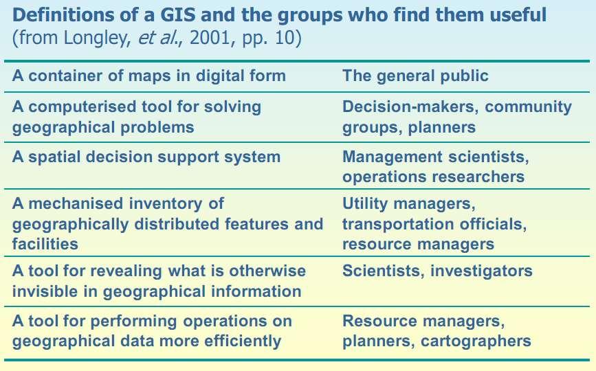
18 A GIS... Definitions of GIS vary considerably! 18 A container of maps in digital form A computerized tool for solving geographic problems A spatial decision support system A mechanized inventory of geographically distributed features and facilities A tool for revealing what is otherwise invisible in geographic information A tool for performing operations on geographic data that are too tedious or expensive or inaccurate if performed by hand
19 A GIS... is a subset of information science that deals with spatially or geographically referenced data. Is a collection of hardware, software, methods, and instructions, to: capture, manage, manipulate, analyze, & display Is a decision support system Is different from mapping & computer aid-cartography because of its analytical capacity Is different from CAD programs because it performs spatial operations Is different from DBMS because it has a cartographic interface 19
20 GIS: An Inter-disciplinary Science Geography Cartography Photogrammetry Remote Sensing Geology Geodesy Surveying Statistics MIS Computer Science Mathematics Civil Engineering 20
21 Similar & Synonymous Software Applications/Terms AGIS (Automated Geographic Information System), AM/FM (Automated Mapping and Facilities Management) CAD/M (Computer-Aided Drafting/Mapping or Manufacturing) Environmental Information System Image-Based Information System LIS (Land Information System) Land Management System Land Record System Land Resources Information System Natural Resources Inventory System Natural Resources Management Information System Planning Information System Multipurpose Cadastre Resource Information System Spatial Data Handling System 21
22 All About GIS Interpretation of the words G I S GIS: A particular form of information system applied to geographical data A system: A group of connected entities and activities which interact for a common purpose An information system: A set of processes, executed on raw data, to produce information which will be useful for decision making Geographical data: Spatially referenced data sets 22
23 All About GIS 23

24 What is an Information System? In the digital environment we use software to create complex information systems. 24
25 What is a GIS? Information System + Geographic Position A means of storing, retrieving, sorting, and comparing spatial data to support some analytic process. 25

 to")
26 What is a GIS? GEOGRAPHIC Information System GIS links graphical features (entities) to tabular data (attributes) 26
27 GIS Answers... What is the population of a particular city? What are the characteristics of the soils in a particular land parcel? Are there any trends of earthquake in a particular zone which could help predict future quakes? How has the distribution of rural and urban population changed between the past two censuses? To answer such questions proper and accurate data are required from different sources and these data should be integrated into consistent forms. 27
28 Examples of Geographic Problems *Health care managers solve geographic problems Where to locate new clinics and hospitals *Delivery companies solve geographic problems when they decide the routes, and schedules of their vehicles, often on a daily basis. *Transportation authorities solve geographic problems When they select routes for new highways *Forestry companies: They determine how best to manage forests, etc. Governments solve geographic problems when they decide how to allocate funds for building sea defense 28
29 Spatial problem solving Information systems help us to manage what we know by making it easy to organize and store, access and retrieve, manipulate and synthesise, and apply to the solution of problems. (Longley, et al., 2011) Data: raw facts Information: contents assembled from raw facts Evidence: results of analysis Knowledge: information that is understood Wisdom: Policies developed and accepted 29
30 Hierarchy of decision-making infrastructure Decision-making support infrastructure Ease of sharing with everyone GIS example Wisdom Impossible Policies developed and accepted by stakeholders Knowledge Difficult Personal knowledge about places and issues Evidence Often not easy Results of GIS analysis Information Easy Contents assembled from raw facts Data Easy Raw geographical facts (After Longley, et al., 2011, pp. 12) 30
31 Geo-science, technology and business Geo-science: knowledge about how the world works Information on how it looks, its forms and how it works Prediction GIS combines general scientific knowledge with specific information, and gives practical value to both. The test-bed for geography Geo-technology: to support both science and problem solving. Geo-business: software, data, geo-service, publishing and education 31
32 What are the goals of applied problem solving? GIS is fundamentally about solving real-world problems. - Rational, effective, and efficient allocation of resources, for example physical construction of infrastructure - Monitoring and understanding observed spatial distributions of attributes, such as the geography of environmental health - Understanding the difference that place makes, identifying which characteristics are inherently similar between places, and what is distinctive and possibly unique about them For example, regional and local differences in alcohol consumption - Understanding of processes in the natural and human environments, such as processes of coastal erosion or river delta deposition in the natural environment - Prescription of strategies for environmental maintenance and conservation, as in national park management 32
33 GIS can be applied to solve many problem Rhind (1990) sets out a general classification of generic questions: 1. Location What is at? 2. Condition Where is it? 3. Trend What has change? 4. Routing Which is the best way? 5. Pattern What is the Pattern? 6. Modelling What if? 33
 In 1854, John Snow depicted a cholera outbreak in London using points to represent the locations of some individual cases, possibly the earliest use of the geographic")
34 GIS Past. (History of GIS Development) In 1854, John Snow depicted a cholera outbreak in London using points to represent the locations of some individual cases, possibly the earliest use of the geographic method. His study of the distribution of cholera led to the source of the disease, a contaminated water pump (the Broad Street Pump, whose handle he had disconnected, thus terminating the outbreak) within the heart of the cholera outbreak. E. W. Gilbert's version (1958) of John Snow's 1855 map of the Soho cholera outbreak showing the clusters of cholera cases in the London epidemic of While the basic elements of topography and theme existed previously in cartography, the John Snow map was unique, using cartographic methods not only to depict but also to analyze clusters of geographically dependent phenomena for the first time. Fig shows A variant of the original map drawn by Dr. John Snow ( ), a British physician who is one of the founders of medical epidemiology, showing cases of cholera in the London epidemics of 1854, clustered around the locations of water pumps. 34

35 US Census Data in Excel Think about keeping information about phenomenon on a landscape. How could you do it? 35


36 US Census Data in GIS GIS organizes that data with a map. But GIS is much more. 36

37 GIS Functions 37
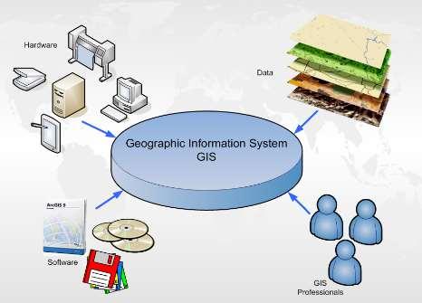
38 What is GIS? A Geographic Information System, or GIS, is an organized collection of computer hardware, software, geographic data, and personnel designed to efficiently capture, store, update, manipulate, analyze, and display all forms of geographically referenced information. Or, in simple terms: A computer system capable of holding and using data describing places on the earth's surface. GIS is an acronym for Geographic Information System. This is basically a computerized system for managing and viewing large amounts of information geographically. A geographic information system (GIS) integrates hardware, software, and data for capturing, managing, analyzing, and displaying all forms of geographically referenced information. Practitioners also regard the total GIS as including operating personnel and the data that go into the system. 38
39 GISystem Data acquisition GIS Data query Geographical database Data analysis Presentation 39
40 What is GIS? In short A Geographical Information System (GIS) is a collection of maps, tables and various data pulled together to interact with each other to help present realities, scenarios and information in a graphical manner. Remember, a picture is worth a thousand words. 40

41 What is GIS? GIS stands for Geographic Information Systems. GIS is a System or a Tool for - collecting, - storing, - manipulating, - analyzing, - displaying, and - querying geographically related information. It is important to understand that GIS is a system, not a specific software. 41

42 What is GIS? Definitions of GIS can vary considerably!!! 42
43 What is GIS? Capturing Data: A GIS must provide methods for inputting geographic (coordinate) or tabular (attribute) data. The more input methods available, the more versatile the GIS. Storing Data: There are two basic data models for geographic data storage: vector and raster. A GIS should be able to store geographic data in both models. Querying data: A GIS must provide utilities for finding specific features based on location or attribute value. Analyzing data: A GIS must be able to answer questions regarding the interaction of spatial relationships between multiple data sets. Displaying Data: A GIS must have tools for visualizing geographic features using a variety of symbology. Output: A GIS must be able to display results in a variety of formats, such as maps, reports, and graphs 43
44 What is GIS? Spatial Data Modeling Visualization Spatial Data & Attribute Data Spatial Analysis & Spatial modeling Database Management System 44

45 GIS is Composed of? 45
46 Components of GIS 46
47 5 Components of GIS? 1. People: This is the most important component in a GIS. People must develop the procedures and define the tasks of the GIS. People can often overcome shortcomings in other components of the GIS, but the best software and computers in the world cannot compensate for the incompetence of people. 2. Data: The availability and accuracy of data can affect the results of any query or analysis. 3. Hardware: hardware capabilities affect processing speed, ease of use, and the type of output 4. Software: This includes not only actual GIS software, but also various database, drawing, statistical, imaging, or other software. 5. Procedures or Methods: Analysis requires well-defined, consistent methods to produce accurate, reproducible results 47
48 Topics Covered by this Presentation 48 Understanding GIS (All about GIS) Defining GIS Hierarchy of decision-making infrastructure Geo-science, technology and business goals of applied problem solving GIS History Components of GIS
49 What We Learnt Understanding of the very basic of GIS with different examples 49
50 50

51 51
52 52 What Next? Lecture 04-07: Applications of GIS
GIS = Geographic Information Systems;
 What is GIS GIS = Geographic Information Systems; What Information are we talking about? Information about anything that has a place (e.g. locations of features, address of people) on Earth s surface,
Geographical Information System (GIS) Prof. A. K. Gosain
 Prof. A. K. Gosain") Geographical Information System (GIS) Prof. A. K. Gosain gosain@civil.iitd.ernet.in Definition of GIS GIS - Geographic Information System or a particular information system applied to geographical data
Geographical Information System (GIS) Prof. A. K. Gosain gosain@civil.iitd.ernet.in Definition of GIS GIS - Geographic Information System or a particular information system applied to geographical data
FUNDAMENTALS OF GEOINFORMATICS PART-II (CLASS: FYBSc SEM- II)
") FUNDAMENTALS OF GEOINFORMATICS PART-II (CLASS: FYBSc SEM- II) UNIT:-I: INTRODUCTION TO GIS 1.1.Definition, Potential of GIS, Concept of Space and Time 1.2.Components of GIS, Evolution/Origin and Objectives
FUNDAMENTALS OF GEOINFORMATICS PART-II (CLASS: FYBSc SEM- II) UNIT:-I: INTRODUCTION TO GIS 1.1.Definition, Potential of GIS, Concept of Space and Time 1.2.Components of GIS, Evolution/Origin and Objectives
Syllabus Reminders. Geographic Information Systems. Components of GIS. Lecture 1 Outline. Lecture 1 Introduction to Geographic Information Systems
 Syllabus Reminders Geographic Information s Lecture Introduction to Geographic Information s. Class Info: www.saigis.com/class/ 2. Office T / TH (8:00-9:30 a.m.) and (2:30 3:30pm) or Appt 3. Email: burgerpr@unk.edu
Advanced Algorithms for Geographic Information Systems CPSC 695
 Advanced Algorithms for Geographic Information Systems CPSC 695 Think about Geography What is Geography The 3 W s of Geography What is where Why is it there Why do I care Data - Data - Data We all got
Understanding Geographic Information System GIS
 Understanding Geographic Information System GIS What do we know about GIS? G eographic I nformation Maps Data S ystem Computerized What do we know about maps? Types of Maps (Familiar Examples) Street Maps
8/28/2011. Contents. Lecture 1: Introduction to GIS. Dr. Bo Wu Learning Outcomes. Map A Geographic Language.
 Contents Lecture 1: Introduction to GIS Dr. Bo Wu lsbowu@polyu.edu.hk Department of Land Surveying & Geo-Informatics The Hong Kong Polytechnic University 1. Learning outcomes 2. GIS definition 3. GIS examples
Introduction to GIS. Dr. M.S. Ganesh Prasad
 Introduction to GIS Dr. M.S. Ganesh Prasad Department of Civil Engineering The National Institute of Engineering, MYSORE ganeshprasad.nie@gmail.com 9449153758 Geographic Information System (GIS) Information
Techniques for Science Teachers: Using GIS in Science Classrooms.
 Techniques for Science Teachers: Using GIS in Science Classrooms. After ESRI, 2008 GIS A Geographic Information System A collection of computer hardware, software, and geographic data used together for
ENV208/ENV508 Applied GIS. Week 1: What is GIS?
 ENV208/ENV508 Applied GIS Week 1: What is GIS? 1 WHAT IS GIS? A GIS integrates hardware, software, and data for capturing, managing, analyzing, and displaying all forms of geographically referenced information.
An Introduction to Geographic Information System
 An Introduction to Geographic Information System PROF. Dr. Yuji MURAYAMA Khun Kyaw Aung Hein 1 July 21,2010 GIS: A Formal Definition A system for capturing, storing, checking, Integrating, manipulating,
University of Lusaka
 University of Lusaka BSPH 315 Health Mapping & GIS Topic: Background of GIS Content: 1. Aim of the course 2. What do you know about GIS? 3. Difference between geographic data and geographic information
a system for input, storage, manipulation, and output of geographic information. GIS combines software with hardware,
 Introduction to GIS Dr. Pranjit Kr. Sarma Assistant Professor Department of Geography Mangaldi College Mobile: +91 94357 04398 What is a GIS a system for input, storage, manipulation, and output of geographic
Introduction to Geographic Information Systems Dr. Arun K Saraf Department of Earth Sciences Indian Institute of Technology, Roorkee
 Introduction to Geographic Information Systems Dr. Arun K Saraf Department of Earth Sciences Indian Institute of Technology, Roorkee Lecture 01 What is Geographic Information Systems? I welcome to this
1. Origins of Geography
 II. ORIGINS AND BRANCHES OF GEOGRAPHY My Notes A. Origins of Geography Unit One 6 Before carefully examining the tools of the geographer, it would be useful to examine the origins and roots of this ancient
Introduction to Geographic Information Science. Updates/News. Last Lecture 1/23/2017. Geography 4103 / Spatial Data Representations
 Geography 4103 / 5103 Introduction to Geographic Information Science Spatial Data Representations Updates/News Waitlisted students First graded lab this week: skills learning Instructional labs vs. independence
Massachusetts Institute of Technology Department of Urban Studies and Planning
 Massachusetts Institute of Technology Department of Urban Studies and Planning 11.204: Planning, Communications & Digital Media Fall 2002 Lecture 6: Tools for Transforming Data to Action Lorlene Hoyt October
Chapter 1. GIS Fundamentals
 1. GIS Overview Chapter 1. GIS Fundamentals GIS refers to three integrated parts. Geographic: Of the real world; the spatial realities, the geography. Information: Data and information; their meaning and
WELCOME. To GEOG 350 / 550 Introduction to Geographic Information Science
 WELCOME To GEOG 350 / 550 Introduction to Geographic Information Science 1 What will I learn? An overview of Geographic Information Science What is GIScience How does it differ front GISystems How GIS
1The Many Uses of GIS
 1The Many Uses of GIS BUILDING EUROPEAN SPATIAL DATA INFRASTRUCTURES In April 2006, Esri president Jack Dangermond gave a presentation on the INSPIRE Directive at the European Union (EU) Interparliamentary
CS 350 A Computing Perspective on GIS
 CS 350 A Computing Perspective on GIS What is GIS? Definitions A powerful set of tools for collecting, storing, retrieving at will, transforming and displaying spatial data from the real world (Burrough,
GIS (GEOGRAPHIC INFORMATION SYSTEMS)
") GIS (GEOGRAPHIC INFORMATION SYSTEMS) 1 1. DEFINITION SYSTEM Any organised assembly of resources and procedures united and regulated by interaction or interdependence to complete a set of specific functions.
GIS (GEOGRAPHIC INFORMATION SYSTEMS) 1 1. DEFINITION SYSTEM Any organised assembly of resources and procedures united and regulated by interaction or interdependence to complete a set of specific functions.
GIS Geographical Information Systems
 Chapter Two GIS Geographical Information Systems Chapter Two GIS Geographical Information Systems Chapter Two GIS (Geographical Information Systems) 2.1 Introduction In most cases of our day life, information
GIS for ChEs Introduction to Geographic Information Systems
 GIS for ChEs Introduction to Geographic Information Systems AIChE Webinar John Cirucci 1 GIS for ChEs Introduction to Geographic Information Systems What is GIS? Tools and Methods Applications Examples
What are the five components of a GIS? A typically GIS consists of five elements: - Hardware, Software, Data, People and Procedures (Work Flows)
") LECTURE 1 - INTRODUCTION TO GIS Section I - GIS versus GPS What is a geographic information system (GIS)? GIS can be defined as a computerized application that combines an interactive map with a database
LECTURE 1 - INTRODUCTION TO GIS Section I - GIS versus GPS What is a geographic information system (GIS)? GIS can be defined as a computerized application that combines an interactive map with a database
Introduction to Geographic Information System
 Introduction to Geographic Information System Trainer Khaled Mashfiq 14 / Nov / 2017 Training Module A1 Session 2 Introduction to the Use of Geospatial Information Technology for Drought Risk Management
ArcGIS for Desktop. ArcGIS for Desktop is the primary authoring tool for the ArcGIS platform.
 ArcGIS for Desktop ArcGIS for Desktop ArcGIS for Desktop is the primary authoring tool for the ArcGIS platform. Beyond showing your data as points on a map, ArcGIS for Desktop gives you the power to manage
Welcome to GST 101: Introduction to Geospatial Technology. This course will introduce you to Geographic Information Systems (GIS), cartography,
, cartography,") Welcome to GST 101: Introduction to Geospatial Technology. This course will introduce you to Geographic Information Systems (GIS), cartography, remote sensing, and spatial analysis through a series of
Welcome to GST 101: Introduction to Geospatial Technology. This course will introduce you to Geographic Information Systems (GIS), cartography, remote sensing, and spatial analysis through a series of
MODERNIZATION OF THE MUNICIPAL MAPPING USING HIGH END GNSS SYSTEM AND GIS SOFTWARE
 MODERNIZATION OF THE MUNICIPAL MAPPING USING HIGH END GNSS SYSTEM AND GIS SOFTWARE Mr. R. A. R. Khan Assistant Engineer, Sewerage Utility Management Centre (SUMC) Municipal Corporation Of Greater Mumbai
What is GIS? G: Geographic, Geospatial, Geo
 GEOG 488/588: GIS I Introduction Instructor: Geoffrey Duh TA: David Graves What is GIS? G: Geographic, Geospatial, Geo Alternatives: Spatial Information Systems, Land Information Systems Geography diverse
GIS Basics GIS lab
 Geographic importance Almost everything that happens or exists occurs somewhere. Knowing where it happened or existed is critically important. All human activities require knowledge about the Earth, thus
Introduction-Overview. Why use a GIS? What can a GIS do? Spatial (coordinate) data model Relational (tabular) data model
 data model Relational (tabular) data model") Introduction-Overview Why use a GIS? What can a GIS do? How does a GIS work? GIS definitions Spatial (coordinate) data model Relational (tabular) data model intro_gis.ppt 1 Why use a GIS? An extension
Introduction-Overview Why use a GIS? What can a GIS do? How does a GIS work? GIS definitions Spatial (coordinate) data model Relational (tabular) data model intro_gis.ppt 1 Why use a GIS? An extension
Fundamentals of Geographic Information System PROF. DR. YUJI MURAYAMA RONALD C. ESTOQUE JUNE 28, 2010
 Fundamentals of Geographic Information System 1 PROF. DR. YUJI MURAYAMA RONALD C. ESTOQUE JUNE 28, 2010 CONTENTS OF THIS LECTURE PRESENTATION Basic concept of GIS Basic elements of GIS Types of GIS data
USING GIS IN WATER SUPPLY AND SEWER MODELLING AND MANAGEMENT
 USING GIS IN WATER SUPPLY AND SEWER MODELLING AND MANAGEMENT HENRIETTE TAMAŠAUSKAS*, L.C. LARSEN, O. MARK DHI Water and Environment, Agern Allé 5 2970 Hørsholm, Denmark *Corresponding author, e-mail: htt@dhigroup.com
COURSE INTRODUCTION & COURSE OVERVIEW
 week 1 COURSE INTRODUCTION & COURSE OVERVIEW topics of the week Instructor introduction Students introductions Course logistics Course objectives Definition of GIS The story of GIS introductions Who am
Introduction to GIS / GISc 01 / 23 / Six Components of a GISystem
 /0/0 Introduction to GIS / GISc 0 / / 0 Topics Today: GIS components GIS knowledge GIS functions (intro) Validation and Verification Problem Solving Six Components of a GISystem People Software Network
Representation of Geographic Data
 GIS 5210 Week 2 The Nature of Spatial Variation Three principles of the nature of spatial variation: proximity effects are key to understanding spatial variation issues of geographic scale and level of
Chapter 5. GIS The Global Information System
 Chapter 5 GIS The Global Information System What is GIS? We have just discussed GPS a simple three letter acronym for a fairly sophisticated technique to locate a persons or objects position on the Earth
Introduction to GIS. Geol 4048 Geological Applications of Remote Sensing
 Introduction to GIS Geol 4048 Geological Applications of Remote Sensing GIS History: Before Computers GIS History Using maps for a long time Dr. Roger F. Tomlinson Father of GIS He was an English geographer
WHAT IS GIS? Source: Longley et al (2005) Geographic Information Systems and Science. 2nd Edition. John Wiley and Sons Ltd.
 Geographic Information Systems and Science. 2nd Edition. John Wiley and Sons Ltd.") WHAT IS GIS? Geographical Information Systems (GIS) are a special class of information systems that keep track not only of events, activities, and things, but also of where these events, activities, and
WHAT IS GIS? Geographical Information Systems (GIS) are a special class of information systems that keep track not only of events, activities, and things, but also of where these events, activities, and
Urban GIS for Health Metrics
 Urban GIS for Health Metrics Dajun Dai Department of Geosciences, Georgia State University Atlanta, Georgia, United States Presented at International Conference on Urban Health, March 5 th, 2014 People,
Geographical Information System GIS
 Geographical Information System GIS LOOM.02.331 anto.aasa@ut.ee Scale GIS and spatial planning National Regional Local Strategic (National Dev. Plan) National Goals and development policy Tactical (Regional
What is GIS? ESRI Canada. August 2011
 What is GIS? ESRI Canada August 2011 Geography Matters! Environmental Park Management Agriculture Public Utilities Health Care Emergency 911 Real Estate Marketing Environmental What are the effects of
GIS for NRM. N.D.K. Dayawansa
 GIS for NRM N.D.K. Dayawansa GIS--What is it? Geographic/Geospatial Information information about places on the earth s surface knowledge about what is where when Geographic/geospatial: synonymous GIS--what
Chapter : 1 : Introduction of GIS
 History of GIS : Chapter : 1 : Introduction of GIS In 1960 the Department of Forestry and Rural Department of Canada has decided to pursue a large-scale project to manage the resources. The initial task
Introduction to GIS I
 Introduction to GIS Introduction How to answer geographical questions such as follows: What is the population of a particular city? What are the characteristics of the soils in a particular land parcel?
Overview of GIS. A typical GIS can be understood by the help of various definitions given below:-
 Overview of GIS Introduction Geographic Information System (GIS) is a computer based information system used to digitally represent and analyse the geographic features present on the Earth' surface and
Application of GIS in Public Transportation Case-study: Almada, Portugal
 Case-study: Almada, Portugal Doutor Jorge Ferreira 1 FSCH/UNL Av Berna 26 C 1069-061 Lisboa, Portugal +351 21 7908300 jr.ferreira@fcsh.unl.pt 2 FSCH/UNL Dra. FCSH/UNL +351 914693843, leite.ines@gmail.com
Learning Computer-Assisted Map Analysis
 Learning Computer-Assisted Map Analysis by Joseph K. Berry* Old-fashioned math and statistics can go a long way toward helping us understand GIS Note: This paper was first published as part of a three-part
FIRE DEPARMENT SANTA CLARA COUNTY
 DEFINITION FIRE DEPARMENT SANTA CLARA COUNTY GEOGRAPHIC INFORMATION SYSTEM (GIS) ANALYST Under the direction of the Information Technology Officer, the GIS Analyst provides geo-spatial strategic planning,
WELCOME. To GEOG 350 / 550 Introduction to Geographic Information Science: Third Lecture
 WELCOME To GEOG 350 / 550 Introduction to Geographic Information Science: Third Lecture 1 Lecture 3: Overview Geographic Information Systems (GIS) A brief history of GIS Sources of information for GIS
STEREO ANALYST FOR ERDAS IMAGINE Stereo Feature Collection for the GIS Professional
 STEREO ANALYST FOR ERDAS IMAGINE Stereo Feature Collection for the GIS Professional STEREO ANALYST FOR ERDAS IMAGINE Has Your GIS Gone Flat? Hexagon Geospatial takes three-dimensional geographic imaging
M.Y. Pior Faculty of Real Estate Science, University of Meikai, JAPAN
 GEOGRAPHIC INFORMATION SYSTEM M.Y. Pior Faculty of Real Estate Science, University of Meikai, JAPAN Keywords: GIS, rasterbased model, vectorbased model, layer, attribute, topology, spatial analysis. Contents
INTRODUCTION TO GEOGRAPHIC INFORMATION SYSTEM By Reshma H. Patil
 INTRODUCTION TO GEOGRAPHIC INFORMATION SYSTEM By Reshma H. Patil ABSTRACT:- The geographical information system (GIS) is Computer system for capturing, storing, querying analyzing, and displaying geospatial
This Week s Topics. GIS and Forest Engineering Applications. FE 257. GIS and Forest Engineering Applications. Instructor Information.
 FE 257. GIS and Forest Engineering Applications Introduction Instructor Information Associate Professor in FERM Department Instructor for FE 257, FE 480, FE 432/532 PhD from Forest Resources with minor
Digitization in a Census
 Topics Connectivity of Geographic Data Sketch Maps Data Organization and Geodatabases Managing a Digitization Project Quality and Control Topology Metadata 1 Topics (continued) Interactive Selection Snapping
Are You Maximizing The Value Of All Your Data?
 Are You Maximizing The Value Of All Your Data? Using The SAS Bridge for ESRI With ArcGIS Business Analyst In A Retail Market Analysis SAS and ESRI: Bringing GIS Mapping and SAS Data Together Presented
Erdvinës informacinës sistemos. Spatial Information Systems
 Erdvinës informacinës sistemos Spatial Information Systems Spatial Context The conceptual view of spatial information systems emphasizes the comprehensive nature of spatial data use and organization. Spatial
GEOGRAPHIC INFORMATION SYSTEMS SPECIALIST 3 DEFINITION:
 Hunterdon County Department of Planning and Land Use Vacancy: Geographic Information Systems Specialist 3 Full Time: 40 Hours per Week Compensation: $42,000.00 per year GEOGRAPHIC INFORMATION SYSTEMS SPECIALIST
Canadian Board of Examiners for Professional Surveyors Core Syllabus Item C 5: GEOSPATIAL INFORMATION SYSTEMS
 Study Guide: Canadian Board of Examiners for Professional Surveyors Core Syllabus Item C 5: GEOSPATIAL INFORMATION SYSTEMS This guide presents some study questions with specific referral to the essential
Basics of GIS. by Basudeb Bhatta. Computer Aided Design Centre Department of Computer Science and Engineering Jadavpur University
 Basics of GIS by Basudeb Bhatta Computer Aided Design Centre Department of Computer Science and Engineering Jadavpur University e-governance Training Programme Conducted by National Institute of Electronics
Government GIS and its Application for Decision Support
 Government GIS and its Application for Decision Support Zhang Qingpu (Chinese Academy of Surveying and Mapping, Email: zhangqp@casm.ac.cn) Abstract: Application of GIS in government agencies is called
Oakland County Parks and Recreation GIS Implementation Plan
 Oakland County Parks and Recreation GIS Implementation Plan TABLE OF CONTENTS 1.0 Introduction... 3 1.1 What is GIS? 1.2 Purpose 1.3 Background 2.0 Software... 4 2.1 ArcGIS Desktop 2.2 ArcGIS Explorer
Land Administration and Cadastre
 Geomatics play a major role in hydropower, land and water resources and other infrastructure projects. Lahmeyer International s (LI) worldwide projects require a wide range of approaches to the integration
Basics of GIS reviewed
 Basics of GIS reviewed Martin Breunig Karlsruhe Institute of Technology martin.breunig@kit.edu GEODETIC INSTITUTE, DEPARTMENT OF CIVIL ENGINEERING, GEO AND ENVIRONMENTAL SCIENCES, CHAIR IN GEOINFORMATICS
SRJC Applied Technology 54A Introduction to GIS
 SRJC Applied Technology 54A Introduction to GIS Overview Lecture of Geographic Information Systems Fall 2004 Santa Rosa Junior College Presented By: Tim Pudoff, GIS Coordinator, County of Sonoma, Information
INDUSTRIAL PARK EVALUATION BASED ON GEOGRAPHICAL INFORMATION SYSTEM TEHNOLOGY AND 3D MODELLING
 Abstract INDUSTRIAL PARK EVALUATION BASED ON GEOGRAPHICAL INFORMATION SYSTEM TEHNOLOGY AND 3D MODELLING Andreea CALUGARU University of Agronomic Sciences and Veterinary Medicine of Bucharest, Romania Corresponding
World Geography. WG.1.1 Explain Earth s grid system and be able to locate places using degrees of latitude and longitude.
 Standard 1: The World in Spatial Terms Students will use maps, globes, atlases, and grid-referenced technologies, such as remote sensing, Geographic Information Systems (GIS), and Global Positioning Systems
Algorithms for GIS csci3225
 Algorithms for GIS csci3225 Laura Toma Bowdoin College Spatial analysis: the beginnings Finding: nb. cholera deaths aer spatially clustered around the Broad St pump 1848, London, John Snow Claim: Cholera
Massachusetts Institute of Technology Department of Urban Studies and Planning
 Massachusetts Institute of Technology Department of Urban Studies and Planning 11.520: A Workshop on Geographic Information Systems 11.188: Urban Planning and Social Science Laboratory GIS Principles &
Outline. Geographic Information Analysis & Spatial Data. Spatial Analysis is a Key Term. Lecture #1
 Geographic Information Analysis & Spatial Data Lecture #1 Outline Introduction Spatial Data Types: Objects vs. Fields Scale of Attribute Measures GIS and Spatial Analysis Spatial Analysis is a Key Term
Outline. 15. Descriptive Summary, Design, and Inference. Descriptive summaries. Data mining. The centroid
 Outline 15. Descriptive Summary, Design, and Inference Geographic Information Systems and Science SECOND EDITION Paul A. Longley, Michael F. Goodchild, David J. Maguire, David W. Rhind 2005 John Wiley
Regional Centre for Mapping of Resources for Development (RCMRD), Nairobi, Kenya. Introduction GIS (2 weeks: 10 days)
, Nairobi, Kenya. Introduction GIS (2 weeks: 10 days)") Regional Centre for Mapping of Resources for Development (RCMRD), Nairobi, Kenya Introduction GIS (: 10 days) Intake Dates: 9 th Jan, 6 th Feb, 6 th Mar, 3 rd April, 8 th May, 5 th June, 3 rd July, 2017
Regional Centre for Mapping of Resources for Development (RCMRD), Nairobi, Kenya Introduction GIS (: 10 days) Intake Dates: 9 th Jan, 6 th Feb, 6 th Mar, 3 rd April, 8 th May, 5 th June, 3 rd July, 2017
How GIS can be used for improvement of literacy and CE programmes
 How GIS can be used for improvement of literacy and CE programmes Training Workshop for Myanmar Literacy Resource Center (MLRC) ( Yangon, Myanmar, 11 20 October 2000 ) Presented by U THEIN HTUT GEOCOMP
GEOMATICS. Shaping our world. A company of
 GEOMATICS Shaping our world A company of OUR EXPERTISE Geomatics Geomatics plays a mayor role in hydropower, land and water resources, urban development, transport & mobility, renewable energy, and infrastructure
INTRODUCTION. In March 1998, the tender for project CT.98.EP.04 was awarded to the Department of Medicines Management, Keele University, UK.
 INTRODUCTION In many areas of Europe patterns of drug use are changing. The mechanisms of diffusion are diverse: introduction of new practices by new users, tourism and migration, cross-border contact,
G I S. Data and meaning of data Collections of facts, knowledge base, personal or collective values
 G I S Geographic? Reality Spatial location, scale, and time Information? Data and meaning of data Collections of facts, knowledge base, personal or collective values Systems? Computers and methods Physical
Geographic Information Systems (GIS) in Environmental Studies ENVS Winter 2003 Session III
 in Environmental Studies ENVS Winter 2003 Session III") Geographic Information Systems (GIS) in Environmental Studies ENVS 6189 3.0 Winter 2003 Session III John Sorrell York University sorrell@yorku.ca Session Purpose: To discuss the various concepts of space,
Geographic Information Systems (GIS) in Environmental Studies ENVS 6189 3.0 Winter 2003 Session III John Sorrell York University sorrell@yorku.ca Session Purpose: To discuss the various concepts of space,
USING GIS CARTOGRAPHIC MODELING TO ANALYSIS SPATIAL DISTRIBUTION OF LANDSLIDE SENSITIVE AREAS IN YANGMINGSHAN NATIONAL PARK, TAIWAN
 CO-145 USING GIS CARTOGRAPHIC MODELING TO ANALYSIS SPATIAL DISTRIBUTION OF LANDSLIDE SENSITIVE AREAS IN YANGMINGSHAN NATIONAL PARK, TAIWAN DING Y.C. Chinese Culture University., TAIPEI, TAIWAN, PROVINCE
Dr.Sinisa Vukicevic Dr. Robert Summers
 Dr.Sinisa Vukicevic Dr. Robert Summers "Planning" means the scientific, aesthetic, and orderly disposition of land, resources, facilities and services with a view to securing the physical, economic and
How to Pick a GIS. GIS Software Chapter 8 in Longley, Goodchild, Maguire, and Rhind,, 2001
 How to Pick a GIS GIS Software Chapter 8 in Longley, Goodchild, Maguire, and Rhind,, 2001 How to Pick a GIS Evolution of GIS software Architecture of GIS software Types of software Example products The
Your web browser (Safari 7) is out of date. For more security, comfort and. the best experience on this site: Update your browser Ignore
 is out of date. For more security, comfort and. the best experience on this site: Update your browser Ignore") Your web browser (Safari 7) is out of date. For more security, comfort and Activityengage the best experience on this site: Update your browser Ignore Introduction to GIS What is a geographic information
Your web browser (Safari 7) is out of date. For more security, comfort and Activityengage the best experience on this site: Update your browser Ignore Introduction to GIS What is a geographic information
Desktop GIS for Geotechnical Engineering
 Desktop GIS for Geotechnical Engineering Satya Priya Deputy General Manager (Software) RMSI, A-7, Sector 16 NOIDA 201 301, UP, INDIA Tel: +91-120-2511102 Fax: +91-120-2510963 Email: Satya.Priya@rmsi.com
GIS Needs Assessment. for. The City of East Lansing
 GIS Needs Assessment for The City of East Lansing Prepared by: Jessica Moy and Richard Groop Center for Remote Sensing and GIS, Michigan State University February 24, 2000 Executive Summary At the request
Abstract. Keywords: Geographic information systems and digital data model. 1. Introduction
 Abstract GISMO - A Geographical Information System for a Municipality Office Ramzi A. Haraty and Youssef O. Kaddoura Lebanese American University P.O. Box 13-5053 Chouran Beirut, Lebanon 1102 2801 Email:
Lecture 5. Representing Spatial Phenomena. GIS Coordinates Multiple Map Layers. Maps and GIS. Why Use Maps? Putting Maps in GIS
 Lecture 5 Putting Maps in GIS GIS responds to three fundamental questions by automating spatial data: What is where? Why is it there? GIS reveals linkages unevenly distributed social, economic and environmental
Understanding China Census Data with GIS By Shuming Bao and Susan Haynie China Data Center, University of Michigan
 Understanding China Census Data with GIS By Shuming Bao and Susan Haynie China Data Center, University of Michigan The Census data for China provides comprehensive demographic and business information
A Review: Geographic Information Systems & ArcGIS Basics
 A Review: Geographic Information Systems & ArcGIS Basics Geographic Information Systems Geographic Information Science Why is GIS important and what drives it? Applications of GIS ESRI s ArcGIS: A Review
GEOGRAPHICAL INFORMATION SYSTEMS. GIS Foundation Capacity Building Course. Introduction
 GEOGRAPHICAL INFORMATION SYSTEMS. GIS Foundation Capacity Building Course. Introduction In recent times digital mapping has become part and parcel of our daily lives with experience from Google Maps on
DEPARTMENT OF GEOGRAPHY B.A. PROGRAMME COURSE DESCRIPTION
 DEPARTMENT OF GEOGRAPHY B.A. PROGRAMME COURSE DESCRIPTION (3 Cr. Hrs) (2340100) Geography of Jordan (University Requirement) This Course pursues the following objectives: - The study the physical geographical
Introduction to GIS (GEOG 401) Spring 2014, 3 credit hours
 Spring 2014, 3 credit hours") Introduction to GIS (GEOG 401) Spring 2014, 3 credit hours Instructors: Guangxing Wang, Ph.D. Email: gxwang@siu.edu Phone: (618) 453-6017 Office: 4442 Faner Hall Office hours: M& W&F 9:00am-11:00am or
Introduction to GIS (GEOG 401) Spring 2014, 3 credit hours Instructors: Guangxing Wang, Ph.D. Email: gxwang@siu.edu Phone: (618) 453-6017 Office: 4442 Faner Hall Office hours: M& W&F 9:00am-11:00am or
Exploring the boundaries of your built and natural world. Geomatics
 Exploring the boundaries of your built and natural world Geomatics Before the Luxor brought magic to the Las Vegas strip and before the South LRT extension in Edmonton gave residents a new route to travel,
WELCOME. to EEOS Computer Applications in Geography. Getting Started with Geographic Information Systems
 WELCOME to EEOS 265 - Computer Applications in Geography Getting Started with Geographic Information Systems What will you learn? An overview of GIS How GIS data are captured, stored, retrieved, analyzed
Aileen Buckley, Ph.D. and Charlie Frye
 An Information Model for Maps: Towards Production from GIS Databases Aileen Buckley, Ph.D. and Charlie Frye Researchers, ESRI GIS vs. cart GIS Outline of the presentation Introduction Differences between
Unit 1 The Basics of Geography. Chapter 1 The Five Themes of Geography Page 5
 Unit 1 The Basics of Geography Chapter 1 The Five Themes of Geography Page 5 Geography comes from the Greek word geographia, which means to describe the earth. Geography is the study of the distribution
DATA SOURCES AND INPUT IN GIS. By Prof. A. Balasubramanian Centre for Advanced Studies in Earth Science, University of Mysore, Mysore
 DATA SOURCES AND INPUT IN GIS By Prof. A. Balasubramanian Centre for Advanced Studies in Earth Science, University of Mysore, Mysore 1 1. GIS stands for 'Geographic Information System'. It is a computer-based
GIS Geographical Information Systems. GIS Management
 GIS Geographical Information Systems GIS Management Difficulties on establishing a GIS Funding GIS Determining Project Standards Data Gathering Map Development Recruiting GIS Professionals Educating Staff
John Laznik 273 Delaplane Ave Newark, DE (302)
") Office Address: John Laznik 273 Delaplane Ave Newark, DE 19711 (302) 831-0479 Center for Applied Demography and Survey Research College of Human Services, Education and Public Policy University of Delaware
Office Address: John Laznik 273 Delaplane Ave Newark, DE 19711 (302) 831-0479 Center for Applied Demography and Survey Research College of Human Services, Education and Public Policy University of Delaware
Key Issue #1. How do geographers describe where things are? 2014 Pearson Education, Inc.
 Key Issue #1 How do geographers describe where things are? Learning Outcomes 1.1.1: Explain differences between early maps and contemporary maps. 1.1.2: Describe the role of map scale and projections and
Lecture 1 Introduction to GIS. Dr. Zhang Spring, 2017
 Lecture 1 Introduction to GIS Dr. Zhang Spring, 2017 Topics of the course Using and making maps Navigating GIS Map design Working with spatial data Geoprocessing Spatial data infrastructure Digitizing