G I S. Data and meaning of data Collections of facts, knowledge base, personal or collective values
|
|
|
- Ariel Nelson
- 5 years ago
- Views:
Transcription


1
2 G I S Geographic? Reality Spatial location, scale, and time Information? Data and meaning of data Collections of facts, knowledge base, personal or collective values Systems? Computers and methods Physical and conceptual entities or networks Science? Knowledge, System of Knowledge
3 Geographic Information Systems Describing Our World We can describe any element of our world in two ways: Location Information: Where is it? 51 N, 112 W Attribute Information: What is it? Species: Oak Height: 15m Age: 75 Yrs

4 What is GIS/GISc? Complex Processes management, analysis, and display of spatial data Software Hardware Spatial data People Procedures Inherent Spatial Links Interaction between Maps and Data Ability to Produce New Spatial Entities
5 GEOGRAPHIC INFORMATION SYSTEMS IDRISI ILWIS ARC/ INFO PEOPLE GIS SOFTWARE POLICY AND PROCEDURES FOR RESOURCE MANAGEMENT HARDWARE DATA
6 Cower (1988) defines GIS as a decision support system involving the integration of spatially referenced data in a problem solving environment. GIS Definition Many expert used GIS for his own demand and that is the reason that they define GIS in that context. Aronoff (1989) gives a general description of GIS as any manual or computer-based set of procedures used to store and manipulate geographicallyreferenced data. More specifically, Aronoff (1989) defines GIS as "a computer-based system that provides four sets of capabilities to handle georeferenced data: i) data input ii) data management (data storage and retrieval) iii) manipulation and analysis iv) data output.
7 A set of tools for storing, retrieving and displaying spatial data from real world for particular set of purposes (Burrongh 1986) It is automated systems for the capture, storage retrieval, analysis and displaying of spatial data (Clarke,1995). An information system that is designed to work with data reference by geographic coordinate Stave & Esles, 1990). It is information technology which store, analyses and display both special and non spatial data (Parker 1988)


8 HOW GIS WORKS Geology GIS operations Thematic object selection Point Line Area Hydrology Soil -Analysis Cartographic processing.- Generalization - Symbolization Statistical tables GPS Field Survey Attribute tables Satellite images Maps Aerial photograp hs Real world Decision makers

9 GIS A computer-based system capable of holding and using data describing places on the earth s surface Hydrology Landuse Districts Topography Soils The real world consists of many geographies which can be represented as a number of related data layers. GIS IS NOT A DECISION MAKING TOOL GIS IS SUPPORTING TOOL FOR DECISION MAKERS
10 MAPS AND SPATIAL DATA Topographic Parcels Contour lines REAL-WORLD

11 WHY GIS GIS has its unique ability as it assimilate data from different divergent sources into one data system either if it is spatial or nonspatial data. Due to advancement in technology, its functions are gradually changing from data collection and analysis to the promotion of visualization, incorporating a variety of existing data sources and new techniques such as simulation models, multimedia and video. These techniques have ensured that the data, and in particular georeference information, become more accessible to non-technical audiences. Sharing & Transferring of information worldwide. 70% of the information includes some geographical facts in the decision-making process.
12
13 QUESTIONS A GIS CAN ANSWER Location What is at...? What exists at a particular location. No of people effected by Earthquake, number of hospitalised population, EQ intensity & reasons etc. Condition Where is it...? Instead of identifying what exists at a given location, one may wish to find location(s) where certain conditions are satisfied (e.g., where the specific earthquake has occurred, which areas has suffered by the EQ etc.

14 Kisakhwani Bazar, Peshawar Owner: Ali Area: sq.m. Land use: residential Assessment: Rs Who owns the land at Kisakhwani Bazar, and its assessment
15
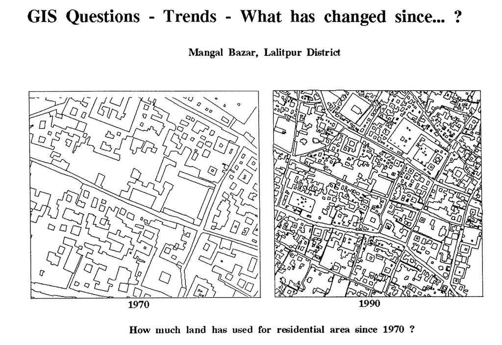
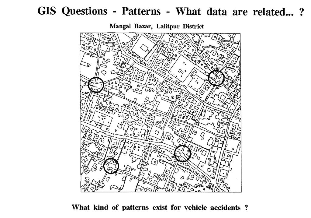
16 Trends Patterns Modelling What has changed since...? The third question might involve both of the first two and seeks to find the differences (e.g., in land use, forestation or elevation) within an area over time. What spatial pattern exists...? The distribution of landslides & Why it is mostly occurring on steep slopes (Or) Urban areas distribution, specific cropping pattern. What if...? What if.. questions are posed to determine what happens, for example, if a new road is added to a network or if a toxic substance seeps into the local groundwater supply. Answering this type of question requires both geographic and other information (as well as specific models).
17
18
19 COMPONENTS OF GIS Several components are involved in GIS technology. Hardware A computer and the associated accessories are essential for handling spatial data in GIS. These devices are collectively known as hardware like scanners, CPUs, Digitizers, Workstations & plotters etc. Software Software refers to the programmes that run on computers; these include programmes to manage the computer and to perform specific functions. For example, DBMS, Corel draw, ILWIS, Arc/view, Mapinfow, ERDAS Imagine, IDRISI and Arc/info are specialised software programmes designed to perform certain tasks. Continued
20 Database A central theme to GIS is the database. A GIS database deals with spatial data. GIS facilitate integration of spatial and attribute data and this makes GIS unique in contrast to other database systems. The beauty of GIS technology lies in the ability to assimilate divergent sources of data and analyse them. Human Input (live ware) People who work with GIS form the most important component. GIS constitute truly a interdisciplinary field and require varied backgrounds of expertise, depending upon the applications. In addition, for technical management, a Hardware Specialist, System Administrator, and Database Manager are required for corporating the GIS set-up. Policy and Procedures A methodology is must to derive the results users need. Basically, this includes spatial analysis for the particular application. By and large, this depends upon the institutional framework and its interest in exploiting GIS technology for decision-making
21 GIS Technology GIS borrows from other software technology: GIS Relational Database Management Systems Relational Database CAD Graphics Computer Assisted Design and Graphics Software Statistical Analysis and Reporting Packages Statistical Analysis
22 SPATIAL OPERATIONS Many computer programmes can handle geographic data such as those described below. Spreadsheets (e.g., EXCEL, Lotus). A spreadsheet can be thought of as a large imaginary piece of electronic paper that can contain information in rows and columns, which is used for all sorts of (mathematical) operations for producing graphs. Spreadsheets are often used in combination with GIS. Database Management Systems (e.g., Oracle, dbase, Access). A Database Management System (DBMS) is a set of programmes which is a collection of information about things and their relationships to each other and which maintain and manipulate data in a database. A DBMS only handles "attribute data" and cannot handle maps. It generally forms an integrated part of GIS. Computer Aided Design (e.g., AutoCad). CAD systems are for capturing and manipulating drawings. Point, line, and polygon objects are stored in vector format. A CAD system is like a part of a vector GIS. CAD software is highly developed and has very good display capabilities, but, on its own, it is neither designed to carry out spatial operations nor use raster data types.
23 Cartographic packages (e.g., Aldus Freehand, CarthoGraphix, ACE). Cartographic packages or desktop mapping systems are for selective search and display of information from spatial databases and for the production of high quality output maps which meet cartographic standards. In this sense, they form a useful addition to GIS, since the output facilities of most GIS are still unsatisfactory. Photogrammetrical software (e.g., DMS). Photogrammetrical packages are designed to take point sample data (mostly of terrain elevations) from aerial photographs, satellite images, and GPS (global positioning systems) data, and then produce digital elevation models (DEM) and contour maps. They form an important input source for GIS. Image Processing Software (e.g., ERDAS imagine, ILWIS). Image processing software is designed to handle satellite images, or scanned aerial photographs. The information from such images can be extracted by several kinds of image enhancement techniques and classification methods. Output maps from image processing software often form the input into GIS. These software packages are not considered to be GIS. The difference between GIS and other software using geographic data is that only GIS permit spatial operations on the data.
24 GEOGRAPHIC DATA Spatial and Non-Spatial data There are two important components of geographic database: its geographic position and its attributes or properties. In other words, spatial data (where is it?) and attribute data (what is it?) Analogue Data: A physical product displaying information visually on paper like maps, aerial photos, imageries, tabular data and written report etc. Digital Data: Information derived from computer

25 Geographic Data


26 Map: City blocks SPATIAL AND NON-SPATIAL DATA SPATIAL DATA City blocks Land use 001 Institutional 002 Commercial 003 Commercial 004 Residential 005 Residential 006 Residential 007 Industrial 008 Residential 009 Industrial 010 Industrial 011 Residential 012 Industrial 013 Residential 014 Residential 015 Residential NON-SPATIAL DATA

27 GIS - Links Data Sets GIS software links the location data and the attribute data:


28 GIS - Analysis GIS software can answer questions about our world: Attribute Questions: What provinces have more than 1.5 million people? Spatial Questions: What provinces border N-W.F.P?


29 GIS - Layers GIS contains many layers of information: These are just a few of the kinds of layers a GIS can contain: Base Map Data Elevation Surface Geology


30 GIS - Analysis GIS can analyze data in many ways:

31 Basic types of spatial Data Maps model the real world with points, lines, and polygons. Symbols and labels describe the descriptive information about the geographic features. Points Points define the discrete locations of geographic features which are too small to illustrate as lines or polygons such as well or telephone poles. Points can be used to illustrate the locations of mountain peak or discrete elevation points. Lines Lines represent the linear features of geographic object too narrow to illustrate as polygons, such as streets and streams that have length but no area. Moreover, contour lines are represented as the lines By using different symbols and labels, descriptive information of linear features are illustrated. For example: Roads are drawn with various line widths and patterns and colors to represent different road types, e.g., highway as wide solid red colour line, blue lines are used to illustrate the streams. The symbol can be used to illustrate the railway. City streets are labeled with names and often address ranges.
32 Polygons Polygons are closed features that represent the shape and location of homogeneous features such as landuse, forest types. Tone of the colour can be applied to illustrate the density of population, green color can be used to represent vegetation and blue colour can be used to illustrate lake. Surfaces A surface represents the elevation, presence or absence of something for every point on the piece of earth. The elevation models are best examples to illustrate as the surfaces. Surfaces are typically represented on the maps as the series of isolines. Elevation contours, rainfall, temperature can be represented as the surface of isolines. Surfaces can be represented as the Raster Elevation Model and Vector Elevation Model.
33 Geometry of Spatial Data Point Line Area surface
34 REPRESENTATION OF GEOGRAPHIC DATA Vector Graphics: Images are built-up from points, lines(segments) and areas (Polygons). Each defined by pair of X-Y co-ordinates. Preparing a map by digitization is converted into vector data in computer. Raster Graphics: Images are built-up from cells which is called as Pixels. In raster graphics, the smaller the area of land that each cell represents, the higher the resolution of the data and higher the spatial accuracy, ultimately the larger the files needed to store the data.
35

36 SPATIAL DATA INPUT Scanning (automatic digitizing) X Y Editing Improving Vectorizing Apply attributes Y Sensor Manual digitizing Raster model Improving Apply attributes Vector model X Digital Landscape Model
37 APPLICATION OF GIS Canada was the pioneer in development of GIS as a result of innovations dating back to the early 1960s. Much of the credit goes to Roger Tomilson for the early development of GIS. Although the field of GIS has been around for the last 25 years the real potentials have become apparent only since the late 1980s. Afterwards widely used in USA, Canada & Western Europe. Some typical examples of GIS applications are; land-use planning and management e.g. Cadestral mapping, Urban growth, Landuse changes etc. S.O.P, SUPARCO, P.D.A, C.D.A, P.E & D) oil & mineral exploration (O.G.D.C, Oil companies, P.G.S) environmental impact studies management of water resources (IIMI, AKRSP, WAPDA) natural hazard mapping (FFC, NESPAK) forestry and wildlife management (FMC, PFI, AKRSP) soil degradation studies (Soil survey of Pakistan) monitoring desertification agricultural development socio-economic survey and mapping (S.O.P & Primary education project in NWFP, Baluchistan, Sind, N.As & A.K.)

38 Environmental What are the effects of Global Warming? Land cover and temperature relationships are made clear when the data are seen at once using Geotechnology.

39 Park Management Will the new building spoil the Park Scenery? Park planners use Geotechnology to determine if a new Visitor Centre can be seen from the peak.


40 Agriculture How can I improve food production? Geotechnology is used in making crop management decisions to maximize yields and minimize fertilizer input.

41 Public Utilities Is it safe to dig here? A proposed excavation, identified by address, is compared to pipelines in the area using Geotechnology.

42 Health Care What Communities are at risk from Disease? Geotechnology identifies communities at risk of River Blindness and helps determine the impact of treatment.

43 Emergency 999 What is the fastest route to the Hospital? Geotechnology can choose the fastest route to a hospital. The GIS can take into account traffic and other impediments.

44 Real Estate Where is my Dream Home? With Geotechnology, an agent can show a map of a neighborhood and a picture or video of the actual properties.

45 Marketing How can I optimize my Marketing Campaign? Geotechnology can query a database and identify only those areas with the highest household income within a specified distance of a store.
46 THANK YOU
a system for input, storage, manipulation, and output of geographic information. GIS combines software with hardware,
 Introduction to GIS Dr. Pranjit Kr. Sarma Assistant Professor Department of Geography Mangaldi College Mobile: +91 94357 04398 What is a GIS a system for input, storage, manipulation, and output of geographic
What is GIS? ESRI Canada. August 2011
 What is GIS? ESRI Canada August 2011 Geography Matters! Environmental Park Management Agriculture Public Utilities Health Care Emergency 911 Real Estate Marketing Environmental What are the effects of
Introduction to GIS. Dr. M.S. Ganesh Prasad
 Introduction to GIS Dr. M.S. Ganesh Prasad Department of Civil Engineering The National Institute of Engineering, MYSORE ganeshprasad.nie@gmail.com 9449153758 Geographic Information System (GIS) Information
Techniques for Science Teachers: Using GIS in Science Classrooms.
 Techniques for Science Teachers: Using GIS in Science Classrooms. After ESRI, 2008 GIS A Geographic Information System A collection of computer hardware, software, and geographic data used together for
GIS = Geographic Information Systems;
 What is GIS GIS = Geographic Information Systems; What Information are we talking about? Information about anything that has a place (e.g. locations of features, address of people) on Earth s surface,
Understanding Geographic Information System GIS
 Understanding Geographic Information System GIS What do we know about GIS? G eographic I nformation Maps Data S ystem Computerized What do we know about maps? Types of Maps (Familiar Examples) Street Maps
Geography & Technology. Geography of Canada
 Geography & Technology Geography of Canada www.craigmarlatt.com/school Geography & Technology 1. Geographic Informationn Systems 2. Global Positioning System 3. Aerial Photographs 4. Satellite Imagery
Introduction-Overview. Why use a GIS? What can a GIS do? Spatial (coordinate) data model Relational (tabular) data model
 data model Relational (tabular) data model") Introduction-Overview Why use a GIS? What can a GIS do? How does a GIS work? GIS definitions Spatial (coordinate) data model Relational (tabular) data model intro_gis.ppt 1 Why use a GIS? An extension
Introduction-Overview Why use a GIS? What can a GIS do? How does a GIS work? GIS definitions Spatial (coordinate) data model Relational (tabular) data model intro_gis.ppt 1 Why use a GIS? An extension
ENV208/ENV508 Applied GIS. Week 1: What is GIS?
 ENV208/ENV508 Applied GIS Week 1: What is GIS? 1 WHAT IS GIS? A GIS integrates hardware, software, and data for capturing, managing, analyzing, and displaying all forms of geographically referenced information.
An Introduction to Geographic Information System
 An Introduction to Geographic Information System PROF. Dr. Yuji MURAYAMA Khun Kyaw Aung Hein 1 July 21,2010 GIS: A Formal Definition A system for capturing, storing, checking, Integrating, manipulating,
GIS technology. Introduction to GIS
 GIS technology Introduction to GIS 1 GIS Technology What is GIS Components of GIS Functions of GIS Benefits of GIS Real World Applications 2 What is GIS? A Geographic Information System (GIS) is a collection
Introduction to GIS I
 Introduction to GIS Introduction How to answer geographical questions such as follows: What is the population of a particular city? What are the characteristics of the soils in a particular land parcel?
NR402 GIS Applications in Natural Resources
 NR402 GIS Applications in Natural Resources Lesson 1 Introduction to GIS Eva Strand, University of Idaho Map of the Pacific Northwest from http://www.or.blm.gov/gis/ Welcome to NR402 GIS Applications in
DATA SOURCES AND INPUT IN GIS. By Prof. A. Balasubramanian Centre for Advanced Studies in Earth Science, University of Mysore, Mysore
 DATA SOURCES AND INPUT IN GIS By Prof. A. Balasubramanian Centre for Advanced Studies in Earth Science, University of Mysore, Mysore 1 1. GIS stands for 'Geographic Information System'. It is a computer-based
Advanced Algorithms for Geographic Information Systems CPSC 695
 Advanced Algorithms for Geographic Information Systems CPSC 695 Think about Geography What is Geography The 3 W s of Geography What is where Why is it there Why do I care Data - Data - Data We all got
Syllabus Reminders. Geographic Information Systems. Components of GIS. Lecture 1 Outline. Lecture 1 Introduction to Geographic Information Systems
 Syllabus Reminders Geographic Information s Lecture Introduction to Geographic Information s. Class Info: www.saigis.com/class/ 2. Office T / TH (8:00-9:30 a.m.) and (2:30 3:30pm) or Appt 3. Email: burgerpr@unk.edu
Transactions on Information and Communications Technologies vol 18, 1998 WIT Press, ISSN
 STREAM, spatial tools for river basins, environment and analysis of management options Menno Schepel Resource Analysis, Zuiderstraat 110, 2611 SJDelft, the Netherlands; e-mail: menno.schepel@resource.nl
Geographical Information System (GIS) Prof. A. K. Gosain
 Prof. A. K. Gosain") Geographical Information System (GIS) Prof. A. K. Gosain gosain@civil.iitd.ernet.in Definition of GIS GIS - Geographic Information System or a particular information system applied to geographical data
Geographical Information System (GIS) Prof. A. K. Gosain gosain@civil.iitd.ernet.in Definition of GIS GIS - Geographic Information System or a particular information system applied to geographical data
Introduction to Geographic Information Systems Dr. Arun K Saraf Department of Earth Sciences Indian Institute of Technology, Roorkee
 Introduction to Geographic Information Systems Dr. Arun K Saraf Department of Earth Sciences Indian Institute of Technology, Roorkee Lecture 01 What is Geographic Information Systems? I welcome to this
INTRODUCTION TO GEOGRAPHIC INFORMATION SYSTEM By Reshma H. Patil
 INTRODUCTION TO GEOGRAPHIC INFORMATION SYSTEM By Reshma H. Patil ABSTRACT:- The geographical information system (GIS) is Computer system for capturing, storing, querying analyzing, and displaying geospatial
Introduction to Geographic Information Systems (GIS): Environmental Science Focus
: Environmental Science Focus") Introduction to Geographic Information Systems (GIS): Environmental Science Focus September 9, 2013 We will begin at 9:10 AM. Login info: Username:!cnrguest Password: gocal_bears Instructor: Domain: CAMPUS
Introduction to Geographic Information Systems (GIS): Environmental Science Focus September 9, 2013 We will begin at 9:10 AM. Login info: Username:!cnrguest Password: gocal_bears Instructor: Domain: CAMPUS
ENVIRONMENTAL MONITORING Vol. II - Applications of Geographic Information Systems - Ondieki C.M. and Murimi S.K.
 APPLICATIONS OF GEOGRAPHIC INFORMATION SYSTEMS Ondieki C.M. and Murimi S.K. Kenyatta University, Kenya Keywords: attribute, database, geo-coding, modeling, overlay, raster, spatial analysis, vector Contents
Mapping Earth. How are Earth s surface features measured and modeled?
 Name Mapping Earth How are Earth s surface features measured and modeled? Before You Read Before you read the chapter, think about what you know about maps Record your thoughts in the first column Pair
Illustrator: Vector base Each line/point store some sort of information Mapping Representation of the world
 Illustrator: Vector base Each line/point store some sort of information Mapping Representation of the world Photoshop Raster base Images can be overlaid Pixel vector data model: [data models] A representation
What are the five components of a GIS? A typically GIS consists of five elements: - Hardware, Software, Data, People and Procedures (Work Flows)
") LECTURE 1 - INTRODUCTION TO GIS Section I - GIS versus GPS What is a geographic information system (GIS)? GIS can be defined as a computerized application that combines an interactive map with a database
LECTURE 1 - INTRODUCTION TO GIS Section I - GIS versus GPS What is a geographic information system (GIS)? GIS can be defined as a computerized application that combines an interactive map with a database
THE 3D SIMULATION INFORMATION SYSTEM FOR ASSESSING THE FLOODING LOST IN KEELUNG RIVER BASIN
 THE 3D SIMULATION INFORMATION SYSTEM FOR ASSESSING THE FLOODING LOST IN KEELUNG RIVER BASIN Kuo-Chung Wen *, Tsung-Hsing Huang ** * Associate Professor, Chinese Culture University, Taipei **Master, Chinese
CS 350 A Computing Perspective on GIS
 CS 350 A Computing Perspective on GIS What is GIS? Definitions A powerful set of tools for collecting, storing, retrieving at will, transforming and displaying spatial data from the real world (Burrough,
8/28/2011. Contents. Lecture 1: Introduction to GIS. Dr. Bo Wu Learning Outcomes. Map A Geographic Language.
 Contents Lecture 1: Introduction to GIS Dr. Bo Wu lsbowu@polyu.edu.hk Department of Land Surveying & Geo-Informatics The Hong Kong Polytechnic University 1. Learning outcomes 2. GIS definition 3. GIS examples
What is GIS? Introduction to data. Introduction to data modeling
 What is GIS? Introduction to data Introduction to data modeling 2 A GIS is similar, layering mapped information in a computer to help us view our world as a system A Geographic Information System is a
SRJC Applied Technology 54A Introduction to GIS
 SRJC Applied Technology 54A Introduction to GIS Overview Lecture of Geographic Information Systems Fall 2004 Santa Rosa Junior College Presented By: Tim Pudoff, GIS Coordinator, County of Sonoma, Information
FUNDAMENTALS OF GEOINFORMATICS PART-II (CLASS: FYBSc SEM- II)
") FUNDAMENTALS OF GEOINFORMATICS PART-II (CLASS: FYBSc SEM- II) UNIT:-I: INTRODUCTION TO GIS 1.1.Definition, Potential of GIS, Concept of Space and Time 1.2.Components of GIS, Evolution/Origin and Objectives
FUNDAMENTALS OF GEOINFORMATICS PART-II (CLASS: FYBSc SEM- II) UNIT:-I: INTRODUCTION TO GIS 1.1.Definition, Potential of GIS, Concept of Space and Time 1.2.Components of GIS, Evolution/Origin and Objectives
Overview of GIS. A typical GIS can be understood by the help of various definitions given below:-
 Overview of GIS Introduction Geographic Information System (GIS) is a computer based information system used to digitally represent and analyse the geographic features present on the Earth' surface and
1. Origins of Geography
 II. ORIGINS AND BRANCHES OF GEOGRAPHY My Notes A. Origins of Geography Unit One 6 Before carefully examining the tools of the geographer, it would be useful to examine the origins and roots of this ancient
CENSUS MAPPING WITH GIS IN NAMIBIA. BY Mrs. Ottilie Mwazi Central Bureau of Statistics Tel: October 2007
 CENSUS MAPPING WITH GIS IN NAMIBIA BY Mrs. Ottilie Mwazi Central Bureau of Statistics E-mail: omwazi@npc.gov.na Tel: + 264 61 283 4060 October 2007 Content of Presentation HISTORICAL BACKGROUND OF CENSUS
USING GIS CARTOGRAPHIC MODELING TO ANALYSIS SPATIAL DISTRIBUTION OF LANDSLIDE SENSITIVE AREAS IN YANGMINGSHAN NATIONAL PARK, TAIWAN
 CO-145 USING GIS CARTOGRAPHIC MODELING TO ANALYSIS SPATIAL DISTRIBUTION OF LANDSLIDE SENSITIVE AREAS IN YANGMINGSHAN NATIONAL PARK, TAIWAN DING Y.C. Chinese Culture University., TAIPEI, TAIWAN, PROVINCE
Systems (GIS) - with a focus on.
 - with a focus on.") Introduction to Geographic Information Systems (GIS) - with a focus on localizing the MDGs Carmelle J. Terborgh, Ph.D. ESRI www.esri.com Flying Blind Jul 24th 2003 The Economist We Live in Two Worlds Natural
Introduction to Geographic Information Systems (GIS) - with a focus on localizing the MDGs Carmelle J. Terborgh, Ph.D. ESRI www.esri.com Flying Blind Jul 24th 2003 The Economist We Live in Two Worlds Natural
GIS and Remote Sensing
 Spring School Land use and the vulnerability of socio-ecosystems to climate change: remote sensing and modelling techniques GIS and Remote Sensing Katerina Tzavella Project Researcher PhD candidate Technology
GEOGRAPHIC INFORMATION SYSTEMS
 GEOGRAPHIC INFORMATION SYSTEMS 4-H Round-Up Community Transitions Workshop Daniel Hanselka June 14, 2011 Goals of the Workshop Answer the question: What is GIS? Uses of GIS. Some of the Common Terminology
Geographic Information Systems (GIS) in Environmental Studies ENVS Winter 2003 Session III
 in Environmental Studies ENVS Winter 2003 Session III") Geographic Information Systems (GIS) in Environmental Studies ENVS 6189 3.0 Winter 2003 Session III John Sorrell York University sorrell@yorku.ca Session Purpose: To discuss the various concepts of space,
Geographic Information Systems (GIS) in Environmental Studies ENVS 6189 3.0 Winter 2003 Session III John Sorrell York University sorrell@yorku.ca Session Purpose: To discuss the various concepts of space,
PRINCIPLES OF GIS. 1 Low
 PRINCIPLES OF GIS Dhubri 1 Low Water Very High Vegetation High Vegetation Medium vegetatin vegetation Sand/bars Dhubri Dr. R N Sankhua Capture Store Computer Mapping People Analyze Display Query Software
5/15/ Use of Geographic Information System (GIS) in Grazing Management Muhammad Farooq Hussain Faisal 12-Arid-604 (M.
 in Grazing Management Muhammad Farooq Hussain Faisal 12-Arid-604 (M.") 5/15/218 1 Use of Geographic Information ystem (GI) in Grazing Management Muhammad Farooq Hussain Faisal 12-Arid-64 (M.phill LM) 1 Contents History Back Ground Information Introduction of GI Who use GI?
5/15/218 1 Use of Geographic Information ystem (GI) in Grazing Management Muhammad Farooq Hussain Faisal 12-Arid-64 (M.phill LM) 1 Contents History Back Ground Information Introduction of GI Who use GI?
A Basic Introduction to Geographic Information Systems (GIS) ~~~~~~~~~~
 ~~~~~~~~~~") A Basic Introduction to Geographic Information Systems (GIS) ~~~~~~~~~~ Rev. Ronald J. Wasowski, C.S.C. Associate Professor of Environmental Science University of Portland Portland, Oregon 3 September
A Basic Introduction to Geographic Information Systems (GIS) ~~~~~~~~~~ Rev. Ronald J. Wasowski, C.S.C. Associate Professor of Environmental Science University of Portland Portland, Oregon 3 September
THE NEW TECHNOLOGICAL ADVANCES IN CARTOGRAPHY
 Distr.: LIMITED ECA/NRD/CART. 9/ETH. 6 October 1996 Original: ENGLISH Ninth United Nations Regional Cartographic Conference for Africa Addis Ababa, Ethiopia 11-15 November 1996 THE NEW TECHNOLOGICAL ADVANCES
GIS Geographical Information Systems
 Chapter Two GIS Geographical Information Systems Chapter Two GIS Geographical Information Systems Chapter Two GIS (Geographical Information Systems) 2.1 Introduction In most cases of our day life, information
Are You Maximizing The Value Of All Your Data?
 Are You Maximizing The Value Of All Your Data? Using The SAS Bridge for ESRI With ArcGIS Business Analyst In A Retail Market Analysis SAS and ESRI: Bringing GIS Mapping and SAS Data Together Presented
Display data in a map-like format so that geographic patterns and interrelationships are visible
 Vilmaliz Rodríguez Guzmán M.S. Student, Department of Geology University of Puerto Rico at Mayagüez Remote Sensing and Geographic Information Systems (GIS) Reference: James B. Campbell. Introduction to
WHAT IS GIS? Source: Longley et al (2005) Geographic Information Systems and Science. 2nd Edition. John Wiley and Sons Ltd.
 Geographic Information Systems and Science. 2nd Edition. John Wiley and Sons Ltd.") WHAT IS GIS? Geographical Information Systems (GIS) are a special class of information systems that keep track not only of events, activities, and things, but also of where these events, activities, and
WHAT IS GIS? Geographical Information Systems (GIS) are a special class of information systems that keep track not only of events, activities, and things, but also of where these events, activities, and
Basics of GIS. by Basudeb Bhatta. Computer Aided Design Centre Department of Computer Science and Engineering Jadavpur University
 Basics of GIS by Basudeb Bhatta Computer Aided Design Centre Department of Computer Science and Engineering Jadavpur University e-governance Training Programme Conducted by National Institute of Electronics
Chapter 1. GIS Fundamentals
 1. GIS Overview Chapter 1. GIS Fundamentals GIS refers to three integrated parts. Geographic: Of the real world; the spatial realities, the geography. Information: Data and information; their meaning and
Chapter 02 Maps. Multiple Choice Questions
 Chapter 02 Maps Multiple Choice Questions 1. Every projection has some degree of distortion because A. a curved surface cannot be represented on a flat surface without distortion. B. parallels and meridians
WELCOME. To GEOG 350 / 550 Introduction to Geographic Information Science: Third Lecture
 WELCOME To GEOG 350 / 550 Introduction to Geographic Information Science: Third Lecture 1 Lecture 3: Overview Geographic Information Systems (GIS) A brief history of GIS Sources of information for GIS
Massachusetts Institute of Technology Department of Urban Studies and Planning
 Massachusetts Institute of Technology Department of Urban Studies and Planning 11.204: Planning, Communications & Digital Media Fall 2002 Lecture 6: Tools for Transforming Data to Action Lorlene Hoyt October
GIS (GEOGRAPHIC INFORMATION SYSTEMS)
") GIS (GEOGRAPHIC INFORMATION SYSTEMS) 1 1. DEFINITION SYSTEM Any organised assembly of resources and procedures united and regulated by interaction or interdependence to complete a set of specific functions.
GIS (GEOGRAPHIC INFORMATION SYSTEMS) 1 1. DEFINITION SYSTEM Any organised assembly of resources and procedures united and regulated by interaction or interdependence to complete a set of specific functions.
GIS Geographic Information System
 GIS Geographic Information System Andrea Petroselli Tuscia University, Italy petro@unitus.it SUMMARY Part 1: Part 2: Part 3: Part 4: What is a GIS? Why do we need a GIS? Which are the possibilities of
Geographical Information System GIS
 Geographical Information System GIS LOOM.02.331 anto.aasa@ut.ee Scale GIS and spatial planning National Regional Local Strategic (National Dev. Plan) National Goals and development policy Tactical (Regional
Chapter 5. GIS The Global Information System
 Chapter 5 GIS The Global Information System What is GIS? We have just discussed GPS a simple three letter acronym for a fairly sophisticated technique to locate a persons or objects position on the Earth
Introduction to GIS. Geol 4048 Geological Applications of Remote Sensing
 Introduction to GIS Geol 4048 Geological Applications of Remote Sensing GIS History: Before Computers GIS History Using maps for a long time Dr. Roger F. Tomlinson Father of GIS He was an English geographer
Geometric Algorithms in GIS
 Geometric Algorithms in GIS GIS Visualization Software Dr. M. Gavrilova GIS Software for Visualization ArcView GEO/SQL Digital Atmosphere AutoDesk Visual_Data GeoMedia GeoExpress CAVE? Visualization in
Popular Mechanics, 1954
 Introduction to GIS Popular Mechanics, 1954 1986 $2,599 1 MB of RAM 2017, $750, 128 GB memory, 2 GB of RAM Computing power has increased exponentially over the past 30 years, Allowing the existence of
Course overview. Grading and Evaluation. Final project. Where and When? Welcome to REM402 Applied Spatial Analysis in Natural Resources.
 Welcome to REM402 Applied Spatial Analysis in Natural Resources Eva Strand, University of Idaho Map of the Pacific Northwest from http://www.or.blm.gov/gis/ Where and When? Lectures Monday & Wednesday
Fundamentals of Geographic Information System PROF. DR. YUJI MURAYAMA RONALD C. ESTOQUE JUNE 28, 2010
 Fundamentals of Geographic Information System 1 PROF. DR. YUJI MURAYAMA RONALD C. ESTOQUE JUNE 28, 2010 CONTENTS OF THIS LECTURE PRESENTATION Basic concept of GIS Basic elements of GIS Types of GIS data
GEOGRAPHIC INFORMATION SYSTEM (GES203)
") GEOGRAPHIC INFORMATION SYSTEM (GES203) GIS Components Level 2:1 By: Mrs Mupfiga Presentation Layout Recap Learning Objectives Components of GIS GIS Data References Lecture Evaluation Learning Objectives
GEOGRAPHIC INFORMATION SYSTEM (GES203) GIS Components Level 2:1 By: Mrs Mupfiga Presentation Layout Recap Learning Objectives Components of GIS GIS Data References Lecture Evaluation Learning Objectives
INDUSTRIAL PARK EVALUATION BASED ON GEOGRAPHICAL INFORMATION SYSTEM TEHNOLOGY AND 3D MODELLING
 Abstract INDUSTRIAL PARK EVALUATION BASED ON GEOGRAPHICAL INFORMATION SYSTEM TEHNOLOGY AND 3D MODELLING Andreea CALUGARU University of Agronomic Sciences and Veterinary Medicine of Bucharest, Romania Corresponding
Geographic Information Systems. Introduction to Data and Data Sources
 Geographic Information Systems Introduction to Data and Data Sources Presented by John Showler, NJDA-SSCC NJ SCD GIS Training Session December 10, 209 The Objectives of this session are 3-fold: 1. Introduce
The Road to Data in Baltimore
 Creating a parcel level database from high resolution imagery By Austin Troy and Weiqi Zhou University of Vermont, Rubenstein School of Natural Resources State and local planning agencies are increasingly
INTRODUCTION TO GEOGRAPHIC INFORMATION SYSTEM
 1. Introduction INTRODUCTION TO GEOGRAPHIC INFORMATION SYSTEM Prachi Misra Sahoo I.A.S.R.I., New Delhi -110012 Geographic Information System (GIS) is a computer based information system used to digitally
Welcome to NR502 GIS Applications in Natural Resources. You can take this course for 1 or 2 credits. There is also an option for 3 credits.
 Welcome to NR502 GIS Applications in Natural Resources. You can take this course for 1 or 2 credits. There is also an option for 3 credits. The 1st credit consists of a series of readings, demonstration,
Application of high-resolution (10 m) DEM on Flood Disaster in 3D-GIS
 DEM on Flood Disaster in 3D-GIS") Risk Analysis V: Simulation and Hazard Mitigation 263 Application of high-resolution (10 m) DEM on Flood Disaster in 3D-GIS M. Mori Department of Information and Computer Science, Kinki University, Japan
Risk Analysis V: Simulation and Hazard Mitigation 263 Application of high-resolution (10 m) DEM on Flood Disaster in 3D-GIS M. Mori Department of Information and Computer Science, Kinki University, Japan
THE CADASTRAL INFORMATION SYSTEM IN THE REPUBLIC OP SOUTH AFRICA
 I $:? Distr.: LIMITED ECA/NRD/CART.9/ORG.27 November 1996 Original: ENGLISH Ninth United Nations Regional Cartographic Conference for Africa Addis Ababa, Ethiopia 11-15 November 1996 THE CADASTRAL INFORMATION
Visualization of Places Based on Network Analysis through GIS
 Dagon University Research Journal 2014, Vol. 6 Visualization of Places Based on Network Analysis through GIS Win Win Shwe * Abstract Geographic Information System is a computer-based tool for mapping and
GIS Visualization: A Library s Pursuit Towards Creative and Innovative Research
 GIS Visualization: A Library s Pursuit Towards Creative and Innovative Research Justin B. Sorensen J. Willard Marriott Library University of Utah justin.sorensen@utah.edu Abstract As emerging technologies
Wayne E. Sirmon GEO 301 World Regional Geography
 Wayne E. Sirmon GEO 301 Geography 301 Geography 301 MAP: A graphic representation of a portion of the earth s surface dawn to scale, as seen from above. Types of Maps Climate maps give general information
University of Lusaka
 University of Lusaka BSPH 315 Health Mapping & GIS Topic: Background of GIS Content: 1. Aim of the course 2. What do you know about GIS? 3. Difference between geographic data and geographic information
Geomatics: Geotechnologies in Action, Grade 12, University/College Expectations
 Geographic Foundations: Space and Systems SSV.01 explain how the earth is modelled for scientific and mapping purposes; SSV.02 demonstrate an understanding of basic spatial concepts; Page 1 SSV.03 explain
GIS FOR MAZOWSZE REGION - GENERAL OUTLINE
 GIS FOR MAZOWSZE REGION - GENERAL OUTLINE S. Bialousz 1), K Mączewski 2), E. Janczar 2), K. Osinska-Skotak 1) 1) Warsaw University of Technology, Warsaw, Poland 2) Office of the Surveyor of the Mazowieckie
PROANA A USEFUL SOFTWARE FOR TERRAIN ANALYSIS AND GEOENVIRONMENTAL APPLICATIONS STUDY CASE ON THE GEODYNAMIC EVOLUTION OF ARGOLIS PENINSULA, GREECE.
 PROANA A USEFUL SOFTWARE FOR TERRAIN ANALYSIS AND GEOENVIRONMENTAL APPLICATIONS STUDY CASE ON THE GEODYNAMIC EVOLUTION OF ARGOLIS PENINSULA, GREECE. Spyridoula Vassilopoulou * Institute of Cartography
LECTURE NOTES ON REMOTE SENSING & GIS IV B. Tech II semester (JNTU (A)-R13)
-R13)") LECTURE NOTES ON IV B. Tech II semester (JNTU (A)-R13) C.THEJASWINI VEENA Assistant Professor G.PULLAIAH COLLEGE OF ENGINEERING AND TECHNOLOGY CIVIL ENGINEERING BY C.THEJASWINI VEENA Page 1 OBJECTIVES:
LECTURE NOTES ON IV B. Tech II semester (JNTU (A)-R13) C.THEJASWINI VEENA Assistant Professor G.PULLAIAH COLLEGE OF ENGINEERING AND TECHNOLOGY CIVIL ENGINEERING BY C.THEJASWINI VEENA Page 1 OBJECTIVES:
Applications: Introduction Task 1: Introduction to ArcCatalog Task 2: Introduction to ArcMap Challenge Question References
 CHAPTER 1 INTRODUCTION 1.1 GIS? 1.1.1 Components of a GIS 1.1.2 A Brief History of GIS 1.1.3 GIS Software Products Box 1.1 A List of GIS Software Producers and Their Main Products 1.2 GIS Applications
ArcGIS for Desktop. ArcGIS for Desktop is the primary authoring tool for the ArcGIS platform.
 ArcGIS for Desktop ArcGIS for Desktop ArcGIS for Desktop is the primary authoring tool for the ArcGIS platform. Beyond showing your data as points on a map, ArcGIS for Desktop gives you the power to manage
Representing KFUPM in various forms of Services using Arc View
 King Fahd University of Petroleum and Minerals College of Environmental design City and Regional Planning department CRP-507 Computer Aided Planning Representing KFUPM in various forms of Services using
Watershed Delineation in GIS Environment Rasheed Saleem Abed Lecturer, Remote Sensing Centre, University of Mosul, Iraq
 Watershed Delineation in GIS Environment Rasheed Saleem Abed Lecturer, Remote Sensing Centre, University of Mosul, Iraq Abstract: The management and protection of watershed areas is a major issue for human
Introduction to Geographic Information Science. Updates/News. Last Lecture 1/23/2017. Geography 4103 / Spatial Data Representations
 Geography 4103 / 5103 Introduction to Geographic Information Science Spatial Data Representations Updates/News Waitlisted students First graded lab this week: skills learning Instructional labs vs. independence
Cell-based Model For GIS Generalization
 Cell-based Model For GIS Generalization Bo Li, Graeme G. Wilkinson & Souheil Khaddaj School of Computing & Information Systems Kingston University Penrhyn Road, Kingston upon Thames Surrey, KT1 2EE UK
Lecture 5. Representing Spatial Phenomena. GIS Coordinates Multiple Map Layers. Maps and GIS. Why Use Maps? Putting Maps in GIS
 Lecture 5 Putting Maps in GIS GIS responds to three fundamental questions by automating spatial data: What is where? Why is it there? GIS reveals linkages unevenly distributed social, economic and environmental
How to Pick a GIS. GIS Software Chapter 8 in Longley, Goodchild, Maguire, and Rhind,, 2001
 How to Pick a GIS GIS Software Chapter 8 in Longley, Goodchild, Maguire, and Rhind,, 2001 How to Pick a GIS Evolution of GIS software Architecture of GIS software Types of software Example products The
STEREO ANALYST FOR ERDAS IMAGINE Stereo Feature Collection for the GIS Professional
 STEREO ANALYST FOR ERDAS IMAGINE Stereo Feature Collection for the GIS Professional STEREO ANALYST FOR ERDAS IMAGINE Has Your GIS Gone Flat? Hexagon Geospatial takes three-dimensional geographic imaging
GIS and GNSS Integration
 METIS Second Master Training & Seminar GIS and GNSS Integration By Eng. Ramadan Salem M. Sc. Surveying and Geodesy Email: ramadan_salem@link.net Page 1 GIS and GNSS Integration: Plan of the Presentation
Aileen Buckley, Ph.D. and Charlie Frye
 An Information Model for Maps: Towards Production from GIS Databases Aileen Buckley, Ph.D. and Charlie Frye Researchers, ESRI GIS vs. cart GIS Outline of the presentation Introduction Differences between
Key Questions and Issues. What is GIS? GIS is to geographic analysis as: What is GIS? 9/3/2013. GEO 327G/386G, UT Austin 1
 What is GIS? Key Questions and Issues Geology Elevation Transportation Hydrography Imagery What is GIS? What are the applications of GIS? How is the real world represented in GIS? What analyses can GIS
EO Information Services. Assessing Vulnerability in the metropolitan area of Rio de Janeiro (Floods & Landslides) Project
 Project") EO Information Services in support of Assessing Vulnerability in the metropolitan area of Rio de Janeiro (Floods & Landslides) Project Ricardo Armas, Critical Software SA Haris Kontoes, ISARS NOA World
EO Information Services in support of Assessing Vulnerability in the metropolitan area of Rio de Janeiro (Floods & Landslides) Project Ricardo Armas, Critical Software SA Haris Kontoes, ISARS NOA World
Louisiana Transportation Engineering Conference. Monday, February 12, 2007
 Louisiana Transportation Engineering Conference Monday, February 12, 2007 Agenda Project Background Goal of EIS Why Use GIS? What is GIS? How used on this Project Other site selection tools I-69 Corridor
8.9 Geographical Information Systems Advantages of GIS
 8.9 Geographical Information Systems A Geographic Information System (GIS) is a computer-based system that is used in input, storage, analysis manipulation, retrieval, and output, of spatial data. These
Diffusion of GIS in Public Policy Doctoral Program
 Diffusion of GIS in Public Policy Doctoral Program By Fulbert Namwamba PhD Southern University This presentation demonstrate how GIS was introduced in the Public Policy Doctoral Program at Southern University,
GIS Supports to Economic and Social Development
 GIS Supports to Economic and Social Development Dang Van Duc and Le Quoc Hung Institute of Information Technology 18, Hoang Quoc Viet Rd., Cau Giay Dist., Hanoi, Vietnam Email: dvduc@ioit.ncst.ac.vn; lqhung@ioit.ncst.ac.vn
Introduction to GIS. Phil Guertin School of Natural Resources and the Environment GeoSpatial Technologies
 Introduction to GIS Phil Guertin School of Natural Resources and the Environment dguertin@cals.arizona.edu Mapping GeoSpatial Technologies Traditional Survey Global Positioning Systems (GPS) Remote Sensing
Yrd. Doç. Dr. Saygın ABDİKAN Öğretim Yılı Güz Dönemi
 Yabancı Dil III (YDL285) Introduction to Geomatics Yrd. Doç. Dr. Saygın ABDİKAN 2017-2018 Öğretim Yılı Güz Dönemi 1 géomatique Geo (Earth) + informatics Geodesy + Geoinformatics Geomatics: The mathematics
Abstract. Keywords: Geographic information systems and digital data model. 1. Introduction
 Abstract GISMO - A Geographical Information System for a Municipality Office Ramzi A. Haraty and Youssef O. Kaddoura Lebanese American University P.O. Box 13-5053 Chouran Beirut, Lebanon 1102 2801 Email:
ESRI* Object Models; Data Capture
 ESRI* Object Models; Data Capture * Environmental Systems Research Institute Feature Class (spatial table) Number Age_Ma 1_sigma Rx_Type Size_kg 123 124 125 142 1.5 B_schist 136 2.0 G_schist Object Class
FUNDAMENTAL GEOGRAPHICAL DATA OF THE NATIONAL LAND SURVEY FOR GIS AND OFFICIAL MAPPING. Karin Persson National Land Survey S Gavle Sweden
 ORAL PRESENTATION 467 FUNDAMENTAL GEOGRAPHICAL DATA OF THE NATIONAL LAND SURVEY FOR GIS AND OFFICIAL MAPPING Abstract Karin Persson National Land Survey S-801 82 Gavle Sweden This report presents the results
8/27/2015 M. Helper, U. Texas, Austin
 Slide 1 What is GIS? Geology Transportation Hydrography Elevation Imagery Geo327G/386G UT Austin 1 Slide 2 Key Questions and Issues What is GIS? What are the applications of GIS? How is the real world