Unit 1 The Basics of Geography. Chapter 1 The Five Themes of Geography Page 5
|
|
|
- Preston Watson
- 6 years ago
- Views:
Transcription
1 Unit 1 The Basics of Geography Chapter 1 The Five Themes of Geography Page 5
2 Geography comes from the Greek word geographia, which means to describe the earth. Geography is the study of the distribution and interaction of physical and human features on the earth.
3
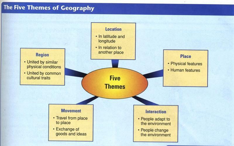
4 What are the five themes of geography? 1. Location Where is it? 2. Place What is it like? 3. Region How are places similar or different? 4. Movement How do people, goods, and ideas move from one location to another? 5. Human-Environment Interaction How do people relate to the physical world?
5 Location Geographers describe location in two ways Absolute location is the exact place on earth where a geographic feature is found. Relative location describes a place in comparison to other places around it.

6 Absolute Location Bennettsville is located at N W / N W / ;

7 The relative location of Sullivan s Island is that it is between the Isle of Palms and Charleston.
8 Location A grid system of imaginary lines are used to place something exactly on the earth s surface. Hemisphere is half of the globe or earth.

9 Northern Hemisphere of the planet Earth
10 Location The equator is the imaginary line that divides the north and south hemispheres. The prime meridian is the imaginary line diving the earth east to west. The line runs through Greenwich, England.
11 Location Latitude Lines are a set of imaginary lines that run parallel to the equator, and that are used in locating places north or south. The Equator is labeled the zero-degree line for latitude.

12 Lines of Latitude A set of imaginary lines that run parallel to the equator, and that are used in locating places north or south. The equator is labeled the zerodegree line for latitude.
13 Location Longitude lines are a set of imaginary lines that go around the earth over the poles, dividing it east and west. The prime meridian is labeled the zero-degree line for longitude.

14 Longitude Lines Longitude lines are a set of imaginary lines that go around the earth over the poles, dividing it east and west. The prime meridian is labeled the zero-degree line for longitude.
15 Place What is it like? The theme of place includes the physical features and cultural characteristics of a location. All locations on earth have features that set them apart, such as climate, landforms, and vegetation.
16 Region How are places similar or different? A region is an area of the earth s surface with similar characteristics. Geographers categorize regions in three ways: formal, functional, and perceptional regions.
17 Region A formal region is defined by a limited number of related characteristics. Examples of formal regions: The United States and Canada/Europe/ Africa/East Asia.
18 Region Functional Regions are organized around a set of interactions and connections between places. Example: a city and its suburbs

19 Region Functional Regions have a connection or connections. A city and its suburbs are a functional region. People get jobs in the cities but live in the suburbs near the cities. What connects cities and suburbs? Highways, commuter railroads, subways, and bus lines take people back and forth between a city and its suburbs.
20 Region Perceptual Regions are regions in which people perceive, or see, the characteristics of the region in the same way.

21 Region An example of perceptual region would be the Midwest of the United States. People may perceive differently where a perceptual region begins. Some people believe the Midwest begins in Ohio. Others believe the region begins in the middle of Illinois.
22 Human-Environment Interaction How do people relate to the physical world? Human-Environment Interaction takes a look at how humans relate to their environment.

23 Human-Environment Interaction How is this picture different from

24 Human-Environment Interaction this picture? Are there any similarities?
25 Human-Environment Interaction People learn to use what their environment gives them, and they learn to change that environment to meet their needs. Some people may look at a hot, sunny climate near a body of water and use it for recreational activities. Others may see a hot, sunny climate near a body of water as a great place for growing citrus, olive, or grape crops.
26 Movement How do people, goods, and ideas move from one location to another location? This question refers to movement. There are three ways to look at movement via distance: linear distance time distance psychological distance

27 Movement Linear Distance is how far across the earth a person, an idea, or a product travels. Here is a map of the Great Silk Road Trade Route. This is an example of linear distance. In this case, the product silk traveled from China to destinations of the then known world. Physical geography can affect linear distance by forcing a shift in a route to avoid impassable land or water.

28 Movement Time distance is the amount of time it takes for a person, an idea, or a product to travel. Modern inventions have shortened time distances. It is painfully apparent that a horse-drawn carriage is slower than a modern van.
29 Movement Psychological Distance is the way people view distance. Studies show that, as we become familiar with a place, we think it is closer than it actually is. Less familiar places seem to be further away. Psychological distance may influence decisions about many different human activities.


30 The Geographer s Tools Around 255 B.C., Eratosthenes drove a stake into the ground at the mouth of the Nile River in Alexandria, Egypt. Then then noted the angle of the shadow cast by the stake. Meanwhile, another person drove a stake into the ground at Syene, Egypt. This stake cast no shadow. Later, Eratosthenes calculated the circumference of the earth using the angle of the first shadow and the distance between Syene and Alexandria. He was only off about 15%, which is a remarkable accomplishment given the simple tools Eratosthenes used. Eratosthenes was one of the earliest geographers to use tools and critical thinking to measure and describe the earth. What are the tools in a geographer s toolbox?


31 The Geographer s Tools A geographer s tools include maps, globes, and data that can be displayed in a variety of ways. A map s function is to show locations of places, landforms, and bodies of water, and where they are in relation to other parts of the earth. Two or Three dimension tools Globe a three-dimensional representation of the earth. Map two-dimensional graphic representation of selected parts of the earth s surface. Advantage of a map it is easier to carry than a globe. Disadvantage of a map distortion occurs as the earth s surface is flattened to create the map.

32 The Geographer s Tools Cartographer Mapmaker A cartographer can reduce some types of distortion in maps by using different types of map projections. Map Projection a way of drawing the earth s surface that reduces distortion caused by presenting a round earth on flat paper. What are the three types of maps? General reference maps Thematic maps Navigational maps One type of general reference map is called a topographic map, which is a representation of natural and man-made features on the earth. Topographic map of Greenland

33 The Geographer s Tools Thematic maps emphasize specific kinds of information, such as climate or population density. The thematic map to the right shows the languages and minority religions of India.

34 The Geographer s Tools Navigation maps are used by sailors and pilots.

35 The Geographer s Tools The Science of Mapmaking A cartographer decides what type of map to create by considering how the map will be used. Keeping that purpose in mind, he or she then determines how much detail to show and what size the map should be. Surveying The first step in making a map is to complete a field survey. Surveyors observe, measure, and record what they see in a specific area. Remote sensing, or the gathering of geographic information from a distance by an instrument that is not physically in contact with the mapping site, is done today. These data are gathered primarily by aerial photography or by satellites. The information is recorded and converted to a grey image. Cartographers use the data and software to construct maps. Types of data: Elevation Differences in land cover Variations in temperature

 is a weather satellite. This satellite flies in orbit in sync with Earth s rotation.")
36 The Geographer s Tools Satellites are relied upon to provide geographic data. Landsat is actually a series of satellites that orbit more than 100 miles above Earth. Each time a satellite makes an orbit, it picks up data in an area 115 miles wide. Landsat can scan the entire Earth in 16 days. Geostationary Operational Environment Satellite (GOES) is a weather satellite. This satellite flies in orbit in sync with Earth s rotation. By doing so, it always views the same area. It gathers images of atmospheric conditions that are useful in forecasting the weather.

37 The Geographer s Tools The newest tool in the geographer s toolbox is Geographic Information Systems (GIS). GIS stores information about the world in a digital database. GIS has the ability to combine information from a variety of sources and display it in ways that allow the user to visualize the use of space in different ways. When using a GIS, geographers must decide upon what sort of geographic information would help them examine a problem. Next, they select the appropriate layers of information. The GIS creates a composite map combining the information.

38 The Geographer s Tools The Global Positioning System (GPS) was developed to help the military know exactly where its forces were located. GSP uses a series of 24 satellites called Navstars.
Geography involves the study of places: their locations, their characteristics, and how humans use and move around them.
 Physical Geography Looking at the Earth Geography involves the study of places: their locations, their characteristics, and how humans use and move around them. NEXT Physical Geography Looking at the Earth
UNIT 1 THE BASICS OF GEOGRAPHY
 UNIT 1 THE BASICS OF GEOGRAPHY CHAPTER 1 LOOKING AT THE EARTH 1 Section 1.1: The 5 Themes of Geography.Geography comes from a Greek word meaning writing about or describing the earth. Geography is: Geographers
Introduction to Geography
 Introduction to Geography What is geography? Geography comes from the Greek word Geographia. Geo means earth and graphia means to describe or chart. Geographers study the earth in relation to space and
STUDY GUIDE. Exploring Geography. Chapter 1, Section 1. Terms to Know DRAWING FROM EXPERIENCE ORGANIZING YOUR THOUGHTS
 For use with textbook pages 19 22. Exploring Geography Terms to Know location A specific place on the earth (page 20) absolute location The exact spot at which a place is found on the globe (page 20) hemisphere
Key Issue #1. How do geographers describe where things are? 2014 Pearson Education, Inc.
 Key Issue #1 How do geographers describe where things are? Learning Outcomes 1.1.1: Explain differences between early maps and contemporary maps. 1.1.2: Describe the role of map scale and projections and
Map Skills and Geographic Tools
 Name: Period: Map Skills and Geographic Tools TEKS: 8.9C interpret topographic maps and satellite views to identify land and erosional features and predict how these features may be reshaped by weathering
Warmup. geography compass rose culture longitude
 Warmup geography compass rose culture longitude ecosystem latitude 1. study of the special physical and human characteristics of a place or region 2. learned system of shared beliefs, traits, and values
The World of Geography Pre-Test/Study Guide Chapter 1 Test
 Read each statement or question. On the lines below write the letter of the best answer. 1. Geographers look at the Earth 5. What are the two specific A. by studying cities first. measurements of Earth
Chapter 3 Models of the Earth. 3.1 Finding Locations on the Earth. 3.1 Objectives
 Chapter 3 Models of the Earth 3.1 Finding Locations on the Earth 3.1 Objectives Explain latitude and longitude. How can latitude and longitude be used to find locations on Earth? How can a magnetic compass
Chapter 1: The World of Geography
 Chapter 1: The World of Geography Chapter 1: What is Geography? *It is the study of our earth; our home. OR *Anything that can be mapped! *Geography mixes up the physical and human aspects of our world
netw rks Guided Reading Activity Essential Question: How does geography influence the way people live? What Is Geography?
 Guided Reading Activity What Is Geography? Lesson 1 Thinking Like a Geographer Essential Question: How does geography influence the way people live? Directions: Read the lesson and use your textbook to
What Is a Globe? Hemispheres. Main Idea Globes and maps provide different ways of showing features of the earth. Terms to Know
 r Main Idea Globes and maps provide different ways of showing features of the earth. Terms to Know hemisphere latitude longitude scale bar scale relief elevation contour line What Is a Globe? A globe is
1. Write down the term 2. Write down the book definition 3. Put the definition in your own words 4. Draw an image and/or put a Real Life Example
 Unit 1 Vocabulary 1. Write down the term 2. Write down the book definition 3. Put the definition in your own words 4. Draw an image and/or put a Real Life Example Absolute Location Where Is It EXACTLY?
Mapping Earth s Surface Chapter 2 Section 3
 Mapping Earth s Surface Chapter 2 Section 3 Day 1 Objective I will understand maps can be used to find locations on Earth and to represent information about features on Earth s Surface I will understand
Texas Geography. Understanding the physical and human characteristics of our state
 Texas Geography Understanding the physical and human characteristics of our state To understand Texas you must first learn about its Geography. Geography- The study of the world, its people, and the interaction
What is Geography? Lecture 1 The Earth As A Rotating Planet. What is Geography? What is geography? Subfields of Geography?
 Lecture 1 The Earth As A Rotating Planet Geog210 Physical Geography What is Geography? Much more than place names and locations The study of spatial variation How and why things differ from place to place
Chapter 2 - Lessons 1 & 2 Studying Geography, Economics
 Chapter 2 - Lessons 1 & 2 Studying Geography, Economics How does geography influence the way people live? Why do people trade? Why do people form governments? Lesson 1 - How Does Geography Influence the
AP Human Geography Chapter 1: Thinking Geographically Key Issue 1: How do Geographers describe where things are?
 AP Human Geography Chapter 1: Thinking Geographically Key Issue 1: How do Geographers describe where things are? Studying Human Geography Physical Geography Physical geography deals with Earth s natural
THE FIVE THEMES OF GEOGRAPHY U N I T O N E
 THE FIVE THEMES OF GEOGRAPHY U N I T O N E FIVE THEMES OF GEOGRAPHY 1. Location 2. Place 3. Human-Environment Interaction 4. Movement 5. Region LOCATION LOCATION The position that something occupies Earth
Introduction to Geography
 Introduction to Geography ropic of Cancer 3½ N Arctic Circle 90 N Prime Meridian 0 Arctic Ocean Mississippi R. Appalachian Mts. Europe Rocky Mountains N. America Atlantic Gulf of Ocean Mexico Caribbean
What is Geography? *Mixes up the physical and human aspects of our world into one field of study.
 World Geography What is Geography? *It is the study of the earth *Mixes up the physical and human aspects of our world into one field of study. *Shows the relationship between people and the environment.
About places and/or important events Landmarks Maps How the land is, hills or flat or mountain range Connected to maps World Different countries
 What do you think you know about geography? About places and/or important events Landmarks Maps How the land is, hills or flat or mountain range Connected to maps World Different countries What do you
CHAPTER 1: EXPLORING GEOGRAPHY
 CHAPTER 1: EXPLORING GEOGRAPHY Please Do Now: In your PDN section of your binder answer the following with one or two sentences: What is Geography? What is Geography? The study of where people, places,
Tonight. {01} The map. Relative space. What does a map do? Types of maps GEOG 201 2/17/2010. Instructor: Pesses 1
 Tonight {01} The map What makes a map Measuring the Earth Map Interpretation & GPS Spring 2010 M. Pesses What does a map do? Shows where things are Shows spatial (topological) relationships Shows patterns,
VOCABULARY SCAVENGER HUNT Five Themes of Geography
 SECTION: VOCABULARY SCAVENGER HUNT Five Themes of Geography Directions: Skim The Five Themes of Geography and define the following words. Geography: Absolute Location: Relative Location: Hemisphere: Equator:
1. Define map: 2. Name and define the five concepts that guide geographers a) 3. Define cartography: MAPS 4. A map serves two purposes a)
 3. Define cartography: MAPS 4. A map serves two purposes a)") 1. Define map: 2. Name and define the five concepts that guide geographers c) d) e) 3. Define cartography: MAPS 4. A map serves two purposes 5. Give two examples of early mapmaking and its (unusual?) materials
1. Define map: 2. Name and define the five concepts that guide geographers c) d) e) 3. Define cartography: MAPS 4. A map serves two purposes 5. Give two examples of early mapmaking and its (unusual?) materials
Chapter 1: Basic Concepts
 Chapter 1: Basic Concepts The Cultural Landscape: An Introduction to Human Geography Defining Geography Word coined by Eratosthenes Geo = Earth Graphia = writing Geography thus means earth writing Contemporary
MR. GOFF S WORLD HISTORY UNIT ONE: GEOGRAPHY 5 THEMES OF GEOGRAPHY
 MR. GOFF S WORLD HISTORY UNIT ONE: GEOGRAPHY 5 THEMES OF GEOGRAPHY BYOD BRING YOUR OWN DEVICE IN SMALL GROUPS (3-4), USE YOUR ELECTRONIC DEVICE(S) AND DEFINE THE FOLLOWING VOCAB. WORDS 1. GEOGRAPHY 2.
Word Cards. 2 map. 1 geographic representation. a description or portrayal of the Earth or parts of the Earth. a visual representation of an area
 Name: Date: Hour: Word Cards 1 geographic representation a description or portrayal of the Earth or parts of the Earth Example: A map is a representation of an actual location or place. 2 map a visual
Test Bank Chapter 2: Representations of Earth
 Multiple Choice Test Bank Chapter 2: Representations of Earth 1. A rhumb line on a Mercator projection is a line of. a. true size b. true shape c. true compass bearing d. true location 2. Maximum longitude
Mapping Earth. How are Earth s surface features measured and modeled?
 Name Mapping Earth How are Earth s surface features measured and modeled? Before You Read Before you read the chapter, think about what you know about maps Record your thoughts in the first column Pair
Unit 1 All. Study online at quizlet.com/_3l51hr
 Unit 1 All Study online at quizlet.com/_3l51hr 1. geography: 4. 7 APHG Units+: The study of the distribution and interaction of physical and human features on the earth 2. physical geography: 1. Geography:
2 Mapping Earth Reading Essentials. 2. Contrast What is the difference between a map view and a profile view?
 Mapping Earth Maps What do you think? Read the three statements below and decide whether you agree or disagree with them. Place an A in the Before column if you agree with the statement or a D if you disagree.
CHAPTER 1: KEY ISSUE 1 How Do Geographers Describe Where Things Are? p. 4-13
 CHAPTER 1: KEY ISSUE 1 How Do Geographers Describe Where Things Are? p. 4-13 Always keep your vocabulary packet out whenever you take notes. As the term comes up in the text, add to your examples for the
Unit 1, Lesson 3 What Tools and Technologies Do Geographers Use?
 Unit 1, Lesson 3 What Tools and Technologies Do Geographers Use? Geographers use a variety of tools and technologies in investigating geographic questions. Maps and globes both represent the earth, but
What is a map? A Map is a two or three-dimensional model or representation of the Earth s surface. 2-Dimensional map
 What is a map? A Map is a two or three-dimensional model or representation of the Earth s surface. 2-Dimensional map What is a Map Projection? Planar Projection Projection A Projection is a mathematical
Chapter 1 Learning Guide Thinking Geographically
 Chapter 1 Learning Guide Thinking Geographically Key Issue 1 How Do Geographers Address Where Things Are? Pgs. 2 13 1. Define map: 2. Define cartography: Maps 3. Give an example of early mapmaking and
Location/Distance Geographers Coordinate use system these to establish location Parallels and distance:
 A Little More Stuff Remote Sensing- Acquisition of data about the earth s surface using satellites and other long range methods Global Information System (GIS)-Computer system that stores, organizes, and
1. The first globe was made by the. A) Greeks B) Romans C) Spaniards D) Egyptians
 Greeks B) Romans C) Spaniards D) Egyptians") Name Video - Maps and Globes Questions 1-11 10:45 Sequence 1. The first globe was made by the. A) Greeks B) Romans C) Spaniards D) Egyptians 2. A globe is a model of the earth that is to scale, which means
Name Video - Maps and Globes Questions 1-11 10:45 Sequence 1. The first globe was made by the. A) Greeks B) Romans C) Spaniards D) Egyptians 2. A globe is a model of the earth that is to scale, which means
CHAPTER EXIT CHAPTER. Models of Earth. 3.1 Modeling the Planet. 3.2 Mapmaking and Technology. 3.3 Topographic Maps CHAPTER OUTLINE
 EXIT CHAPTER.1 Modeling the Planet.2 Mapmaking and Technology. Topographic Maps CHAPTER OUTLINE CHAPTER.1 Modeling the Planet A flat of Earth is a convenient tool, but it can distort the shape, distance,
Unit 1 Part 2. Concepts Underlying The Geographic Perspective
 Unit 1 Part 2 Concepts Underlying The Geographic Perspective Unit Expectations 1.B Enduring Understanding: Students will be able to.. Know that Geography offers asset of concepts, skills, and tools that
SOCIAL STUDIES GRADE 6. I Can Checklist REGIONS AND PEOPLE OF THE EASTERN HEMISPHERE. Office of Teaching and Learning Curriculum Division
 SOCIAL STUDIES REGIONS AND PEOPLE OF THE EASTERN HEMISPHERE GRADE 6 I Can Checklist 2018-2019 Aligned with Ohio s Learning Standards for Social Studies Office of Teaching and Learning Curriculum Division
Different types of maps and how to read them.
 Different types of maps and how to read them. A map is a picture or representation of the Earth's surface, showing how things are related to each other by distance, direction, and size. Maps have been
A Correlation of. Eastern Hemisphere. Ohio s Learning Standards Social Studies: K-12 Grade 6
 A Correlation of Eastern Hemisphere To Grade 6 to,, Grade 6 Introduction This document demonstrates how, Eastern Hemisphere, Ohio Edition, meets : K-12 Social Studies for Grade 6. Correlation page references
Chapter 02 Maps. Multiple Choice Questions
 Chapter 02 Maps Multiple Choice Questions 1. Every projection has some degree of distortion because A. a curved surface cannot be represented on a flat surface without distortion. B. parallels and meridians
Chapter 2: Studying Geography, Economics, and Citizenship
 Chapter 2: Studying Geography, Economics, and Citizenship Lesson 2.1 Studying Geography I. Displaying the Earth s Surface A. A globe of the Earth best shows the sizes of continents and the shapes of landmasses
Exploring Geography. Chapter 1
 Exploring Geography Chapter 1 The Study of Geography Geography is the study of where people, places, and things are located and how they relate to each other. Greek meaning writing about or describing
Unit 1, Lesson 2. What is geographic inquiry?
 What is geographic inquiry? Unit 1, Lesson 2 Understanding the way in which social scientists investigate problems will help you conduct your own investigations about problems or issues facing your community
Name Class Date. For each pair of terms, explain how the meanings of the terms differ.
 Skills Worksheet Chapter Review USING KEY TERMS For each pair of terms, explain how the meanings of the terms differ. 1. true north and magnetic north 2. latitude and longitude 3. equator and prime meridian
Warm up: (8 min) Use the Map, On the Prom (Color) Paper (Blk/White) and answer the questions on your paper
 Use the Map, On the Prom (Color) Paper (Blk/White) and answer the questions on your paper") Warm up: (8 min) Use the Map, On the Prom (Color) Paper (Blk/White) and answer the questions on your paper TX History: Mapping and Geography of Texas: We will discuss some slides and write notes on others
Warm up: (8 min) Use the Map, On the Prom (Color) Paper (Blk/White) and answer the questions on your paper TX History: Mapping and Geography of Texas: We will discuss some slides and write notes on others
Foundational Themes in Teaching and Learning Geography
 LESSON OBJECTIVES 1. Discuss how each of the basic geographic skills is applied in geographic study. 2. Locate appropriately places in maps by applying the concepts of absolute and relative location. 3.
Nursery. Reception. Year 1
 Nursery Geography Overview Autumn Spring Summer Notices detailed features of objects in their environment. Comments and asks questions about aspects of their familiar world such as the place where they
Unit 1 Chapter 1. Thinking Geographically * Basics of Geography
 Global Cultures Unit 1 Chapter 1 Thinking Geographically * Basics of Geography 1.1 Geography in Greek means writing about the Earth study the Earth Geography Geographer asks: WHERE things are found on
3. Give two examples of early mapmaking and its (unusual?) materials for the maps. (a)
 materials for the maps. (a)") Thinking Geographically: Key Issue 1 How Do Geographers Describe Where Things Are? Rubenstein Ch. 1 pp. 4 12 1. Define map: 2. Define cartography: MAPS 3. Give two examples of early mapmaking and its (unusual?)
Thinking Geographically: Key Issue 1 How Do Geographers Describe Where Things Are? Rubenstein Ch. 1 pp. 4 12 1. Define map: 2. Define cartography: MAPS 3. Give two examples of early mapmaking and its (unusual?)
Wayne E. Sirmon GEO 301 World Regional Geography
 Wayne E. Sirmon GEO 301 Geography 301 Geography 301 MAP: A graphic representation of a portion of the earth s surface dawn to scale, as seen from above. Types of Maps Climate maps give general information
Name: Date: Period: #: Chapter 1: Outline Notes What Does a Historian Do?
 Name: Date: Period: #: Chapter 1: Outline Notes What Does a Historian Do? Lesson 1.1 What is History? I. Why Study History? A. History is the study of the of the past. History considers both the way things
The Earth is a Rotating Sphere
 The Earth is a Rotating Sphere The Shape of the Earth Earth s Rotation ( and relative movement of the Sun and Moon) The Geographic Grid Map Projections Global Time The Earth s Revolution around the Sun
Mapping Our World Chapter 2
 Mapping Our World Chapter 2 Section 2.1: Latitude and Longitude Maps are flat models of threedimensional objects. For thousands of years people have used maps to define borders and to find places. With
6. Provide an example of developments in geography for each of the following:
 Thinking Geographically: Key Issue 1 How Do Geographers Describe Where Things Are? Rubenstein, p. 5-13 1. Define map: 2. Define cartography: MAPS 3. Give two examples of developments in early mapmaking.
5 Themes of Geography Review Video Notes What is Geography?
 Name PG # 5 Themes of Geography Review Video Notes What is Geography? The study of, their, and their Main Idea or Topic Continents Notes about Main Idea or Topic There are 7 Continents or in the world:
How Geographers View the World: Human Geography. ESSENTIAL QUESTION: How does geography influence the way people live?
 How Geographers View the World: Human Geography ESSENTIAL QUESTION: How does geography influence the way people live? Geographers Think Spatially Gefffffdgfhfjgjp Guiding Question: What does it mean to
Advanced World Geography Chapter 01 Exploring Geography
 Advanced World Geography Chapter 01 Exploring Geography Lesson 1 Study of Geography In this lesson you will learn how to: tell what geography is and what geographic tools are used. tell what the various
Chapter One. Thinking Geographically
 Chapter One Thinking Geographically Where are you? Tell me where you are. How do you know? Important Terms Map two dimensional or flat scale model of the Earth. Place A specific Point on the Earth s surface.
Map Skills Test. 1. What do we call a person who makes maps? a. mapographer b. cartographer c. geologist d. archaeologist
 Map Skills Test 1. What do we call a person who makes maps? a. mapographer b. cartographer c. geologist d. archaeologist 2. What is the name of the 0 latitude line? a. Equator b. Arctic Circle c. First
Some of these parallels are very important. In the Northern Hemisphere, there is the Tropic of Cancer and the Arctic Circle.
 PDF 2 Geographic coordinates 1 The geographic coordinates system is network of imaginary horizontal and vertical lines that are drawn on globes or maps. These lines are called parallels (lines of latitude)
Physical Geography: Looking at the Earth
 CHAPTER PLANNING GUIDE Physical Geography: Looking at the Earth OVERVIEW INSTRUCTIONAL RESOURCES ESSENTIAL QUESTION What concepts and tools do geographers use to study the world? Focus on the Essential
A. Spatial Sense (Working with Maps, Globes, and Other Geographic Tools)
") A. Spatial Sense (Working with Maps, Globes, and Other Geographic Tools) Measuring Distance Using Map Scale All maps are drawn to scale; that is, they are smaller than the things they represent. Scale
A. Spatial Sense (Working with Maps, Globes, and Other Geographic Tools) Measuring Distance Using Map Scale All maps are drawn to scale; that is, they are smaller than the things they represent. Scale
Chapters 1-3 Test Review
 Chapters 1-3 Test Review Pre-AP World Geography 1. A Mercator projection is a common example of what type of projection? 2. A Robinson projection looks similar to what type of projection, except its east-west
Geography 101: The Basics
 Geography 101: The Basics What is Geography? Geography is the study of the HUMAN and NON- HUMAN features of the Earth.! Geographers study where things are located why they are located in a specific place.!
EARTH SCIENCE KEY UNIT 2-H
 EARTH SCIENCE KEY UNIT 2-H UNIT 2 MODELS & DIMENSIONS OF EARTH I. Model = ANYTHING THAT REPRESENTS THE PROPERTIES OF AN OBJECT OR SYSTEM A. Types and examples of models: 1. PHYSICAL Provides us with information
Key Issue #1 - Why is Geography a Science?
 AP Human Geography - 1 Rubenstein s The Cultural Landscape Chapter 1: Thinking Geographically Introduction to Note Packets Reading the textbook and taking notes while reading are NECESSARY steps in processing
Geography Mile Post 1
 Mile Post 1 Use world maps, atlases and globes to identify the UK and its countries, as well as the countries, continents and oceans studied at this key stage Key Skills IPC learning Goals 1.11 Be able
Geography Can Be Cool. Seriously
 Geography Can Be Cool Seriously Why does geography matter? Geography: the study of looking at every aspect of the Earth s systems, such as human economies, societies, cultures, plants, animals, & climate.
Map Skills Unit. Note taking unit
 Map Skills Unit Note taking unit Introduction To learn about the Earth, we are going to learn about two geographic tools you can use.globes and maps. Globe A globe is a round model of the planet Earth
THE EARTH AND ITS REPRESENTATION
 UNIT 7 THE EARTH AND ITS REPRESENTATION TABLE OF CONTENTS 1 THE EARTH AND THE SOLAR SYSTEM... 2 2 THE EARTH S MOVEMENTS... 2 2.1 Rotation.... 2 2.2 The revolution of the Earth: seasons of the year....
Complete the following: a. Lines of latitude are parallel to the equator. Name:
 Name: Date: Social Studies Introduction: Basic Geography Period: Latitude Latitude is defined as a measurement of distance in degrees north and south of the equator. The word latitude is derived from the
Chapter 1, Section 1 Exploring Geography
 Chapter 1, Section 1 Exploring Geography (Pages 19 22) Setting a Purpose for Reading Think about these questions as you read: What are the physical and human features geographers study? How do geographers
Introduction to Cartography Part I
 Introduction to Cartography Part I Introduction to Cartography Maps vs. Globes General Types of Maps Standard Map Features Maps versus Globes Map: a representation of the world, or part of it, in two dimensions
Five Themes of Geography. EG.5.J.a - Use and evaluate geographic research sources to interpret Earth's physical and human systems.
 Five Themes of Geography EG.5.J.a - Use and evaluate geographic research sources to interpret Earth's physical and human systems. What is Geography? Geography is the study of the earth and of the ways
4th Grade US Regional Geography First Nine Weeks
 4th Grade US Regional Geography First Nine Weeks 2014-2015 Identify the choice that best completes the statement or answers the question. 1 The line identified as 0 runs west and east on the globe and
Geographical knowledge and understanding scope and sequence: Foundation to Year 10
 Geographical knowledge and understanding scope and sequence: Foundation to Year 10 Foundation Year 1 Year 2 Year 3 Year 4 Year 5 Year 6 Year level focus People live in places Places have distinctive features
Five Themes of Geography. By PresenterMed
 Five Themes of Geography By PresenterMed Geography Geography: the study of the Earth Where are things located? Why are they there? Location Location: where a place is Cardinal Directions: North, South,
Aerial Photograhy. Brief history of aerial photography
 MAPWORK TOPIC ONE Why do we use maps? Maps are very important tools for geographers because they enable them to record, display and analyse information about people and the environment around them. Maps
SOCIAL STUDIES GRADE 5. I Can Checklist Office of Teaching and Learning Curriculum Division REGIONS AND PEOPLE OF THE WESTERN HEMISPHERE
 SOCIAL STUDIES REGIONS AND PEOPLE OF THE WESTERN HEMISPHERE GRADE 5 I Can Checklist 2015-2016 Aligned with Ohio s Learning Standards for Social Studies Office of Teaching and Learning Curriculum Division
Witchampton CofE First School Geography Curriculum Map
 2016-2017 Autumn People and : 30-50 Show interest in the lives of people who are familiar to them. Shows interest in different occupations. Remembers and talks significant events in their own experience.
Chapter 1 Introduction to the Earth
 Chapter 1 Introduction to the Earth What is Geography? The study of the earth as the home of humankind. Greek - Eratosthenes Father of Geography Geo means Earth Graphy means to write Study how things are
History of Cartography,
 Maps History of Cartography, the art and science of making maps ~2300 BC ~600 BC Early oldest known maps: Babylonian clay tablets. Greek and Roman Ptolemy s (about AD 85-165) "world map" depicted the Old
Map Master Skills Handbook
 1 Map Master Skills Handbook Five Themes of Geography Understanding Globes How To Use A Map Human Migration Notebook Number Mr. Graver Old World Cultures Name Period 2 In this chapter, you ll be introduced
2. What does the map scale tell the map reader? a ratio between the actual distance on the ground and the length given to that distance on a map
 AP Human Geography - Damon Name Unit 1 - Intro to Human Geography Hour Map and Globe Skills Review Note: All links in this packet are found on our Wikispace under Map and Globe Skills Review First, read
Understanding Projections
 GEOGRAPHY SKILLS 1 Understanding Projections The earth is a sphere and is best shown as a globe. For books and posters, though, the earth has to be represented as a flat object. To do this, mapmakers create
Key Issue 1: How Do Geographers Describe Where Things Are?
 Key Issue 1: How Do Geographers Describe Where Things Are? Pages 5-13 and some information from pages 15-18. ***Always keep your key term packet out whenever you take notes from Rubenstein. As the terms
Mapping Earth. Technology and Mapmaking
 CHAPTER 1 LESSON 2 Mapping Earth Technology and Mapmaking Key Concepts What can a topographic map tell you about the shape of Earth s surface? What can you learn from geologic maps about the rocks near
GRADE 6 GEOGRAPHY TERM 1 LATITUDE AND LONGITUDE (degrees)
") 1 GRADE 6 GEOGRAPHY TERM 1 LATITUDE AND LONGITUDE (degrees) Contents Lines of Latitude... 2 Lines of Longitude... 3 The hemispheres of The Earth... 4 Finding countries and cities on a map using latitude
1 GRADE 6 GEOGRAPHY TERM 1 LATITUDE AND LONGITUDE (degrees) Contents Lines of Latitude... 2 Lines of Longitude... 3 The hemispheres of The Earth... 4 Finding countries and cities on a map using latitude
Using Maps. Using Maps. Using Maps. Using Maps
 A is a visual representation, or model, of part or all of the earth. lines are imaginary lines that run east to west around the globe; they are also known as parallels. They show distances in degrees north
MR. JOHNSON S. Geography OHIO COUNTY MIDDLE SCHOOL
 MR. JOHNSON S Geography OHIO COUNTY MIDDLE SCHOOL CHAPTER 1 Geography The science of geography is likely the oldest of all sciences. Geography is the answer to the question that the earliest humans asked,
Globes, Maps, and Atlases. Plus, A Whole Bunch of Other Way Cool Geographic Information!!!
 Globes, Maps, and Atlases Plus, A Whole Bunch of Other Way Cool Geographic Information!!! Globes Are the Most Accurate Portrayal of the Earth The earth is about 24,900 miles in circumference, and about
THE GRID SYSTEM. System of imaginary lines that give the exact position of a place on Earth
 WORLD GEOGRAPHY THE GRID SYSTEM System of imaginary lines that give the exact position of a place on Earth LATITUDE Imaginary lines that travel horizontally around the earth measuring North and South Latitude
Developing Spatial Awareness :-
 Developing Spatial Awareness :- We begin to exercise our geographic skill by examining he types of objects and features we encounter. Four different spatial objects in the real world: Point, Line, Areas
AP Human Geography. Basic Concepts
 AP Human Geography Basic Concepts An in-depth Social Science Many people have misconceptions about geography and think of the discipline as simply an exercise in memorizing place names. Where we find Geography?
Chapter 1: Basic Concepts
 Chapter 1: Basic Concepts The Cultural Landscape: An Introduction to Human Geography Defining Geography Word coined by Eratosthenes Geo = Earth Graphia = writing Geography thus means earth writing Contemporary