GIS Basics GIS lab
|
|
|
- Valerie Osborne
- 5 years ago
- Views:
Transcription
1
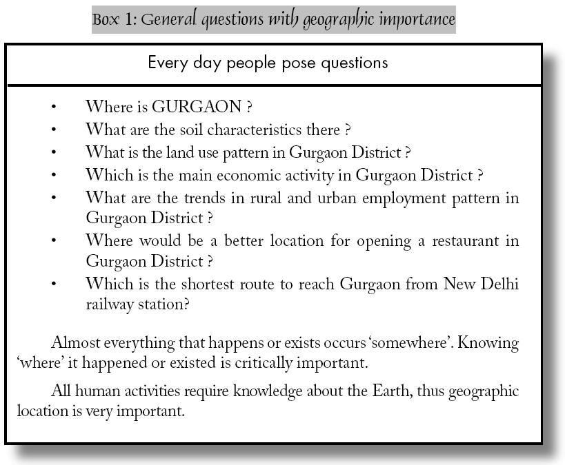
2 Geographic importance Almost everything that happens or exists occurs somewhere. Knowing where it happened or existed is critically important. All human activities require knowledge about the Earth, thus geographic location is very important. Spatial Information Technology is the outcome of developments in computer technology. Internet and computerization has opened a vast new potential in the way we perceive, communicate and analyze our surrounding spatial phenomena. Data representing the real world can be stored, processed and presented in relatively simplified forms to suit specific needs. This provides base for geographical information system
. Geographical information, then, is essential for effective planning and decision making.")
3 Geographical information allows us to apply general principles to the specific conditions of each location, allows us to track what is happening at any place, and helps us to understand how one place differs from another (Figure 1.1). Geographical information, then, is essential for effective planning and decision making
4 - 4 -
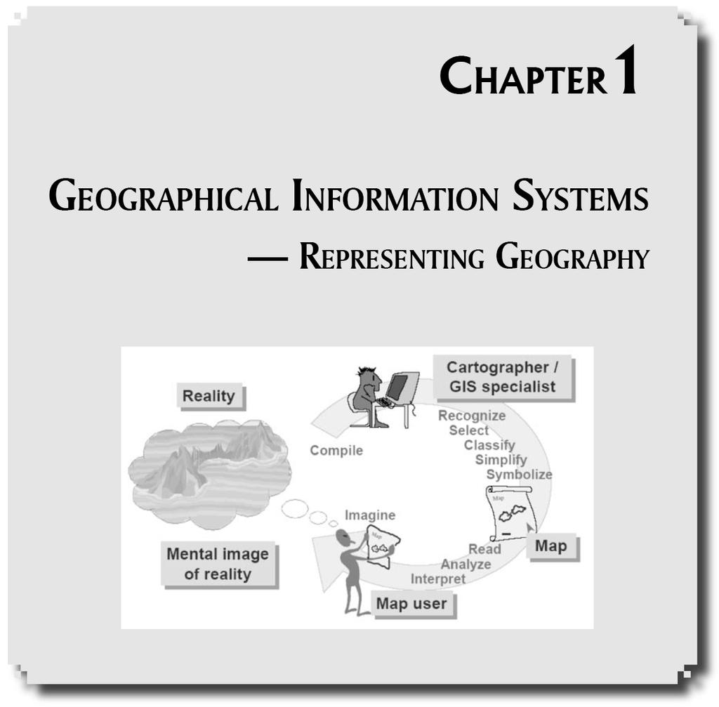
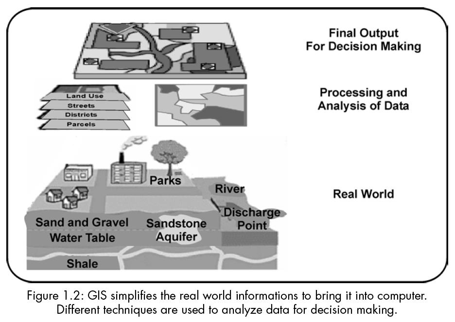
5 If we can express the contents of a map or image in digital form, the power of the computer opens an enormous range of possibilities for communication, analysis, modelling, and accurate decision making (Figure 1.2). We must constantly be aware of the fact that the digital representation of geography is not equal to the geography itselfany digital representation involves some degree of approximation
6 - 6 -
7 INFORMATION TECHNOLOGIES IN GEOGRAPHY Discipline-Specific Tools 1. Cartography and Computer: Assisted Drafting: Computers offer the same advantages to cartographers that word-processing software offers writers. Automated techniques are now the rule rather than the exception in cartographic production. 2. Photogrammetry and Remote Sensing: Aerial photogrammetry, a well established technique for cartographic production and geographic analysis, is now complemented by the use of remotely sensed information gathered by satellites in outer space. Information technologies have made both sorts of information far more readily available and far easier to use
8 3. Spatial Statistics: Statistical analysis and modelling of spatial patterns and processes have long relied on computer technology. Advances in information technology have made these techniques more widely accessible and have allowed models to expand in complexity and scale to provide more accurate depictions of real-world processes. 4. Geographic Information Systems (GIS): These systems allow geographers to collate and analyze information far more readily than is possible with traditional research techniques. GIS can be viewed as an integrating technology insofar as it draws upon and extends techniques that geographers have long used to analyze natural and social systems
9 General Communication, Research, and Publication Technologies 1. Communication and Collaboration: Electronic mail, discussion lists, and computer bulletin boards make it far easier for colleagues to communicate ideas and share ideas, locally, nationally, and internationally. Distance learning techniques make it possible to hold interactive classes and workshops simultaneously at distant locations. 2. Access to Library and Research Materials and Sources: Network access to both primary and secondary research resources is expanding rapidly. From their offices, scholars can now get information held by libraries, government agencies, and research institutions all over the world
10 3. Publication and Dissemination: Information technologies are reducing substantially the cost of publishing and distributing information as well as reducing the time required to circulate the latest news and research results
11 THE COURSE OF TECHNOLOGICAL INNOVATION Four phases of the technological innovation 1. Initiation: An innovation first becomes available. 2. Contagion: Far-ranging experimentation follows to see how the innovation can be adapted to meet a wide variety of research and commercial needs. Some, but not necessarily all of these experiments will work. 3. Coordination: The most promising applications of the innovation gradually gain acceptance and are developed collaboratively. The coordination of experimentation helps to distribute the potentially high costs of further development and implementation. 4. Integration: An innovation is accepted and integrated into routine research tasks
12 Four phases of Innovations in geography 1. Initiation: Late 1950s, 1960s and early 1970s. Methods of sophisticated mathematical and statistical modelling were developed and the first remote sensing data became available. 2. Contagion: The mid-1970s to early 1990s. The first commercially available software for GIS became available in the late 1970s and spurred many experiments. 3. Coordination: Early 1990s, or perhaps just a bit earlier. The strengths and weaknesses of many information technologies were by then apparent, and researchers began to work together to cultivate the most promising applications on a large scale
13 4. Integration: Arguably, the complete integration of information technologies in geography has yet to be achieved except perhaps in a few relatively specialized research areas. Complete integration across the discipline may, in fact, be many years away
14 GIS as an Integrating Technology In the context of the innovations, geographic information systems have served an important role as an integrating technology. Rather than being completely new, GIS have evolved by linking a number of discrete technologies into a whole that is greater than the sum of its parts. With GIS it is possible to map, model, query, and analyze large quantities of data all held together within a single database. The development of GIS has relied on innovations made in many different disciplines: Geography, Cartography, Photogrammetry, Remote Sensing, Surveying, Geodesy, Civil Engineering, Statistics, Computer Science, Operations Research, Artificial Intelligence, Demography, and many other branches of the social sciences, natural sciences, and engineering have all contributed
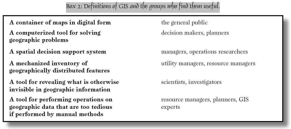
15 GEOGRAPHIC INFORMATION SYSTEMS: A GENERIC DEFINITION GIS is a special-purpose digital database in which a common spatial coordinate system is the primary means of reference. Comprehensive GIS require a means of: 1. Data input, from maps, aerial photos, satellites, surveys, and other sources. 2. Data storage, retrieval, and query. 3. Data transformation, analysis, and modelling, including spatial statistics. 4. Data reporting, such as maps, reports, and plans. THREE OBSERVATIONS SHOULD BE MADE ABOUT THIS DEFINITION First, GIS are related to other database applications, but with an important difference. GIS database uses geo-references as the primary means of storing and accessing information

16 Second, GIS integrates technology. Third, GIS, with its array of functions, should be viewed as a process rather than as merely software or hardware. GIS are for making decisions
17 What Actually GIS is? GIS can be defined as A system for Capturing, storing, checking, integrating, manipulating, analysing and displaying data which are spatially referenced to the Earth. This is normally considered to involve a spatially referenced computer database and appropriate applications software. Geographic Information System (GIS) can also be defined as: The organized activity by which people Measure aspects of geographic phenomena and processes; Represent these measurements, usually in the form of a computer database, to emphasize spatial themes, entities, and relationships; Operate upon these representations to produce more measurements and to discover new relationships by integrating disparate sources; and
 in which these people carry out")
18 Transform these representations to conform to other frameworks of entities and relationships. These activities reflect the larger context (institutions and cultures) in which these people carry out their work
19 Other definitions A definition quoted in William Huxhold s Introduction to Urban Geographic Information Systems:... The purpose of a traditional GIS is first and foremost spatial analysis. Therefore, capabilities may have limited data capture and cartographic output. Capabilities of analyses typically support decision making for specific projects and / or limited geographic areas. The map data-base characteristics (accuracy, continuity, completeness, etc.) are typically appropriate for small-scale map output. Vector and raster data interfaces may be available. However, topology is usually the sole underlying data structure for spatial analyses
20 C. Dana Tomlin s definition, from Geographic Information Systems and Cartographic Modelling: A geographic information system is a facility for preparing, presenting, and interpreting facts that pertain to the surface of the earth. This is a broad definition... a considerably narrower definition, however, is more often employed. In common parlance, a geographic information system or GIS is a configuration of computer hardware and software specifically designed for the acquisition, maintenance, and use of cartographic data
21 From Jeffrey Star and John Estes, in Geographic Information Systems: An Introduction: A geographic information system (GIS) is an information system that is designed to work with data referenced by spatial or geographic coordinates. In other words, a GIS is both a database system with specific capabilities for spatially-reference data, as well [as] a set of operations for working with data... In a sense, a GIS may be thought of as a higher-order map. In the range of definitions presented, different emphases are placed on various aspects of GIS. Some miss the true power of GIS, its ability to integrate information and to help in making decisions. But all include the essential features of spatial references and data analysis

22 THE GIS VIEW OF THE WORLD GIS provide powerful tools for addressing geographical and environmental issues. In the case below, a set of maps that will be helpful for urban transportation planning have been gathered
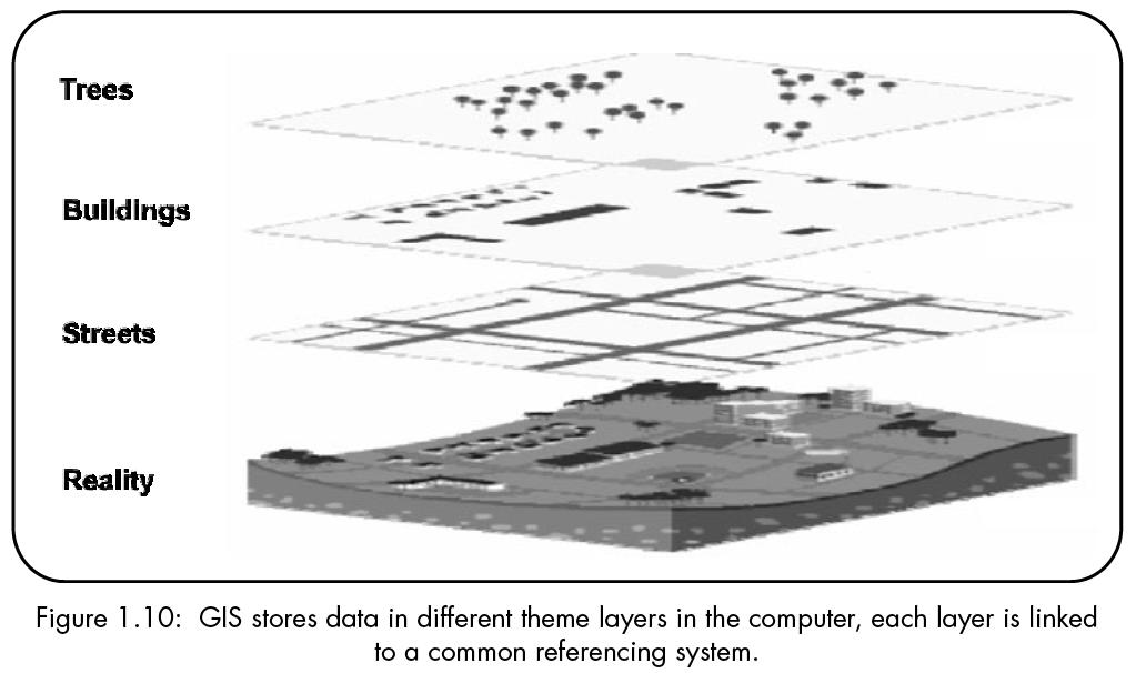
23 Each of these separate thematic maps is referred to as a layer, coverage, or level. Each layer has been carefully overlaid on the others so that every location is precisely matched to its corresponding locations on all the other maps. The bottom layer of this diagram is the most important, for it represents the grid of a locational reference system (such as latitude and longitude) to which all the maps have been precisely registered
24 WHY IS GIS IMPORTANT? GIS technology is to geographical analysis what the microscope, the telescope, and computers have been to other sciences... (It) could therefore be the catalyst needed to dissolve the regionalsystematic and human-physical dichotomies that have long plagued geography and other disciplines which use spatial information. GIS integrates spatial and other kinds of information within a single system it offers a consistent framework for analyzing geographical data. By putting maps and other kinds of spatial information into digital form, GIS allows us to manipulate and display geographical knowledge in new and exciting ways
25 GIS makes connections between activities based on geographic proximity looking at data geographically can often suggest new insights, explanations. these connections are often unrecognized without GIS, but can be vital to understanding and managing activities and resources. e.g. we can link toxic waste records with school locations through geographic proximity. GIS allows access to administrative records property ownership, tax files, utility cables and pipes via their geographical positions. Maps are fascinating and so are maps in computers and there is increasing interest in geography and geographic education in recent times. GIS gives a high tech feel to geographic information
26 - 26 -
27 CONTRIBUTING DISCIPLINES Geography: Geography is broadly concerned with understanding the world and man s place in it. The discipline of geography provides techniques for conducting spatial analysis and a spatial perspective on research. Cartography: Cartography is concerned with the display of spatial information. Cartography provides long tradition in the design of maps which is an important form of output from GIS. Computer cartography (also called digital cartography, automated cartography ) provides methods for digital representation and manipulation of cartographic features and methods of visualization. Remote Sensing: This emerging technique which records images from space and the air are major source of geographical data. The main advantage of it is that interpreted data from a remote sensing system can be merged with other data layers in a GIS
28 Photogrammetry: Using aerial photographs and techniques for making accurate measurements from them, photogrammetry is the source of most data on topography (ground surface elevations) used for input to GIS. Surveying: Surveying is concerned with the measurement of locations of objects on the Earth s surface, particularly property boundaries. Surveying provides high quality data on positions of land boundaries, buildings, etc. Statistics: Many models built using GIS are statistical in nature, many statistical techniques used for analysis in GIS. Statistics is important in understanding issues of error and uncertainty in GIS data
29 Computer Science: Computer science is one of the main engines for GIS development. Artificial intelligence (AI) uses the computer to make choices based on available data in a way that is seen to emulate human intelligence and decision-making. Computer aided design (CAD) provides software, techniques for data input, display and visualization, representation, particularly in 3 dimensions. Advances in computer graphics provide hardware, software for handling and displaying graphic objects, techniques of visualization. Database management systems (DBMS) contribute methods for representing data in digital form, procedures for system design and handling large volumes of data, particularly access and update. Mathematics: Several branches of mathematics, especially geometry and graph theory, are used in GIS system design and analysis of spatial data
30 MAJOR AREAS OF APPLICATION Classification of GIS applications Functional classification: One way to classify GIS applications is by functional characteristics of the systems; this includes a consideration of characteristics of data themes, functionality and product. A classification based on these characteristics quickly becomes fuzzy since GIS is a flexible tool whose great strength is the ability to integrate data themes, functionality and output. GIS as a decision support tool: Another way to classify GIS is by the kinds of decisions that are supported by the GIS. Decisions range from major to minor. Decision support is a good basis for definition of GIS, but not for differentiating between applications since individual GIS systems are generally used to make several different kinds of decisions
31 GIS users: a. mature technologies which interact with GIS, sharing its technology and creating data for it such as surveyors and engineers, cartographers, scientists using remote sensing techniques. b. management and decision-making groups such as resource inventors, and resource managers, urban planners, municipal officials managing land records for taxation and ownership control, facilities managers, managers involved in marketing and retail planning or vehicle routing and scheduling. c. science and research activities at universities and government labs these groups of GIS activity seeking to find distinctions and similarities between them
32 Some important areas where GIS is being used are: Different Streams of Planning: Urban planning, housing, transportation planning architectural conservation, urban design, landscape planning etc. Street Network Based Application: It is an addressed matched application, vehicle routing and scheduling: location, development and site selection and disaster planning. Natural Resource Based Application: Management and environmental impact analysis of wild and scenic recreational resources, flood plain, wetlands, acquifers, forests, and wildlife. View Shed Analysis: Hazardous or toxic factories siting and ground water modelling. Wildlife habitat study and migrational route planning
33 Land Parcel Based: Zoning, sub-division plans review, land acquisition, environment impact analysis, nature quality management and maintenance etc. Facilities Management: Can locate underground pipes and cables for maintenance, planning, tracking energy use
34 THE APPEAL AND POTENTIAL OF GIS The great appeal of GIS stems from their ability to integrate great quantities of information about the environment and to provide a powerful repertoire of analytical tools to explore this data. The ability to separate information in layers, and then combine it with other layers of information is the reason why GIS hold such great potential as research and decision-making tools
35 - 35 -
36 Development of GIS Since the mid s, specialized computer systems have been developed to process geographical information in various ways. Techniques to input geographical information, converting the information to digital form. Techniques for storing such information in compact format on computer disks, compact disks (CDs), and other digital storage media. Methods for automated analysis of geographical data, to search for patterns, combine different kinds of data, make measurements, find optimum sites or routes, and a host of other tasks. Methods to predict the outcome of various scenarios, such as the effects of climate change on vegetation. Techniques for display of data in the form of maps, images, and other kinds of displays. Capabilities for output of results in the form of numbers and tables
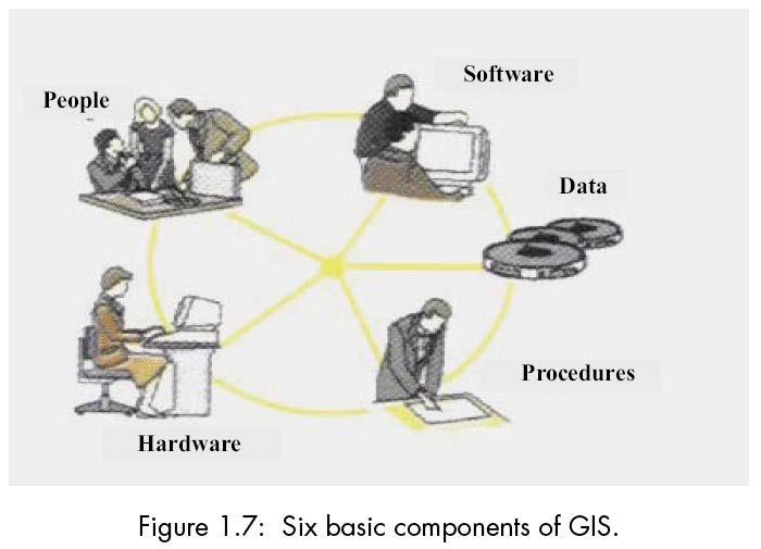
37 COMPONENTS OF GIS Hardware: It consists of the computer system on which the GIS software will run. These computer systems should have essentially an efficient processor to run the software and sufficient memory to store enough information (data). Software: GIS software provides the functions and tools needed to store, analyze, and display geographic information. All GIS software generally fit all these requirements, but their on screen appearance (user interface) may be different
38 Data: Geographic data and related tabular data are the backbone of GIS. The digital map forms the basic data input for GIS. A GIS will integrate spatial data with other data resources and can even use a DBMS. Method: A successful GIS operates according to a well-designed plan, which are the models and operating practices unique to each task. There are various techniques used for map creation and further usage for any project
39 People: GIS users range from technical specialists who design and maintain the system to those who use it to help them perform their everyday work. They plan, implement and operate to draw conclusions for decision making. Network: With rapid development of IT, today the most fundamental of these is probably the network, without which no rapid communication or sharing of digital information could occur. GIS today relies heavily on the Internet, acquiring and sharing large geographic data sets
40 - 40 -
41 These six components of a GIS are interlinked. Although it is very easy to purchase the constituent parts of a GIS (the computer hardware and basic software), the system functions only when the requisite expertise is available, the data are compiled, the necessary routines are organized, and the programs are modified to suit the application
42 The hardware and software functions of a GIS include: Compilation Storage Updating and changing Management and exchange Manipulation Retrieval and presentation Acquisition and verification Analysis and combination
43 All of these actions and operations are applied by a GIS to the geographical data that form its database
44 Geographical information attaches a variety of qualities and characteristics to geographical locations (Figure 1.10). These qualities may be physical parameters such as ground elevation, soil moisture level, or classifications according to the type of vegetation, ownership of land, zoning, and so on. Such occurrences as accidents, floods, or landslides may also be included. We use the general term attributes to refer to the qualities or characteristics of places. Attributes are one of the two basic elements of geographical information, along with locations
45 - 45 -
46 The ability of a GIS to store relationships between features in addition to feature locations and attributes is one of the most important sources of the power and flexibility of this technology
47 Data integration is one of the most valuable functions of a GIS
48 Technically, a GIS organizes and exploits digital geographical data stored in databases
49 Databases are vital in all geographical information systems. They ensure that data are: Stored and maintained in one place Stored in a uniform, structured, and controlled manner than can be documented Accessible to many users at once, each of whom has the same understanding of the database s contents Easily updated with new data
50 This contrasts with the traditional way of organizing and storing data on paper in filing cabinets, in which data are often: Stored in ways that are understandable to one person only Easily corrupted by use, or edited in ways that are meaningful only to the editor Inaccessible to anyone other than the creator of the system Stored in formats and at scales that are so diverse that they cannot be compared or collated Difficult to update
51 GIS Diversity Although the general definition of GIS given here is quite valid, in practice the diversity of GIS has spawned various definitions. First, users have contrived working definitions suited to their own specific uses. Second, those with a more theoretical approach may use definitions that are different from those used in practical applications
52 There are many views of GISs, including: A data processing system designed for map production or visualization A data analysis system for examining conflicts over plans or optimizing the design of transport systems An information system for responding to queries about land ownership or soil type A management system to support the operations of a utility company, helping it to maintain its distribution network of pipes or cables A planning system to aid the design of road systems, excavations, or forest harvest operations An electronic navigation system for use in land or sea transport
53 GISs are often designated according to application. land information systems (LISs) urban information systems (UISs) natural resource information systems (NRISs) automatic mapping/facility management (AM/FM) The software capabilities required for a GIS often overlap those needed by other computer applications, particularly image processing and computer-assisted design (CAD). Today, the distinction between image processing and GIS is becoming increasingly blurred as images become more and more important sources of GIS data. The distinction between CAD and GIS has become increasingly blurred in recent years; by adding appropriate features, many former vendors of CAD systems are now able to compete effectively in the GIS market
54 BENEFITS OF COMPUTERIZING INFORMATION GIS offers its users the ability to process quantities of data far beyond the capacities of manual systems. Data in GIS are stored in a uniform, structured manner, as opposed to manual systems in which data are stored in archives and files, in agencies, on file cards, on maps, or in long reports. Data may be retrieved from GIS databases and manipulated far more rapidly and reliably than data in manual systems. In addition, data are quickly compiled into documents using techniques that include automatic mapmaking and direct report printouts. The potential gains from switching from manually prepared maps and ordinary files to computerized GIS are considerable, in both the public and private sectors
55 Benefits are often related to objectives and that the following benefit/cost ratios may be attained by introducing GIS (Figure 1.14): 1. If computerized GIS is used for automated production and maintenance of maps, the benefit/cost ratio is 1:1. 2. If the system is also used for other internal tasks such as work manipulation and planning, the benefit/cost ratio may be 2:1. 3. The full benefit of the system is first realized when information is shared among various users. The benefit/cost ratio may then be 4:1. Nonetheless, it is obvious that investment in GIS is at least as productive as investment in other sectors
56 - 56 -
57 Measurable benefits Improved efficiency due to more work being performed by the same staff, or the same work performed by a smaller staff Reduction in direct operating costs through better bases for financial management, less costly maintenance of facilities, and joint uses of available data Increases in income due to increased sales, or sales of new products and services
58 Intangible benefits Improved public and private decision making in administration, planning, and operations Improved information and service to the public Increased safety, and reduction in the impact of disasters through better planned evacuation and more efficient management of emergency services An improved environment for future generations Better presentation of plans and their associated effects Improved decisions regarding new development, and better analysis of market and site conditions
59 Users of GIS Users of GIS naturally fall into two groups: professional operators of GIS and management and decision-making groups. Professional operators of GIS They spend much of their lives working with the technology in their jobs. They are well trained in the particular software they use and are well aware of its capabilities. In many cases they do not use the results of their work themselves, but pass them to end users. Management and decision-making groups They may maintain a GIS capability on their personal workstation in order to produce an occasional map, to find a park in an unfamiliar city, to plan a driving route for a vacation, or to carry out analysis of map data in connection with a research project
60 The GIS must be simple and easy to use. This second group also comprises end users and primary users who make professional decisions based on GIS products. The group includes: Operation and maintenance engineers; a typical decision may be whether to replace or repair a damaged water main. Regional planners; characteristic tasks involve presentations of plans to municipal authorities in a realistic, varied, visual manner. Building authority functionaries; representative jobs include processing building permit applications involving access roads, water supply, or sewage. Revenue officials, typically dealing with tax assessment and taxpayer addresses. Road engineers, whose responsibilities include locating new roads to minimize cut-and-fill operations
61 Information officers; information produced may include complete packages to newly established firms with details on industrial areas, schools, and transportation. Local officials, who may require updated overviews on the effects of effluents on water quality at municipal hand pumps. Fire brigades, for whom rapid, reliable information on the locations of fires and the presence of hazards such as explosives would be invaluable. Forest managers planning harvest operations, computing volumes of annual growths, estimating road costs and identifying sensitive wildlife areas
Geographical Information System (GIS) Prof. A. K. Gosain
 Prof. A. K. Gosain") Geographical Information System (GIS) Prof. A. K. Gosain gosain@civil.iitd.ernet.in Definition of GIS GIS - Geographic Information System or a particular information system applied to geographical data
Geographical Information System (GIS) Prof. A. K. Gosain gosain@civil.iitd.ernet.in Definition of GIS GIS - Geographic Information System or a particular information system applied to geographical data
Syllabus Reminders. Geographic Information Systems. Components of GIS. Lecture 1 Outline. Lecture 1 Introduction to Geographic Information Systems
 Syllabus Reminders Geographic Information s Lecture Introduction to Geographic Information s. Class Info: www.saigis.com/class/ 2. Office T / TH (8:00-9:30 a.m.) and (2:30 3:30pm) or Appt 3. Email: burgerpr@unk.edu
GIS = Geographic Information Systems;
 What is GIS GIS = Geographic Information Systems; What Information are we talking about? Information about anything that has a place (e.g. locations of features, address of people) on Earth s surface,
a system for input, storage, manipulation, and output of geographic information. GIS combines software with hardware,
 Introduction to GIS Dr. Pranjit Kr. Sarma Assistant Professor Department of Geography Mangaldi College Mobile: +91 94357 04398 What is a GIS a system for input, storage, manipulation, and output of geographic
Introduction to GIS. Dr. M.S. Ganesh Prasad
 Introduction to GIS Dr. M.S. Ganesh Prasad Department of Civil Engineering The National Institute of Engineering, MYSORE ganeshprasad.nie@gmail.com 9449153758 Geographic Information System (GIS) Information
DATA SOURCES AND INPUT IN GIS. By Prof. A. Balasubramanian Centre for Advanced Studies in Earth Science, University of Mysore, Mysore
 DATA SOURCES AND INPUT IN GIS By Prof. A. Balasubramanian Centre for Advanced Studies in Earth Science, University of Mysore, Mysore 1 1. GIS stands for 'Geographic Information System'. It is a computer-based
Understanding Geographic Information System GIS
 Understanding Geographic Information System GIS What do we know about GIS? G eographic I nformation Maps Data S ystem Computerized What do we know about maps? Types of Maps (Familiar Examples) Street Maps
FUNDAMENTALS OF GEOINFORMATICS PART-II (CLASS: FYBSc SEM- II)
") FUNDAMENTALS OF GEOINFORMATICS PART-II (CLASS: FYBSc SEM- II) UNIT:-I: INTRODUCTION TO GIS 1.1.Definition, Potential of GIS, Concept of Space and Time 1.2.Components of GIS, Evolution/Origin and Objectives
FUNDAMENTALS OF GEOINFORMATICS PART-II (CLASS: FYBSc SEM- II) UNIT:-I: INTRODUCTION TO GIS 1.1.Definition, Potential of GIS, Concept of Space and Time 1.2.Components of GIS, Evolution/Origin and Objectives
Learning Computer-Assisted Map Analysis
 Learning Computer-Assisted Map Analysis by Joseph K. Berry* Old-fashioned math and statistics can go a long way toward helping us understand GIS Note: This paper was first published as part of a three-part
Welcome to GST 101: Introduction to Geospatial Technology. This course will introduce you to Geographic Information Systems (GIS), cartography,
, cartography,") Welcome to GST 101: Introduction to Geospatial Technology. This course will introduce you to Geographic Information Systems (GIS), cartography, remote sensing, and spatial analysis through a series of
Welcome to GST 101: Introduction to Geospatial Technology. This course will introduce you to Geographic Information Systems (GIS), cartography, remote sensing, and spatial analysis through a series of
An Introduction to Geographic Information System
 An Introduction to Geographic Information System PROF. Dr. Yuji MURAYAMA Khun Kyaw Aung Hein 1 July 21,2010 GIS: A Formal Definition A system for capturing, storing, checking, Integrating, manipulating,
Technical Drafting, Geographic Information Systems and Computer- Based Cartography
 Technical Drafting, Geographic Information Systems and Computer- Based Cartography Project-Specific and Regional Resource Mapping Services Geographic Information Systems - Spatial Analysis Terrestrial
STATE GEOGRAPHIC INFORMATION DATABASE
 STATE GEOGRAPHIC INFORMATION DATABASE Data Information and Knowledge Management STATE GEOGRAPHIC INFORMATION DATABASE EXECUTIVE SUMMARY Utah has developed one of the most comprehensive statewide GIS resources
INTRODUCTION TO GEOGRAPHIC INFORMATION SYSTEM By Reshma H. Patil
 INTRODUCTION TO GEOGRAPHIC INFORMATION SYSTEM By Reshma H. Patil ABSTRACT:- The geographical information system (GIS) is Computer system for capturing, storing, querying analyzing, and displaying geospatial
Introduction-Overview. Why use a GIS? What can a GIS do? Spatial (coordinate) data model Relational (tabular) data model
 data model Relational (tabular) data model") Introduction-Overview Why use a GIS? What can a GIS do? How does a GIS work? GIS definitions Spatial (coordinate) data model Relational (tabular) data model intro_gis.ppt 1 Why use a GIS? An extension
Introduction-Overview Why use a GIS? What can a GIS do? How does a GIS work? GIS definitions Spatial (coordinate) data model Relational (tabular) data model intro_gis.ppt 1 Why use a GIS? An extension
ENV208/ENV508 Applied GIS. Week 1: What is GIS?
 ENV208/ENV508 Applied GIS Week 1: What is GIS? 1 WHAT IS GIS? A GIS integrates hardware, software, and data for capturing, managing, analyzing, and displaying all forms of geographically referenced information.
GIS Geographical Information Systems. GIS Management
 GIS Geographical Information Systems GIS Management Difficulties on establishing a GIS Funding GIS Determining Project Standards Data Gathering Map Development Recruiting GIS Professionals Educating Staff
GIS (GEOGRAPHIC INFORMATION SYSTEMS)
") GIS (GEOGRAPHIC INFORMATION SYSTEMS) 1 1. DEFINITION SYSTEM Any organised assembly of resources and procedures united and regulated by interaction or interdependence to complete a set of specific functions.
GIS (GEOGRAPHIC INFORMATION SYSTEMS) 1 1. DEFINITION SYSTEM Any organised assembly of resources and procedures united and regulated by interaction or interdependence to complete a set of specific functions.
5/15/ Use of Geographic Information System (GIS) in Grazing Management Muhammad Farooq Hussain Faisal 12-Arid-604 (M.
 in Grazing Management Muhammad Farooq Hussain Faisal 12-Arid-604 (M.") 5/15/218 1 Use of Geographic Information ystem (GI) in Grazing Management Muhammad Farooq Hussain Faisal 12-Arid-64 (M.phill LM) 1 Contents History Back Ground Information Introduction of GI Who use GI?
5/15/218 1 Use of Geographic Information ystem (GI) in Grazing Management Muhammad Farooq Hussain Faisal 12-Arid-64 (M.phill LM) 1 Contents History Back Ground Information Introduction of GI Who use GI?
FIRE DEPARMENT SANTA CLARA COUNTY
 DEFINITION FIRE DEPARMENT SANTA CLARA COUNTY GEOGRAPHIC INFORMATION SYSTEM (GIS) ANALYST Under the direction of the Information Technology Officer, the GIS Analyst provides geo-spatial strategic planning,
GEOGRAPHIC INFORMATION SYSTEMS Session 8
 GEOGRAPHIC INFORMATION SYSTEMS Session 8 Introduction Geography underpins all activities associated with a census Census geography is essential to plan and manage fieldwork as well as to report results
Oregon Department of Transportation. Geographic Information Systems Strategic Plan
 Oregon Department of Transportation Geographic Information Systems Strategic Plan Adopted May, 2000 By the GIS Steering Committee Last printed 10/2/2012 4:20:00 PM Page Geographic Information Systems Strategic
GIS Geographical Information Systems
 Chapter Two GIS Geographical Information Systems Chapter Two GIS Geographical Information Systems Chapter Two GIS (Geographical Information Systems) 2.1 Introduction In most cases of our day life, information
1.1 What is Site Fingerprinting?
 Site Fingerprinting Utilizing GIS/GPS Technology 1.1 What is Site Fingerprinting? Site fingerprinting is a planning tool used to design communities where protection of natural resources is the primary
Techniques for Science Teachers: Using GIS in Science Classrooms.
 Techniques for Science Teachers: Using GIS in Science Classrooms. After ESRI, 2008 GIS A Geographic Information System A collection of computer hardware, software, and geographic data used together for
Canadian Board of Examiners for Professional Surveyors Core Syllabus Item C 5: GEOSPATIAL INFORMATION SYSTEMS
 Study Guide: Canadian Board of Examiners for Professional Surveyors Core Syllabus Item C 5: GEOSPATIAL INFORMATION SYSTEMS This guide presents some study questions with specific referral to the essential
Introduction to Geographic Information Systems Dr. Arun K Saraf Department of Earth Sciences Indian Institute of Technology, Roorkee
 Introduction to Geographic Information Systems Dr. Arun K Saraf Department of Earth Sciences Indian Institute of Technology, Roorkee Lecture 01 What is Geographic Information Systems? I welcome to this
Chapter : 1 : Introduction of GIS
 History of GIS : Chapter : 1 : Introduction of GIS In 1960 the Department of Forestry and Rural Department of Canada has decided to pursue a large-scale project to manage the resources. The initial task
Cell-based Model For GIS Generalization
 Cell-based Model For GIS Generalization Bo Li, Graeme G. Wilkinson & Souheil Khaddaj School of Computing & Information Systems Kingston University Penrhyn Road, Kingston upon Thames Surrey, KT1 2EE UK
Introduction to GIS I
 Introduction to GIS Introduction How to answer geographical questions such as follows: What is the population of a particular city? What are the characteristics of the soils in a particular land parcel?
Diffusion of GIS in Public Policy Doctoral Program
 Diffusion of GIS in Public Policy Doctoral Program By Fulbert Namwamba PhD Southern University This presentation demonstrate how GIS was introduced in the Public Policy Doctoral Program at Southern University,
Exploring the boundaries of your built and natural world. Geomatics
 Exploring the boundaries of your built and natural world Geomatics Before the Luxor brought magic to the Las Vegas strip and before the South LRT extension in Edmonton gave residents a new route to travel,
Introduction to Geographic Information Systems
 Introduction to Geographic Information Systems What is GIS? GIScience, Geography and Cartography GIS Maps Why is it important? What is Driving GIS? Applications of GIS Case Studies Components of a GIS
USING GIS IN WATER SUPPLY AND SEWER MODELLING AND MANAGEMENT
 USING GIS IN WATER SUPPLY AND SEWER MODELLING AND MANAGEMENT HENRIETTE TAMAŠAUSKAS*, L.C. LARSEN, O. MARK DHI Water and Environment, Agern Allé 5 2970 Hørsholm, Denmark *Corresponding author, e-mail: htt@dhigroup.com
GIS Needs Assessment. for. The City of East Lansing
 GIS Needs Assessment for The City of East Lansing Prepared by: Jessica Moy and Richard Groop Center for Remote Sensing and GIS, Michigan State University February 24, 2000 Executive Summary At the request
geographic patterns and processes are captured and represented using computer technologies
 Proposed Certificate in Geographic Information Science Department of Geographical and Sustainability Sciences Submitted: November 9, 2016 Geographic information systems (GIS) capture the complex spatial
GIS FOR MAZOWSZE REGION - GENERAL OUTLINE
 GIS FOR MAZOWSZE REGION - GENERAL OUTLINE S. Bialousz 1), K Mączewski 2), E. Janczar 2), K. Osinska-Skotak 1) 1) Warsaw University of Technology, Warsaw, Poland 2) Office of the Surveyor of the Mazowieckie
GEOMATICS. Shaping our world. A company of
 GEOMATICS Shaping our world A company of OUR EXPERTISE Geomatics Geomatics plays a mayor role in hydropower, land and water resources, urban development, transport & mobility, renewable energy, and infrastructure
UTAH S STATEWIDE GEOGRAPHIC INFORMATION DATABASE
 UTAH S STATEWIDE GEOGRAPHIC INFORMATION DATABASE Data Information and Knowledge Management NASCIO Awards 2009 STATE GEOGRAPHIC INFORMATION DATABASE B. EXECUTIVE SUMMARY Utah has developed one of the most
NR402 GIS Applications in Natural Resources
 NR402 GIS Applications in Natural Resources Lesson 1 Introduction to GIS Eva Strand, University of Idaho Map of the Pacific Northwest from http://www.or.blm.gov/gis/ Welcome to NR402 GIS Applications in
GEOGRAPHIC INFORMATION SYSTEMS SPECIALIST 3 DEFINITION:
 Hunterdon County Department of Planning and Land Use Vacancy: Geographic Information Systems Specialist 3 Full Time: 40 Hours per Week Compensation: $42,000.00 per year GEOGRAPHIC INFORMATION SYSTEMS SPECIALIST
CARTOGRAPHIC INFORMATION MANAGEMENT IN COLOMBIA REACH A LEVEL OF PERFECTION
 CARTOGRAPHIC INFORMATION MANAGEMENT IN COLOMBIA REACH A LEVEL OF PERFECTION Jaime Alberto Duarte Castro 1 Carrera 30 No. 48 51 Bogotá - Colombia, jduarte@igac.gov.co Claudia Inés Sepúlveda Fajardo 2 Carrera
Geospatial natural disaster management
 Geospatial natural disaster management disasters happen. are you ready? Natural disasters can strike almost anywhere at any time, with no regard to a municipality s financial resources. These extraordinarily
STEREO ANALYST FOR ERDAS IMAGINE Stereo Feature Collection for the GIS Professional
 STEREO ANALYST FOR ERDAS IMAGINE Stereo Feature Collection for the GIS Professional STEREO ANALYST FOR ERDAS IMAGINE Has Your GIS Gone Flat? Hexagon Geospatial takes three-dimensional geographic imaging
Land Administration and Cadastre
 Geomatics play a major role in hydropower, land and water resources and other infrastructure projects. Lahmeyer International s (LI) worldwide projects require a wide range of approaches to the integration
Introduction to Geographic Information Systems
 Introduction to Geographic Information Systems Geography 176A Fall 2013 The sequence Geog 176A - Introduction to Geographic Information Systems, 4.0, Clarke Introduction to modern spatial data processing,
USING GIS CARTOGRAPHIC MODELING TO ANALYSIS SPATIAL DISTRIBUTION OF LANDSLIDE SENSITIVE AREAS IN YANGMINGSHAN NATIONAL PARK, TAIWAN
 CO-145 USING GIS CARTOGRAPHIC MODELING TO ANALYSIS SPATIAL DISTRIBUTION OF LANDSLIDE SENSITIVE AREAS IN YANGMINGSHAN NATIONAL PARK, TAIWAN DING Y.C. Chinese Culture University., TAIPEI, TAIWAN, PROVINCE
ArcGIS for Desktop. ArcGIS for Desktop is the primary authoring tool for the ArcGIS platform.
 ArcGIS for Desktop ArcGIS for Desktop ArcGIS for Desktop is the primary authoring tool for the ArcGIS platform. Beyond showing your data as points on a map, ArcGIS for Desktop gives you the power to manage
Systems (GIS) - with a focus on.
 - with a focus on.") Introduction to Geographic Information Systems (GIS) - with a focus on localizing the MDGs Carmelle J. Terborgh, Ph.D. ESRI www.esri.com Flying Blind Jul 24th 2003 The Economist We Live in Two Worlds Natural
Introduction to Geographic Information Systems (GIS) - with a focus on localizing the MDGs Carmelle J. Terborgh, Ph.D. ESRI www.esri.com Flying Blind Jul 24th 2003 The Economist We Live in Two Worlds Natural
Government GIS and its Application for Decision Support
 Government GIS and its Application for Decision Support Zhang Qingpu (Chinese Academy of Surveying and Mapping, Email: zhangqp@casm.ac.cn) Abstract: Application of GIS in government agencies is called
APPLICATION OF GIS IN ELECTRICAL DISTRIBUTION NETWORK SYSTEM
 See discussions, stats, and author profiles for this publication at: https://www.researchgate.net/publication/305263658 APPLICATION OF GIS IN ELECTRICAL DISTRIBUTION NETWORK SYSTEM Article October 2015
GIS-based Smart Campus System using 3D Modeling
 GIS-based Smart Campus System using 3D Modeling Smita Sengupta GISE Advance Research Lab. IIT Bombay, Powai Mumbai 400 076, India smitas@cse.iitb.ac.in Concept of Smart Campus System Overview of IITB Campus
GIS TECHNICIAN I GIS TECHNICIAN II
 GIS TECHNICIAN I GIS TECHNICIAN II CITY OF ROSEVILLE DEFINITION To perform a variety of technical office and field work duties related to the creation and maintenance of maps, tables, graphs and other
Compact guides GISCO. Geographic information system of the Commission
 Compact guides GISCO Geographic information system of the Commission What is GISCO? GISCO, the Geographic Information System of the COmmission, is a permanent service of Eurostat that fulfils the requirements
Massachusetts Institute of Technology Department of Urban Studies and Planning
 Massachusetts Institute of Technology Department of Urban Studies and Planning 11.204: Planning, Communications & Digital Media Fall 2002 Lecture 6: Tools for Transforming Data to Action Lorlene Hoyt October
8/28/2011. Contents. Lecture 1: Introduction to GIS. Dr. Bo Wu Learning Outcomes. Map A Geographic Language.
 Contents Lecture 1: Introduction to GIS Dr. Bo Wu lsbowu@polyu.edu.hk Department of Land Surveying & Geo-Informatics The Hong Kong Polytechnic University 1. Learning outcomes 2. GIS definition 3. GIS examples
Visualization of Places Based on Network Analysis through GIS
 Dagon University Research Journal 2014, Vol. 6 Visualization of Places Based on Network Analysis through GIS Win Win Shwe * Abstract Geographic Information System is a computer-based tool for mapping and
GIS Visualization: A Library s Pursuit Towards Creative and Innovative Research
 GIS Visualization: A Library s Pursuit Towards Creative and Innovative Research Justin B. Sorensen J. Willard Marriott Library University of Utah justin.sorensen@utah.edu Abstract As emerging technologies
Overview of GIS. A typical GIS can be understood by the help of various definitions given below:-
 Overview of GIS Introduction Geographic Information System (GIS) is a computer based information system used to digitally represent and analyse the geographic features present on the Earth' surface and
Oakland County Parks and Recreation GIS Implementation Plan
 Oakland County Parks and Recreation GIS Implementation Plan TABLE OF CONTENTS 1.0 Introduction... 3 1.1 What is GIS? 1.2 Purpose 1.3 Background 2.0 Software... 4 2.1 ArcGIS Desktop 2.2 ArcGIS Explorer
The Road to Data in Baltimore
 Creating a parcel level database from high resolution imagery By Austin Troy and Weiqi Zhou University of Vermont, Rubenstein School of Natural Resources State and local planning agencies are increasingly
What is GIS? Introduction to data. Introduction to data modeling
 What is GIS? Introduction to data Introduction to data modeling 2 A GIS is similar, layering mapped information in a computer to help us view our world as a system A Geographic Information System is a
Green Space Services for Local Monitoring
 Green Space Services for Local Monitoring Aratos Group V3.0 2016/08 Value added services for the society using space and satellite technologies Aratos Group 2 One of the first European downstream value
IMPLEMENTAION OF GIS TECHNOLOGY IN THE NILE AND ITS WADIS ABSTRACT
 IMPLEMENTAION OF GIS TECHNOLOGY IN THE NILE AND ITS WADIS Eng. NADIA M. ABD EI- SALAM 1 Dr. ABDEL AZIZ TAREK M. 2 ABSTRACT Traditional methods have been used for several years for map production of the
Understanding China Census Data with GIS By Shuming Bao and Susan Haynie China Data Center, University of Michigan
 Understanding China Census Data with GIS By Shuming Bao and Susan Haynie China Data Center, University of Michigan The Census data for China provides comprehensive demographic and business information
Chapter 10: The Future of GIS Why Speculate? 10.2 Future Data 10.3 Future Hardware 10.4 Future Software 10.5 Some Future Issues and Problems
 Chapter 10: The Future of GIS 10.1 Why Speculate? 10.2 Future Data 10.3 Future Hardware 10.4 Future Software 10.5 Some Future Issues and Problems Theme of the Course GIS's place in understanding geographic
Geographical knowledge and understanding scope and sequence: Foundation to Year 10
 Geographical knowledge and understanding scope and sequence: Foundation to Year 10 Foundation Year 1 Year 2 Year 3 Year 4 Year 5 Year 6 Year level focus People live in places Places have distinctive features
Advanced Algorithms for Geographic Information Systems CPSC 695
 Advanced Algorithms for Geographic Information Systems CPSC 695 Think about Geography What is Geography The 3 W s of Geography What is where Why is it there Why do I care Data - Data - Data We all got
Geographic Information Systems (GIS) in Environmental Studies ENVS Winter 2003 Session III
 in Environmental Studies ENVS Winter 2003 Session III") Geographic Information Systems (GIS) in Environmental Studies ENVS 6189 3.0 Winter 2003 Session III John Sorrell York University sorrell@yorku.ca Session Purpose: To discuss the various concepts of space,
Geographic Information Systems (GIS) in Environmental Studies ENVS 6189 3.0 Winter 2003 Session III John Sorrell York University sorrell@yorku.ca Session Purpose: To discuss the various concepts of space,
Are You Maximizing The Value Of All Your Data?
 Are You Maximizing The Value Of All Your Data? Using The SAS Bridge for ESRI With ArcGIS Business Analyst In A Retail Market Analysis SAS and ESRI: Bringing GIS Mapping and SAS Data Together Presented
INTRODUCTION TO GEOGRAPHIC INFORMATION SYSTEM
 1. Introduction INTRODUCTION TO GEOGRAPHIC INFORMATION SYSTEM Prachi Misra Sahoo I.A.S.R.I., New Delhi -110012 Geographic Information System (GIS) is a computer based information system used to digitally
FUTURE DATA. Future data Future hardware Future software Future issues. Getting Started With GIS. Chapter 10
 THE FUTURE OF GIS Getting Started With GIS Chapter 10 GIS Futures Future data Future hardware Future software Future issues Dursun Z. ªeker Theme of the book GIS's place in understanding geographic distributions
THE 3D SIMULATION INFORMATION SYSTEM FOR ASSESSING THE FLOODING LOST IN KEELUNG RIVER BASIN
 THE 3D SIMULATION INFORMATION SYSTEM FOR ASSESSING THE FLOODING LOST IN KEELUNG RIVER BASIN Kuo-Chung Wen *, Tsung-Hsing Huang ** * Associate Professor, Chinese Culture University, Taipei **Master, Chinese
CONTENT. 2 Subject Aims 2. 6 Assessment Strategies 5. 7 Maintaining Standards 5. 9 Annexes 8
 CONTENT Page No Foreword III 1 Introduction 1 1.1 Subject Benchmark statement 1 1.2 Nature and Extent of the Subject 2 2 Subject Aims 2 3 Subject Knowledge and Understanding 3 4 Skills and Attitudes 4
IC ARTICLE LAND SURVEYORS
 IC 25-21.5 ARTICLE 21.5. LAND SURVEYORS IC 25-21.5-1 Chapter 1. Definitions IC 25-21.5-1-1 Application of chapter Sec. 1. The definitions in this chapter apply throughout this article. As added by P.L.23-1991,
EO Information Services. Assessing Vulnerability in the metropolitan area of Rio de Janeiro (Floods & Landslides) Project
 Project") EO Information Services in support of Assessing Vulnerability in the metropolitan area of Rio de Janeiro (Floods & Landslides) Project Ricardo Armas, Critical Software SA Haris Kontoes, ISARS NOA World
EO Information Services in support of Assessing Vulnerability in the metropolitan area of Rio de Janeiro (Floods & Landslides) Project Ricardo Armas, Critical Software SA Haris Kontoes, ISARS NOA World
Rural Louisiana. A quarterly publication of the Louisiana Tech Rural Development Center
 Rural Louisiana A quarterly publication of the Louisiana Tech Rural Development Center Volume 4, No. 1, Fall 2009 Editor: Aaron K. Lusby Director, Asst. Professor Newsletter design: Stephanie Tidwell Student
How GIS can be used for improvement of literacy and CE programmes
 How GIS can be used for improvement of literacy and CE programmes Training Workshop for Myanmar Literacy Resource Center (MLRC) ( Yangon, Myanmar, 11 20 October 2000 ) Presented by U THEIN HTUT GEOCOMP
WELCOME. To GEOG 350 / 550 Introduction to Geographic Information Science
 WELCOME To GEOG 350 / 550 Introduction to Geographic Information Science 1 What will I learn? An overview of Geographic Information Science What is GIScience How does it differ front GISystems How GIS
M.Y. Pior Faculty of Real Estate Science, University of Meikai, JAPAN
 GEOGRAPHIC INFORMATION SYSTEM M.Y. Pior Faculty of Real Estate Science, University of Meikai, JAPAN Keywords: GIS, rasterbased model, vectorbased model, layer, attribute, topology, spatial analysis. Contents
CENSUS MAPPING WITH GIS IN NAMIBIA. BY Mrs. Ottilie Mwazi Central Bureau of Statistics Tel: October 2007
 CENSUS MAPPING WITH GIS IN NAMIBIA BY Mrs. Ottilie Mwazi Central Bureau of Statistics E-mail: omwazi@npc.gov.na Tel: + 264 61 283 4060 October 2007 Content of Presentation HISTORICAL BACKGROUND OF CENSUS
A Review: Geographic Information Systems & ArcGIS Basics
 A Review: Geographic Information Systems & ArcGIS Basics Geographic Information Systems Geographic Information Science Why is GIS important and what drives it? Applications of GIS ESRI s ArcGIS: A Review
Land-Line Technical information leaflet
 Land-Line Technical information leaflet The product Land-Line is comprehensive and accurate large-scale digital mapping available for Great Britain. It comprises nearly 229 000 separate map tiles of data
Frank Hegyi President, Ferihill Technologies Ltd Victoria, B.C.
 REMOTE SENSING TECHNIQUES IN ENVIRONMENTAL MONITORING By Frank Hegyi President, Ferihill Technologies Ltd Victoria, B.C. ABSTRACT Increasing public awareness about environmental concerns is creating pressures
ECONOMIC AND SOCIAL COUNCIL 13 July 2007
 UNITED NATIONS E/CONF.98/CRP.34 ECONOMIC AND SOCIAL COUNCIL 13 July 2007 Ninth United Nations Conference on the Standardization of Geographical Names New York, 21-30 August 2007 Item 17(b) of the provisional
for Effective Land Administration
 Role of Geospatial Technology in Land Information System(LIS) for Effective Land Administration Dr. Deb Jyoti Pal Sections Role of GIS in Land Records Proposed Work Flow Case Studies Role of GIS Creating
Research on the Architecture of Urban Emergency System Based on GIS Zhe Li1,a, Xiang Teng2,b
 3rd International Conference on Materials Engineering, Manufacturing Technology and Control (ICMEMTC 2016) Research on the Architecture of Urban Emergency System Based on GIS Zhe Li1,a, Xiang Teng2,b 1
Teaching GIS for Land Surveying
 Teaching GIS for Land Surveying Zhanjing (John) Yu Evergreen Valley College, San Jose, California James Crossfield California State University at Fresno, Fresno California 7/13/2006 1 Outline of the Presentation
FUNDAMENTAL GEOGRAPHICAL DATA OF THE NATIONAL LAND SURVEY FOR GIS AND OFFICIAL MAPPING. Karin Persson National Land Survey S Gavle Sweden
 ORAL PRESENTATION 467 FUNDAMENTAL GEOGRAPHICAL DATA OF THE NATIONAL LAND SURVEY FOR GIS AND OFFICIAL MAPPING Abstract Karin Persson National Land Survey S-801 82 Gavle Sweden This report presents the results
Lecture 5. Representing Spatial Phenomena. GIS Coordinates Multiple Map Layers. Maps and GIS. Why Use Maps? Putting Maps in GIS
 Lecture 5 Putting Maps in GIS GIS responds to three fundamental questions by automating spatial data: What is where? Why is it there? GIS reveals linkages unevenly distributed social, economic and environmental
MANAGEMENT OF SPATIAL DATA IN MULTIDISCIPLINARY PROJECTS
 MANAGEMENT OF SPATIAL DATA IN MULTIDISCIPLINARY PROJECTS Ir. B.P.J. van den Bergh Resource Analysis Dr. Ir. A. de Vries IWACO BV Working Group IC-19, TC IV-3, WG IV/6 KEY WORDS: Spatial Data Management,
Applications of GIS in Electrical Power System
 Applications of GIS in Electrical Power System Abdulrahman M. AL-Sakkaf 201102310 CRP 514 May 2013 Dr. Baqer M. AL-Ramadan Abstract GIS has been widely used in various areas and disciplines. This paper
Unit 1, Lesson 2. What is geographic inquiry?
 What is geographic inquiry? Unit 1, Lesson 2 Understanding the way in which social scientists investigate problems will help you conduct your own investigations about problems or issues facing your community
SRJC Applied Technology 54A Introduction to GIS
 SRJC Applied Technology 54A Introduction to GIS Overview Lecture of Geographic Information Systems Fall 2004 Santa Rosa Junior College Presented By: Tim Pudoff, GIS Coordinator, County of Sonoma, Information
Integrating GIS and Traditional Databases with MapObjects Technology
 Danielle Berman Integrating GIS and Traditional Databases with MapObjects Technology The expanding presence of geographic information system (GIS) offices within organizations has helped to enhance the
Chapter 5. GIS The Global Information System
 Chapter 5 GIS The Global Information System What is GIS? We have just discussed GPS a simple three letter acronym for a fairly sophisticated technique to locate a persons or objects position on the Earth
GIS INTEGRATION OF DATA COLLECTED BY MOBILE GPSSIT
 GIS INTEGRATION OF DATA COLLECTED BY MOBILE GPSSIT S.Savaş DURDURAN, Özşen ÇORUMLUOĞLU, Đbrahim KALAYCI and Fatih GÜL Selcuk University, Geodesy and Photogrammetry Dept. Konya-TURKĐYE ABSTRACT: Rapid developments
Basics of GIS. by Basudeb Bhatta. Computer Aided Design Centre Department of Computer Science and Engineering Jadavpur University
 Basics of GIS by Basudeb Bhatta Computer Aided Design Centre Department of Computer Science and Engineering Jadavpur University e-governance Training Programme Conducted by National Institute of Electronics
John Laznik 273 Delaplane Ave Newark, DE (302)
") Office Address: John Laznik 273 Delaplane Ave Newark, DE 19711 (302) 831-0479 Center for Applied Demography and Survey Research College of Human Services, Education and Public Policy University of Delaware
Office Address: John Laznik 273 Delaplane Ave Newark, DE 19711 (302) 831-0479 Center for Applied Demography and Survey Research College of Human Services, Education and Public Policy University of Delaware
Abstract. Keywords: Geographic information systems and digital data model. 1. Introduction
 Abstract GISMO - A Geographical Information System for a Municipality Office Ramzi A. Haraty and Youssef O. Kaddoura Lebanese American University P.O. Box 13-5053 Chouran Beirut, Lebanon 1102 2801 Email: