Introduction to GIS. Geol 4048 Geological Applications of Remote Sensing
|
|
|
- Carol Page
- 5 years ago
- Views:
Transcription


1 Introduction to GIS Geol 4048 Geological Applications of Remote Sensing


2 GIS History: Before Computers


3 GIS History Using maps for a long time
, and he has been acknowledged as the \"father of GIS.")
4 Dr. Roger F. Tomlinson Father of GIS He was an English geographer and the primary originator of modern computerized geographic information systems (GIS), and he has been acknowledged as the "father of GIS. He was born in 17 November 1933 and died in 9 February After his military service, Dr. Tomlinson attended the University of Nottingham and Acadia University for two separate undergraduate degrees in geography and geology, respectively. He received a Masters degree in geography from McGill University where he specialized in the glacial geomorphology of Labrador. His Doctoral thesis at University College London was titled: The application of electronic computing methods and techniques to the storage, compilation, and assessment of mapped data. Dr. Tomlinson's early career included serving as an assistant professor at Acadia, working as the manager of the computer mapping division at Spartan Air Services in Ottawa, Ontario (following his studies at McGill), and work with the Government of Canada first as a consultant and later as a director of regional planning systems with the Department of Forestry and Rural Development. It was during his tenure with the federal government in the 1960s that Dr. Tomlinson initiated, planned and directed the development of the Canada Geographic Information System, the first computerized GIS in the world.

5 What is GIS A geographic information system (GIS) lets us visualize, question, analyze, and interpret data to understand relationships, patterns, and trends.


6 What is GIS A GIS integrates hardware, software, and data for capturing, managing, analyzing, and displaying all forms of geographically referenced information. GIS allows us to establish relationships and patterns in the form of maps, reports, and charts. A GIS helps you answer questions and solve problems by looking at your data in a way that is quickly understood and easily shared. GIS technology can be integrated into any field.
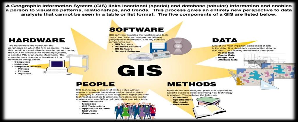
7 GIS Components


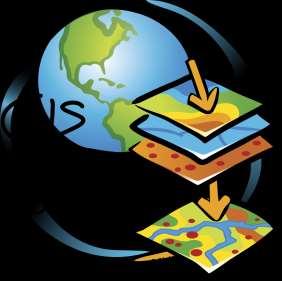
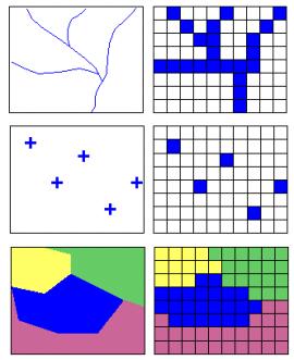
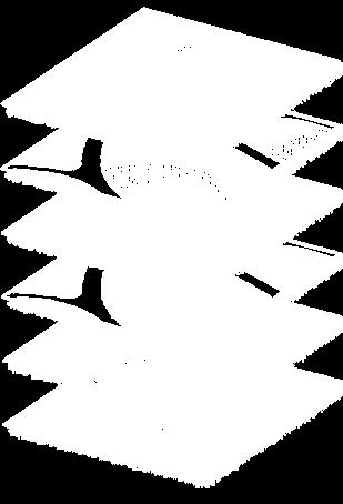
8 The Basic Principle A GIS map contains layers

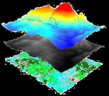
9 A layers that contains many of the same types of things, like coal basins, transmission lines, states, and lakes, is called a feature. Layers may contain features or surfaces A layer that is not a collection of geographic objects and is considered a single, continuous expanse that change from one location to another like bathymetry and elevation, is called a surface.

10 Geographic objects have an endless variety of shapes and can be represented as one of three geometric forms: Features have shape and size Polygons: objects that are large enough to have boundaries Countries, lakes, and tracks of land Lines: objects that are relatively too narrow to be polygons Rivers, roads, and pipelines Points: objects that are relatively too small to be polygons Cities, schools, fire hydrant These features are collectively called vector data.

11 Surfaces have numeric values rather than shapes Natural phenomena, such elevation, slope, temperature, rainfall, and wind speed, have no distinct shape. They have instead measurable values for any location on the Earth s surface. The most common kind of surface is a raster, a matrix of identically sized squared cells. Each cell represents a unit of surface area.


12 Vector vs. Raster Which is the best format?

13 Features have locations A graticule is a grid over the world map that indicates a certain number of marks up or down from and to the right or left of a given starting point. This kind of grid is called a coordinate system, and it is what a GIS uses to put features in their proper place on a map.


14 Features can be displayed at different sizes Scale, commonly expressed as a ratio, is the relationship between the size of the features on a map and the size of the corresponding places in the world.

15 Features are linked to information Attribute table

16 Features have spatial relationships
17 New features can be created from areas of overlap


18 New features can be created from areas of overlap
19 IDRISI MapInfo Examples of GIS Software GRASS GIS grass.osgeo.org/ QGIS ArcGIS

20 ArcGIS from ESRI
 in 1969 as a small research group focused on land-use planning.")

21 History of ESRI Jack and Laura Dangermond founded Environmental Systems Research Institute (ESRI) in 1969 as a small research group focused on land-use planning. The company's early mission was to organize and analyze geographic information to help land planners and land resource managers make well-informed environmental decisions.

22 History of ESRI 1982 Esri enters the software business with ARC/INFO.

23 History of ESRI 1986 Esri releases PC ARC/INFO in response to the proliferation of IBM PCs.

24 History of ESRI 1991 Esri releases ArcView in response to the popularity of a GUI desktop environment.

25 History of ESRI 2004 ArcGIS 9 builds on desktop success and adds a development framework and server platform.

26 History of ESRI 2012 ArcGIS 10.1 debuts, enabling users to deliver any GIS resource as a web service, putting geographic information in the hands of more people.

27 History of ESRI 2014

28 History of ESRI
 ArcMap ArcCatalog ArcGlobe ArcScene Spatial Analyst 3D Analyst")
29 ArcGIS Desktop ArcGIS Desktop ArcReader (Free) ArcView (Basic) ArcEditor (Standard) ArcInfo (Advanced) ArcMap ArcCatalog ArcGlobe ArcScene Spatial Analyst 3D Analyst Others
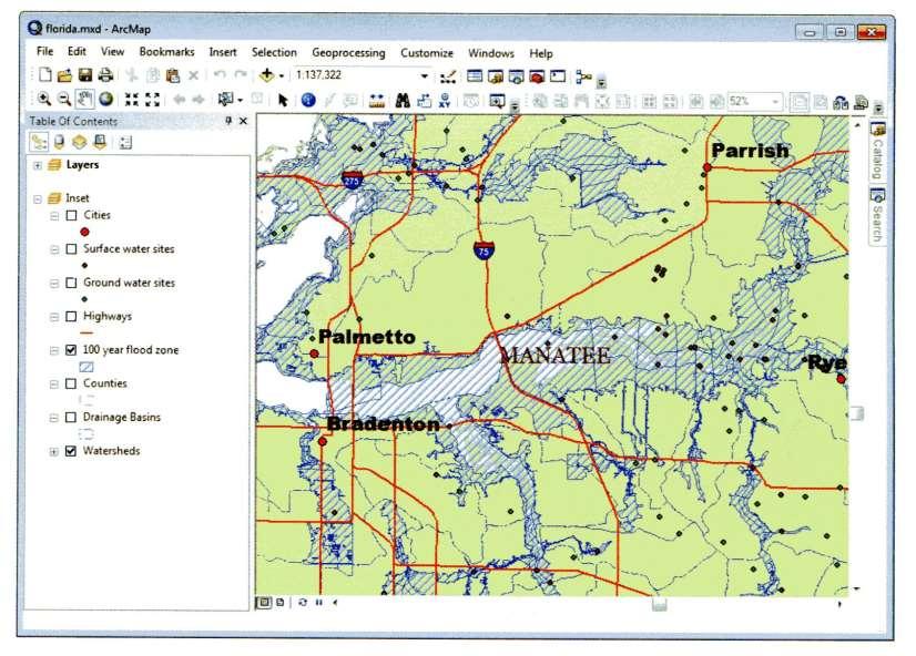
30 ArcMap
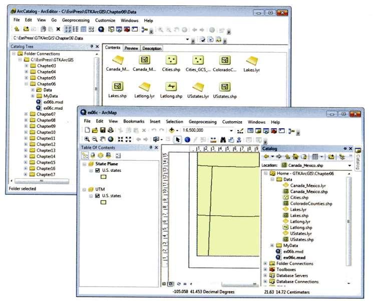
31 ArcCatalog
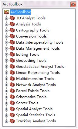
32 ArcToolbox


33 ArcGIS Mobile The increasing portability of GPS receivers has enable laptops, PDAs, and cellular phones to link precise, real-time, locational information to a GIS. o Enter new data as it directly observed o Verify or update information already in the system o Valuable for registering digital images or satellite imagery o Provides immediate on-site access to spatial data in the field

34 ArcGIS Server

35 Online GIS

36 Any question?
Techniques for Science Teachers: Using GIS in Science Classrooms.
 Techniques for Science Teachers: Using GIS in Science Classrooms. After ESRI, 2008 GIS A Geographic Information System A collection of computer hardware, software, and geographic data used together for
Display data in a map-like format so that geographic patterns and interrelationships are visible
 Vilmaliz Rodríguez Guzmán M.S. Student, Department of Geology University of Puerto Rico at Mayagüez Remote Sensing and Geographic Information Systems (GIS) Reference: James B. Campbell. Introduction to
Popular Mechanics, 1954
 Introduction to GIS Popular Mechanics, 1954 1986 $2,599 1 MB of RAM 2017, $750, 128 GB memory, 2 GB of RAM Computing power has increased exponentially over the past 30 years, Allowing the existence of
UNIT 4: USING ArcGIS. Instructor: Emmanuel K. Appiah-Adjei (PhD) Department of Geological Engineering KNUST, Kumasi
 Department of Geological Engineering KNUST, Kumasi") UNIT 4: USING ArcGIS Instructor: Emmanuel K. Appiah-Adjei (PhD) Department of Geological Engineering KNUST, Kumasi Getting to Know ArcGIS ArcGIS is an integrated collection of GIS software products ArcGIS
UNIT 4: USING ArcGIS Instructor: Emmanuel K. Appiah-Adjei (PhD) Department of Geological Engineering KNUST, Kumasi Getting to Know ArcGIS ArcGIS is an integrated collection of GIS software products ArcGIS
Lecture 1 Introduction to GIS. Dr. Zhang Spring, 2017
 Lecture 1 Introduction to GIS Dr. Zhang Spring, 2017 Topics of the course Using and making maps Navigating GIS Map design Working with spatial data Geoprocessing Spatial data infrastructure Digitizing
Welcome to NR502 GIS Applications in Natural Resources. You can take this course for 1 or 2 credits. There is also an option for 3 credits.
 Welcome to NR502 GIS Applications in Natural Resources. You can take this course for 1 or 2 credits. There is also an option for 3 credits. The 1st credit consists of a series of readings, demonstration,
University of Lusaka
 University of Lusaka BSPH 315 Health Mapping & GIS Topic: Background of GIS Content: 1. Aim of the course 2. What do you know about GIS? 3. Difference between geographic data and geographic information
NR402 GIS Applications in Natural Resources
 NR402 GIS Applications in Natural Resources Lesson 1 Introduction to GIS Eva Strand, University of Idaho Map of the Pacific Northwest from http://www.or.blm.gov/gis/ Welcome to NR402 GIS Applications in
GEOGRAPHIC INFORMATION SYSTEMS
 GEOGRAPHIC INFORMATION SYSTEMS 4-H Round-Up Community Transitions Workshop Daniel Hanselka June 14, 2011 Goals of the Workshop Answer the question: What is GIS? Uses of GIS. Some of the Common Terminology
INTRODUCTION TO ARCGIS Version 10.*
 Week 3 INTRODUCTION TO ARCGIS Version 10.* topics of the week Overview of ArcGIS Using ArcCatalog Overview of ArcGIS Desktop ArcGIS Overview Scalable desktop applications ArcView ArcEditor ArcInfo ArcGIS
GIS Boot Camp for Education June th, 2011 Day 1. Instructor: Sabah Jabbouri Phone: (253) x 4854 Office: TC 136
 x 4854 Office: TC 136") GIS Boot Camp for Education June 27-30 th, 2011 Day 1 Instructor: Sabah Jabbouri Phone: (253) 833-9111 x 4854 Office: TC 136 Email: sjabbouri@greenriver.edu http://www.instruction.greenriver.edu/gis/ Summer
GIS Boot Camp for Education June 27-30 th, 2011 Day 1 Instructor: Sabah Jabbouri Phone: (253) 833-9111 x 4854 Office: TC 136 Email: sjabbouri@greenriver.edu http://www.instruction.greenriver.edu/gis/ Summer
GIS Workshop Data Collection Techniques
 GIS Workshop Data Collection Techniques NOFNEC Conference 2016 Presented by: Matawa First Nations Management Jennifer Duncan and Charlene Wagenaar, Geomatics Technicians, Four Rivers Department QA #: FRG
What is GIS? G: Geographic, Geospatial, Geo
 GEOG 488/588: GIS I Introduction Instructor: Geoffrey Duh TA: David Graves What is GIS? G: Geographic, Geospatial, Geo Alternatives: Spatial Information Systems, Land Information Systems Geography diverse
GIS = Geographic Information Systems;
 What is GIS GIS = Geographic Information Systems; What Information are we talking about? Information about anything that has a place (e.g. locations of features, address of people) on Earth s surface,
8/28/2011. Contents. Lecture 1: Introduction to GIS. Dr. Bo Wu Learning Outcomes. Map A Geographic Language.
 Contents Lecture 1: Introduction to GIS Dr. Bo Wu lsbowu@polyu.edu.hk Department of Land Surveying & Geo-Informatics The Hong Kong Polytechnic University 1. Learning outcomes 2. GIS definition 3. GIS examples
GIS MANUAL VOLUME I DEPARTMENT OF GEOGRAPHY UNIVERSITY OF COLOMBO. L. Manawadu V.P.I.S. Wijeratne S.M.A.T. Nandaseela P. Ranasinghe M.A.D.
 i 2016 GIS MANUAL VOLUME I L. Manawadu V.P.I.S. Wijeratne S.M.A.T. Nandaseela P. Ranasinghe M.A.D. Samanmali ii TABLE OF CONTENT 01 INTRODUCTION TO GIS 01 1.1.Introduction 01 1.2.Definition and Overview
Oakland County Parks and Recreation GIS Implementation Plan
 Oakland County Parks and Recreation GIS Implementation Plan TABLE OF CONTENTS 1.0 Introduction... 3 1.1 What is GIS? 1.2 Purpose 1.3 Background 2.0 Software... 4 2.1 ArcGIS Desktop 2.2 ArcGIS Explorer
How does ArcGIS Server integrate into an Enterprise Environment? Willy Lynch Mining Industry Specialist ESRI, Denver, Colorado USA
 How does ArcGIS Server integrate into an Enterprise Environment? Willy Lynch Mining Industry Specialist ESRI, Denver, Colorado USA wlynch@esri.com ArcGIS Server Technology Transfer 1 Agenda Who is ESRI?
HISTORY OF GIS AND ESRI
 HISTORY OF GIS AND ESRI First Developed by Dr. Roger Tomlinson in Canada 1960 (CGIS Canadian geographic system) The system was designed to inventory land use and assist in the management of natural resources
Advanced Algorithms for Geographic Information Systems CPSC 695
 Advanced Algorithms for Geographic Information Systems CPSC 695 Think about Geography What is Geography The 3 W s of Geography What is where Why is it there Why do I care Data - Data - Data We all got
ArcGIS. for Server. Understanding our World
 ArcGIS for Server Understanding our World ArcGIS for Server Create, Distribute, and Manage GIS Services You can use ArcGIS for Server to create services from your mapping and geographic information system
Applications: Introduction Task 1: Introduction to ArcCatalog Task 2: Introduction to ArcMap Challenge Question References
 CHAPTER 1 INTRODUCTION 1.1 GIS? 1.1.1 Components of a GIS 1.1.2 A Brief History of GIS 1.1.3 GIS Software Products Box 1.1 A List of GIS Software Producers and Their Main Products 1.2 GIS Applications
FUNDAMENTALS OF GEOINFORMATICS PART-II (CLASS: FYBSc SEM- II)
") FUNDAMENTALS OF GEOINFORMATICS PART-II (CLASS: FYBSc SEM- II) UNIT:-I: INTRODUCTION TO GIS 1.1.Definition, Potential of GIS, Concept of Space and Time 1.2.Components of GIS, Evolution/Origin and Objectives
FUNDAMENTALS OF GEOINFORMATICS PART-II (CLASS: FYBSc SEM- II) UNIT:-I: INTRODUCTION TO GIS 1.1.Definition, Potential of GIS, Concept of Space and Time 1.2.Components of GIS, Evolution/Origin and Objectives
Section 1: Getting to know GIS. Chapter 1. Introducing GIS
 Section 1: Getting to know GIS Chapter 1 Introducing GIS 2 Section 1: Getting to know GIS For a long time, people have studied the world using models such as maps and globes. In the last thirty years or
Lecture 2. Introduction to ESRI s ArcGIS Desktop and ArcMap
 Lecture 2 Introduction to ESRI s ArcGIS Desktop and ArcMap Outline ESRI What is ArcGIS? ArcGIS Desktop ArcMap Overview Views Layers Attribute Tables Help! Scale Tips and Tricks ESRI Environmental Systems
ENV208/ENV508 Applied GIS. Week 1: What is GIS?
 ENV208/ENV508 Applied GIS Week 1: What is GIS? 1 WHAT IS GIS? A GIS integrates hardware, software, and data for capturing, managing, analyzing, and displaying all forms of geographically referenced information.
What are the five components of a GIS? A typically GIS consists of five elements: - Hardware, Software, Data, People and Procedures (Work Flows)
") LECTURE 1 - INTRODUCTION TO GIS Section I - GIS versus GPS What is a geographic information system (GIS)? GIS can be defined as a computerized application that combines an interactive map with a database
LECTURE 1 - INTRODUCTION TO GIS Section I - GIS versus GPS What is a geographic information system (GIS)? GIS can be defined as a computerized application that combines an interactive map with a database
What is GIS and How Can It Help Me?
 esri European User Conference Madrid 2011 What is GIS and How Can It Help Me? Jaime Nieves Ignacio Vázquez esri spain «Knowing where things are, and why, is essential to rational decision making.» Jack
Introduction-Overview. Why use a GIS? What can a GIS do? Spatial (coordinate) data model Relational (tabular) data model
 data model Relational (tabular) data model") Introduction-Overview Why use a GIS? What can a GIS do? How does a GIS work? GIS definitions Spatial (coordinate) data model Relational (tabular) data model intro_gis.ppt 1 Why use a GIS? An extension
Introduction-Overview Why use a GIS? What can a GIS do? How does a GIS work? GIS definitions Spatial (coordinate) data model Relational (tabular) data model intro_gis.ppt 1 Why use a GIS? An extension
Getting to know GIS. Chapter 1. Introducing GIS. Part 1. Learning objectives
 Part Getting to know GIS Chapter Introducing GIS Learning objectives Learn the uses of geographic information systems (GIS) Learn how GIS layers work Differentiate between GIS features and surfaces Obtain
Applying ArcGIS Online for Establishing Hanoi Agriculture Map
 Applying ArcGIS Online for Establishing Hanoi Agriculture Map Thanh Xuan Nguyen Geography Department Hanoi National University of Education mrthanhxuan@gmail.com Tien Yin Chou GIS Research Center Feng
Key Questions and Issues. What is GIS? GIS is to geographic analysis as: What is GIS? 9/3/2013. GEO 327G/386G, UT Austin 1
 What is GIS? Key Questions and Issues Geology Elevation Transportation Hydrography Imagery What is GIS? What are the applications of GIS? How is the real world represented in GIS? What analyses can GIS
Introduction to Geographic Information Systems
 Introduction to Geographic Information Systems Lynn_Carlson@brown.edu 401-863-9917 The Environmental And Remote TecHnologies Lab MacMillan Hall, Room 105 http://www.brown.edu/research/earthlab/ Outline
ESRI Survey Summit August Clint Brown Director of ESRI Software Products
 ESRI Survey Summit August 2006 Clint Brown Director of ESRI Software Products Cadastral Fabric How does Cadastral fit with Survey? Surveyors process raw field observations Survey measurements define high-order
ISSUES AND APPROACHES TO COUPLING GIS TO AN IRRIGATION DISTRIBUTION NETWORK AND SEEPAGE LOSS MODELS ABSTRACT
 ISSUES AND APPROACHES TO COUPLING GIS TO AN IRRIGATION DISTRIBUTION NETWORK AND SEEPAGE LOSS MODELS Yanbo Huang 1, Milton Henry 2, David Flahive 3, Guy Fipps 4 ABSTRACT Geographic Information Systems (GIS)
Week 01 Lecture Notes Antelope Valley College Geography 205
 I. Introduction to GIS a. Tonight we ll discuss i. What GIS is and isn t ii. Software iii. Data iv. Documents v. File Structure II. GIS a. What it is i. Geographic Information Systems ii. A way of storing,
ESRI educational site license in Bahir Dar University. Tegegn Molla Abebe Mengaw Geospatial Data and Technology Center, BDU
 ESRI educational site license in Bahir Dar University Tegegn Molla Abebe Mengaw Geospatial Data and Technology Center, BDU September, 2016 Mission, Vision Purpose and Values of the GDTC Mission of GDTC
Geographical Information System GIS
 Geographical Information System GIS LOOM.02.331 anto.aasa@ut.ee Scale GIS and spatial planning National Regional Local Strategic (National Dev. Plan) National Goals and development policy Tactical (Regional
GED 554 IT & GIS INTRODUCTION TO THE COURSE CHAPTER 1
 GED 554 IT & GIS INTRODUCTION TO THE COURSE CHAPTER 1 March 1, 2013 Lines before starting class 1. Initial Introductions 2. Usage of the building 3. Assistance 4. Timetable 5. Curriculum 6. Introduction
GIS in Weather and Society
 GIS in Weather and Society Olga Wilhelmi Institute for the Study of Society and Environment National Center for Atmospheric Research WAS*IS November 8, 2005 Boulder, Colorado Presentation Outline GIS basic
Introduction to GIS. Phil Guertin School of Natural Resources and the Environment GeoSpatial Technologies
 Introduction to GIS Phil Guertin School of Natural Resources and the Environment dguertin@cals.arizona.edu Mapping GeoSpatial Technologies Traditional Survey Global Positioning Systems (GPS) Remote Sensing
A Review: Geographic Information Systems & ArcGIS Basics
 A Review: Geographic Information Systems & ArcGIS Basics Geographic Information Systems Geographic Information Science Why is GIS important and what drives it? Applications of GIS ESRI s ArcGIS: A Review
Geometric Algorithms in GIS
 Geometric Algorithms in GIS GIS Visualization Software Dr. M. Gavrilova GIS Software for Visualization ArcView GEO/SQL Digital Atmosphere AutoDesk Visual_Data GeoMedia GeoExpress CAVE? Visualization in
ArcGIS Tools for Professional Cartography
 ArcGIS Tools for Professional Cartography By Makram Murad-al-shaikh M.S. Cartography Senior instructor ESRI Educational Services ICC - A Coruña - Spain, 9-16 July, 2005 Overview Overview of the ArcGIS
Course overview. Grading and Evaluation. Final project. Where and When? Welcome to REM402 Applied Spatial Analysis in Natural Resources.
 Welcome to REM402 Applied Spatial Analysis in Natural Resources Eva Strand, University of Idaho Map of the Pacific Northwest from http://www.or.blm.gov/gis/ Where and When? Lectures Monday & Wednesday
PUBLIC OUTREACH THROUGH GIS
 PUBLIC OUTREACH THROUGH GIS Tim Witt, Department of Earth Sciences, University of South Alabama, Mobile, AL 36688. E-mail: tw501@jaguar1.usouthal.edu. In this paper, I propose a few ways, by using GIS
GIS CONCEPTS ARCGIS METHODS AND. 3 rd Edition, July David M. Theobald, Ph.D. Warner College of Natural Resources Colorado State University
 GIS CONCEPTS AND ARCGIS METHODS 3 rd Edition, July 2007 David M. Theobald, Ph.D. Warner College of Natural Resources Colorado State University Copyright Copyright 2007 by David M. Theobald. All rights
8/27/2015 M. Helper, U. Texas, Austin
 Slide 1 What is GIS? Geology Transportation Hydrography Elevation Imagery Geo327G/386G UT Austin 1 Slide 2 Key Questions and Issues What is GIS? What are the applications of GIS? How is the real world
Developing a Tactical-Level Geospatial Course for Army Engineers
 Developing a Tactical-Level Geospatial Course for Army Engineers Jared L. Ware Geospatial Information Science Program Department of Geography and Environmental Engineering United States Military Academy
An Introduction to Geographic Information System
 An Introduction to Geographic Information System PROF. Dr. Yuji MURAYAMA Khun Kyaw Aung Hein 1 July 21,2010 GIS: A Formal Definition A system for capturing, storing, checking, Integrating, manipulating,
The Emerging Role of Enterprise GIS in State Forest Agencies
 The Emerging Role of Enterprise GIS in State Forest Agencies Geographic Information System (GIS) A geographic information system (GIS) is a computer software system designed to capture, store, manipulate,
STEREO ANALYST FOR ERDAS IMAGINE Stereo Feature Collection for the GIS Professional
 STEREO ANALYST FOR ERDAS IMAGINE Stereo Feature Collection for the GIS Professional STEREO ANALYST FOR ERDAS IMAGINE Has Your GIS Gone Flat? Hexagon Geospatial takes three-dimensional geographic imaging
ASSESSMENT. Industry Solutions Harness the Power of GIS for Property Assessment
 ASSESSMENT Industry Solutions Harness the Power of GIS for Property Assessment Esri Canada has thousands of customers worldwide who are using the transforming power of GIS technology to collect, maintain,
These modules are covered with a brief information and practical in ArcGIS Software and open source software also like QGIS, ILWIS.
 Online GIS Training and training modules covered are: 1. ArcGIS, Analysis, Fundamentals and Implementation 2. ArcGIS Web Data Sharing 3. ArcGIS for Desktop 4. ArcGIS for Server These modules are covered
Rural Louisiana. A quarterly publication of the Louisiana Tech Rural Development Center
 Rural Louisiana A quarterly publication of the Louisiana Tech Rural Development Center Volume 4, No. 1, Fall 2009 Editor: Aaron K. Lusby Director, Asst. Professor Newsletter design: Stephanie Tidwell Student
Enabling ENVI. ArcGIS for Server
 Enabling ENVI throughh ArcGIS for Server 1 Imagery: A Unique and Valuable Source of Data Imagery is not just a base map, but a layer of rich information that can address problems faced by GIS users. >
GIS Software. Evolution of GIS Software
 GIS Software The geoprocessing engines of GIS Major functions Collect, store, mange, query, analyze and present Key terms Program collections of instructions to manipulate data Package integrated collection
Incorporating ArcGIS Pro in your Curriculum
 AAG, Boston 2017 April 5, 2017 Incorporating ArcGIS Pro in your Curriculum Geri Miller Agenda Concerns Acknowledged Learning curve ArcGIS Pro does not have all the tools (perception) Licensing and offline
E Geographic Information System. Created By: Freda Rocker Pearl River County Mapping
 E-9-1-1 Geographic Information System Created By: Freda Rocker Pearl River County Mapping frocker@pearlrivercounty.net Overview of Pearl River County E-9-1-1 Communications District GIS In 1998 the Pearl
2. GETTING STARTED WITH GIS
 2. GETTING STARTED WITH GIS What are geographic information systems and what are they used for? ArcGIS: ArcMap, ArcCatalog and ArcToolbox Vector data vs. raster data vs. attribute tables Polygons, polylines,
RANGE SUSTAINABILITY GIS APPLICATIONS AND ENTERPRISE IMPLEMENTATIONS
 RANGE SUSTAINABILITY GIS APPLICATIONS AND ENTERPRISE IMPLEMENTATIONS May 4, 2009 Gabe Lovasz, Geospatial Analyst, ManTech SRS Molly Rodriguez, Geospatial Analyst, ManTech SRS -In Support of- The Office
Law Enforcement Solutions and Applications
 ArcGIS for Solutions and Applications Solutions and Applications ArcGIS for Platform ArcGIS for Collection of solutions and applications for law enforcement. Built on the ArcGIS platform. For any named
GIS and GNSS Integration
 METIS Second Master Training & Seminar GIS and GNSS Integration By Eng. Ramadan Salem M. Sc. Surveying and Geodesy Email: ramadan_salem@link.net Page 1 GIS and GNSS Integration: Plan of the Presentation
Introduction to the 176A labs and ArcGIS
 Introduction to the 176A labs and ArcGIS Acknowledgement: Slides by David Maidment, U Texas-Austin and Francisco Olivera (TAMU) Purpose of the labs Hands-on experience with one software pakage Introduction
Steve Pietersen Office Telephone No
 Steve Pietersen Steve.Pieterson@durban.gov.za Office Telephone No. 031 311 8655 Overview Why geography matters The power of GIS EWS GIS water stats EWS GIS sanitation stats How to build a GIS system EWS
June 19 Huntsville, Alabama 1
 June 19 Huntsville, Alabama 1 Real-Time Geospatial Data: The Fusion of PI and ArcGIS Enabling Smarter Facilities Management OSIsoft and Esri Mapping and Location Analytics Platform Supporting Your Use
GIS CONCEPTS ARCGIS METHODS AND. 2 nd Edition, July David M. Theobald, Ph.D. Natural Resource Ecology Laboratory Colorado State University
 GIS CONCEPTS AND ARCGIS METHODS 2 nd Edition, July 2005 David M. Theobald, Ph.D. Natural Resource Ecology Laboratory Colorado State University Copyright Copyright 2005 by David M. Theobald. All rights
John Laznik 273 Delaplane Ave Newark, DE (302)
") Office Address: John Laznik 273 Delaplane Ave Newark, DE 19711 (302) 831-0479 Center for Applied Demography and Survey Research College of Human Services, Education and Public Policy University of Delaware
Office Address: John Laznik 273 Delaplane Ave Newark, DE 19711 (302) 831-0479 Center for Applied Demography and Survey Research College of Human Services, Education and Public Policy University of Delaware
ISSUES AND APPROACHES TO COUPLING GIS TO IRRIGATION DISTRIBUTION NETWORK AND SEEPAGE LOSS MODELS
 ISSUES AND APPROACHES TO COUPLING GIS TO IRRIGATION DISTRIBUTION NETWORK AND SEEPAGE LOSS MODELS Yanbo Huang 1 Milton Henry 2 David Flahive 3 Guy Fipps 4 ABSTRACT There are several possible approaches
Better Topographic Map Production Using ArcGIS. A Comprehensive Solution for Mapping Organizations
 Better Topographic Map Production Using ArcGIS A Comprehensive Solution for Mapping Organizations The World Is Always Changing As a member of a national mapping organization, you know this is true. You
Outline. Chapter 1. A history of products. What is ArcGIS? What is GIS? Some GIS applications Introducing the ArcGIS products How does GIS work?
 Outline Chapter 1 Introducing ArcGIS What is GIS? Some GIS applications Introducing the ArcGIS products How does GIS work? Basic data formats The ArcCatalog interface 1-1 1-2 A history of products Arc/Info
SCHOOL OF ENGINEERING AND TECHNOLOGY COMPUTER LAB
 PHASE 1_6 TH SESSION ARCGIS TRAINING AT KU GIS LABS: INTRODUCTION TO GIS: EXPLORING ARCCATALOG AND ARCGIS TOOLS 6 TH SESSION REPORT: 3 RD -5 TH SEPTEMBER 2014 SCHOOL OF ENGINEERING AND TECHNOLOGY COMPUTER
Geospatial Fire Behavior Modeling App to Manage Wildfire Risk Online. Kenyatta BaRaKa Jackson US Forest Service - Consultant
 Geospatial Fire Behavior Modeling App to Manage Wildfire Risk Online Kenyatta BaRaKa Jackson US Forest Service - Consultant Fire Behavior Modeling and Forest Fuel Management Modeling Fire Behavior is an
Cartography with Esri Production Mapping
 Cartography with Esri Production Mapping All rights reserved. Course version 1.3. Version release date September 2015. Printed in the United States of America. The information contained in this document
COURSE INTRODUCTION & COURSE OVERVIEW
 week 1 COURSE INTRODUCTION & COURSE OVERVIEW topics of the week Instructor introduction Students introductions Course logistics Course objectives Definition of GIS The story of GIS introductions Who am
GIS and Remote Sensing
 Spring School Land use and the vulnerability of socio-ecosystems to climate change: remote sensing and modelling techniques GIS and Remote Sensing Katerina Tzavella Project Researcher PhD candidate Technology
ARCGIS TRAINING AT KU GIS LABS: INTRODUCTION TO GIS: EXPLORING ARCCATALOG AND ARCGIS TOOLS
 PHASE 1_3 rd SESSION ARCGIS TRAINING AT KU GIS LABS: INTRODUCTION TO GIS: EXPLORING ARCCATALOG AND ARCGIS TOOLS 3 rd SESSION REPORT: 25 TH -27 TH JUNE 2014 SCHOOL OF ENVIRONMENTAL STUDIES COMPUTER LAB
GIS at JLAB. T. Larrieu Jefferson Lab, Newport News, VA 23606, USA. Controls Group. October 2006 PCaPAC
 GIS at JLAB T. Larrieu Jefferson Lab, Newport News, VA 23606, USA October 2006 PCaPAC Jefferson Lab has a Large and Complex Infrastructure CEBAF ( 24/7 electron utility ) 7 km of beamline 2000+ magnets
Understanding Geographic Information System GIS
 Understanding Geographic Information System GIS What do we know about GIS? G eographic I nformation Maps Data S ystem Computerized What do we know about maps? Types of Maps (Familiar Examples) Street Maps
Image Analysis with ArcGIS. Student Edition
 Image Analysis with ArcGIS Student Edition Copyright 2016 Esri All rights reserved. Course version 2.0. Version release date May 2016. Printed in the United States of America. The information contained
Migrating from ArcMap to ArcGIS Pro
 Migrating from ArcMap to ArcGIS Pro Migrating from ArcMap to ArcGIS Pro STUDENT EDITION Table of Contents Esri resources for your organization Course introduction Course introduction Course goals Installing
DATA 301 Introduction to Data Analytics Geographic Information Systems
 DATA 301 Introduction to Data Analytics Geographic Information Systems Dr. Ramon Lawrence University of British Columbia Okanagan ramon.lawrence@ubc.ca DATA 301: Data Analytics (2) Why learn Geographic
Introduction to ArcGIS Server - Creating and Using GIS Services. Mark Ho Instructor Washington, DC
 Introduction to ArcGIS Server - Creating and Using GIS Services Mark Ho Instructor Washington, DC Technical Workshop Road Map Product overview Building server applications GIS services Developer Help resources
If you aren t familiar with Geographical Information Systems (GIS), you. GIS, when combined with a database that stores response information,
, you. GIS, when combined with a database that stores response information,") Geographical Information Systems in EMS By William E. Ott If you aren t familiar with Geographical Information Systems (GIS), you should take a look at what GIS can offer you as an EMS manager. GIS, when
Geographical Information Systems in EMS By William E. Ott If you aren t familiar with Geographical Information Systems (GIS), you should take a look at what GIS can offer you as an EMS manager. GIS, when
HIGH RESOLUTION BASE MAP: A CASE STUDY OF JNTUH-HYDERABAD CAMPUS
 HIGH RESOLUTION BASE MAP: A CASE STUDY OF JNTUH-HYDERABAD CAMPUS K.Manjula Vani, Abhinay Reddy, J. Venkatesh, Ballu Harish and R.S. Dwivedi ABSTRACT The proposed work High Resolution Base map: A Case study
September 2016 New ArcGIS Solutions
 September 2016 New ArcGIS Solutions Hydroelectric https://profservices.maps.arcgis.com/apps/mapjournal/index.html?appid=0ef98f74f8fb4f9da88 1adc521e1c90f Adopta Engage the public in the maintenance and
The Framework and Application of Geographic Information Systems (GIS)
") The Framework and Application of Geographic Information Systems (GIS) The Framework and Application of Geographic Information Systems (GIS) Part I The Geographic Framework The Geographic Framework Spatial
The Framework and Application of Geographic Information Systems (GIS) The Framework and Application of Geographic Information Systems (GIS) Part I The Geographic Framework The Geographic Framework Spatial
Introduction to Field Data Collection
 Introduction to Field Data Collection Dr. Yuji Murayama (Professor) Dr. Ko Ko Lwin (JSPS Postdoctoral Researcher) Division of Spatial Information Science Graduate School of Life and Environmental Sciences
ArcGIS Web Tools, Templates, and Solutions for Defence & Intelligence. Renee Bernstein Esri Solutions Engineer
 ArcGIS Web Tools, Templates, and Solutions for Defence & Intelligence Renee Bernstein Esri Solutions Engineer ArcGIS Solutions Includes 450+ Industry Focused Apps and Capabilities Organized by 9 Primary
Data Aggregation with InfraWorks and ArcGIS for Visualization, Analysis, and Planning
 Data Aggregation with InfraWorks and ArcGIS for Visualization, Analysis, and Planning Stephen Brockwell President, Brockwell IT Consulting, Inc. Join the conversation #AU2017 KEYWORD Class Summary Silos
GEOGRAPHIC INFORMATION SYSTEM (GES203)
") GEOGRAPHIC INFORMATION SYSTEM (GES203) GIS Components Level 2:1 By: Mrs Mupfiga Presentation Layout Recap Learning Objectives Components of GIS GIS Data References Lecture Evaluation Learning Objectives
GEOGRAPHIC INFORMATION SYSTEM (GES203) GIS Components Level 2:1 By: Mrs Mupfiga Presentation Layout Recap Learning Objectives Components of GIS GIS Data References Lecture Evaluation Learning Objectives
Introduction to the 176A labs and ArcGIS Purpose of the labs
 Introduction to the 176A labs and ArcGIS Purpose of the labs Acknowledgement: Slides by David Maidment, U Texas-Austin and Francisco Olivera (TAMU) Hands-on experience with a leading software package Introduction
Teaching GIS for Land Surveying
 Teaching GIS for Land Surveying Zhanjing (John) Yu Evergreen Valley College, San Jose, California James Crossfield California State University at Fresno, Fresno California 7/13/2006 1 Outline of the Presentation
EnvSci 360 Computer and Analytical Cartography
 EnvSci 360 Computer and Analytical Cartography Lecture 7 Mapping Images, Surfaces, and 3-D Data Brief Overview of Imagery What is Imagery? A spatial data model that defines space as an array of equally
ARCGIS TRAINING AT KU GIS LABS: INTRODUCTION TO GIS: EXPLORING ARCCATALOG AND ARCGIS TOOLS
 PHASE 1_4 th SESSION ARCGIS TRAINING AT KU GIS LABS: INTRODUCTION TO GIS: EXPLORING ARCCATALOG AND ARCGIS TOOLS 4 th SESSION REPORT: 30 TH JUNE - 2 ND JULY SCHOOL OF ENVIRONMENTAL STUDIES COMPUTER LAB
SRJC Applied Technology 54A Introduction to GIS
 SRJC Applied Technology 54A Introduction to GIS Overview Lecture of Geographic Information Systems Fall 2004 Santa Rosa Junior College Presented By: Tim Pudoff, GIS Coordinator, County of Sonoma, Information
Louisiana Transportation Engineering Conference. Monday, February 12, 2007
 Louisiana Transportation Engineering Conference Monday, February 12, 2007 Agenda Project Background Goal of EIS Why Use GIS? What is GIS? How used on this Project Other site selection tools I-69 Corridor
Deploying Portal for ArcGIS STUDENT EDITION
 Deploying Portal for ArcGIS STUDENT EDITION Copyright 2016 Esri All rights reserved. Course version 2.0.1. Version release date November 2016. Printed in the United States of America. The information contained
A Technique for Importing Shapefile to Mobile Device in a Distributed System Environment.
 A Technique for Importing Shapefile to Mobile Device in a Distributed System Environment. 1 Manish Srivastava, 2 Atul Verma, 3 Kanika Gupta 1 Academy of Business Engineering and Sciences,Ghaziabad, 201001,India
Lecture 2. A Review: Geographic Information Systems & ArcGIS Basics
 Lecture 2 A Review: Geographic Information Systems & ArcGIS Basics GIS Overview Types of Maps Symbolization & Classification Map Elements GIS Data Models Coordinate Systems and Projections Scale Geodatabases