Lu, S., P. Craig, C. Wallen, Z. Liu, A. Stoddard, W. McAnnally and E. Maak. Dynamic Solutions, Knoxville, TN USACOE, Sacramento District
|
|
|
- Bruce Patterson
- 6 years ago
- Views:
Transcription


1 An Extended-Delta Hydrodynamic Model Framework for Sea Level Rise Analysis to Support Resource Management Planning for the Sacramento-San Joaquin River Delta Lu, S., P. Craig, C. Wallen, Z. Liu, A. Stoddard, W. McAnnally and E. Maak Dynamic Solutions, Knoxville, TN USACOE, Sacramento District CWEMF 2012 Folsom, CA 16 April 2012 US Army Corps of Engineers
2 Climate Change Issues Global Warming Precipitation Hydrology Water Resources Flood Protection Sea Level Rise
3 Sacramento-San Joaquin Delta 3D EFDC Model Framework Hydrodynamic, sediment and water quality model developed by U.S. Army Corps of Engineers, Sacramento District to provide 3D modeling tool for planning evaluations & resource management Delta Model domain includes Sacramento River (Verona)-San Joaquin River (Vernalis) Delta- Suisun Bay-Carquinez Strait Environmental Fluid Dynamics Code (EFDC)
4 EFDC Model Hydrodynamics Water Quality WATERSHED RUNOFF Sediment Transport Toxics HYDRODYNAMICS water column SEDIMENT TRANSPORT Non-cohesive solids Cohesive solids deposition resuspension solids TOXIC CHEMICAL TRANSPORT & FATE Dissolved toxic Sorbed toxic deposition resuspension diffusion POC DOC CONVENTIONAL POLLUTANTS & EUTROPHICATION Carbon Nitrogen Phosphorus Oxygen Algae POC deposition resuspension diffusion SEDIMENT DIAGENESIS surface bed Solids in surface bed solids Dissolved toxic Sorbed toxic POC Carbon Nitrogen Phosphorus Oxygen burial bioturbation burial diffusion bioturbation deep bed Solids in deep bed solids Dissolved toxic Sorbed toxic burial
5 Extended-Delta EFDC Hydrodynamic Model Developed to evaluate potential impacts of Sea Level Rise on water level and salinity intrusion Domain extended to include San Pablo Bay, San Francisco Bay and Pacific Ocean 27 miles offshore to Farallon Islands Finer grid used for center deep channels in San Francisco Bay and San Pablo Bay
6 Extended-Delta EFDC Hydrodynamic Model Verona N=21,421 horizontal Cell Indexes cells 4 layers (Sigma Grid) Carquinez Strait Farallon Islands Vernalis Kilometers BUILDING STRONG

7 BUILDING STRONG
8 Extended Delta EFDC Model Model Calibration (2004) Open ocean BC: water level at Point Reyes; water temperature & salinity at Farallon Is. Selected calibration results Water surface elevation Salinity 2004 calibration data used as base case for SLR scenarios
9 Water Surface Elevation (m) Water Surface Elevation Golden Gate, Oct Legend Golden Gate-Model Golden Gate-Data /01/ /08/ /15/ /22/ /29/2004 Date RMS=0.05 m; Relative RMS Error=1.6%
10 Water Surface Elevation (m) Water Surface Elevation Mallard Island (MAL) hr Filtered Jan-Dec Legend MAL-Model (24.75 hrs MA) MAL-Data (24.75 hrs MA) Jan-04 Mar-04 May-04 Jul-04 Sep-04 Nov-04 Date RMS=0.06 m; Relative RMS Error=3.6%
11 Salinity (ppt) Surface Salinity Port San Pablo (PSP) hr Filtered Jan-Dec Legend PSP-Model (Layer 4) (24.75 hrs MA) PSP-Data (24.75 hrs MA) Jan-04 Mar-04 May-04 Jul-04 Sep-04 Nov-04 Date RMS=2.3 ppt; Relative RMS Error=8.1%
12 Salinity (ppt) Bottom Salinity Mallard Island (MAL) hr Filtered Jan-Dec Legend MAL-Model (Layer 1) (24.75 hrs MA) MAL-Data (24.75 hrs MA) Jan-04 Mar-04 May-04 Jul-04 Sep-04 Nov-04 Date RMS=1.8 ppt; Relative RMS Error=9.3%
13 Extended Delta EFDC Model Sea Level Rise Analysis 3D 4-layer model-> barotropic/baroclinic flow Freshwater (Flow, T,S) and offshore open BC (T,S) from 2004 calibration (Base Case) Open BC for Water Level based on 2004 tide signal at Point Reyes + SLR (50, 100 yr) Land subsidence rate of 1.5 mm/yr defines offset in bathymetry of m for 100 yr case
 based on global temperature rise 1.")
14 Sea Level Rise: Historical & Projections (Rahmstorf, 2007) IPCC global mean temperature projections Uncertainty range (gray) based on global temperature rise 1.4 to 5.8 Deg-C

15 Extended Delta EFDC Model SLR Analysis (9 Cases)
16 SLR Impact Metrics Max Difference in Water Level & Depth-Avg Salinity tracked at each grid cell as [SLR Scenario Base Case] over simulation period (Jan-Dec 2004) Bottom salinity sections: Golden Gate to Sacramento; Golden Gate to Clifton Court; wet spring & dry summer conditions
17 SLR Impact on Water Level
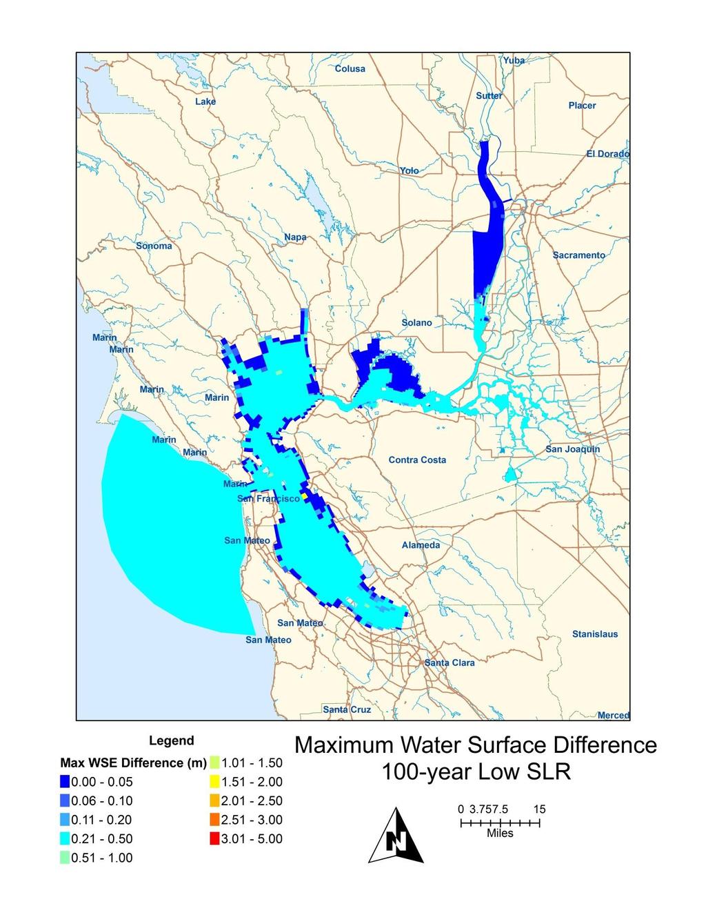
18 0.20 m
19 0.52 m
20 1.68 m
21 1.68 m; m
22 SLR Impact on Water Level Findings Suisun Bay and South Yolo Bypass areas show largest Water Level impact from SLR Suisun Bay: largest increases during summer low flow from rivers; large shallow mud flats of marsh amplify tide signal with maximumwater Level related to low flow South Yolo Bypass: largest increase along fresh-salt water interface in wet spring season
23 SLR Impact on Salinity
24 BUILDING STRONG
25 BUILDING STRONG
26 BUILDING STRONG
27 BUILDING STRONG
28 SLR Impact on Salinity Findings Bottom salinity increased in SF Bay and Delta by ppt; Suisun Bay, San Pablo Bay & Carquinez Strait show largest salinity impact during wet spring conditions
29 Salinity (ppt) 100 Yr,High SLR,Subsidence Flood Tide (3/1/ :00) Golden Gate to Sacramento Base 100 Year High SLR with Subsidence Suisun Bay/ Port Chicago Rio Vista Delta Cross Channel Hood Golden Gate Bridge Sacramento Distance Along Drape Line (m)
30 Salinity (ppt) 100 Yr,High SLR,Subsidence Ebb Tide (7/3/ :00) Golden Gate to Sacramento Base 100 Year High SLR with Subsidence Suisun Bay/ Port Chicago Rio Vista Delta Cross Channel Hood Golden Gate Bridge Sacramento Distance Along Drape Line (m)
31 SLR Impact on Salinity Findings Shift in bottom salinity intrusion for 2 ppt location for 100 Yr High SLR (1.68 m) with subsidence compared to Base Case: ~ 12 km for dry summer conditions/ebb tide ~ 10 km for wet spring conditions/flood tide
32 Extended Delta EFDC Model Summary Provides USACOE Sacramento District, other Federal/State agencies and Stakeholders with an advanced 3D model framework Essential tool for increased understanding of consequences of natural events and issues such as SLR for planning level evaluations Sets standard for determination of significance of project impacts
33 Discussion Contact Information: Dynamic Solutions Andrew Stoddard (540) USACE Sacramento District Gene Maak (916) US Army Corps of Engineers
Technical Memo: Initial Modeling of Levee Breaches. Prepared for: Delta Levees Risk Assessment Team
 RMA RESOURCE MANAGEMENT ASSOCIATES, INC. FAIRFIELD, CALIFORNIA Technical Memo: Initial Modeling of Levee Breaches Prepared for: Delta Levees Risk Assessment Team January 24 DELTA LEVEES RISK ASSESSMENT
FORECAST-BASED OPERATIONS AT FOLSOM DAM AND LAKE
 FORECAST-BASED OPERATIONS AT FOLSOM DAM AND LAKE 255 237 237 237 217 217 217 200 200 200 0 163 131 Bridging the Gap163Conference 255 0 132 255 0 163 122 The Dana on Mission Bay San Diego, CA January 28,
Chiang Rai Province CC Threat overview AAS1109 Mekong ARCC
 Chiang Rai Province CC Threat overview AAS1109 Mekong ARCC This threat overview relies on projections of future climate change in the Mekong Basin for the period 2045-2069 compared to a baseline of 1980-2005.
Integrating Weather Forecasts into Folsom Reservoir Operations
 Integrating Weather Forecasts into Folsom Reservoir Operations California Extreme Precipitation Symposium September 6, 2016 Brad Moore, PE US Army Corps of Engineers Biography Brad Moore is a Lead Civil
WIND EFFECTS ON CHEMICAL SPILL IN ST ANDREW BAY SYSTEM
 WIND EFFECTS ON CHEMICAL SPILL IN ST ANDREW BAY SYSTEM PETER C. CHU, PATRICE PAULY Naval Postgraduate School, Monterey, CA93943 STEVEN D. HAEGER Naval Oceanographic Office, Stennis Space Center MATHEW
Three main areas of work:
 Task 2: Climate Information 1 Task 2: Climate Information Three main areas of work: Collect historical and projected weather and climate data Conduct storm surge and wave modeling, sea-level rise (SLR)
9 th INTECOL Orlando, Florida June 7, 2012
 Restoration of the Everglades Saline Wetlands and Florida Bay: Responses Driven from Land and Sea David Rudnick 1, Colin Saunders 2, Carlos Coronado 2, Fred Sklar 2 Erik Stabenau 1, Vic Engel 1, Rene Price
Modeling the Effects of Climate and Land Cover Change in the Stoney Brook Subbasin of the St. Louis River Watershed
 Modeling the Effects of Climate and Land Cover Change in the Stoney Brook Subbasin of the St. Louis River Watershed Joe Johnson and Jesse Pruette 214 NASA Research Internship Geospatial Technologies Program
A process-based approach toward assessing the coastal impact of projected sea level rise and severe storms
 A process-based approach toward assessing the coastal impact of projected sea level rise and severe storms Patrick Barnard 1, Cheryl Hapke 2, Li Erikson 1, Amy Foxgrover 1, and Maarten van Ormondt 3 1
Folsom Dam Water Control Manual Update Joint Federal Project, Folsom Dam
 Folsom Dam Water Control Manual Update Joint Federal Project, Folsom Dam Public Workshop May 25, 2016 Sacramento Library Galleria 828 I Street, Sacramento, CA US Army Corps of Engineers BUILDING STRONG
PRESENTATION TITLE. Regional Sediment Management Application of a Coastal Model at the St. Johns River Entrance BUILDING STRONG
 PRESENTATION TITLE Regional Sediment Management Application of a Coastal Model at the St. Johns River Entrance Steven Bratos Senior Coastal Engineer U.S. Army Corps of Engineers Jacksonville District February
Semi-enclosed seas. Estuaries are only a particular type of semi-enclosed seas which are influenced by tides and rivers
 Semi-enclosed seas Estuaries are only a particular type of semi-enclosed seas which are influenced by tides and rivers Other semi-enclosed seas vary from each other, mostly by topography: Separated from
Savannah Harbor Expansion Project
 Savannah Harbor Expansion Project Evaluation of Hurricane Surge Impacts with Proposed Mitigation Plan December 2007 Introduction This report summarizes the results of hurricane surge impacts with implementation
UC Davis San Francisco Estuary and Watershed Science
 UC Davis San Francisco Estuary and Watershed Science Title Three-dimensional Modeling of Tidal Hydrodynamics in the San Francisco Estuary Permalink https://escholarship.org/uc/item/9rv243mg Journal San
The Field Research Facility, Duck, NC Warming Ocean Observations and Forecast of Effects
 The Field Research Facility, Duck, NC Warming Ocean Observations and Forecast of Effects A potential consequence of a warming ocean is more frequent and more intense wind events (Hurricanes & Typhoons)
Connec&ng phosphorus loads to cyanobacteria biomass using the Western Lake Erie Ecosystem Model
 Connec&ng phosphorus loads to cyanobacteria biomass using the Western Lake Erie Ecosystem Model John F. Bra?on Edward M. Verhamme, Todd M. Redder, Derek A. Schlea, Jeremy Grush, and Joseph DePinto Western
RMA. Comparing Salinity and Hydrodynamics in the Historical and Contemporary Deltas
 Comparing Salinity and Hydrodynamics in the Historical and Contemporary Deltas Stephen Andrews, Ph.D. Ed Gross, Ph.D. John DeGeorge, Ph.D., P.E. Stacie Grinbergs, P.E. Outline Project Goals Model information
Aquatic Transfer Facility (ATF) San Pablo Bay (SPB) Proposed Region of ATF. Proposed Seabed Pipeline
 San Pablo Bay (SPB) Proposed Region of ATF. Proposed Seabed Pipeline") Aquatic Transfer Facility (ATF) San Pablo Bay (SPB) Proposed Region of ATF Proposed Seabed Pipeline Technical Studies An Overview Scope: Provide background and new scientific information and analysis for
Aquatic Transfer Facility (ATF) San Pablo Bay (SPB) Proposed Region of ATF Proposed Seabed Pipeline Technical Studies An Overview Scope: Provide background and new scientific information and analysis for
Towards the Development of the National Ocean Service San Francisco Bay Operational Forecast System
 J. Mar. Sci. Eng. 2014, 2, 247-286; doi:10.3390/jmse2010247 Article OPEN ACCESS Journal of Marine Science and Engineering ISSN 2077-1312 www.mdpi.com/journal/jmse Towards the Development of the National
Preliminary Data Release for the Humboldt Bay Sea Level Rise Vulnerability Assessment: Humboldt Bay Sea Level Rise Inundation Mapping
 Preliminary Data Release for the Humboldt Bay Sea Level Rise Vulnerability Assessment: Humboldt Bay Sea Level Rise Inundation Mapping Prepared by: Jeff Anderson, Northern Hydrology & Engineering (jeff@northernhydrology.com)
Flooding Performance Indicator Summary. Performance indicator: Flooding impacts on riparian property for Lake Ontario and the Upper St.
 Flooding Performance Indicator Summary Performance indicator: Flooding impacts on riparian property for Lake Ontario and the Upper St. Lawrence River Technical Workgroup: Coastal TWG Research by: Baird
Folsom Dam Water Control Manual Update Joint Federal Project, Folsom Dam
 Folsom Dam Water Control Manual Update Joint Federal Project, Folsom Dam Public Workshop May 28, 2015 Library Galleria 828 I Street, Sacramento, CA US Army Corps of Engineers BUILDING STRONG WELCOME &
Oil Spill Analysis for WesPac Pittsburg Energy Infrastructure Project EIR Pittsburg, CA
 Oil Spill Analysis for WesPac Pittsburg Energy Infrastructure Project EIR 1. Introduction The following Technical Memorandum describes analysis performed by Coast & Harbor Engineering, Inc. (CHE) as a
Assessment of the Hood River Delta Hood River, Oregon
 Assessment of the Hood River Delta Hood River, Oregon Pacific Northwest Waterways Association Annual Meeting October 13, 2010 Michael McElwee, Executive Director Port of Hood River Overview U.S. Army Corps
Mercury and methylmercury transport in the Cache Creek Settling Basin, California, U.S.A.
 Mercury and methylmercury transport in the Cache Creek Settling Basin, California, U.S.A. Alpers, C.N. 1, Fleck, J.A. 1, Marvin- DiPasquale, M. 2, Beaulieu, E. 1, and Wright, S.A. 1 1 U.S. Geological Survey,
3.1 Regional Physical Setting
 Chapter 3 Hydrogeomorphic Setting This chapter describes the physical setting of the inventory area and the four physiographic regions used to categorize the geomorphology of the inventory area. The overview
MEMORANDUM FOR SWG
 MEMORANDUM FOR SWG-2007-1623 Subject: Jurisdictional Determination (JD) for SWG-2007-1623 on Interdunal Wetlands Adjacent to Traditional Navigable Waters (TNWs) Summary The U.S. Environmental Protection
Appendix G.19 Hatch Report Pacific NorthWest LNG Lelu Island LNG Maintenance Dredging at the Materials Offloading Facility
 Appendix G.19 Hatch Report Pacific NorthWest LNG Lelu Island LNG Maintenance Dredging at the Materials Offloading Facility Project Memo H345670 To: Capt. David Kyle From: O. Sayao/L. Absalonsen December
Final Report Visualizing the Output Data of SUNTANS using ArcGIS
 Final Report Visualizing the Output Data of SUNTANS using ArcGIS Dongyu Feng Austin, United States Abstract This report discusses a method of using ArcGIS to visualize the results of a numerical model
Presentation Overview. Southwestern Climate: Past, present and future. Global Energy Balance. What is climate?
 Southwestern Climate: Past, present and future Mike Crimmins Climate Science Extension Specialist Dept. of Soil, Water, & Env. Science & Arizona Cooperative Extension The University of Arizona Presentation
Research Topic Updated on Oct. 9, 2014
 Research Topic Updated on Oct. 9, 204 Mixed Cohesive/Non-cohesive Sediments Sedimentation in Estuary: Flocculation Deposition Erosion Transport Consolidation *: It has been recognized that when the fraction
Missouri River Basin Water Management Monthly Update
 Missouri River Basin Water Management Monthly Update Participating Agencies 255 255 255 237 237 237 0 0 0 217 217 217 163 163 163 200 200 200 131 132 122 239 65 53 80 119 27 National Oceanic and Atmospheric
Habitat Suitability for Forage Fishes in Chesapeake Bay
 Habitat Suitability for Forage Fishes in Chesapeake Bay Aug 2017 Jul 2019 Mary C Fabrizio Troy D Tuckey Aaron J Bever Michael L MacWilliams 21 June 2018 Photo: Chesapeake Bay Program Motivation Production
MISSISSIPPI RIVER DELTA OVERVIEW
 MISSISSIPPI RIVER DELTA OVERVIEW Science and Engineering Special Team Conference Louisiana State University October 9, 2012 Introduction Basics of the Mississippi Delta Natural and Human-Induced Land Loss
Physical Processes: What have we learned about Florida Bay in the past five years, and how is that useful to CERP planning and SFER management?
 Physical Processes: What have we learned about Florida Bay in the past five years, and how is that useful to CERP planning and SFER management? Peter B. Ortner, UM/RSMAS/CIMAS Modeling Progress Statistical
Coastal Inundation Forecasting and Community Response in Bangladesh
 WMO Coastal Inundation Forecasting and Community Response in Bangladesh Bapon (SHM) Fakhruddin Nadao Kohno 12 November 2015 System Design for Coastal Inundation Forecasting CIFDP-PSG-5, 14-16 May 2014,
Development, Testing and Application of the Multi-Block LTFATE Hydrodynamic and Sediment Transport Model
 Development, Testing and Application of the Multi-Block LTFATE Hydrodynamic and Sediment Transport Model Earl Hayter Environmental Lab October 25, 2012 LTFATE Multi-Block Hydrodynamic, Water Quality and
Changing Hydrology under a Changing Climate for a Coastal Plain Watershed
 Changing Hydrology under a Changing Climate for a Coastal Plain Watershed David Bosch USDA-ARS, Tifton, GA Jeff Arnold ARS Temple, TX and Peter Allen Baylor University, TX SEWRU Objectives 1. Project changes
Great Lakes Update. Great Lakes Winter and Spring Summary January June Vol. 187 Great Lakes Update August 2012
 Great Lakes Update Great Lakes Winter and Spring Summary January June 2012 The US Army Corps of Engineers (USACE) Detroit District monitors hydraulic and hydrologic conditions of the Great Lakes. This
Final Report V2 November 13, PREPARED BY: Tetra Tech, Inc Powers Ferry Rd. SE, Suite 202 Atlanta, Georgia Phone: (770)
") PREPARED BY: Tetra Tech, Inc. 2110 Powers Ferry Rd. SE, Suite 202 Atlanta, Georgia 30339 Phone: (770) 850-0949 Final Report V2 November 13, 2015 PREPARED FOR: Department of the Army Savannah District,
PREPARED BY: Tetra Tech, Inc. 2110 Powers Ferry Rd. SE, Suite 202 Atlanta, Georgia 30339 Phone: (770) 850-0949 Final Report V2 November 13, 2015 PREPARED FOR: Department of the Army Savannah District,
Name Period Part I: INVESTIGATING OCEAN CURRENTS: PLOTTING BUOY DATA
 Name Period Part I: INVESTIGATING OCEAN CURRENTS: PLOTTING BUOY DATA INTRODUCTION: Ocean currents are like huge rivers in the sea. They carry drifting organisms, vital dissolved chemical nutrients and
Signals of sea-level rise in Delaware and Chesapeake Bay tides
 Signals of sea-level rise in Delaware and Chesapeake Bay tides Andrew C. Ross and Raymond G. Najjar Pennsylvania State University Also thanks to Ming Li, Serena Lee, Fan Zhang, Wei Liu Observations show
Lake Tahoe Watershed Model. Lessons Learned through the Model Development Process
 Lake Tahoe Watershed Model Lessons Learned through the Model Development Process Presentation Outline Discussion of Project Objectives Model Configuration/Special Considerations Data and Research Integration
NRC Workshop Probabilistic Flood Hazard Assessment (PFHA) Jan 29-31, Mel Schaefer Ph.D. P.E. MGS Engineering Consultants, Inc.
 Jan 29-31, Mel Schaefer Ph.D. P.E. MGS Engineering Consultants, Inc.") Stochastic Event Flood Model (SEFM) Stochastic Modeling of Extreme Floods A Hydrological Tool for Analysis of Extreme Floods Mel Schaefer Ph.D. P.E. MGS Engineering Consultants, Inc. Olympia, WA NRC Workshop
Stochastic Event Flood Model (SEFM) Stochastic Modeling of Extreme Floods A Hydrological Tool for Analysis of Extreme Floods Mel Schaefer Ph.D. P.E. MGS Engineering Consultants, Inc. Olympia, WA NRC Workshop
Linking Sediment Transport in the Hudson from the Tidal River to the Estuary
 Linking Sediment Transport in the Hudson from the Tidal River to the Estuary Or, what happened to all the mud from Irene? David Ralston, Rocky Geyer, John Warner, Gary Wall Hudson River Foundation seminar
Ocean circulation, sedimentation in the San Juans - compilation of mainstream scientific literature by Dave Hyde -
 Ocean circulation, sedimentation in the San Juans - compilation of mainstream scientific literature by Dave Hyde - Salish Sea has 3 principal estuaries SG, JDF,PS San Juan Islands ocean setting uniquely
Disentangling Impacts of Climate & Land Use Changes on the Quantity & Quality of River Flows in Southern Ontario
 Disentangling Impacts of Climate & Land Use Changes on the Quantity & Quality of River Flows in Southern Ontario by Trevor Dickinson & Ramesh Rudra, Water Resources Engineering University of Guelph Acknowledgements
CHAPTER 6 & 7 VOCABULARY
 CHAPTER 6 & 7 VOCABULARY 1. Biome 2. Climate 3. Latitude 4. Altitude 5. Emergent layer 6. Epiphyte 7. Understory 8. Permafrost 9. Wetland 10.Plankton 11.Nekton 12.Benthos 13.Littoral zone 14.Benthic zone
CFD Modeling for Structure Designs in Environmental Impacts Mitigation
 CFD Modeling for Structure Designs in Environmental Impacts Mitigation June 05 Navid Nekouee, Hugo Rodriguez and Steven Davie Environmental Impact Mitigation Design Savannah Harbor Expansion Project (SHEP)
REDWOOD VALLEY SUBAREA
 Independent Science Review Panel Conceptual Model of Watershed Hydrology, Surface Water and Groundwater Interactions and Stream Ecology for the Russian River Watershed Appendices A-1 APPENDIX A A-2 REDWOOD
Quantifying i the GLRI Metric for Annual Sediment Deposition in Great Lakes Harbors:
 USACE 516(e) Annual Meeting Ann Arbor, MI (May 15, 2013) Quantifying i the GLRI Metric for Annual Sediment Deposition in Great Lakes Harbors: A Pilot Evaluation for Toledo Harbor Todd Redder Joe DePinto
Coastal Oceanography. Coastal Oceanography. Coastal Waters
 Coastal Oceanography Coastal Oceanography 95% of ocean life is in coastal waters (320 km from shore) Estuaries and wetlands are among most productive ecosystems on Earth Major shipping routes, oil and
Morphological Modeling of Inlets and Adjacent Shorelines on Engineering Timescales
 CB&I Morphological Modeling of Inlets and Adjacent Shorelines on Engineering Timescales Challenges and Model Improvements based on Recent Studies Dobrochinski, J.P.H.; Benedet, L.; Signorin, M.; Pierro,
Inter-linkage case study in Pakistan
 7 th GEOSS Asia Pacific Symposium GEOSS AWCI Parallel Session: 26-28 May, 2014, Tokyo, Japan Inter-linkage case study in Pakistan Snow and glaciermelt runoff modeling in Upper Indus Basin of Pakistan Maheswor
San Francisco Public Utilities Commission Hydrological Conditions Report For April 2014
 San Francisco Public Utilities Commission Hydrological Conditions Report For April 2014 J. Chester, C. Graham, A. Mazurkiewicz, & M. Tsang, May 13, 2014 Snow in the High Country The view from Bond Pass
A Report on a Statistical Model to Forecast Seasonal Inflows to Cowichan Lake
 A Report on a Statistical Model to Forecast Seasonal Inflows to Cowichan Lake Prepared by: Allan Chapman, MSc, PGeo Hydrologist, Chapman Geoscience Ltd., and Former Head, BC River Forecast Centre Victoria
Appendix G.18 Hatch Report Pacific NorthWest LNG Lelu Island LNG Potential Impacts of the Marine Structures on the Hydrodynamics and Sedimentation
 Appendix G.18 Hatch Report Pacific NorthWest LNG Lelu Island LNG Potential Impacts of the Marine Structures on the Hydrodynamics and Sedimentation Patterns Project Memo H345670 To: Capt. David Kyle From:
Climate Change and Water Supply Research. Drought Response Workshop October 8, 2013
 Climate Change and Water Supply Research Drought Response Workshop October 8, 2013 DWR Photo Oroville Reservoir, 2009 Talk Overview Expectations History Atmospheric Rivers and Water Supply Current Research
SUWANNEE RIVER WATER MANAGEMENT DISTRICT 9225 CR 49 LIVE OAK FLORIDA DECEMBER 2015
 HYDRODYNAMIC MODEL DEVELOPMENT, CALIBRATION, AND MFL FLOW REDUCTION AND SEA LEVEL RISE SIMULATION FOR THE TIDAL PORTION OF THE ECONFINA RIVER ECONFINA RIVER, FLORIDA SUWANNEE RIVER WATER MANAGEMENT DISTRICT
APPENDIX O. Sediment Modeling of Dredging off Lelu Island, Prince Rupert, BC Canada, and Disposal of Dredgate at Brown Passage
 APPENDIX O Sediment Modeling of Dredging off Lelu Island, Prince Rupert, BC Canada, and Disposal of Dredgate at Brown Passage Sediment Modeling of Dredging off Lelu Island, Prince Rupert, BC Canada, and
IS THERE ENOUGH SEDIMENT? Presentation at the State of the Estuary Conference San Francisco, CA, October 9-10, By Philip B.
 IS THERE ENOUGH SEDIMENT? Presentation at the State of the Estuary Conference San Francisco, CA, October 9-10, 2001 By Philip B. Williams 1. INTRO I AM TEMPTED TO MAKE THIS THE SHORTEST TALK OF THE CONFERENCE:
Generalized Conceptual Models Wetlands Regional Monitoring Program Compiled for the PEEIR
 1 Generalized Conceptual Models Wetlands Regional Monitoring Program 2002 Compiled for the PEEIR 2 1. MANAGEMENT QUESTIONS DRIVE INDICATOR DEVELOPMENT The overarching wetland management questions are:
Missouri River Basin Water Management Monthly Update
 Missouri River Basin Water Management Monthly Update Participating Agencies 255 255 255 237 237 237 0 0 0 217 217 217 163 163 163 200 200 200 131 132 122 239 65 53 80 119 27 National Oceanic and Atmospheric
Planning for the Future of Humboldt Bay: Sea Level Rise, Sediment Management, Sand Spits and Salt Marshes. Joel Gerwein
 Planning for the Future of Humboldt Bay: Sea Level Rise, Sediment Management, Sand Spits and Salt Marshes Joel Gerwein Introduction to Humboldt Bay Setting Economy, community, and environment Sediment
Missouri River Basin Water Management Monthly Update
 Missouri River Basin Water Management Monthly Update Participating Agencies 255 255 255 237 237 237 0 0 0 217 217 217 163 163 163 200 200 200 131 132 122 239 65 53 80 119 27 National Oceanic and Atmospheric
HEC-RAS Reservoir Transport Simulation of Three Reservoirs in the Lower Susquehanna River Basin. Mike Langland and Ed Koerkle
 HEC-RAS Reservoir Transport Simulation of Three Reservoirs in the Lower Susquehanna River Basin Mike Langland and Ed Koerkle Topics Background / Project Objectives Data Selection - Sediment and Geometric
Investigating the contribution of allochthonous subsidies to kelp forests in central California
 Investigating the contribution of allochthonous subsidies to kelp forests in central California melissa m foley UCSC Institute of Marine Science and Center for Ocean Solutions system connectivity rivers
Regional Sediment Management Science Workshop: Sediment in San Francisco Bay
 Regional Sediment Management Science Workshop: Sediment in San Francisco Bay Purpose Co-sponsored by BCDC and USGS April 19-20, 2010 at USGS, Menlo Park, CA Discuss recent scientific results related to
Lower Susquehanna River Reservoir System Proposed Modeling Enhancements
 Lower Susquehanna River Reservoir System Proposed Modeling Enhancements Presented at the Chesapeake Bay Program Scientific and Technical Advisory Committee (STAC) Workshop January 13, 2016 Overview Due
Estimated average inflows and outflows (cfs) Low ,461 4, Average 1,713 16,451 10,
 Low ,461 4, Average 1,713 16,451 10,") Appendix 1: Modeling Analyses 1. Modeling Scope and Approach RMA was contracted to use modeling tools to investigate the temporal and spatial variations in transport time scales, such as residence time
Appendix 1: Modeling Analyses 1. Modeling Scope and Approach RMA was contracted to use modeling tools to investigate the temporal and spatial variations in transport time scales, such as residence time
HISTORICAL DELTA LANDSCAPES Conceptual models for building a diverse and resilient future
 HISTORICAL DELTA LANDSCAPES ITEM REMOVED DUE TO COPYRIGHT STATUS Conceptual models for building a diverse and resilient future Robin Grossinger and Alison Whipple San Francisco Estuary Institute/Aquatic
PTM: A Lagrangian Particle Tracking Model. Joseph Gailani
 PTM: A Lagrangian Particle Tracking Model Joseph Gailani Joe.Z.Gailani@usace.army.mil OUTLINE Motivation for sediment/constituent modeling system Objectives of modeling system Description of PTM PTM Example
APPLICATIONS OF DOWNSCALING: HYDROLOGY AND WATER RESOURCES EXAMPLES
 APPLICATIONS OF DOWNSCALING: HYDROLOGY AND WATER RESOURCES EXAMPLES Dennis P. Lettenmaier Department of Civil and Environmental Engineering For presentation at Workshop on Regional Climate Research NCAR
The Science of Sea Level Rise and the Impact of the Gulf Stream
 Old Dominion University ODU Digital Commons July 29, 2016: The Latest in Sea Level Rise Science Hampton Roads Sea Level Rise/Flooding Adaptation Forum 7-29-2016 The Science of Sea Level Rise and the Impact
Great Lakes Update. Volume 199: 2017 Annual Summary. Background
 Great Lakes Update Volume 199: 2017 Annual Summary Background The U.S. Army Corps of Engineers (USACE) tracks and forecasts the water levels of each of the Great Lakes. This report is primarily focused
Climate also has a large influence on how local ecosystems have evolved and how we interact with them.
 The Mississippi River in a Changing Climate By Paul Lehman, P.Eng., General Manager Mississippi Valley Conservation (This article originally appeared in the Mississippi Lakes Association s 212 Mississippi
Modeling Sediment Transport In the York River
 Final Report Modeling Sediment Transport In the York River Prepared for Chesapeake Bay Program Environmental Protection Agency Desired Outcome ID #: RA-4, Understanding Nutrient and Sediment Delivery Process
The Blob, El Niño, and the Drought in Puget Sound
 The Blob, El Niño, and the Drought in Puget Sound Christopher Krembs, Marine Monitoring Unit, EAP, Ecology The Drought The Blob El Niño Warmest first four months since 1981, (Source: NASA's Goddard Institute
Regional Climate Change Modeling: An Application Over The Caspian Sea Basin. N. Elguindi and F. Giorgi The Abdus Salam ICTP, Trieste Italy
 Regional Climate Change Modeling: An Application Over The Caspian Sea Basin N. Elguindi and F. Giorgi The Abdus Salam ICTP, Trieste Italy Outline I. Background and historical information on the Caspian
South San Francisco Bay Shoreline Studies for EIA 11 with Project Conditions
 South San Francisco Bay Shoreline Studies for EIA 11 with Project Conditions U.S. Army Corps of Engineers San Francisco District Ms. Lisa Andes Mr. Craig Conner Dr. Frank Wu Dr. Jen-Men Lo Dr. Michael
Over the course of this unit, you have learned about different
 70 People and Weather TA L K I N G I T O V E R Over the course of this unit, you have learned about different aspects of earth s weather and atmosphere. Atmospheric scientists, climatologists, hydrologists,
Former Guterl Specialty Steel Site
 Former Guterl Specialty Steel Site Environmental Monitoring Report 2013-2014 U. S. ARMY CORPS OF ENGINEERS BUILDING STRONG Buffalo District Formerly Utilized Sites Remedial Action Program May 2015 Site
Chapter 2: Physical Geography
 Chapter 2: Physical Geography Pg. 39-68 Learning Goals for Chp2: q q q q q Explain how the Earth moves in space and why seasons change. Outline the factors that influence climate and recognize different
Coastal Tidal Marshes
 Virginia s Wetlands Coastal Tidal Marshes Hydrology driven by lunar tides; Stresses include tidal inundation and/or salts; Found along high latitudes along intertidal coasts; Comprise ~ 70% wetlands of
Elkhorn Slough Marsh Stratigraphy
 Elkhorn Slough Marsh Stratigraphy Prehistoric marsh extent & recent sediment accretion Elizabeth Burke Watson, Ph.D. U.S. Environmental Protection Agency Narragansett, RI Paleoecology: Reconstruction of
Folsom Dam Water Control Manual Update
 Folsom Dam Water Control Manual Update Public Workshop April 3, 2014 Location: Sterling Hotel Ballroom 1300 H Street, Sacramento US Army Corps of Engineers BUILDING STRONG WELCOME & INTRODUCTIONS 2 BUILDING
Rong Jiang. Map of River. Table of Basic Data. China 14. Serial No. : China-14
 Rong Jiang Map of River Table of Basic Data Name(s): Rong Jiang Location: Guangdong Province, Coastways China Area: 4,408 km 2 Serial No. : China-14 N 23 11' ~ 23 55' E 115 37' ~ 116 38' Length of the
Creating a Bathymetric Database & Datum Conversion
 Creating a Bathymetric Database & Datum Conversion Mitchell Brown Civil Engineering Technician Mitchell.E.Brown@erdc.dren.mil June 11, 2012 US Army Corps of Engineers BUILDING STRONG Introduction to Bathymetric
Analysis of Historical Pattern of Rainfall in the Western Region of Bangladesh
 24 25 April 214, Asian University for Women, Bangladesh Analysis of Historical Pattern of Rainfall in the Western Region of Bangladesh Md. Tanvir Alam 1*, Tanni Sarker 2 1,2 Department of Civil Engineering,
Ice sheet freshwater forcing
 Jan Lenaerts Utrecht University University of Colorado Ice sheet freshwater forcing Photo: Reijmer, 2011 Sea level meeting 5 to ~6 pm, South Bay Goal: Sea level rise and its impacts on coastal populations
 12 10 8 6 4 2 0 40-50 50-60 60-70 70-80 80-90 90-100 Fresh Water What we will cover The Hydrologic Cycle River systems Floods Groundwater Caves and Karst Topography Hot springs Distribution of water in
HYDROLOGIC AND WATER RESOURCES EVALUATIONS FOR SG. LUI WATERSHED
 HYDROLOGIC AND WATER RESOURCES EVALUATIONS FOR SG. LUI WATERSHED 1.0 Introduction The Sg. Lui watershed is the upper part of Langat River Basin, in the state of Selangor which located approximately 20
2016 Meteorology Summary
 2016 Meteorology Summary New Jersey Department of Environmental Protection AIR POLLUTION AND METEOROLOGY Meteorology plays an important role in the distribution of pollution throughout the troposphere,
Wetland Sediment Dynamics at Crissy Field Marsh Annual Report
 Wetland Sediment Dynamics at Crissy Field Marsh 27 Annual Report John Callaway Department of Environmental Science University of San Francisco 217 Fulton St. San Francisco, CA 94117 (415) 422-572 callaway@usfca.edu
Climatic and Ecological Conditions in the Klamath Basin of Southern Oregon and Northern California: Projections for the Future
 Climatic and Ecological Conditions in the Klamath Basin of Southern Oregon and Northern California: Projections for the Future A Collaborative Effort by: CLIMATE LEADERSHIP INITIATIVE INSTITUTE FOR A SUSTAINABLE
Annual transport rates at two locations on the fore-slope.
 Sediment Transport by Currents Fore-slope Sediment transport rates and sediment concentrations were computed from the hydrodynamic model runs as well as from direct measurements of current velocities at
Development and Application of the Chinese Operational Hydrological Forecasting System
 Development and Application of the Chinese Operational Hydrological Forecasting System Guimei LIU National Marine Environmental Forecasting Center, Beijing www.nmefc.gov.cn Contents Background Operational
Impacts of climate change on flooding in the river Meuse
 Impacts of climate change on flooding in the river Meuse Martijn Booij University of Twente,, The Netherlands m.j.booij booij@utwente.nlnl 2003 in the Meuse basin Model appropriateness Appropriate model
Two-Dimensional Simulation of Truckee River Hydrodynamics
 Two-Dimensional Simulation of Truckee River Hydrodynamics by Stephen H. Scott PURPOSE: The purpose of this Coastal and Hydraulics Engineering Technical Note (CHETN) is to demonstrate the use of multidimensional
Sensitivity Analysis of Sea Level Rise Simulation To the Ocean Open Boundary Specification Using the 2017 CH3D-ICM
 Sensitivity Analysis of Sea Level Rise Simulation To the Ocean Open Boundary Specification Using the 2017 CH3D-ICM STAC WQSTM Peer Review July 7, 2017 Lew Linker, Ping Wang, Richard Tian, and the CBPO