Ocean circulation, sedimentation in the San Juans - compilation of mainstream scientific literature by Dave Hyde -
|
|
|
- John Foster
- 5 years ago
- Views:
Transcription

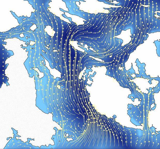
1 Ocean circulation, sedimentation in the San Juans - compilation of mainstream scientific literature by Dave Hyde - Salish Sea has 3 principal estuaries SG, JDF,PS San Juan Islands ocean setting uniquely at the cross roads & not part of the Puget Sound Tides, currents, river outflows & bottom water mixing overwhelm local runoff Water quality, sediments & local impacts issues? Decadal trends regional warming, sea level rise, precipitation? This body of scientific literature not yet incorporated into the BAS for the San Juan Cty CAO & SMP
2 Bottom Line Assessment -Directly Derived from Ocean Model Studies- SJC is 98% in the path of a massive SSG circulation system - mixing Pacific seawater, fresh water outflow & effluent of a population exceeding 3.65 million people No measure taken by SJC to mitigate perceived local runoff problems on a general scale will have any effect on marine shoreline water quality Only the Canadians can fix general water quality issues within our coastal waters No local water quality measurement or monitoring effort will produce meaningful information - we are overwhelmed daily by circulating Canadian water No local-scale cause and effect relationship can be established Nothing that is going on in the Puget Sound affects SJC, or is affected by SJC environmental measures Any studies/advice linking Puget Sound issues with SJC are totally inaccurate SJC environmental initiatives for its coastal zones can only make a difference on the few local issues it has -- generally localized upper bays with reduced flushing Considering the mature & tested oceanographic science connecting San Juan Archipelago coastal waters to Canadian circulation, there can be no measurable change to overall SJC water quality from the current CAO or SMP initiatives a focus on spot issues would instead be productive

3 Literature Search Questions What is the connection of SJC marine waters to Puget Sound watershed water quality issues & mitigation initiatives: Ocean circulation connection or just political? What is the current state of Physical Oceanography of SJC waters & relationship to County CAO/SMP initiatives: What is the big picture Can an environmental baseline be established? Can shoreline waters impacts be quantified or measured? Are there specific shorelines where County actions might make a difference?

4 Strait of JDF San Juan Islands

5 SSG & SJA ocean geochemistry cycle

6 Estuarine mixing in the JDF? -Very little! - Puget Sound & Strait of Georgia flows keep to their sides of the highway 12/18/2011 tides Flood IOS interactive tidal model Ebb
7 High energy tides & northern river outflows dominate local circulation! IOS interactive tidal model 9 hour time series, 03/26/ hrs
8

9 Vertical mixing in the Haro Strait

10 Boundary Pass Flows 12/18/2011

11 Fresh water Flows into the SSG - Dominates SJA spring/summer circulation & sedimentation - Fraser river & other BC rivers produced ~ 220 cu km FW in 2011, 6-8x PS sources ~ 25% of SG total volume kt avg flow out through SJA into JDF Surface plume in SSG mixed by tidal action at Boundary pass sill & Haro Strait 30 million metric tons of annual particulate outflow 2/3 in suspended fine sediments Local mixing enables bottom water north flow from JDF into SSG Fine sediments deposited in the SJA bays by complex process
12 Stream flow & nutrients from yr2000 WWU SJA survey - Negligible discharge relative to Fraser river -Negligible nutrient discharge relative to bottom water supply


13 Satellite mapping of suspended sediments & chlorophyll

14 Sediment suspension and remixing in SJC channels Data from IOS Johannnessen et al 2006

15 Tidal mixing of Fraser SSG plumes & Island sediments Sills with strong tidal flows Mix sediments throughout water column & scour bottom areas Create sediment deposition fields Boundary Pass sill has created the largest known active seabed Dune field Data from MLML/IOS 2002 bottom imaging sonar survey Same instruments as used in modern hydrographic surveys

16


17 What do these seabed maps tell us? -Tides are remixing bottom sediments -Sediments are settling in quieter waters -SJA harbors & bays have a constant influx of sediments via tidal exchange with channels -Plume influx persists from April thru August -Remixing spans all seasons (spring tides) Sediment Geology from core samples


18 Regional long term trends (decadal, not climate change) - local ocean temperature (~0.15 deg C/decade)
19 Summary Findings and Conclusions Local tides create turbulent mixing throughout the Islands shoreline marine zones that constantly bring up bottom water (hence the low temps) This is a good thing, the salty bottom water is the really clean stuff SJC has the best flushed coastal waters in the lower 48 states Rivaled only by the north Maine coast Several local partial exceptions Northern reaches of Orcas East and West Sounds (runoff & reduced flushing) Friday Harbor (high density urban runoff, excellent flushing in harbor, periodic chlorination of WWTP effluent) Above issues aside, SJC coastal zone runoff to the ocean is very rapidly transported out the JDF to the Pacific Ocean This is scientific fact, not a call for less than responsible coastal water management in the San Juan Islands These facts do not support the imposition of extraordinary restrictions buffer zone extensions as proposed in the current CAO & SMP development
20 What can you take away from this Summary? SJA sits in a unique marine setting of high energy tidal flows exchanging JDF bottom waters & seasonal fresh water plumes from the SSG IOS locally provides a world class resource for tidal flow modeling & oceanography Local Sills & Spring tides create wide spread turbulence that mix marine flows & bottom water Neap tides refresh bottom waters from JDF & renew nutrients year-round Natural bottom water nutrients dominate locally, not runoff or even Fraser outflow Renewal time of waters in SJA marine straits & channels is short ~ 1-2 days Most bays & harbors exchange high % volume with channels daily Spring/summer influx from Fraser plumes dominate SJA sedimentation On a multi-decadal trend line SJA & SSG waters are warming slowly Warming rate modulated by PDO predominantly & somewhat by Fraser outflow temps Precipitation increase of 10-25% predicted multi-decadal Fresh water SSG outflows will increase & distribute more evenly over seasons Compelling and extensive scientific literature is available to set a baseline for SJ Islands environmental updates (CAO & SMP)
21 A Selected Bibliography 1. A Model Study of the Salish Sea Estuarine Circulation Sutherland & MacCready (Univ of Wash), Banas (APL UW), Smestead ( NRL) June 2011, DOI: /2011, JPO Observations and modeling of seasonal variability in the Strait of Georgia and Juan de Fuca Masson & Cummins (IOS - Sidney, BC) Journal of Marine Research 62, , The Circulation & Residence Time of Strait of Georgia using a Simple Mixing-Box Approach Pawlowicz, Riche & Halverson (Dept of Earth & Ocean Sciences, UBC Atmosphere-Ocean 45 (4) 2007, , Canadian Meteorological & Oceanographic Society 4. Comparative analysis of Canadian Pacific North Coast & Strait of Georgia marine ecosystems Perry, Crawford, & Sinclair (Fisheries & Oceans Canada) PICES 16 th Annual Meeting, Victoria, 26 October Fraser River Basin Case Study, British Columbia, Canada Calbick, MacAllister, Marshall & Like for the Fraser Basin Council, Dec. 2004
Future climate impacts on Puget Sound oceanography: the North Pacific and hydrological context
 Western Washington University Western CEDAR Salish Sea Ecosystem Conference 2014 Salish Sea Ecosystem Conference (Seattle, Wash.) Apr 30th, 1:30 PM - 3:00 PM Future climate impacts on Puget Sound oceanography:
THE BC SHELF ROMS MODEL
 THE BC SHELF ROMS MODEL Diane Masson & Isaac Fine, Institute of Ocean Sciences The Canadian west coast perspective (filling the gap ) AVISO, Eddy Kinetic Energy (cm 2 s -2 ) In this talk Model set-up and
Present and Future Upwelling off the Entrance to Juan de Fuca Strait
 Present and Future Upwelling off the Entrance to Juan de Fuca Strait Mike Foreman 1, Wendy Callendar 12, Amy MacFadyen 3, Barbara Hickey 3, Bill Merryfield 4, Badal Pal 4, Richard Thomson 1, Emanuele Di
The Blob, El Niño, and the Drought in Puget Sound
 The Blob, El Niño, and the Drought in Puget Sound Christopher Krembs, Marine Monitoring Unit, EAP, Ecology The Drought The Blob El Niño Warmest first four months since 1981, (Source: NASA's Goddard Institute
Why the Strait of Georgia is not a Dead Zone. Sophie Johannessen, Diane Masson and Rob Macdonald DFO Institute of Ocean Sciences, Sidney, B.C.
 Why the Strait of Georgia is not a Dead Zone Sophie Johannessen, Diane Masson and Rob Macdonald DFO Institute of Ocean Sciences, Sidney, B.C. Google Earth has awarded the Strait of Georgia a dead fish.
WIND EFFECTS ON CHEMICAL SPILL IN ST ANDREW BAY SYSTEM
 WIND EFFECTS ON CHEMICAL SPILL IN ST ANDREW BAY SYSTEM PETER C. CHU, PATRICE PAULY Naval Postgraduate School, Monterey, CA93943 STEVEN D. HAEGER Naval Oceanographic Office, Stennis Space Center MATHEW
Modeling the Transport and Fate of Sediments Released from Dredging Projects in the Coastal Waters of British Columbia, Canada
 WEDA Dredging Summit & Expo 18 Modeling the Transport and Fate of Sediments Released from Dredging Projects in the Coastal Waters of British Columbia, Canada David B. Fissel, Yuehua (Andy) Lin and Todd
Regional Ocean Climate Model Projections for the British Columbia Continental Shelf
 Regional Ocean Climate Model Projections for the British Columbia Continental Shelf Mike Foreman, Wendy Callendar, John Morrison, Diane Masson, Isaac Fine Institute of Ocean Sciences Fisheries and Oceans
STRATOGEM The Strait of Georgia Ecosystem Project
 STRATOGEM The Strait of Georgia Ecosystem Project R. Pawlowicz 1 S. Allen 1, J. Dower 2, R. Lee 1, S. Harris 1, M. Halverson 1, O. Riche 1 and T. Bird 2 1 Deptartment of Earth and Ocean Sciences, University
A Comparison of Predicted Along-channel Eulerian Flows at Cross- Channel Transects from an EFDC-based Model to ADCP Data in South Puget Sound
 A Comparison of Predicted Along-channel Eulerian Flows at Cross- Channel Transects from an EFDC-based Model to ADCP Data in South Puget Sound Skip Albertson, J. A. Newton and N. Larson Washington State
Science 8 - Water Systems Test - Chapters 1-2
 Science 8 - Water Systems Test - Chapters 1-2 Multiple Choice (30 marks) Identify the choice that best completes the statement or answers the question. 1. What percentage represents the amount of fresh
Modeling the Columbia River Plume on the Oregon Shelf during Summer Upwelling. 2 Model
 Modeling the Columbia River Plume on the Oregon Shelf during Summer Upwelling D. P. Fulton August 15, 2007 Abstract The effects of the Columbia River plume on circulation on the Oregon shelf are analyzed
Characterizing the Physical Oceanography of Coastal Waters Off Rhode Island
 Characterizing the Physical Oceanography of Coastal Waters Off Rhode Island Dan Codiga and Dave Ullman Graduate School of Oceanography University of Rhode Island RI OSAMP Stakeholder Meeting January 5,
SECTION 2 How Is Pacific Northwest Climate Changing?
 SECTION 2 How Is Pacific Northwest Climate Changing? The Pacific Northwest is experiencing a suite of long-term changes that are consistent with those observed globally as a result of human-caused climate
Coastal Oceanography. Coastal Oceanography. Coastal Waters
 Coastal Oceanography Coastal Oceanography 95% of ocean life is in coastal waters (320 km from shore) Estuaries and wetlands are among most productive ecosystems on Earth Major shipping routes, oil and
8.1 SPATIAL VARIABILITY OF TIDAL CURRENTS IN PUGET SOUND, WASHINGTON. Gregory Dusek, Christina Pico, Christopher Paternostro and Paul Fanelli,
 Presented at the 96 th AMS Annual Meeting, New Orleans, LA, January 10-14, 2016 8.1 SPATIAL VARIABILITY OF TIDAL CURRENTS IN PUGET SOUND, WASHINGTON Gregory Dusek, Christina Pico, Christopher Paternostro
Three-Dimensional Numerical Modeling of Sediment Transport For Coastal Engineering Projects in British Columbia, Canada
 Three-Dimensional Numerical Modeling of Sediment Transport For Coastal Engineering Projects in British Columbia, Canada David B. Fissel ASL Environmental Sciences Inc. Victoria, BC, V8M 1Z5, Canada, dfissel@aslenv.com
Resume components. Assignments due Monday. Shape of Puget Sound. Formation and bathymetry
 Assignments due Monday Resume Top four choices of projects, in order of preference One paragraph proposal about topic of choice Weekly schedule Topics you d like to cover in class Math: Complete the calculus
Catherine Cougan 1. Pelagic Ecosystem Function Apprenticeship 1 Friday Harbor Laboratories, University of Washington, Friday Harbor, WA, 98250
 Factors affecting San Juan Channel and Puget Sound water properties during fall 2014 Catherine Cougan 1 Pelagic Ecosystem Function Apprenticeship 1 Friday Harbor Laboratories, University of Washington,
Operational Modelling of Southwest British Columbia Waters Using the Princeton Ocean Model
 Operational Modelling of Southwest British Columbia Waters Using the Princeton Ocean Model Scott W. Tinis and Richard E. Thomson Institute of Ocean Sciences 9860 West Saanich Road P.O. Box 6000 Sidney,
How typical are current conditions?
 How typical are current conditions? NANOOS provides many sources of information for those wanting to track oceanographic conditions throughout the NE Pacific Ocean to be able to understand if the current
Hypoxia in the Northern Gulf of Mexico in 2010: was the Deepwater Horizon Oil Spill a Factor? Nathaniel E. Ostrom
 Agricultural Outlook Forum Presented: February 24-25, 2011 U.S. Department of Agriculture Hypoxia in the Northern Gulf of Mexico in 2010: was the Deepwater Horizon Oil Spill a Factor? Nathaniel E. Ostrom
Oceanography Quiz 2. Multiple Choice Identify the choice that best completes the statement or answers the question.
 Oceanography Quiz 2 Multiple Choice Identify the choice that best completes the statement or answers the question. 1. The highest and lowest tides are known as the spring tides. When do these occur? a.
The surface of the ocean floor is as varied as the land. The five major oceans, from largest to smallest, are
 11.1 Ocean Basins The surface of the ocean floor is as varied as the land. The five major oceans, from largest to smallest, are w the Pacific w the Atlantic w the Indian w the Southern w the Arctic The
Semi-enclosed seas. Estuaries are only a particular type of semi-enclosed seas which are influenced by tides and rivers
 Semi-enclosed seas Estuaries are only a particular type of semi-enclosed seas which are influenced by tides and rivers Other semi-enclosed seas vary from each other, mostly by topography: Separated from
Linking Sediment Transport in the Hudson from the Tidal River to the Estuary
 Linking Sediment Transport in the Hudson from the Tidal River to the Estuary Or, what happened to all the mud from Irene? David Ralston, Rocky Geyer, John Warner, Gary Wall Hudson River Foundation seminar
Section 2.1 Ocean Basins. - Has helped determine where ocean basins are located. - Tectonic plates move changing the position of the continents.
 Science 8 Unit 1: Water Systems on Earth Chapter 2: Oceans Control the Water Cycle Section 2.1 Ocean Basins Oceans are important because: 1. Primary water source for the water cycle 2. Control weather
Physical Oceanography
 Physical Oceanography SECTION 15.1 The Oceans In your textbook, read about modern oceanography. For each item in Column A, write the letter of the matching item in Column B. Column A 1. German research
Developed in Consultation with Florida Educators
 Developed in Consultation with Florida Educators Table of Contents Next Generation Sunshine State Standards Correlation Chart... 7 Benchmarks Chapter 1 The Practice of Science...................... 11
Mid-season Storm Surge Update: December, 2013
 December 17, 2012 Ambleside Beach (Photograph by: Mark van Manen, PNG) Mid-season Storm Surge Update: December, 2013 Mid-season discussion of tidal and climate conditions affecting extreme water levels
Assessing the Site Potential for Underwater Turbines in Tidal Channels Using Numerical Modeling and Advanced Ocean Current Measurements
 Assessing the Site Potential for Underwater Turbines in Tidal Channels Using Numerical Modeling and Advanced Ocean Current Measurements David B. Fissel, Jianhua Jiang, Rick Birch, Jan Buermans and David
Lu, S., P. Craig, C. Wallen, Z. Liu, A. Stoddard, W. McAnnally and E. Maak. Dynamic Solutions, Knoxville, TN USACOE, Sacramento District
 An Extended-Delta Hydrodynamic Model Framework for Sea Level Rise Analysis to Support Resource Management Planning for the Sacramento-San Joaquin River Delta Lu, S., P. Craig, C. Wallen, Z. Liu, A. Stoddard,
Where is all the water?
 Where is all the water? The distribution of water at the Earth's surface % of total Oceans 97.25 Ice caps and glaciers 2.05 Groundwater 0.68 Lakes 0.01 Soils 0.005 Atmosphere (as vapour) 0.001 Rivers 0.0001
The Coast: Beaches and Shoreline Processes
 1 2 3 4 5 6 7 8 9 The Coast: es and Shoreline Processes Trujillo & Thurman, Chapter 10 Oceanography 101 Chapter Objectives Recognize the various landforms characteristic of beaches and coastal regions.
Supplemental Slides. Shore: Junction of Land & Water. Junction of Land & Water. Sea Level Variations. Shore vs. Coast. Sea Level Variations
 Shore: Junction of Land & Water Supplemental Slides Sediments come off land Most get dumped at the beach Sediment interacts with ocean waves and currents Junction of Land & Water Features: Breaking waves,
Shore: Junction of Land & Water. Sediments come off land Most get dumped at the beach Sediment interacts with ocean waves and currents
 Shore: Junction of Land & Water Supplemental Slides Sediments come off land Most get dumped at the beach Sediment interacts with ocean waves and currents Junction of Land & Water Features: Breaking waves,
Applications of 3D Coastal Circulation Numerical Model in Assessing Potential locations of Installing Underwater Turbines 1
 Applications of 3D Coastal Circulation Numerical Model in Assessing Potential locations of Installing Underwater Turbines 1 Jianhua Jiang, David B. Fissel 1 Abstract The three-dimensional, coastal circulation
The Coast: Beaches and Shoreline Processes Trujillo & Thurman, Chapter 10
 The Coast: es and Shoreline Processes Trujillo & Thurman, Chapter 10 Oceanography 101 Chapter Objectives Recognize the various landforms characteristic of beaches and coastal regions. Identify seasonal
Appendix G.18 Hatch Report Pacific NorthWest LNG Lelu Island LNG Potential Impacts of the Marine Structures on the Hydrodynamics and Sedimentation
 Appendix G.18 Hatch Report Pacific NorthWest LNG Lelu Island LNG Potential Impacts of the Marine Structures on the Hydrodynamics and Sedimentation Patterns Project Memo H345670 To: Capt. David Kyle From:
Oceanography. Oceanography is the study of the deep sea and shallow coastal oceans.
 Oceanography Oceanography is the study of the deep sea and shallow coastal oceans. Studying the Ocean Floor To determine the shape and composition of the ocean floor, scientists use techniques such as
Physical Oceanography
 Physical Oceanography SECTION 15.1 The Oceans In your textbook, read about modern oceanography. For each item in Column A, write the letter of the matching item in Column B. e b c d a Column A 1. German
Introducing IMS. v) Select the Zoom to Full Extent tool. Did you return to the original view?
 Select the Zoom to Full Extent tool. Did you return to the original view?") Ocean/ENVIR 260, Winter 2006 Lab 1, Get to Know the Puget Sound Watershed Name Introducing IMS 1) Open your web browser and navigate to http://128.208.23.127/website/lab1. (This link can be found on the
Ocean/ENVIR 260, Winter 2006 Lab 1, Get to Know the Puget Sound Watershed Name Introducing IMS 1) Open your web browser and navigate to http://128.208.23.127/website/lab1. (This link can be found on the
Understanding Oceans, Gulfs & Tides
 SCS-2005-13 Water and Me Series Understanding s, Gulfs & Tides Monty C. Dozier Assistant Professor and Extension Water Resources Specialist The dictionary defines the ocean as the whole body of saltwater
Signals of sea-level rise in Delaware and Chesapeake Bay tides
 Signals of sea-level rise in Delaware and Chesapeake Bay tides Andrew C. Ross and Raymond G. Najjar Pennsylvania State University Also thanks to Ming Li, Serena Lee, Fan Zhang, Wei Liu Observations show
A case for FLH in coastal waters: monitoring the spring bloom in British Columbia, Canada, plus MCI examples
 A case for FLH in coastal waters: monitoring the spring bloom in British Columbia, Canada, plus MCI examples Jim Gower, Stephanie King, Institute of Ocean Sciences, Fisheries and Oceans Canada, Sidney
The Delaware Environmental Monitoring & Analysis Center
 The Delaware Environmental Monitoring & Analysis Center Tina Callahan Delaware Estuary Science & Environmental Summit 2013 January 27-30, 2013 What is DEMAC? Delaware Environmental Monitoring & Analysis
A Comparison of the Anomalous Ocean Conditions observed off the West Coast of Canada in 2014 and 2015.
 A Comparison of the Anomalous Ocean Conditions observed off the West Coast of Canada in 2014 and 2015. Peter Chandler, Marie Robert, Moira Galbraith Institute of Ocean Sciences, Fisheries and Oceans Canada,
Estimating the Mean Temperature and Salinity of the Chesapeake Bay Mouth
 Estuaries Vol. 25, No. 1, p. 1 5 February 2002 Estimating the Mean Temperature and Salinity of the Chesapeake Bay Mouth RICARDO A. LOCARNINI,LARRY P. ATKINSON*, and ARNOLDO VALLE-LEVINSON Center for Coastal
Fortnightly modulation of the estuarine circulation in Juan de Fuca Strait
 Journal of Marine Research, 58, 439 463, 2000 Fortnightly modulation of the estuarine circulation in Juan de Fuca Strait by Diane Masson 1 and Patrick F. Cummins 1 ABSTRACT Riverine discharge into the
2015: A YEAR IN REVIEW F.S. ANSLOW
 2015: A YEAR IN REVIEW F.S. ANSLOW 1 INTRODUCTION Recently, three of the major centres for global climate monitoring determined with high confidence that 2015 was the warmest year on record, globally.
Grade 8 Science. Unit 1: Water Systems on Earth Chapter 2
 Grade 8 Science Unit 1: Water Systems on Earth Chapter 2 Oceans are important... 1. Primary water source for the water cycle 2. Control weather 3. Support diverse life 4. Provides humans with food, minerals,
Ice and Ocean Mooring Data Statistics from Barrow Strait, the Central Section of the NW Passage in the Canadian Arctic Archipelago
 Ice and Ocean Mooring Data Statistics from Barrow Strait, the Central Section of the NW Passage in the Canadian Arctic Archipelago Simon Prinsenberg and Roger Pettipas Bedford Institute of Oceanography,
Jianhua Jiang 1, David B. Fissel 1 and Keath Borg 1. Presented at ECM
 Sediment Plume and Deposition Modeling of Removal and Installation of Underwater Electrical Cables on Roberts Bank, Strait of Georgia, British Columbia, Canada Jianhua Jiang 1, David B. Fissel 1 and Keath
River Response. Sediment Water Wood. Confinement. Bank material. Channel morphology. Valley slope. Riparian vegetation.
 River Response River Response Sediment Water Wood Confinement Valley slope Channel morphology Bank material Flow obstructions Riparian vegetation climate catchment vegetation hydrological regime channel
The Water Planet Ch. 22
 The Water Planet Ch. 22 What is Oceanography? the study of the Earth s oceans using chemistry, biology, geology, and physics. Oceans cover 70% of the Earth s surface Ocean Research 22.1 The use of submarines
APPENDIX O. Sediment Modeling of Dredging off Lelu Island, Prince Rupert, BC Canada, and Disposal of Dredgate at Brown Passage
 APPENDIX O Sediment Modeling of Dredging off Lelu Island, Prince Rupert, BC Canada, and Disposal of Dredgate at Brown Passage Sediment Modeling of Dredging off Lelu Island, Prince Rupert, BC Canada, and
Salinity Gradients in the Mission-Aransas National Estuarine Research Reserve. Kimberly Bittler GIS and Water Resources Fall 2011
 Salinity Gradients in the Mission-Aransas National Estuarine Research Reserve Kimberly Bittler GIS and Water Resources Fall 2011 INTRODUCTION Freshwater inflow has a widely recognized influence on estuary
IMPACTS OF MARINE ENERGY ON COASTAL SEDIMENTATION B) TIDAL POWER C) COASTAL SEDIMENTS D) GRAND CHALLENGES
 TIDAL POWER C) COASTAL SEDIMENTS D) GRAND CHALLENGES") IMPACTS OF MARINE ENERGY ON COASTAL SEDIMENTATION DAVID PRANDLE A) MARINE ENERGY PRACTICALITIES? B) TIDAL POWER C) COASTAL SEDIMENTS D) GRAND CHALLENGES MARINE ENERGY PRACTICALITIES? PARAMETER THEORY LA
IMPACTS OF MARINE ENERGY ON COASTAL SEDIMENTATION DAVID PRANDLE A) MARINE ENERGY PRACTICALITIES? B) TIDAL POWER C) COASTAL SEDIMENTS D) GRAND CHALLENGES MARINE ENERGY PRACTICALITIES? PARAMETER THEORY LA
Predicting tsunami waves and currents on the West Coast of Canada: A case study for Ucluelet, BC
 Predicting tsunami waves and currents on the West Coast of Canada: A case study for Ucluelet, BC Josef Cherniawsky, Kelin Wang and Roy Walters Institute of Ocean Sciences, Fisheries & Oceans Canada Pacific
APPENDIX 6.5-B Knight Piésold Kitsault Mine Climate Change Assessment Letter KITSAULT MINE PROJECT ENVIRONMENTAL ASSESSMENT APPENDICES
 ENVIRONMENTAL ASSESSMENT APPENDICES APPENDIX 6.5-B Knight Piésold Kitsault Mine Climate Change Assessment Letter VE51988 Appendices File No.:VA11-343/9-A.1 Cont. No.:VA11-175 Suite 14-75 West Pender Street
Community Mapping Network. Selected Coastal Atlases and Information Systems in British Columbia, Canada
 Community Mapping Network Selected Coastal Atlases and Information Systems in British Columbia, Canada Outline Community Mapping Network cmnbc.ca Pacific Coastal Resources Atlas for BC cmnbc.ca The Living
Tidal Energy Dissipation at the Sill of Sechelt Inlet, British Columbia
 VOLUME 31 JOURNAL OF PHYSICAL OCEANOGRAPHY DECEMBER 001 Tidal Energy Dissipation at the Sill of Sechelt Inlet, British Columbia SCOTT W. TINIS* AND STEPHEN POND Department of Earth and Ocean Sciences,
Fire Season Prediction for Canada, Kerry Anderson Canadian Forest Service
 Fire Season Prediction for Canada, 2014 Kerry Anderson Canadian Forest Service 1 Introduction The Canadian Forest Service is now presenting monthly and seasonal forecast maps through the Canadian Wildland
New Zealand Climate Update No 223, January 2018 Current climate December 2017
 New Zealand Climate Update No 223, January 2018 Current climate December 2017 December 2017 was characterised by higher than normal sea level pressure over New Zealand and the surrounding seas. This pressure
Session: For more information:
 Session: For more information: www.hydropower.org/congress Sediment management: mitigation options? Marc Goichot World Hydropower Congress Beijing, China 21 May 2015 A project jointly implemented by MRCS
The near-bottom current regime and the role of the benthic. nepheloid layer in transport and accumulation of particulate matter
 The near-bottom current regime and the role of the benthic nepheloid layer in transport and accumulation of particulate matter in Puget Sound, Washington Shannon K. Maynor University of Washington School
Presentation Outline. Project Overview. Sea Level Rise Assessment & Decision Tools. Community Engagement. Tina Whitman, Friends of the San Juans
 Healthy Beaches for People & Fish Sea Level Rise Adaptation Tools for San Juan County, WA Tina Whitman & Andrea MacLennan December 10, 2015 Presentation Outline Project Overview Tina Whitman, Friends of
A cross channel survey of southern Rosario Strait, Puget Sound, Washington during a flood tide using ADCP/CTD methods
 A cross channel survey of southern Rosario Strait, Puget Sound, Washington during a flood tide using ADCP/CTD methods Chet Harrison University of Washington School of Oceanography, PO Box 357940 Seattle,
Changing Marine Access in the Arctic Ocean: The Arctic Climate Impact Assessment Panama Canal Authority 11 January 2005
 Changing Marine Access in the Arctic Ocean: The Arctic Climate Impact Assessment Panama Canal Authority 11 January 2005 Lawson Brigham Deputy Director, U.S. Arctic Research Commission ACIA Contributing
Appendix G.19 Hatch Report Pacific NorthWest LNG Lelu Island LNG Maintenance Dredging at the Materials Offloading Facility
 Appendix G.19 Hatch Report Pacific NorthWest LNG Lelu Island LNG Maintenance Dredging at the Materials Offloading Facility Project Memo H345670 To: Capt. David Kyle From: O. Sayao/L. Absalonsen December
Time-series observations in the Northern Indian Ocean V.V.S.S. Sarma National Institute of Oceanography Visakhapatnam, India
 The Second GEOSS Asia-Pacific Symposium, Tokyo, 14-16 th April 28 Time-series observations in the Northern Indian Ocean V.V.S.S. Sarma National Institute of Oceanography Visakhapatnam, India Seasonal variations
THE CANADIAN CENTRE FOR CLIMATE MODELLING AND ANALYSIS
 THE CANADIAN CENTRE FOR CLIMATE MODELLING AND ANALYSIS As Canada s climate changes, and weather patterns shift, Canadian climate models provide guidance in an uncertain future. CANADA S CLIMATE IS CHANGING
A Report on a Statistical Model to Forecast Seasonal Inflows to Cowichan Lake
 A Report on a Statistical Model to Forecast Seasonal Inflows to Cowichan Lake Prepared by: Allan Chapman, MSc, PGeo Hydrologist, Chapman Geoscience Ltd., and Former Head, BC River Forecast Centre Victoria
Microplastics in the marine environment of coastal British Columbia
 Microplastics in the marine environment of coastal British Columbia Jean-Pierre Desforges 1, Moira Galbraith 2, Neil Dangerfield 2, Peter Ross 1 1 School of Earth and Ocean Sciences, University of Victoria,
It s true, these activities are all facets of marine science. But they represent a pretty small part of the picture.
 Welcome. Thanks for coming to CBNERR s Discovery Lab. I m Lisa Lawrence and I m a marine educator at VIMS. Tonight, I m going to give you just glimpse of what it s like to be a marine scientist and tell
MEMORANDUM FOR SWG
 MEMORANDUM FOR SWG-2007-1623 Subject: Jurisdictional Determination (JD) for SWG-2007-1623 on Interdunal Wetlands Adjacent to Traditional Navigable Waters (TNWs) Summary The U.S. Environmental Protection
Climate Variability. Eric Salathé. Climate Impacts Group & Department of Atmospheric Sciences University of Washington. Thanks to Nathan Mantua
 Climate Variability Eric Salathé Climate Impacts Group & Department of Atmospheric Sciences University of Washington Thanks to Nathan Mantua Northwest Climate: the mean Factors that influence local/regional
Ocean facts continued
 Ocean Facts A dynamic system in which many chemical and physical changes take place Formed over millions of years as precipitation filled low areas on Earth called basins and now covers 70% of the Earth
Applying Basin-Scale HyCOM Hindcasts in Providing Open Boundary Conditions for Nested High-Resolution Coastal Circulation Modeling
 Applying Basin-Scale HyCOM Hindcasts in Providing Open Boundary Conditions for Nested High-Resolution Coastal Circulation Modeling Ruoying He Woods Hole Oceanographic Institution December 7, 2005 Cape
HAIDA GWAII CLIMATE ASSESSMENT 2010 Special Report for MIEDS Franc Pridoehl
 HAIDA GWAII CLIMATE ASSESSMENT 2010 Special Report for MIEDS Franc Pridoehl INTRODUCTION Climatic conditions have varied considerably on Haida Gwaii over the past centuries and millennia (Hebda 2007).
Oceanography II Notes
 Oceanography II Notes Tides The rise and fall in sea level is called a tide. Caused by a giant wave and the gravitational pull of the moon and sun on the ocean One low-tide/high-tide cycle takes about
3. Climate Change. 3.1 Observations 3.2 Theory of Climate Change 3.3 Climate Change Prediction 3.4 The IPCC Process
 3. Climate Change 3.1 Observations 3.2 Theory of Climate Change 3.3 Climate Change Prediction 3.4 The IPCC Process 3.1 Observations Need to consider: Instrumental climate record of the last century or
Geol 117 Lecture 18 Beaches & Coastlines. I. Types of Coastlines A. Definition:
 I. Types of Coastlines A. Definition: 1. Shore = narrow zone where ocean meets land (e.g. beach) 2. Coast is a broad area where both ocean and land processes act a. Includes onshore marshes, dunes, sea
5. MANY COASTAL COMMUNITIES AND FACILITIES WILL FACE INCREASING EXPOSURE TO STORMS.
 5. MANY COASTAL COMMUNITIES AND FACILITIES WILL FACE INCREASING EXPOSURE TO STORMS. Climate change is altering the Arctic coastline and much greater changes are projected for the future as a result of
Lecture 1. Amplitude of the seasonal cycle in temperature
 Lecture 6 Lecture 1 Ocean circulation Forcing and large-scale features Amplitude of the seasonal cycle in temperature 1 Atmosphere and ocean heat transport Trenberth and Caron (2001) False-colour satellite
The Ocean Floor THE VAST WORLD OCEAN
 OCEANOGRAPHY Name Color all water LIGHT BLUE. Color all land LIGHT GREEN. Label the 5 Oceans: Pacific, Atlantic, Indian, Arctic, Antarctic. Label the 7 Continents: N.America, S.America, Europe, Asia, Africa,
North Pacific Climate Overview N. Bond (UW/JISAO), J. Overland (NOAA/PMEL) Contact: Last updated: September 2008
, J. Overland (NOAA/PMEL) Contact: Last updated: September 2008") North Pacific Climate Overview N. Bond (UW/JISAO), J. Overland (NOAA/PMEL) Contact: Nicholas.Bond@noaa.gov Last updated: September 2008 Summary. The North Pacific atmosphere-ocean system from fall 2007
North Pacific Climate Overview N. Bond (UW/JISAO), J. Overland (NOAA/PMEL) Contact: Nicholas.Bond@noaa.gov Last updated: September 2008 Summary. The North Pacific atmosphere-ocean system from fall 2007
2. Can you describe how temperature and dissolved solids changes the density of water?
 Unit 4: Oceanography LT 4.1 Density: I can explain the role density plays to help form some currents. #1 Yes I can: 1. Can you explain what density is and how you calculate it? 2. Can you describe how
Waterways from glaciers to coastal waters in Iceland. Jórunn Harðardóttir, IMO Nordic WFD conference September 26, 2012
 Waterways from glaciers to coastal waters in Iceland Jórunn Harðardóttir, IMO Nordic WFD conference September 26, 2012 What to include and what not to include? Hydrology of Iceland Much on glaciers and
Sea Level Variations at Jeddah, Eastern Coast of the Red Sea
 JKAU: Mar. Sci., Vol. 21, No. 2, pp: 73-86 (21 A.D. / 1431 A.H.) DOI : 1.4197/Mar. 21-2.6 Sea Level Variations at Jeddah, Eastern Coast of the Red Sea Khalid M. Zubier Marine Physics Department, Faculty
Carbon Sequestration Potential from Coastal Wetlands Restoration Sites
 Carbon Sequestration Potential from Coastal Wetlands Restoration Sites Insert then choose Picture select your picture. Right click your picture and Send to back. Paul Krause, Alyssa Beach Emily Cooper,
1. Oceans. Example 2. oxygen.
 1. Oceans a) Basic facts: There are five oceans on earth, making up about 72% of the planet s surface and holding 97% of the hydrosphere. Oceans supply the planet with most of its oxygen, play a vital
HIGH RESOLUTION SEDIMENT DYNAMICS IN SALT-WEDGE ESTUARIES
 HIGH RESOLUTION SEDIMENT DYNAMICS IN SALT-WEDGE ESTUARIES Philip Orton, Dept. of Environmental Science and Engineering, Oregon Graduate Institute Douglas Wilson, Dept. of Environmental Science and Engineering,
California 120 Day Precipitation Outlook Issued Tom Dunklee Global Climate Center
 California 120 Day Precipitation Outlook Issued 11-01-2008 Tom Dunklee Global Climate Center This is my second updated outlook for precipitation patterns and amounts for the next 4 s of the current rainy
Tides. Tides are the slow, periodic vertical rise and fall of the ocean surface.
 PART 2 Tides Tides are the slow, periodic vertical rise and fall of the ocean surface. Tide is a giant wave caused by gravitational pull of the Moon and Sun on the rotating Earth. The gravitational pull
Natural U-Th series radio-nuclides reveal important estuarine biogeochemical processes in the Delaware and Chesapeake Bays, USA
 Presentation to the 10th IEBC Meeting Xiamen, CHINA, 21 May 2008 Natural U-Th series radio-nuclides reveal important estuarine biogeochemical processes in the Delaware and Chesapeake Bays, USA Thomas M.
PCB Aroclor Concentrations in Puget Sound Sediments
 PCB Aroclor Concentrations in Puget Sound Sediments Margaret Dutch, Sandra Aasen and Edward R. Long Washington State Department of Ecology Environmental Assessment Program [Editor s note: Tables and Figures
Main issues of Deltas
 Global sediment supply to coastal seas and oceans; location of major river deltas RIVER DELTAS Depositional processes - Course Coastal Morphodynamics GEO3-436; lecture 4 Nile Delta, Egypt Solo Delta, Java,
Oceans I Notes. Oceanography
 Oceans I Notes Outlines on the front table Oceanography the science of our oceans that mixes biology, geology, chemistry, and physics (among other sciences) to unravel the mysteries of our seas. Divisions
Investigating the contribution of allochthonous subsidies to kelp forests in central California
 Investigating the contribution of allochthonous subsidies to kelp forests in central California melissa m foley UCSC Institute of Marine Science and Center for Ocean Solutions system connectivity rivers