Aquarius/SAC-D Mission Overview Mónica Rabolli - Deputy PI Thirteenth Annual Meeting of the WCRP/CLIVAR/VAMOS Panel (VPM13) Bs. As.
|
|
|
- Lizbeth Atkinson
- 5 years ago
- Views:
Transcription

 Bs. As., julio 30 2010 1of 38")
1 Aquarius/SAC-D Mission Overview Mónica Rabolli - Deputy PI Thirteenth Annual Meeting of the WCRP/CLIVAR/VAMOS Panel (VPM13) Bs. As., julio of 38


2 Aquarius/SAC-D Observatory International Partnership between United States Argentina Aquarius Salinity Microwave Instrument Launch Vehicle Service Platform and SAC-D Science Instruments Mission Operations & Ground System 2of 38

3 Mission Overview 3of 38
")
4 Mission Objectives A Critical Climate Parameter Missing from the Present Satellite Observing Network Aquarius will yield an unprecedented view of ocean s role in climate and weather A Key to Studying the Global Hydrologic Cycle and Global Change Investigate the links between the global water cycle, ocean circulation and climate Make global, space-based measurements of Sea Surface Salinity (SSS) with high accuracy Observe and model seasonal and year-to-year variations of SSS, and how these relate to changes in the water cycle and ocean circulation Understanding the the Interactions Between the the Global Global Water Water Cycle, Cycle, Ocean Ocean Circulation and and Climate Through the the Measurement of of SSS SSS 4of 38


5 Mission Objectives SAC-D Science Mission is About Conducting Local Measurements Over Argentina Understanding ocean circulation, global water cycle and climate interaction Monitoring environmental changes, natural hazards and sea ice Monitoring atmospheric parameters Studying soil moisture Studying effect of cosmic radiation on electronic devices and characteristics of space debris Validate technology for future CONAE missions The The Aquarius/SAC-D Science Mission is is About About Conducting Local Local Measurements Over Over Argentina and and Contributing to to Global Global Investigations of of the the Atmosphere, the theoceans and and the theeffects of of Human and and Natural Processes on on the the Environment as as Defined in in the the Strategic Plan Plan of of the the Argentine National Space Space Program 5of 38


6 Relationship with Other Satellite Missions of CONAE SAC-C SAOCOM Aquarius/ SAC-D Instruments: MMRS, HRTC, HSTC, DCS GOLPE, MMP IST, INES ICARE Two L Band SAR Satellites. Transmission in H & V polarizations. Reception in Single, Dual & Polarimetric modes. Narrow, Wide and ScanSAR Swath modes. High, Medium and Low resolution modes. ( m) 6of 38

7 Relationship with Other Satellite Missions of NASA-ESA 7of 38


 CARMEN-1")

8 Instruments + S/P Observatory Aquarius/SAC-D Observatory Microwave Radiometer MWR Sun-synchronous orbit 6pm ascending node Satélite de Aplicaciones Científicas-D Service Platform SAC-D S/P New InfraRed Sensor Technology NIRST Revisit: 7 days Altitude 657 km High Sensitivity Camera HSC Launch: 2010 Mass: Mass: Kg Kg Power:1443 Power:1443 W Oper. Oper. Life: Life: 5 5 yrs yrs Aquarius (primary instrument) CARMEN-1 (ICARE-NG & SODAD) Radio Occultation Sounder for the Atmosphere ROSA Data Collection System DCS Technology Demonstration Package TDP 8of 38
9 Specific measurements Global sea surface salinity measurements (Aquarius). Retrieval of soil moisture (Aquarius). Measurements of precipitable water and sea surface wind speed (which will enhance the results of Aquarius measurements) (Microwave Radiometer-MWR). Measurements of water vapor, cloud liquid water and sea ice concentration (Microwave Radiometer-MWR). Monitoring of hot spots caused by biomass fires and volcanic eruptions, estimation of fire radiative power (NIRST). Measurements of sea surface temperature (NIRST). 9of 38
10 Specific measurements Measurements of light intensity (urban areas, detection of electric storms, snow coverage, detection of fishing boats and aurora studies) (HSC). Measurements of atmospheric temperature, pressure profiles, and water vapor content (ROSA). Measure the high energy radiation environment (ICARE). Measure the size distribution of micro- particles and space debris (SODAD). Collect environmental measured parameters (e.g. meteorological) (DCS) 10 of 38
11 SAC-D Instruments Several geophysical parameters are derived by measuring Tb at different bands SALINITY WIND SPEED LIQUID CLOUDS + WATER VAPOUR ΔTb Δ Pi Frequency (GHz) _ SEA SURFACE TEMPERATURE 11 of 38

12 Aquarius Seattle-Pass.png 12 of 38

13 Aquarius 13 of 38

14 MWR: SCIENCE REQUIREMENTS Science key-requirements (L2) The MWR shall be operated in an orbit which is in agreement with the Aquarius Orbit The orbit was chosen to provide weekly global coverage measurements over the Earth The MWR shall be continuously operating and return ocean and land surface data. Power and Mass memory allocation was also took into account for a 100% operation over sea and land 14 of 38

15 MWR: SCIENCE REQUIREMENTS Science key-requirements (L2) The MWR has a multi-beam configuration in each frequency The MWR shall be pointed towards the shadow side of the orbit to reduce the solar reflection and be coincident with Aquarius beams Elapse time between MWR and Aquarius observations < 150 sec. The MWR incidence angles shall be between 52 o and 58 o x z 36.5 GHz 8-beam antenna provides a half power angle of 1.7º that produces a < 54 km acrosstrack footprints in our pointing conditions Requirements repercussion on the MWR physical configuration 15 of 38

16 Footprints MWR & Aquarius Footprint 36.5GHz Middle beam Aquarius Outer beam Aquarius Inner beam Aquarius Footprint 23.8GHz 16 of 38

17 Geometry: Aquarius-MWR-NIRST 17 of 38
")


18 MWR AMSU (Advanced Microwave Sounder Unit) Product NOAA Satellite Sea Ice Total Precipitable Water Cloud Liquid Water SSMI on DMSP - Surface Wind Speed 18 of 38

19 MWIR: 3.8 µm LWIR1: 10.8µm LWIR1: 11.8µm 19 of 38

20 NIRST Fields of View Accessible Swath FOV: 75.6 deg 182 Km Swath-Width FOV: 15.6 deg 1064 Km 26 Km (3.9 sec) 20 of 38


21 NIRST NIRST: High Temperatures Events (HTE) Fires in Paraná Delta-Fall 2008 From MODIS Data 21 of 38


22 NIRST Volcanoes: El Chaiten Eruption- Fall 2008 MODIS SAC-C 22 of 38


23 NIRST SST NIRST almost 1 minute long nadiral scan over the Malvinas-Brazil eddies 512 pixels 1140 pixels 400 km 182 km 23 of 38


24 HSC HSTC Fires Detection Urban Lights Buenos Aires Snow Coverage 24 of 38


25 HSC HSC: Surveillance (fishing boat). 25 of 38
26 DCS Data Collection System (DCS) 26 of 38


27 ROSA Radio Occultation Sounder for the Atmosphere Frequency bands: MHz MHz 27 of 38


28 CARMEN-1 ICARE/SODAD Computer simulation of space debris distribution Results from ICARE on SAC-C 28 of 38
29 Science Programe Status First Announcement of Opportunity (NASA & CONAE/MinCyT) in order to select an International Science Investigating Team for the Aquarius/SAC-D Observatory. 30 proposal selected in june th Aquarius/ SAC-D Science Meeting- October th Aquarius/ SAC-D Science Meeting- July of 38

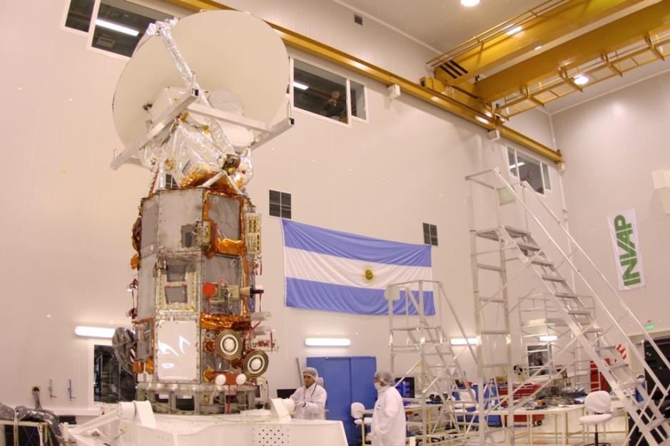

30 Observatory Flight Model I&T Aquarius Mechanical Integration 30 of 38


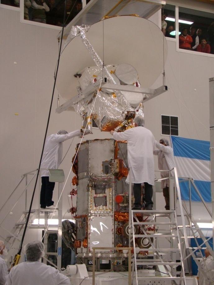
31 Observatory Flight Model I&T 31 of 38


32 Observatory Flight Model I&T 32 of 38


33 Thank you for your attention!! 33 of 38
34 Back-up slides 34 of 38


35 Some pictures: Front-end & Back-end Now the environmental tests are in progress 35 of 38
36 Aquarius SAC-D Instruments Overview INSTRUMENT OBJECTIVES SPECIFICATIONS RESOLUTION AGENCY Aquarius Understanding ocean circulation, Integrated L- Band radiometer Three beams:76 x 94, NASA global water cycle and (1.413 Ghz) and 84 x 120, 96 x 156 km climate interaction. Soil moisture scaterometer (1.26 Ghz) over Argentina swath: 390 km MWR Rain rate, winds speed, Bands: 23.8 Ghz V Pol. & Sixteen beams CONAE Microwave Radiometer sea ice concentration, 36.5 Ghz H and V Pol. < 54 km water vapour, cloud liquid water Band widht: 0.5 and 1 Ghz Swath: 380 km NIRST Hot spot events, Bands: 4, 11 y 12 um Space resolution: 350 m CONAE New Infrared Sensor Technology sea surface temperature Instantaneous swath 182 Km in temperature: 0.5 C CSA measurements extended swath 1000Km smallest burning detectable area Pointing: ± m² HSC Urban lights, electric storms, Pancromatic: nm meters CONAE High Sensitivity Camera polar regions, Swath: 700 Km snow cover DCS Data Collection System ROSA Radio Occultation Sounder for Atmosphere Data Collection System Mhz uplink 2 contacts per day CONAE with 200 platforms Atmospheric properties GPS Occultation Techniques Horiz: 300 Km Vert: 300m ASI CARMEN I Effects of cosmic radiation I: three Si detectors, I: 256 channels spectra CNES ICARE & SODAD in electronic devices, Si/Li S: Sensitivity: 0.5 u part. distribution of micro-particles S: four MOS sensors at 10Kkm/sec and space debris TDP Position, velocity and time GPS receiver Position: 20m, velocity:1m/sec CONAE Technological Demostration Package inertial angular velocity Inertial Unit Reference Angular Random Walk: determination deg/sqrt h 36 of 38
 Responsible for the")

 Responsible for the thermal analysis and the")
37 MWR: DEVELOPMENT TEAM 1. National Institute of Radioastronomy (IAR) Responsible for the radiometer receivers Collaborating with the Antennas tests & additional calculations 2. University of La Plata, Faculty of Engineering (UNLP), Department of Aeronautics (GEMA) Responsible for the thermal analysis and the structural design 3. Crux Responsible for the PDU and the Thermal Control Subsystem 37 of 38
38 MWR: SCIENCE REQUIREMENTS Mission key-requirements (L1) Microwave Radiometer (MWR) will measure the surface brightness temperature in the frequency range sensitive to geophysical parameters over the ocean such as water vapor, wind speed, rain rate, cloud liquid water and sea ice. Science key-requirements (L2) The 23.8 GHz channel (V polarization) The 36.5 GHz channel (H and V polarizations) The band widths: GHz & GHz The brightness temperature RMS error: 0.5 K The brightness temperature stability: 1 K 38 of 38
39 MWR: SCIENCE REQUIREMENTS Science key-requirements (L2) The MWR spatial resolution: 54 Km or less Same swath scene observation than Aquarius with an overlap of at least 95% Swath width shall be 380 km minimum Earth-projected Satellite path VELOCITY +X MWR & AQ swath Inclination 52º - 58º Look angle 48º d h = 657 km Azimuth 60º 16º 272 km 380 km d = 784 km 39 of 38


40 Some pictures: MWR Front-end Feed horn 40 of 38
41 Potential Users in Argentina Some Institutions... Universidades Nacionales Universidades Privadas Instituto Argentina de Oceanografía (IAO) INIDEP Secretarías de Pesca Provinciales Instituto Antártico CENPAT CADIC SHN SMN Servicio Meteorológico de la Armada Prefectura Argentina Plan Nacional de Manejo del Fuego Parques Nacionales SIFEM SENASA Latin-American Teams. 41 of 38

42 Mission Objectives The primary objective of this Joint Mission AQUARIUS/SAC-D is: To contribute to a better understanding of ocean circulation, the prediction of changes in this circulation, and its impact on Earth s climate and water cycle. 42 of 38
43 43 of 38
44 Mission Objectives Other important mission goal: To study the relationship between the different measurements performed by the observatory in the framework of: Oceanography Coastal Environment Climate Hydrology Natural Resources and Environmental Monitoring 44 of 38
45 Mission Objectives Continue... To provide information to help in the studies of the relationship between regional soil moisture and essential climate variables (ECV) on the appearance and spread of diseases as malaria, hantavirus, dengue, chagas. To study the relationship between measurements (as soil moisture and high temperature events) and natural hazards, as flooding and fires. Monitoring atmospheric parameters. Studying effect of cosmic radiation on electronic devices and characteristics of space debris. 45 of 38
Aquarius/SAC-D Observatory Mission Overview
 Aquarius/SAC-D Observatory Mission Overview Dr. Sandra Torrusio, SAC-D Principal Investigator-CONAE Oceanography Week April 12-16, 2010 Buenos Aires - Argentina Aquarius/SAC-D Observatory International
HY-2A Satellite User s Guide
 National Satellite Ocean Application Service 2013-5-16 Document Change Record Revision Date Changed Pages/Paragraphs Edit Description i Contents 1 Introduction to HY-2 Satellite... 1 2 HY-2 satellite data
Next generation of EUMETSAT microwave imagers and sounders: new opportunities for cloud and precipitation retrieval
 Next generation of EUMETSAT microwave imagers and sounders: new opportunities for cloud and precipitation retrieval Christophe Accadia, Sabatino Di Michele, Vinia Mattioli, Jörg Ackermann, Sreerekha Thonipparambil,
EUMETSAT STATUS AND PLANS
 1 EUM/TSS/VWG/15/826793 07/10/2015 EUMETSAT STATUS AND PLANS François Montagner, Marine Applications Manager, EUMETSAT WMO Polar Space Task Group 5 5-7 October 2015, DLR, Oberpfaffenhofen PSTG Strategic
RAIN RATE RETRIEVAL ALGORITHM FOR AQUARIUS/SAC-D MICROWAVE RADIOMETER. ROSA ANA MENZEROTOLO B.S. University of Central Florida, 2005
 RAIN RATE RETRIEVAL ALGORITHM FOR AQUARIUS/SAC-D MICROWAVE RADIOMETER by ROSA ANA MENZEROTOLO B.S. University of Central Florida, 2005 A thesis submitted in partial fulfillment of the requirements for
Interpretation of Polar-orbiting Satellite Observations. Atmospheric Instrumentation
 Interpretation of Polar-orbiting Satellite Observations Outline Polar-Orbiting Observations: Review of Polar-Orbiting Satellite Systems Overview of Currently Active Satellites / Sensors Overview of Sensor
Megha-Tropiques Presentation by Indian Delegation at the 55th Session of UNCOPUOS Vienna 12 June 2012
 Megha-Tropiques Presentation by Indian Delegation at the 55 th Session of UNCOPUOS Vienna 12 June 2012 Megha-Tropiques Mission Indo-French Joint Satellite for studying tropical atmosphere Megha in Sanskrit
APPENDIX 2 OVERVIEW OF THE GLOBAL PRECIPITATION MEASUREMENT (GPM) AND THE TROPICAL RAINFALL MEASURING MISSION (TRMM) 2-1
 AND THE TROPICAL RAINFALL MEASURING MISSION (TRMM) 2-1") APPENDIX 2 OVERVIEW OF THE GLOBAL PRECIPITATION MEASUREMENT (GPM) AND THE TROPICAL RAINFALL MEASURING MISSION (TRMM) 2-1 1. Introduction Precipitation is one of most important environmental parameters.
APPENDIX 2 OVERVIEW OF THE GLOBAL PRECIPITATION MEASUREMENT (GPM) AND THE TROPICAL RAINFALL MEASURING MISSION (TRMM) 2-1 1. Introduction Precipitation is one of most important environmental parameters.
A two-season impact study of the Navy s WindSat surface wind retrievals in the NCEP global data assimilation system
 A two-season impact study of the Navy s WindSat surface wind retrievals in the NCEP global data assimilation system Li Bi James Jung John Le Marshall 16 April 2008 Outline WindSat overview and working
Orbit Design Marcelo Suárez. 6th Science Meeting; Seattle, WA, USA July 2010
 Orbit Design Marcelo Suárez Orbit Design Requirements The following Science Requirements provided drivers for Orbit Design: Global Coverage: the entire extent (100%) of the ice-free ocean surface to at
GCOM-W1 now on the A-Train
 GCOM-W1 now on the A-Train GCOM-W1 Global Change Observation Mission-Water Taikan Oki, K. Imaoka, and M. Kachi JAXA/EORC (& IIS/The University of Tokyo) Mini-Workshop on A-Train Science, March 8 th, 2013
Radio Frequency Earth Science
 Radio Frequency Earth Science Overview for Committee On Radio Frequency (CORF) National Academy of Science National Research Council April 27, 2005 Bill.Watson@NASA.Gov Program Executive for Ground Networks
Land Surface Temperature Measurements From the Split Window Channels of the NOAA 7 Advanced Very High Resolution Radiometer John C.
 Land Surface Temperature Measurements From the Split Window Channels of the NOAA 7 Advanced Very High Resolution Radiometer John C. Price Published in the Journal of Geophysical Research, 1984 Presented
EPS-SG Candidate Observation Missions
 EPS-SG Candidate Observation Missions 3 rd Post-EPS User Consultation Workshop Peter Schlüssel Slide: 1 EPS-SG benefits to activities of NMSs Main Payload High-Resolution Infrared Sounding Microwave Sounding
Status of Indian Satellite Meteorological Programme
 Status of Indian Satellite Meteorological Programme Pradeep K Thapliyal Space Applications Centre (SAC) Indian Space research Organisation (ISRO) Ahmedabad (INDIA) Email: pkthapliyal@sac.isro.gov.in International
The Effect of Clouds and Rain on the Aquarius Salinity Retrieval
 The Effect of Clouds and ain on the Aquarius Salinity etrieval Frank J. Wentz 1. adiative Transfer Equations At 1.4 GHz, the radiative transfer model for cloud and rain is considerably simpler than that
Indian Earth Observation Programme
 Indian Earth Observation Programme Dr. Jai Singh Parihar Dy. Director Remote Sensing Applications Area (RESA) Space Applications Centre (ISRO) Ahmedabad 380 015 India jsparihar@sac.isro.gov.in Presentation
sentinel-3 A BIGGER PICTURE FOR COPERNICUS
 sentinel-3 A BIGGER PICTURE FOR COPERNICUS SATELLITES TO SERVE By providing a set of key information services for a wide range of practical applications, Europe s Copernicus programme has been put in place
Earth Exploration-Satellite Service (EESS)- Active Spaceborne Remote Sensing and Operations
- Active Spaceborne Remote Sensing and Operations") Earth Exploration-Satellite Service (EESS)- Active Spaceborne Remote Sensing and Operations SRTM Radarsat JASON Seawinds TRMM Cloudsat Bryan Huneycutt (USA) Charles Wende (USA) WMO, Geneva, Switzerland
Earth Exploration-Satellite Service (EESS)- Active Spaceborne Remote Sensing and Operations SRTM Radarsat JASON Seawinds TRMM Cloudsat Bryan Huneycutt (USA) Charles Wende (USA) WMO, Geneva, Switzerland
Instrumentation planned for MetOp-SG
 Instrumentation planned for MetOp-SG Bill Bell Satellite Radiance Assimilation Group Met Office Crown copyright Met Office Outline Background - the MetOp-SG programme The MetOp-SG instruments Summary Acknowledgements:
Sea water dielectric constant, temperature and remote sensing of Sea Surface Salinity
 Sea water dielectric constant, temperature and remote sensing of Sea Surface Salinity E. P. Dinnat 1,2, D. M. Le Vine 1, J. Boutin 3, X. Yin 3, 1 Cryospheric Sciences Lab., NASA GSFC, Greenbelt, MD, U.S.A
The EarthCARE mission: An active view on aerosols, clouds and radiation
 The EarthCARE mission: An active view on aerosols, clouds and radiation T. Wehr, P. Ingmann, T. Fehr Heraklion, Crete, Greece 08/06/2015 EarthCARE is ESA s sixths Earth Explorer Mission and will be implemented
EUMETSAT SAF NETWORK. Lothar Schüller, EUMETSAT SAF Network Manager
 1 EUMETSAT SAF NETWORK Lothar Schüller, EUMETSAT SAF Network Manager EUMETSAT ground segment overview METEOSAT JASON-2 INITIAL JOINT POLAR SYSTEM METOP NOAA SATELLITES CONTROL AND DATA ACQUISITION FLIGHT
Long-term Water Cycle Observation by the Advanced Microwave Scanning Radiometer (AMSR) Series: AMSR-E, AMSR2 and Follow-on
 Series: AMSR-E, AMSR2 and Follow-on") Long-term Water Cycle Observation by the Advanced Microwave Scanning Radiometer (AMSR) Series: AMSR-E, AMSR2 and Follow-on M. Kachi 1), H. Fujii 1), T. Kubota 1), T. Maeda 1), N. Ono 1), M. Kasahara 1),
Long-term Water Cycle Observation by the Advanced Microwave Scanning Radiometer (AMSR) Series: AMSR-E, AMSR2 and Follow-on M. Kachi 1), H. Fujii 1), T. Kubota 1), T. Maeda 1), N. Ono 1), M. Kasahara 1),
Ocean Vector Winds in Storms from the SMAP L-Band Radiometer
 International Workshop on Measuring High Wind Speeds over the Ocean 15 17 November 2016 UK Met Office, Exeter Ocean Vector Winds in Storms from the SMAP L-Band Radiometer Thomas Meissner, Lucrezia Ricciardulli,
OVERVIEW OF THE FIRST SATELLITE OF THE GLOBAL CHANGE OBSERVATION MISSION - WATER (GCOM-W1)
") OVERVIEW OF THE FIRST SATELLITE OF THE GLOBAL CHANGE OBSERVATION MISSION - WATER (GCOM-W1) Misako Kachi, Keiji Imaoka, Hideyuki Fujii, Daisaku Uesawa, Kazuhiro Naoki, Akira Shibata, Tamotsu Igarashi, Earth
OVERVIEW OF THE FIRST SATELLITE OF THE GLOBAL CHANGE OBSERVATION MISSION - WATER (GCOM-W1) Misako Kachi, Keiji Imaoka, Hideyuki Fujii, Daisaku Uesawa, Kazuhiro Naoki, Akira Shibata, Tamotsu Igarashi, Earth
Lecture 4: Meteorological Satellites and Instruments. Acknowledgement: Dr. S. Kidder at Colorado State Univ.
 Lecture 4: Meteorological Satellites and Instruments Acknowledgement: Dr. S. Kidder at Colorado State Univ. Homework for the Spring Break: get some tangible, preliminary results for your final project.
Dual-Frequency Ku- Band Radar Mission Concept for Snow Mass
 Dual-Frequency Ku- Band Radar Mission Concept for Snow Mass Chris Derksen Environment and Climate Change Canada Study Team: Climate Research Division/Meteorological Research Division, ECCC Canadian Space
F O U N D A T I O N A L C O U R S E
 F O U N D A T I O N A L C O U R S E December 6, 2018 Satellite Foundational Course for JPSS (SatFC-J) F O U N D A T I O N A L C O U R S E Introduction to Microwave Remote Sensing (with a focus on passive
Lectures 7 and 8: 14, 16 Oct Sea Surface Temperature
 Lectures 7 and 8: 14, 16 Oct 2008 Sea Surface Temperature References: Martin, S., 2004, An Introduction to Ocean Remote Sensing, Cambridge University Press, 454 pp. Chapter 7. Robinson, I. S., 2004, Measuring
Status of GCOM-W1 and
 Status of GCOM-W1 and GCOM-W2 OVWST Barcelona, Spain May18,2010 Haruhisa Shimoda, Keiji Imaoka, Norimasa Ito, Keizo Nakagawa EORC, JAXA CONTENTS What is GCOM mission AMSR-E status GCOM-W1 satellite GCOM-W1
Lecture 19: Operational Remote Sensing in Visible, IR, and Microwave Channels
 MET 4994 Remote Sensing: Radar and Satellite Meteorology MET 5994 Remote Sensing in Meteorology Lecture 19: Operational Remote Sensing in Visible, IR, and Microwave Channels Before you use data from any
REVISION OF THE STATEMENT OF GUIDANCE FOR GLOBAL NUMERICAL WEATHER PREDICTION. (Submitted by Dr. J. Eyre)
") WORLD METEOROLOGICAL ORGANIZATION Distr.: RESTRICTED CBS/OPAG-IOS (ODRRGOS-5)/Doc.5, Add.5 (11.VI.2002) COMMISSION FOR BASIC SYSTEMS OPEN PROGRAMME AREA GROUP ON INTEGRATED OBSERVING SYSTEMS ITEM: 4 EXPERT
WORLD METEOROLOGICAL ORGANIZATION Distr.: RESTRICTED CBS/OPAG-IOS (ODRRGOS-5)/Doc.5, Add.5 (11.VI.2002) COMMISSION FOR BASIC SYSTEMS OPEN PROGRAMME AREA GROUP ON INTEGRATED OBSERVING SYSTEMS ITEM: 4 EXPERT
Mission Overview Vandenberg Air Force Base, CA. Delta II Aquarius/SAC-D
 Delta II Aquarius/SAC-D Mission Overview Vandenberg Air Force Base, CA United Launch Alliance (ULA) is proud to launch the Aquarius/SAC-D mission. Aquarius/SAC-D will be launched aboard a Delta II 7320-10C
How fast does Aquarius go around the Earth? Gary: It takes 96 minutes to make one orbit. David: I think it s 7 kilometers per second (Gary agrees.
 How fast does Aquarius go around the Earth? Gary: It takes 96 minutes to make one orbit. Carla: Do you have any idea fast that is in miles per hour? David: I think it s 7 kilometers per second (Gary agrees.)
CGMS Baseline. Sustained contributions to the Global Observing System. Endorsed by CGMS-46 in Bengaluru, June 2018
 CGMS Baseline Sustained contributions to the Global Observing System Best Practices for Achieving User Readiness for New Meteorological Satellites Endorsed by CGMS-46 in Bengaluru, June 2018 CGMS/DOC/18/1028862,
The EarthCARE mission: An active view on aerosols, clouds and radiation
 The EarthCARE mission: An active view on aerosols, clouds and radiation T. Wehr, T. Fehr, P. Ingmann, J. v. Bismarck ESRIN, Frascati, Italy 20/10/2015 EARTH Clouds, Aerosols and Radiation Explorer EarthCARE
Updates on CMA FENGYUN Meteorological Satellite Programs
 Updates on CMA FENGYUN Meteorological Satellite Programs Peng ZHANG National Satellite Meteorological Center, China Meteorological Administration (NSMC/CMA) 29 Nov. - 5 Dec. 2017, Darmstadt, Germany 1.
Long-Term Time Series of Water Vapour Total Columns from GOME, SCIAMACHY and GOME-2
 Graphics: ESA Graphics: ESA Graphics: ESA Long-Term Time Series of Water Vapour Total Columns from GOME, SCIAMACHY and GOME-2 S. Noël, S. Mieruch, H. Bovensmann, J. P. Burrows Institute of Environmental
FUTURE PLAN AND RECENT ACTIVITIES FOR THE JAPANESE FOLLOW-ON GEOSTATIONARY METEOROLOGICAL SATELLITE HIMAWARI-8/9
 FUTURE PLAN AND RECENT ACTIVITIES FOR THE JAPANESE FOLLOW-ON GEOSTATIONARY METEOROLOGICAL SATELLITE HIMAWARI-8/9 Toshiyuki Kurino Japan Meteorological Agency, 1-3-4 Otemachi Chiyodaku, Tokyo 100-8122,
NEW CGMS BASELINE FOR THE SPACE-BASED GOS. (Submitted by the WMO Secretariat) Summary and Purpose of Document
 Summary and Purpose of Document") WORLD METEOROLOGICAL ORGANIZATION COMMISSION FOR BASIC SYSTEMS OPEN PROGRAMME AREA GROUP ON INTEGRATED OBSERVING SYSTEMS EXPERT TEAM ON SATELLITE SYSTEMS ET-SAT-7/Inf. 2 (12.III.2012) ITEM: 8.1 SEVENTH
WORLD METEOROLOGICAL ORGANIZATION COMMISSION FOR BASIC SYSTEMS OPEN PROGRAMME AREA GROUP ON INTEGRATED OBSERVING SYSTEMS EXPERT TEAM ON SATELLITE SYSTEMS ET-SAT-7/Inf. 2 (12.III.2012) ITEM: 8.1 SEVENTH
A New Satellite Wind Climatology from QuikSCAT, WindSat, AMSR-E and SSM/I
 A New Satellite Wind Climatology from QuikSCAT, WindSat, AMSR-E and SSM/I Frank J. Wentz (presenting), Lucrezia Ricciardulli, Thomas Meissner, and Deborah Smith Remote Sensing Systems, Santa Rosa, CA Supported
EUMETSAT PLANS. K. Dieter Klaes EUMETSAT Darmstadt, Germany
 EUMETSAT PLANS K. Dieter Klaes EUMETSAT Darmstadt, Germany 1. INTRODUCTION The European Organisation for the Exploitation of Meteorological Satellites (EUMETSAT), contributes to the World Weather Watch
Joint Polar Satellite System. 3 rd Post-EPS User Consultation Workshop Mike Haas
 3 rd Post-EPS User Consultation Workshop Mike Haas Overview Introduction - Policy Drivers - Management System Description - Space Segment - Ground Segment Partnerships Status Benefits 2 Introduction (Policy
Atmospheric Lidar The Atmospheric Lidar (ATLID) is a high-spectral resolution lidar and will be the first of its type to be flown in space.
 is a high-spectral resolution lidar and will be the first of its type to be flown in space.") www.esa.int EarthCARE mission instruments ESA s EarthCARE satellite payload comprises four instruments: the Atmospheric Lidar, the Cloud Profiling Radar, the Multi-Spectral Imager and the Broad-Band Radiometer.
www.esa.int EarthCARE mission instruments ESA s EarthCARE satellite payload comprises four instruments: the Atmospheric Lidar, the Cloud Profiling Radar, the Multi-Spectral Imager and the Broad-Band Radiometer.
SAC-D. SMOS 4th Science Workshop April 2003, Porto Presented by Jordi Font, Prepared by Gary Lagerloef
 (Ocean Surface Salinity Measurement) Understanding the ocean s response to the global freshwater cycle SMOS 4th Science Workshop April 2003, Porto Presented by Jordi Font, Prepared by Gary Lagerloef 1
Lecture 4b: Meteorological Satellites and Instruments. Acknowledgement: Dr. S. Kidder at Colorado State Univ.
 Lecture 4b: Meteorological Satellites and Instruments Acknowledgement: Dr. S. Kidder at Colorado State Univ. US Geostationary satellites - GOES (Geostationary Operational Environmental Satellites) US
The current status of FY-3D. (Submitted by Xiang Fang, CMA) Summary and Purpose of Document
 Summary and Purpose of Document") WORLD METEOROLOGICAL ORGANIZATION COMMISSION FOR BASIC SYSTEMS OPEN PROGRAMME AREA GROUP ON INTEGRATED OBSERVING SYSTEMS INTER-PROGRAMME EXPERT TEAM ON SATELLITE UTILIZATION AND PRODUCTS FOURTH SESSION
WORLD METEOROLOGICAL ORGANIZATION COMMISSION FOR BASIC SYSTEMS OPEN PROGRAMME AREA GROUP ON INTEGRATED OBSERVING SYSTEMS INTER-PROGRAMME EXPERT TEAM ON SATELLITE UTILIZATION AND PRODUCTS FOURTH SESSION
JAXA s Venus Climate Orbiter (PLANET-C) overview. Launch: Jun 2010 Arrival: Dec 2010 Mission life: 2 years
 overview. Launch: Jun 2010 Arrival: Dec 2010 Mission life: 2 years") JAXA s Venus Climate Orbiter (PLANET-C) overview Launch: Jun 2010 Arrival: Dec 2010 Mission life: 2 years Venus and Earth They have almost the same size and mass. Surface environments are completely different.
JAXA s Venus Climate Orbiter (PLANET-C) overview Launch: Jun 2010 Arrival: Dec 2010 Mission life: 2 years Venus and Earth They have almost the same size and mass. Surface environments are completely different.
EUMETSAT products and services for monitoring storms - New missions, more data and more meteorological products
 EUMETSAT products and services for monitoring storms - New missions, more data and more meteorological products Jochen Grandell 1 EUM/RSP/VWG/17/921460 Outline Overview of EUMETSAT missions Current...and
Related missions and programs for Snowfall and Snow Hydrology of JAXA
 Related missions and programs for Snowfall and Snow Hydrology of JAXA ALOS AVNIR-2 2006/11/05 Shuji Shimizu Japan Aerospace Exploration Agency (JAXA) Earth Observation Research Center (EORC) JAXA Earth
CGMS Baseline In response to CGMS action/recommendation A45.01 HLPP reference: 1.1.8
 Prepared by WGIII Agenda Item: 7.1 Discussed in WGIII CGMS Baseline In response to CGMS action/recommendation A45.01 HLPP reference: 1.1.8 In CGMS-45, Working Group III agreed to hold a review of the CGMS
A Time-varying Radiometric Bias Correction for the TRMM Microwave Imager. Kaushik Gopalan Thesis defense : Oct 29, 2008
 A Time-varying Radiometric Bias Correction for the TRMM Microwave Imager Kaushik Gopalan Thesis defense : Oct 29, 2008 Outline Dissertation Objective Initial research Introduction to GPM and ICWG Inter-satellite
Remote Sensing I: Basics
 Remote Sensing I: Basics Kelly M. Brunt Earth System Science Interdisciplinary Center, University of Maryland Cryospheric Science Laboratory, Goddard Space Flight Center kelly.m.brunt@nasa.gov (Based on
SNOWFALL RATE RETRIEVAL USING AMSU/MHS PASSIVE MICROWAVE DATA
 SNOWFALL RATE RETRIEVAL USING AMSU/MHS PASSIVE MICROWAVE DATA Huan Meng 1, Ralph Ferraro 1, Banghua Yan 2 1 NOAA/NESDIS/STAR, 5200 Auth Road Room 701, Camp Spring, MD, USA 20746 2 Perot Systems Government
Julia Figa-Saldaña & Klaus Scipal
 Julia Figa-Saldaña & Klaus Scipal julia.figa@eumetsat.int klaus.scipal@esa.int Meeting, Outline MetOp/EPS status MetOp/EPS Second Generation status 2016 scatterometer conference Other European ocean programme
The Earth Explorer Missions - Current Status
 EOQ N 66 July 2000 meteorology earthnet remote sensing solid earth future programmes Earth Observation Quarterly The Earth Explorer Missions - Current Status G. Mégie (1) and C.J. Readings (2) (1) Institut
Development of Spaceborne Dualfrequency. and Its Role for the Global Precipitation Measurement
 Development of Spaceborne Dualfrequency Precipitation Radar and Its Role for the Global Precipitation Measurement Shinsuke Satoh (1), Riko Oki (1), Nobuhiro Takahashi (2), and Toshio Iguchi (2) (1) National
The use and impacts of sea surface temperature from passive microwave measurements
 The use and impacts of sea surface temperature from passive microwave measurements Anne O Carroll 6/12/2017 ECMWF workshop on using low frequency passive microwave measurements in research and operational
The. Mission. Oceanography Vol.21, No.1. S i m o n Y u e h, C h r i s t o p h e r R u f, J o n at h a n L i l ly, J o h n G u n n, Y i C h a o,
 S p e c i a l I s s u e O n S a l i n i t y The Aquarius/SAC-D Mission Designed to Meet the Salinity Remote-Sensing Challenge In an Oceanography article published 13 years ago, three of us identified salinity
SMAP and SMOS Integrated Soil Moisture Validation. T. J. Jackson USDA ARS
 SMAP and SMOS Integrated Soil Moisture Validation T. J. Jackson USDA ARS Perspective Linkage of SMOS and SMAP soil moisture calibration and validation will have short and long term benefits for both missions.
The current status of FY-3D
 The current status of FY-3D Xiang Fang National Satellite Meteorological Center, China Meteorological Administration (NSMC/CMA) OUTLINE Overview Key instruments onboard FY-3D Products and data service
Earth Science Flight Mission Overview
 Earth Science Flight Mission Overview Nand Topiwala Science Mission Directorate NASA Headquarters April 25, 2007 Earth Science Missions Afternoon Constellation, or A-Train, Multi-Satellite Observatory
- satellite orbits. Further Reading: Chapter 04 of the text book. Outline. - satellite sensor measurements
 (1 of 12) Further Reading: Chapter 04 of the text book Outline - satellite orbits - satellite sensor measurements - remote sensing of land, atmosphere and oceans (2 of 12) Introduction Remote Sensing:
ON COMBINING AMSU AND POLAR MM5 OUTPUTS TO DETECT PRECIPITATING CLOUDS OVER ANTARCTICA
 ON COMBINING AMSU AND POLAR MM5 OUTPUTS TO DETECT PRECIPITATING CLOUDS OVER ANTARCTICA Stefano Dietrich, Francesco Di Paola, Elena Santorelli (CNR-ISAC, Roma, Italy) 2nd Antarctic Meteorological Observation,
XXVII Meeting of International Cooperation Directors and Entities in charge of STI in LAC
 XXVII Meeting of International Cooperation Directors and Entities in charge of STI in LAC Jorge G TEZON Ph.D International Cooperation CONICET coopint@conicet.gov.ar Some of the objectives of this XXVII
Future SAR mission concepts
 Future SAR mission concepts PREMIER M. Arcioni, M. Aguirre, P. Bensi, S. D Addio, K. Engel, F. Fois, F. Hélière, M. Kern, A. Lecuyot, C.C. Lin, M. Ludwig, K. Scipal, P. Silvestrin ESTEC, Keplerlaan 1,
CNES Activity Report. Patrice Henry - CNES WGCV Plenary # 41 Tokyo Sept. 5-7, Working Group on Calibration and Validation
 Activity Report Patrice Henry - Tokyo Sept. 5-7, 2016 Working Group on Calibration and Validation SUMMARY Calibration Monitoring of in-flight Missions Preparation of future Missions Involvement in CEOS/WGCV
STATUS OF THE FIRST SATELLITE OF THE GLOBAL CHANGE OBSERVATION MISSION - WATER (GCOM-W1)
") STATUS OF THE FIRST SATELLITE OF THE GLOBAL CHANGE OBSERVATION MISSION - WATER (GCOM-W1) Misako Kachi 1, Keiji Imaoka 1, Masahiro Hori 1, Kazuhiro Naoki 1, Takashi Maeda 1, Arata Okuyama 1, Marehiro Kasahara
STATUS OF THE FIRST SATELLITE OF THE GLOBAL CHANGE OBSERVATION MISSION - WATER (GCOM-W1) Misako Kachi 1, Keiji Imaoka 1, Masahiro Hori 1, Kazuhiro Naoki 1, Takashi Maeda 1, Arata Okuyama 1, Marehiro Kasahara
GCOM-C/SGLI and its Lunar Calibration
 GCOM-C/SGLI and its Lunar Calibration Lunar Calibration Workshop December 1-4, 2014 JAXA/GCOM Proj. Yoshihiko Okamura (okamura.yoshihiko@jaxa.jp) 1. Overview of GCOM-C satellite and SGLI (1) Global Change
H-SAF future developments on Convective Precipitation Retrieval
 H-SAF future developments on Convective Precipitation Retrieval Francesco Zauli 1, Daniele Biron 1, Davide Melfi 1, Antonio Vocino 1, Massimiliano Sist 2, Michele De Rosa 2, Matteo Picchiani 2, De Leonibus
EUMETSAT SAF NETWORK. Lothar Schüller, EUMETSAT SAF Network Manager
 1 EUMETSAT SAF NETWORK Lothar Schüller, EUMETSAT SAF Network Manager EUMETSAT ground segment overview METEOSAT JASON-2 INITIAL JOINT POLAR SYSTEM METOP NOAA SATELLITES CONTROL AND DATA ACQUISITION FLIGHT
The SMOS Satellite Mission. Y. Kerr, and the SMOS Team
 The SMOS Satellite Mission Y. Kerr, and the SMOS Team The 4 phases of a project The concept Expression of needs Theoretical solution Practical solution The selling Proposal writing Concept fine tuning
China France. Oceanography S A T. The CFOSAT project. e l l i t e. C. Tison (1), D. Hauser (2), A. Mouche (3) CNES, France (2)
, D. Hauser (2), A. Mouche (3) CNES, France (2)") China France The CFOSAT project C. Tison (1), D. Hauser (2), A. Mouche (3) (1) CNES, France (2) OVSQ, CNRS, LATMOS-IPSL, France (3) IFREMER, LOS, France celine.tison@cnes.fr Oceanography S A T e l l i
China France The CFOSAT project C. Tison (1), D. Hauser (2), A. Mouche (3) (1) CNES, France (2) OVSQ, CNRS, LATMOS-IPSL, France (3) IFREMER, LOS, France celine.tison@cnes.fr Oceanography S A T e l l i
New NASA Ocean Observations and Coastal Applications
 New NASA Ocean Observations and Coastal Applications Duane Armstrong Chief, Applied Science & Technology Project Office August 20, 2014 1 Outline NASA s new Earth Science Ocean Science Missions for 2014
OCEAN COLOUR MONITOR ON-BOARD OCEANSAT-2
 OCEAN COLOUR MONITOR ON-BOARD OCEANSAT-2 Rangnath R Navalgund Space Applications Centre Indian Space Research Organisation Ahmedabad-380015, INDIA OCEANSAT-2 2 MISSION OCEANSAT-2 2 is a global mission
Aquarius Pioneering the L- band Passive and Ac6ve Microwave Remote Sensing of Sea Surface Salinity and Wind
 Aquarius Pioneering the L- band Passive and Ac6ve Microwave Remote Sensing of Sea Surface Salinity and Wind SIMON YUEH, WENQING TANG, ALEXANDER FORE, AKIKO HAYASHI Jet Propulsion Laboratory, California
Before the FEDERAL COMMUNICATIONS COMMISSION Washington, DC 20554
 Before the FEDERAL COMMUNICATIONS COMMISSION Washington, DC 20554 In the Matter of ) ) Recommendations Approved by the ) Advisory Committee for the 2007 World ) IB Docket No. 04-286 Radiocommunication
Interferometric Synthetic Aperture Radar (InSAR) and GGOS. Andrea Donnellan NASA/JPL February 21, 2007
 and GGOS. Andrea Donnellan NASA/JPL February 21, 2007") Interferometric Synthetic Aperture Radar (InSAR) and GGOS Andrea Donnellan NASA/JPL February 21, 2007 Sources for Science Objectives Fourth component of EarthScope Involvement: NSF, NASA, USGS, Universities
Interferometric Synthetic Aperture Radar (InSAR) and GGOS Andrea Donnellan NASA/JPL February 21, 2007 Sources for Science Objectives Fourth component of EarthScope Involvement: NSF, NASA, USGS, Universities
Meeting the Needs for Satellite OVW
 Meeting the Needs for Satellite OVW NEED Multiple scatterometers to extend the coverage of QuikSCAT and provide continuity UNDERWAY EUMETSAT ASCAT on METOP series 1 st is in orbit ISRO Oceansat-2 Timely
Inventory & Evaluation of Space-based Instruments: Using OSCAR for space weather
 WMO OMM World Meteorological Organization Working together in weather, climate and water Inventory & Evaluation of Space-based Instruments: Using OSCAR for space weather Jérôme Lafeuille (WMO) Alain Hilgers
McIDAS support of Suomi-NPP /JPSS and GOES-R L2
 McIDAS support of Suomi-NPP /JPSS and GOES-R L2 William Straka III 1 Tommy Jasmin 1, Bob Carp 1 1 Cooperative Institute for Meteorological Satellite Studies, Space Science and Engineering Center, University
TIROS-1. 1) National Aeronautics and Space Administration 2) National Oceanic and Atmospheric Administration
 National Aeronautics and Space Administration 2) National Oceanic and Atmospheric Administration") NOAA TIROS-1 NASA 1) National Aeronautics and Space Administration 2) National Oceanic and Atmospheric Administration Sputnik Sputlink Aerobee Aerobee TIROS-1 TIROS-1 1) Spiral swirl SeaWIFS Orb View2
NOAA TIROS-1 NASA 1) National Aeronautics and Space Administration 2) National Oceanic and Atmospheric Administration Sputnik Sputlink Aerobee Aerobee TIROS-1 TIROS-1 1) Spiral swirl SeaWIFS Orb View2
A New Microwave Snow Emissivity Model
 A New Microwave Snow Emissivity Model Fuzhong Weng 1,2 1. Joint Center for Satellite Data Assimilation 2. NOAA/NESDIS/Office of Research and Applications Banghua Yan DSTI. Inc The 13 th International TOVS
NPP ATMS Instrument On-orbit Performance
 NPP ATMS Instrument On-orbit Performance K. Anderson, L. Asai, J. Fuentes, N. George Northrop Grumman Electronic Systems ABSTRACT The first Advanced Technology Microwave Sounder (ATMS) was launched on
APPENDIX C OVERVIEW OF THE GLOBAL CHANGE OBSERVATION MISSION (GCOM)
") APPENDIX C OVERVIEW OF THE GLOBAL CHANGE OBSERVATION MISSION (GCOM) C-1 1. Introduction Comprehensive observation, understanding, assessment, and prediction of global climate change are common and important
APPENDIX C OVERVIEW OF THE GLOBAL CHANGE OBSERVATION MISSION (GCOM) C-1 1. Introduction Comprehensive observation, understanding, assessment, and prediction of global climate change are common and important
MWR Rain Rate Retrieval Algorithm. Rosa Menzerotolo MSEE Thesis defense Aug. 29, 2010
 MWR Rain Rate Retrieval Algorithm Rosa Menzerotolo MSEE Thesis defense Aug. 29, 2010 1 Outline Objective Theoretical Basis Algorithm Approach Geophysical Retrieval Results Conclusion Future Work 2 Thesis
EUMETSAT Polar System (EPS)
") EUMETSAT Polar System (EPS) Synergetic Operational Earth Observations with the EPS/MetOp System Dieter Klaes EPS Programme Scientist Outline 1. Introduction 2. EPS System and Observations 3. Outlook 1.
EUMETSAT Polar System (EPS) Synergetic Operational Earth Observations with the EPS/MetOp System Dieter Klaes EPS Programme Scientist Outline 1. Introduction 2. EPS System and Observations 3. Outlook 1.
SSS retrieval from space Comparison study using Aquarius and SMOS data
 44 th International Liège Colloquium on Ocean Dynamics 7-11 May 2012 SSS retrieval from space Comparison study using Aquarius and SMOS data Physical Oceanography Department Institute of Marine Sciences
Satellite Position Determination of LEO Spacecraft
 Satellite Position Determination of LEO Spacecraft S.C.Rathnakara ISRO Satellite Centre 5 th September, 2007 International Committee on Global Navigation Satellite Systems(ICG) Things to follow Brief background
PREDICTION AND MONITORING OF OCEANIC DISASTERS USING MICROWAVE REMOTE SENSING TECHNIQUES
 PREDICTION AND MONITORING OF OCEANIC DISASTERS USING MICROWAVE REMOTE SENSING TECHNIQUES O P N Calla International Centre for Radio Science, OM NIWAS A-23, Shastri Nagar, Jodhpur-342 003 Abstract The disasters
COMPARISON OF SIMULATED RADIANCE FIELDS USING RTTOV AND CRTM AT MICROWAVE FREQUENCIES IN KOPS FRAMEWORK
 COMPARISON OF SIMULATED RADIANCE FIELDS USING RTTOV AND CRTM AT MICROWAVE FREQUENCIES IN KOPS FRAMEWORK Ju-Hye Kim 1, Jeon-Ho Kang 1, Hyoung-Wook Chun 1, and Sihye Lee 1 (1) Korea Institute of Atmospheric
The construction and application of the AMSR-E global microwave emissivity database
 IOP Conference Series: Earth and Environmental Science OPEN ACCESS The construction and application of the AMSR-E global microwave emissivity database To cite this article: Shi Lijuan et al 014 IOP Conf.
Atmospheric Profiles Over Land and Ocean from AMSU
 P1.18 Atmospheric Profiles Over Land and Ocean from AMSU John M. Forsythe, Kevin M. Donofrio, Ron W. Kessler, Andrew S. Jones, Cynthia L. Combs, Phil Shott and Thomas H. Vonder Haar DoD Center for Geosciences
Overview of Long- term Observa3ons of the Global Water Cycle by the Advanced Microwave Scanning Radiometer (AMSR) Series
 Series") Overview of Long- term Observa3ons of the Global Water Cycle by the Advanced Microwave Scanning Radiometer (AMSR) Series M. Kachi 1), T. Maeda 1), N. Ono 1), M. Kasahara 1), N. Ebuchi 1),2), and H. Shimoda
Overview of Long- term Observa3ons of the Global Water Cycle by the Advanced Microwave Scanning Radiometer (AMSR) Series M. Kachi 1), T. Maeda 1), N. Ono 1), M. Kasahara 1), N. Ebuchi 1),2), and H. Shimoda
Remote Sensing of Precipitation
 Lecture Notes Prepared by Prof. J. Francis Spring 2003 Remote Sensing of Precipitation Primary reference: Chapter 9 of KVH I. Motivation -- why do we need to measure precipitation with remote sensing instruments?
PLANET-C: Venus Climate Orbiter mission from Japan. Takeshi Imamura Japan Aerospace Exploration Agency PLANET-C team
 PLANET-C: Venus Climate Orbiter mission from Japan Takeshi Imamura Japan Aerospace Exploration Agency PLANET-C team Venus Climate Orbiter JAXA s 24th science spacecraft dedicated to the exploration of
Status report on current and future satellite systems by EUMETSAT Presented to CGMS-44, Plenary session, agenda item D.1
 Status report on current and future satellite systems by EUMETSAT Presented to CGMS-44, Plenary session, agenda item D.1 CGMS-44-EUMETSAT-WP-19.ppt, version 1 (# 859110), 8 June 2016 MISSION PLANNING YEAR...
Remote Sensing and GIS. Microwave Remote Sensing and its Applications
 Subject Paper No and Title Module No and Title Module Tag Geology Remote Sensing and GIS Microwave Remote Sensing and its Applications RS & GIS XVII Principal Investigator Co-Principal Investigator Co-Principal
Japanese Programs on Space and Water Applications
 Japanese Programs on Space and Water Applications Tamotsu IGARASHI Remote Sensing Technology Center of Japan June 2006 COPUOS 2006 Vienna International Centre Water-related hazards/disasters may occur