Applications in situational awareness high-resolution NWP -- Ideas for the Blueprint DA discussion
|
|
|
- Ethan Henry
- 5 years ago
- Views:
Transcription


1 Applications in situational awareness high-resolution NWP -- Ideas for the Blueprint DA discussion 8 March 2016 Stan Benjamin, David Dowell, Curtis Alexander NOAA/ESRL/GLOBAL SYSTEMS DIVISION Situational awareness - Blueprints for Next-Gen DA Systems 8-10 March 2016
2 DA extensions for situational awareness, retention in short-range NWP Already Cloud/hydrometeor Radar reflectivity Land-surface simple coupling Ensemble DA 13km, 3km, HRRRE Aerosols RAP-chem, HRRR-smoke Some things needed Sub-grid-scale, PDF representations Clouds, PBL, turbulence Hydrometeor/aerosol linkage min updating In-memory continuous DA, minimize I/O Full earth-system coupling Global rapid refresh 1
 (DFI) GSI HM Anx GSI HM Anx Digital Filter 18 hr fcst Digital Filter 18 hr fcst Digital Filter 18 hr fcst 3 km HRRR 3-km Interp 1 HRRR hr pre-fcst reflect.")
3 RAPv3 and HRRRv2 Initialization 13 km RAP 13z 14z 15z RAP GSI Vr assimilation Hybrid GSI Hybrid GSI Hybrid RAP reflect. Assimilation GSI HM (no Anx spin-up) (DFI) GSI HM Anx GSI HM Anx Digital Filter 18 hr fcst Digital Filter 18 hr fcst Digital Filter 18 hr fcst 3 km HRRR 3-km Interp 1 HRRR hr pre-fcst reflect. Assimilation (pre-fcst) (No DFI) Refl Obs HRRR GSI Vr Hybrid assim GSI HM Anx 15 hr fcst
4 RAP/HRRR: Hourly-Updating Weather Forecast Models 13-km Rapid Refresh (RAP) to 21h (May 2016) Initial & Lateral Boundary Conditions 3-km High-Resolution Rapid Refresh (HRRR) to 18h (May 2016) Initial & Lateral Boundary Conditions 750-m HRRR nest Wind Forecast Improvement Project Experiment (ongoing) 3-km High-Resolution Time Lagged Ensemble (HRRR-TLE) Expanded RAP to match NAM for SREF (May 2016) 3-km High- Resolution Rapid Refresh Alaska Testing (HRRR-AK) w/mrms radar data (Spring 2016) Prototype 3-km storm-scale HRRR ensemble (HRRRE) (Spring 2016) 3
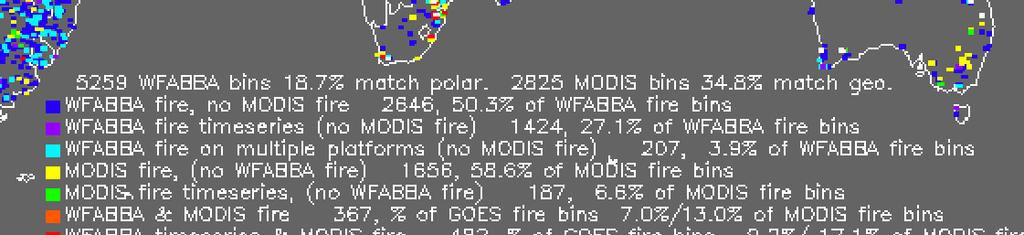
5 RAPv3/HRRRv2 Observation Data Assimilation Changes New in RAPv3/HRRRv2 Radial Velocity (RAPv3) Lightning (RAPv3) Mesonet (RAPv3/HRRRv2) RARS Radiances (RAPv3) 2016 Hourly Observation Type Variables Observed Observation Count Rawinsonde Temperature, humidity, wind, pressure 125 Profiler NOAA/ 915 MHz Wind, virtual temperature 2 / Radar VAD Wind 125 Radar Radial velocity 125 radars Radar reflectivity CONUS 3-d refl Latent htg, rain,snow,graupel ~1,500,000 Lightning NLDN / GOES-R Flash density Proxy reflectivity 10K Aircraft Wind, temperature 3,000-25,000 Aircraft - WVSS Humidity Surface/METAR Temperature, moisture, wind, press, clouds/ceiling, visibility, current weather Surface/Mesonet Temperature, moisture, wind ~5K-12K Buoys/ships Wind, pressure GOES AMVs Wind 10K AMSU/HIRS/MHS (RARS) Radiances (direct readout) 250K/200K/200KK GOES Radiances (fire location/intensity-smoke) ~3,000K GOES-R Lightning, cloud-top cooling >3,000K GOES cloud-top press/temp Brightness temp ~380K GPS Precipitable water Humidity 300 METOP-B AScat Winds ~30,000 4
6 RUC/RAP/HRRR: Improving Forecast Skill Crossover in forecast skill between Nowcasting/Extrapolation vs Numerical Weather Prediction Forecast Skill Less Skill More Skill -- Extrapolation -- Persistence HRRR 3-km Radar Data Assimilation RUC 13-km Radar Data Assimilation Pre-Radar Data Assimilation Improving forecast skill and halving crossover period every ~3-4 years Forecast Length (Hours) 5
 reflectivity")

7 RAP/HRRR: Improving Forecast Skill Critical Success Index X 100 Less Skill More Skill HRRR Forecast Skill for Reflectivity (30 dbz) reflectivity heating rate: low-cost assimilation, significant forecast improvement radar data assimilation in RAP and HRRR no radar data assimilation Forecast Length (Hours) 6
8 RAP/HRRR Development History Less Skill More Skill HRRR precipitation location skill improves by 50% over past 5 years Underforecast Overforecast HRRR precipitation bias reduced by 60% over past 5 years 7


9 RUC/RAP: Diabatic Digital Filter Assimilation Digital filter-based assimilation initializes ongoing / developing convection / precipitation regions Use for following obs types: Radar reflectivity Lightning Satellite cloud-top cooling rate -20 min -10 min Initial +10 min + 20 min Backwards integration, no physics Forward integration,full physics with obs-based latent heating Initial fields with improved balance, storm-scale circulation RUC / RAP model forecast 8


10 RUC/RAP: Diabatic Digital Filter Assimilation Latent Heating Promotes Mesoscale Circulations in Regions of Precipitation Observed Reflectivity U wind component difference (radar no radar) Low-Level Upper-Level Quick. Baseline for ens DA including HRRRE 1400 UTC 22 Oct 2008 Z = 3 km Enhanced Convergence Enhanced Divergence 9


11 RAP/HRRR Cloud and Precip Hydrometeor Analysis Observations Map to cloud field Merge cloud field Quick. Baseline for ens DA including HRRRE No cloud Cloud Unknown Update hydrometeors based on the cloud field 10
12 Rapid Refresh GSI Options Surface Obs Special treatments for surface observations Quick. Baseline for ens DA including HRRRE
13 GSI namelists from GSD Namelist explanation Default value RAP value dfi_radar_latent_heat_time_period DFI forward integration window in minutes metar_impact_radius METAR cloud obs impact radius in grid number metar_impact_radius_lowcloud l_gsd_terrain_match_surftobs l_sfcobserror_ramp_t l_sfcobserror_ramp_q l_pbl_pseudo_surfobst l_pbl_pseudo_surfobsq l_pbl_pseudo_surfobsuv pblh_ration METAR low cloud observation impact radius in grid number if.true., GSD terrain match for surface temperature observation namelist logical for adjusting surface temperature observation error namelist logical for adjusting surface moisture observation error if.true. produce pseudo-obs in PBL layer based on surface obs T if.true. produce pseudo-obs in PBL layer based on surface obs Q if.true. produce pseudo-obs in PBL layer based on surface obs UV percent of the PBL height within which to add pseudo-obs 4 4.true..true..true..true..false
14 GSI namelists from GSD Namelist explanation Default value RAP value dfi_radar_latent_heat_time_period DFI forward integration window in minutes metar_impact_radius METAR cloud obs impact radius in grid number metar_impact_radius_lowcloud l_gsd_terrain_match_surftobs l_sfcobserror_ramp_t l_sfcobserror_ramp_q l_pbl_pseudo_surfobst l_pbl_pseudo_surfobsq l_pbl_pseudo_surfobsuv pblh_ration METAR low cloud observation impact radius in grid number if.true., GSD terrain match for surface temperature observation namelist logical for adjusting surface temperature observation error namelist logical for adjusting surface moisture observation error if.true. produce pseudo-obs in PBL layer based on surface obs T if.true. produce pseudo-obs in PBL layer based on surface obs Q if.true. produce pseudo-obs in PBL layer based on surface obs UV percent of the PBL height within which to add pseudo-obs 4 4.true..true..true..true..false
15 Improved forward model for 2m surface obs when available, improved information matching l_use_2mq4b if.true. use 2m Q/T as part of background to calculate surface Q observation innovation.true. Z >>8m, k=1 level for NAM, GFS Z=8m, k=1 level for RAP (σ=0.998) Z=2m, shelter height for temp/dewpoint obs Z=0m, atmos/sfc interface
16 Purposes for RUA Rapidly Updated Analysis high-frequency environmental nowcasts 1. Pure situational awareness use all observations as precisely as possible. (Use high-res fcst as background, e.g., HRRR ) 2. Initial conditions for extrapolation model (e.g., AutoNowcaster, CIWS) 3. Initial conditions for hydrodynamic model (may require multivariate equilibrium not needed for #1 or #2). Note: #3 is approaching #1 and #2 but not there yet.
17 Vision: Unification for 3-d nowcasting under RUA Diagnose all other fields from 3-d best estimate of atmosphere/earth-system Cloud cover PBL height 80m winds RUA should include Water in all forms Atmosphere: water vapor, hydrometeor types (mixing ratio, number concentration, bins, etc.) Land-surface field soil, vegetation, snow cover Contribution to QPE 3-d aerosol/smoke/chemistry
18 Current nowcast components Observations Remotely sensed Radar MRMS national/international composite Ancillary radar CASA, etc. PBL profiler Satellite GOES, polar-orbiter radiance, cloud, scat Camera road cams, all-sky Ceilometer, visibility - cloud In situ surface, aircraft, raob, tower) Modern data assimilation merger GSI initializing 3km HRRR one start

19 RAP/HRRR variables updated in data assimilation


20 DA for Land Surface Model (LSM) for HRRR/RAP 9 soil layers, 2 snow layers Surface observations are used to update the LSM through the data assimilation step. For example, the soil temperature is decreased and soil moisture is increased where the model is too warm and too dry compared to the surface observations. Soil Temperature Example Soil Adjustments 20 UTC 03 June 2013 Soil Moisture Cooling Warming Moistening Drying


21 Snow-cover updating HRRRv2 full land-sfc/snow cycling Wyoming Nebraska Denver Colorado HRRRv2-exp ESRL HRRRv1-oper NCEP NOHRSC Snow water equivalent 06z 20 May 2015 inches
22 HRRRv2 Real-Time Evaluation: Precipitation 2013 Warm Season (June-August) HRRR 0-6 hr precipitation forecast Difference against Stage IV Dry Moist 21

23 HRRRv2 Real-Time Evaluation: Precipitation 2015 Warm Season (June-August) HRRR 0-6 hr precipitation forecast Difference against Stage IV Reduction in high precipitation bias Dry Moist 22


24 HRRR-chem assimilation of WFABBA HRRR-chem-3km PM25- sfc 11h fcst valid 17z 24 Feb
 WRF-Chem coupled")

25 RAP-chem assimilation of PM2.5 data Rapid Refresh with Chemistry Real time forecasts predicting weather and air quality based on WRF-Chem, GSI (Mariusz Pagowski) WRF-Chem coupled with chemistry via RACM chemical mechanism including MOSAIC/VBS for prediction of secondary organic aerosols (SOA). MEGAN biogenic emissions, NEI and RETRO/EDGAR anthropogenic emissions, Chemical deposition, Convective and turbulent chemical transport, Photolysis, Advective chemical transport performed simultaneously with meteorology ("online"), Lateral chemical boundary conditions obtained from RAQMS model real time forecasts. 24


26 HRRRE (HREF) Prototype 3- km stormscale HRRR ensemble domain 2016 Single core (ARW) Ensemble DA Stochastic physics Assimilation Forecast members 9 members 1 hr forecast hr forecast 21 cycles / day 4+ fcsts / day 21z Prev Day Start 00z, 12z, 15z, 18z Beginning development of formal 3-km data assimilation and forecast ensemble More accurate storm-details from ensemble data assimilation 25

27 Observations HRRRE (HREF) 12 hr Forecasts Valid 00 UTC 8 Mar 2016 Six Member Ensemble 26
28 Challenges of storm-scale DA number of radar and cloud observations highly variable in space/time: fair weather only a few observations, convective storms many observations methods needed to deal with non-gaussian ensemble distributions and nonlinear observation operators: variable transformations and/or advanced DA methods examples of non-gaussian distributions: (1) bimodal distributions (some ens members have conv storm, some don t), (2) raindrop number concentration example of nonlinear observation operator: reflectivity (proportional to log q if assimilated observation is in dbz) 27
29 Future for situational awareness DA Requirement - 5-min DA w/ radar and satellite data while maintaining quick speed keeping all data (grids esp.) in memory all the time is essential. Design toward an 80-mem 1km ensemble updating every 5 min, even global [Note: some evidence that if we do a good job computing the obs operators (ensemble priors) at the exact observation time, 10-min assimilation windows will be good enough for storm-scale DA] Coupled land-surface/chem/atmos DA - incl. sub-grid repr (e.g., clouds) on-demand capability for very high resolution applications: DA and NWP grids generated where there are risks of severe weather, heavy rain / snow, fire, etc.; grid discarded when risk is gone, perhaps after only a few hours Use of JEDI-like, community next-gen DA 28
Aircraft-based Observations: Impact on weather forecast model performance
 Aircraft-based Observations: Impact on weather forecast model performance Stephen S. Weygandt Eric James, Stan Benjamin, Bill Moninger, Brian Jamison, Geoff Manikin* NOAA Earth System Research Laboratory
2012 and changes to the Rapid Refresh and HRRR weather forecast models
 2012 and 2013-15 changes to the Rapid Refresh and HRRR weather forecast models 31 October 2012 Stan Benjamin Steve Weygandt Curtis Alexander NOAA Earth System Research Laboratory Boulder, CO FPAW - 2012
Canadian Meteorological and Oceanographic Society and American Meteorological Society 21 st Conference on Numerical Weather Prediction 31 May 2012
 Canadian Meteorological and Oceanographic Society and American Meteorological Society 21 st Conference on Numerical Weather Prediction 31 May 2012 The High Resolution Rapid Refresh (): An hourly updating
Plans for NOAA s regional ensemble systems: NARRE, HRRRE, and a regional hybrid assimilation
 NOAA Earth System Research Laboratory Plans for NOAA s regional ensemble systems: NARRE, HRRRE, and a regional hybrid assimilation Tom Hamill (substituting for Stan Benjamin and team) NOAA Earth System
NOAA s Severe Weather Forecasting System: HRRR to WoF to FACETS
 NOAA s Severe Weather Forecasting System: HRRR to WoF to FACETS David D NOAA / Earth System Research Laboratory / Global Systems Division Nowcasting and Mesoscale Research Working Group Meeting World Meteorological
Development of High-Resolution Rapid Refresh (HRRR) Ensemble Data Assimilation, Forecasts and Post Processing
 Ensemble Data Assimilation, Forecasts and Post Processing") 7 th Ensemble Users Workshop Ensemble Development I Development of High-Resolution Rapid Refresh (HRRR) Ensemble Data Assimilation, Forecasts and Post Processing 14 June 2016 Curtis Alexander, David Dowell,
7 th Ensemble Users Workshop Ensemble Development I Development of High-Resolution Rapid Refresh (HRRR) Ensemble Data Assimilation, Forecasts and Post Processing 14 June 2016 Curtis Alexander, David Dowell,
Development of High-Resolution Rapid Refresh (HRRR) Ensemble Data Assimilation, Forecast and Post-Processing
 Ensemble Data Assimilation, Forecast and Post-Processing") CORP Science Symposium, July 18-19, 2016, Fort Collins Development of High-Resolution Rapid Refresh (HRRR) Ensemble Data Assimilation, Forecast and Post-Processing Isidora Jankov, Curtis Alexander, David
CORP Science Symposium, July 18-19, 2016, Fort Collins Development of High-Resolution Rapid Refresh (HRRR) Ensemble Data Assimilation, Forecast and Post-Processing Isidora Jankov, Curtis Alexander, David
HRRR-AK: Status and Future of a High- Resolu8on Forecast Model for Alaska
 HRRR-AK: Status and Future of a High- Resolu8on Forecast Model for Alaska Trevor Alco* 1, Jiang Zhu 2, Don Morton 3, Ming Hu 4, Cur8s Alexander 1 1 ESRL Global Systems Division, Boulder, CO 2 GINA/UAF,
weather forecast Improving NOAA models for energy Stan Benjamin, Boulder, CO USA Joseph Olson, Curtis Alexander, Eric James,
 Lamont, OK X Obs radar 5h HRRR Forecast Improving NOAA weather forecast models for energy Stan Benjamin, Joseph Olson, Curtis Alexander, Eric James, Dave Turner, Melinda Marquis NOAA Earth System Research
Weather Hazard Modeling Research and development: Recent Advances and Plans
 Weather Hazard Modeling Research and development: Recent Advances and Plans Stephen S. Weygandt Curtis Alexander, Stan Benjamin, Geoff Manikin*, Tanya Smirnova, Ming Hu NOAA Earth System Research Laboratory
Enhancing short term wind energy forecasting for improved utility operations: The Wind Forecast Improvement Project (WFIP)
") Enhancing short term wind energy forecasting for improved utility operations: The Wind Forecast Improvement Project (WFIP) Jim Wilczak NOAA S. Benjamin, I. Djalalova, L. Bianco, S. Calvert, J. Freedman,
Enhancing short term wind energy forecasting for improved utility operations: The Wind Forecast Improvement Project (WFIP) Jim Wilczak NOAA S. Benjamin, I. Djalalova, L. Bianco, S. Calvert, J. Freedman,
Introduction to NCEP's time lagged North American Rapid Refresh Ensemble Forecast System (NARRE-TL)
") Introduction to NCEP's time lagged North American Rapid Refresh Ensemble Forecast System (NARRE-TL) Binbin Zhou 1,2, Jun Du 2, Geoff Manikin 2 & Geoff DiMego 2 1. I.M. System Group 2. EMC/NCEP/NWS/NOAA
Introduction to NCEP's time lagged North American Rapid Refresh Ensemble Forecast System (NARRE-TL) Binbin Zhou 1,2, Jun Du 2, Geoff Manikin 2 & Geoff DiMego 2 1. I.M. System Group 2. EMC/NCEP/NWS/NOAA
The Nowcasting Demonstration Project for London 2012
 The Nowcasting Demonstration Project for London 2012 Susan Ballard, Zhihong Li, David Simonin, Jean-Francois Caron, Brian Golding, Met Office, UK Introduction The success of convective-scale NWP is largely
A 21st century HRRR-based approach to estimating probable maximum precipitation to enhance dam safety and community resilience
 30 May 2017 FIRO Science Task Group Workshop A 21st century HRRR-based approach to estimating probable maximum precipitation to enhance dam safety and community resilience Courtesy Bill McCormick, Chief,
Development of an Hourly- Updated NAM Forecast System
 Development of an Hourly- Updated NAM Forecast System Jacob Carley ab, Eric Rogers b, Shun Liu ab, Brad Ferrier ab, Eric Aligo ab, Matthew Pyle b, and Geoff DiMego b a IMSG, b NOAA/NWS/NCEP/EMC jacob.carley@noaa.gov
The WMO Observation Impact Workshop. lessons for SRNWP. Roger Randriamampianina
 The WMO Observation Impact Workshop - developments outside Europe and lessons for SRNWP Roger Randriamampianina Hungarian Meteorological Service (OMSZ) Outline Short introduction of the workshop Developments
Some Applications of WRF/DART
 Some Applications of WRF/DART Chris Snyder, National Center for Atmospheric Research Mesoscale and Microscale Meteorology Division (MMM), and Institue for Mathematics Applied to Geoscience (IMAGe) WRF/DART
J3.4 FROM THE RADAR-ENHANCED RUC TO THE WRF-BASED RAPID REFRESH. NOAA Earth System Research Laboratory, Boulder, CO
 22 nd Conf. Wea. Analysis Forecasting / 18 th Conf. Num Wea. Pred., June 2007, Park City, UT, Amer. Meteor. Soc. J3.4 FROM THE RADAR-ENHANCED RUC TO THE WRF-BASED RAPID REFRESH Stan Benjamin, Stephen S.
Figure 1. Observations assimilated into RUC as of 2008 after upgrade, new observations in bold and with leading arrows.
 6.2 IMPLEMENTATION OF THE RADAR-ENHANCED RUC Stan Benjamin, Stephen S. Weygandt, John M. Brown, Tanya Smirnova 2, Dezso Devenyi 2, Kevin Brundage 3, Georg Grell 2, Steven Peckham 2, William R. Moninger,
Convection-Resolving NWP with WRF. Section coordinator Ming Xue University of Oklahoma
 Convection-Resolving NWP with WRF Section coordinator Ming Xue University of Oklahoma Convection-resolving NWP Is NWP that explicitly treats moist convective systems ranging from organized MCSs to individual
Toward improved initial conditions for NCAR s real-time convection-allowing ensemble. Ryan Sobash, Glen Romine, Craig Schwartz, and Kate Fossell
 Toward improved initial conditions for NCAR s real-time convection-allowing ensemble Ryan Sobash, Glen Romine, Craig Schwartz, and Kate Fossell Storm-scale ensemble design Can an EnKF be used to initialize
A Cycled GSI+EnKF and Storm-Scale Ensemble Forecasting (SSEF) Experiment
 Experiment") A Cycled GSI+EnKF and Storm-Scale Ensemble Forecasting (SSEF) Experiment Fanyou Kong, Ming Xue, Youngsun Jung, Keith A. Brewster, Gang Zhao Center for Analysis and Prediction of Storms University of Oklahoma
A Cycled GSI+EnKF and Storm-Scale Ensemble Forecasting (SSEF) Experiment Fanyou Kong, Ming Xue, Youngsun Jung, Keith A. Brewster, Gang Zhao Center for Analysis and Prediction of Storms University of Oklahoma
Recent Performance of the NOAA Air Quality Forecasting Capability and the Impact of Driving Meteorology
 Recent Performance of the NOAA Air Quality Forecasting Capability and the Impact of Driving Meteorology http://www.emc.ncep.noaa.gov/mmb/aq Jeff McQueen, Jianping Huang, Ho-Chun Huang, Perry Shafran NCEP/EMC
1. Current atmospheric DA systems 2. Coupling surface/atmospheric DA 3. Trends & ideas
 1 Current issues in atmospheric data assimilation and its relationship with surfaces François Bouttier GAME/CNRM Météo-France 2nd workshop on remote sensing and modeling of surface properties, Toulouse,
FAA Weather Research Plans
 FAA Weather Research Plans Presented to: Friends /Partners in Aviation Weather Vision Forum By: Ray Moy FAA Aviation Weather Office Date: Aviation Weather Research Program (AWRP) Purpose: Applied Research
Project Summary 2015 DTC Task MM5: Test of an Expanded WRF-ARW Domain
 1. Introduction Project Summary 2015 DTC Task MM5: Test of an Expanded WRF-ARW Domain Trevor Alcott Ligia Bernardet Isidora Jankov The High-Resolution Rapid Refresh (HRRR) model represents a major step
Assimilation of Mesoscale Observations for use in Numerical Weather Prediction
 Assimilation of Mesoscale Observations for use in Numerical Weather Prediction Steve Koch Thermodynamic Profiling Technologies Workshop Boulder 12 14 April 2011 Important Questions (from 2003 USWRP Mesoscale
Weather Forecasting: Lecture 2
 Weather Forecasting: Lecture 2 Dr. Jeremy A. Gibbs Department of Atmospheric Sciences University of Utah Spring 2017 1 / 40 Overview 1 Forecasting Techniques 2 Forecast Tools 2 / 40 Forecasting Techniques
Update on CoSPA Storm Forecasts
 Update on CoSPA Storm Forecasts Haig August 2, 2011 This work was sponsored by the Federal Aviation Administration under Air Force Contract No. FA8721-05-C-0002. Opinions, interpretations, conclusions,
Convective-scale NWP for Singapore
 Convective-scale NWP for Singapore Hans Huang and the weather modelling and prediction section MSS, Singapore Dale Barker and the SINGV team Met Office, Exeter, UK ECMWF Symposium on Dynamical Meteorology
11.1 CONVECTION FORECASTS FROM THE HOURLY UPDATED, 3-KM HIGH RESOLUTION RAPID REFRESH (HRRR) MODEL
 MODEL") Preprints, 24 th Conference on Severe Local Storms, October 2008, Savannah, GA, Amer. Meteor. Soc. 11.1 CONVECTION FORECASTS FROM THE HOURLY UPDATED, 3-KM HIGH RESOLUTION RAPID REFRESH (HRRR) MODEL Tracy
Preprints, 24 th Conference on Severe Local Storms, October 2008, Savannah, GA, Amer. Meteor. Soc. 11.1 CONVECTION FORECASTS FROM THE HOURLY UPDATED, 3-KM HIGH RESOLUTION RAPID REFRESH (HRRR) MODEL Tracy
Hyperlocal Marine Weather: What s Happening?
 Hyperlocal Marine Weather: What s Happening? André van der Westhuysen 1,2 and Jeff McQueen 1 1 NOAA / National Weather Service National Centers for Environmental Prediction 2 I.M Systems Group, Rockville
The EMC Mission.. In response to operational requirements:
 The EMC Mission.. In response to operational requirements: Maintain operational model suite The scientific correctness and integrity of operational forecast modeling systems Modify current operational
Convective-scale Warn-on-Forecast The Future of Severe Weather Warnings in the USA?
 Convective-scale Warn-on-Forecast The Future of Severe Weather Warnings in the USA? David J. Stensrud Department of Meteorology The Pennsylvania State University Present Warning System: 2 March 2012 Warning
Masahiro Kazumori, Takashi Kadowaki Numerical Prediction Division Japan Meteorological Agency
 Development of an all-sky assimilation of microwave imager and sounder radiances for the Japan Meteorological Agency global numerical weather prediction system Masahiro Kazumori, Takashi Kadowaki Numerical
Impact of assimilating the VIIRS-based CrIS cloudcleared radiances on hurricane forecasts
 Impact of assimilating the VIIRS-based CrIS cloudcleared radiances on hurricane forecasts Jun Li @, Pei Wang @, Jinlong Li @, Zhenglong Li @, Jung-Rim Lee &, Agnes Lim @, Timothy J. Schmit #, and Mitch
Utilising Radar and Satellite Based Nowcasting Tools for Aviation Purposes in South Africa. Erik Becker
 Utilising Radar and Satellite Based Nowcasting Tools for Aviation Purposes in South Africa Erik Becker Morné Gijben, Mary-Jane Bopape, Stephanie Landman South African Weather Service: Nowcasting and Very
Denver International Airport MDSS Demonstration Verification Report for the Season
 Denver International Airport MDSS Demonstration Verification Report for the 2015-2016 Season Prepared by the University Corporation for Atmospheric Research Research Applications Division (RAL) Seth Linden
0-6 hour Weather Forecast Guidance at The Weather Company. Steven Honey, Joseph Koval, Cathryn Meyer, Peter Neilley The Weather Company
 1 0-6 hour Weather Forecast Guidance at The Weather Company Steven Honey, Joseph Koval, Cathryn Meyer, Peter Neilley The Weather Company TWC Forecasts: Widespread Adoption 2 0-6 Hour Forecast Details 3
Recent Data Assimilation Activities at Environment Canada
 Recent Data Assimilation Activities at Environment Canada Major upgrade to global and regional deterministic prediction systems (now in parallel run) Sea ice data assimilation Mark Buehner Data Assimilation
ASSIMILATION OF METAR CLOUD AND VISIBILITY OBSERVATIONS IN THE RUC
 9.13 ASSIMILATION OF METAR CLOUD AND VISIBILITY OBSERVATIONS IN THE RUC Stanley G. Benjamin, Stephen S. Weygandt, John M. Brown, Tracy Lorraine Smith 1, Tanya Smirnova 2, William R. Moninger, Barry Schwartz,
Real-time PBL analysis system using profilers observations from The New York State Mesonet
 Real-time PBL analysis system using profilers observations from The New York State Mesonet Sarah Lu University at Albany State University of New York Outline Background System description and progress
Scatterometer Wind Assimilation at the Met Office
 Scatterometer Wind Assimilation at the Met Office James Cotton International Ocean Vector Winds Science Team (IOVWST) meeting, Brest, June 2014 Outline Assimilation status Global updates: Metop-B and spatial
RTMA Flowchart (CONUS)
") 22 nd Conf. Wea. Analysis Forecasting / 18 th Conf. Num Wea. Pred., June 2007, Park City, UT, Amer. Meteor. Soc. 4A.6 THE RTMA BACKGROUND HOURLY DOWNSCALING OF RUC DATA TO 5-KM DETAIL Stan Benjamin, John
22 nd Conf. Wea. Analysis Forecasting / 18 th Conf. Num Wea. Pred., June 2007, Park City, UT, Amer. Meteor. Soc. 4A.6 THE RTMA BACKGROUND HOURLY DOWNSCALING OF RUC DATA TO 5-KM DETAIL Stan Benjamin, John
Variational data assimilation of lightning with WRFDA system using nonlinear observation operators
 Variational data assimilation of lightning with WRFDA system using nonlinear observation operators Virginia Tech, Blacksburg, Virginia Florida State University, Tallahassee, Florida rstefane@vt.edu, inavon@fsu.edu
Jordan G. Powers Kevin W. Manning. Mesoscale and Microscale Meteorology Laboratory National Center for Atmospheric Research Boulder, Colorado, USA
 Jordan G. Powers Kevin W. Manning Mesoscale and Microscale Meteorology Laboratory National Center for Atmospheric Research Boulder, Colorado, USA Background : Model for Prediction Across Scales = Global
Unidata Policy Meeting Key Program Status
 Unidata Policy Meeting Key Program Status May 14, 2013 Where America s Climate, Weather, Ocean and Space Weather Services Begin Agenda Sandy Supplemental Integrated Dissemination Program AWIPS2 May, 2013
RUC development on ceiling/visibility forecasts
 RUC development on ceiling/visibility forecasts Stan Benjamin John M. Brown NOAA / FSL Stan.Benjamin@noaa.gov john.m.brown@noaa.gov 303-497-6387 303-497-6867 http://ruc.fsl.noaa.gov Bill Moninger Ed Szoke
Thunderstorm-Scale EnKF Analyses Verified with Dual-Polarization, Dual-Doppler Radar Data
 Thunderstorm-Scale EnKF Analyses Verified with Dual-Polarization, Dual-Doppler Radar Data David Dowell and Wiebke Deierling National Center for Atmospheric Research, Boulder, CO Ensemble Data Assimilation
Chengsi Liu 1, Ming Xue 1, 2, Youngsun Jung 1, Lianglv Chen 3, Rong Kong 1 and Jingyao Luo 3 ISDA 2019
 Development of Optimized Radar Data Assimilation Capability within the Fully Coupled EnKF EnVar Hybrid System for Convective Permitting Ensemble Forecasting and Testing via NOAA Hazardous Weather Testbed
Report on EN2 DTC Ensemble Task 2015: Testing of Stochastic Physics for use in NARRE
 Report on EN2 DTC Ensemble Task 2015: Testing of Stochastic Physics for use in NARRE Motivation: With growing evidence that initial- condition uncertainties are not sufficient to entirely explain forecast
Convection-Allowing Models (CAMs) A discussion on Creating a Roadmap to a Unified CAM-based Data-Assimilation and Forecast Ensemble
 A discussion on Creating a Roadmap to a Unified CAM-based Data-Assimilation and Forecast Ensemble") Convection-Allowing Models (CAMs) A discussion on Creating a Roadmap to a Unified CAM-based Data-Assimilation and Forecast Ensemble Panel Members Curtis Alexander (ESRL/GSD) Adam Clark (NSSL) Lucas Harris
Convection-Allowing Models (CAMs) A discussion on Creating a Roadmap to a Unified CAM-based Data-Assimilation and Forecast Ensemble Panel Members Curtis Alexander (ESRL/GSD) Adam Clark (NSSL) Lucas Harris
HIGH RESOLUTION RAPID REFRESH COUPLED WITH SMOKE (HRRR- SMOKE): REAL-TIME AIR QUALITY MODELING SYSTEM AND ITS APPLICATION TO CASE STUDIES
: REAL-TIME AIR QUALITY MODELING SYSTEM AND ITS APPLICATION TO CASE STUDIES") HIGH RESOLUTION RAPID REFRESH COUPLED WITH SMOKE (HRRR- SMOKE): REAL-TIME AIR QUALITY MODELING SYSTEM AND ITS APPLICATION TO CASE STUDIES Ravan Ahmadov 1,2 (ravan.ahmadov@noaa.gov) Acknowledgement: G.
HIGH RESOLUTION RAPID REFRESH COUPLED WITH SMOKE (HRRR- SMOKE): REAL-TIME AIR QUALITY MODELING SYSTEM AND ITS APPLICATION TO CASE STUDIES Ravan Ahmadov 1,2 (ravan.ahmadov@noaa.gov) Acknowledgement: G.
Assimilation of Satellite Infrared Brightness Temperatures and Doppler Radar Observations in a High-Resolution OSSE
 Assimilation of Satellite Infrared Brightness Temperatures and Doppler Radar Observations in a High-Resolution OSSE Jason Otkin and Becky Cintineo University of Wisconsin-Madison, Cooperative Institute
4.5 A WRF-DART study of the nontornadic and tornadic supercells intercepted by VORTEX2 on 10 June 2010
 4.5 A WRF-DART study of the nontornadic and tornadic supercells intercepted by VORTEX2 on 10 June 2010 ALICIA M. KLEES AND YVETTE P. RICHARDSON The Pennsylvania State University, University Park, Pennsylvania.
Michael F. Stringfellow
 Michael F. Stringfellow Thermals Columns or bubbles of warm air that rise from the ground when it is heated by the sun Soaring Sustained engineless flight using natural sources of lift Boundary or mixing
Implementation and Evaluation of WSR-88D Reflectivity Data Assimilation for WRF-ARW via GSI and Cloud Analysis. Ming Hu University of Oklahoma
 Implementation and Evaluation of WSR-88D Reflectivity Data Assimilation for WRF-ARW via GSI and Cloud Analysis Ming Hu University of Oklahoma 1. Previous work and Goal of visiting Previous work: Radar
NCEP s "NAM" (North American Mesoscale) model WRF-NMM. NCEP =National Centers for Environmental Prediction
 model WRF-NMM. NCEP =National Centers for Environmental Prediction") NCEP s "NAM" (North American Mesoscale) model WRF-NMM NCEP =National Centers for Environmental Prediction Weather Research and Forecasting Non-hydrostatic Mesoscale Model (WRF-NMM)** model is run as the
NCEP s "NAM" (North American Mesoscale) model WRF-NMM NCEP =National Centers for Environmental Prediction Weather Research and Forecasting Non-hydrostatic Mesoscale Model (WRF-NMM)** model is run as the
CAPS Storm-Scale Ensemble Forecasting (SSEF) System
 System") CAPS Storm-Scale Ensemble Forecasting (SSEF) System Fanyou Kong, Ming Xue, Xuguang Wang, Keith Brewster Center for Analysis and Prediction of Storms University of Oklahoma (collaborated with NSSL, SPC,
CAPS Storm-Scale Ensemble Forecasting (SSEF) System Fanyou Kong, Ming Xue, Xuguang Wang, Keith Brewster Center for Analysis and Prediction of Storms University of Oklahoma (collaborated with NSSL, SPC,
The NOAA Operational Numerical Guidance System: Recent Changes and Moving Forward. William. M. Lapenta Acting Director Environmental Modeling Center
 AMS Future of the Weather Enterprise 11/27/12 1 N C E P The NOAA Operational Numerical Guidance System: Recent Changes and Moving Forward William. M. Lapenta Acting Director Environmental Modeling Center
The Developmental Testbed Center: Update on Data Assimilation System Testing and Community Support
 93rd AMS Annual Meeting/17th IOAS-AOLS/3rd Conference on Transition of Research to Operations, Austin, TX, Jan 6-10, 2013 The Developmental Testbed Center: Update on Data Assimilation System Testing and
Current and future configurations of MOGREPS-UK. Susanna Hagelin EWGLAM/SRNWP, Rome, 4 Oct 2016
 Current and future configurations of MOGREPS-UK Susanna Hagelin EWGLAM/SRNWP, Rome, 4 Oct 2016 Contents Current configuration PS38 and package trial results Soil moisture perturbations case study Future
ENSEMBLE FORECASTS AND VERIFICATION OF THE MAY 2015 MULTI-HAZARD SEVERE WEATHER EVENT IN OKLAHOMA. Austin Coleman 1, Nusrat Yussouf 2
 ENSEMBLE FORECASTS AND VERIFICATION OF THE MAY 2015 MULTI-HAZARD SEVERE WEATHER EVENT IN OKLAHOMA Austin Coleman 1, Nusrat Yussouf 2 1 National Weather Center Research Experience for Undergraduates Program,
DATA FUSION NOWCASTING AND NWP
 DATA FUSION NOWCASTING AND NWP Brovelli Pascal 1, Ludovic Auger 2, Olivier Dupont 1, Jean-Marc Moisselin 1, Isabelle Bernard-Bouissières 1, Philippe Cau 1, Adrien Anquez 1 1 Météo-France Forecasting Department
The role of testbeds in NOAA for transitioning NWP research to operations
 ECMWF Workshop on Operational Systems November 18, 2013 The role of testbeds in NOAA for transitioning NWP research to operations Ligia Bernardet 1* and Zoltan Toth 1 1 NOAA ESRL Global Systems Division,
Assimilation of cloud/precipitation data at regional scales
 Assimilation of cloud/precipitation data at regional scales Thomas Auligné National Center for Atmospheric Research auligne@ucar.edu Acknowledgments to: Steven Cavallo, David Dowell, Aimé Fournier, Hans
Real-Time Meteorological Gridded Data: What s New With HEC-RAS
 Real-Time Meteorological Gridded Data: What s New With HEC-RAS Acquisition and Application of Gridded Meteorological Data in Support of the USACE s Real-Time Water Management Mission Fauwaz Hanbali, Tom
Utilization of Forecast Models in High Temporal GOES Sounding Retrievals
 Utilization of Forecast Models in High Temporal GOES Sounding Retrievals Zhenglong Li, Jun Li, W. Paul Menzel, Steve Ackerman CIMSS/UW The CoRP Symposium Aug 12-13, 2008 Corvallis, OR Introduction: GOES
Operational Use of Scatterometer Winds in the JMA Data Assimilation System
 Operational Use of Scatterometer Winds in the Data Assimilation System Masaya Takahashi Numerical Prediction Division, Japan Meteorological Agency () International Ocean Vector Winds Science Team Meeting,
Deterministic and Ensemble Storm scale Lightning Data Assimilation
 LI Mission Advisory Group & GOES-R Science Team Workshop 27-29 May 2015 Deterministic and Ensemble Storm scale Lightning Data Assimilation Don MacGorman, Ted Mansell (NOAA/National Severe Storms Lab) Alex
The Planetary Boundary Layer and Uncertainty in Lower Boundary Conditions
 The Planetary Boundary Layer and Uncertainty in Lower Boundary Conditions Joshua Hacker National Center for Atmospheric Research hacker@ucar.edu Topics The closure problem and physical parameterizations
Consolidated Storm Prediction for Aviation (CoSPA) Overview
 Overview") Consolidated Storm Prediction for Aviation (CoSPA) Overview Ray Moy (FAA), Bill Dupree (MIT LL Lead), and Matthias Steiner (NCAR Lead) 27 September 2007 NBAA User Panel Review - 1 Consolidated Storm Prediction
Consolidated Storm Prediction for Aviation (CoSPA) Overview Ray Moy (FAA), Bill Dupree (MIT LL Lead), and Matthias Steiner (NCAR Lead) 27 September 2007 NBAA User Panel Review - 1 Consolidated Storm Prediction
Advances in weather modelling
 Advances in weather modelling www.cawcr.gov.au Robert Fawcett - speaking on behalf of CAWCR Earth-System Modelling and CAWCR Weather and Environmental Prediction May 2013 The Centre for Australian Weather
A new mesoscale NWP system for Australia
 A new mesoscale NWP system for Australia www.cawcr.gov.au Peter Steinle on behalf of : Earth System Modelling (ESM) and Weather&Environmental Prediction (WEP) Research Programs, CAWCR Data Assimilation
Emerging Aviation Weather Research at MIT Lincoln Laboratory*
 Emerging Aviation Weather Research at MIT Lincoln Laboratory* Haig 19 November 2015 *This work was sponsored by the Federal Aviation Administration under Air Force Contract No. FA8721-05-C-0002. Opinions,
GSI Data Assimilation System Support and Testing Activities: 2013 Annual Update
 14Th Annual WRF Users Workshop, Boulder, CO, June 24-28, 2013 GSI Data Assimilation System Support and Testing Activities: 2013 Annual Update Hui Shao1, Ming Hu2, Chunhua Zhou1, Kathryn Newman1, Mrinal
Air Force Weather Agency
 Air Force Weather Agency NWP & Implementation of the GSI at AFWA Jay Martinelli 8 August Precision Airdrop Systems Mission Military Operations, USDA, Intelligence Community Crop Production & Soil Conditions
Development of the Canadian Precipitation Analysis (CaPA) and the Canadian Land Data Assimilation System (CaLDAS)
 and the Canadian Land Data Assimilation System (CaLDAS)") Development of the Canadian Precipitation Analysis (CaPA) and the Canadian Land Data Assimilation System (CaLDAS) Marco L. Carrera, Vincent Fortin and Stéphane Bélair Meteorological Research Division Environment
Development of the Canadian Precipitation Analysis (CaPA) and the Canadian Land Data Assimilation System (CaLDAS) Marco L. Carrera, Vincent Fortin and Stéphane Bélair Meteorological Research Division Environment
Review of GFS Forecast Skills in 2012
 Review of GFS Forecast Skills in 2012 Fanglin Yang IMSG - Environmental Modeling Center National Centers for Environmental Prediction Acknowledgments: All NCEP EMC Global Climate and Weather Modeling Branch
CONDUIT Update Cooperative Opportunity for NCEP Data using IDD Technology Rebecca Cosgrove NCEP/NCO/Production Management Branch September 15, 2014
 CONDUIT Update Cooperative Opportunity for NCEP Data using IDD Technology Rebecca Cosgrove NCEP/NCO/Production Management Branch September 15, 2014 Agenda Technology Refresh Data available today NOAAPORT/SBN
Report on EN6 DTC Ensemble Task 2014: Preliminary Configuration of North American Rapid Refresh Ensemble (NARRE)
") Report on EN6 DTC Ensemble Task 2014: Preliminary Configuration of North American Rapid Refresh Ensemble (NARRE) Motivation As an expansion of computing resources for operations at EMC is becoming available
Report on EN6 DTC Ensemble Task 2014: Preliminary Configuration of North American Rapid Refresh Ensemble (NARRE) Motivation As an expansion of computing resources for operations at EMC is becoming available
Localized Aviation Model Output Statistics Program (LAMP): Improvements to convective forecasts in response to user feedback
: Improvements to convective forecasts in response to user feedback") Localized Aviation Model Output Statistics Program (LAMP): Improvements to convective forecasts in response to user feedback Judy E. Ghirardelli National Weather Service Meteorological Development Laboratory
Localized Aviation Model Output Statistics Program (LAMP): Improvements to convective forecasts in response to user feedback Judy E. Ghirardelli National Weather Service Meteorological Development Laboratory
Evaluation of Ensemble Icing Probability Forecasts in NCEP s SREF, VSREF and NARRE-TL Systems
 Evaluation of Ensemble Icing Probability Forecasts in NCEP s, V and Systems Binbin Zhou 1,2, Jun Du 2, Geoff DeMigo 2 and Robert Sallee 3 1. I.M. System Group 2. Environmental Modeling Center of NCEP 3.
Evaluating Parametrizations using CEOP
 Evaluating Parametrizations using CEOP Paul Earnshaw and Sean Milton Met Office, UK Crown copyright 2005 Page 1 Overview Production and use of CEOP data Results SGP Seasonal & Diurnal cycles Other extratopical
5. General Circulation Models
 5. General Circulation Models I. 3-D Climate Models (General Circulation Models) To include the full three-dimensional aspect of climate, including the calculation of the dynamical transports, requires
Northeastern United States Snowstorm of 9 February 2017
 Northeastern United States Snowstorm of 9 February 2017 By Richard H. Grumm and Charles Ross National Weather Service State College, PA 1. Overview A strong shortwave produced a stripe of precipitation
JOINT WMO TECHNICAL PROGRESS REPORT ON THE GLOBAL DATA PROCESSING AND FORECASTING SYSTEM AND NUMERICAL WEATHER PREDICTION RESEARCH ACTIVITIES FOR 2016
 JOINT WMO TECHNICAL PROGRESS REPORT ON THE GLOBAL DATA PROCESSING AND FORECASTING SYSTEM AND NUMERICAL WEATHER PREDICTION RESEARCH ACTIVITIES FOR 2016 New Zealand / Meteorological Service of New Zealand
Wind Assessment & Forecasting
 Wind Assessment & Forecasting GCEP Energy Workshop Stanford University April 26, 2004 Mark Ahlstrom CEO, WindLogics Inc. mark@windlogics.com WindLogics Background Founders from supercomputing industry
FPAW October Pat Murphy & David Bright NWS Aviation Weather Center
 FPAW October 2014 Pat Murphy & David Bright NWS Aviation Weather Center Overview Ensemble & Probabilistic Forecasts What AWC Is Doing Now Ensemble Processor What s In Development (NOAA Aviation Weather
Operational Uses of Bands on the GOES-R Advanced Baseline Imager (ABI) Presented by: Kaba Bah
 Presented by: Kaba Bah") Operational Uses of Bands on the GOES-R Advanced Baseline Imager (ABI) Presented by: Kaba Bah Topics: Introduction to GOES-R & ABI ABI individual bands Use of band differences ABI derived products Conclusions
Operational Uses of Bands on the GOES-R Advanced Baseline Imager (ABI) Presented by: Kaba Bah Topics: Introduction to GOES-R & ABI ABI individual bands Use of band differences ABI derived products Conclusions
Improvements to the NCEP Global and Regional Data Assimilation Systems
 Improvements to the NCEP Global and Regional Data Assimilation Systems Stephen J. Lord Director NCEP Environmental Modeling Center EMC Staff NCEP: where America s climate, weather, and ocean services begin
NOAA Research and Development Supporting NextGen. Darien Davis NOAA Office of Oceanic and Atmospheric Research June 22, 2009
 NOAA Research and Development Supporting NextGen Darien Davis Darien.l.davis@noaa.gov NOAA Office of Oceanic and Atmospheric Research June 22, 2009 FAA/NOAA Coordination Developing an integrated science
Assimilation of Doppler radar observations for high-resolution numerical weather prediction
 Assimilation of Doppler radar observations for high-resolution numerical weather prediction Susan Rennie, Peter Steinle, Mark Curtis, Yi Xiao, Alan Seed Introduction Numerical Weather Prediction (NWP)
1 hourly Rapid Update Cycle Detailed LACE DA action and challenges for 2015 and beyond written by Mate Mile
 1 hourly Rapid Update Cycle Detailed LACE DA action and challenges for 2015 and beyond written by Mate Mile 1. Introduction 2. Examples and existing systems 3. Challenges 4. Plans for actions 5. References
Convective-scale data assimilation at the UK Met Office
 Convective-scale data assimilation at the UK Met Office DAOS meeting, Exeter 25 April 2016 Rick Rawlins Hd(DAE) Acknowledgments: Bruce Macpherson and team Contents This presentation covers the following
Assimilation of radar reflectivity
 Assimilation of radar reflectivity Axel Seifert Deutscher Wetterdienst, Offenbach, Germany Convective-scale NWP at DWD: Plans for 2020 Storm-scale ICON-RUC-EPS: hourly 12h ensemble forecasts based on short
Enhancing Weather Forecasts via Assimilating SMAP Soil Moisture and NRT GVF
 CICS Science Meeting, ESSIC, UMD, 2016 Enhancing Weather Forecasts via Assimilating SMAP Soil Moisture and NRT GVF Li Fang 1,2, Christopher Hain 1,2, Xiwu Zhan 2, Min Huang 1,2 Jifu Yin 1,2, Weizhong Zheng
1. Introduction 8.4. * Corresponding author address: Steve Weygandt, NOAA/GSD, R/E/GSD, 325 Broadway, Boulder, CO
 Preprints, 12 th Conf. on IOAS-AOLS. January 2008, New Orleans, LA, Amer. Meteor. Soc. 8.4 Assimilation of radar reflectivity data using a diabatic digital filter within the Rapid Update Cycle Stephen
Land Data Assimilation at NCEP NLDAS Project Overview, ECMWF HEPEX 2004
 Dag.Lohmann@noaa.gov, Land Data Assimilation at NCEP NLDAS Project Overview, ECMWF HEPEX 2004 Land Data Assimilation at NCEP: Strategic Lessons Learned from the North American Land Data Assimilation System
Data Assimilation for Tropospheric CO. Avelino F. Arellano, Jr. Atmospheric Chemistry Division National Center for Atmospheric Research
 Data Assimilation for Tropospheric CO Avelino F. Arellano, Jr. Atmospheric Chemistry Division National Center for Atmospheric Research Caveat: Illustrative rather than quantitative, applied rather than