JPSS. Suomi NPP* satellite, JPSS-1 satellite, and JPSS-2 satellite Four primary instruments (ATMS, CrIS, VIIRS, OMPS)
|
|
|
- Junior Fleming
- 5 years ago
- Views:
Transcription


1 Operational and Research Applications from the Joint Polar Satellite System (JPSS) Nove be November AOMSUC-5 Mitch Goldberg, JPSS Program Scientist Presented by: Lihang Zhou, JPSS STAR (JSTAR) Program Manager National Environmental Satellite, Data, and Information Service National Oceanic and Atmospheric Administration 1
2 JPSS Overview: Suomi NPP* satellite, JPSS-1 satellite, and JPSS-2 satellite Four primary instruments (ATMS, CrIS, VIIRS, OMPS) Global Gl b l ground d system t (Alaska, (Al k Colorado, C l d Maryland, M l d West W t Virginia, Vi i i Svalbard, S lb d Antarctica) Implementation Partnerships with NASA, EUMETSAT, JAXA, NSF, DoD, NSC S-NPP is now NOAA s Primary Satellite *Suomi NPP is a joint NASA / NOAA mission *Launch Date based on FY 2014 President s Budget Request 2


3 JPSS-1 Instruments (same as S-NPP) JPSS Instrument ATMS - Advanced Technology Microwave Sounder CrIS C IS - Cross-track C t k Infrared I f d Sounder VIIRS Visible Infrared Imaging Radiometer Suite Measurement ATMS and CrIS together g p provide high g vertical resolution temperature and water vapor information needed to maintain and improve forecast skill out to 5 to 7 days y in advance for extreme weather events, including hurricanes and severe weather outbreaks VIIRS provides id many critical iti l imagery i products including snow/ice cover, clouds, fog, aerosols, fire, smoke plumes, vegetation health, h t l kt abundance/chlorophyll b d / hl h ll phytoplankton OMPS - Ozone Mapping and Profiler Suite Ozone spectrometers for monitoring ozone hole and recovery of stratospheric ozone and for UV index forecasts CERES - Clouds and the Earth s Radiant Energy System Scanning radiometer which supports studies of Earth Radiation Budget 3
4 S-NPP and JPSS Data Products From NOAA available in real-time VIIRS (24) ALBEDO (SURFACE) CLOUD BASE HEIGHT CLOUD COVER/LAYERS CLOUD EFFECTIVE PART SIZE CLOUD OPTICAL THICKNESS CLOUD TOP HEIGHT CLOUD TOP PRESSURE CLOUD TOP TEMPERATURE ICE SURFACE TEMPERATURE OCEAN COLOR/CHLOROPHYLL SUSPENDED MATTER VEGETATION INDEX, FRACTION, HEALTH AEROSOL OPTICAL THICKNESS AEROSOL PARTICLE SIZE ACTIVE FIRES POLAR WINDS IMAGERY SEA ICE CHARACTERIZATION SNOW COVER SEA SURFACE TEMPERATURE LAND SURFACE TEMP SURFACE TYPE CIS/ATMS(3) CrIS/ATMS ATM VERT MOIST PROFILE ATM VERT TEMP PROFILE CARBON (CO2, CH4, CO) ATMS (11) CLOUD LIQUID WATER PRECIPITATION RATE PRECIPITABLE WATER LAND SURFACE EMISSIVITY ICE WATER PATH LAND SURFACE TEMPERATURE SEA ICE CONCENTRATION SNOW COVER SNOW WATER EQUIVALENT ATM TEMPERATURE PROFILE ATM MOISTURE PROFILE OMPS (2) O 3 TOTAL COLUMN O 3 NADIR PROFILE SO2 and Aerosol Index GCOM AMSR 2 (11) CLOUD LIQUID WATER PRECIPITATION TYPE/RATE PRECIPITABLE WATER SEA SURFACE WINDS SPEED SOIL MOISTURE SNOW WATER EQUIVALENT IMAGERY SEA ICE CHARACTERIZATION SNOW COVER/DEPTH SEA SURFACE TEMPERATURE SURFACE TYPE Joint Polar Satellite System 4 4
5 S-NPP and JPSS Data Products From NOAA available in real-time VIIRS (24) CrIS/ATMS S(3) ALBEDO (SURFACE) CLOUD BASE HEIGHT CLOUD COVER/LAYERS CLOUD EFFECTIVE PART SIZE CLOUD OPTICAL THICKNESS CLOUD TOP HEIGHT CLOUD TOP PRESSURE CLOUD TOP TEMPERATURE ICE SURFACE TEMPERATURE OCEAN COLOR/CHLOROPHYLL SUSPENDED MATTER VEGETATION INDEX, FRACTION, HEALTH AEROSOL OPTICAL THICKNESS AEROSOL PARTICLE SIZE ACTIVE FIRES POLAR WINDS IMAGERY SEA ICE CHARACTERIZATION SNOW COVER SEA SURFACE TEMPERATURE LAND SURFACE TEMP SURFACE TYPE ATM VERT MOIST PROFILE (12/31/14) ATM VERT TEMP PROFILE (12/31/14) CARBON (CO2, CH4, CO) ATMS (11) CLOUD LIQUID WATER PRECIPITATION RATE PRECIPITABLE WATER LAND SURFACE EMISSIVITY ICE WATER PATH LAND SURFACE TEMPERATURE SEA ICE CONCENTRATION SNOW COVER SNOW WATER EQUIVALENT ATM TEMPERATURE PROFILE ATM MOISTURE PROFILE OMPS (2) O 3 TOTAL COLUMN O 3 NADIR PROFILE SO2 and Aerosol Index GCOM AMSR 2 (11) CLOUD LIQUID WATER PRECIPITATION TYPE/RATE PRECIPITABLE WATER SEA SURFACE WINDS SPEED SOIL MOISTURE SNOW WATER EQUIVALENT IMAGERY SEA ICE CHARACTERIZATION SNOW COVER/DEPTH SEA SURFACE TEMPERATURE SURFACE TYPE Blue - currently available in CSPP Joint Polar Satellite System 5 5
6 SNPP/JPSS Cal Val Progress Updates SNPP ATMS, CrIS, and VIIRS Sensor Data Records (SDRs) have reached the validated maturity level, OMPS SDR are reaching validated status soon NOAA Integrated CalVal System (ICVS) has been enhanced and went live since Fall 2013 All Environment Data Records (EDRs) are available through CLASS Most of SNPP EDRs will be validated by the end of 2014 TVAC analysis and corresponding codes/coefficients updating/upgrading are undergoing for JPSS-1 is undergoing Identified and working on critical algorithms improvements over the current S-NPP baseline to better meet end user needs. Extensive interactions with end users, including product evaluation and demonstration. 30 plus papers are accepted for publications in AGU Journal Geophysical Research Special Issue on Suomi NPP satellite calibration, validation and applications 6
7 User Readiness The JPSS Proving Ground and Risk Reduction program s primary objective is to maximize the benefits and performance of S NPP/JPSS data, algorithms, and products for downstream operational and research users (gateways to the public) through: Engaging gg g users to enhance/improve their applications through the optimal utilization of JPSS data. Education, Training and Outreach Facilitating transition of improved algorithms to operations. Detailed characterization of data attributes such as uncertainty (accuracy and precision) ii and long term stability Provides user feedback to the cal/val program


 radiances were operationally assimilated")
/ NWS Global Forecast System (GFS).")


 and ATMS into its weather")


8 Operational Applications of S-NPP Data S-NPP is now NOAA s Primary Satellite May 1, 2012, VIIRS imagery used to support local warning and forecast operations throughout the NWS Alaska Region. May 22, , 2012 the Advanced Technology Microwave Sounder (ATMS) radiances were operationally assimilated in the National Centers for Environmental Prediction s (NCEP)/ NWS Global Forecast System (GFS). September 25, 2012, ATMS data was assimilated operationally into the European Centre for Medium-Range Weather Forecasts (ECMWF) weather forecast models. April 2013, the United Kingdom Meteorology Office began assimilating operational data from the Cross-track Imaging Radiometer Suite (CrIS) and ATMS into its weather forecast models. August 20 20, , NCEP began incorporating S S-NPP NPP CrIS satellite data operationally into the GFS. October 31, 2013, NCEP/CPC started to use OMPS Ozone operationally November, 2013, NRL started to use ATMS operationally in their global forecast model. Joint Polar Satellite System


9 Hurricane Sandy Measurements from polar p satellites enabled forecasters to predict Sandy s infamous left hook. Without this data, weather models would not have identified this left-hand turn and forecasts would have placed the storm out to sea. Suomi NPP VIIRS Day/Night Band image of Sandy Credit: CIMSS Hurricane Sandy s path with and without polar satellite data NOAA satellite imagery reveals the intensity of the storm. Credit: GOES-13 9


10 Hurricane Sandy Warm Core Anomaly Ascendingg 1730 UTC,, 29 October 2012 At 1800 UTC Oct 29 Max Wind: 90 MPH, Min Pressure: 940 hpa Cross section along Latitude 38.1 N Cross section along Longitude 72.9 W 10 10
11 CrIS adds significantly improved vertical resolution to ATMS 3D relative humidity from MW-only and Combined IR+MW retrieval over Indian Ocean near Australia. ATMS - only l ATMS + CrIS ATMS is used for IR cloud corrections Credit: Xu Liu (NASA) 11


12 CrIS CO Products from NUCAPS CISF CrIS Full llspectral lresolution 12


, 11-22-2011")
13 JPSS VIIRS provides significant improvements NPP VIIRS The Visible I f Infrared d Imaging I i Radiometer Suite offers more spectral p bands,, higher resolution, wider swath and greater accuracy, res lting in a large resulting number of products. NOAA-19 AVHRR Entire Antarctica observed in 12 hrs. VIIRS RGB (True Color), R: M05 (0.672 µm), G: M04 (0.555 µm), B: M02 (0.445 µm) 13
14 Tracking an Iceberg: Northwest Greenland July 16 through August 15, 2012 VIIRS Visible (0.37 km) 14

 EPA monitors industrial SO2 50 kkm resolution l ti is i simply i l too t coarse OMPS aerosols better than VIIRS over")
15 OMPS improved spatial resolution for better monitoring i i off aerosols l andd SO2. Current OMPS nadir resolution is at 50 km, but the instrument is capable of 10 km resolution. Users for monitoring volcanic ash and SO2 plumes have requested higher spatial resolution (USGS and NOAA and CEOS/CGMS/WMO) Volcano SO2 alerts for air quality (big issue for Hawaii) EPA monitors industrial SO2 50 kkm resolution l ti is i simply i l too t coarse OMPS aerosols better than VIIRS over bright surfaces (deserts) VIIRS sees the ash, but OMPS sees the SO2 OMPS aerosols over generally bright surfaces from fires 15
16 JPSS Proving Ground Initiatives Research Applications River Ice and Flooding Fire and Smoke Sounding Applications - NOAA Unique CrIS/ATMS Processing System (NUCAPS) Direct readout NWP impact studies via HRRR and GFS OCONUS AWIPS Cryosphere Initiative hydrological models Land Data Assimilation Ocean and Coastal Aerosol Data Assimilation OMPS Atmospheric Chemistry


.")
17 Satellite Applications River Flooding caused by rain, snow/ice melt and ice jams Societal Impacts Floods are one of the most common hazards in the U.S. US Coast-to-coast threat to the U.S. and its territories year round More than 8 million people live in areas at risk of coastal flooding Strong need for near-real-time monitoring the evolution and dynamics off ice i cover due d to: t High frequency of river ice related events Significant risk of damages Accurate and detailed information on ice conditions is necessary for: Better risk assessment Timely issuance of flood warnings Faster preventive or mitigation measures C biliti Needed N d d Capabilities Evaluate state of river ice to prepare for break-up Monitor precipitation rates and ground saturation Identify flooding caused by ice jam or rainfall in remote and urban areas Estimate extent and depth of flooding waters JPSS Capabilities River Ice and Flooding Product Frequent passes at high risk polar latitudes High VIIRS spatial resolution (375m) to detect medium and larger river flooding events ATMS and GCOM-W1 (AMSR2) provides precipitation rates and soil moisture (AMSR2). River flood and ice product developed for NWS as part of the JPSS Proving Ground VIIRS ice-jam flood detection in Galena, AK May,

18 River Ice and Flooding Initiative NWS RFC Partners 11/27/
19 Asuncion SNPP/VIIRS false-color image (composited by Imager bands 3, 2, 1) June 30, :02 (UTC) around Asuncion, Paraguay Sanmei Li (GMU)
 around Asuncion, Paraguay Sanmei Li (GMU)")
20 Asuncion SNPP/VIIRS flood detection map June 30, :02 (UTC) around Asuncion, Paraguay Sanmei Li (GMU)


21 VIIRS Flood map (coupled with 30 m Digital El ti Map) Elevation M ) vs Landsat L d t 30 m resolution l ti September 17, Colorado Floods 21

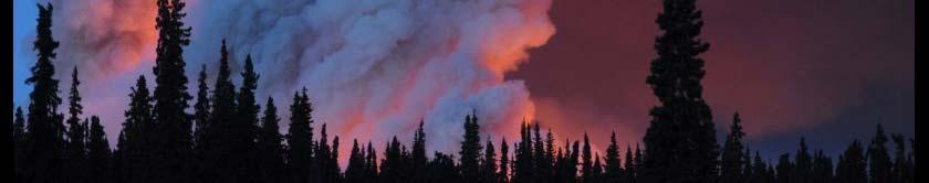
22 Satellite Applications Fire and Smoke Societal Impacts Leads to adverse environmental, social, and economic i impacts t Destruction to forest and rangeland vegetation, wildlife habitat, adverse impacts on recreation, tourism, water quality and supply Smoke emissions Affect air quality Major health hazard Major source of Greenhouse Gases 2013: 1,240,000 fires reported in the U.S. Caused 3,240 civilian deaths, 15,925 civilian injuries and $11.5 billion in property damage damage. Knowledge of short and long-term impacts of fire is essential for effective risk assessment, policy formation, disaster and resource management Capabilities Needed Detect small fires in remote areas Wide swath to ensure better revisit frequency q y No degradation near the edge of swath Estimate radiative power of fires Successfully use models to predict fire spread and forecast smoke JPSS Capabilities JPSS Capabilities Visible Infrared Imaging Radiometer Suite (VIIRS) Global coverage, wide swath and good quality detections along the entire scanline Improved resolution over heritage sensors: dedicated d at 750 ih i off fi VIIRS fi fire bband 750m without saturation fire radiative power Higher resolution detection from 375m bands DNB for enhance nighttime detection and characterization of small fires VIIRS imagery plume g y shows burn areas and smoke p from King Fire, CA (Sept 17, 2014) 22
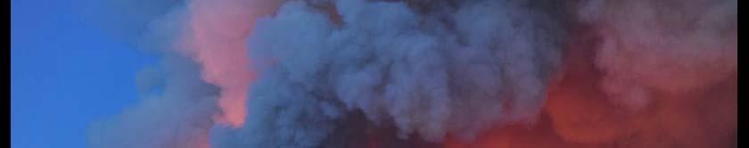
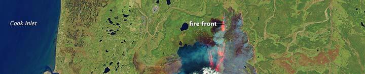
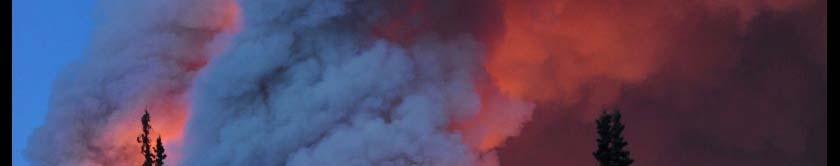
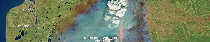
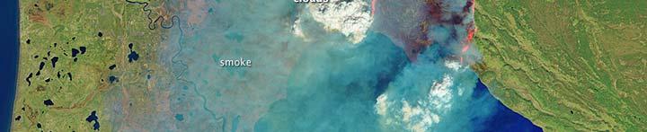

23 Integrating various satellite data is well recognized and emphasized Funny River Fire Alaska - May 20, 2014 VIIRS Landsat 8 (30 m)

 Landsat")


24 LANDSAT 8 (30 meter resolution vs VIIRS 375 meter resolution) Landsat 8 But Landsat has a 16 day repeat cycle VIIRS 375 meter resolution is adequate for fire behavior modeling predicting fire movement and smoke direction and speed. 24
25 Comparing MODIS (250m) to VIIRS (375m) Edge of Scan
26 Summary JPSS is a major contributor tib t to the global lobserving system. Suomi NPPinstrumentsare performingexceptionally exceptionally well!! Many applications will benefit and JPSS has a data exploitation i proving ground effort with iheach NOAA line office to improve product and services. International partnerships are essential. Observations coupled with modeling, data fusion, with the underpinning research, are essential for transforming observations to the products, applications, and services needed to address environmental impacts on society. 26


27 Thank You

28 Product Maturity Definition JPSS/GOES-R Data Product Validation Maturity Stages COMMON DEFINITIONS (Nominal Mission) 1. Beta o Product is minimally validated, and may still contain significant identified and unidentified errors. o Information/data from validation efforts can be used to make initial qualitative or very limited quantitative assessments regarding product fitness-for-purpose. o Documentation of product performance and identified product performance anomalies, including recommended remediation strategies, exists. 2. Provisional o Product performance has been demonstrated through analysis of a large, but still limited (i.e., not necessarily globally or seasonally representative) number of independent measurements obtained from selected locations, time periods, or field campaign efforts. o Product analyses are sufficient for qualitative, and limited quantitative, determination of product fitness-for-purpose. o Documentation of product performance, testing involving product fixes, identified product performance anomalies, including recommended remediation strategies, exists. o Product is recommended for operational use (user decision) and in scientific publications. 3. Validated o Product performance has been demonstrated over a large and wide range of representative conditions (i.e., global, seasonal). o Comprehensive documentation of product performance exists that includes all known product anomalies and their recommended remediation strategies for a full range of retrieval conditions and severity level. o Product analyses are sufficient for full qualitative and quantitative determination of product fitness-for-purpose. o Product is ready for operational use based on documented validation findings and user feedback. o Product validation, quality assurance, and algorithm stewardship continue through the lifetime of the instrument. May 2014, GOES-R, JPSS, and STAR Science Teams 28 28
Joint Polar Satellite System. 3 rd Post-EPS User Consultation Workshop Mike Haas
 3 rd Post-EPS User Consultation Workshop Mike Haas Overview Introduction - Policy Drivers - Management System Description - Space Segment - Ground Segment Partnerships Status Benefits 2 Introduction (Policy
JPSS GEONETCAST REQUIREMENTS DISCUSSION
 Joint Polar Satellite System (JPSS) JPSS GEONETCAST REQUIREMENTS DISCUSSION Mitch Goldberg Program Scientist Joint Polar Satellite System National Environmental Satellite, Data, and Information Service
JPSS Overview.
 JPSS Overview Mitch Goldberg, JPSS Program Scientist Joint Polar Satellite System National Environmental Satellite, Data, and Information Service National Oceanic and Atmospheric Administration September
Joint Polar Satellite System (JPSS)
") Joint Polar Satellite System (JPSS) United States Plans for Continuity of Operational Polar Weather and Environmental Observations Harry Cikanek, Director Mitch Goldberg, Program Scientist Joint Polar
Joint Polar Satellite System (JPSS) United States Plans for Continuity of Operational Polar Weather and Environmental Observations Harry Cikanek, Director Mitch Goldberg, Program Scientist Joint Polar
McIDAS support of Suomi-NPP /JPSS and GOES-R L2
 McIDAS support of Suomi-NPP /JPSS and GOES-R L2 William Straka III 1 Tommy Jasmin 1, Bob Carp 1 1 Cooperative Institute for Meteorological Satellite Studies, Space Science and Engineering Center, University
Interpretation of Polar-orbiting Satellite Observations. Atmospheric Instrumentation
 Interpretation of Polar-orbiting Satellite Observations Outline Polar-Orbiting Observations: Review of Polar-Orbiting Satellite Systems Overview of Currently Active Satellites / Sensors Overview of Sensor
F O U N D A T I O N A L C O U R S E
 F O U N D A T I O N A L C O U R S E December 6, 2018 Satellite Foundational Course for JPSS (SatFC-J) F O U N D A T I O N A L C O U R S E Introduction to Microwave Remote Sensing (with a focus on passive
Recent Update on MODIS C6 and VIIRS Deep Blue Aerosol Products
 Recent Update on MODIS C6 and VIIRS Deep Blue Aerosol Products N. Christina Hsu, Photo taken from Space Shuttle: Fierce dust front over Libya Corey Bettenhausen, Andrew M. Sayer, and Rick Hansell Laboratory
NOAA Cal/Val Progress Update
 NOAA Cal/Val Progress Update Xi Shao 1,2 and Changyong Cao 2 1. University of Maryland 2. NOAA/NESDIS/STAR With contributions from NOAA/NESDIS/STAR Scientists Presented at the WGCV-36, Shanghai, China,
Instrumentation planned for MetOp-SG
 Instrumentation planned for MetOp-SG Bill Bell Satellite Radiance Assimilation Group Met Office Crown copyright Met Office Outline Background - the MetOp-SG programme The MetOp-SG instruments Summary Acknowledgements:
Mitch Goldberg National Oceanic & Atmospheric Administration NOAA JPSS Program Scientist
 Mitch Goldberg National Oceanic & Atmospheric Administration NOAA JPSS Program Scientist JPSS consists of three satellites (Suomi NPP, JPSS-1, JPSS- 2), ground system and operations through 2025 JPSS mission
Satellite observation of atmospheric dust
 Satellite observation of atmospheric dust Taichu Y. Tanaka Meteorological Research Institute, Japan Meteorological Agency 11 April 2017, SDS WAS: Dust observation and modeling @WMO, Geneva Dust observations
EPS-SG Candidate Observation Missions
 EPS-SG Candidate Observation Missions 3 rd Post-EPS User Consultation Workshop Peter Schlüssel Slide: 1 EPS-SG benefits to activities of NMSs Main Payload High-Resolution Infrared Sounding Microwave Sounding
Status of VIIRS Reflective Solar Bands On-orbit Calibration and Performance
 EOS Status of VIIRS Reflective Solar Bands On-orbit Calibration and Performance X. Xiong 1, J. Fulbright 2, N. Lei 2, J. Sun 2, Z. Wang 2, and J. McIntire 2 1. NASA/GSFC, Greenbelt, MD 20771, USA 2. Sigma
Arctic Weather Every 10 Minutes: Design & Operation of ABI for PCW
 Arctic Weather Every 10 Minutes: Design and Operation of ABI for PCW Dr. Paul C. Griffith and Sue Wirth 31st Space Symposium, Technical Track, Colorado Springs, Colorado This document is not subject to
Future Opportunities of Using Microwave Data from Small Satellites for Monitoring and Predicting Severe Storms
 Future Opportunities of Using Microwave Data from Small Satellites for Monitoring and Predicting Severe Storms Fuzhong Weng Environmental Model and Data Optima Inc., Laurel, MD 21 st International TOV
COORDINATION GROUP FOR METEOROLOGICAL SATELLITES AND GOFC-GOLD
 Coordination Group for Meteorological Satellites - CGMS COORDINATION GROUP FOR METEOROLOGICAL SATELLITES AND GOFC-GOLD Mitch Goldberg, CGMS co-liaison to CGMS Working group 2 satellite data and products
The National Weather Service of the Future: Building a Weather-Ready Nation
 The of the Future: Building a Weather-Ready Nation Dr. Louis W. Uccellini Director, NOAA Assistant Administrator for Weather Services NCEP Production Suite Review December 2, 2014 Outline Building a Weather-Ready
Lecture 4b: Meteorological Satellites and Instruments. Acknowledgement: Dr. S. Kidder at Colorado State Univ.
 Lecture 4b: Meteorological Satellites and Instruments Acknowledgement: Dr. S. Kidder at Colorado State Univ. US Geostationary satellites - GOES (Geostationary Operational Environmental Satellites) US
NOAA Report. Mitch Goldberg. NOAA/NESDIS Center for Satellite Applications and Research
 NOAA Report Mitch Goldberg NOAA/NESDIS Center for Satellite Applications and Research NOAA JOINT POLAR SATELLITE PROGRAM Mission Support to NOAA Programs Ecosystems NOAA CoastWatch Program Real-time distribution
Impact of assimilating the VIIRS-based CrIS cloudcleared radiances on hurricane forecasts
 Impact of assimilating the VIIRS-based CrIS cloudcleared radiances on hurricane forecasts Jun Li @, Pei Wang @, Jinlong Li @, Zhenglong Li @, Jung-Rim Lee &, Agnes Lim @, Timothy J. Schmit #, and Mitch
NESDIS Polar (Region) Products and Plans. Jeff Key NOAA/NESDIS Madison, Wisconsin USA
 Products and Plans. Jeff Key NOAA/NESDIS Madison, Wisconsin USA") NESDIS Polar (Region) Products and Plans Jeff Key NOAA/NESDIS Madison, Wisconsin USA WMO Polar Space Task Group, 2 nd meeting, Geneva, 12 14 June 2012 Relevant Missions and Products GOES R ABI Fractional
NESDIS Polar (Region) Products and Plans Jeff Key NOAA/NESDIS Madison, Wisconsin USA WMO Polar Space Task Group, 2 nd meeting, Geneva, 12 14 June 2012 Relevant Missions and Products GOES R ABI Fractional
REVISION OF THE STATEMENT OF GUIDANCE FOR GLOBAL NUMERICAL WEATHER PREDICTION. (Submitted by Dr. J. Eyre)
") WORLD METEOROLOGICAL ORGANIZATION Distr.: RESTRICTED CBS/OPAG-IOS (ODRRGOS-5)/Doc.5, Add.5 (11.VI.2002) COMMISSION FOR BASIC SYSTEMS OPEN PROGRAMME AREA GROUP ON INTEGRATED OBSERVING SYSTEMS ITEM: 4 EXPERT
WORLD METEOROLOGICAL ORGANIZATION Distr.: RESTRICTED CBS/OPAG-IOS (ODRRGOS-5)/Doc.5, Add.5 (11.VI.2002) COMMISSION FOR BASIC SYSTEMS OPEN PROGRAMME AREA GROUP ON INTEGRATED OBSERVING SYSTEMS ITEM: 4 EXPERT
Preparing for NOAA s Next Generation GOES-R & JPSS
 Preparing for NOAA s Next Generation GOES-R & JPSS Mark Paese Deputy Assistant Administrator NOAA Environmental Satellite & Information Service (NESDIS) WMO Cg-17: Ensuring User Readiness for New Generation
Unidata Policy Committee NOAA/NWS Update
 Unidata Policy Committee NOAA/NWS Update October 27, 2011 LeRoy Spayd Chief Training Division Office of Climate, Water, and Weather Services NOAA s National Weather Service 1 2 Outline NOAA Budget NOAA
The Transition of Atmospheric Infrared Sounder Total Ozone Products to Operations
 The Transition of Atmospheric Infrared Sounder Total Ozone Products to Operations Emily Berndt 1, Bradley Zavodsky 2, Gary Jedlovec 2 1 NASA Postdoctoral Program Marshall Space Flight Center, Huntsville,
NOAA Operational Satellites -Program Update-
 NOAA Operational Satellites -Program Update- (GOES-R Series, JPSS & COSMIC-2) Briefing to the Expert Team on Satellite Systems (ET-SAT-11) Geneva, 4-6 April 2017 Sid Ahmed Boukabara NOAA/NESDIS Center
CMA Consideration on early-morning orbit satellite
 CMA Consideration on early-morning orbit satellite National Satellite Meteorological Center,CMA Yang Jun CGMS 40 in Lugano, 5-9 Nov., 2012 Outline Background Gap analysis on the sounding data coverage
NOAA Report. Hal Bloom Mitch Goldberg NOAA/NESDIS
 NOAA Report Hal Bloom Mitch Goldberg NOAA/NESDIS Summary of Major Events at NESDIS (of interest to ITSC) NOAA/NASA addressing NPOESS Climate Sensors Letter of agreement signed with JAXA on GCOM interagency
The NOAA Unique CrIS/ATMS Processing System (NUCAPS): first light retrieval results
: first light retrieval results") The NOAA Unique CrIS/ATMS Processing System (NUCAPS): first light retrieval results A. Gambacorta (1), C. Barnet (2), W.Wolf (2), M. Goldberg (2), T. King (1), X. Ziong (1), N. Nalli (3), E. Maddy (1),
The NOAA Unique CrIS/ATMS Processing System (NUCAPS): first light retrieval results A. Gambacorta (1), C. Barnet (2), W.Wolf (2), M. Goldberg (2), T. King (1), X. Ziong (1), N. Nalli (3), E. Maddy (1),
The NOAA/NESDIS/STAR IASI Near Real-Time Product Processing and Distribution System
 The NOAA/NESDIS/STAR Near Real-Time Product Processing and Distribution System W. Wolf 2, T. King 1, Z. Cheng 1, W. Zhou 1, H. Sun 1, P. Keehn 1, L. Zhou 1, C. Barnet 2, and M. Goldberg 2 1 QSS Group Inc,
Operational Uses of Bands on the GOES-R Advanced Baseline Imager (ABI) Presented by: Kaba Bah
 Presented by: Kaba Bah") Operational Uses of Bands on the GOES-R Advanced Baseline Imager (ABI) Presented by: Kaba Bah Topics: Introduction to GOES-R & ABI ABI individual bands Use of band differences ABI derived products Conclusions
Operational Uses of Bands on the GOES-R Advanced Baseline Imager (ABI) Presented by: Kaba Bah Topics: Introduction to GOES-R & ABI ABI individual bands Use of band differences ABI derived products Conclusions
Using the NOAA Unique CrIS/ATMS Processing System (NUCAPS) to explore hyper spectral sounding capabilities during extreme events
 to explore hyper spectral sounding capabilities during extreme events") Using the NOAA Unique CrIS/ATMS Processing System (NUCAPS) to explore hyper spectral sounding capabilities during extreme events Antonia Gambacorta (1), Chris Barnet (1),Mitch Goldberg (2), Ryan Spackman
Using the NOAA Unique CrIS/ATMS Processing System (NUCAPS) to explore hyper spectral sounding capabilities during extreme events Antonia Gambacorta (1), Chris Barnet (1),Mitch Goldberg (2), Ryan Spackman
CGMS Baseline. Sustained contributions to the Global Observing System. Endorsed by CGMS-46 in Bengaluru, June 2018
 CGMS Baseline Sustained contributions to the Global Observing System Best Practices for Achieving User Readiness for New Meteorological Satellites Endorsed by CGMS-46 in Bengaluru, June 2018 CGMS/DOC/18/1028862,
Observations Team: Satellite Observation Update. John Knaff NOAA/NESDIS Regional and Mesoscale Meteorology Branch
 Observations Team: Satellite Observation Update John Knaff NOAA/NESDIS Regional and Mesoscale Meteorology Branch 1 FY12 Satellite Milestones: i. CIRA/RAMMB continue maintaining and populating real-time
Lecture 19: Operational Remote Sensing in Visible, IR, and Microwave Channels
 MET 4994 Remote Sensing: Radar and Satellite Meteorology MET 5994 Remote Sensing in Meteorology Lecture 19: Operational Remote Sensing in Visible, IR, and Microwave Channels Before you use data from any
Improving Numerical Weather Forecasting for Ghana/West Africa
 Improving Numerical Weather Forecasting for Ghana/West Africa Amos T. Kabo-bah, PhD Head, Earth Observation Research and Innovation Centre University of Energy and Natural Resources Sunyani Ghana/West
Status report on current and future satellite systems by EUMETSAT Presented to CGMS-44, Plenary session, agenda item D.1
 Status report on current and future satellite systems by EUMETSAT Presented to CGMS-44, Plenary session, agenda item D.1 CGMS-44-EUMETSAT-WP-19.ppt, version 1 (# 859110), 8 June 2016 MISSION PLANNING YEAR...
An Overview of NOAA s Satellite, Data, and Information Stewardship Program
 An Overview of NOAA s Satellite, Data, and Information Stewardship Program John J. Bates and Mitch Goldberg National Oceanic and Atmospheric Administration National Environmental Satellite Data and Information
GOES-R. Getting ready for the next generation earth observing system. Yuguang He AER April 10, 2015
 GOES-R Getting ready for the next generation earth observing system Yuguang He AER April 10, 2015 Outline! AER in research and applica0ons! AER on GOES- R! GOES- R: the next genera0on! Ge:ng ready for
Feature-tracked 3D Winds from Satellite Sounders: Derivation and Impact in Global Models
 Feature-tracked 3D Winds from Satellite Sounders: Derivation and Impact in Global Models David Santek 1, A.-S. Daloz 1, S. Tushaus 1, M. Rogal 1, W. McCarty 2 1 Space Science and Engineering Center/University
NOAA Direct Broadcast Real-Time Network Status
 NOAA Direct Broadcast Real-Time Network Status Liam Gumley (CIMSS/SSEC/UW-Madison) Mitch Goldberg (JPSS/NOAA) WMO DBNET Operators Meeting Sept 2016 Overview NOAA antennas for Honolulu, Madison, Miami,
Jun Mitch Goldberg %, Pei Timothy J. Schmit &, Jinlong Zhenglong and Agnes
 Progress on the assimilation of advanced IR sounder radiances in cloudy skies Jun Li @, Mitch Goldberg %, Pei Wang @#, Timothy J. Schmit &, Jinlong Li @, Zhenglong Li @, and Agnes Lim @ @CIMSS, University
Direct Readout at the Meteorological Service of Canada
 Direct Readout at the Meteorological Service of Canada CSPP Users Meeting 2015 Darmstadt, Germany April 14-16, 2015 David Bradley Manager, Earth Observation and Geomatics Meteorological Service of Canada
The use of Direct Broadcast Processing System in Poland
 The use of Direct Broadcast Processing System in Poland B.Łapeta, P.Struzik Satellite Remote Sensing Department, Institute of Meteortology and Water Management National Reasearch Institute About IMWM-NRI
EUMETSAT STATUS AND PLANS
 1 EUM/TSS/VWG/15/826793 07/10/2015 EUMETSAT STATUS AND PLANS François Montagner, Marine Applications Manager, EUMETSAT WMO Polar Space Task Group 5 5-7 October 2015, DLR, Oberpfaffenhofen PSTG Strategic
A two-season impact study of the Navy s WindSat surface wind retrievals in the NCEP global data assimilation system
 A two-season impact study of the Navy s WindSat surface wind retrievals in the NCEP global data assimilation system Li Bi James Jung John Le Marshall 16 April 2008 Outline WindSat overview and working
P4.23 INTRODUCING THE GOES IMAGER CLEAR-SKY BRIGHTNESS TEMPERATURE (CSBT) PRODUCT
 PRODUCT") P4.23 INTRODUCING THE GOES IMAGER CLEAR-SKY BRIGHTNESS TEMPERATURE (CSBT) PRODUCT Anthony J. Schreiner Cooperative Institute for Meteorological Satellite Studies (CIMSS) University of Wisconsin-Madison
P4.23 INTRODUCING THE GOES IMAGER CLEAR-SKY BRIGHTNESS TEMPERATURE (CSBT) PRODUCT Anthony J. Schreiner Cooperative Institute for Meteorological Satellite Studies (CIMSS) University of Wisconsin-Madison
Improving Tropical Cyclone Forecasts by Assimilating Microwave Sounder Cloud-Screened Radiances and GPM precipitation measurements
 Improving Tropical Cyclone Forecasts by Assimilating Microwave Sounder Cloud-Screened Radiances and GPM precipitation measurements Hyojin Han a, Jun Li a, Mitch Goldberg b, Pei Wang a,c, Jinlong Li a,
Application of Himawari-8 AHI Data to the GOES-R Rainfall Rate Algorithm
 Application of Himawari-8 AHI Data to the GOES-R Rainfall Rate Algorithm Yaping Li 1, Robert Kuligowski 2 and Yan Hao 1 1. IMSG at NOAA/NESDIS/STAR 2. NOAA/NESDIS/STAR, College Park, MD 1 GOES-R Baseline
MONITORING WEATHER AND CLIMATE FROM SPACE
 MONITORING WEATHER AND CLIMATE FROM SPACE EUMETSAT Report on New Services Anders Meier Soerensen New X/L-band antenna, Greenland Athens: New 3.0 m L/X-band antenna New 2.4 m L/Xband antenna Installations
Assimilation of CrIS and ATMS Radiances in HWRF to Improve Hurricane/Typhoon Forecasts
 Assimilation of CrIS and ATMS Radiances in HWRF to Improve Hurricane/Typhoon Forecasts Fuzhong Weng 1, Xiaolei Zou 2, Lin Lin 3, Banglin Zhang 4, Vijay Tallaparagada 4 and Mitch Goldberg 5 1. NOAA Center
The Ozone Mapping and Profiler Suite (OMPS): From SNPP to JPSS-1
: From SNPP to JPSS-1") The Ozone Mapping and Profiler Suite (OMPS): From SNPP to JPSS-1 *C. Pan 1 and F. Weng 2 Curtsey of BATC Aerosol Index * 1 ESSIC, University of Maryland, College Park, MD 20740; 2 NOAA NESDIS/STAR, College
The Ozone Mapping and Profiler Suite (OMPS): From SNPP to JPSS-1 *C. Pan 1 and F. Weng 2 Curtsey of BATC Aerosol Index * 1 ESSIC, University of Maryland, College Park, MD 20740; 2 NOAA NESDIS/STAR, College
Some NOAA Products that Address PSTG Satellite Observing Requirements. Jeff Key NOAA/NESDIS Madison, Wisconsin USA
 Some NOAA Products that Address PSTG Satellite Observing Requirements Jeff Key NOAA/NESDIS Madison, Wisconsin USA WMO Polar Space Task Group, 4 th meeting, Greenbelt, 30 September 2014 Relevant Missions
EUMETSAT SAF NETWORK. Lothar Schüller, EUMETSAT SAF Network Manager
 1 EUMETSAT SAF NETWORK Lothar Schüller, EUMETSAT SAF Network Manager EUMETSAT ground segment overview METEOSAT JASON-2 INITIAL JOINT POLAR SYSTEM METOP NOAA SATELLITES CONTROL AND DATA ACQUISITION FLIGHT
Radio Frequency Earth Science
 Radio Frequency Earth Science Overview for Committee On Radio Frequency (CORF) National Academy of Science National Research Council April 27, 2005 Bill.Watson@NASA.Gov Program Executive for Ground Networks
Introducing VIIRS Aerosol Products
 1 Introducing VIIRS Aerosol Products Shobha Kondragunta NOAA/NESDIS Center for Satellite Applications and Research VIIRS Aerosol Cal/Val Team 2 Name Organization Major Task Kurt F. Brueske IIS/Raytheon
4/23/2014. Radio Occultation as a Gap Filler for Infrared and Microwave Sounders Richard Anthes Presentation to Joshua Leiling and Shawn Ward, GAO
 Radio Occultation as a Gap Filler for Infrared and Microwave Sounders Richard Anthes Presentation to Joshua Leiling and Shawn Ward, GAO 1 RICHARD ANTHES is President Emeritus of the University Corporation
A New Microwave Snow Emissivity Model
 A New Microwave Snow Emissivity Model Fuzhong Weng 1,2 1. Joint Center for Satellite Data Assimilation 2. NOAA/NESDIS/Office of Research and Applications Banghua Yan DSTI. Inc The 13 th International TOVS
United States Multi-Hazard Early Warning System
 United States Multi-Hazard Early Warning System Saving Lives Through Partnership Lynn Maximuk National Weather Service Director, Central Region Kansas City, Missouri America s s Weather Enterprise: Protecting
A 2016 CEOS Chair Initiative. Non-meteorological Applications for Next Generation Geostationary Satellites
 A 2016 CEOS Chair Initiative Committee on Earth Observation Satellites Non-meteorological Applications for Next Generation Geostationary Satellites Co-chaired by EUMETSAT (Holmlund), CSIRO (Schroeder),
VALIDATION OF INSAT-3D DERIVED RAINFALL. (Submitted by Suman Goyal, IMD) Summary and Purpose of Document
 Summary and Purpose of Document") WORLD METEOROLOGICAL ORGANIZATION COMMISSION FOR BASIC SYSTEMS OPEN PROGRAMME AREA GROUP ON INTEGRATED OBSERVING SYSTEMS INTER-PROGRAMME EXPERT TEAM ON SATELLITE UTILIZATION AND PRODUCTS SECOND SESSION
WORLD METEOROLOGICAL ORGANIZATION COMMISSION FOR BASIC SYSTEMS OPEN PROGRAMME AREA GROUP ON INTEGRATED OBSERVING SYSTEMS INTER-PROGRAMME EXPERT TEAM ON SATELLITE UTILIZATION AND PRODUCTS SECOND SESSION
IASI Level 2 Product Processing
 IASI Level 2 Product Processing Dieter Klaes for Peter Schlüssel Arlindo Arriaga, Thomas August, Xavier Calbet, Lars Fiedler, Tim Hultberg, Xu Liu, Olusoji Oduleye Page 1 Infrared Atmospheric Sounding
Behind the Climate Prediction Center s Extended and Long Range Outlooks Mike Halpert, Deputy Director Climate Prediction Center / NCEP
 Behind the Climate Prediction Center s Extended and Long Range Outlooks Mike Halpert, Deputy Director Climate Prediction Center / NCEP September 2012 Outline Mission Extended Range Outlooks (6-10/8-14)
Comparison of NASA AIRS and MODIS Land Surface Temperature and Infrared Emissivity Measurements from the EOS AQUA platform
 Comparison of NASA AIRS and MODIS Land Surface Temperature and Infrared Emissivity Measurements from the EOS AQUA platform Robert Knuteson, Steve Ackerman, Hank Revercomb, Dave Tobin University of Wisconsin-Madison
Satellite-derived Wind, Cloud, and Surface Products at Direct Broadcast Sites in the Antarctic and Arctic
 Satellite-derived Wind, Cloud, and Surface Products at Direct Broadcast Sites in the Antarctic and Arctic William Straka III +, Jeff Key*, Dave Santek +, Matthew Lazzara #, Liam Gumley +, Kathy Strabala
Climate Modeling Research & Applications in Wales. John Houghton. C 3 W conference, Aberystwyth
 Climate Modeling Research & Applications in Wales John Houghton C 3 W conference, Aberystwyth 26 April 2011 Computer Modeling of the Atmosphere & Climate System has revolutionized Weather Forecasting and
STATUS OF JAPANESE METEOROLOGICAL SATELLITES AND RECENT ACTIVITIES OF MSC
 STATUS OF JAPANESE METEOROLOGICAL SATELLITES AND RECENT ACTIVITIES OF MSC Daisaku Uesawa Meteorological Satellite Center, Japan Meteorological Agency Abstract MTSAT-1R is the current operational Japanese
EUMETSAT SAF NETWORK. Lothar Schüller, EUMETSAT SAF Network Manager
 1 EUMETSAT SAF NETWORK Lothar Schüller, EUMETSAT SAF Network Manager EUMETSAT ground segment overview METEOSAT JASON-2 INITIAL JOINT POLAR SYSTEM METOP NOAA SATELLITES CONTROL AND DATA ACQUISITION FLIGHT
APPENDIX 2 OVERVIEW OF THE GLOBAL PRECIPITATION MEASUREMENT (GPM) AND THE TROPICAL RAINFALL MEASURING MISSION (TRMM) 2-1
 AND THE TROPICAL RAINFALL MEASURING MISSION (TRMM) 2-1") APPENDIX 2 OVERVIEW OF THE GLOBAL PRECIPITATION MEASUREMENT (GPM) AND THE TROPICAL RAINFALL MEASURING MISSION (TRMM) 2-1 1. Introduction Precipitation is one of most important environmental parameters.
APPENDIX 2 OVERVIEW OF THE GLOBAL PRECIPITATION MEASUREMENT (GPM) AND THE TROPICAL RAINFALL MEASURING MISSION (TRMM) 2-1 1. Introduction Precipitation is one of most important environmental parameters.
Next generation of EUMETSAT microwave imagers and sounders: new opportunities for cloud and precipitation retrieval
 Next generation of EUMETSAT microwave imagers and sounders: new opportunities for cloud and precipitation retrieval Christophe Accadia, Sabatino Di Michele, Vinia Mattioli, Jörg Ackermann, Sreerekha Thonipparambil,
Advancing Environmental Intelligence via Next-Generation Satellite Observations
 Advancing Environmental Intelligence via Next-Generation Satellite Observations Steven D. Miller Cooperative Institute for Research in the Atmosphere 11 th NOAA/NESDIS CoRP Science Symposium 16 September
Tracking On-orbit Radiometric Accuracy and Stability of Suomi NPP VIIRS using Extended Low Latitude SNOs
 Tracking On-orbit Radiometric Accuracy and Stability of Suomi NPP VIIRS using Extended Low Latitude SNOs Sirish Uprety a Changyong Cao b Slawomir Blonski c Xi Shao c Frank Padula d a CIRA, Colorado State
Course outline, objectives, workload, projects, expectations
 Course outline, objectives, workload, projects, expectations Introductions Remote Sensing Overview Elements of a remote sensing observing system 1. platform (satellite, surface, etc) 2. experimental design
The Challenge of. Guy Brasseur
 The Challenge of Monitoring and Predicting Chemical Weather Guy Brasseur Introduction: What is Chemical Weather? What is Chemical Weather? Local, regional, and global distributions of important trace gases
Status of Operational Suomi NPP Algorithms. Bonnie Reed JPSS Ground Project Data Products and Algorithms
 Status of Operational Suomi NPP Algorithms Bonnie Reed JPSS Ground Project Data Products and Algorithms Outline Overview of SNPP Data Products Algorithm Validation Process Algorithm Status Algorithm Maturity
The CEOS Atmospheric Composition Constellation (ACC) An Example of an Integrated Earth Observing System for GEOSS
 An Example of an Integrated Earth Observing System for GEOSS") The CEOS Atmospheric Composition Constellation (ACC) An Example of an Integrated Earth Observing System for GEOSS Presentation Authors: E. Hilsenrath NASA, C. Zehner ESA, J. Langen ESA, J. Fishman NASA
The CEOS Atmospheric Composition Constellation (ACC) An Example of an Integrated Earth Observing System for GEOSS Presentation Authors: E. Hilsenrath NASA, C. Zehner ESA, J. Langen ESA, J. Fishman NASA
VIIRS SDR Cal/Val: S-NPP Update and JPSS-1 Preparations
 VIIRS SDR Cal/Val: S-NPP Update and JPSS-1 Preparations VIIRS SDR Cal/Val Posters: Xi Shao Zhuo Wang Slawomir Blonski ESSIC/CICS, University of Maryland, College Park NOAA/NESDIS/STAR Affiliate Spectral
Spaceborne Wind Lidar Observations by Aeolus Data Products and Pre-Launch Validation with an Airborne Instrument
 DRAGON 3 Project ID 10532 Cal/Val Spaceborne Wind Lidar Observations by Aeolus Data Products and Pre-Launch Validation with an Airborne Instrument Reitebuch Oliver, Lemmerz Christian, Marksteiner Uwe,
CGMS Baseline In response to CGMS action/recommendation A45.01 HLPP reference: 1.1.8
 Prepared by WGIII Agenda Item: 7.1 Discussed in WGIII CGMS Baseline In response to CGMS action/recommendation A45.01 HLPP reference: 1.1.8 In CGMS-45, Working Group III agreed to hold a review of the CGMS
Space Studies Board Meeting Mary E. Kicza
 Space Studies Board Meeting Mary E. Kicza Assistant Administrator for Satellites and Information Services May 14, 2009 1 Summary Budget Update FY 2009 Stimulus (ARRA) FY 2009 Omnibus FY 2010 President
Introduction of the new Suomi-NPP VIIRS Aerosol Products
 Introduction of the new Suomi-NPP VIIRS Aerosol Products Jingfeng Huang 1,2, Ho-Chun Huang 1,2 Istvan Laszlo 2, Shobha Kondragunta 2 Hongqing Liu 2,3, Lorraine Remer 4, Hai Zhang 2,3 1 CICS-MD/ESSIC/UMD
History of Aerosol Remote Sensing. Mark Smithgall Maria Zatko 597K Spring 2009
 History of Aerosol Remote Sensing Mark Smithgall Maria Zatko 597K Spring 2009 Aerosol Sources Anthropogenic Biological decomposition from fertilizer and sewage treatment (ex. ammonium) Combustion of fossil
Procedures to Characterize Sounding Profiles using Conventional and Reference/Dedicated Observations --- NPROVS & NPROVS+
 Procedures to Characterize Sounding Profiles using Conventional and Reference/Dedicated Observations --- NPROVS & NPROVS+ Tony Reale 1 and Bomin Sun 2 and many others 1 STAR/NESDIS/NOAA 2 IMSG at STAR/NESDIS/NOAA
National Aeronautics and Space Administration. Earth Day is everyday at NASA. activity booklet
 National Aeronautics and Space Administration Earth Day is everyday at NASA activity booklet Earth Day is everyday at NASA NASA s Fleet of Earth Observing Satellites ACRIMSAT Landsat 7 Aqua SORCE Terra
Monitoring Air Pollution from Space
 Monitoring Air Pollution from Space Media Regional Training Workshop 16 th Nov 20 th Nov 2015 Shreta Ghimire International Centre for Integrated Mountain Development Kathmandu, Nepal Why do we study air
The current status of FY-3D
 The current status of FY-3D Xiang Fang National Satellite Meteorological Center, China Meteorological Administration (NSMC/CMA) OUTLINE Overview Key instruments onboard FY-3D Products and data service
GCOM-W1 now on the A-Train
 GCOM-W1 now on the A-Train GCOM-W1 Global Change Observation Mission-Water Taikan Oki, K. Imaoka, and M. Kachi JAXA/EORC (& IIS/The University of Tokyo) Mini-Workshop on A-Train Science, March 8 th, 2013
Introduction of the new Suomi NPP VIIRS Aerosol Products
 Introduction of the new Suomi NPP VIIRS Aerosol Products Jingfeng Huang 1,2, Ho Chun Huang 1,2 Istvan Laszlo 2, Shobha Kondragunta 2 Hongqing Liu 2,3, Lorraine Remer 4, Hai Zhang 2,3 1 CICS-MD/ESSIC/UMD
Performance and Application of CSPP/IMAPP in East China
 Performance and Application of CSPP/IMAPP in East China Yan-An Liu 1, Wei Gao 1, Runhe Shi 1, Allen Huang 2, Kathy Strabala 2, Liam Gumley 2 1. East China Normal University 2. University of Wisconsin-Madison
The Use of Hyperspectral Infrared Radiances In Numerical Weather Prediction
 The Use of Hyperspectral Infrared Radiances In Numerical Weather Prediction J. Le Marshall 1, J. Jung 1, J. Derber 1, T. Zapotocny 2, W. L. Smith 3, D. Zhou 4, R. Treadon 1, S. Lord 1, M. Goldberg 1 and
NOAA s National Weather Service. National Weather Service
 NOAA s National Weather Service Serving the Nation s Environmental Forecasting Needs Lynn Maximuk Regional Director National Weather Service Central Region Headquarters Kansas City, Missouri America s
On the assimilation of hyperspectral infrared sounder radiances in cloudy skies
 On the assimilation of hyperspectral infrared sounder radiances in cloudy skies Jun Li 1, Pei Wang 1, Zhenglong Li 1, Jinlong Li 1 and Mitchell D. Goldberg 2 1 Cooperative Institute for Meteorological
Contribution to global Earth observation from satellites
 Contribution to global Earth observation from satellites - JAXA s Earth Observation strategy - April 16, 2008 Makoto Kajii Japan Aerospace Exploration Agency Earth Observation Summits and GEOSS 1 st EO
Atmospheric Soundings of Temperature, Moisture and Ozone from AIRS
 Atmospheric Soundings of Temperature, Moisture and Ozone from AIRS M.D. Goldberg, W. Wolf, L. Zhou, M. Divakarla,, C.D. Barnet, L. McMillin, NOAA/NESDIS/ORA Oct 31, 2003 Presented at ITSC-13 Risk Reduction
Arising from headwaters around Mount Robson in the Rocky Mountains, the Fraser River starts as a fastmoving stream. The river angles northward around
 Arising from headwaters around Mount Robson in the Rocky Mountains, the Fraser River starts as a fastmoving stream. The river angles northward around the Columbia Mountains, picking up so much sediment
Status of the NOAA Unique Combined Atmospheric Processing System (NUCAPS)
") Status of the NOAA Unique Combined Atmospheric Processing System (NUCAPS) Antonia Gambacorta, Nick Nalli, Flavio Iturbide-Sanchez, Changyi Tan, Kexin Zhang, Mike Wilson, Callyn Bloch, Juying Warner, Tom
Status of the NOAA Unique Combined Atmospheric Processing System (NUCAPS) Antonia Gambacorta, Nick Nalli, Flavio Iturbide-Sanchez, Changyi Tan, Kexin Zhang, Mike Wilson, Callyn Bloch, Juying Warner, Tom
WORLD S CHOICE FOR GEO IMAGING. Advanced Baseline Imager (ABI)
") WORLD S CHOICE FOR GEO IMAGING Advanced Baseline Imager (ABI) MARKET-LEADING EXPERTISE DELIVERS BEST-IN-CLASS WEATHER IMAGING In cases of extreme weather such as hurricanes, typhoons, blizzards and tornadoes,
WORLD S CHOICE FOR GEO IMAGING Advanced Baseline Imager (ABI) MARKET-LEADING EXPERTISE DELIVERS BEST-IN-CLASS WEATHER IMAGING In cases of extreme weather such as hurricanes, typhoons, blizzards and tornadoes,
The current status of FY-3D. (Submitted by Xiang Fang, CMA) Summary and Purpose of Document
 Summary and Purpose of Document") WORLD METEOROLOGICAL ORGANIZATION COMMISSION FOR BASIC SYSTEMS OPEN PROGRAMME AREA GROUP ON INTEGRATED OBSERVING SYSTEMS INTER-PROGRAMME EXPERT TEAM ON SATELLITE UTILIZATION AND PRODUCTS FOURTH SESSION
WORLD METEOROLOGICAL ORGANIZATION COMMISSION FOR BASIC SYSTEMS OPEN PROGRAMME AREA GROUP ON INTEGRATED OBSERVING SYSTEMS INTER-PROGRAMME EXPERT TEAM ON SATELLITE UTILIZATION AND PRODUCTS FOURTH SESSION
The Copernicus Climate Change (C3) service: State of play
 service: State of play") Enterprise and Industry The Copernicus Climate Change (C3) service: State of play B. Pinty (a) & J-N. Thépaut (b) (a) Copernicus G.2 unit (b) ECMWF CCI October2014 Legal frame & MS consultations Publica6on
Enterprise and Industry The Copernicus Climate Change (C3) service: State of play B. Pinty (a) & J-N. Thépaut (b) (a) Copernicus G.2 unit (b) ECMWF CCI October2014 Legal frame & MS consultations Publica6on