Jet Propulsion Laboratory California Institute of Technology. ASO In The Tuolumne: 3 Years Of Basin SWE, and PRMS Assimilation Results
|
|
|
- Dylan Riley
- 5 years ago
- Views:
Transcription


1 ASO In The Tuolumne: 3 Years Of Basin SWE, and PRMS Assimilation Results Bruce J. McGurk and Thomas H. Painter & ASO Team Hydroclimate Workshop, 8 Oct. 2015


,")
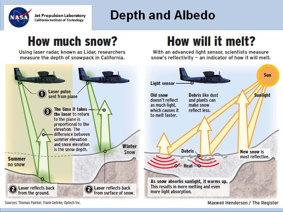
2 Need frequent, dense SWE data at all elevations Manual measurement of SWE (snow water equivalent), started in the Sierra Nevada in 1910


3 Snow Measurement - Tuolumne 17 snow courses, 5 below 7000 ft, 3 > 9000 ft Only 8 snow sensors, 5 co-located 80 sq ft/sensor, 20 sq ft/course =.06 millionth of a percent of the basin is measured

4 Landsat Snowcover, 1/18/2015

5 MODSCAG from MODIS, 3/05/15
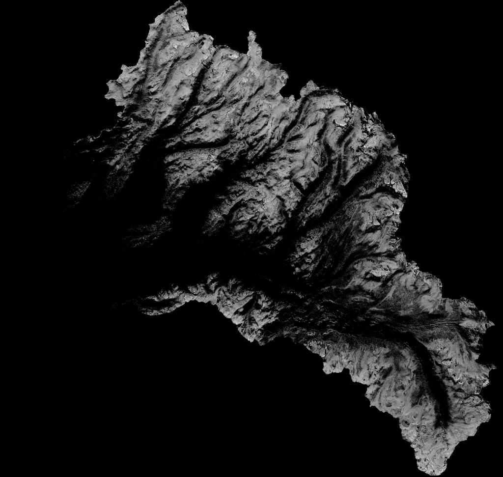
6

7 ASO scan configuration: Riegl Q1560 scanning LiDAR, Itres CASI-1500 imaging spectrometer
8

9 ASO footprint, Merced Basin, 3/05/2015

10 LiDAR & Spectrometer Pipeline

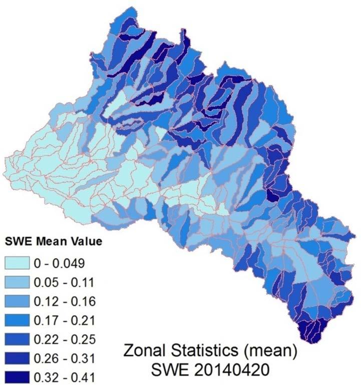
11 ASO SWE - Tuolumne Basin 2014

12 Jump to folder! Tuolumne basin SWE video
13 Basin SWE, Inflow, & Storage , Tuolumne ASO Basin SWE, HH Inflow & Storage 4, ,000 4,000 SWE & Storage (Acre Feet) 300, , , , ,000 Basin SWE(AF) HH Storage(AF) HH Capacity(AF) HH inflow cfs 3,500 3,000 2,500 2,000 1,500 1,000 Inflow (cfs) 50,
14 Basin SWE, Inflow, & Storage , Tuolumne ASO Basin SWE, HH Inflow & Storage Basin SWE (AF) 3, ,000 HH Storage (AF) 3,000 SWE & Storage (AF) 300, , , , ,000 HH Capacity (AF) HH inflow cfs 2,500 2,000 1,500 1,000 Inflow (cfs) 50,
15 Basin SWE, Inflow, & Storage , , , Tuolumne ASO Basin SWE, HH Inflow & Storage Basin SWE (AF) HH Storage (AF) HH Capacity (AF) HH inflow cfs 2,400 1,900 SWE & Storage (AF) 250, , , ,000 50,000 1, Inflow (cfs) 0-100
16 3 Years of ASO SWE and HH Inflow Rates ASO HH Basin SWE & Inflow - Tuolumne vs 2014 vs 2015 ASO Basin SWE (AF) 225, , , , , ,000 75, Basin SWE (AF) 2014 Basin SWE (AF) 2015 Basin SWE (AF) 2013 HH Inflow (cfs) 2014 HH Inflow (cfs) 2015 HH Inflow (cfs) 10,000 9,000 8,000 7,000 6,000 5,000 4,000 3,000 Hetch Hetchy Inflow (cfs) 50,000 2,000 25,000 1, /16 2/23 3/2 3/9 3/16 3/23 3/30 4/6 4/13 4/20 4/27 5/4 5/11 5/18 5/25 6/1 6/8 6/15

17 ASO SWE Here USGS PRMS Hydrologic Budget


")

18 Hetch Hetchy Basin Stations & PRMS HRUs SWE (Meters)

19 PRMS Screens
20 Obs. HH Inflow (cfs) Raw PRMS basin_cfs ASO PRMS basin_cfs CNRFC basin_cfs 5/15/2013 5/16/2013 5/17/2013 5/18/2013 5/19/2013 5/20/2013 5/21/2013 5/22/2013 5/23/2013 5/24/2013 5/25/2013 5/26/2013 5/27/2013 5/28/2013 5/29/2013 5/30/2013 5/31/2013 6/1/2013 6/2/2013 6/3/2013 6/4/2013 6/5/2013 6/6/2013 6/7/2013 6/8/2013 6/9/2013 6/10/2013 6/11/2013 6/12/2013 6/13/2013 6/14/2013 6/15/2013 6/16/2013
21 4,000.0 Jet Propulsion Laboratory 2014 Hetch Hetchy Observed & Forecasted Inflow 5/17 PRMS Forecast 3, /17 ASO Forecast HH Estimated Inflow 3, ,500.0 Inflow (cfs) 2, , , /1/2014 5/2/2014 5/3/2014 5/4/2014 5/5/2014 5/6/2014 5/7/2014 5/8/2014 5/9/2014 5/10/20 5/11/20 5/12/20 5/13/20 ASO SWE Results Assimilated into PRMS 5/14/20 5/15/20 5/16/20 5/17/20 5/18/20 5/19/20 5/20/20 5/21/20 5/22/20 5/23/20 5/24/20 5/25/20 5/26/20 5/27/20 5/28/20 5/29/20 5/30/20 5/31/20 6/1/2014
22 2014 Hetch Hetchy Observed & Forecasted Inflow 3, /27 PRMS Forecast 3, /27 ASO Forecast HH Estimated Inflow 2,500.0 Inflow (cfs) 2, , , ASO SWE Results Assimilated into PRMS
23 2014 Hetch Hetchy Observed & Forecasted Inflow 3,500 5/31 PRMS Forecast 3,000 2,500 5/31 ASO Forecast HH Observed Inflow Inflow (cfs) 2,000 1,500 1, ASO SWE Results Assimilated into PRMS
24 2,500 2, Hetch Hetchy Observed & Forecasted Inflow ASO SWE Results Assimilated into PRMS Inflow (cfs) 1,500 1, /09 PRMS Forecast 4/09 ASO Forecast HH Estimated Inflow
25 2,500 2, Hetch Hetchy Observed & Forecasted Inflow ASO SWE Results Assimilated into PRMS Inflow (cfs) 1,500 1, /15 PRMS Forecast 4/15 ASO Forecast HH Estimated Inflow
26 Modeling Needs ASO results are gridded (3-50 m 2 ), and PRMS polygons (HRU s) are 1,000 to 10,000 acres. Further discretization is desired. Advanced snowmelt routines now exist that use long- and shortwave radiation. Current version of PRMS uses a temperature-index algorithm, calibrated with shortwave radiation records. Albedo (percentage of reflected shortwave insolation) is measured by ASO, but is not able to be input into PRMS. Assimilation of ASO Data is possible, but best procedure that guarantees stable predictions has not been identified. Good model predictions depend on good upper elevation forcing data, and most basins have minimal climate stations at high elevations, most particularly precipitation information.

27 ASO IN 2015 In California, flights over Tuolumne, Merced, Big Pine, Lone Pine, Rush Creek, Kings, a some forest fire sites In Colorado, flights over Uncompaghre Basin and parts of the rest of Colo. River Basin In Washington, flights over Olympic Park In Idaho, flights over Reynolds Creek Exp. Watershed

 - Mammoth Lakes,")
28 Sierra Nevada in the future Base airport: Dryden/Edwards Air Force Base - California, USA Total Flight time: 9 hrs 9 min Time taking data (includes turns): 7 hrs 56 min Number of flights: 2 All airports used: Dryden/Edwards Air Force Base - California, USA Mammoth June Lakes (MMH) - Mammoth Lakes, California, USA
29 ASO Summary ASO provides a more complete picture of basin snow water storage for water management End-to-end ASO operations (hardware, software, data products) have been demonstrated An operational system would benefit CA and.. In both 2014 and 2015, ASO information confirmed DRY forecasts, no water was released for power or ecological benefits. ASO operations expanding in 2016 and beyond.
30 WISKI in Forecasting WISKI aids forecasting by gathering climate and flow data in single place, common format While some QA/QC is possible in WISKI, more advanced QC recommended before model runs WISKI can produce reports of stations in useredited list, and text/csv can be imported into Excel Routine multi-station plotting routines can be implemented is WISKI as part of a QC process Need for simple export tools, and then tool to import modified data.
31 Questions?
ABSTRACT INTRODUCTION
 INTER- AND INTRA-ANNUAL VARIABILITY IN SNOW ALBEDO, GRAIN SIZE, AND SNOW COVERED AREA FROM THE AIRBORNE SNOW OBSERVATORY DURING LOW SNOW YEARS (2013-2015), TUOLUMNE RIVER BASIN, CA S. McKenzie Skiles 1,
AIRBORNE SNOW OBSERVATORY: NEXT GENERATION OF BASIN SNOW MEASUREMENT, MODELING, AND FORECASTING. Bruce J. McGurk 1 and Thomas H. Painter 2 ABSTRACT
 AIRBORNE SNOW OBSERVATORY: NEXT GENERATION OF BASIN SNOW MEASUREMENT, MODELING, AND FORECASTING Bruce J. McGurk 1 and Thomas H. Painter 2 ABSTRACT The Airborne Snow Observatory (ASO) demonstration mission
San Francisco Public Utilities Commission Hydrological Conditions Report For April 2014
 San Francisco Public Utilities Commission Hydrological Conditions Report For April 2014 J. Chester, C. Graham, A. Mazurkiewicz, & M. Tsang, May 13, 2014 Snow in the High Country The view from Bond Pass
Real Time (RT) Snow Water Equivalent (SWE) Simulation May 11, 2014 Sierra Nevada Mountains, California
 Snow Water Equivalent (SWE) Simulation May 11, 2014 Sierra Nevada Mountains, California") Real Time (RT) Snow Water Equivalent (SWE) Simulation May 11, 2014 Sierra Nevada Mountains, California Abstract On May 11 th, percent of average SWE values for this date have shown an increase (see note
Real Time (RT) Snow Water Equivalent (SWE) Simulation May 11, 2014 Sierra Nevada Mountains, California Abstract On May 11 th, percent of average SWE values for this date have shown an increase (see note
Water information system advances American River basin. Roger Bales, Martha Conklin, Steve Glaser, Bob Rice & collaborators UC: SNRI & CITRIS
 Water information system advances American River basin Roger Bales, Martha Conklin, Steve Glaser, Bob Rice & collaborators UC: SNRI & CITRIS Opportunities Unprecedented level of information from low-cost
San Francisco Public Utilities Commission Hydrological Conditions Report For March 2016
 San Francisco Public Utilities Commission Hydrological Conditions Report For March 2016 J. Chester, C. Graham, A. Mazurkiewicz, & M. Tsang, April 7, 2016 Snow Surveyor Chris Graham crossing Huckleberry
Real Time Snow Water Equivalent (SWE) Simulation March 29, 2015 Sierra Nevada Mountains, California
 Simulation March 29, 2015 Sierra Nevada Mountains, California") Real Time Snow Water Equivalent (SWE) Simulation March 29, 2015 Sierra Nevada Mountains, California Introduction We have developed a real-time SWE estimation scheme based on historical SWE reconstructions
Real Time Snow Water Equivalent (SWE) Simulation March 29, 2015 Sierra Nevada Mountains, California Introduction We have developed a real-time SWE estimation scheme based on historical SWE reconstructions
Real Time Snow Water Equivalent (SWE) Simulation February 5, 2014 Sierra Nevada Mountains, California
 Simulation February 5, 2014 Sierra Nevada Mountains, California") Real Time Snow Water Equivalent (SWE) Simulation February 5, 2014 Sierra Nevada Mountains, California Introduction We have developed a real-time SWE estimation scheme based on historical SWE reconstructions
Real Time Snow Water Equivalent (SWE) Simulation February 5, 2014 Sierra Nevada Mountains, California Introduction We have developed a real-time SWE estimation scheme based on historical SWE reconstructions
Sierra Nevada Hydroclimatology: An Experimental Prediction of Maximum Daily Snowmelt Discharge in 2005
 Sierra Nevada Hydroclimatology: An Experimental Prediction of Maximum Daily Snowmelt Discharge in 2005 David Peterson, Jessica Lundquist, Iris Stewart, Noah Knowles, Madeline Solomon and Stephen Hager
ASO in Colorado: supporting resilient water management through research support & emerging partnerships
 ASO in Colorado: supporting resilient water management through research support & emerging partnerships Jeffrey S. Deems Airborne Snow Observatory Western Water Assessment National Snow and Ice Data Center
Figure 2. April 8, 2011 spatial SWE shown for the Weber, UT watershed.
 Real-Time Snow Water Equivalent (SWE) Simulation April 8, 2011 Intermountain West Noah Molotch, Dominik Schneider and Leanne Lestak University of Colorado, Institute of Arctic and Alpine Research Noah.Molotch@colorado.edu,
Snowcover along elevation gradients in the Upper Merced and Tuolumne River basin of the Sierra Nevada of California from MODIS and blended ground data
 Snowcover along elevation gradients in the Upper Merced and Tuolumne River basin of the Sierra Nevada of California from MODIS and blended ground data Robert Rice a, Roger Bales a, Thomas H. Painter b,
Lake Tahoe Watershed Model. Lessons Learned through the Model Development Process
 Lake Tahoe Watershed Model Lessons Learned through the Model Development Process Presentation Outline Discussion of Project Objectives Model Configuration/Special Considerations Data and Research Integration
Folsom Dam Water Control Manual Update
 Folsom Dam Water Control Manual Update Public Workshop April 3, 2014 Location: Sterling Hotel Ballroom 1300 H Street, Sacramento US Army Corps of Engineers BUILDING STRONG WELCOME & INTRODUCTIONS 2 BUILDING
Forecast Methods, Products, and Services for the San Joaquin River Basin. Mission of NWS Hydrologic Services Program
 NOAA s s National Weather Service California-Nevada River Forecast Center Forecast Methods, Products, and Services for the San Joaquin River Basin Rob Hartman Hydrologist in Charge Mission of NWS Hydrologic
MODIS True Color Terra image from from NASA WorldView (worldview.earthdata.nasa.gov)
") Estimating the snowpack with remote sensing MODIS True Color Terra image from 2016-09-07 from NASA WorldView (worldview.earthdata.nasa.gov) Edward (Ned) Bair, Ph.D. Earth Research Institute, University
Estimating the snowpack with remote sensing MODIS True Color Terra image from 2016-09-07 from NASA WorldView (worldview.earthdata.nasa.gov) Edward (Ned) Bair, Ph.D. Earth Research Institute, University
Novel Snotel Data Uses: Detecting Change in Snowpack Development Controls, and Remote Basin Snow Depth Modeling
 Novel Snotel Data Uses: Detecting Change in Snowpack Development Controls, and Remote Basin Snow Depth Modeling OVERVIEW Mark Losleben and Tyler Erickson INSTAAR, University of Colorado Mountain Research
Operational Perspectives on Hydrologic Model Data Assimilation
 Operational Perspectives on Hydrologic Model Data Assimilation Rob Hartman Hydrologist in Charge NOAA / National Weather Service California-Nevada River Forecast Center Sacramento, CA USA Outline Operational
WESTERN SNOW CONFERENCE
 Draft Program 83rd Annual Western Snow Conference April 20-23, 2015 Gold Miners Inn Grass Valley, California http://westernsnowconference.org westernsnowconference@gmail.com Monday, April 20 8:30 2:00
Mapping the extent of temperature-sensitive snowcover and the relative frequency of warm winters in the western US
 Mapping the extent of temperature-sensitive snowcover and the relative frequency of warm winters in the western US Anne Nolin Department of Geosciences Oregon State University Acknowledgements Chris Daly,
Climatic Change Implications for Hydrologic Systems in the Sierra Nevada
 Climatic Change Implications for Hydrologic Systems in the Sierra Nevada Part Two: The HSPF Model: Basis For Watershed Yield Calculator Part two presents an an overview of why the hydrologic yield calculator
A BRIEF HISTORY OF EVALUATIONS PERFORMED ON THE OPERATIONAL KINGS RIVER WINTER OROGRAPHIC CLOUD SEEDING PROGRAM. Don A. Griffith and David P.
 AUGUST 2014 GRIFFITH ET AL. 29 A BRIEF HISTORY OF EVALUATIONS PERFORMED ON THE OPERATIONAL KINGS RIVER WINTER OROGRAPHIC CLOUD SEEDING PROGRAM Don A. Griffith and David P. Yorty North American Weather
NRC Workshop Probabilistic Flood Hazard Assessment (PFHA) Jan 29-31, Mel Schaefer Ph.D. P.E. MGS Engineering Consultants, Inc.
 Jan 29-31, Mel Schaefer Ph.D. P.E. MGS Engineering Consultants, Inc.") Stochastic Event Flood Model (SEFM) Stochastic Modeling of Extreme Floods A Hydrological Tool for Analysis of Extreme Floods Mel Schaefer Ph.D. P.E. MGS Engineering Consultants, Inc. Olympia, WA NRC Workshop
Stochastic Event Flood Model (SEFM) Stochastic Modeling of Extreme Floods A Hydrological Tool for Analysis of Extreme Floods Mel Schaefer Ph.D. P.E. MGS Engineering Consultants, Inc. Olympia, WA NRC Workshop
9. PROBABLE MAXIMUM PRECIPITATION AND PROBABLE MAXIMUM FLOOD
 9. PROBABLE MAXIMUM PRECIPITATION AND PROBABLE MAXIMUM FLOOD 9.1. Introduction Due to the size of Watana Dam and the economic importance of the Project to the Railbelt, the Probable Maximum Flood (PMF)
Operational Hydrologic Ensemble Forecasting. Rob Hartman Hydrologist in Charge NWS / California-Nevada River Forecast Center
 Operational Hydrologic Ensemble Forecasting Rob Hartman Hydrologist in Charge NWS / California-Nevada River Forecast Center Mission of NWS Hydrologic Services Program Provide river and flood forecasts
Surface & subsurface processes in mountain environments
 Surface & subsurface processes in mountain environments evapotranspiration snowmelt precipitation infiltration Roger Bales Martha Conklin Robert Rice Fengjing Liu Peter Kirchner runoff sublimation ground
Natural Variability in Annual Maximum Water Level and Outflow of Yellowstone Lake
 Natural Variability in Annual Maximum Water Level and Outflow of Yellowstone Lake Phillip E. Farnes Abstract The water level in Yellowstone Lake varies each year in response to differences in the winter
The National Operational Hydrologic Remote Sensing Center Operational Snow Analysis
 The National Operational Hydrologic Remote Sensing Center Operational Snow Analysis World Meteorological Organization Global Cryosphere Watch Snow-Watch Workshop Session 3: Snow Analysis Products Andrew
Colorado River Management under Uncertainty
 Colorado River Management under Uncertainty Terry Fulp Deputy Regional Director Lower Colorado Region WRRC Annual Meeting June 24, 2008 Colorado River Management under Uncertainty Overview of Colorado
Management of Natural and Environmental Resources for Sustainable Agricultural Development
 World Meteorological Organization (WMO) Management of Natural and Environmental Resources for Sustainable Agricultural Development Use of the Object Modeling System for Operational Water Supply Forecasting
QPF? So it s a Land-falling Atmospheric River, Can That Help the Forecaster Make a Better. David W. Reynolds
 So it s a Land-falling Atmospheric River, Can That Help the Forecaster Make a Better QPF? David W. Reynolds Cooperative Institute for Research in Environmental Sciences Boulder, CO Brian Kawzenuk Center
CW3E Atmospheric River Update
 CW3E Atmospheric River Update Update on ARs Currently Impacting and Forecast to Impact West Coast Precipitation continues to fall over a majority of California The Transverse Mountains (north of Santa
Leveraging new models and data to improve flood stage forecast. Improving Flood Stage Forecasting in the Feather River Watershed. September 11 th 2015
 Leveraging new models and data to improve flood stage forecast Improving Flood Stage Forecasting in the Feather River Watershed September 11 th 2015 Mitch Russo, P.E. (DWR) Ashok Bathulla, P.E., CFM (GEI)
Merced Irrigation District Hydrologic and Hydraulic Operations (MIDH2O) Model
 Model") Merced Irrigation District Hydrologic and Hydraulic Operations (MIDH2O) Model September 05, 2018 Marco Bell, Merced Irrigation District Bibek Joshi, Dewberry Objective Introduce HEC-RTS Benefits of MIDH2O
Merced Irrigation District Hydrologic and Hydraulic Operations (MIDH2O) Model September 05, 2018 Marco Bell, Merced Irrigation District Bibek Joshi, Dewberry Objective Introduce HEC-RTS Benefits of MIDH2O
Quenching the Valley s thirst: The connection between Sierra Nevada snowpack & regional water supply
 Quenching the Valley s thirst: The connection between Sierra Nevada snowpack & regional water supply Roger Bales, UC Merced Snow conditions Snow & climate change Research directions Sierra Nevada snow
A Review of the 2007 Water Year in Colorado
 A Review of the 2007 Water Year in Colorado Nolan Doesken Colorado Climate Center, CSU Mike Gillespie Snow Survey Division, USDA, NRCS Presented at the 28 th Annual AGU Hydrology Days, March 26, 2008,
Integrating Weather Forecasts into Folsom Reservoir Operations
 Integrating Weather Forecasts into Folsom Reservoir Operations California Extreme Precipitation Symposium September 6, 2016 Brad Moore, PE US Army Corps of Engineers Biography Brad Moore is a Lead Civil
Riverine Modeling Proof of Concept
 Technical Team Meeting Riverine Modeling Proof of Concept Version 2 HEC-RAS Open-water Flow Routing Model April 15-17, 2014 Prepared by R2 Resource Consultants, Brailey Hydrologic, Geovera, Tetra Tech,
CW3E Atmospheric River Summary
 CW3E Atmospheric River Summary A strong AR made landfall over southern California this week - The atmospheric river made initial landfall over Big Sur around 1800 UTC Wednesday, 20 March 2018 - AR conditions
Snow-fed streamflow timing at different basin scales: Case study of. the Tuolumne River above Hetch Hetchy, Yosemite, California
 Snow-fed streamflow timing at different basin scales: Case study of the Tuolumne River above Hetch Hetchy, Yosemite, California Jessica D. Lundquist 1,2, Michael D. Dettinger 3,2, and Daniel R. Cayan 2,3
NRC Workshop - Probabilistic Flood Hazard Assessment Jan 2013
 Regional Precipitation-Frequency Analysis And Extreme Storms Including PMP Current State of Understanding/Practice Mel Schaefer Ph.D. P.E. MGS Engineering Consultants, Inc. Olympia, WA NRC Workshop - Probabilistic
The following information is provided for your use in describing climate and water supply conditions in the West as of April 1, 2003.
 Natural Resources Conservation Service National Water and Climate Center 101 SW Main Street, Suite 1600 Portland, OR 97204-3224 Date: April 8, 2003 Subject: April 1, 2003 Western Snowpack Conditions and
Sierra Weather and Climate Update
 Sierra Weather and Climate Update 2014-15 Kelly Redmond Western Regional Climate Center Desert Research Institute Reno Nevada Yosemite Hydroclimate Workshop Yosemite Valley, 2015 October 8-9 Percent of
Inter-linkage case study in Pakistan
 7 th GEOSS Asia Pacific Symposium GEOSS AWCI Parallel Session: 26-28 May, 2014, Tokyo, Japan Inter-linkage case study in Pakistan Snow and glaciermelt runoff modeling in Upper Indus Basin of Pakistan Maheswor
NIDIS Intermountain West Drought Early Warning System March 26, 2019
 NIDIS Intermountain West Drought Early Warning System March 26, 2019 The images above use daily precipitation statistics from NWS COOP, CoCoRaHS, and CoAgMet stations. From top to bottom, and left to right:
WSWC/NOAA Workshops on S2S Precipitation Forecasting
 WSWC/NOAA Workshops on S2S Precipitation Forecasting San Diego, May 2015 Salt Lake City at NWS Western Region HQ, October 2015 Las Vegas at Colorado River Water Users Association, December 2015 College
Flood Forecasting Tools for Ungauged Streams in Alberta: Status and Lessons from the Flood of 2013
 Flood Forecasting Tools for Ungauged Streams in Alberta: Status and Lessons from the Flood of 2013 John Pomeroy, Xing Fang, Kevin Shook, Tom Brown Centre for Hydrology, University of Saskatchewan, Saskatoon
Central Asia Regional Flash Flood Guidance System 4-6 October Hydrologic Research Center A Nonprofit, Public-Benefit Corporation
 http://www.hrcwater.org Central Asia Regional Flash Flood Guidance System 4-6 October 2016 Hydrologic Research Center A Nonprofit, Public-Benefit Corporation FFGS Snow Components Snow Accumulation and
USA National Weather Service Community Hydrologic Prediction System
 USA National Weather Service Community Hydrologic Prediction System Rob Hartman Hydrologist in Charge NOAA / National Weather Service California-Nevada River Forecast Center Sacramento, CA Background Outline
Section 4: Model Development and Application
 Section 4: Model Development and Application The hydrologic model for the Wissahickon Act 167 study was built using GIS layers of land use, hydrologic soil groups, terrain and orthophotography. Within
Water Year Day 2010
 mm mm SCA, % Storage, mm Sto, 1 mm Sat def, 1 mm 25 2 15 1 5 4 3 2 1 2 5 25 2 Saturation deficit depth (water table) Saturation deficit volume Root zone storage Unsaturated soil storage Groundwater storage
Appendix E Plots from the Evaluation of the CNRFC Operational Hydrologic Model
 Appendix E Plots from the Evaluation of the CNRFC Operational Hydrologic Model APE-1 2 Trinity Lake Inflow 2 1 Simulated 1 1 1 2 2 Observed Figure APE-1. Simulated daily flow versus observed (FNF) flow
NIDIS Intermountain West Regional Drought Early Warning System February 7, 2017
 NIDIS Drought and Water Assessment NIDIS Intermountain West Regional Drought Early Warning System February 7, 2017 Precipitation The images above use daily precipitation statistics from NWS COOP, CoCoRaHS,
DK DM M EMORANDUM D ECEMBER 28, 2018 SUBJECT:
 TO: CC: FROM: SUBJECT: BOARD OF DIRECTORS M EMORANDUM D ECEMBER 28, 2018 ANDY MUELLER, GENERAL MANAGER DAVE DK KANZER, P.E. & DON MEYER, P.E. DK DM COLORADO RIVER BASIN WATER SUPPLY CONDITIONS UPDATE AND
Interaction of North American Land Data Assimilation System and National Soil Moisture Network: Soil Products and Beyond
 Interaction of North American Land Data Assimilation System and National Soil Moisture Network: Soil Products and Beyond Youlong Xia 1,2, Michael B. Ek 1, Yihua Wu 1,2, Christa Peters-Lidard 3, David M.
Operational water balance model for Siilinjärvi mine
 Operational water balance model for Siilinjärvi mine Vesa Kolhinen, Tiia Vento, Juho Jakkila, Markus Huttunen, Marie Korppoo, Bertel Vehviläinen Finnish Environment Institute (SYKE) Freshwater Centre/Watershed
Prediction of Snow Water Equivalent in the Snake River Basin
 Hobbs et al. Seasonal Forecasting 1 Jon Hobbs Steve Guimond Nate Snook Meteorology 455 Seasonal Forecasting Prediction of Snow Water Equivalent in the Snake River Basin Abstract Mountainous regions of
California Nevada River Forecast Center Updates
 California Nevada River Forecast Center Updates Alert Users Group Meeting Riverside County Flood Control and Water Conservation District October 16 th, 2014 Alan Haynes Service Coordination Hydrologist
PERCENT BIAS ASSESSMENT OF WATER-SUPPLY OUTLOOKS IN THE COLORADO RIVER BASIN. Brent Harrison 1 and Roger Bales 2 ABSTRACT INTRODUCTION
 PERCENT BIAS ASSESSMENT OF WATER-SUPPLY OUTLOOKS IN THE COLORADO RIVER BASIN Brent Harrison 1 and Roger Bales 2 ABSTRACT Water-supply forecasts on various watersheds are intended to predict the April through
Missouri River Basin Water Management
 Missouri River Basin Water Management US Army Corps of Engineers Missouri River Navigator s Meeting February 12, 2014 Bill Doan, P.E. Missouri River Basin Water Management US Army Corps of Engineers BUILDING
Study 16.5 Probable Maximum Flood (PMF)
") Initial Study Report Meeting Study 16.5 Probable Maximum Flood (PMF) March 30, 2016 Prepared by 3/30/2016 1 Study 16.5 Status ISR documents (ISR Part D Overview): Status: Initial Study Report: Parts A,
Initial Study Report Meeting Study 16.5 Probable Maximum Flood (PMF) March 30, 2016 Prepared by 3/30/2016 1 Study 16.5 Status ISR documents (ISR Part D Overview): Status: Initial Study Report: Parts A,
HyMet Company. Streamflow and Energy Generation Forecasting Model Columbia River Basin
 HyMet Company Streamflow and Energy Generation Forecasting Model Columbia River Basin HyMet Inc. Courthouse Square 19001 Vashon Hwy SW Suite 201 Vashon Island, WA 98070 Phone: 206-463-1610 Columbia River
Webinar and Weekly Summary February 15th, 2011
 Webinar and Weekly Summary February 15th, 2011 -Assessment of current water conditions - Precipitation Forecast - Recommendations for Drought Monitor Upper Colorado Normal Precipitation Upper Colorado
Open Source ENKI: Dynamic Environmental Model Framework. A possible pre-processor for WRF-Hydro?
 Open Source ENKI: Dynamic Environmental Model Framework A possible pre-processor for WRF-Hydro? 1st European Fully Coupled AtmosphericHydrological Modeling and WRF-Hydro Users workshop. University of Calabria.
Snow-fed streamflow timing at different basin scales: Case study of the Tuolumne River above Hetch Hetchy, Yosemite, California
 WATER RESOURCES RESEARCH, VOL. 41, W07005, doi:10.1029/2004wr003933, 2005 Snow-fed streamflow timing at different basin scales: Case study of the Tuolumne River above Hetch Hetchy, Yosemite, California
Speakers: NWS Buffalo Dan Kelly and Sarah Jamison, NERFC Jeane Wallace. NWS Flood Services for the Black River Basin
 Speakers: NWS Buffalo Dan Kelly and Sarah Jamison, NERFC Jeane Wallace NWS Flood Services for the Black River Basin National Weather Service Who We Are The National Oceanic and Atmospheric Administration
-Assessment of current water conditions. - Precipitation Forecast. - Recommendations for Drought Monitor
 2 May 1 st, 2012 -Assessment of current water conditions - Precipitation Forecast - Recommendations for Drought Monitor AHPS Water Year Precipitation as Percentage of Normal 7-day average
March 1, 2003 Western Snowpack Conditions and Water Supply Forecasts
 Natural Resources Conservation Service National Water and Climate Center 101 SW Main Street, Suite 1600 Portland, OR 97204-3224 Date: March 17, 2003 Subject: March 1, 2003 Western Snowpack Conditions and
Lower Tuolumne River Accretion (La Grange to Modesto) Estimated daily flows ( ) for the Operations Model Don Pedro Project Relicensing
 Estimated daily flows ( ) for the Operations Model Don Pedro Project Relicensing") Lower Tuolumne River Accretion (La Grange to Modesto) Estimated daily flows (1970-2010) for the Operations Model Don Pedro Project Relicensing 1.0 Objective Using available data, develop a daily time series
Lower Tuolumne River Accretion (La Grange to Modesto) Estimated daily flows (1970-2010) for the Operations Model Don Pedro Project Relicensing 1.0 Objective Using available data, develop a daily time series
A Report on a Statistical Model to Forecast Seasonal Inflows to Cowichan Lake
 A Report on a Statistical Model to Forecast Seasonal Inflows to Cowichan Lake Prepared by: Allan Chapman, MSc, PGeo Hydrologist, Chapman Geoscience Ltd., and Former Head, BC River Forecast Centre Victoria
Hannah Moore CEE Juvenile Bull Trout Distribution in the South Fork Walla Walla River, Oregon
 Hannah Moore CEE 6440 Juvenile Bull Trout Distribution in the South Fork Walla Walla River, Oregon Introduction Bull trout (Salvelinus confluentus) are an endangered species historically found throughout
Water, geology, climate & soils: Sierra Nevada, Merced River & Central Valley connections
 Water, geology, climate & soils: Sierra Nevada, Merced River & Central Valley connections Geography & geology Merced River basin Climate & hydrology Soils & soil formation Roger Bales UC Merced Water,
Watershed simulation and forecasting system with a GIS-oriented user interface
 HydroGIS 96: Application of Geographic Information Systems in Hydrology and Water Resources Management (Proceedings of the Vienna Conference, April 1996). IAHS Publ. no. 235, 1996. 493 Watershed simulation
Use of Snow Data from Remote Sensing in Operational Streamflow Prediction
 Use of Snow Data from Remote Sensing in Operational Streamflow Prediction Stacie Bender 1, Thomas H. Painter 2, Paul Miller 1, Michelle Stokes 1 1 NOAA/National Wear Service Colorado Basin River Forecast
FY 2002 ANNUAL PROJECT REPORT PROJECT NUMBER: 107. I. Project Title: Gunnison River / Aspinall Unit Temperature Model: Phase II
 COLORADO RIVER RECOVERY PROGRAM RECOVERY PROGRAM FY 2002 ANNUAL PROJECT REPORT PROJECT NUMBER: 107 I. Project Title: Gunnison River / Aspinall Unit Temperature Model: Phase II II. Principal Investigators:
Folsom Dam Water Control Manual Update Joint Federal Project, Folsom Dam
 Folsom Dam Water Control Manual Update Joint Federal Project, Folsom Dam Public Workshop May 28, 2015 Library Galleria 828 I Street, Sacramento, CA US Army Corps of Engineers BUILDING STRONG WELCOME &
The Stochastic Event Flood Model Applied to Minidoka Dam on the Snake River, Idaho
 The Stochastic Event Flood Model Applied to Minidoka Dam on the Snake River, Idaho K. L. Bullard 1, M. G. Schaeffer 2, B. A. Barker 3, D. Sutley 4, and V. Leverson 5 1 Bureau of Reclamation, Flood Hydrology
GUNNISON RIVER / ASPINALL UNIT TEMPERATURE STUDY - PHASE II
 GUNNISON RIVER / ASPINALL UNIT TEMPERATURE STUDY - PHASE II FINAL REPORT PREPARED FOR: UPPER COLORADO RIVER ENDANGERED FISH RECOVERY PROGRAM PROJECT # 17 (USBR CONTRACT # 1-FC-4-534) JANUARY 24 Jean Marie
CW3E Atmospheric River Update Outlook Strong AR forecast to impact California this weekend - A strong AR with IVT as high as 1000 kg m -1 s -1 is
 CW3E Atmospheric River Update Outlook Strong AR forecast to impact California this weekend - A strong AR with IVT as high as 1000 kg m -1 s -1 is forecast make landfall over the West Coast this Weekend
Detailed Storm Rainfall Analysis for Hurricane Ivan Flooding in Georgia Using the Storm Precipitation Analysis System (SPAS) and NEXRAD Weather Radar
 and NEXRAD Weather Radar") Detailed Storm Rainfall Analysis for Hurricane Ivan Flooding in Georgia Using the Storm Precipitation Analysis System (SPAS) and NEXRAD Weather Radar Ed Tomlinson, PhD and Bill Kappel Applied Weather Associates
Detailed Storm Rainfall Analysis for Hurricane Ivan Flooding in Georgia Using the Storm Precipitation Analysis System (SPAS) and NEXRAD Weather Radar Ed Tomlinson, PhD and Bill Kappel Applied Weather Associates
Appendix A Calibration Memos
 Appendix A Calibration Memos University of Washington Department of Civil and Environmental Engineering TO: Joe Dvorak FROM: Margaret Hahn and Richard Palmer RE: DVSVM Calibration DATE: June 28, 21 This
Weather History on the Bishop Paiute Reservation
 Weather History on the Bishop Paiute Reservation -211 For additional information contact Toni Richards, Air Quality Specialist 76 873 784 toni.richards@bishoppaiute.org Updated 2//214 3:14 PM Weather History
Preliminary Runoff Outlook February 2018
 Preliminary Runoff Outlook February 2018 Prepared by: Flow Forecasting & Operations Planning Water Security Agency General Overview The Water Security Agency (WSA) is preparing for 2018 spring runoff including
Snow, Snowpacks and Runoff. David G Tarboton Charles H Luce
 Snow, Snowpacks and Runoff David G Tarboton Charles H Luce Show and Tell Images from http://www.anri.barc.usda.gov/emusnow/default.htm Potential effects of climate change on snow Advance in snowmelt timing
Improving Streamflow Prediction in Snow- fed River Basins via Satellite Snow Assimilation
 Improving Streamflow Prediction in Snow- fed River Basins via Satellite Snow Assimilation Yuqiong Liu NASA GSFC & University of Maryland, College Park Co- authors: Christa Peters- Lidard, Sujay Kumar,
DRI s Cloud Seeding Program: Tahoe-Truck Project Results for Water Year Jeff Tilley, Arlen Huggins, and Robert David
 DRI s Cloud Seeding Program: Tahoe-Truck Project Results for Water Year 2013 Jeff Tilley, Arlen Huggins, and Robert David WRWC Planning Commission November 6, 2013 WY2013 Results: Tahoe-Truckee Basin CA-NV
A spatially distributed energy balance snowmelt model for application in mountain basins
 HYDROLOGICAL PROCESSES Hydrol. Process. 13, 1935±1959 (1999) A spatially distributed energy balance snowmelt model for application in mountain basins Danny Marks, 1 * James Domingo, 2 Dave Susong, 3 Tim
An investigation of sampling efficiency using historical data. Patrick Didier Advisor: Justine Blanford
 An investigation of sampling efficiency using historical data Patrick Didier Advisor: Justine Blanford Overview Introduction to Airborne Snow Survey program Goals of the Capstone Project Methods and Expected
Modeling of peak inflow dates for a snowmelt dominated basin Evan Heisman. CVEN 6833: Advanced Data Analysis Fall 2012 Prof. Balaji Rajagopalan
 Modeling of peak inflow dates for a snowmelt dominated basin Evan Heisman CVEN 6833: Advanced Data Analysis Fall 2012 Prof. Balaji Rajagopalan The Dworshak reservoir, a project operated by the Army Corps
Looking for Recent Climatic Trends and Patterns in California s Central Sierra
 Looking for Recent Climatic Trends and Patterns in California s Central Sierra Looking for Recent Climatic Trends and Patterns in California s Central Sierra Gary J. Freeman Introduction Pacific Gas &
Workshop: Build a Basic HEC-HMS Model from Scratch
 Workshop: Build a Basic HEC-HMS Model from Scratch This workshop is designed to help new users of HEC-HMS learn how to apply the software. Not all the capabilities in HEC-HMS are demonstrated in the workshop
Zachary Holden - US Forest Service Region 1, Missoula MT Alan Swanson University of Montana Dept. of Geography David Affleck University of Montana
 Progress modeling topographic variation in temperature and moisture for inland Northwest forest management Zachary Holden - US Forest Service Region 1, Missoula MT Alan Swanson University of Montana Dept.
Climate Change Impact on Drought Risk and Uncertainty in the Willamette River Basin
 Portland State University PDXScholar Geography Faculty Publications and Presentations Geography 5-24-2011 Climate Change Impact on Drought Risk and Uncertainty in the Willamette River Basin Heejun Chang
Applying GIS to Hydraulic Analysis
 Texas A&M University Department of Civil Engineering CVEN689 Applications of GIS to Civil Engineering Instructor: Francisco Olivera, Ph.D., P.E. Applying GIS to Hydraulic Analysis Lim, Chae Kwan April
DEVELOPMENT OF A LARGE-SCALE HYDROLOGIC PREDICTION SYSTEM
 JP3.18 DEVELOPMENT OF A LARGE-SCALE HYDROLOGIC PREDICTION SYSTEM Ji Chen and John Roads University of California, San Diego, California ABSTRACT The Scripps ECPC (Experimental Climate Prediction Center)
CW3E Atmosphere River Update - Summary
 CW3E Atmosphere River Update - Summary Two Atmospheric Rivers (ARs) made landfall over the Pacific Northwest over the previous four days These events combined to produce >400 mm of precipitation in southern
THE ROLE OF MICROSTRUCTURE IN FORWARD MODELING AND DATA ASSIMILATION SCHEMES: A CASE STUDY IN THE KERN RIVER, SIERRA NEVADA, USA
 MICHAEL DURAND (DURAND.8@OSU.EDU), DONGYUE LI, STEVE MARGULIS Photo: Danielle Perrot THE ROLE OF MICROSTRUCTURE IN FORWARD MODELING AND DATA ASSIMILATION SCHEMES: A CASE STUDY IN THE KERN RIVER, SIERRA
NIDIS Intermountain West Drought Early Warning System April 18, 2017
 1 of 11 4/18/2017 3:42 PM Precipitation NIDIS Intermountain West Drought Early Warning System April 18, 2017 The images above use daily precipitation statistics from NWS COOP, CoCoRaHS, and CoAgMet stations.
Napa County Comprehensive Groundwater Monitoring Program 2015 Annual Report and CASGEM Update
 Napa County Comprehensive Groundwater Monitoring Program 2015 Annual Report and CASGEM Update April 21, 2016 Watershed Information & Conservation Council By Vicki Kretsinger Grabert Overview Evolving groundwater
California Water Supply Outlook Report
 UNITED STATES DEPARTMENT OF AGRICULTURE NATURAL RESOURCES CONSERVATION SERVICE California Water Supply Outlook Report March, 2017 Photo taken on February 28, 2017 by NRCS. NRCS snow surveyors measuring