A NOWCASTING SYSTEM USING SATELLITE AND RADAR DATA: THE CHUVA PROJECT EXPERIENCE
|
|
|
- Wesley Armstrong
- 6 years ago
- Views:
Transcription
1 A NOWCASTING SYSTEM USING SATELLITE AND RADAR DATA: THE CHUVA PROJECT EXPERIENCE Luiz Augusto Machado Chuva Science Team

2 CHUVA Project: Cloud processes of the main precipitation 6 systems in Brazil: A contribution to cloud resolving modeling and to the GPM (GlobAl Precipitation Measurement)
3 CHUVA Project: Main Goals WORKING GROUP 1: CHARACTERISTICS OF THE PRECIPITATING SYSTEMS AS FUNCTION OF THE REGION AND LIFE STAGE (Luiz Machado) WORKING GROUP 2: PRECIPITATION ESTIMATION DEVELOPMENT AND VALIDATION ALGORITHM (Daniel Vila) WORKING GROUP 3: ELETRIFICATION PROCESS: MOVING FROM CLOUDS TO THUNDERSTORMS (Carlos Morales) WORKING GROUP 4: CHARACTERISTICS OF THE BOUNDARY LAYER FOR DIFFERENT CLOUD PROCESSES AND PRECIPITATION REGIMES (Gilberto Fisch) WORKING GROUP 5: MODEL IMPROVEMENTS AND VALIDATION, WITH FOCUS IN CLOUD MICROPHYSICS AND AEROSOL INTERACTIONS, FOR SATELLITE PRECIPITATION ESTIMATES IN BRAZIL (Maria SilvaDias) Contributes to Improve Rainfall Estimation Using Satellites and/or Radar Contributes to Improve Skill of Cloud Resolving Models Develop a Cloud Process Climatology of the Main Precipitation Systems in Brazil. Develop Tools for Nowcasting.
4 CHUVA Field Campaign Schedule


5


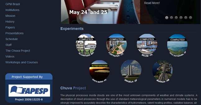


6 Field Campaign and SOS System CHUVA Portal:


7 Fortaleza Campaign System running in Civil Defense


8 Risk areas (flood, landslide) FORTALEZA SYSTEM


9 Flooding simulation Risk areas FORTALEZA SYSTEM


10 Belem Campaign Running in Meteorological Department at the University Together with Weather Service and Amazonas Surveillance System


11 BELÉM SYSTEM


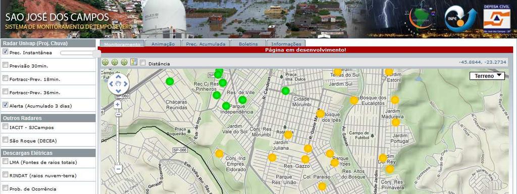
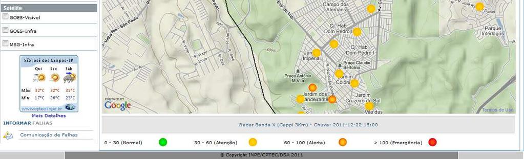
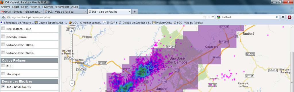
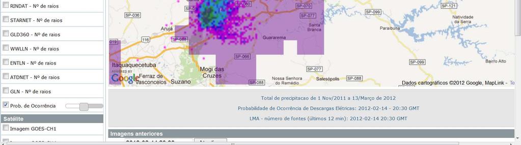
12 Severe Weather Monitoring System (SOS) SOS -Chuva Project CHUVA Project provides the SOS system, it is a pilot project for integrating environmental information enabling the optimization and assist planing of Defense Civil actions.

:")


13 GOES-R Geostationary Lightning Mapper (GLM): Pre-Launch Algorithm Validation-CHUVA Campaign Report Contribution to the CHUVA Campaign


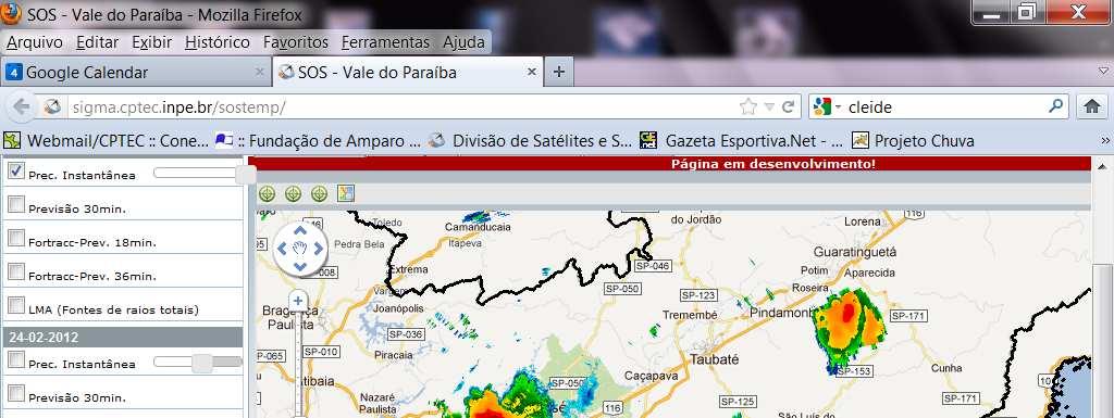
14 XPOL radar S-Band radars lightning satellite forecast São José dos Campos System sources of information

15 XPOL radar 100km radius (ring every 25km)
")
16 XPOL and S-Band (yellow) radar 250km radius (ring every 50km)
17 XPOL, S-Band and S-Band (orange) radars - 250km radius (ring every 50km)


18 Last Three Days Rainfall - Colors represent the warming status (as defined by Civil Defence) Rainfall data + cartography map = fast assimilation of current situation
19


20 Each point contain information about rainfall accumulated in 3 days


21 System can also provide a list of neighborhoods sorted by rainfall
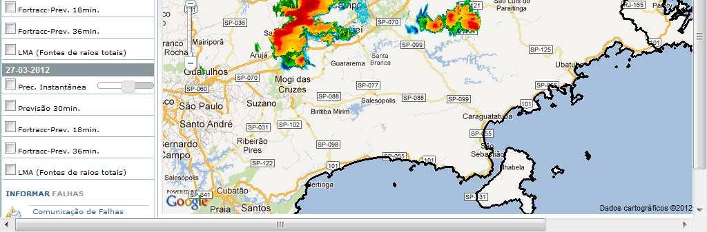
22


23


24
25

26 Figure 5. Histogramas das diferenças a) BTD n, b) BTD d, c) BTD , d) BTD , e e) BTD para os seis centróides Bright Band Stratiform Clouds. New Features being Introduced in SOS/ForTraCC Multichannel Satellite Winds Inner Cloud Top Structures High resolution winds computed from Brightness Temperature Difference Convective Cloud Top Features.(submitted to IJRS - Negri, Machado, Borde) Lightning Parameterization ForTraCC Parameterization as function of size, TB and Area expansion been including in Fortracc (Mattos and Machado ICAE 2011) The use of Brightness Temperature Difference To classify Cloud Reflectivity Profile (Lima and Machado, submitted to IJRS)
 + MAXREF ( dbz 5 52 ) + ALTMAXREF 5 3,6 ( km ) + ALTWALDVOG EL ( km ) 5 4,2 Rain Cells Cloud Top Rate and Area Expansion Dynamic Severity")
27 New Features being Introduced in SOS/ForTraCC Rain Cells Propagation Radar Severity Index ÍNDICE = VIL ( kg / m ²) DVIL 5 ( g / 1, 4 m ³) + MAXREF ( dbz 5 52 ) + ALTMAXREF 5 3,6 ( km ) + ALTWALDVOG EL ( km ) 5 4,2 Rain Cells Cloud Top Rate and Area Expansion Dynamic Severity Index
28 Conclusions CHUVA nowcasting test bed is proving the efficiency of free access of real time data and products to the population. SOS-ForTraCC is being tested and validaded showing very promise results. New products and different access levels (Science, Civil Defense and Population) to SOS Fortracc is a very important tool for science and disaster reduction effects.
29 Thank You Next CHUVA Campaign November- December 2012 Southern Brazil
CHUVA Project: and Perspectives for CHUVA Science Team
 CHUVA Project: 2010-2011 and Perspectives for 2012-2014 6 CHUVA Science Team Luiz.Machado@cptec.inpe.br CHUVA Project: Main Goals WORKING GROUP 1: CHARACTERISTICS OF THE PRECIPITATING SYSTEMS AS FUNCTION
IARA - GoAmazon 2014
 IARA - GoAmazon 2014 Activities related to Aerosol, Cloud, Precipitation, and Radiation Interactions and Dynamics of Convective Cloud Systems (ACRIDICON) and CHUVA Project Luiz.Machado@cptec.inpe.br General
The CHUVA Project: The prospects and preliminary results.
 The CHUVA Project: The prospects and preliminary results by CHUVA Science Team Luiz.Machado@cptec.inpe.br OUTLINE Pre-CHUVA: Some Results The CHUVA Project Update about the schedule The Field campaigns
TIME EVOLUTION OF A STORM FROM X-POL IN SÃO PAULO: 225 A ZH-ZDR AND TITAN METRICS COMPARISON
 TIME EVOLUTION OF A STORM FROM X-POL IN SÃO PAULO: 225 A ZH-ZDR AND TITAN METRICS COMPARISON * Roberto V Calheiros 1 ; Ana M Gomes 2 ; Maria A Lima 1 ; Carlos F de Angelis 3 ; Jojhy Sakuragi 4 (1) Voluntary
The Relationship Between Cloud And Rain Cells And The Role Of The Environment In Convective Processes During CHUVA-GoAmazon2014/5
 The Relationship Between Cloud And Rain Cells And The Role Of The Environment In Convective Processes During CHUVA-GoAmazon2014/5 Cristiano W. Eichholz 1, Courtney Schumacher 2, Luiz A. T. Machado 1 1.
PRELIMINARY STUDIES OF THE GNSS APPLICATION TO PRECIPITATION NOWCASTING Luiz Fernando Sapucci. Luiz Augusto Toledo Machado. Izabelly Carvalho.
 PRELIMINARY STUDIES OF THE GNSS APPLICATION TO PRECIPITATION NOWCASTING Luiz Fernando Sapucci. Luiz Augusto Toledo Machado. Izabelly Carvalho. Lucas Amarantes Avanço. Integrated water vapor from Global
Micro Squall Line in Belem region. Tarcísio Miranda do Amaral Neto (1) Júlia Clarinda Paiva Cohen (1) Luiz Augusto Toledo Machado (2)
 Júlia Clarinda Paiva Cohen (1) Luiz Augusto Toledo Machado (2)") 1 Micro Squall Line in Belem region Tarcísio Miranda do Amaral Neto (1) Júlia Clarinda Paiva Cohen (1) Luiz Augusto Toledo Machado (2) (1) Universidade Federal do Para, Belém, Brasil. (2) Centro de Previsão
1 Micro Squall Line in Belem region Tarcísio Miranda do Amaral Neto (1) Júlia Clarinda Paiva Cohen (1) Luiz Augusto Toledo Machado (2) (1) Universidade Federal do Para, Belém, Brasil. (2) Centro de Previsão
Investigating ice water path during convective cloud life cycles to improve passive microwave rainfall retrievals
 Investigating ice water path during convective cloud life cycles to improve passive microwave rainfall retrievals Ramon Campos Braga¹ and Daniel Alejandro Vila² 1-2 Divisão de Satélites e Sistemas Ambientais
Object-based approaches for exploring high-resolution simulations
 GEWEX Convection-Permitting Climate Modeling Meeting, Boulder, Colorado, 6-8 Sept 2016 Object-based approaches for exploring high-resolution simulations Jean-Pierre CHABOUREAU Laboratoire d Aérologie,
Mesoscale and High Impact Weather in the South American Monsoon Leila M. V. Carvalho 1 and Maria A. F. Silva Dias 2 1
 Mesoscale and High Impact Weather in the South American Monsoon Leila M. V. Carvalho 1 and Maria A. F. Silva Dias 2 1 University of California, Santa Barbara 2 University of Sao Paulo, Brazil Objectives
2.19 CONVECTIVE SYSTEM AREA EXPANSION, HIGH-LEVEL WIND DIVERGENCE AND VERTICAL VELOCITY: A TOOL FOR NOWCASTING
 2.19 CONVECTIVE SYSTEM AREA EXPANSION, HIGH-LEVEL WIND DIVERGENCE AND VERTICAL VELOCITY: A TOOL FOR NOWCASTING Luiz A. T. Machado 1, C. Morales 2, Henri Laurent 3, Daniel Vila 4, Suzana R. Macedo 1, Carlos
GoAMAZON CHUVA: GPM Ground Validation Activities. Daniel Vila - CPTEC/INPE and collaborators
 GoAMAZON CHUVA: GPM Ground Validation Activities Daniel Vila - CPTEC/INPE and collaborators 7th International Precipitation Working Group Workshop Tsukuba, 17-21 November, 2014 CHUVA PROJECT THE GOAMAZON
Group 2: Checking/Verification & Time Series
 Group 2: Checking/Verification & Time Series S.S.B. Brito 1, A. Calheiros 2, A. C. Corsi 3, L.R.L. Rodrigues 2, L.A. Pampuch 4, N. Rubido 5, T. L. Symons 6, and L. Xavier 7 1 CEMADEN, Brazil 2 INPE, Brazil
8A.5 MXPOL MEASUREMENTS OF WEATHER SYSTEMS
 8A.5 MXPOL MEASUREMENTS OF WEATHER SYSTEMS Augusto J. Pereira F o. 1*, Oswaldo Massambani 1, Ricardo Hallak 1, Cesar A. A. Beneti 2, and Rosangela B. B. Gin 3 1 USP, São Paulo; 2 SIMEPAR, Paraná; 3 UFEI,
We suspect the answer is a little bit of both these explanations. There is likely substantial under-reporting of severe weather in regions with either
 RELAMPAGO (Remote sensing of Electrification, Lightning, And Meso-scale/micro-scale Processes with Adaptive Ground Observations) - Relevance to NASA GPM GV Relampago means lightning in both Spanish and
DISTRIBUTION FUNCTIONS OF RAINFALL ESTIMATES FROM POLARIMETIC MEASUREMENTS AT X-BAND IN TROPICAL BRAZIL
 DISTRIBUTION FUNCTIONS OF RAINFALL ESTIMATES FROM POLARIMETIC MEASUREMENTS AT X-BAND IN TROPICAL BRAZIL Roberto Vicente Calheiros* 1, Maria Andrea Lima* 1, Ana Maria Gomes 1, Paulo Sergio Borges 1 Carlos
NOWCASTING PRODUCTS BASED ON MTSAT-1R RAPID SCAN OBSERVATION. In response to CGMS Action 38.33
 CGMS-39, JMA-WP-08 Prepared by JMA Agenda Item: G.II/8 Discussed in WG II NOWCASTING PRODUCTS BASED ON MTSAT-1R RAPID SCAN OBSERVATION In response to CGMS Action 38.33 This document reports on JMA s MTSAT-1R
Understanding and forecasting extreme weather events in Andes lee side: The Relampago opportunity
 Understanding and forecasting extreme weather events in Andes lee side: The Relampago opportunity Ariane Frassoni Center for Weather Forecasting and Climate Studies National Institute for Space Research
COMBINATION OF SATELLITE PRECIPITATION ESTIMATES AND RAIN GAUGE FOR HIGH SPATIAL AND TEMPORAL RESOLUTIONS INTRODUCTION
 COMBINATION OF SATELLITE PRECIPITATION ESTIMATES AND RAIN GAUGE FOR HIGH SPATIAL AND TEMPORAL RESOLUTIONS Ferreira, Rute Costa¹ ; Herdies, D. L.¹; Vila, D.A.¹; Beneti, C.A. A.² ¹ Center for Weather Forecasts
PAGASA s Expectations of New-generation Satellites for Hazard Monitoring
 Country Report Philippines PAGASA s Expectations of New-generation Satellites for Hazard Monitoring VICENTE P. PALCON, JR. (Assistant Weather Services Chief) Weather Division- PAGASA DOST Email: vppalconjr@pagasa.dost.gov.ph
SWOT-GPM Exploring the complementarities in altimetry and rainfall measurement from satellite, in tropical basins.
 SWOT-GPM Exploring the complementarities in altimetry and rainfall measurement from satellite, in tropical basins. PIs : Marielle Gosset (IRD, GET, France) and Daniel Vila (INPE, CPTEC, Brazil) cois :
Operational quantitative precipitation estimation using radar, gauge g and
 Operational quantitative precipitation estimation using radar, gauge g and satellite for hydrometeorological applications in Southern Brazil Leonardo Calvetti¹, Cesar Beneti¹, Diogo Stringari¹, i¹ Alex
1. FY10 GOES-R3 Project Proposal Title Page
 1. FY10 GOES-R3 Project Proposal Title Page Title: Transitioning GOES-Based Nowcasting Capability into the GOES-R Era Project Type: Product development Proposal Status: Renewal Duration: 3 years FY08 -
Strategic Radar Enhancement Project (SREP) Forecast Demonstration Project (FDP) The future is here and now
 Forecast Demonstration Project (FDP) The future is here and now") Strategic Radar Enhancement Project (SREP) Forecast Demonstration Project (FDP) The future is here and now Michael Berechree National Manager Aviation Weather Services Australian Bureau of Meteorology
Strategic Radar Enhancement Project (SREP) Forecast Demonstration Project (FDP) The future is here and now Michael Berechree National Manager Aviation Weather Services Australian Bureau of Meteorology
Preliminary results. Leonardo Calvetti, Rafael Toshio, Flávio Deppe and Cesar Beneti. Technological Institute SIMEPAR, Curitiba, Paraná, Brazil
 HIGH RESOLUTION WRF SIMULATIONS FOR WIND GUST EVENTS Preliminary results Leonardo Calvetti, Rafael Toshio, Flávio Deppe and Cesar Beneti Technological Institute SIMEPAR, Curitiba, Paraná, Brazil 3 rd WMO/WWRP
WMO Priorities and Perspectives on IPWG
 WMO Priorities and Perspectives on IPWG Stephan Bojinski WMO Space Programme IPWG-6, São José dos Campos, Brazil, 15-19 October 2012 1. Introduction to WMO Extended Abstract The World Meteorological Organization
MESO-NH cloud forecast verification with satellite observation
 MESO-NH cloud forecast verification with satellite observation Jean-Pierre CHABOUREAU Laboratoire d Aérologie, University of Toulouse and CNRS, France http://mesonh.aero.obs-mip.fr/chaboureau/ DTC Verification
STATUS OF THE OPERATIONAL SATELLITE WINDS PRODUCTION AT CPTEC/INPE AND IT USAGE IN REGIONAL DATA ASSIMILATION OVER SOUTH AMERICA
 Proceedings for the 13 th International Winds Workshop 27 June - 1 July 2016, Monterey, California, USA STATUS OF THE OPERATIONAL SATELLITE WINDS PRODUCTION AT CPTEC/INPE AND IT USAGE IN REGIONAL DATA
T-re Plots Generated from MSG Data in Severe Storms Forecasting Testing in Central Europe
 WDS'11 Proceedings of Contributed Papers, Part III, 88 92, 2011. ISBN 978-80-7378-186-6 MATFYZPRESS T-re Plots Generated from MSG Data in Severe Storms Forecasting Testing in Central Europe M. Pokorný
Thunderstorms characteristics during ACRIDICON-CHUVA and GoAmazon field campaigns
 AGU Fall Meeting, 14-18 December 2015 Thunderstorms characteristics during ACRIDICON-CHUVA and GoAmazon field campaigns Rachel Albrecht, Ramon Braga, Carlos Morales, Hartmut Höller, Luiz Machado, Daniel
Warning procedures for extreme events in the Emilia-Romagna Region
 Warning procedures for extreme events in the Emilia-Romagna Region Anna Fornasiero, Miria Celano, Roberta Amorati, Virginia Poli and Pier Paolo Alberoni Arpa Emilia-Romagna Hydro-Meteo-Climate Service,
Improving real time observation and nowcasting RDT. E de Coning, M Gijben, B Maseko and L van Hemert Nowcasting and Very Short Range Forecasting
 Improving real time observation and nowcasting RDT E de Coning, M Gijben, B Maseko and L van Hemert Nowcasting and Very Short Range Forecasting Introduction Satellite Application Facilities (SAFs) are
The Nowcasting Demonstration Project for London 2012
 The Nowcasting Demonstration Project for London 2012 Susan Ballard, Zhihong Li, David Simonin, Jean-Francois Caron, Brian Golding, Met Office, UK Introduction The success of convective-scale NWP is largely
DISTRIBUTION AND DIURNAL VARIATION OF WARM-SEASON SHORT-DURATION HEAVY RAINFALL IN RELATION TO THE MCSS IN CHINA
 3 DISTRIBUTION AND DIURNAL VARIATION OF WARM-SEASON SHORT-DURATION HEAVY RAINFALL IN RELATION TO THE MCSS IN CHINA Jiong Chen 1, Yongguang Zheng 1*, Xiaoling Zhang 1, Peijun Zhu 2 1 National Meteorological
Severe storms over the Mediterranean Sea: A satellite and model analysis
 National Research Council of Italy Severe storms over the Mediterranean Sea: A satellite and model analysis V. Levizzani, S. Laviola, A. Malvaldi, M. M. Miglietta, and E. Cattani 6 th International Precipitation
Weather. Chapter Test A. Multiple Choice. Write the letter of the correct answer on the line at the left.
 Weather Chapter Test A Multiple Choice Write the letter of the correct answer on the line at the left. 1. The most dangerous aspect of a snowstorm is often the a. high winds. b. depth of snow. c. brightness.
Lecture 4b: Meteorological Satellites and Instruments. Acknowledgement: Dr. S. Kidder at Colorado State Univ.
 Lecture 4b: Meteorological Satellites and Instruments Acknowledgement: Dr. S. Kidder at Colorado State Univ. US Geostationary satellites - GOES (Geostationary Operational Environmental Satellites) US
Nowcasting of Severe Weather from Satellite Images (for Southern
 Nowcasting of Severe Weather from Satellite Images (for Southern Europe) Petra Mikuš Jurković Forecasting/ nowcasting of convective storms NWP models cannot well predict the exact location and intesity
Convective Structures in Clear-Air Echoes seen by a Weather Radar
 Convective Structures in Clear-Air Echoes seen by a Weather Radar Martin Hagen Deutsches Zentrum für Luft- und Raumfahrt Oberpfaffenhofen, Germany Weather Radar Weather radar are normally used to locate
Rain Cells Propagations: An evaluation of different propagation models. National Institute for Space Research, São Paulo, Brazil
 1 Rain Cells Propagations: An evaluation of different propagation models 2 3 Cristiano Wickboldt Eichholz 1 and Luiz Augusto Toledo Machado 2 National Institute for Space Research, São Paulo, Brazil 4
Judit Kerényi. OMSZ - Hungarian Meteorological Service, Budapest, Hungary. H-1525 Budapest, P.O.Box 38, Hungary.
 SATELLITE-DERIVED PRECIPITATION ESTIMATIONS DEVELOPED BY THE HYDROLOGY SAF PROJECT CASE STUDIES FOR THE INVESTIGATION OF THEIR ACCURACY AND FEATURES IN HUNGARY Judit Kerényi OMSZ - Hungarian Meteorological
H-SAF future developments on Convective Precipitation Retrieval
 H-SAF future developments on Convective Precipitation Retrieval Francesco Zauli 1, Daniele Biron 1, Davide Melfi 1, Antonio Vocino 1, Massimiliano Sist 2, Michele De Rosa 2, Matteo Picchiani 2, De Leonibus
Global Precipitation Measurement (GPM) for Science and Society
 for Science and Society") Global Precipitation Measurement (GPM) for Science and Society Gail Skofronick-Jackson GPM Project Scientist NASA Goddard Space Flight Center Radar Observation of Rain from Space Tokyo, Japan 29 November
Global Precipitation Measurement (GPM) for Science and Society Gail Skofronick-Jackson GPM Project Scientist NASA Goddard Space Flight Center Radar Observation of Rain from Space Tokyo, Japan 29 November
REQUIREMENTS FOR WEATHER RADAR DATA. Review of the current and likely future hydrological requirements for Weather Radar data
 WORLD METEOROLOGICAL ORGANIZATION COMMISSION FOR BASIC SYSTEMS OPEN PROGRAMME AREA GROUP ON INTEGRATED OBSERVING SYSTEMS WORKSHOP ON RADAR DATA EXCHANGE EXETER, UK, 24-26 APRIL 2013 CBS/OPAG-IOS/WxR_EXCHANGE/2.3
Utilising Radar and Satellite Based Nowcasting Tools for Aviation Purposes in South Africa. Erik Becker
 Utilising Radar and Satellite Based Nowcasting Tools for Aviation Purposes in South Africa Erik Becker Morné Gijben, Mary-Jane Bopape, Stephanie Landman South African Weather Service: Nowcasting and Very
Remote Sensing of Precipitation
 Lecture Notes Prepared by Prof. J. Francis Spring 2003 Remote Sensing of Precipitation Primary reference: Chapter 9 of KVH I. Motivation -- why do we need to measure precipitation with remote sensing instruments?
Instituto de Pesquisas Meteorológicas - IPMet Universidade Estadual Paulista - Unesp
 IPMET WEB GIS APPLICATION FOR SEVERE WEATHER ALERT AND DECISION SUPPORT Jaqueline Murakami Kokitsu Instituto de Pesquisas Meteorológicas - IPMet Universidade Estadual Paulista - Unesp IPMet/Unesp Meteorological
APPENDIX 2 OVERVIEW OF THE GLOBAL PRECIPITATION MEASUREMENT (GPM) AND THE TROPICAL RAINFALL MEASURING MISSION (TRMM) 2-1
 AND THE TROPICAL RAINFALL MEASURING MISSION (TRMM) 2-1") APPENDIX 2 OVERVIEW OF THE GLOBAL PRECIPITATION MEASUREMENT (GPM) AND THE TROPICAL RAINFALL MEASURING MISSION (TRMM) 2-1 1. Introduction Precipitation is one of most important environmental parameters.
APPENDIX 2 OVERVIEW OF THE GLOBAL PRECIPITATION MEASUREMENT (GPM) AND THE TROPICAL RAINFALL MEASURING MISSION (TRMM) 2-1 1. Introduction Precipitation is one of most important environmental parameters.
Remote Sensing in Meteorology: Satellites and Radar. AT 351 Lab 10 April 2, Remote Sensing
 Remote Sensing in Meteorology: Satellites and Radar AT 351 Lab 10 April 2, 2008 Remote Sensing Remote sensing is gathering information about something without being in physical contact with it typically
Module 11: Meteorology Topic 5 Content: Weather Maps Notes
 Introduction A variety of weather maps are produced by the National Weather Service and National Oceanographic Atmospheric Administration. These maps are used to help meteorologists accurately predict
Judit Kerényi. OMSZ-Hungarian Meteorological Service P.O.Box 38, H-1525, Budapest Hungary Abstract
 Comparison of the precipitation products of Hydrology SAF with the Convective Rainfall Rate of Nowcasting-SAF and the Multisensor Precipitation Estimate of EUMETSAT Judit Kerényi OMSZ-Hungarian Meteorological
Outline. Research Achievements
 Taiwan Typhoon and Flood Research Institute, National Applied Research Laboratories 11F., No.97, Sec. 1, Roosevelt Rd., Zhongzheng Dist., Taipei City 10093, Taiwan (R.O.C.) http://www.ttfri.narl.org.tw/eng/index.html
Civil protection. (public, government and local authorities institutions)
") 23 Civil protection (public, government and local authorities institutions) Overview Statistics from the Centre for Research on the Epidemiology of Disasters (CRED) at the University of Leuven, Belgium,
23 Civil protection (public, government and local authorities institutions) Overview Statistics from the Centre for Research on the Epidemiology of Disasters (CRED) at the University of Leuven, Belgium,
Incorporation of 3D Shortwave Radiative Effects within the Weather Research and Forecasting Model
 Incorporation of 3D Shortwave Radiative Effects within the Weather Research and Forecasting Model W. O Hirok and P. Ricchiazzi Institute for Computational Earth System Science University of California
Weather report 28 November 2017 Campinas/SP
 Weather report 28 November 2017 Campinas/SP Summary: 1) Synoptic analysis and pre-convective environment 2) Verification 1) Synoptic analysis and pre-convective environment: At 1200 UTC 28 November 2017
MSG FOR NOWCASTING - EXPERIENCES OVER SOUTHERN AFRICA
 MSG FOR NOWCASTING - EXPERIENCES OVER SOUTHERN AFRICA Estelle de Coning and Marianne König South African Weather Service, Private Bag X097, Pretoria 0001, South Africa EUMETSAT, Am Kavalleriesand 31, D-64295
Evaluation of BRAMS Turbulence Schemes during a Squall Line Occurrence in São Paulo, Brazil
 American Journal of Environmental Engineering 2013, 3(1): 1-7 DOI: 10.5923/j.ajee.20130301.01 Evaluation of BRAMS Turbulence Schemes during a Squall Line Occurrence in São Paulo, Brazil Andréia Bender
Research on Lightning Nowcasting and Warning System and Its Application
 Research on Lightning Nowcasting and Warning System and Its Application Wen Yao Chinese Academy of Meteorological Sciences Beijing, China yaowen@camscma.cn 2016.07 1 CONTENTS 1 2 3 4 Lightning Hazards
Trends Forecasting. Overview: Objectives: GLEs Addressed: Materials: Activity Procedure:
 Trends Forecasting Overview: How do meteorologists forecast weather? Students learn one of 5 main methods for forecasting weather, use it to create a forecast, and analyze results. Objectives: The student
Assimilation of precipitation-related observations into global NWP models
 Assimilation of precipitation-related observations into global NWP models Alan Geer, Katrin Lonitz, Philippe Lopez, Fabrizio Baordo, Niels Bormann, Peter Lean, Stephen English Slide 1 H-SAF workshop 4
MICROPHYSICAL ANALYSIS OF SNOWFALL EPISODES THROUGH THE DISPERSION PROFILES
 MICROPHYSICAL ANALYSIS OF SNOWFALL EPISODES THROUGH THE DISPERSION PROFILES Laura López (1), José Prieto (2), J.L. Sánchez (1), E. García-Ortega (1), Rafael Posada (1) (1) Group for Atmospheric Physics,
SUPER-RAPID SCAN SATELLITE IMAGERY ANALYSIS OF TWO HAILSTORMS SAMPLED BY HAILSTONE
 SUPER-RAPID SCAN SATELLITE IMAGERY ANALYSIS OF TWO HAILSTORMS SAMPLED BY HAILSTONE Jennifer M. Laflin* and Scott F. Blair NOAA/NWS Kansas City/Pleasant Hill, Missouri Chad Gravelle NOAA/NWS Operations
EUMETSAT Hydrological SAF H05 product development at CNMCA
 EUMETSAT Hydrological SAF H05 product development at CNMCA Luigi De Leonibus, Francesco Zauli, Antonio Vocino, Daniele Biron, Davide Melfi, Marco Petracca Centro Nazionale di Meteorologia e Climatologia
Comparison of TRMM LIS and PR with ground based lightning and radar observations for the TROCCINOX/ TroCCiBras/HIBISCUS field campaign
 Comparison of TRMM LIS and PR with ground based lightning and radar observations for the TROCCINOX/ TroCCiBras/HIBISCUS field campaign Thorsten Fehr, IPA/DLR, Germany Gerhard Held, IPMet/UNESP, Brazil
Use of lightning data to improve observations for aeronautical activities
 Use of lightning data to improve observations for aeronautical activities Françoise Honoré Jean-Marc Yvagnes Patrick Thomas Météo_France Toulouse France I Introduction Aeronautical activities are very
GPS Meteorology at Japan Meteorological Agency
 GPS Meteorology at Japan Meteorological Agency Masahito Ishihara Japan Meteorological Agency CIMO Expert Team on Remote Sensing Upper-Air Technology and Techniques 14-17 March, 2005 Geneva, Switzerland
Variational data assimilation of lightning with WRFDA system using nonlinear observation operators
 Variational data assimilation of lightning with WRFDA system using nonlinear observation operators Virginia Tech, Blacksburg, Virginia Florida State University, Tallahassee, Florida rstefane@vt.edu, inavon@fsu.edu
DECISION TREE CLASSIFICATION MODEL FOR DETECTING AND TRACKING PRECIPITATING OBJECTS FROM SERIES OF METEOROLOGICAL IMAGES
 DECISION TREE CLASSIFICATION MODEL FOR DETECTING AND TRACKING PRECIPITATING OBJECTS FROM SERIES OF METEOROLOGICAL IMAGES S. Ramirez a, I. Lizarazo b a Facultad de ingenería, Universidad Distrital Francisco
AS Atmospheric Sciences Orals and PICOs Monday, 08 April
 AS Atmospheric Sciences Orals and PICOs Monday, 08 April MO1, 08:30 10:00 MO2, 10:30 12:00 MOL, 12:15 13:15 MO3, 13:30 15:00 AS1.1, Numerical weather prediction, data assimilation and ensemble forecasting,
Chengsi Liu 1, Ming Xue 1, 2, Youngsun Jung 1, Lianglv Chen 3, Rong Kong 1 and Jingyao Luo 3 ISDA 2019
 Development of Optimized Radar Data Assimilation Capability within the Fully Coupled EnKF EnVar Hybrid System for Convective Permitting Ensemble Forecasting and Testing via NOAA Hazardous Weather Testbed
Guided Reading Chapter 18: Weather Patterns
 Name Number Date Guided Reading Chapter 18: Weather Patterns 18-1: Air Masses and Fronts 1. What is an air mass? 2. Scientists classify air masses according to and 3. Is the following sentence true or
Deterministic and Ensemble Storm scale Lightning Data Assimilation
 LI Mission Advisory Group & GOES-R Science Team Workshop 27-29 May 2015 Deterministic and Ensemble Storm scale Lightning Data Assimilation Don MacGorman, Ted Mansell (NOAA/National Severe Storms Lab) Alex
Lightning Data Assimilation using an Ensemble Kalman Filter
 Lightning Data Assimilation using an Ensemble Kalman Filter G.J. Hakim, P. Regulski, Clifford Mass and R. Torn University of Washington, Department of Atmospheric Sciences Seattle, United States 1. INTRODUCTION
QPE and QPF in the Bureau of Meteorology
 QPE and QPF in the Bureau of Meteorology Current and future real-time rainfall products Carlos Velasco (BoM) Alan Seed (BoM) and Luigi Renzullo (CSIRO) OzEWEX 2016, 14-15 December 2016, Canberra Why do
CRM and LES approaches for simulating tropical deep convection: successes and challenges
 ECMWF workshop on shedding light on the greyzone, Reading, UK, 13-16 Nov 2017 CRM and LES approaches for simulating tropical deep convection: successes and challenges Jean-Pierre CHABOUREAU Laboratoire
Communicating uncertainty from short-term to seasonal forecasting
 Communicating uncertainty from short-term to seasonal forecasting MAYBE NO YES Jay Trobec KELO-TV Sioux Falls, South Dakota USA TV weather in the US Most TV weather presenters have university degrees and
Vertically Integrated Ice A New Lightning Nowcasting Tool. Matt Mosier. NOAA/NWS Fort Worth, TX
 P686 Vertically Integrated Ice A New Lightning Nowcasting Tool Matt Mosier NOAA/NWS Fort Worth, TX 1. BACKGROUND AND METHODOLOGY Lightning is a frequent and dangerous phenomenon, especially in the summer
RELAMPAGO. Remote sensing of Electrification, Lightning, And Meso-scale/microscale Processes with Adaptive Ground Observations
 RELAMPAGO Remote sensing of Electrification, Lightning, And Meso-scale/microscale Processes with Adaptive Ground Observations (relampago translates to lightning in Spanish and Portuguese) RELAMPAGO (a
Fundamentals of Radar Display. Atmospheric Instrumentation
 Fundamentals of Radar Display Outline Fundamentals of Radar Display Scanning Strategies Basic Geometric Varieties WSR-88D Volume Coverage Patterns Classic Radar Displays and Signatures Precipitation Non-weather
Aviation Hazards: Thunderstorms and Deep Convection
 Aviation Hazards: Thunderstorms and Deep Convection TREND Diagnosis of thunderstorm hazards using imagery Contents Satellite imagery Visible, infrared, water vapour Basic cloud identification Identifying
AN OBSERVING SYSTEM EXPERIMENT OF MTSAT RAPID SCAN AMV USING JMA MESO-SCALE OPERATIONAL NWP SYSTEM
 AN OBSERVING SYSTEM EXPERIMENT OF MTSAT RAPID SCAN AMV USING JMA MESO-SCALE OPERATIONAL NWP SYSTEM Koji Yamashita Japan Meteorological Agency / Numerical Prediction Division 1-3-4, Otemachi, Chiyoda-ku,
Commercialisation. Lessons learned from Dutch weather market
 Commercialisation Lessons learned from Dutch weather market Where information comes together weather traffic public transport Weather, traffic and public transport. Daily actual information that influences
São Paulo Lightning Mapping Array (SP-LMA): Network Assessment and Analyses for Intercomparison Studies and GOES-R Proxy Activities
: Network Assessment and Analyses for Intercomparison Studies and GOES-R Proxy Activities") São Paulo Lightning Mapping Array (SP-LMA): Network Assessment and Analyses for Intercomparison Studies and GOES-R Proxy Activities R. J. Blakeslee 1, J. C. Bailey 2, L.D. Carey 3, S. J. Goodman 4, S.D.
São Paulo Lightning Mapping Array (SP-LMA): Network Assessment and Analyses for Intercomparison Studies and GOES-R Proxy Activities R. J. Blakeslee 1, J. C. Bailey 2, L.D. Carey 3, S. J. Goodman 4, S.D.
Introduction to the NWC SAF
 Introduction to the NWC SAF NWC SAF Event Week EUMeTrain course 18-22 November, online P. Fernández 1 Where are you listening from? Contents SAF Network scope NWC SAF Overview Products Next versions 2014
Meteorology 311. RADAR Fall 2016
 Meteorology 311 RADAR Fall 2016 What is it? RADAR RAdio Detection And Ranging Transmits electromagnetic pulses toward target. Tranmission rate is around 100 s pulses per second (318-1304 Hz). Short silent
BY REAL-TIME ClassZR. Jeong-Hee Kim 1, Dong-In Lee* 2, Min Jang 2, Kil-Jong Seo 2, Geun-Ok Lee 2 and Kyung-Eak Kim 3 1.
 P2.6 IMPROVEMENT OF ACCURACY OF RADAR RAINFALL RATE BY REAL-TIME ClassZR Jeong-Hee Kim 1, Dong-In Lee* 2, Min Jang 2, Kil-Jong Seo 2, Geun-Ok Lee 2 and Kyung-Eak Kim 3 1 Korea Meteorological Administration,
Hail nowcast exploiting radar and satellite observations
 Federal Department of Home Affairs FDHA Federal Office of Meteorology and Climatology MeteoSwiss Hail nowcast exploiting radar and satellite observations Ulrich Hamann, Elena Leonarduzzi, Kristopher Bedka,
Nowcasting thunderstorms for aeronautical end-users
 Nowcasting thunderstorms for aeronautical end-users Jean-Marc Moisselin Météo-France, Nowcasting Department co-authors: Céline Jauffret (Météo-France) Overview Introduction SAT RADAR NWP image crédit:
Performance of a Probabilistic Cloud-to-Ground Lightning Prediction Algorithm
 Performance of a Probabilistic Cloud-to-Ground Lightning Prediction Algorithm John Cintineo 1,2,3 * Valliappa Lakshmanan 1,2, Travis Smith 1,2 Abstract A probabilistic cloud- to- ground lightning algorithm
FLORA: FLood estimation and forecast in complex Orographic areas for Risk mitigation in the Alpine space
 Natural Risk Management in a changing climate: Experiences in Adaptation Strategies from some European Projekts Milano - December 14 th, 2011 FLORA: FLood estimation and forecast in complex Orographic
Convective-scale NWP for Singapore
 Convective-scale NWP for Singapore Hans Huang and the weather modelling and prediction section MSS, Singapore Dale Barker and the SINGV team Met Office, Exeter, UK ECMWF Symposium on Dynamical Meteorology
The Rainfall System Classification over the Korean Peninsula Using TRMM TMI and Ground Measurement Data
 6 th International Precipitation Working Group Workshop-São José dos Campos- October 15~19, 2012 The Rainfall System Classification over the Korean Peninsula Using TRMM TMI and Ground Measurement Data
The Hydrologic Cycle: How Do River Forecast Centers Measure the Parts?
 The Hydrologic Cycle: How Do River Forecast Centers Measure the Parts? Greg Story Meteorologist National Weather Service Fort Worth, TX Overview n Introduction What is the mission of an RFC? n The Hydrologic
HY-2A Satellite User s Guide
 National Satellite Ocean Application Service 2013-5-16 Document Change Record Revision Date Changed Pages/Paragraphs Edit Description i Contents 1 Introduction to HY-2 Satellite... 1 2 HY-2 satellite data
A new mesoscale NWP system for Australia
 A new mesoscale NWP system for Australia www.cawcr.gov.au Peter Steinle on behalf of : Earth System Modelling (ESM) and Weather&Environmental Prediction (WEP) Research Programs, CAWCR Data Assimilation
WMO SCOPE-Nowcasting using new-generation satellite data: Progress and Perspectives
 WMO SCOPE-Nowcasting using new-generation satellite data: Progress and Perspectives Stephan Bojinski WMO Space Programme 8 th Asia-Oceania Meteorological Satellite Users Conference Vladivostok, Russia,
DATA FUSION NOWCASTING AND NWP
 DATA FUSION NOWCASTING AND NWP Brovelli Pascal 1, Ludovic Auger 2, Olivier Dupont 1, Jean-Marc Moisselin 1, Isabelle Bernard-Bouissières 1, Philippe Cau 1, Adrien Anquez 1 1 Météo-France Forecasting Department
Performance of TANC (Taiwan Auto- Nowcaster) for 2014 Warm-Season Afternoon Thunderstorm
 for 2014 Warm-Season Afternoon Thunderstorm") Performance of TANC (Taiwan Auto- Nowcaster) for 2014 Warm-Season Afternoon Thunderstorm Wei-Peng Huang, Hui-Ling Chang, Yu-Shuang Tang, Chia-Jung Wu, Chia-Rong Chen Meteorological Satellite Center, Central
Performance of TANC (Taiwan Auto- Nowcaster) for 2014 Warm-Season Afternoon Thunderstorm Wei-Peng Huang, Hui-Ling Chang, Yu-Shuang Tang, Chia-Jung Wu, Chia-Rong Chen Meteorological Satellite Center, Central
Emerging Needs, Challenges and Response Strategy
 Emerging Needs, Challenges and Response Strategy Development of Integrated Observing Systems in China JIAO Meiyan Deputy Administrator China Meteorological Administration September 2011 Geneva Outline
Asian THORPEX Implementation Plan
 Asian THORPEX Implementation Plan 1. Introduction This document is to describe the Implementation Plan of the Asian THORPEX, that the Asian THORPEX Regional Committee (ARC) approves. THORPEX was established