Communicating with Maps and Graphics NWS Products and Services
|
|
|
- Silvester Glenn
- 6 years ago
- Views:
Transcription


1 Communicating with Maps and Graphics NWS Products and Services 2012 NC Hurricane Workshop May 23, 2012 Rich Bandy, Meteorologist-in-Charge National Weather Service WFO Newport/Morehead City, NC

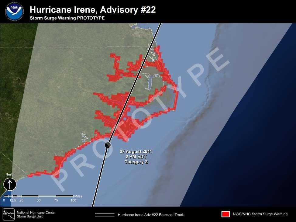
2 Hurricane Irene Track Forecast

3 Hurricane Irene Track Forecast


4 Interpreting the Cone Represents the probable track of the center of the tropical cyclone. Formed by connecting circles centered on each forecast point (at 12, 24, 36 h, etc.) Size of the circles determined so that the actual storm position will be within the circle 2 out of 3 times, based on NHC statistics from the previous 5 hurricane seasons It is important to remember that the center of the storm will remain entirely within the cone only about 60 70% of the time
5 Interpreting the Cone The cone only depicts probable track of the center of the tropical cyclone. It says nothing about wind impacts It says nothing about storm surge impacts It says nothing about rainfall and/or flooding impacts It says nothing about tornado impacts It says nothing about rip currents and waves

6 Tropical Impact Graphics These graphical impact graphics become available when an area is placed under a tropical storm or hurricane watch or warning (typically 36 to 48 hours in advance of landfall.)


7 Tornado Impact Graphics

8 Tornado Impacts Columbia, NC EF Scale Rating - EF2 Estimated Max Winds 130 mph Maximum Width 50 yards Path Length 0.5 miles Cresswell, NC EF Scale Rating EF1 Estimated Max Winds 110 mph Maximum Width 50 yards Path Length 0.5 miles Belhaven, NC EF Scale Rating EF1 Estimated Max Winds 105 mph Maximum Width 75 yards Path Length 4.40 miles


9 Inland Flooding Impact Graphics

10 Heavy Rainfall Impacts

11 Wind Impact Graphics 24 hours prior to landfall projection of 115 MPH hurricane

12 Wind Observations
13 Probabalistic Winds


14 Hurricane Irene Wind Extent Graphic
 On our website")


15 National Digital Forecast Database (NDFD) On our website under Gridded Images 7-Day public, marine & fire weather forecasts Dozens of elements shown in graphic format: temperature, weather, sky cover, relative humidity, wind speed/direction, seas and many more!

16 Hourly Weather Graph

17 Potential Wind Graphic


18 Coastal Flooding Impact Graphics 18 hours prior to landfall
 Reference")
19 Height Above Height Above Ground Level (Inundation) Reference Level


20 Height Above Height Above Ground Level (Inundation) Reference Level

21 Surge Referenced Above Ground 4
")
22 Storm Surge Observations (Above Normal High Tide)

23 Storm Surge Observations (Above Ground Level)
")
24 Storm Surge Observations (Above Normal High Tide)

25 Storm Surge Observations (Above Ground Level)

26 Hickory Point On the Pamlico River, Beaufort County, at the height of Irene. Courtesy Williamson Family

27 Hickory Point On the Pamlico River, Beaufort County, at the height of Irene. Courtesy Williamson Family

28 Hickory Point Older homes wiped clean off the foundation and off the peninsula entirely.

29 Hickory Point Many homes pushed off their foundation.

30 Hickory Point Rip-rap from seawall carried inland/home damage. Courtesy Williamson Family
31 Irene Outer Banks Sound Side Surge Oregon Inlet USCG Cape Hatteras


32 Pea Island Cut Left: 2011 after Irene/Right: 1993 Note: Highway 12 was on the coast side of the maintenance buildings in 1993.

33 Pea Island: Images from USGS

34 Rodanthe S-Curves Dune breach/inlet cut at Mirlo Beach.
35 Storm Surge Guidance SLOSH Along Forecast Track Run

36 Storm Surge Guidance SLOSH Left of Forecast Track Run

37 Storm Surge Guidance SLOSH Right of Forecast Track Run

38 Storm Surge Guidance Maximum Envelope Of Water MEOW Aggregate of Tracks for a CAT 3 Moving NNE at 15 mph at High Tide

39 Storm Surge Guidance Maximum Of the MEOWS MOM Aggregate of Tracks for a CAT 3 of All Directions and Speed at High Tide
40 Probabilisitic Storm Surge Guidance Takes into account actual NHC Track Forecast and statistics of NHC error including: timing, location, intensity, and size of storm. Uses an ensemble of SLOSH runs to create probabilistic storm surge (p-surge) Different directions of motion Different landfall locations Different intensities Different storm sizes Different forward speeds


41 Probabilisitic Storm Surge Available when the NHC issues a hurricane watch or warning for the continental US. Can be utilized to assess potential surge based on uncertainties in forecast. Guidance Available approx. 1-2 hours after the advisory release time Used to assist in generating coastal flooding impact graphics and surge forecasts in NHC and local NWS office text products.

42
43
44 URGENT - IMMEDIATE BROADCAST REQUESTED HURRICANE IRENE LOCAL STATEMENT NATIONAL WEATHER SERVICE NEWPORT/MOREHEAD CITY NC 1158 PM EDT FRI AUG SITUATION OVERVIEW... WHEN MAKING DECISIONS...DO NOT FOCUS ON THE EXACT FORECAST TRACK....IRENE MOVING NORTH-NORTHEASTWARD TOWARD SOUTHEASTERN DUE TO SIZE NORTH AND.PRECAUTIONARY/PREPAREDNESS THE STRENGTH OF HURRICANE ACTIONS... IRENE...SIGNIFICANT CAROLINA...TROPICAL STORM CONDITIONS LASHING THE IMPACTS CAROLINA WILL COAST... OCCUR PRECAUTIONARY/PREPAREDNESS WELL AWAY FROM THE STORM ACTIONS... CENTER. SIGNIFICANT STORM SURGE...DAMAGING WINDS AND FRESH WATER FLOODING ARE EXPECTED.NEW INFORMATION... AS IRENE AFFECTS TORNADO WATCH HAS BEEN ISSUED FOR MUCH OF EASTERN NORTH CAROLINA. PREPARATIONS THE AREA. TROPICAL FOR THE STORM PROTECTION FORCE WINDS OF LIFE HAVE AND MOVED PROPERTY SHOULD BE INTO SOUTHERN NORTH COMPLETED CAROLINA...AND AT THIS TIME. WILL EVACUATE SPREAD NORTHWARD IF DIRECTED THROUGH TO DO SO BY LOCAL THE NIGHT. HURRICANE.AREAS AFFECTED... OFFICIALS...OR FORCE WINDS IF YOUR ARE HOME FORECAST IS VULNERABLE TO BEGIN ACROSS TO HIGH THE WINDS OR SOUTHERN PORTIONS THIS LOCAL STATEMENT PROVIDES IMPORTANT INFORMATION AND FLOODING. AROUND 5 AM AND NORTHERN PORTIONS OF THE RECOMMENDED ACTIONS FOR PEOPLE AND MARINE INTERESTS HURRICANE IN SELECT WARNING AREA AT 8 AM. THE OFFICIAL FORECAST CALLS FOR LOCATIONS AND COASTAL WATER LEGS OF EASTERN NORTH HURRICANE CAROLINA IRENE AND SMALL TO MAKE CRAFT LANDFALL SHOULD NEAR REMAIN CAPE IN LOOKOUT PORT AND AROUND WELL SECURED. 11 AM ADJACENT COASTAL WATERS. SATURDAY. FOR ADDITIONAL PRECAUTIONARY AND PREPAREDNESS INFORMATION....WATCHES/WARNINGS... A FLOOD WATCH IS PLEASE IN EFFECT REFER FOR TO ALL THE OF DETAILED EASTERN RECOMMENDATIONS NORTH CAROLINA. RELATIVE TO YOUR A HURRICANE WARNING CONTINUES FOR THE FOLLOWING RAINFALL LOCATIONS... WILL INCREASE LOCATION IN INTENSITY AS FURTHER AS HURRICANE DESCRIBED BY IRENE YOUR MOVES LOCAL NATIONAL WEATHER MARTIN...PITT...WASHINGTON...TYRRELL...MAINLAND DARE...GREENE... THROUGH THE AREA SERVICE OVERNIGHT. OFFICE RAINFALL AND LOCAL AMOUNTS EMERGENCY OF 6 MANAGEMENT. TO 10 INCHES BEAUFORT...MAINLAND HYDE...DUPLIN...LENOIR...JONES...CRAVEN... WITH LOCALLY HIGHER AMOUNTS AS MUCH AS 12 INCHES COULD OCCUR PAMLICO...CARTERET...ONSLOW...OUTER BANKS DARE AND DURING OUTER THIS BANKS EVENT. && THE HEAVIEST RAINFALL IS EXPECTED TO OCCUR EAST HYDE. OF HIGHWAY 17. PLEASE LISTEN FOR ANY FLOOD WARNINGS THAT MIGHT BE IN EFFECT FOR YOUR AREA. FOR MARINE INTERESTS...A HURRICANE WARNING CONTINUES FOR ALL OF ATLANTIC COASTAL WATERS INCLUDING ALBEMARLE AND A 5 PAMLICO TO 9 FEET SOUNDS. OF SURGE IS EXPECTED ACROSS THE WARNED AREA. AREAS THAT WILL BE HARDEST HIT WILL BE ADJACENT TO THE PAMLICO SOUND A FLOOD WATCH IS IN EFFECT FOR ALL OF EASTERN NORTH CAROLINA. Overview of HLS for entire region INCLUDING THE LOWER REACHES OF THE NEUSE AND PAMLICO PLEASE LISTEN CLOSELY FOR ANY FLOOD WARNINGS THAT RIVERS...OCEANSIDE MIGHT BE IN AREAS SOUTH OF CAPE HATTERAS...AND SOUNDSIDE EFFECT FOR YOUR AREA. OUTER BANKS DARE AND HYDE COUNTIES. THESE WATER LEVELS WILL PRODUCE MODERATE TO MAJOR FLOODING OF HOMES...ROADS...AND A TORNADO WATCH IS IN EFFECT FOR PORTIONS OF EASTERN NORTH PROPERTIES. CAROLINA AND ADJACENT COASTAL WATERS. PLEASE LISTEN CLOSELY FOR ANY TORNADO WARNINGS THAT MIGHT BE IN EFFECT FOR YOUR AREA. 10 TO 15 FOOT BREAKERS WILL PRODUCE SEVERE BEACH EROSION...OCEAN.STORM INFORMATION... OVERWASH...AND LIFE THREATENING RIP CURRENTS. AT 11 PM EDT...THE CENTER OF HURRICANE IRENE WAS LOCATED NEAR LATITUDE 32.6N...LONGITUDE 76.9W. THIS WAS ABOUT A 200 TORNADO MILES WATCH IS IN EFFECT FOR MUCH OF THE AREA. ISOLATED SOUTH-SOUTHWEST OF BUXTON NC...OR ABOUT 150 MILES TORNADOES SOUTH OF ARE LIKELY TONIGHT AND DURING THE DAY SATURDAY MAINLY MOREHEAD CITY NC. STORM MOTION WAS NNE OR 20 DEGREES ALONG THE AT 13 IMMEDIATE MPH. COAST. ANY TORNADOES THAT OCCUR WILL BE BRIEF STORM INTENSITY WAS 100 MPH. AND VERY DIFFICULT TO SEE. PLEASE LISTEN FOR ANY TORNADO WARNINGS THAT MIGHT BE ISSUED FOR YOUR AREA.
45 HLS for Coastal Counties NCZ045> > /O.CON.KMHX.HU.W T0000Z T0000Z/ WASHINGTON-TYRRELL-MAINLAND DARE-BEAUFORT-MAINLAND HYDE- CRAVEN-PAMLICO-CARTERET-ONSLOW-OUTER FOR HYDE COUNTY...THERE ARE MANDATORY BANKS DARE-OUTER EVACUATIONS BANKS SUBSTANTIAL IN PLACE FOR BEACH EROSION WILL OCCUR. MANY ROADS WILL LIKELY BE HYDE- OCRACOKE ISLAND AND MAINLAND HYDE PAMLICO COUNTY. RIVERS...AND NASH COUNTY ALONG DAMAGED SHELTER THE OR CRYSTAL IS WASHED COAST. OUT GIVEN BY THE THE FLOOD LATEST WATERS...LEAVING SECTIONS OF 1158 PM EDT OPEN FRI AT AUG INGLEWOOD BAPTIST CHURCH FORECAST...THERE IN ROCKY MOUNT IS A NC. CHANCE COASTAL WILSON FOR COMMUNITIES COUNTY COMBINED STORM IN FLOOD SURGE PRONE AND AREAS TEMPORARILY CUT OFF. SHELTER IS OPEN AT RALEIGH ROAD BAPTIST ASTRONOMICAL CHURCH IN TIDE WILSON WATERS ROADWAY NC. UP FOR TO TRAVEL 9 FEET MAY ABOVE BE DANGEROUS MEAN SEA LEVEL WITH SEVERAL WITHIN ROADS CLOSED....HURRICANE MORE WARNING INFORMATION REMAINS PLEASE IN EFFECT... CALL THE AREAS PUBLIC CLOSER INFORMATION TO THE COAST...RESULTING LINE AT IN WORST CASE FLOOD INUNDATION OF 6 TO 8...INLAND FEET ABOVE FLOODING... GROUND LEVEL SOMEWHERE WITHIN THE...PRECAUTIONARY/PREPAREDNESS ACTIONS... SURGE ZONE. MAXIMUM A FLOOD STORM WATCH SURGE OF IS IN 10 EFFECT FT MAY FOR OCCUR ALL OF IN EASTERN DOWNEAST NORTH CAROLINA. PRECAUTIONARY/PREPAREDNESS FOR BEAUFORT COUNTY...THERE ACTIONS... ARE CARTERET MANDATORY COUNTY EVACUATIONS ALONG RAINFALL THE FOR SOUTHERN WILL PEOPLE INCREASE PAMLICO IN INTENSITY SOUND...AND AS HURRICANE ALONG THE IRENE MOVES LIVING IN LOW LYING AREAS. NEUSE AND PAMLICO RIVERS. TOWARD ALONG THE COAST THE OUTER EARLY BANKS...5 SATURDAY. TO RAINFALL 7 FEET OF AMOUNTS OF 6 TO FOR DARE COUNTY...MANDATORY EVACUATIONS SURGE ARE IN IS EFFECT LIKELY WITH FOR ALL MAJOR 10 INCHES DUNE WITH EROSION LOCALLY AND HIGHER OVERWASH AMOUNTS AND AS MUCH AS 12 INCHES COULD VISITORS AND FOR RESIDENTS. TYRRELL COUNTY...THERE EVACUEES SHOULD ARE USE MANDATORY POTENTIAL HIGHWAY DUNE EVACUATIONS 64 WEST BREACHES. OCCUR FOR A DURING PEOPLE STORM SURGE THIS EVENT. OF 4 TO THE 6 FT HEAVIEST IS EXPECTED RAINFALL IS EXPECTED TO THROUGH LIVING MANNS IN HARBOR LOW LYING DUE AREAS TO CONGESTED AND MOBILE AT ROADS TOPSAIL HOMES. DUE BEACH. TO NORFOLK ALONG OCCUR THE EAST ALBEMARLE OF HIGHWAY SOUND PLEASE TO 5 FEET. LISTEN THE FOR ANY FLOOD WARNINGS VIRGINIA EVACUATIONS. THERE ARE NO SHELTERS MOST OPENED LIKELY IN PERIOD DARE OF THAT IMPACT MIGHT WILL BE BE IN SATURDAY EFFECT FOR AND YOUR SATURDAY AREA. COUNTY. SHELTERS && AVAILABLE FOR DARE COUNTY EVENING. EVACUEES CAN USE TJ DAVIS RECREATION CENTER 400 E SIXTH STREET IN ROANOKE RAPIDS......WINDS... NORTHAMPTON...PROBABILITY CULTURAL OF AND TROPICAL WELLNESS STORM/HURRICANE CENTER THERE 9536 IS A HIGHWAY SIGNIFICANT CONDITIONS AS THREAT HURRICANE TO LIFE IRENE AND PROPERTY MOVES THROUGH FROM COASTAL THE AREA...MAXIMUM WINDS ARE NORTH THE CHANCE FOR HURRICANE CONDITIONS FLOODING...POTENTIALLY AT THIS TIME IS 65 FORECAST PERCENT. HAVING TO A MAJOR BE IN THE IMPACT. 45 TO THE 65 CONCERN MPH RANGE IS FOR WITH GUSTS TO 100 MPH. IN JACKSON. ALSO...THE CHANCE FOR TROPICAL STORM THE CHANCE CONDITIONS OF MAJOR AT THIS COASTAL TIME IS FLOODING 93 TO OCCUR IN AREAS WITHIN THE TO 100 PERCENT. SURGE ZONE...RESULTING DAMAGING DAMAGING WINDS AND ARE LIFE-THREATENING EXPECTED. POORLY ANCHORED MOBILE HOMES MAY BE FOR ONSLOW COUNTY...VOLUNTARY EVACUATIONS INUNDATION. ARE EFFECT IF REALIZED...PEOPLE FOR DESTROYED...ALONG MOST WITHIN THE WITH THREATENED THOSE OF OLD AREAS OR WHO POOR CONSTRUCTION. SOME OF THE COUNTY....STORM MANDATORY SURGE AND EVACUATIONS STORM TIDE... ARE FAILED IN EFFECT TO HEED FOR OFFICIAL TOPSAIL WELL EVACUATION ANCHORED ORDERS MOBILE WILL HOMES HAVE WILL NEEDLESSLY HAVE SUBSTANTIAL DAMAGE TO BEACH. A CURFEW AN EXTREMELY WILL BE DANGEROUS IN PLACE FROM STORM MIDNIGHT TIDE PLACED WILL TONIGHT THEIR RAISE LIVES WATER THROUGH IN DANGER. ROOFS...WALLS...AND LEVELS BY THIS AS IS ESPECIALLY WINDOWS...AND TRUE FOR THOSE COULD BECOME UNINHABITABLE. 9 AM SUNDAY. MUCH SHELTERS AS 6 TO ARE 11 FEET OPEN ABOVE AT THE GROUND FOLLOWING STAYING LEVEL SCHOOLS...DIXON BEHIND IN THE IN HURRICANE VULNERABLE SOME WARNING HOMES LOCATIONS OF FRAME SUCH CONSTRUCTION AS HOMES AND WILL SUSTAIN PARTIAL WALL AND MIDDLE SCHOOL...JACKSONVILLE AREA IN NORTH CAROLINA...INCLUDING COMMONS...RICHLANDS BUSINESSES THE ALBEMARLE HIGH...SOUTHWEST NEAR THE AND SHORE...AND ROOF PAMLICO FAILURE...AND ONE STORY POSSIBLY DWELLINGS BLOWN IN OUT FLOOD- WINDOWS. LOOSE OUTDOOR MIDDLE...SWANSBORO SOUNDS. NEAR HIGH...AND THE COAST...THE WHITE OAK SURGE HIGH. PRONE WILL AREAS. BE ACCOMPANIED ITEMS BY WILL BECOME PROJECTILES...CAUSING ADDITIONAL DAMAGE AND LARGE...DESTRUCTIVE...AND LIFE- THREATENING WAVES. POSSIBLE INJURY. MANY AREAS WILL EXPERIENCE POWER OUTAGES WITH FOR CARTERET COUNTY...THERE IS A MANDATORY SEVERAL EVACUATION COASTAL FOR COMMUNITIES ALL SOME DOWNED WILL LIKELY POWER BE POLES. DAMAGED...WITH NUMEROUS THOSE LARGE BRANCHES OF HEALTHY TREES RESIDENTS AS AND HURRICANE VISITORS OF IRENE BOGUE APPROACHES BANKS. BOTH THE STRUCTURES COAST...THERE THE ATLANTIC NOT RAISED IS AN WILL INCREASING OR SNAP. PROTECTED SOME BY TREES A SEAWALL WILL BE BEING UPROOTED...ESPECIALLY SUBJECT TO WHERE THE BEACH BRIDGE CHANCE AND FOR THE COMBINED EMERALD ISLE STORM BRIDGE SURGE ARE SIGNIFICANT AND CLOSED. ASTRONOMICAL A FLOODING...ESPECIALLY CURFEW GROUND AT TIDE WATERS IS SATURATED. DURING UP HIGH TIDE. LARGE WAVES BOGUE BANKS TO 9 IS FEET IN EFFECT ABOVE UNTIL MEAN LIFTED. SEA LEVEL SHELTERS WITHIN AND ARE POUNDING AREAS OPEN CLOSER AT SURF THE WILL TO THE ACCENTUATE COAST... PROPERTY DAMAGE IN EXPOSED FOLLOWING RESULTING SCHOOLS...NEWPORT IN WORST CASE MIDDLE... FLOOD WEST INUNDATION LOCATIONS. CARTERET FLOOD OF 4 TO WATERS 6 FEET...COASTAL ABOVE MAY EXTEND HAZARDS... WELL INLAND IN SPOTS. MANY HIGH...ATLANTIC GROUND ELEMENTARY...WITH LEVEL SOMEWHERE A HOST WITHIN SHELTER CARS THE SURGE WILL AT LIKELY ZONE. BE SUBMERGED THERE WILL OR BE WASHED A HIGH RISK AWAY. OF RIP CURRENTS ALONG AREA BEACHES SMITHFIELD/SELMA SENIOR HIGH. TODAY. LARGE BREAKING WAVES AND ROUGH SURF WILL ALSO BE A THREAT. THE LOCATIONS MOST LIKELY TO REALIZE THE GREATEST FLOODING DUE TO RIP CURRENTS AND VERY ROUGH SURF...BEACH GOERS ARE URGED INCLUDE THE OUTER BANKS...DOWNEAST CARTERET COUNTY...AREAS TO STAY OUT OF THE WATER. ADJACENT TO THE PAMLICO AND ALBEMARLE SOUNDS...THE NEUSE AND $$

46 Threat Assessment Briefings WFO MHX began issuing PowerPoint briefing presentations to the emergency management community via in the Spring of Free form presentations containing graphics and explanations of threats associated with potential significant weather events that will affect life and property. Initially used to support significant severe weather outbreaks, the program was expanded to support Tropical Operations. In 2010 the briefings were expanded to the media. In 2011 for Irene, we began disseminating them to the public, posing them on our Top News of the Day on the website and on Facebook.


47 Social Media Click on the above image to Like us on Facebook!! We now have a local Facebook page to stay connected with users via social media. This page will have all Threat Assessment Briefings, and short text status updates. This is a great tool for the public to stay informed, especially through mobile technology. It is also a great way to submit reports to the NWS. Search for National Weather Service Newport to Like us!


48 Commemorating High Water Marks Placed commemorating Irene: Downtown Manteo, NC Downtown Columbia, NC Placed commemorating Floyd: Trenton, NC Kinston, NC Greenville, NC Belhaven, NC Educational reminders to all of the need to be prepared and resilient.

49 Thanks!
Hurricane Matthew Threats and Impacts Briefing for Eastern NC
 Hurricane Matthew Threats and Impacts Briefing for Eastern NC October 6 th, 2016 Date/Time Created: 10/6/2016, Noon EDT National Weather Service Newport/Morehead City, NC Hurricane Matthew Key Points Changes
Major Hurricane Earl
 Major Hurricane Earl Advisory 32 North Carolina Threat Assessment Prepared at: 8 AM Thursday September 2, 2010 Hurricane and Tropical Storm Warnings in effect for the North Carolina Coast and Sounds. NWS
Coastal Storm Potential
 Coastal Storm Potential Event Date/Time: 11/12/2009-11/14/2009 Today through Saturday National Weather Service Newport/Morehead City, NC Date: 11/12/2009 1000 am Coastal Storm Remnants of Ida, coupled
Major Hurricane Earl
 Major Hurricane Earl Advisory 33 North Carolina Threat Assessment Prepared at: 11 AM Thursday September 2, 2010 Hurricane and Tropical Storm Warnings in effect for the North Carolina Coast and Sounds NWS
Tropical Storm Ana. Created 6:00 AM Sun May 10, 2015 John Cole Warning Coordination Meteorologist
 Tropical Storm Ana Threat Assessment for Eastern North Carolina Created 6:00 AM Sun May 10, 2015 John Cole Warning Coordination Meteorologist John.cole@noaa.gov National Weather Service Newport/Morehead
Winter Weather Threat Friday night and Saturday January 7, 2017
 Winter Weather Threat Friday night and Saturday January 7, 2017 National Weather Service Newport/Morehead City, NC Date/Time Created: 1/6/2017, 6 AM EST Winter Weather Threat Summary Tonight and Saturday
Major Hurricane Matthew Briefing Situation Overview
 Major Hurricane Matthew Briefing Situation Overview THIS IS NOW A WORST CASE STORM SURGE SCENARIO Catastrophic Damage is Anticipated for Coastal Areas. Major Hurricane Matthew is still expected to move
Hurricane Matthew. National Weather Service Wilmington NC. Steven Pfaff, WCM.
 Hurricane Matthew Threat Assessment for northeast South Carolina & southeast North Carolina National Weather Service Wilmington NC 730 AM EDT Tuesday October 4, 2016 Steven Pfaff, WCM Steven.Pfaff@noaa.gov
GC Briefing. Weather Sentinel Tropical Storm Michael. Status at 8 AM EDT (12 UTC) Today (NHC) Discussion. October 11, 2018
 Today (NHC) Discussion. October 11, 2018") GC Briefing Weather Sentinel Tropical Storm Michael October 11, 2018 After making landfall as a high-end category-4 hurricane on the Florida Panhandle, Michael weakened to tropical storm status early this
GC Briefing Weather Sentinel Tropical Storm Michael October 11, 2018 After making landfall as a high-end category-4 hurricane on the Florida Panhandle, Michael weakened to tropical storm status early this
Hurricane Matthew. Life Threatening Flash Flooding Likely. National Weather Service Wilmington NC. Josh Weiss, Meteorologist
 Hurricane Matthew Life Threatening Flash Flooding Likely Threat Assessment for northeast South Carolina & southeast North Carolina National Weather Service Wilmington NC 630 PM EDT Friday October 7, 2016
Hurricane Matthew Life Threatening Flash Flooding Likely
 Hurricane Matthew Life Threatening Flash Flooding Likely Threat Assessment for northeast South Carolina & southeast North Carolina National Weather Service Wilmington NC 12 AM EDT Saturday October 8, 2016
Advisory #35 Briefing 630 PM EDT Thursday October 06, 2016
 Advisory #35 Briefing 630 PM EDT Thursday October 06, 2016 Disclaimer: The information contained within this briefing is time-sensitive, do not use beyond 6 hours after the issuance Next Webinar Update:
Tropical Storm Ana. Created 615 AM Sat May 9, 2015 Reid Hawkins, Science Officer
 Tropical Storm Ana Threat Assessment for northeast South Carolina & southeast North Carolina Created 615 AM Sat May 9, 2015 Reid Hawkins, Science Officer National Weather Service Wilmington, NC 1 New Information
Storm Surge Forecast with Shifting Forecast Tracks
 Storm Surge Forecast with Shifting Forecast Tracks Storm Surge Findings in the Florida Keys Jon Rizzo Warning Coordination Meteorologist National Weather Service Florida Keys Florida Keys Life History
Tropical Storm Harvey: SE Texas Impacts
 Tropical Storm Harvey: SE Texas Impacts 10 AM CDT UPDATE Thursday, August 24, 2017 Prepared by: Dan Reilly, Brian Kyle PLEASE MUTE YOUR LINES AND DON T PUT ON HOLD! Situation Overview Tropical Storm Harvey
Major Hurricane Matthew Briefing Situation Overview
 Major Hurricane Matthew Briefing Situation Overview At 5 p.m. Tuesday, Category 4 Hurricane Matthew was about 860 miles South-Southeast of Mayport, Florida, moving north around 10 mph. Maximum sustained
Key Takeaways: - Rain: Coastal NC: ; isolated totals to 40 Central, Western, & Northeastern NC: 5-10 ; isolated totals to 20
 Key Takeaways: - Life-Threatening Impacts Will Extend Far From The Storm s Center: Despite the southward shift in track, widespread and extreme impacts from heavy rain, storm surge, and wind are still
TROPICAL STORM NATE BRIEFING
 TROPICAL STORM NATE BRIEFING 5:00 AM CDT Friday, October 6, 2017 Prepared by: NWS NWSNewOrleans www.weather.gov/neworleans Situation Overview No significant changes to the track forecast this morning.
GC Briefing. Weather Sentinel Hurricane Florence. Status at 5 PM EDT (21 UTC) Today (NHC) Discussion. September 13, 2018
 Today (NHC) Discussion. September 13, 2018") GC Briefing September 13, 2018 Weather Sentinel Hurricane Florence Tropical storm conditions have been reported for areas of North Carolina and will continue to spread inland to the west and south. Hurricane
GC Briefing September 13, 2018 Weather Sentinel Hurricane Florence Tropical storm conditions have been reported for areas of North Carolina and will continue to spread inland to the west and south. Hurricane
Tropical Update. 12 PM EDT Friday, October 7, 2016 Hurricane Matthew & Tropical Storm Nicole
 Tropical Update 12 PM EDT Friday, October 7, 2016 Hurricane Matthew & Tropical Storm Nicole This update is intended for government and emergency response officials, and is provided for informational and
Subtropical Storm Ana
 Subtropical Storm Ana Threat Assessment for northeast South Carolina & southeast North Carolina Created 745 AM Fri May 8, 2015 Reid Hawkins, Science Officer National Weather Service Wilmington, NC 1 New
HURRICANE IRENE. CONFERENCE CALL BRIEFING SLIDES Saturday August 27, :30 AM
 HURRICANE IRENE CONFERENCE CALL BRIEFING SLIDES Saturday August 27, 2011 8:30 AM NHC TRACK AND CONE HURRICANE IRENE WATCHES/WARNINGS Hurricane Warning along south coast including all of Cape Cod and Islands
Very Dangerous Coastal Storm Sandy October 28 th 31 st 2012
 Very Dangerous Coastal Storm Sandy October 28 th 31 st 2012 Prepared 600 PM EDT Monday October 29, 2012 Gary Szatkowski NOAA s NJ Forecast Office Weather.gov/phi Purpose of Briefing Briefing #11 for event
Heavy Rain and Potential for Dangerous Flooding for northeast SC and southeast NC
 US National Weather Service Wilmington NC @NWSWilmingtonNC http://weather.gov/ilm ***Life Threatening Flooding Possible*** Heavy Rain and Potential for Dangerous Flooding for northeast SC and southeast
Hurricane Harvey: SE Texas Impacts. 10 PM CDT UPDATE Friday, August 25, 2017 Prepared by: Lance Wood
 Hurricane Harvey: SE Texas Impacts 10 PM CDT UPDATE Friday, August 25, 2017 Prepared by: Lance Wood Latest Observations Hurricane Harvey making landfall this evening near Rockport as a category 4 hurricane.
Tropical Update. 5 PM EDT Thursday, September 7, 2017 Hurricane Irma, Hurricane Jose, and Hurricane Katia
 Tropical Update 5 PM EDT Thursday, September 7, 2017 Hurricane Irma, Hurricane Jose, and Hurricane Katia This update is intended for government and emergency response officials, and is provided for informational
Tropical Update. 5 PM EDT Sunday, September 10, 2017 Hurricane Irma, Hurricane Jose, Tropical Wave (60%)
") Tropical Update 5 PM EDT Sunday, September 10, 2017 Hurricane Irma, Hurricane Jose, Tropical Wave (60%) This update is intended for government and emergency response officials, and is provided for informational
Tropical Update 5 PM EDT Sunday, September 10, 2017 Hurricane Irma, Hurricane Jose, Tropical Wave (60%) This update is intended for government and emergency response officials, and is provided for informational
Planning for the Threat Preparing for the Impacts The Role of the Local Forecast
 Planning for the Threat Preparing for the Impacts The Role of the Local Forecast 2014 Florida Governor Hurricane Conference Pablo Santos NOAA/NWS WFO Miami, FL 2014 - FLGHC 2014 - FLGHC Decision Support
Tropical Update 6 AM EDT Friday, October 7, 2016 Hurricane Matthew & Hurricane Nicole
 Tropical Update 6 AM EDT Friday, October 7, 2016 Hurricane Matthew & Hurricane Nicole This update is intended for government and emergency response officials, and is provided for informational and situational
NWS HURRICANES June 3, 2015
 NWS HURRICANES June 3, 2015 Hurricane Season June 1 November 30 2 What s the concern? All tropical systems passing within 125nm of central Maryland since 1950 Mid-Atlantic Hurricanes Greatest Risk: August
Frank Revitte National Weather Service. Weather Forecast Office New Orleans/Baton Rouge
 Frank Revitte National Weather Service Weather Forecast Office New Orleans/Baton Rouge Above normal activity 17 Total Named Storms 7 Tropical Storms 4 Hurricanes 6 Major Hurricanes Not the most active,
NOAA s National Weather Service Philadelphia/Mt. Holly NJ
 Next Briefing Package: Friday, October 2, 2015 no later than 300 PM Hazards and Impacts: Overview: A dangerous weather pattern still threatens our region. Threats include very heavy rainfall, inland river
Hurricane Sandy October 28 th 31 st 2012
 Hurricane Sandy October 28 th 31 st 2012 Prepared 530 PM EDT Saturday October 27, 2012 Gary Szatkowski NOAA s NJ Forecast Office Weather.gov/phi Purpose of Briefing Briefing #7 for event Promote situational
Hurricane Irma Page 1 HURRTRAK RM/Pro 2017 Summary Report for Tampa, FL 09/09/ EDT, Adv. # 43
 Hurricane Irma Page 1 Description of impact to Tampa, FL, Tampa, FL, is expected to receive a major impact from Hurricane Irma. The forecast maximum wind for this location has decreased since the last
NOAA s National Weather Service Philadelphia/Mt. Holly NJ
 Next Briefing Package: Thursday, October 1, 2015 no later than 300 PM Hazards and Impacts: Overview: A dangerous weather pattern is developing for our region. Threats include very heavy rainfall, inland
Tropical Update. 5 AM EDT Thursday, September 7, 2017 Hurricane Irma, Hurricane Jose, and Hurricane Katia
 Tropical Update 5 AM EDT Thursday, September 7, 2017 Hurricane Irma, Hurricane Jose, and Hurricane Katia This update is intended for government and emergency response officials, and is provided for informational
Hurricane Irma Page 1 HURRTRAK RM/Pro 2017 Summary Report for Tampa, FL 09/10/ EDT, Adv. # 46
 Hurricane Irma Page 1 Description of impact to Tampa, FL, Tampa, FL, is expected to receive a major impact from Hurricane Irma. The forecast maximum wind for this location has increased since the last
Hurricane Matthew Page 1 Location Forecast Analysis Summary Report - Advanced Wind Estimation On
 Page 1 Current NHC Forecast Predictions Maximum Sustained Winds / Storm Category: 138 MPH / Category 4 Forward motion: 9 mph towards the North Hurricane Force winds extend from the center: 46 miles Tropical
SLOSH New Orleans Basin 2012 Update
 SLOSH New Orleans Basin 2012 Update Michael Koziara Science and Operations Officer National Weather Service Slidell, LA The Basics What is storm surge? What is SLOSH? Details Assumptions Inundation = Storm
Hurricane Florence Analysis
 09.14.18 Analysis Risk Services Division Legal Notice All consulting services performed by HUB are advisory in nature. All resultant reports are based upon conditions and practices observed by HUB and
Weather briefing Strong Coastal Nor easter November 7 th -8 th, 2012
 Weather briefing Strong Coastal Nor easter November 7 th -8 th, 2012 Prepared 1245 PM EDT Tuesday November 6, 2012 Gary Szatkowski NOAA s NJ Forecast Office Weather.gov/phi Purpose of Briefing Briefing
Tropical Update. 5 AM EDT Wednesday, September 6, 2017 Hurricane Irma, Tropical Storm Jose, and Tropical Storm Katia
 Tropical Update 5 AM EDT Wednesday, September 6, 2017 Hurricane Irma, Tropical Storm Jose, and Tropical Storm Katia This update is intended for government and emergency response officials, and is provided
TROPICAL STORM NATE BRIEFING
 TROPICAL STORM NATE BRIEFING 10:30 AM CDT Friday, October 06, 2017 Prepared by: NWS NWSNewOrleans www.weather.gov/neworleans Situation Overview Track forecast has shifted slightly eastward. Hurricane Watch
TROPICAL STORM NATE BRIEFING
 TROPICAL STORM NATE BRIEFING 2:00 PM CDT Friday, October 06, 2017 Prepared by: NWS NWSNewOrleans www.weather.gov/neworleans Situation Overview Track forecast has not changed since the 10 am advisory. Hurricane
Active Weather Threat Halloween Week Nor easter October 28 th 31 st 2012
 Active Weather Threat Halloween Week Nor easter October 28 th 31 st 2012 Prepared 1130 AM EDT Wednesday, October 24, 2012 Gary Szatkowski NOAA s NJ Forecast Office Weather.gov/phi Purpose of Briefing Briefing
WEDNESDAY 30 TH AUGUST, :57 p.m. Tropical Storm Irma forms in the Atlantic. Don t let your guard down, always #Be Ready.
 Chapter 1 - The Set Up In the days leading up to Irma a series of composed and sobering text messages, presented in truncated form below, from Department of Disaster Management warned us of the pending
HVX-HURREVAC (Beta) Webinar Series
 Webinar Series") HVX-HURREVAC (Beta) Webinar Series Day 1 - An introduction to HURREVAC and the new web-based HVX platform 2018 HVX-HURREVAC Webinar Series 1. Intro to HURREVAC and General Overview of the Program (August
HVX-HURREVAC (Beta) Webinar Series Day 1 - An introduction to HURREVAC and the new web-based HVX platform 2018 HVX-HURREVAC Webinar Series 1. Intro to HURREVAC and General Overview of the Program (August
The Wind Hazard: Messaging the Wind Threat & Corresponding Potential Impacts
 The Wind Hazard: Messaging the Wind Threat & Corresponding Potential Impacts Scott Spratt Warning Coordination Meteorologist NWS Melbourne, FL David Sharp Science & Operations Officer NWS Melbourne, FL
HURRICANE NATE BRIEFING
 HURRICANE NATE BRIEFING 2:00 PM CDT Saturday, October 07, 2017 Prepared by: NWS NWSNewOrleans www.weather.gov/neworleans Situation Overview continues to intensify. It is now forecast to be a category 2
Significant Coastal Storm Today through Thursday, 11/7-8. Weather Briefing
 Significant Coastal Storm Today through Thursday, 11/7-8 Weather Briefing Prepared 10:00 am EST Wednesday, November 7, 2012 Presented by Gary Conte, Warning Coordination Meteorologist NOAA s National Weather
TROPICAL DEPRESSION HARVEY BRIEFING
 TROPICAL DEPRESSION HARVEY BRIEFING 10:15 PM CDT Wednesday, August 23, 2017 Prepared by: Lara Beal NWSCorpus www.weather.gov/corpuschristi Situation Overview No changes to Watches. Hurricane Watch remains
HURRICANE IRMA. 12 PM ET Saturday, September Prepared by: Kyle Thiem / Sid King.
 HURRICANE IRMA 12 PM ET Saturday, September 9 2017 Prepared by: Kyle Thiem / Sid King www.weather.gov/atlanta/briefings @NWSAtlanta www.weather.gov/atlanta Situation Overview 11:00 AM EDT Sat Sep 9 Location:
The Saffir-Simpson Hurricane Wind Scale
 The Saffir-Simpson Hurricane Wind Scale The Saffir-Simpson Hurricane Wind Scale is a one to five categorization based on the hurricane's intensity at the indicated time. The scale provides examples of
2008 Hurricane Caravan. Daniel Noah Meteorologist National Weather Service x1 May 22, 2008
 2008 Hurricane Caravan Daniel Noah Meteorologist National Weather Service daniel.noah@noaa.gov, 813-645-2323 x1 May 22, 2008 National Weather Service We never close! Open 24 hours a day 365 days per year
Satellite and Radar. 5:55 am Infrared Satellite with Surface Wind Arrows. 6:15 am Ruskin Doppler Radar. Large southerly wind field
 Satellite and Radar 5:55 am Infrared Satellite with Surface Wind Arrows 6:15 am Ruskin Doppler Radar Large southerly wind field Developing showers rotating onshore NHC Forecast Hurricane Warning Big Bend
Significant Flooding Expected
 Significant Flooding Expected Decision Support Briefing #5 As of: 9:00 AM September 14, 2018 What Has Changed? Flash Flood Watch now in effect for part of area, will be expanded later today 9/14/2018 9:23
Current Details from the National Hurricane Center (NHC)
") Current Watches and Warnings A Hurricane Warning is in effect from South Santee River, South Carolina (SC) to Bogue Inlet, North Carolina (NC); Pamlico Sound A Hurricane Watch is in effect from Edisto
Current Watches and Warnings A Hurricane Warning is in effect from South Santee River, South Carolina (SC) to Bogue Inlet, North Carolina (NC); Pamlico Sound A Hurricane Watch is in effect from Edisto
Tropical Update. 5 PM EDT Tuesday, September 5, 2017 Hurricane Irma, Tropical Storm Jose, and Tropical Depression Thirteen
 Tropical Update 5 PM EDT Tuesday, September 5, 2017 Hurricane Irma, Tropical Storm Jose, and Tropical Depression Thirteen This update is intended for government and emergency response officials, and is
Hurricane Matthew. National Weather Service Wilmington NC. Steven Pfaff, WCM.
 Hurricane Matthew Threat Assessment for northeast South Carolina & southeast North Carolina National Weather Service Wilmington NC 515 PM EDT Monday October 3, 2016 Steven Pfaff, WCM Steven.Pfaff@noaa.gov
2015 Hurricane Season BY: STORM TEAM 8 METEOROLOGIST JULIE PHILLIPS
 2015 Hurricane Season BY: STORM TEAM 8 METEOROLOGIST JULIE PHILLIPS FORECAST COLORADO STATE UNIVERSITY FORECAST IS CALLING FOR ONE OF THE LEAST ACTIVE SEASONS SINCE THE MID 20 TH CENTURY! THE OFFICIAL
Daily Operations Briefing. Thursday, July 3, :30 a.m. EDT
 Daily Operations Briefing Thursday, July 3, 2014 8:30 a.m. EDT Significant Activity: July 2 July 3 Significant Events: Hurricane Arthur Butts Fire California Tropical Activity: Atlantic Hurricane Arthur
Tropical Update. 11 AM EDT Tuesday, October 9, 2018 Hurricane Michael, Tropical Storm Leslie, Tropical Storm Nadine
 Tropical Update 11 AM EDT Tuesday, October 9, 2018 Hurricane Michael, Tropical Storm Leslie, Tropical Storm Nadine This update is intended for government and emergency response officials, and is provided
Tropical Update. 5 PM EDT Sunday, October 7, 2018 Tropical Storm Michael, Tropical Storm Leslie, & Invest 92L (30%)
") Tropical Update 5 PM EDT Sunday, October 7, 2018 Tropical Storm Michael, Tropical Storm Leslie, & Invest 92L (30%) This update is intended for government and emergency response officials, and is provided
Tropical Update 5 PM EDT Sunday, October 7, 2018 Tropical Storm Michael, Tropical Storm Leslie, & Invest 92L (30%) This update is intended for government and emergency response officials, and is provided
Storm Summary for Hurricane Jose
 Storm Summary for Hurricane Jose Tuesday, September 19, 2017 at 11 AM EDT (Output from Hurrevac, based on National Hurricane Center Forecast Advisory #57) Jose is currently a Category 1 hurricane on the
Are You Ready For Hurricane Season? 2018 Hurricane Talk B Y : S T O R M T E A M 8 M E T E O R O L O G I S T J U L I E P H I L L I P S
 Are You Ready For Hurricane Season? 2018 Hurricane Talk B Y : S T O R M T E A M 8 M E T E O R O L O G I S T J U L I E P H I L L I P S About Me I am Currently a Weekday Meteorologist at WFLA Channel 8.
Tropical Activity. Atlantic Hurricane Florence (CAT 4)
") Tropical Activity Atlantic Hurricane Florence (CAT 4) As of 8 a.m. ET Tuesday, Florence's center had maximum sustained winds of 130 mph and was about 950 miles east-southeast of Cape Fear, North Carolina.
Tropical Activity Atlantic Hurricane Florence (CAT 4) As of 8 a.m. ET Tuesday, Florence's center had maximum sustained winds of 130 mph and was about 950 miles east-southeast of Cape Fear, North Carolina.
Current Details from the National Hurricane Center (NHC)
") Current Watches and Warnings A Warning is in effect from South Santee River, South Carolina to Cape Lookout, North Carolina; Pamlico Sound A Surge Warning is in effect from Myrtle Beach, South Carolina
Current Watches and Warnings A Warning is in effect from South Santee River, South Carolina to Cape Lookout, North Carolina; Pamlico Sound A Surge Warning is in effect from Myrtle Beach, South Carolina
Wind field has expanded and is very large. Hurricane Wind field = 100 miles wide, Tropical Storm Wind field = 360 miles wide
 HURRICANE IRMA 12 PM ET Sunday, September 10 2017 Prepared by: Keith Stellman / Kyle Thiem www.weather.gov/atlanta/briefings @NWSAtlanta www.weather.gov/atlanta Situation Overview 11:10 AM EDT Sun Sep
Tropical Update. 5 PM EDT Thursday, August 27, 2015 Tropical Storm Erika
 Tropical Update 5 PM EDT Thursday, August 27, 2015 Tropical Storm Erika This update is intended for government and emergency response officials, and is provided for informational and situational awareness
2017 Hurricane Season and Beyond
 2017 Hurricane Season and Beyond Ken Graham National Hurricane Center Building a Weather-Ready Nation Much of U.S. Coast Saw Tropical Wind Watches or Warnings 2017 Hurricane Season Facts and Figures 7th
Prolonged Coastal Storm October 9 th -12 th, 2013
 Prolonged Coastal Storm October 9 th -12 th, 2013 Prepared 400 PM EDT Tuesday, October 8th, 2013 Gary Szatkowski NOAA s NJ Forecast office http://www.erh.noaa.gov/phi/ Purpose of Briefing Briefing #1 for
Storm Summary for Hurricane Joaquin
 Storm Summary for Hurricane Joaquin Wednesday, September 30, 2015 at 5 PM EDT (Output from Hurrevac, based on National Hurricane Center Forecast Advisory #12) Joaquin is currently a Category 1 hurricane
Tropical Update. 5 AM EDT Monday, October 8, 2018 Tropical Storm Michael, Tropical Storm Leslie, Invest 92L (10%) & African Tropical Wave (50%)
 & African Tropical Wave (50%)") Tropical Update 5 AM EDT Monday, October 8, 2018 Tropical Storm Michael, Tropical Storm Leslie, Invest 92L (10%) & African Tropical Wave (50%) This update is intended for government and emergency response
Tropical Update 5 AM EDT Monday, October 8, 2018 Tropical Storm Michael, Tropical Storm Leslie, Invest 92L (10%) & African Tropical Wave (50%) This update is intended for government and emergency response
Hurricane Harvey: SE Texas Impacts. 10 AM CDT UPDATE Saturday, August 26, 2017 Prepared by: Dan Reilly, Brian Kyle
 Hurricane Harvey: SE Texas Impacts 10 AM CDT UPDATE Saturday, August 26, 2017 Prepared by: Dan Reilly, Brian Kyle Latest Observations and Radar Hurricane Harvey centered near Victoria and weakening Wind
TROPICAL STORM HARVEY COE Navigation Call - Update
 TROPICAL STORM HARVEY COE Navigation Call - Update 10:00 AM CDT Tuesday, August 29, 2017 Prepared by: NWS LIX NWSNewOrleans www.weather.gov/neworleans Situation Overview New Information Drifting ENE at
Hurricane Michael Analysis
 10.10.18 Analysis Risk Services Division Legal Notice All consulting services performed by HUB are advisory in nature. All resultant reports are based upon conditions and practices observed by HUB and
photo courtesy of
 BRITISH VIRGIN ISLANDS REPORT TROPICAL STORM JEANNE photo courtesy of www.bviplatinum.com PREPARED BY THE DEPARTMENT OF DISASTER MANAGEMENT 1 EVENT 13 th -16 th September, 2004 TROPICAL STORM JEANNE Sequence
Tropical Update. 5 AM EDT Tuesday, September 12, 2017 Post-Tropical Cyclone Irma, Hurricane Jose, & Tropical Wave (10%)
") Tropical Update 5 AM EDT Tuesday, September 12, 2017 Post-Tropical Cyclone Irma, Hurricane Jose, & Tropical Wave (10%) This update is intended for government and emergency response officials, and is provided
Tropical Update 5 AM EDT Tuesday, September 12, 2017 Post-Tropical Cyclone Irma, Hurricane Jose, & Tropical Wave (10%) This update is intended for government and emergency response officials, and is provided
TROPICAL STORM HARVEY BRIEFING
 TROPICAL STORM HARVEY BRIEFING 10:00 AM CDT Sunday, August 27, 2017 Prepared by: NWS LIX NWSNewOrleans www.weather.gov/neworleans Situation Overview New Information Tropical Storm Winds 40mph Immediate
Jan 7, 2017 Winter Weather Event
 Jan 7, 2017 Winter Weather Event Decision Support Briefing # 4 Assessment for northeast South Carolina & southeast North Carolina National Weather Service Wilmington NC 8 AM EST Friday January 6, 2017
Current Details from the National Hurricane Center (NHC)
") Current Watches/Warnings A Hurricane Warning is in effect from Surf City, North Carolina to the North Carolina/Virginia border; Pamlico Sound; Eastern Albemarle Sound A Hurricane Watch is in effect from
Current Watches/Warnings A Hurricane Warning is in effect from Surf City, North Carolina to the North Carolina/Virginia border; Pamlico Sound; Eastern Albemarle Sound A Hurricane Watch is in effect from
A HURRICANE IS COMING. Presented by Atiba Upchurch Broward Emergency Management Division
 A HURRICANE IS COMING Presented by Atiba Upchurch Broward Emergency Management Division Mission Statement To safeguard the lives and property of the people of Broward County from major hazards and emergencies
What s s New for 2009
 What s s New for 2009 Graphical Tropical Weather Outlook becomes operational Special Tropical Disturbance Statement replaced with Special Tropical Weather Outlook Tropical Cyclone Wind Field Graphic becomes
NOAA s National Weather Service Philadelphia/Mt. Holly NJ. Summary. Changes
 Summary A crippling and potentially historic east coast snow storm will lead to blizzard conditions and major coastal flooding for portions of the area this weekend. Changes Blizzard Warning has been expanded
TROPICAL STORM HARVEY BRIEFING
 TROPICAL STORM HARVEY BRIEFING 2:00 PM CDT Tuesday, August 29, 2017 Prepared by: NWS LIX NWSNewOrleans www.weather.gov/neworleans Situation Overview New Information Moving NNE Max sustained wind 45 mph
Miami-Dade County Overview
 Miami-Dade County Overview 2,000 square miles World s busiest cruise port 2.6 million residents Second busiest US airport for international travelers Gateway to the Caribbean and Latin America Natural
HURRICANE HARVEY COE Navigation BRIEFING
 HURRICANE HARVEY COE Navigation BRIEFING 10:00 AM CDT Friday, August 25, 2017 NWSNewOrleans www.weather.gov/neworleans Situation Overview New Information Harvey continues to strengthen Max sustained winds
Hurricanes. Environmental Geology Mr. Paul Lowrey. Stacey Singleton, Cassandra Combs, Dwight Stephenson, Matt Smithyman
 Environmental Geology Mr. Paul Lowrey Stacey Singleton, Cassandra Combs, Dwight Stephenson, Matt Smithyman Hurricanes EMPACTS Project, Spring 2017 Northwest Arkansas Community College, Bentonville, AR
Weather Middle School Teacher Instructions and Activity
 Weather Middle School Teacher Instructions and Activity Based on the guidelines of the Saffir-Simpson Scale for hurricane severity and the Fujita Scale for tornado damage, students will write a brief synopsis
Hurricane Isaac. National Weather Service. Communication Challenges and The Future. Weather Forecast Office New Orleans/Baton Rouge
 Hurricane Isaac Communication Challenges and The Future National Weather Service Weather Forecast Office New Orleans/Baton Rouge Hurricane Isaac Challenges 2012 Tropical Season Season was quiet for Louisiana
Tropical Storm Isaac Situation Report #2 Monday, August 27, :30 PM (EDT)
") Tropical Storm Isaac Situation Report #2 Monday, August 27, 2012 2:30 PM (EDT) CURRENT SITUATION: RAINFALL BEGINS TO IMPACT THE FLORIDA GULF COAST... FLORIDA, MISSISSIPPI, LOUISIANA, AND ALABAMA HAVE DECLARED
Tropical Storm Isaac Situation Report #2 Monday, August 27, 2012 2:30 PM (EDT) CURRENT SITUATION: RAINFALL BEGINS TO IMPACT THE FLORIDA GULF COAST... FLORIDA, MISSISSIPPI, LOUISIANA, AND ALABAMA HAVE DECLARED
Tropical Update. 11 AM EDT Wednesday, October 10, 2018 Hurricane Michael, Hurricane Leslie & Tropical Storm Nadine, Caribbean Low (40%)
") Tropical Update 11 AM EDT Wednesday, October 10, 2018 Hurricane Michael, Hurricane Leslie & Tropical Storm Nadine, Caribbean Low (40%) This update is intended for government and emergency response officials,
Tropical Update 11 AM EDT Wednesday, October 10, 2018 Hurricane Michael, Hurricane Leslie & Tropical Storm Nadine, Caribbean Low (40%) This update is intended for government and emergency response officials,
Jan 7, 2017 Winter Weather Event
 Jan 7, 2017 Winter Weather Event Decision Support Briefing # 5 Assessment for northeast South Carolina & southeast North Carolina National Weather Service Wilmington NC 4 PM EST Friday January 6, 2017
Weather briefing Strong Coastal Nor easter November 7 th -8 th, 2012
 Weather briefing Strong Coastal Nor easter November 7 th -8 th, 2012 Prepared 1215 PM EDT Wednesday November 7, 2012 Gary Szatkowski NOAA s NJ Forecast Office http://www.erh.noaa.gov/phi/ Purpose of Briefing
Atlantic Basin Satellite Image
 Tropical Update 11 AM EDT Friday, September 7, 2018 Tropical Depression Gordon, Tropical Storm Florence, Potential Tropical Cyclone #8 (90%), Invest 92L (90%) This update is intended for government and
Weather Briefing. Coastal Storm Monday-Wednesday Dec 8-10, National Weather Service. Prepared 12/8/14 6:30 AM
 Weather Briefing Coastal Storm Monday-Wednesday Dec 8-10, 2014 National Weather Service http://www.weather.gov/nyc Prepared 12/8/14 6:30 AM Overview of Potential Hazards A strong low pressure system will
Weather Briefing for Pennsylvania Feb Outlook Prepared 02/11/14 2 pm EST
 Weather Briefing for Pennsylvania Feb. 12-13 Outlook Prepared 02/11/14 2 pm EST Prepared by: National Weather Service State College, PA (Peter.Jung@noaa.gov) Pennsylvania Weather Overview A significant
Tropical Weather Briefing
 Tropical Weather Briefing August 28, 2012 700 AM CDT National Weather Service Weather Forecast Office Slidell, LA Current Satellite Tropical Storm Isaac Watches/Warnings Tropical Storm Isaac Track Guidance
NOAA s National Weather Service Philadelphia/Mt. Holly NJ
 Early Week Coastal Flooding and snow Hazards and Impacts: Coastal Flooding: With the persistent onshore flow, and a new moon today, coastal flooding is expected at high tide through Tuesday morning. Moderate
SITUATION REPORT #7 September 8 th, 2017
 MCO AIRPORT EMERGENCY OPERATIONS CENTER SITUATION REPORT #7 September 8 th, 2017 STATE OF FLORIDA REGION V FEMA REGION IV GENERAL INFORMATION Local State of Emergency Declaration Number: 17-235 Dated: