1. INTRODUCTION. Hellström, SMHI. This includes all record highs and dates for Sweden. 2 Data provided by Jari Tuovinen, Helsinki, Finland.
|
|
|
- Donna Cole
- 6 years ago
- Views:
Transcription
1 European Heat Event of July 2010 By Richard H. Grumm National Weather Service State College, PA Contributions by Jari Tuovinen Finnish Meteorological Institute 1. INTRODUCTION A significant heat event affected Europe during the second week of July It will be shown that this event occurred with a progressive strong subtropical ridge (Fig. 1) which pushed high heights deep into northern Europe. The ridge originated over the eastern Atlantic and developed and moved eastward into central and northern Europe. The heat affected a large portion of Europe and set record high temperatures in Germany, Sweden, and Finland. The city of Lund along the south coast of Sweden peaked at 34.3C on 11 July breaking the previous record set back in The records began back in 1753 thus the records span 257 years 1. Based on information from SMHI records were set at other stations with 150 or more years of records including 33.7 at Visby breaking the record of 33.0 set in 1865; 33.3 at Örebro tied the record set in 1941; and 33.4 at Jönköping tied its high also set in High temperatures for two sites in Finland are shown Table 2 the data span 8-14 July. The range at these two sites were 28.7 (85F) to 34.2 (94F). The reading of 34.2 was the third warmest reading measured in Finland in the past 75 years 2. The record high in Finland was observed in Turku at 35.9 in July During the July warm episode, overnight lows were in 1 Details on records were provided by Sverker Hellström, SMHI. This includes all record highs and dates for Sweden. 2 Data provided by Jari Tuovinen, Helsinki, Finland. the mid-20s (mid 60s-70F). The warmest day was 11 July when the small town of Målilla, Sweden (coordinates N ', E ') recorded 35 Celsius. This same location holds the all-time record high for the country of 38.0C set back in July In addition to the warm daytime temperatures at these high latitudes, overnight lows were unseasonably warm. Both Sweden and Finland experienced warm overnight lows with temperatures remaining above 20C at most locations. Headline news stories characterized the event as a heat wave with tropical warm nights. Sweden and Finland both experienced problems with overheated trains and locally strong thunderstorms with downbursts producing damage to cars and buildings 3. In Germany, people were rescued from over heated trains. The heat strained air conditioners on three high-tech ICE trains. Temperatures inside the cars exceeded 50C which lead to heat related injuries and rescues 4. Germany endured a prolonged heat wave in July with some stations reporting daily highs near 40C (104F). Typical of many heat waves, this event produced strong thunderstorms on 14 July. There were reports of strong winds and downburst damage in western and northern Finland. The high moisture content of the airmass produced MLCAPE values of JKg -1. The deep moisture likely contributed to the high CAPE producing a relatively high latitude severe weather event. 3 Provide again by SMHI 4 Yahoo news story 12 July 2010.
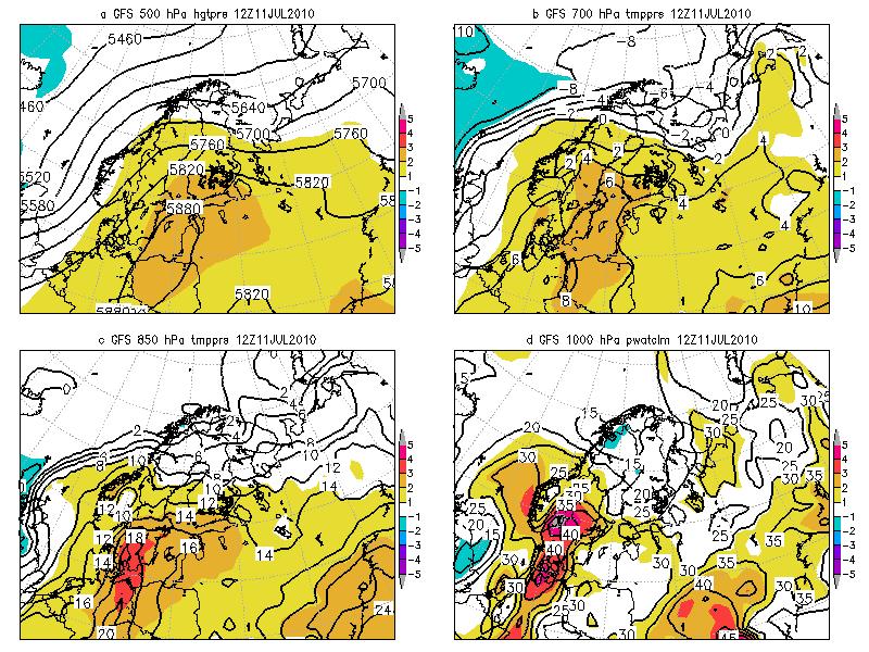
2 In Sweden a news report from 13 July suggested 5 cm hail fell in central portions of the country with local areas of flash flooding. This note will document the heat event and associated pattern during the period of 7-13 July It will be shown that in addition to the strong high latitude extent of the subtropical ridge, there was a surge of high moisture into the air. The above normal precipitable water likely contributed to the extremely warm overnight lows temperatures. 2. METHODS The pattern was reconstructed used the NCEP GFS and were possible the JMA 1.25x1.25 data (Onogi et al. 2007). All data were plotted in GrADS (Doty and Kinter 1995). The focus here is on the pattern over Europe and northern Europe associated with the record and prolonged warm episode. The anomalies were computed from the NCEP/NCAR re-analysis data (Kalnay et al 1996) as describe by Hart and Grumm 2001 and Grumm and Hart Unless otherwise stated, the base data for the means and standard deviations were computed by comparing the GFS to the NCEP/NCAR 30-year climatological values. For brevity times are referred to in the format of 14/1200 for 14 July UTC and 08/0000 UTC for 08 July 2010 at 0000 UTC. 3. RESULTS i. overview Figure 1 shows the large scale view of the pattern from eastern North America into central Europe. Initially, a strong subtropical ridge was present over the eastern Atlantic which moved eastward into Europe (Figs. 1a-d) while a concurrent ridge Date MAX degree C MAX degree F 8-Jul Jul Jul Jul Jul Jul Jul Jul Jul Mean Table 1. High temperatures for Finland. Salo, Kärkkä had the highest value on 11 July. Highest values on 15 & 16 July were set at Kovola. All other temperatures are for either Lammi Evo or Puumala. was present over eastern North America. The ridge over eastern North America peaked on 6-7 July 2010 (Figs. 1b-c). Heights over central Europe peaked over 5880m (Fig. 1f) and showed +2SD height anomalies. Figure 2 shows a European centric 500 hpa height and anomaly field. These data depict the 5880m closed high over Germany on July (Fig. 2f-g) which drifted northward over Russia on 12 July (Fig. 2h) and the weakened extremely high latitude close 5820m upper-level ridge over Finland and Russia by 13/1200 UTC (Fig. 2i). The anomalies with the height center were in the +2 to +3SD range. Figures 3-5 show the 850 hpa temperatures, the precipitable water anomalies, and 700 hpa temperatures The 850 hpa temperatures peaked near 20C over Germany at 11/1200
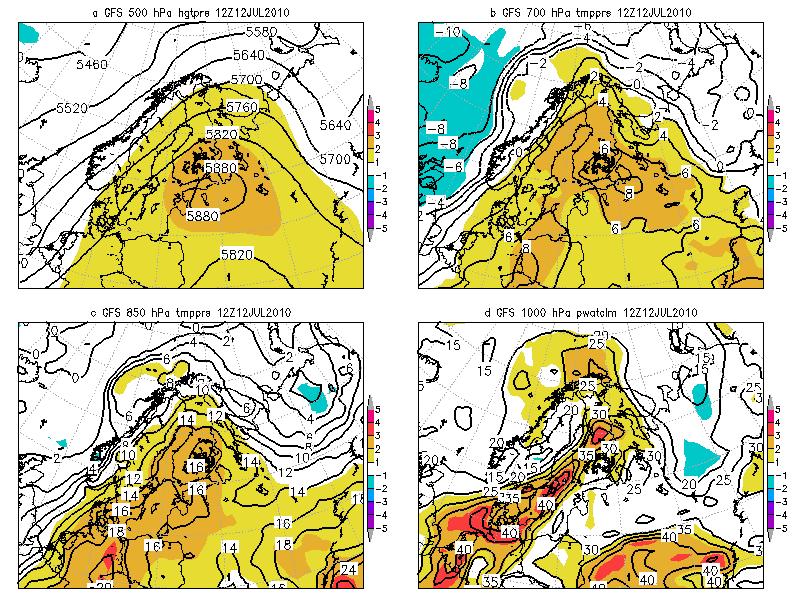
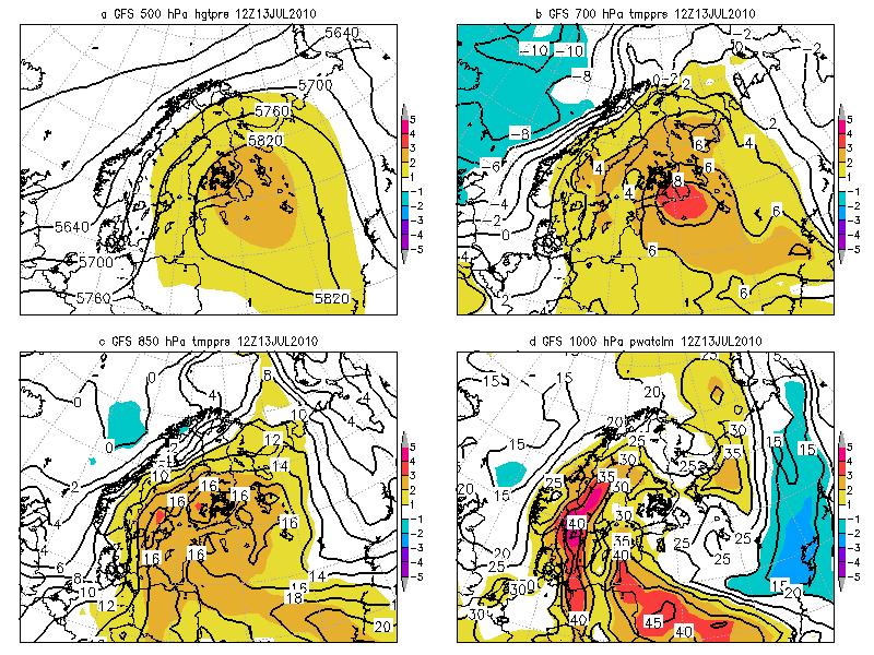
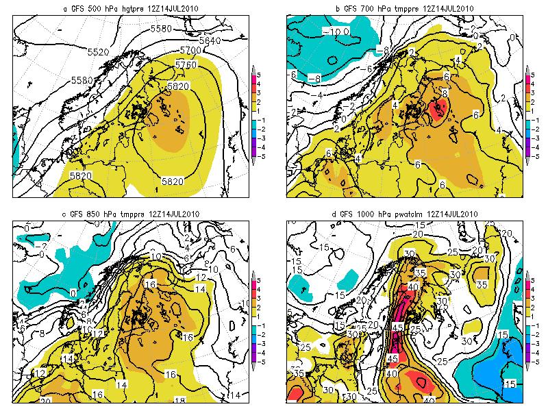
3 UTC (Fig. 3g) which had +3 to +4SD temperature anomalies. The 850 hpa temperatures were about 2C cooler at 12/1200 UTC (Fig. 3h). Over Finland the 850 hpa temperatures rose to 16-18C with +3SD temperature anomalies at times over northern Russia. The precipitable water values were high over most of the heat affected region (Fig. 4). The high moisture content of the air likely increased the capacity of the air to hold heat and produced the tropically warm overnight lows over 20C. A telling heat wave pattern often has deep warm air. Thus, the 700 hpa temperatures are shown in Figure 5. From Poland and into Northern Russia the 700 hpa temperatures above ~5C represent +2SD anomalies (Fig. 5a). These high temperatures would peak over 9C with +3 to +4SD 700 hpa temperature anomalies at 13/1200 UTC. Values over 8C were present at 12/1200 and 13/1200 UTC (Figs. 5h-i). ii. northern European view Figure 6 shows the 500 hpa heights and anomalies over northern Europe from 06/1200 UTC through 14/1200 UTC. The heights peaked between 11/1200 and 12/1200 UTC with a 5880 m contour building into the region. The 5820 m contour and +2SD height anomalies reached southern Finland at this time. The closed 5880 m contour was over Estonia, northeastern Russia and southern Finland at 12/1200 UTC (Fig. 6g). An extensive 5820 m closed high was parked over northern Russia at the end of the period (Fig. 6h-i). Figure 7 shows the 850 hpa temperature over northern Europe. The 18C contour with over 3SD temperature anomalies reached Sweden at 11/1200 UTC (Fig. 7f). The 16C contour extended over northeastern Russia and Finland from 12/1200 through 14/1200 UTC (Figs. 7g-i). The 850 temperatures were generally 2-3SDs above normal with some locally higher values. Figures 9-12 show 4 panel displays of several key fields associated with heat waves and warm episodes. The period from 11/1200 to 14/1200 UTC is covered. These data show the strong subtropical ridge at 500 hpa (Figs. 9a-12a) with large height anomalies; deep warm air with over 2SD 700 hpa and 850 hpa temperatures (Figs. 9b- 12b & Figs. 9c-12c). In addition to the deep warm air and the strong ridge, these data show the high PW air and PW anomalies over the region. PW anomalies peaked at +5SDs above normal at 11/1200 UTC over southern Sweden (Fig. 9d).. 4. CONCLUSIONS A long duration heat wave affected central and northern Europe in July In northern Europe the heat appeared to peak in the 7-15 July 2010 timeframe. The event was associated with unseasonably high midtropospheric temperatures and a large subtropical ridge. Many temperature records for the day were set in northern Europe. Sweden broke a high temperature record which had stood for 257 years. The pattern of this heat event appeared to share the characteristics common to many midlatitude heat events. The most persistent and predictable feature with heat waves is the strong upper-level subtropical ridge. Brugge (1991 & 1995) noted the impact of the subtropical ridge on European and North American heat waves. Galarneau et al. (2008) examined the impact
4 of anticyclones in the subtropics and midlatitudes. They looked specifically at large closed anticyclones and produced climatology of these features. These large ridges are often associated with areas of above normal temperatures and can displace convection into higher latitudes as moisture surges about these features. Heat waves and droughts over North America have been studied by many (Chang and Wallace 1987; Changnon et al. 1996; Kunkel et al. 1996; Livezey et. al 1996; Lyon and Dole 1995; Thwatyes 1995; and Namias 1982). All of these studies relate the event to the large and persistent ridge. Some studies associated the impact of high humidity and persistent heat to impact and fatalities due to the heat (Schar and Jendritzky 2004; Palecki et. al 2001 and Changnon 1996). Goklany (2008) showed that cold and warm episodes account for the largest number of weather related fatalities. Thus, forecasting heat waves and taking precautions are critical to reduce the deaths associated with these costly events. The 2003 European heat wave was estimated to have led to several thousand deaths, mainly of aged people (Schar and Jendritzky 2004). The data shown here suggest that the pattern of this heave event shared the common characteristics of previous mid-latitude heat waves (Lipton et al 2005). This included the deep warm air with temperature anomalies to 700 hpa, a large subtropical ridge and a surge of high PW air over the ridge. The surge of deep moist air can act to keep overnight temperatures high and increase heat stress. As noted in Figure 9, the PW anomalies peaked at +5SDs above normal at 11/1200 UTC over southern Sweden (Fig. 9d). The surge of high PW are about the subtropical ridge is a common feature of mid-latitude heat events. It appears that this feature accompanies high latitude heat episodes too. This likely produced the tropical overnight conditions with lows persistently above 20C. It is known whether there were heat related fatalities. Figure 12 suggests a surge of dry air from the west and a shortwave over the ridge. This may have contributed to the high latitude severe weather experienced in northern Finland on 14 July Yet another characteristic associated with heat waves. Knowing the patterns associated with heat waves is important. Forecasting these patterns is equally important. But perhaps the most important issue is conveying this information to individuals show and reduces the loss of life during these events 5. Acknowledgements New reports from Finland, Germany, and Sweden from various agencies and Yahoo news. Albany map room for information and access to information on the event. Swedish data and generalized weather provided by Sverker Hellström SMHI. Information on Finland provided by Jari Tuovinen, Helsinki, of the Finnish Meteorological Institue. 6. References Brugge, R., 1991: The record-breaking heat wave of 1-4 August 1990 over England and Wales. Weather, 46, Brugge, R., 1995: Heat waves and record temperatures in North America. Weather, 50, Chang F.C., and J.M. Wallace, 1987: Meteorological conditions during heat
5 waves and droughts in the United States Great Plains. Mon. Wea. Rev., 115, Changnon, S. A., K. E. Kunkel, and B. C. Reinke e, 1996: Impacts and Responses to the 1995 Heat Wave: A Call to Action. Bull. Amer. Meteor. Soc., 77, Galarneau, T. J., Jr., L. F. Bosart, and A. R. Aiyyer, 2008: Closed anticyclones of the subtropics and middle latitudes: A 54-yr climatology ( ) and three case studies. Synoptic-Dynamic Meteorology and Weather Analysis and Forecasting: A Tribute to Fred Sanders, Meteor. Monogr., No. 55, Amer. Meteor. Soc., [Available at the AMS Online Store.]. Goklany, I. 2008: Deaths and Death Rates from Extreme Weather Events: Journal of American Physicians and Surgeons 14 (4): (2009). Kunkel, K. E., S. A. Changnon, B. C. Reinke, and R. W. Arritt, 1996: The July 1995 Heat Wave in the Midwest: A Climatic Perspective and Critical Weather Factors. Bull. Amer. Meteor. Soc., 77, Lyon, B., and R. Dole, 1995: A Diagnostic Comparison of the 1980 and 1988 U.S. Summer Heat Wave-Droughts. J. Climate, 8, Namias, J., 1982: Anatomy of Great Plains Protracted Heat waves. Mon. Wea. Rev., 110, Palecki, M. A., S. A. Changnon, and K. E. Kunkel, 2001: The Nature and Impacts of the July 1999 Heat Wave in the Midwestern United States: Learning from the Lessons of Bull. Amer. Meteor. Soc., 82, Robinson, P.J : On the Definition of a Heat Wave. Jour. of Applied Meteor.40, Schar, C., and G. Jendritzky, 2004: Hot news from the summer of Nature, 432, Wagner, J.A., 1981: Weather and circulation of August Mon. Wea.Rev., 108, Thwaytes, R., 1995: Northern Hemisphere heat waves. Weather, 50, Lipton, K., R. Grumm, R. Holmes, P. Knight, and J.R. Ross, 2005: Forecasting Heat waves using climatic anomalies. Pre-prints 21 st Conference on Wea. and Fore. and the 17 th Conference on Numerical Weather Prediction, AMS, Washington, DC. Livezey, R. E., and R. Tinker, 1996: Some Meteorological, Climatological, and Microclimatological Considerations of the Severe U.S. Heat Wave of Mid- July Bull. Amer. Meteor. Soc., 77,
6
 and height anomalies over Europe from forecasts initialized at 1200 UTC a) 5 July,")
7 Figure 1. GFS 00-hour forecasts of 500 hpa height (m) and height anomalies over Europe from forecasts initialized at 1200 UTC a) 5 July, b) 6 July, c) 7 July, d) 8 July, e) 9 July, f) 10 July, g) 11 July, h) 12 July and i) 13 July Return to Intro.
 and height anomalies over Europe from forecasts initialized at 1200 UTC")
8 Figure 2. GFS 00-hour forecasts of 500 hpa height (m) and height anomalies over Europe from forecasts initialized at 1200 UTC a) 5 July, b) 6 July, c) 7 July, d) 8 July, e) 9 July, f) 10 July, g) 11 July, h) 12 July and i) 13 July 2010

9 Figure 3. As in Figure 1 except for 850 hpa temperatures (C ) and temperature anomalies.

10 Figure 4. As in Figure 1 except for precipitable water (mm) and precipitable water anomalies.

11 Figure 5. As in Figure 1 except for 850 hpa temperatures (C ) and temperature anomalies

12 Figure 6. As in Figure 1 except for 500 hpa heights and height anomalies over northern Europe from 1200 UTC 6 to 14 July Return to regional section.

13 Figure 7. As in Figure 6 except for 850 hpa temperatures. Return to regional section.
14
15
16
17
18
The North American Heat Wave of July 2011-Draft
 The North American Heat Wave of July 2011-Draft By Richard H. Grumm And Jason Krekeler 328 Innovation Blvd Suite 330 National Weather Service Office State College, PA 16803 The meteorological conditions
Early May Cut-off low and Mid-Atlantic rains
 Abstract: Early May Cut-off low and Mid-Atlantic rains By Richard H. Grumm National Weather Service State College, PA A deep 500 hpa cutoff developed in the southern Plains on 3 May 2013. It produced a
Impacts of the April 2013 Mean trough over central North America
 Impacts of the April 2013 Mean trough over central North America By Richard H. Grumm National Weather Service State College, PA Abstract: The mean 500 hpa flow over North America featured a trough over
Heat wave ending severe events of July 2010 By Richard H. Grumm National Weather Service Office State College, PA 16803
 Heat wave ending severe events of 23-25 July 2010 By Richard H. Grumm National Weather Service Office State College, PA 16803 1. INTRODUCTION A strong subtropical ridge (Fig. 1a) dominated the eastern
Pre-Christmas Warm-up December 2013-Draft
 Pre-Christmas Warm-up 21-23 December 2013-Draft By Richard H. Grumm National Weather Service State College, PA 1. Overview A large ridge over the west-central Atlantic (Fig.1) and trough moving into eastern
Heavy rains and precipitable water anomalies August 2010 By Richard H. Grumm And Jason Krekeler National Weather Service State College, PA 16803
 Heavy rains and precipitable water anomalies 17-19 August 2010 By Richard H. Grumm And Jason Krekeler National Weather Service State College, PA 16803 1. INTRODUCTION Heavy rain fell over the Gulf States,
Tropical Storm Hermine: Heavy rainfall in western Gulf By Richard H. Grumm National Weather Service Office State College, PA 16803
 Tropical Storm Hermine: Heavy rainfall in western Gulf By Richard H. Grumm National Weather Service Office State College, PA 16803 1. INTRODUCTION Tropical storm Hermine, the eighth named tropical system
Eastern United States Wild Weather April 2014-Draft
 1. Overview Eastern United States Wild Weather 27-30 April 2014-Draft Significant quantitative precipitation bust By Richard H. Grumm National Weather Service State College, PA and Joel Maruschak Over
Multi-day severe event of May 2013
 Abstract: Multi-day severe event of 18-22 May 2013 By Richard H. Grumm and Charles Ross National Weather Service State College, PA A relatively slow moving Trough over the western United States and a ridge
Warm Episode over Indian Sub-continent March 2010 By Richard Grumm National Weather Service State College Contributions by Lance Bosart SUNY Albany
 Warm Episode over Indian Sub-continent March 2010 By Richard Grumm National Weather Service State College Contributions by Lance Bosart SUNY Albany 1. INTRODUCTION A massive subtropical ridge formed over
New Zealand Heavy Rainfall and Floods
 New Zealand Heavy Rainfall and Floods 1. Introduction Three days of heavy rainfall associated with a deep upper-level low (Fig. 1) brought flooding to portions of New Zealand (Fig. 2). The flooding was
Southern United States Heavy rain and flood event 6-8 April 2014
 Southern United States Heavy rain and flood event 6-8 April 2014 By Richard H. Grumm National Weather Service State College, PA 1. Overview Heavy rainfall (Fig. 1) affected the southern United States from
Deep Cyclone and rapid moving severe weather event of 5-6 June 2010 By Richard H. Grumm National Weather Service Office State College, PA 16803
 Deep Cyclone and rapid moving severe weather event of 5-6 June 2010 By Richard H. Grumm National Weather Service Office State College, PA 16803 1. INTRODUCTION A rapidly deepening surface cyclone raced
2 July 2013 Flash Flood Event
 2 July 2013 Flash Flood Event By Richard H. Grumm and Charles Ross National Weather Service State College, PA 1. Overview A retrograding 500 hpa cyclone and anticyclone (Fig. 1) set up deep southerly flow
Warm Episode of December 2015:
 Warm Episode of 11-16 December 2015: Record Warmth over Mid-Atlantic Region By Richard H. Grumm National Weather Service State College, PA 1. Overview A strong 500 hpa ridge over the eastern United States
Early Summer Heat Waves of 2013
 Early Summer Heat Waves of 2013 Abstract: By Richard H. Grumm National Weather Service State College, PA And Trevor Alcott National Weather Service, Salt Lake City Utah From late June into mid-july large
Heavy Rainfall Event of June 2013
 Heavy Rainfall Event of 10-11 June 2013 By Richard H. Grumm National Weather Service State College, PA 1. Overview A 500 hpa short-wave moved over the eastern United States (Fig. 1) brought a surge of
National Weather Service-Pennsylvania State University Weather Events
 National Weather Service-Pennsylvania State University Weather Events Heavy rainfall of 23 November 2011 by Richard H. Grumm National Weather Service State College PA 16803 Abstract:. A fast moving mid-tropospheric
Mid-West Heavy rains 18 April 2013
 Abstract: Mid-West Heavy rains 18 April 2013 By Richard H. Grumm and Charles Ross National Weather Service State College, PA The relatively wet conditions during the first 16 days of April 2013 set the
1. INTRODUCTION. Heat waves are not unique to the United States. Deadly heat waves struck Europe in the summers of 2003 and
 The eastern United States Heat wave of 3-8 July 2010 -Draft By Richard H. Grumm National Weather Service State College, PA 16803 and Kevin Lipton National Weather Service Albany NY 1. INTRODUCTION A sustained
Southern Heavy rain and floods of 8-10 March 2016 by Richard H. Grumm National Weather Service State College, PA 16803
 Southern Heavy rain and floods of 8-10 March 2016 by Richard H. Grumm National Weather Service State College, PA 16803 1. Introduction Heavy rains (Fig. 1) produced record flooding in northeastern Texas
THE EASTERN UNITED STATES HEAT WAVE OF 3-8 JULY Richard H. Grumm NOAA/National Weather Service, Weather Forecast Office, State College, PA and
 P478 THE EASTERN UNITED STATES HEAT WAVE OF 3-8 JULY 2010 Richard H. Grumm NOAA/National Weather Service, Weather Forecast Office, State College, PA and Kevin S. Lipton* NOAA/National Weather Service,
The Big Chill of November 2013
 The Big Chill of November 2013 Value of anomalies for situational awareness By Richard H. Grumm National Weather Service State College, PA Trevor Alcott National Weather Service, Salt Lake City UT 1. Overview
Mid-Atlantic Ice Storm 4 March 2015
 1. Overview Mid-Atlantic Ice Storm 4 March 2015 By Richard H. Grumm National Weather Service State College, PA A large 500 hpa ridge over the southern United States (Fig. 1a-e)) built into the Mid-Atlantic
A summary of the heat episodes of June 2017
 A summary of the heat episodes of June 2017 By Richard H. Grumm and Elissa A. Smith National Weather Service State College, PA 1. Overview Over 1800 record high temperatures were set or tied during the
NWS-PSU Case Study Site 2010 Severe Weather Case
 NWS-PSU Case Study Site 2010 Severe Weather Case New Years Eve Severe Weather Event of 31 December 2010 by Richard H. Grumm National Weather Service State College PA 16083 Abstract: A surge of warm humid
Winter Storm of 15 December 2005 By Richard H. Grumm National Weather Service Office State College, PA 16803
 Winter Storm of 15 December 2005 By Richard H. Grumm National Weather Service Office State College, PA 16803 1. INTRODUCTION A complex winter storm brought snow, sleet, and freezing rain to central Pennsylvania.
National Weather Service-Pennsylvania State University Weather Events
 National Weather Service-Pennsylvania State University Weather Events New Zealand heavy rain and flood event-draft by Richard H. Grumm National Weather Service State College PA 16803 Abstract:. A record
Southern Plains Heavy rain and Flooding
 Abstract: Southern Plains Heavy rain and Flooding By Richard H. Grumm National Weather Service State College, PA A severe weather event affected the southern Plains on 31 May 2013. The severe weather event
National Weather Service-Pennsylvania State University Weather Events
 National Weather Service-Pennsylvania State University Weather Events Eastern United States Winter Storm and Severe Event of 28-29 February 2012 by Richard H. Grumm National Weather Service State College
Alaskan heat episode of June 2013-Draft
 Alaskan heat episode of 16-19 June 2013-Draft Abstract: By Trevor Alcott National Weather Service Western Region, Salt Lake City UT And Richard H. Grumm National Weather Service State College, PA A strong
1. INTRODUCTION. For brevity times are referred to in the format of 20/1800 for 20 August UTC. 3. RESULTS
 Heavy rains and precipitable water anomalies 20-23 August 2010-Draft By Jason Krekeler And Richard Grumm National Weather Service State College, PA 16803 1. INTRODUCTION Heavy rain fell across the central
Orographically enhanced heavy rainfall of 23 May 2010 By Richard H. Grumm National Weather Service Office State College, PA 16803
 Orographically enhanced heavy rainfall of 23 May 2010 By Richard H. Grumm National Weather Service Office State College, PA 16803 1. INTRODUCTION During the overnight hours and into the early morning of
National Weather Service-Pennsylvania State University Weather Events
 National Weather Service-Pennsylvania State University Weather Events The high latitude Eurasian Anticyclone of January-February 2012 by Richard H. Grumm National Weather Service State College PA 16803
National Weather Service-Pennsylvania State University Weather Events
 National Weather Service-Pennsylvania State University Weather Events Abstract: Tropical Storm Debbie, standardized anomalies and heavy rainfall by Richard H. Grumm National Weather Service State College
End of heat-event severe event of 7 July 2012
 End of heat-event severe event of 7 July 2012 Richard H. Grumm And Elyse Colbert National Weather Service Office State College, PA 16803 1. Overview A widespread severe weather event affected Pennsylvania
Eastern Derecho June 2013-Draft
 Abstract: Eastern Derecho 12-13 June 2013-Draft Richard H. Grumm National Weather Service Office State College, PA 16803 A strong mid-tropospheric short-wave coming over a sharp 500 hpa ridge produced
Indiana County Flash Flood of 22 June 2017
 Indiana County Flash Flood of 22 June 2017 By Richard H. Grumm National Weather Service State College, PA 1. Overview Slow moving thunderstorms brought 3 to 4 inches of rainfall to Indiana County, PA during
Memorial Day Weekend 2013: Snow and Cold
 Abstract: Memorial Day Weekend 2013: Snow and Cold By Richard H. Grumm National Weather Service State College, PA A slow moving 500 hpa low and associated unseasonably cold air in the lower troposphere
Northeastern United States Snowstorm of 9 February 2017
 Northeastern United States Snowstorm of 9 February 2017 By Richard H. Grumm and Charles Ross National Weather Service State College, PA 1. Overview A strong shortwave produced a stripe of precipitation
The high latitude blocking and low arctic oscillation values of December 2009
 The high latitude blocking and low arctic oscillation values of December 2009 By Richard H. Grumm National Weather Service Office State College, PA 16803 1. INTRODUCTION An episode of high latitude blocking
The high latitude blocking and impacts on Asia
 The high latitude blocking and impacts on Asia By Richard H. Grumm National Weather Service Office State College, PA 16803 1. INTRODUCTION An episode of high latitude blocking during the month of December
The Devastating Western European Winter Storm February 2010 By Richard H. Grumm National Weather Service
 The Devastating Western European Winter Storm 27-28 February 2010 By Richard H. Grumm National Weather Service 1. INTRODUCTION A strong late winter storm, called Xynthia 1, raced across Western Europe
National Weather Service-Pennsylvania State University Weather Events
 National Weather Service-Pennsylvania State University Weather Events Abstract: West Coast Heavy Precipitation Event of January 2012 by Richard H. Grumm National Weather Service State College PA 16803
Hurricane Alex: Heavy rainfall and anomalous precipitable water By Richard H. Grumm National Weather Service Office State College, PA 16803
 Hurricane Alex: Heavy rainfall and anomalous precipitable water By Richard H. Grumm National Weather Service Office State College, PA 16803 1. INTRODUCTION Hurricane Alex ambled across the Gulf of Mexico
Snow, freezing rain, and shallow arctic Air 8-10 February 2015: NCEP HRRR success story
 Snow, freezing rain, and shallow arctic Air 8-10 February 2015: NCEP HRRR success story By Richard H. Grumm National Weather Service State College, PA 1. Overview A short-wave (Fig. 1) moved over the strong
Southern United States Winter Storm of 28 January 2014-v1. High Impact Snow on Edge of Forecast Precipitation Shield
 Southern United States Winter Storm of 28 January 2014-v1 High Impact Snow on Edge of Forecast Precipitation Shield by Richard H. Grumm National Weather Service State College, PA 16803 and 1. Introduction
NCEP Short-Range Ensemble forecasts of an historic rainfall event: The June 2006 East Coast Floods 1. INTRODUCTION
 NCEP Short-Range Ensemble forecasts of an historic rainfall event: The 23-27 June 2006 East Coast Floods By Richard H. Grumm National Weather Service Office, State College PA 16803 And Norman W. Junker
National Weather Service-Pennsylvania State University Weather Events
 National Weather Service-Pennsylvania State University Weather Events Historic Ohio Valley January Severe weather and Tornado Event by Richard H. Grumm National Weather Service State College PA 16803 and
Mid-Atlantic Derecho event of 29 June 2012
 Mid-Atlantic Derecho event of 29 June 2012 Richard H. Grumm Charles H. Ross And Elyse Colbert National Weather Service Office State College, PA 16803 1. Overview An area of convection developed over eastern
The Deep South snowfall of February 2010 By Richard H. Grumm National Weather Service Office, State College, PA 16803
 The Deep South snowfall of 11-13 February 2010 By Richard H. Grumm National Weather Service Office, State College, PA 16803 1. INTRODUCTION A surface cyclone tracked across Mexico and the Gulf of Mexico
Flooding and Severe weather of 27 June 2013
 Flooding and Severe weather of 27 June 2013 By Richard H. Grumm National Weather Service State College, PA 1. Overview Flooding and severe weather affected Pennsylvania on 27 June 2013 (Fig 1). The severe
Mid-Atlantic Severe Weather Event of 23 June 2015
 Mid-Atlantic Severe Weather Event of 23 June 2015 By Richard H. Grumm National Weather Service State College, PA 1. Overview A widespread severe weather event occurred in the eastern United States on 23
Record snow blankets the United Kingdom 5-6 January 2010
 1. INTRODUCTION Record snow blankets the United Kingdom 5-6 January 2010 By Richard H. Grumm National Weather Service Office State College, PA 16803 A rare winter storm brought heavy snow the United Kingdom
Severe Weather with a strong cold front: 2-3 April 2006 By Richard H. Grumm National Weather Service Office State College, PA 16803
 Severe Weather with a strong cold front: 2-3 April 2006 By Richard H. Grumm National Weather Service Office State College, PA 16803 1. INTRODUCTION A strong cold front brought severe weather to much of
Convective Heavy rainfall event of 23 July 2013
 Convective Heavy rainfall event of 23 July 2013 By Richard H. Grumm and Charles Ross National Weather Service State College, PA Abstract: A record rain event affected southern Lebanon County on 23 July
The Impact of the strong subtropical ridge of 2010
 The Impact of the strong subtropical ridge of 2010 by Richard H. Grumm and Jason Krekeler National Weather Service Office, State College, Pennsylvania And Kevin Lipton National Weather Service Office Albany,
Eastern United States Winter Storm of 1-2 February 2015-DRAFT Northeast Ground Hog Storm
 Eastern United States Winter Storm of 1-2 February 2015-DRAFT Northeast Ground Hog Storm By Richard H. Grumm National Weather Service State College, PA 1. Overview A major Winter Storm brought precipitation
Mid Atlantic Heavy rainfall event 1. Overview 2. Methods and Data 3. Pattern
 1. Overview Mid Atlantic Heavy rainfall event With an inertial gravity wave? By Richard H. Grumm National Weather Service, State College, PA 16803 Contributions from the Albany MAP An unseasonably strong
Severe Weather Event of 13 July 2014
 Severe Weather Event of 13 July 2014 By Richard H. Grumm and Elyse M. Colbert National Weather Service State College, PA 1. Overview Severe weather affected the eastern United States (Fig. 1) from northwestern
The abrupt end of the Persistent Subtropical Ridge of the autumn of 2016
 The abrupt end of the Persistent Subtropical Ridge of the autumn of 2016 1. Introduction by Richard H. Grumm National Weather Service State College, PA 16803 Contributions by Elyse Hagner National Weather
1. INTRODUCTION. The super storm of March 1993 produced severe weather and tornadoes as it s trailing cold front pushed through Florida (Kocin eta 1l
 1. INTRODUCTION Super Tuesday and awful Wednesday: the 5-6 February 2008 Severe Weather Outbreak By Richard H. Grumm National Weather Service State College, PA And Seth Binau National Weather Service,
Mesoscale Convective System and heat episode July 2005 by Richard H. Grumm and Mathew Steinbugl
 Mesoscale Convective System and heat episode 25-27 July 2005 by Richard H. Grumm and Mathew Steinbugl 1. INTRODUCTION A strong upper-level ridge brought unseasonably high temperatures to the Midwest and
Heavy Rainfall and Flooding of 23 July 2009 By Richard H. Grumm And Ron Holmes National Weather Service Office State College, PA 16803
 Heavy Rainfall and Flooding of 23 July 2009 By Richard H. Grumm And Ron Holmes National Weather Service Office State College, PA 16803 1. INTRODUCTION Heavy rains fall over Pennsylvania and eastern New
This paper will document the pattern which produced the record rainfall of 30 September The goal is to show the pattern the
 The Historic Synoptic-Hybrid rainfall event 30 September 2010 By Richard Grumm And Michael Kozar National Weather Service State College, PA 16803 1. INTRODUCTION A slow moving north-south oriented frontal
Minor Winter Flooding Event in northwestern Pennsylvania January 2017
 1. Overview Minor Winter Flooding Event in northwestern Pennsylvania 12-13 January 2017 By Richard H. Grumm National Weather Service State College, PA A combination of snow melt, frozen ground, and areas
1. INTRODUCTION. March. Local time used in text to define dates. 1 Due to UTC time the went passed 0000 UTC 31
 New England Record Maker Rain Event of 29-30 March 2010 By Richard H. Grumm National Weather Service Contributions by Frank Nocera National Weather Service Office Taunton, MA 1. INTRODUCTION The second
Recent Trends in Northern and Southern Hemispheric Cold and Warm Pockets
 Recent Trends in Northern and Southern Hemispheric Cold and Warm Pockets Abstract: Richard Grumm National Weather Service Office, State College, Pennsylvania and Anne Balogh The Pennsylvania State University
Eastern United States Ice Storm of December 2008 By Richard H. Grumm National Weather Service State College, PA 16803
 Eastern United States Ice Storm of 11-12 December 2008 By Richard H. Grumm National Weather Service State College, PA 16803 1. INTRODUCTION A significant ice storm affected the eastern United States on
Patterns of Heavy rainfall in the Mid-Atlantic Region 1. INTRODUCTION
 5A.2 Patterns of Heavy rainfall in the Mid-Atlantic Region by Richard H. Grumm * And Ron Holmes National Weather Service Office State College, PA 16802 1. INTRODUCTION The patterns associated with heavy
National Weather Service-Pennsylvania State University Weather Events
 National Weather Service-Pennsylvania State University Weather Events The February Thaw 17-19 February 2011 by Richard H. Grumm National Weather Service State College PA 16803 Abstract: After a cold January
Winter Storm of February 2008 By Richard H. Grumm National Weather Service Office State College PA 16803
 1. INTRODUCTION Winter Storm of 11-13 February 2008 By Richard H. Grumm National Weather Service Office State College PA 16803 A potent winter storm brought snow, sleet, freezing rain, and rain to the
National Weather Service-Pennsylvania State University Weather Events
 National Weather Service-Pennsylvania State University Weather Events The southern Express: High Impact Spring Storm of 14-17 April 2011 by Richard H. Grumm National Weather Service State College PA 16803
Cold frontal Rainband and Mid-Atlantic Severe Weather Event 28 September 2006 by Richard H. Grumm And Ron Holmes
 Cold frontal Rainband and Mid-Atlantic Severe Weather Event 28 September 2006 by Richard H. Grumm And Ron Holmes 1. INTRODUCTION A strong cold front moved across central Pennsylvania and the Mid-Atlantic
Devastating Tornadoes of 22 May 2011-Draft by Richard H. Grumm National Weather Service State College, PA
 Abstract: Devastating Tornadoes of 22 May 2011-Draft by Richard H. Grumm National Weather Service State College, PA A series of tornadoes struck the central United States on Sunday 22 May 2011. Tornadoes
1. INTRODUCTION. In addition to the severe weather, the
 Anomalous Low and its weather impacts 10-12 May 2008 By Richard Grumm National Weather Service Office State College, PA And Al Cope National Weather Service Office Mount Holly, NJ 1. INTRODUCTION An unusually
1. INTRODUCTION * Figure 1. National Weather Service Storm Prediction Center (SPC) storm reports for December 1, 2006.
 storm reports for December 1, 2006.") P1.14 FORECAST ISSUES RELATED TO THE UNPRECEDENTED SEVERE AND HIGH WIND EVENT OF DECEMBER 2006 by Greg A. DeVoir* and Richard H. Grumm National Weather Service Office State College, PA 16803 1. INTRODUCTION
P1.14 FORECAST ISSUES RELATED TO THE UNPRECEDENTED SEVERE AND HIGH WIND EVENT OF DECEMBER 2006 by Greg A. DeVoir* and Richard H. Grumm National Weather Service Office State College, PA 16803 1. INTRODUCTION
Thanksgiving Eve snow of November 2014
 1. Overview Thanksgiving Eve snow of 26-27 November 2014 By Richard H. Grumm National Weather Service State College, PA An early season east coast winter storm (ECWS: DeGaetano et al. 2002) brought snow
1995 and 1980 (exact dates would be useful). 1. INTRODUCTION
. 1. INTRODUCTION") Alaskan Autumn Storm of 22-24 November 2010 By Richard Grumm National Weather Service State College, PA 16803 and Rick Thoman and James A. Nelson National Weather Service Alaska Region 1. INTRODUCTION
Alaskan Autumn Storm of 22-24 November 2010 By Richard Grumm National Weather Service State College, PA 16803 and Rick Thoman and James A. Nelson National Weather Service Alaska Region 1. INTRODUCTION
record highs. Daily high temperature records were set at most climatic sites in the region. 1. INTRODUCTION
 Early January 2007 Warm Episode and Record Warmth of 6 January By Richard H. Grumm, Ron Holmes, And Michael Connelly National Weather Service Office State College PA 16803 1. INTRODUCTION The winter of
The Pennsylvania Observer
 The Pennsylvania Observer October 1, 2015 September 2015 - Pennsylvania Weather Recap By: Quinn Lease The month of September will be remembered for its above normal temperatures and dry conditions that
The enduring Louisiana rain and flooding of August 2016 by Richard H. Grumm National Weather Service State College, PA 16803
 1. Introduction The enduring Louisiana rain and flooding of August 2016 by Richard H. Grumm National Weather Service State College, PA 16803 Historic flooding impacted Louisiana on 12-15 August 2016 (TWC
Arkansas Flash Floods and heavy rainfall-draft By Richard H. Grumm National Weather Service State College PA 16803
 Arkansas Flash Floods and heavy rainfall-draft By Richard H. Grumm National Weather Service State College PA 16803 1. INTRODUCTION Training convection associated with deep moisture and a strongly southerly
2. Methods and data. 1 NWS Reno, NV report circulated in the LA Times story maximum wind was observed at 0900 AM 8 January 2017.
 The California Extreme Precipitation Event of 8-10 January 2017 By Richard H. Grumm and Charles Ross National Weather Service State College, PA 16803 1. Introduction A strong Pacific jet and a surge of
The southern express: Winter storm of January 2010 By Richard H. Grumm National Weather Service
 The southern express: Winter storm of 28-30 January 2010 By Richard H. Grumm National Weather Service 1. INTRODUCTION A storm system of Pacific origin tracked across the southern United States from 27-31
The Arctic Outbreak of 4-8 January 2014
 The Arctic Outbreak of 4-8 January 2014 by Richard H. Grumm National Weather Service State College, PA 16803 1. INTRODUCTION An artic outbreak affected much of eastern North American to include the eastern
The Long-lived eastern US tornadic supercell of 20 July 2017
 1. Overview The Long-lived eastern US tornadic supercell of 20 July 2017 By Richard H. Grumm and Elissa A Smith National Weather Service State College, PA A long lived supercell developed near the eastern
The Devastating Mid-Mississippi Valley Floods of 1-2 May 2010 By Richard H. Grumm National Weather Service
 The Devastating Mid-Mississippi Valley Floods of 1-2 May 2010 By Richard H. Grumm National Weather Service 1. INTRODUCTION A devastating heavy rainfall event affected the Mid-Mississippi Valley (MMV) from
HRRR and the Mid-Mississippi Valley Severe and Heavy rainfall event of October 2014
 HRRR and the Mid-Mississippi Valley Severe and Heavy rainfall event of 13-14 October 2014 By Richard H. Grumm National Weather Service State College, PA contributions by Charles Ross 1. Overview A deep
Ensemble Forecasts of the Blizzard of January 2005 By Richard H. Grumm National Weather Service State College Pennsylvania
 Ensemble Forecasts of the Blizzard of 22-23 January 2005 By Richard H. Grumm National Weather Service State College Pennsylvania 1. Introduction A fast moving upper-level disturbance produced a wide area
The Severe Weather Event of 7 August 2013 By Richard H. Grumm and Bruce Budd National Weather Service State College, PA 1. INTRODUCTION and Overview
 The Severe Weather Event of 7 August 2013 By Richard H. Grumm and Bruce Budd National Weather Service State College, PA 1. INTRODUCTION and Overview A fast moving short-wave (Fig. 1) with -1σ 500 hpa height
National Weather Service-Pennsylvania State University Weather Events
 National Weather Service-Pennsylvania State University Weather Events The record eastern United States Severe Weather event of 3-4 April 2011-Draft by Richard H. Grumm National Weather Service State College
MJO Influence in Continental United States Temperatures
 MJO Influence in Continental United States Temperatures An honors thesis presented to the Department of Atmospheric Science, University at Albany, State University Of New York in partial fulfillment of
National Weather Service-Pennsylvania State University Weather Events
 National Weather Service-Pennsylvania State University Weather Events Southern Express 18-19 February 2012: Probabilities, Potentials and uncertainty by Richard H. Grumm National Weather Service State
East Coast Heavy Rainfall of January 2010 By Richard H. Grumm National Weather Service
 1. INTRODUCTION A strong storm moved across the United States from 21 January through 25 January 2010 (Fig. 1). This storm produced record rainfall and snowfall in the western United States from 20-22
Anticipating record events using patterns and pattern forecast: Mid-Mississippi Valley floods of April 2011
 Anticipating record events using patterns and pattern forecast: Mid-Mississippi Valley floods of April 2011 Richard H. Grumm National Weather Service State College, PA Abstract: A persistent pattern produced
1. INTRODUCTION: 2. DATA AND METHODOLOGY:
 27th Conference on Hurricanes and Tropical Meteorology, 24-28 April 2006, Monterey, CA 3A.4 SUPERTYPHOON DALE (1996): A REMARKABLE STORM FROM BIRTH THROUGH EXTRATROPICAL TRANSITION TO EXPLOSIVE REINTENSIFICATION
Mid Atlantic Severe Event of 1 May 2017 Central Pennsylvania QLCS event By Richard H. Grumm National Weather Service, State College, PA 16803
 1. Overview Mid Atlantic Severe Event of 1 May 2017 Central Pennsylvania QLCS event By Richard H. Grumm National Weather Service, State College, PA 16803 A strong upper-level wave (Fig.1) moving into a
Hurricane Harvey the Name says it all. by Richard H. Grumm and Charles Ross National Weather Service office State College, PA
 Hurricane Harvey the Name says it all by Richard H. Grumm and Charles Ross National Weather Service office State College, PA 16803. 1. Overview Hurricane Harvey crossed the Texas coast (Fig. 1) as a category
Eastern United States Anafrontal Snow 4-5 March 2015-Draft
 Eastern United States Anafrontal Snow 4-5 March 2015-Draft By Richard H. Grumm National Weather Service State College, PA 1. Overview A 500 hpa ridge over the western Atlantic (Fig. 1) and an approaching