2. Methods and data. 1 NWS Reno, NV report circulated in the LA Times story maximum wind was observed at 0900 AM 8 January 2017.
|
|
|
- Juliet Pope
- 5 years ago
- Views:
Transcription
1 The California Extreme Precipitation Event of 8-10 January 2017 By Richard H. Grumm and Charles Ross National Weather Service State College, PA Introduction A strong Pacific jet and a surge of high precipitable water (PW: Fig. 1) brought extremely heavy precipitation to portions of California on 8-9 January 2017 (Fig. 2). Rainfall amounts in excess of 200 mm were observed and there were reports of extreme snowfall to include. NBC news reported epic snowfall in the Sierras. The Los Angeles Times reported flooding, record snow, extremely high winds at higher elevations, extreme snowfall, and blizzard conditions in the Sierras on 8-9 January Squaw Valley reported winds of 99 MPH with gusts as high as 159 MPH 1. The strong Pacific system was associated with a near classic pattern for significant precipitation events in California which included a surge of high PW (Fig. 1) also known as an atmospheric river (AR: Neiman et al. 2008), a deep trough off the West Coast, a strong Ridge over the north Pacific and a ridge to the east (Fig. 3). This results in a strong 250 hpa jet (Fig. 4) moving into then over the affected region (Junker et al. 2008). It will be shown that the general pattern was well forecast and thus the NCEP GEFS was able to forecast the general regions of heavy rain in California. This probably was an easy forecast as the mountains act as fixed forcing for the impinging moisture and energy from the Pacific. This paper will provide an overview of the event and examine NCEP GEFS forecasts of the QPF. This was a multi-day event and the focus was on the heavy precipitation from 0000 UTC 8 to 0000 UTC 10 January. There was a significant event prior to this and another surge of precipitation after this time. 2. Methods and data The climate forecast system re-analysis (CFSR) and Global Forecast System (GFS) data were used to reconstruct the pattern and the standardized anomalies associated with the event. Most of the data is focused to the time leading up to the event and during the height of the event. It should be noted that all times are GMT and the region is GMT-8. Thus all dates will be described based on GMT times which are nearly half a day off the local calendar date. The Stage-IV rainfall data (Seo 1998) was used to estimate the rainfall over several 6, 12 and 24, monthly, and case related discrete times to show the impact of the pattern changing rainfall event. The rainfall pattern also revealed some interesting information about the southeastern drought and how both meteorologically and climatologically significant the precipitation event of November 2016 was for the southeastern United States. 1 NWS Reno, NV report circulated in the LA Times story maximum wind was observed at 0900 AM 8 January
2 Forecasts from the NCEP GEFS are the primary source here. The GEFS data was stored in GRIB2 format and processed using GrADS. Many of the images produced were produced in real-time in single panel images. They were reproduced here using a 6-panel format to facilitate the comparison of 6 GEFS forecast cycles spanning 6 days. This left the possibility of using 24 different GEFS forecast cycles. Nearly all the images shown here are either from the 0000 and 1200 UTC cycles. To get to longer ranges these data too were thinned from a potential of 12 to 6 times. Images of various other cycle times were made and showed a similar signal. 3. Results a. The Large scale patter The 500 hpa pattern over the northeastern Pacific (Fig. 3c) showed the basic pattern described by Junker et al. (2008). There was a large 500 hpa ridge over the Aleutians with 500 hpa height anomalies during the onset stage on the order of +2 to +4σ above normal. A strong 500 hpa trough (short-wave) moving down the eastern side of the ridge eventually produced a strong 500 hpa gradient along the California coast. This gradient was in part associated with the large 500 hpa ridge over the Mexico and the adjacent southeastern Pacific Ocean on the edge of the images. In this strong gradient between the 500 hpa trough and the 500 hpa ridge a strong 250 hpa jet was present (Fig. 4). The plume of deep Pacific moisture is depicted in the PW field over the region (Fig. 1) which shows the deep subtropical Pacific connection of the AR and the commonly phrased pineapple express. A regional perspective of the PW plume and 700 hpa jet impinging on the California is provide in 6-hour increments in Figures 5 & 6. Figure 5 shows the PW and PW anomalies focused over the period of heavy precipitation. Note the PW values in the +5 to +6σ range at 0000 UTC, 0600 UTC and 1200 UTC 8 January The PW values peaked again at +5σ at 0600 UTC 09 January These data show and enduring surge of Pacific moisture. The strong 700 hpa jet maximized slightly later in the period in the 1200 UTC 8 January to 0000 UTC 9 January time frame (Fig. 6c-e). Figure 7 shows several of the key features which played a role in the event at 0000 UTC 9 January 2017.These data show a deep trough off the coast British Columbia, the strong ridge off the Mexican Coast (Fig. 7a), the strong low-level jet (Fig. 7b) over the Pacific impinging on California, the deep PW plume (Fig. 7c), and the deep surface cyclone (Fig. 7d) relatively well aligned with the deep 500 hpa cyclone. b. Forecasts The GEFS forecasts of 150 mm or more QPF for the 48 hours valid at 0000 UTC 10 January 2017 (Fig. 8) show that the GEFS was forecasting the potential for over 6 inches of QPF in the region close to the area where the highest QPF was analyzed by the Stage-IV data. The black dot is the approximate location of Mammoth Mountain where reports of 7 feet of snow were observed. This point is slightly east of the GEFS axis of maximum QPF. 2
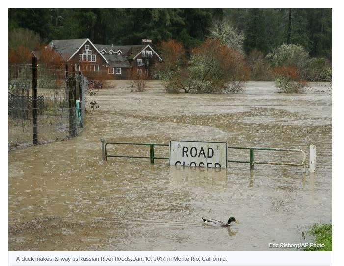
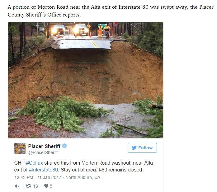
3 The 150 mm of QPF (6 inches) was likely due to the continuous flow of deep moisture the GEFS members produced into the terrain of California. The ensemble means PW and PW anomalies (Fig. 9) show the high PW plume impinging on the Sierras. These data are valid at 1800 UTC 8 January. Other times from 0000 UTC 8 January through about 1200 UTC 9 January showed a similar pattern with high PW air impinging on the mountains. The continuous flow of moisture and strong winds (not shown) produced high QPF amounts over several periods. The first 24 hour period from 0000 UTC 8-9 January (Fig. 10) showed a high probability of over 100 mm of QPF from most of the GEFS cycles. The 1200 UTC 3 January 2017 forecast had lower probabilities but they came up steadily as the forecast length decreased suggesting a convergence of solutions over time. The probability of over 150 mm of QPF in 36 hours ending at 1200 UTC 9 January (Fig. 11) show higher confidence in the higher QPF amounts. These data indicated the issues with uncertainty related to spatial and temporal issues in the various GEFS cycles. Some of the earlier GEFS forecasts had a slightly later onset time of the higher QPF amounts. The final image (Fig.12) in the sequence shows the ensemble mean QPF for each GEFS cycle and the location of each member s 200 mm contour if present in the forecasts. In these cases every GEFS forecast had at least 1 member which produced at least 200 mm (8 inches) of QPF. The final point is what did these QPF represent in the GEFS atmosphere relative to its internal QPF climate? The forecasts suggest the GEFS was producing record QPF over portions of California for many time periods. One example if provided using the GEFS initialized at 0000 UTC 5 January 2017 showing the 48 hour forecast valid at 1200 UTC 9 January 2017 (Fig. 13- right). These data show the GEFS mean QPF was over 6 inches and that for this time period and this time of year the GEFS was forecast a record QPF event. This was true of nearly every forecast cycle valid during the time period of 0000 UTC 8 to 0000 UTC 10 January 2017 (not shown). The forecasts from 0000 UTC 4 January are included as an additional 48 hour forecast example. c. Impacts This storm brought a wide range of impacts to northern California. There were widespread reports of small stream flooding across the entire region (ABC News). For example, Alta, in Placer County in the foothills east of Sacramento had a portion of Morton Road wash out. South of Sacramento, in Wilton the Cosumnes River flooded (Sacramento Bee), prompting a voluntary evacuation of around 2000 people. Water levels reached their highest levels since North of San Francisco, the Russian River crested well above flood stage with close to 3000 residence forced to evacuate in Sonoma County. The Sacramento Weir, a flood control structure aimed to prevent flooding in and around Sacramento, on the Sacramento River, was opened for the first time in a decade spilling water onto farmland known as the Yolo bypass between Sacramento and Davis California. Snowfall in the Sierra Nevada Mountains was copious. After years of drought this is welcome news, however it has created significant impacts for the time being. Over seven plus feet of 3
4 snow fell over the higher elevations, and mountain highways including Interstate 80 and US Highway 50 were closed for long stretches. There were numerous reports of rescues of stranded motorists. A positive impact awaits the region as when the interstates and ski resorts reopen, there will be epic powder skiing for Sierra resorts for days and the snow pack will help restore low water levels produced by the enduring drought. Finally, one F0 tornado was recorded north of Sacramento in South Natomas, producing tree and minor structural damage.. 4. Conclusions The pattern as shown in Figure 7 was a classic West Coast heavy precipitation pattern as defined by Junker et al. (2008). Key features as shown at 0000 UTC 9 January 2017 included the deep trough off the coast British Columbia, the strong ridge off the Mexican Coast (Fig. 9a), the strong low-level jet (Fig. 9b) over the Pacific impinging on California, the deep PW plume (Fig. 9c), and the deep surface cyclone (Fig. 9d) relatively well aligned with the deep 500 hpa cyclone. The GEFS and other models (not shown) were able to correctly forecast the pattern in which this extreme if note epic QPF event developed in. The pattern was nearly a textbook example of the pattern identified by Junker et al (2008). As the GEFS was capable of producing the pattern and strong onshore flow it was also able to produce the extreme QPF amounts (Figs ). And as shown in Figure 13, the GEFS was producing record QPF within the forecast system. It was probably helpful to the GEFS that the mountains of California and Nevada represent fixed forcing. Thus the GEFS had an extremely long lead-time of an extreme QPF event. The QPFs in the GEFS relative to the GEFS internal Climate (M-Climate) were extremely useful. Clearly, internal model climate data plays a critical forecast role in forecasting extreme QPF events. Experience using model QPF and M-Climate data clearly shows that when the models and ensemble forecasts systems forecast a record event in the model climate, record and at times historic events are often observed in the real atmosphere. Developing M-Climate data for global forecast systems is a critical tool in the forecaster s arsenal when forecasting record events. The focus here was on one period of heavy QPE and QPF. As shown in Figure 14, this was an enduring event with several surges of high QPF. The areas of higher QPF shifted as the plume of deep moisture moved over time. The higher QPF amounts occurred in the 24 hour periods ending 1200 UTC 9 January and 1200 UTC 11 January. The enduring nature of this event implies some time averaging of the features may provide added insights. Clearly, a relatively persistent pattern played a role in this epic event. The mean pattern for the period of 0000 UTC 8 to 1800 UTC 10 January is shown in Figure 15. In a relative sense it contains all the key feature often associated with historic California QPE events just they persisted for several days. This image will be updated as 11 January CFSRV2 data comes in. 4
5 5. References Junker, N. W., R. H. Grumm, R. Hart, L. F. Bosart, K. M. Bell, and F. J. Pereira, 2008: Use of standardized anomaly fields to anticipate extreme rainfall in the mountains of northern California. Wea. Forecasting,23, Neiman, P.J., F.M. Ralph, G.A. Wick, J. D. Lundquist, and M. D. Dettinger, 2008: Meteorological characteristics and overland precipitation impacts of atmospheric rivers affecting the west coast of North America based on eight years of SSMI/satellite observations. J. Hydrometeor., 9, Seo, D.-J., C.R. Kondragunta, K. Howard, S.V. Vasiloff and J. Zhang, 2005: The National Mosaic and Multisensor QPE (NMQ) Project Status and plans for a community testbed for high-resolution multisensor quantitative precipitation estimation (QPE) over the United States. Preprints, AMS 19 th Conference on Hydrology, San Diego, CA. Paper
6 6
 over the eastern Pacific in 12 hour increments from a) 0000 UTC 7 to f) 1200 UTC 9")
7 Figure 1. The CFSRV2 precipitable water (mm) over the eastern Pacific in 12 hour increments from a) 0000 UTC 7 to f) 1200 UTC 9 January Values in mm plot every 5mm and standardized anomalies relative to the 30 year mean. Return to text. 7

8 Figure 2. Total QPE from the Stage-IV data for the period of 0000 UTC 8 to 10 January Black do is the location of Mammoth Mountain. Return to text. 8
 0000 UTC 7 January through")
9 Figure 3. As in Figure 1 except for the 500 hpa heights and height anomalies from a) 0000 UTC 7 January through f) 1200 UTC 9 January 2017 in 12 hour increments. Contours are every 60 m. Return to text. 9

10 Figure 4. As in Figure 3 except for the 250 hpa winds over the eastern Pacific and western United States. Isotachs shading as in color bar and the isotachs values are every 10ms-1. Return to text. 10

11 Figure 5. As in Figure 3 except regional view of the CFS Precipitable water in 6 hour increments from a) 0000 UTC 8 January to January 2017 in 6-hour increments. Return to text. 11
 shading shows")
12 Figure 6. As in Figure 5 except for 700 hpa winds (ms-1) shading shows the values indicated in the color bar. Return to text. 12
 500 hpa heights and anomalies, b) 850 hpa winds and u- wind")
13 Figure 7. As in Figure 6 except for CFSR at 0000 UTC 9 January 2017 showing a) 500 hpa heights and anomalies, b) 850 hpa winds and u- wind anomalies, c) precipitable water and anomalies, and d) mean sea-level pressure an pressure anomalies. Return to text. 13
14 Figure 8. GEFS forecast of QPF greater than or equal to 150 mm (shaded) for the 48 hour period ending at 10 January Solid line shows the mean 150 mm contour if present. GEFS forecasts initialized at a) 1200 UTC 3 January, b) 1200 UTC 4 January, c) 1200 UTC 5 January, d) 1200 UTC 6 January, e) 0000 UTC 7 January, and f) 1200 UTC 7 January Return to text. 14

15 Figure 9. As in Figure 8 except GEFS forecasts of ensemble mean precipitable water and precipitable water anomalies valid at 1800 UTC 8 January Values of PW in mm. Return to text. 15
16 Figure 10. As in Figure 8 except GEFS forecasts of the probability of 100 mm of QPF valid for the 24 hour period ending at 0000 UTC 09 January Return to text. 16
17 Figure 11. As in Figure 8 except GEFS forecasts of the probability of 100 mm of QPF valid for the 36 hour period ending at 1200 UTC 09 January Return to text. 17

18 Figure 12. As in Figure 8 except GEFS ensemble mean QPF for the 48 hour period ending at 0000 UTC 10 January 2017 and the position of any members 200 mm contour if forecast. Return to text. 18

19 Figure 13. The GEFS ensemble mean QPF and the location in the PDF of this QPF verse the M-Climate from the GEFS QPF climatology for 48 hour forecasts valid in early January. Data shown include the 48-h QPF valid from 0000 UTC 8 to 0000 UTC 10 January Return to text. 19
 6 January, b) 7")
20 Figure 14. As in Figure 2 except for the 24 hour total QPE for the 6 times ending at 1200 UTC a) 6 January, b) 7 January, c) 8 January, d) 9 January, e) 10 January, and f) 11 January 2017, Return to text. 20

21 Figure 15. As in Figure 7 except for the pattern over the period from 0000 UTC 8 to 1800 UTC 10 January Return to text. 21
22 22
National Weather Service-Pennsylvania State University Weather Events
 National Weather Service-Pennsylvania State University Weather Events Abstract: West Coast Heavy Precipitation Event of January 2012 by Richard H. Grumm National Weather Service State College PA 16803
Southern Heavy rain and floods of 8-10 March 2016 by Richard H. Grumm National Weather Service State College, PA 16803
 Southern Heavy rain and floods of 8-10 March 2016 by Richard H. Grumm National Weather Service State College, PA 16803 1. Introduction Heavy rains (Fig. 1) produced record flooding in northeastern Texas
New Zealand Heavy Rainfall and Floods
 New Zealand Heavy Rainfall and Floods 1. Introduction Three days of heavy rainfall associated with a deep upper-level low (Fig. 1) brought flooding to portions of New Zealand (Fig. 2). The flooding was
2 July 2013 Flash Flood Event
 2 July 2013 Flash Flood Event By Richard H. Grumm and Charles Ross National Weather Service State College, PA 1. Overview A retrograding 500 hpa cyclone and anticyclone (Fig. 1) set up deep southerly flow
National Weather Service-Pennsylvania State University Weather Events
 National Weather Service-Pennsylvania State University Weather Events Abstract: Tropical Storm Debbie, standardized anomalies and heavy rainfall by Richard H. Grumm National Weather Service State College
Mid-West Heavy rains 18 April 2013
 Abstract: Mid-West Heavy rains 18 April 2013 By Richard H. Grumm and Charles Ross National Weather Service State College, PA The relatively wet conditions during the first 16 days of April 2013 set the
Pre-Christmas Warm-up December 2013-Draft
 Pre-Christmas Warm-up 21-23 December 2013-Draft By Richard H. Grumm National Weather Service State College, PA 1. Overview A large ridge over the west-central Atlantic (Fig.1) and trough moving into eastern
National Weather Service-Pennsylvania State University Weather Events
 National Weather Service-Pennsylvania State University Weather Events New Zealand heavy rain and flood event-draft by Richard H. Grumm National Weather Service State College PA 16803 Abstract:. A record
National Weather Service-Pennsylvania State University Weather Events
 National Weather Service-Pennsylvania State University Weather Events Heavy Rain 7-8 December 2011 by Richard H. Grumm National Weather Service State College PA 16803 Abstract:. A mid-level short-wave
Northeastern United States Snowstorm of 9 February 2017
 Northeastern United States Snowstorm of 9 February 2017 By Richard H. Grumm and Charles Ross National Weather Service State College, PA 1. Overview A strong shortwave produced a stripe of precipitation
Hurricane Harvey the Name says it all. by Richard H. Grumm and Charles Ross National Weather Service office State College, PA
 Hurricane Harvey the Name says it all by Richard H. Grumm and Charles Ross National Weather Service office State College, PA 16803. 1. Overview Hurricane Harvey crossed the Texas coast (Fig. 1) as a category
Impacts of the April 2013 Mean trough over central North America
 Impacts of the April 2013 Mean trough over central North America By Richard H. Grumm National Weather Service State College, PA Abstract: The mean 500 hpa flow over North America featured a trough over
Tropical Storm Hermine: Heavy rainfall in western Gulf By Richard H. Grumm National Weather Service Office State College, PA 16803
 Tropical Storm Hermine: Heavy rainfall in western Gulf By Richard H. Grumm National Weather Service Office State College, PA 16803 1. INTRODUCTION Tropical storm Hermine, the eighth named tropical system
National Weather Service-Pennsylvania State University Weather Events
 National Weather Service-Pennsylvania State University Weather Events Heavy rainfall of 23 November 2011 by Richard H. Grumm National Weather Service State College PA 16803 Abstract:. A fast moving mid-tropospheric
Minor Winter Flooding Event in northwestern Pennsylvania January 2017
 1. Overview Minor Winter Flooding Event in northwestern Pennsylvania 12-13 January 2017 By Richard H. Grumm National Weather Service State College, PA A combination of snow melt, frozen ground, and areas
Heavy Rainfall Event of June 2013
 Heavy Rainfall Event of 10-11 June 2013 By Richard H. Grumm National Weather Service State College, PA 1. Overview A 500 hpa short-wave moved over the eastern United States (Fig. 1) brought a surge of
Heavy rains and precipitable water anomalies August 2010 By Richard H. Grumm And Jason Krekeler National Weather Service State College, PA 16803
 Heavy rains and precipitable water anomalies 17-19 August 2010 By Richard H. Grumm And Jason Krekeler National Weather Service State College, PA 16803 1. INTRODUCTION Heavy rain fell over the Gulf States,
Early May Cut-off low and Mid-Atlantic rains
 Abstract: Early May Cut-off low and Mid-Atlantic rains By Richard H. Grumm National Weather Service State College, PA A deep 500 hpa cutoff developed in the southern Plains on 3 May 2013. It produced a
Southern United States Heavy rain and flood event 6-8 April 2014
 Southern United States Heavy rain and flood event 6-8 April 2014 By Richard H. Grumm National Weather Service State College, PA 1. Overview Heavy rainfall (Fig. 1) affected the southern United States from
West Coast Multi-Day heavy Precipitation Event 28 November-2 December 2012-Draft
 West Coast Multi-Day heavy Precipitation Event 28 November-2 December 2012-Draft By Richard H. Grumm and Charles Ross National Weather Service State College, PA 16803 Contributions by the Albany MAP and
Alaskan heat episode of June 2013-Draft
 Alaskan heat episode of 16-19 June 2013-Draft Abstract: By Trevor Alcott National Weather Service Western Region, Salt Lake City UT And Richard H. Grumm National Weather Service State College, PA A strong
Winter Storm of 15 December 2005 By Richard H. Grumm National Weather Service Office State College, PA 16803
 Winter Storm of 15 December 2005 By Richard H. Grumm National Weather Service Office State College, PA 16803 1. INTRODUCTION A complex winter storm brought snow, sleet, and freezing rain to central Pennsylvania.
Snow, freezing rain, and shallow arctic Air 8-10 February 2015: NCEP HRRR success story
 Snow, freezing rain, and shallow arctic Air 8-10 February 2015: NCEP HRRR success story By Richard H. Grumm National Weather Service State College, PA 1. Overview A short-wave (Fig. 1) moved over the strong
The Deep South snowfall of February 2010 By Richard H. Grumm National Weather Service Office, State College, PA 16803
 The Deep South snowfall of 11-13 February 2010 By Richard H. Grumm National Weather Service Office, State College, PA 16803 1. INTRODUCTION A surface cyclone tracked across Mexico and the Gulf of Mexico
Indiana County Flash Flood of 22 June 2017
 Indiana County Flash Flood of 22 June 2017 By Richard H. Grumm National Weather Service State College, PA 1. Overview Slow moving thunderstorms brought 3 to 4 inches of rainfall to Indiana County, PA during
Eastern United States Wild Weather April 2014-Draft
 1. Overview Eastern United States Wild Weather 27-30 April 2014-Draft Significant quantitative precipitation bust By Richard H. Grumm National Weather Service State College, PA and Joel Maruschak Over
Memorial Day Weekend 2013: Snow and Cold
 Abstract: Memorial Day Weekend 2013: Snow and Cold By Richard H. Grumm National Weather Service State College, PA A slow moving 500 hpa low and associated unseasonably cold air in the lower troposphere
The enduring Louisiana rain and flooding of August 2016 by Richard H. Grumm National Weather Service State College, PA 16803
 1. Introduction The enduring Louisiana rain and flooding of August 2016 by Richard H. Grumm National Weather Service State College, PA 16803 Historic flooding impacted Louisiana on 12-15 August 2016 (TWC
Mid Atlantic Severe Event of 1 May 2017 Central Pennsylvania QLCS event By Richard H. Grumm National Weather Service, State College, PA 16803
 1. Overview Mid Atlantic Severe Event of 1 May 2017 Central Pennsylvania QLCS event By Richard H. Grumm National Weather Service, State College, PA 16803 A strong upper-level wave (Fig.1) moving into a
A summary of the heat episodes of June 2017
 A summary of the heat episodes of June 2017 By Richard H. Grumm and Elissa A. Smith National Weather Service State College, PA 1. Overview Over 1800 record high temperatures were set or tied during the
Hurricane Alex: Heavy rainfall and anomalous precipitable water By Richard H. Grumm National Weather Service Office State College, PA 16803
 Hurricane Alex: Heavy rainfall and anomalous precipitable water By Richard H. Grumm National Weather Service Office State College, PA 16803 1. INTRODUCTION Hurricane Alex ambled across the Gulf of Mexico
The southern express: Winter storm of January 2010 By Richard H. Grumm National Weather Service
 The southern express: Winter storm of 28-30 January 2010 By Richard H. Grumm National Weather Service 1. INTRODUCTION A storm system of Pacific origin tracked across the southern United States from 27-31
New England Record Maker Rain Event of March 2010
 National Weather Association, Electronic Journal of Operational Meteorology, 2011-EJ4 New England Record Maker Rain Event of 29-30 March 2010 RICHARD H. GRUMM National Weather Service, State College, PA
This paper will document the pattern which produced the record rainfall of 30 September The goal is to show the pattern the
 The Historic Synoptic-Hybrid rainfall event 30 September 2010 By Richard Grumm And Michael Kozar National Weather Service State College, PA 16803 1. INTRODUCTION A slow moving north-south oriented frontal
Historic Eastern United States Winter Storm of January 2016: Record snow along the megalopolitan corridor 1. Introduction
 Historic Eastern United States Winter Storm of 22-24 January 2016: Record snow along the megalopolitan corridor by Richard H. Grumm National Weather Service State College, PA 16803 1. Introduction An historic
Southern Plains Heavy rain and Flooding
 Abstract: Southern Plains Heavy rain and Flooding By Richard H. Grumm National Weather Service State College, PA A severe weather event affected the southern Plains on 31 May 2013. The severe weather event
Mid-Atlantic Ice Storm 4 March 2015
 1. Overview Mid-Atlantic Ice Storm 4 March 2015 By Richard H. Grumm National Weather Service State College, PA A large 500 hpa ridge over the southern United States (Fig. 1a-e)) built into the Mid-Atlantic
1. INTRODUCTION. March. Local time used in text to define dates. 1 Due to UTC time the went passed 0000 UTC 31
 New England Record Maker Rain Event of 29-30 March 2010 By Richard H. Grumm National Weather Service Contributions by Frank Nocera National Weather Service Office Taunton, MA 1. INTRODUCTION The second
Eastern United States Winter Storm of 1-2 February 2015-DRAFT Northeast Ground Hog Storm
 Eastern United States Winter Storm of 1-2 February 2015-DRAFT Northeast Ground Hog Storm By Richard H. Grumm National Weather Service State College, PA 1. Overview A major Winter Storm brought precipitation
East Coast Heavy Rainfall of January 2010 By Richard H. Grumm National Weather Service
 1. INTRODUCTION A strong storm moved across the United States from 21 January through 25 January 2010 (Fig. 1). This storm produced record rainfall and snowfall in the western United States from 20-22
Utilizing Ensemble-based Anomalies to Anticipate Significant Events A New Display Tool
 Utilizing Ensemble-based Anomalies to Anticipate Significant Events A New Display Tool Randy Graham 1, Rich Grumm 2, Nanette Hosenfeld 1, Trevor Alcott 3 1 NOAA/NWS Salt Lake City UT 2 NOAA/NWS State College
The Long-lived eastern US tornadic supercell of 20 July 2017
 1. Overview The Long-lived eastern US tornadic supercell of 20 July 2017 By Richard H. Grumm and Elissa A Smith National Weather Service State College, PA A long lived supercell developed near the eastern
Heat wave ending severe events of July 2010 By Richard H. Grumm National Weather Service Office State College, PA 16803
 Heat wave ending severe events of 23-25 July 2010 By Richard H. Grumm National Weather Service Office State College, PA 16803 1. INTRODUCTION A strong subtropical ridge (Fig. 1a) dominated the eastern
1995 and 1980 (exact dates would be useful). 1. INTRODUCTION
. 1. INTRODUCTION") Alaskan Autumn Storm of 22-24 November 2010 By Richard Grumm National Weather Service State College, PA 16803 and Rick Thoman and James A. Nelson National Weather Service Alaska Region 1. INTRODUCTION
Alaskan Autumn Storm of 22-24 November 2010 By Richard Grumm National Weather Service State College, PA 16803 and Rick Thoman and James A. Nelson National Weather Service Alaska Region 1. INTRODUCTION
Thanksgiving Eve snow of November 2014
 1. Overview Thanksgiving Eve snow of 26-27 November 2014 By Richard H. Grumm National Weather Service State College, PA An early season east coast winter storm (ECWS: DeGaetano et al. 2002) brought snow
Mid Atlantic Heavy rainfall event 1. Overview 2. Methods and Data 3. Pattern
 1. Overview Mid Atlantic Heavy rainfall event With an inertial gravity wave? By Richard H. Grumm National Weather Service, State College, PA 16803 Contributions from the Albany MAP An unseasonably strong
The Big Chill of November 2013
 The Big Chill of November 2013 Value of anomalies for situational awareness By Richard H. Grumm National Weather Service State College, PA Trevor Alcott National Weather Service, Salt Lake City UT 1. Overview
Southern United States Winter Storm of 28 January 2014-v1. High Impact Snow on Edge of Forecast Precipitation Shield
 Southern United States Winter Storm of 28 January 2014-v1 High Impact Snow on Edge of Forecast Precipitation Shield by Richard H. Grumm National Weather Service State College, PA 16803 and 1. Introduction
Convective Heavy rainfall event of 23 July 2013
 Convective Heavy rainfall event of 23 July 2013 By Richard H. Grumm and Charles Ross National Weather Service State College, PA Abstract: A record rain event affected southern Lebanon County on 23 July
Flooding and Severe weather of 27 June 2013
 Flooding and Severe weather of 27 June 2013 By Richard H. Grumm National Weather Service State College, PA 1. Overview Flooding and severe weather affected Pennsylvania on 27 June 2013 (Fig 1). The severe
Talk Overview. Concepts. Climatology. Monitoring. Applications
 Atmospheric Rivers Talk Overview Concepts Climatology Monitoring Applications Satellite View Where is the storm? Where is the impact? Atmospheric Rivers Plume or fire hose of tropical moisture Heavy precipitation
The Devastating Western European Winter Storm February 2010 By Richard H. Grumm National Weather Service
 The Devastating Western European Winter Storm 27-28 February 2010 By Richard H. Grumm National Weather Service 1. INTRODUCTION A strong late winter storm, called Xynthia 1, raced across Western Europe
Low-end derecho of 19 August 2017
 Low-end derecho of 19 August 2017 By Richard H. Grumm and Charles Ross National Weather Service State College, PA 1. Overview A cluster of thunderstorms developed in eastern Ohio around 1800 UTC on 19
HRRR and the Mid-Mississippi Valley Severe and Heavy rainfall event of October 2014
 HRRR and the Mid-Mississippi Valley Severe and Heavy rainfall event of 13-14 October 2014 By Richard H. Grumm National Weather Service State College, PA contributions by Charles Ross 1. Overview A deep
The high latitude blocking and impacts on Asia
 The high latitude blocking and impacts on Asia By Richard H. Grumm National Weather Service Office State College, PA 16803 1. INTRODUCTION An episode of high latitude blocking during the month of December
Mid-Atlantic Severe Weather Event of 23 June 2015
 Mid-Atlantic Severe Weather Event of 23 June 2015 By Richard H. Grumm National Weather Service State College, PA 1. Overview A widespread severe weather event occurred in the eastern United States on 23
Deep Cyclone and rapid moving severe weather event of 5-6 June 2010 By Richard H. Grumm National Weather Service Office State College, PA 16803
 Deep Cyclone and rapid moving severe weather event of 5-6 June 2010 By Richard H. Grumm National Weather Service Office State College, PA 16803 1. INTRODUCTION A rapidly deepening surface cyclone raced
09 December 2005 snow event by Richard H. Grumm National Weather Service Office State College, PA 16803
 09 December 2005 snow event by Richard H. Grumm National Weather Service Office State College, PA 16803 1. INTRODUCTION A winter storm produced heavy snow over a large portion of Pennsylvania on 8-9 December
NWS-PSU Case Study Site 2010 Severe Weather Case
 NWS-PSU Case Study Site 2010 Severe Weather Case New Years Eve Severe Weather Event of 31 December 2010 by Richard H. Grumm National Weather Service State College PA 16083 Abstract: A surge of warm humid
Anticipating record events using patterns and pattern forecast: Mid-Mississippi Valley floods of April 2011
 Anticipating record events using patterns and pattern forecast: Mid-Mississippi Valley floods of April 2011 Richard H. Grumm National Weather Service State College, PA Abstract: A persistent pattern produced
Southeastern Texas historic rain of 18 April 2016 by Richard H. Grumm and Charles Ross National Weather Service State College, PA 16803
 Southeastern Texas historic rain of 18 April 2016 by Richard H. Grumm and Charles Ross National Weather Service State College, PA 16803 1. Introduction Extremely heavy rainfall across southeastern Texas
CW3E Atmospheric River Update Outlook
 CW3E Atmospheric River Update Outlook Two systems expected to produce precipitation over the U.S. West Coast in the next week - AR conditions (IVT >250 kg m -1 s -1 and IWV >20 mm) are expected over most
National Weather Service-Pennsylvania State University Weather Events
 National Weather Service-Pennsylvania State University Weather Events Historic Ohio Valley January Severe weather and Tornado Event by Richard H. Grumm National Weather Service State College PA 16803 and
1. INTRODUCTION. For brevity times are referred to in the format of 20/1800 for 20 August UTC. 3. RESULTS
 Heavy rains and precipitable water anomalies 20-23 August 2010-Draft By Jason Krekeler And Richard Grumm National Weather Service State College, PA 16803 1. INTRODUCTION Heavy rain fell across the central
The high latitude blocking and low arctic oscillation values of December 2009
 The high latitude blocking and low arctic oscillation values of December 2009 By Richard H. Grumm National Weather Service Office State College, PA 16803 1. INTRODUCTION An episode of high latitude blocking
Multi-day severe event of May 2013
 Abstract: Multi-day severe event of 18-22 May 2013 By Richard H. Grumm and Charles Ross National Weather Service State College, PA A relatively slow moving Trough over the western United States and a ridge
CW3E Atmospheric River Update Outlook Strong AR forecast to impact California this weekend - A strong AR with IVT as high as 1000 kg m -1 s -1 is
 CW3E Atmospheric River Update Outlook Strong AR forecast to impact California this weekend - A strong AR with IVT as high as 1000 kg m -1 s -1 is forecast make landfall over the West Coast this Weekend
The Devastating Mid-Mississippi Valley Floods of 1-2 May 2010 By Richard H. Grumm National Weather Service
 The Devastating Mid-Mississippi Valley Floods of 1-2 May 2010 By Richard H. Grumm National Weather Service 1. INTRODUCTION A devastating heavy rainfall event affected the Mid-Mississippi Valley (MMV) from
Heavy Rainfall and Flooding of 23 July 2009 By Richard H. Grumm And Ron Holmes National Weather Service Office State College, PA 16803
 Heavy Rainfall and Flooding of 23 July 2009 By Richard H. Grumm And Ron Holmes National Weather Service Office State College, PA 16803 1. INTRODUCTION Heavy rains fall over Pennsylvania and eastern New
Arkansas Flash Floods and heavy rainfall-draft By Richard H. Grumm National Weather Service State College PA 16803
 Arkansas Flash Floods and heavy rainfall-draft By Richard H. Grumm National Weather Service State College PA 16803 1. INTRODUCTION Training convection associated with deep moisture and a strongly southerly
The abrupt end of the Persistent Subtropical Ridge of the autumn of 2016
 The abrupt end of the Persistent Subtropical Ridge of the autumn of 2016 1. Introduction by Richard H. Grumm National Weather Service State College, PA 16803 Contributions by Elyse Hagner National Weather
Early Summer Heat Waves of 2013
 Early Summer Heat Waves of 2013 Abstract: By Richard H. Grumm National Weather Service State College, PA And Trevor Alcott National Weather Service, Salt Lake City Utah From late June into mid-july large
NCEP Short-Range Ensemble forecasts of an historic rainfall event: The June 2006 East Coast Floods 1. INTRODUCTION
 NCEP Short-Range Ensemble forecasts of an historic rainfall event: The 23-27 June 2006 East Coast Floods By Richard H. Grumm National Weather Service Office, State College PA 16803 And Norman W. Junker
CW3E Atmosphere River Update - Summary
 CW3E Atmosphere River Update - Summary Two Atmospheric Rivers (ARs) made landfall over the Pacific Northwest over the previous four days These events combined to produce >400 mm of precipitation in southern
1. INTRODUCTION. In addition to the severe weather, the
 Anomalous Low and its weather impacts 10-12 May 2008 By Richard Grumm National Weather Service Office State College, PA And Al Cope National Weather Service Office Mount Holly, NJ 1. INTRODUCTION An unusually
Forecasting Challenges
 Forecasting Challenges 2017-18 Alex Tardy- NWS San Diego Alexander.Tardy@noaa.gov CW3E meetings April 2018 Atmospheric Rivers Climate Forecast System by NOAA 100-h fuel moisture all-time low for South
CW3E Atmospheric River Update and Outlook
 Summary by C. Hecht and F.M. Ralph 3 PM PT Thurs 19 Jan. 2017 CW3E Atmospheric River Update and Outlook Update on 3 ARs Forecast to Impact the West Coast Over Next Several Days - AR 1 made landfall over
CW3E Atmospheric River Post Event Summary
 CW3E Atmospheric River Post Event Summary CW3E Atmospheric River Post Event Summary Strong AR recently made landfall over northern California - The AR reached its strongest magnitude of ~ 750 kg m -1 s
National Weather Service-Pennsylvania State University Weather Events
 National Weather Service-Pennsylvania State University Weather Events Western Windstorm of 1-2 December 2011-Draft by Richard H. Grumm National Weather Service State College PA 16803 Abstract:. A strong
Record snow blankets the United Kingdom 5-6 January 2010
 1. INTRODUCTION Record snow blankets the United Kingdom 5-6 January 2010 By Richard H. Grumm National Weather Service Office State College, PA 16803 A rare winter storm brought heavy snow the United Kingdom
Severe Weather with a strong cold front: 2-3 April 2006 By Richard H. Grumm National Weather Service Office State College, PA 16803
 Severe Weather with a strong cold front: 2-3 April 2006 By Richard H. Grumm National Weather Service Office State College, PA 16803 1. INTRODUCTION A strong cold front brought severe weather to much of
The Spring Storm of April 2007 By Richard H. Grumm National Weather Service Office State College PA 16803
 The Spring Storm of 13-16 April 2007 By Richard H. Grumm National Weather Service Office State College PA 16803 1. INTRODUCTION A major spring storm struck the eastern United States from 13 through 16
Eastern United States Anafrontal Snow 4-5 March 2015-Draft
 Eastern United States Anafrontal Snow 4-5 March 2015-Draft By Richard H. Grumm National Weather Service State College, PA 1. Overview A 500 hpa ridge over the western Atlantic (Fig. 1) and an approaching
National Weather Service-Pennsylvania State University Weather Events
 National Weather Service-Pennsylvania State University Weather Events Eastern United States Winter Storm and Severe Event of 28-29 February 2012 by Richard H. Grumm National Weather Service State College
Orographically enhanced heavy rainfall of 23 May 2010 By Richard H. Grumm National Weather Service Office State College, PA 16803
 Orographically enhanced heavy rainfall of 23 May 2010 By Richard H. Grumm National Weather Service Office State College, PA 16803 1. INTRODUCTION During the overnight hours and into the early morning of
California OES Weather Threat Briefing
 California OES Weather Threat Briefing Wednesday, January 16, 2019 9:00 AM PST Day 1: Strong winds, heavy mountain snow and heavy rain with isolated thunderstorms across much of the state through Thursday
Warm Episode of December 2015:
 Warm Episode of 11-16 December 2015: Record Warmth over Mid-Atlantic Region By Richard H. Grumm National Weather Service State College, PA 1. Overview A strong 500 hpa ridge over the eastern United States
The Historic Storm of October 2010 By Richard H. Grumm National Weather Service
 The Historic Storm of 24-26 October 2010 By Richard H. Grumm National Weather Service 1. INTRODUCTION An historic storm impacted much of the United States from 24-26 October 2010. Though the cyclone was
DEPARTMENT OF EARTH & CLIMATE SCIENCES Name SAN FRANCISCO STATE UNIVERSITY Nov 29, ERTH 360 Test #2 200 pts
 DEPARTMENT OF EARTH & CLIMATE SCIENCES Name SAN FRANCISCO STATE UNIVERSITY Nov 29, 2018 ERTH 360 Test #2 200 pts Each question is worth 4 points. Indicate your BEST CHOICE for each question on the Scantron
Cold frontal Rainband and Mid-Atlantic Severe Weather Event 28 September 2006 by Richard H. Grumm And Ron Holmes
 Cold frontal Rainband and Mid-Atlantic Severe Weather Event 28 September 2006 by Richard H. Grumm And Ron Holmes 1. INTRODUCTION A strong cold front moved across central Pennsylvania and the Mid-Atlantic
In recent years, the use of tropospheric anomalies to
 Anticipating a Rare Event Utilizing Forecast Anomalies and a Situational Awareness Display The Western U.S. Storms of 18 23 January 2010 by Randy Graham, Trevor Alcott, Nanette Hosenfeld, and Richard Grumm
Eastern United States Ice Storm of December 2008 By Richard H. Grumm National Weather Service State College, PA 16803
 Eastern United States Ice Storm of 11-12 December 2008 By Richard H. Grumm National Weather Service State College, PA 16803 1. INTRODUCTION A significant ice storm affected the eastern United States on
CW3E Atmospheric River Update
 CW3E Atmospheric River Update Update on Late Season AR Forecast to Impact West Coast Later This Week - Little change from yesterday s forecast - Ensemble GFS members are still in good agreement of the
5A.3 THE USE OF ENSEMBLE AND ANOMALY DATA TO ANTICIPATE EXTREME FLOOD EVENTS IN THE NORTHEASTERN U.S.
 5A.3 THE USE OF ENSEMBLE AND ANOMALY DATA TO ANTICIPATE EXTREME FLOOD EVENTS IN THE NORTHEASTERN U.S. Neil A. Stuart(1), Richard H. Grumm(2), John Cannon(3), and Walt Drag(4) (1)NOAA/National Weather Service,
Cooperative Institute for Research in Environmental Sciences (CIRES) CU-Boulder 2. National Oceanic and Atmospheric Administration
 CU-Boulder 2. National Oceanic and Atmospheric Administration") Moisture transport during the inland penetrating atmospheric river of early November 006 in the Pacific Northwest: A high-resolution model-based study Michael J. Mueller 1 and Kelly Mahoney 1 Cooperative
Moisture transport during the inland penetrating atmospheric river of early November 006 in the Pacific Northwest: A high-resolution model-based study Michael J. Mueller 1 and Kelly Mahoney 1 Cooperative
CW3E Atmospheric River Outlook
 CW3E Atmospheric River Outlook Update on Atmospheric River Forecast to Impact California This Week - Precipitation continues to fall across portions of California - The AR will begin to propagate southward
Benjamin J. Moore. Education. Professional experience
 Benjamin J. Moore Department of Atmospheric and Environmental Sciences University at Albany, State University of New York 1400 Washington Avenue Albany, New York, 12222 phone: +1 507 398 7427 email: bjmoore@albany.edu
El Niño, Climate Change and Water Supply Variability
 El Niño, Climate Change and Water Supply Variability Talk Overview El Niño and California California Climate Variability and Change Water Management in the Face of Change California s topography affects
CW3E Atmospheric River Outlook
 CW3E Atmospheric River Outlook For California DWR s AR Program Update on the ARs Currently Impacting and Forecast to Impact the U.S. West Coast - Precip. has begun in association with AR 1, where as much
National Weather Service-Pennsylvania State University Weather Events
 National Weather Service-Pennsylvania State University Weather Events The southern Express: High Impact Spring Storm of 14-17 April 2011 by Richard H. Grumm National Weather Service State College PA 16803