and their applications in Africa
|
|
|
- Lorraine Bennett
- 5 years ago
- Views:
Transcription
1 Satellite-based climate data records and their applications in Africa Steffen Kothe and CM SAF team


2 Climate Monitoring State of climate system Better understanding of climate change Basis are in situ measurements and more and more satellite-based data Global station network Global Radiosonde network 2


3 Requirements for Climate Data x x Value Time Long-term time series Calibration Homogeneity Point of measurement x Representativeness Quality control 3


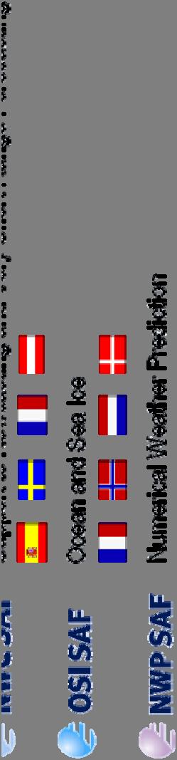


4 The EUMETSAT SAF Network EUMETSAT Member States EUMETSAT Cooperating States 4


5 CM SAF Partners Deutscher Wetterdienst Swedish Meteorological and Hydrological Institute Royal Meteorological Institute of Belgium Finnish Meteorological Institute EUMETSAT Member States EUMETSAT Cooperating States CM SAF Member States Location of Partner NMHSs Met Office, United Kingdom (since 2017) 5


6 Global Energy and Water Cycle Source: Wild et al.,
7 Global Energy and Water Cycle Source: Wild et al.,
8 CM SAF Product Portfolio Long-term time series of Essential Climate Variables (ECVs) of parameters of the energy and water cycle: Global cloud parameters Global precipitation (planned) Global radiation at surface Global water vapor Regional (Europe & Africa) radiation at surface and TOA Regional land fluxes (planned) CM SAF provides TCDRs and ICDRs 8


9 CM SAF Users Others 0% State authorities 8% Research institutes 46% Pi Private companies 12% Meteorological Services 34% 9

 Temporal: hourly-, daily-,")

")
10 CLAAS-2 Variables Cloud properties Liquid and ice water path Resolution Spatial: ( ) Temporal: hourly-, daily-, monthly means, mean monthly diurnal cycle Coverage Spatial: Meteosat disk Temporal: 2004 to 2015 Satellites Meteosat Second Generation (SEVIRI) DOI: /EUM_SAF_CM/CLAAS/V002 10


11 CLARA-A2 Variables Cloud properties Surface albedo Radiation Resolution Spatial: Temporal: daily-, pentad-, monthly mean Coverage Spatial: global Temporal: 1982 to 2015 Satellites NOAA, Metop (AVHRR) DOI: /EUM_SAF_CM/CLARA_AVHRR/V002 11


 DOI:10.")
12 HOAPS Variables Wind, humidity (close to surface) Precipitation, evaporation Latent heat flux Fresh water flux Resolution Spatial: Temporal: 6-hourly-, monthly means Coverage Spatial: global ice free ocean Temporal: 1987 to 2015 Satellites DMSP (SSM/I) DOI: /EUM_SAF_CM/HOAPS/V002 12
 DOI:10.")
13 FCDR SSM/I Variables Brightness temperature Resolution Spatial: native SSM/I Temporal: native SSM/I Coverage Spatial: global Temporal: 1987 to 2008 Satellites DMSP (SSM/I) DOI: /EUM_SAF_CM/FCDR_MWI/V002 13
 Spectral a")
 Resolution Spatial: 0.05 05 005 0.")

 DOI:10.")
14 SARAH-2 Variables Global radiation (SIS) Surface direct irradiance (SDI) Spectral a resolved ed irradiance a (SRI) Effective cloud albedo (CAL) Resolution Spatial: Temporal: 30 min instantaneous, daily-, monthly means Coverage Spatial: Meteosat disk Temporal: 1983 to 2015 Satellites Meteosat 2 to 10 (MVIRI/SEVIRI) DOI: /EUM_SAF_CM/SARAH/V002 14


15 Application Example Sunshine Duration Sunshine duration important parameter Tourism Health Sector Agriculture Vegetation modelling Solar energy DWD satellite-based sunshine duration 15


16 Application Example Sunshine Duration Sunshine duration important parameter Tourism Health Sector Agriculture Vegetation modelling Solar energy First satellite-based sunshine duration dataset for Europe and Africa DWD satellite-based sunshine duration 16


 DWD satellite-based")
17 Application Example Sunshine Duration Sunshine duration important parameter Tourism Health Sector Agriculture Vegetation modelling Solar energy First satellite-based sunshine duration dataset for Europe and Africa Basis SARAH-2 radiation data Preliminary evaluation showed good agreement with station data (<10%) DWD satellite-based sunshine duration 17


 Suitable for many applications DWD")
18 Application Example Sunshine Duration Sunshine duration important parameter Tourism Health Sector Agriculture Vegetation modelling Solar energy First satellite-based sunshine duration dataset for Europe and Africa Basis SARAH-2 radiation data Preliminary evaluation showed good agreement with station data (<10%) Suitable for many applications DWD satellite-based sunshine duration 18

19 Application Example Sunshine Duration 19


20 Application Example Sunny Days Global Climatology of Sunny Days based on SARAH and CLARA Sunny day is defined by mean daily global radiation 80 % of maximum possible solar insolation Sunny period is characterized by five consecutive sunny days Sunny days interactive map on CM SAF webpage 20
21 Application Example Sunny Days 21
22 Application Example Sunny Days 22
23 Application Example Sunny Days 23
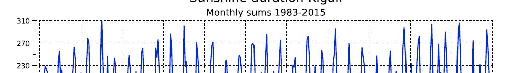
24 Application Example Sunny Days 24
25 Application Example Sunny Days 25
26 Application Example Sunny Days 26


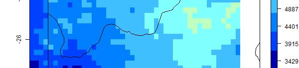
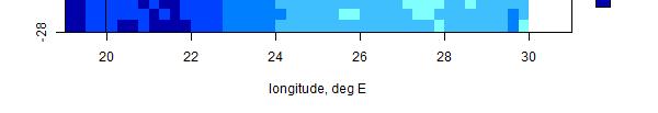
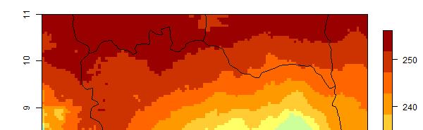
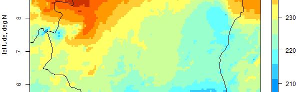
27 Application Example Microphysical Cloud Properties Analysis of cloud optical thickness and effective particle radius offshore Namibia Area known for large stratocumulus fields Data basing on MSG/SEVIRI Investigation area 27
28 Application Example Microphysical Cloud Properties Analysis of cloud optical thickness and effective particle radius offshore Namibia Area known for large stratocumulus fields Data basing on MSG/SEVIRI Typical diurnal cycle was found for cloud optical thickness 17 October 2006 Investigation area and cloud optical thickness 28
29 Application Example Microphysical Cloud Properties Analysis of cloud optical thickness and effective particle radius offshore Namibia Area known for large stratocumulus fields Data basing on MSG/SEVIRI Typical diurnal cycle was found for cloud optical thickness and effective particle radius CM SAF CLAAS data for long-term climatological analysis 17 October 2006 Investigation area and cloud optical thickness 29

 Kindly provided by Lucky")
30 Application Example Solar Atlas South Africa Colleagues from SAWS and JRC produced a solar Atlas for South Africa using CM SAF radiation data Long-term Annual Mean for Global Horizontal Irradiance, period Photovoltaic (PV) energy yield of Global Irradiation on optimally inclined plane for the year (kwh/m2) Kindly provided by Lucky Ntsangwane (SAWS) 30


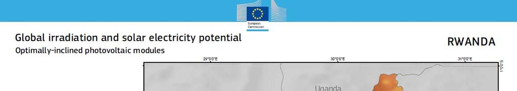
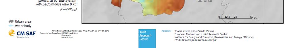
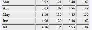
31 Application Example Solar Energy Production forecast, planning, monitoring of solar energy needs radiation data for at least 10 years PVGIS tool of Joint Research Centre Free PV online tool Uses CM SAF solar radiation data Production forecast and potential estimation Easy to apply For all African countries Solar energy potential ti from PVGIS for Rwanda 31


32 Application Example Solar Energy Solar energy potential from PVGIS for Rwanda 32


33 Application Example Solar Energy 33


34 Application Example Solar Energy 34
 Reconstructed natural vegetation cover of")
 Reconstructed Land cover map of Ethiopia (agricultural areas replaced by the")
35 Application Example Agriculture Ethiopia Reconstructing gpre-agricultural expansion vegetation cover of Ethiopia (a) Reconstructed natural vegetation cover of agricultural land. (b) Reconstructed Land cover map of Ethiopia (agricultural areas replaced by the simulated natural vegetation cover). Hailu et al., 2015, Applied Geography 35


36 Data Access Web User Interface Easy selection and online ordering Possibility of regular data delivery Postprocessing: Spatial, temporal Data format (netcdf, hdf) Selection of region Ftp or All data free of charge 36


37 Data Access EUMETCast The following CM SAF products are disseminated via EUMETCast: Monthly mean fractional cloud cover Monthly mean surface incoming shortwave radiation Product format is netcdf. EUMETCast Africa: Channel: SAF-Africa PID: 301 Multicast Address:
38 Toolbox CM SAF provides CM SAF R Toolbox for free cmsaf R-package collection of functions for simply analysis and manipulation of CM SAF netcdf data (see cran.r-project.org) R-scripts for analysis and visualization of CM SAF data R-scripts, which help unexperienced R-users to apply functions of cmsaf R-package 38


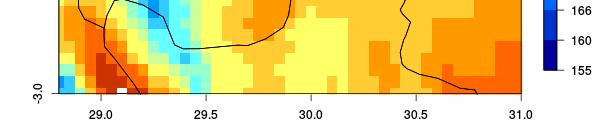
39 Application Example Toolbox Examples by User Forum Participants Unexplained seasonal patterns over Mauritius Large annual variability in Senegal 39


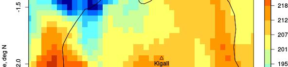

40 Application Example Toolbox Kigali 40


41 Training Training workshops in cooperation with EUMETSAT Practical exercises with CM SAF data For content of previous courses see the community site 41
42 Satellite based assessment of extreme weather e events e and agricultural a production potential in Uganda Barasa Bernard barasagis@cedat.mak.ac.ug g


43 Results Annual mean rainfall Annual mean SIS


44 Results Floods events in September, 2007, April, 2008, September, 2012 and May, 2013
45 Results Drought (February, 1998, 2005, 2010, 2012)
46 By: Tiro Nkemelang


47 - Rainfall in Botswana mainly convective. y - Good correlation between rainfall distribution and cloud top height
48 CM SAF Training Workshop Pretoria (South Africa) 8 12 June 2015 Training Project COULIBALY Kolotioloma Alama from National Meteorological Service of Cote d Ivoire kcoulibaly2@yahoo.fr


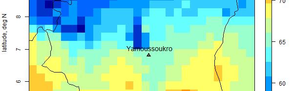
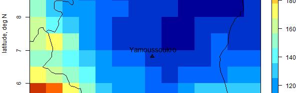

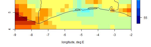


49 Climatology pattern 10 9 Odienné Korhogo 8 Man Bouaké Bondoukou 7 Daloa Yamoussoukro Dimbokro 6 Gagnoa 5 Abidjan Adiaké Sassandra San-Pédro Tabou
50 CM SAF Data Analysis: Burkina Faso Case Study Guillaume NAKOULMA Burkina Faso Meteorological Service


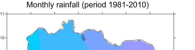
51 Spatial Distribution Climatology SIS CFC PRECIP

52 Summary Products and services in connection with global energy and water cycle Especially geostationary products excellent suitable for Africa Thoroughly quality insurance and control mechanisms Extensive exchange and support with / of users Free and uncomplicated data access So far more about 140 peer-reviewed e e ed publications using CM SAF data Contact data: Steffen.Kothe@dwd.de 52
Satellite-based climate data records. in support to Climate Services. Steffen Kothe and CM SAF Team
 Satellite-based Climate Data Records in support to Climate Services Steffen Kothe and CM SAF Team Satellite-based climate data records in support to Climate Services Steffen Kothe and CM SAF Team Climate
Climate Data Records (CDR) provided by CM SAF. Martin Werscheck Deutscher Wetterdienst
 provided by CM SAF. Martin Werscheck Deutscher Wetterdienst") Climate Data Records (CDR) provided by CM SAF Martin Werscheck Deutscher Wetterdienst CM SAF: EUMETSAT Satellite Application Facility on Climate Monitoring GCOS SCIENCE DAY IMPORTANCE OF THE CLIMATE OBSERVATIONS
Climate Data Records (CDR) provided by CM SAF Martin Werscheck Deutscher Wetterdienst CM SAF: EUMETSAT Satellite Application Facility on Climate Monitoring GCOS SCIENCE DAY IMPORTANCE OF THE CLIMATE OBSERVATIONS
Climate Monitoring from Space: Climate Monitoring
 Climate Monitoring from Space: The EUMETSAT Satellite Application i Facility on Climate Monitoring GCOS Science Conference Amsterdam, The Netherlands, 2 4 March 2016 Martin Werscheck Deutscher Wetterdienst
EUMETSAT SAF NETWORK. Lothar Schüller, EUMETSAT SAF Network Manager
 1 EUMETSAT SAF NETWORK Lothar Schüller, EUMETSAT SAF Network Manager EUMETSAT ground segment overview METEOSAT JASON-2 INITIAL JOINT POLAR SYSTEM METOP NOAA SATELLITES CONTROL AND DATA ACQUISITION FLIGHT
Operational Climate Monitoring
 Operational Climate Monitoring Concept of Climate data records & operational climate monitoring Introduction CM SAF Examples of downstream services in Europe (e.g. WMO RCC RA VI) in US (e.g. drought monitoring)
NWC-SAF Satellite Application Facility in Support to Nowcasting and Very Short Range Forecasting
 NWC-SAF Satellite Application Facility in Support to Nowcasting and Very Short Range Forecasting Marianne König Slide 1 Satellite Application Facilities (SAFs) in Europe Member State Cooperating State
Report. Northern Africa. RAIDEG-8, 1-2 Nov 2017
 Report Northern Africa RAIDEG-8, 1-2 Nov 2017 Report Northern Africa RAIDEG-8, 1-2 Nov 2017 Important Note: Formal letters have been sent from the PR of Morocco with WMO to PRs of Algeria, Tunisia, Libya
EUMETSAT SAF NETWORK. Lothar Schüller, EUMETSAT SAF Network Manager
 1 EUMETSAT SAF NETWORK Lothar Schüller, EUMETSAT SAF Network Manager EUMETSAT ground segment overview METEOSAT JASON-2 INITIAL JOINT POLAR SYSTEM METOP NOAA SATELLITES CONTROL AND DATA ACQUISITION FLIGHT
EUMETSAT Activities Related to Climate
 EUMETSAT Activities Related to Climate Jörg Schulz joerg.schulz@eumetsat.int Slide: 1 What we do USER REQUIREMENTS European National Meteorological Services Operating Agency! European Space Industry Private
MAIN ATTRIBUTES OF THE PRECIPITATION PRODUCTS DEVELOPED BY THE HYDROLOGY SAF PROJECT RESULTS OF THE VALIDATION IN HUNGARY
 MAIN ATTRIBUTES OF THE PRECIPITATION PRODUCTS DEVELOPED BY THE HYDROLOGY SAF PROJECT RESULTS OF THE VALIDATION IN HUNGARY Eszter Lábó OMSZ-Hungarian Meteorological Service, Budapest, Hungary labo.e@met.hu
H SAF SATELLITE APPLICATION FACILITY ON SUPPORT TO OPERATIONAL HYDROLOGY AND WATER MANAGEMENT EUMETSAT NETWORK OF SATELLITE APPLICATION FACILITIES
 H SAF SATELLITE APPLICATION FACILITY ON SUPPORT TO OPERATIONAL HYDROLOGY AND WATER MANAGEMENT EUMETSAT NETWORK OF SATELLITE APPLICATION FACILITIES H-SAF: SATELLITE PRODUCTS FOR OPERATIONAL HYDROLOGY H-SAF
EUMETSAT LSA-SAF EVAPOTRANSPIRATION PRODUCTS STATUS AND PERSPECTIVES
 EUMETSAT LSA-SAF EVAPOTRANSPIRATION PRODUCTS STATUS AND PERSPECTIVES Arboleda, N. Ghilain, F. Gellens-Meulenberghs Royal Meteorological Institute, Avenue Circulaire, 3, B-1180 Bruxelles, BELGIUM Corresponding
TAMSAT: LONG-TERM RAINFALL MONITORING ACROSS AFRICA
 TAMSAT: LONG-TERM RAINFALL MONITORING ACROSS AFRICA Ross Maidment, Emily Black, Matthew Young and Dagmawi Asfaw TAMSAT, University of Reading Helen Greatrex IRI, Columbia University 13 th EUMETSAT User
EUMETSAT s Support to Climate Services and User Support. Joachim Saalmüller
 EUMETSAT s Support to Climate Services and User Support Joachim Saalmüller 1 User Forum in Africa September 2016 Outline of my talk EUMETSAT in support of climate services Exploring our data and subscribing
Evapotranspiration monitoring with Meteosat Second Generation satellites: method, products and utility in drought detection.
 Evapotranspiration monitoring with Meteosat Second Generation satellites: method, products and utility in drought detection. Nicolas Ghilain Royal Meteorological Institute Belgium EUMeTrain Event week
(1) AEMET (Spanish State Meteorological Agency), Demóstenes 4, Málaga, Spain ABSTRACT
 AEMET (Spanish State Meteorological Agency), Demóstenes 4, Málaga, Spain ABSTRACT") COMPARISON OF GROUND BASED GLOBAL RADIATION MEASUREMENTS FROM AEMET RADIATION NETWORK WITH SIS (SURFACE INCOMING SHORTWAVE RADIATION) FROM CLIMATE MONITORING-SAF Juanma Sancho1, M. Carmen Sánchez de Cos1,
COMPARISON OF GROUND BASED GLOBAL RADIATION MEASUREMENTS FROM AEMET RADIATION NETWORK WITH SIS (SURFACE INCOMING SHORTWAVE RADIATION) FROM CLIMATE MONITORING-SAF Juanma Sancho1, M. Carmen Sánchez de Cos1,
LAND SURFACE ALBEDO AND DOWNWELLING SHORTWAVE RADIATION FROM MSG GEOSTATIONARY SATELLITE (METHOD FOR RETRIEVAL, VALIDATION, AND APPLICATION)
") LAND SURFACE ALBEDO AND DOWNWELLING SHORTWAVE RADIATION FROM MSG GEOSTATIONARY SATELLITE (METHOD FOR RETRIEVAL, VALIDATION, AND APPLICATION) Dominique Carrer, Jean-Louis Roujean, Olivier Hautecoeur, Jean-Christophe
LAND SURFACE ALBEDO AND DOWNWELLING SHORTWAVE RADIATION FROM MSG GEOSTATIONARY SATELLITE (METHOD FOR RETRIEVAL, VALIDATION, AND APPLICATION) Dominique Carrer, Jean-Louis Roujean, Olivier Hautecoeur, Jean-Christophe
MONITORING THE ATMOSPHERE, OCEAN AND CLIMATE FROM SPACE
 MONITORING THE ATMOSPHERE, OCEAN AND CLIMATE FROM SPACE TRANSFORMING OUR WORLD MONITORING WEATHER AND CLIMATE FROM SPACE MONITORING THE ATMOSPHERE, OCEAN AND CLIMATE FROM SPACE FOR TRANSFORMING OUR WORLD
Mauritius Meteorological Services
 Mauritius Meteorological Services Capabilities for the provision of climate services at national level Prem Goolaup Deputy Director St Paul Road, Vacoas. Mauritius Tel. +(230)57 86 08 38 Email: prem.goolaup@gmail.com
Surface UV Irradiance from OMI on EOS Aura. Atmospheric Science Conference ESRIN, 8-12 May 2006 Aapo Tanskanen
 Surface UV Irradiance from OMI on EOS Aura Atmospheric Science Conference ESRIN, 8-12 May 2006 Aapo Tanskanen Contents OMI Surface UV Algorithm N. Krotkov /GEST Center, University of Maryland J. Herman
Air sea satellite flux datasets and what they do (and don't) tell us about the air sea interface in the Southern Ocean
 tell us about the air sea interface in the Southern Ocean") Air sea satellite flux datasets and what they do (and don't) tell us about the air sea interface in the Southern Ocean Carol Anne Clayson Woods Hole Oceanographic Institution Southern Ocean Workshop Seattle,
Air sea satellite flux datasets and what they do (and don't) tell us about the air sea interface in the Southern Ocean Carol Anne Clayson Woods Hole Oceanographic Institution Southern Ocean Workshop Seattle,
Speedwell High Resolution WRF Forecasts. Application
 Speedwell High Resolution WRF Forecasts Speedwell weather are providers of high quality weather data and forecasts for many markets. Historically we have provided forecasts which use a statistical bias
H-SAF future developments on Convective Precipitation Retrieval
 H-SAF future developments on Convective Precipitation Retrieval Francesco Zauli 1, Daniele Biron 1, Davide Melfi 1, Antonio Vocino 1, Massimiliano Sist 2, Michele De Rosa 2, Matteo Picchiani 2, De Leonibus
ASSESSMENT OF DIFFERENT WATER STRESS INDICATORS BASED ON EUMETSAT LSA SAF PRODUCTS FOR DROUGHT MONITORING IN EUROPE
 ASSESSMENT OF DIFFERENT WATER STRESS INDICATORS BASED ON EUMETSAT LSA SAF PRODUCTS FOR DROUGHT MONITORING IN EUROPE G. Sepulcre Canto, A. Singleton, J. Vogt European Commission, DG Joint Research Centre,
A HIGH RESOLUTION EUROPEAN CLOUD CLIMATOLOGY FROM 15 YEARS OF NOAA/AVHRR DATA
 A HIGH RESOLUTION EUROPEAN CLOUD CLIMATOLOGY FROM 15 YEARS OF NOAA/AVHRR DATA R. Meerkötter 1, G. Gesell 2, V. Grewe 1, C. König 1, S. Lohmann 1, H. Mannstein 1 Deutsches Zentrum für Luft- und Raumfahrt
EUMETSAT Training activities. Vesa Nietosvaara Mark Higgins
 EUMETSAT Training activities Vesa Nietosvaara Mark Higgins EUMETSAT Partnerships Europe: SAFs and regional networks EUMeTrain training recourses and tools Eumetcal coordination and infrastructure Africa:
Commercialisation. Lessons learned from Dutch weather market
 Commercialisation Lessons learned from Dutch weather market Where information comes together weather traffic public transport Weather, traffic and public transport. Daily actual information that influences
Climate Prediction Center National Centers for Environmental Prediction
 NOAA s Climate Prediction Center Climate Monitoring Tool Wassila M. Thiaw and CPC International Team Climate Prediction Center National Centers for Environmental Prediction CPC International Team Vadlamani
SAWIDRA Southern Africa
 SAWIDRA Southern Africa Presenter: Thembani Moitlhobogi Assistant Database and IT Expert SADC Climate Services Centre 13 th EUMETSAT Forum in Africa 24-28 September 2018, Abidjan, Cote d Ivoire Context
Global solar radiation: comparison of satellite and ground based observations
 Global solar radiation: comparison of satellite and ground based observations Petr Skalak 1,2, Piotr Struzik 3, Aleš Farda 2,1, Pavel Zahradníček 2,1, Petr Štěpánek 2,1 1) Czech Hydrometeorological Institute,
P1.34 MULTISEASONALVALIDATION OF GOES-BASED INSOLATION ESTIMATES. Jason A. Otkin*, Martha C. Anderson*, and John R. Mecikalski #
 P1.34 MULTISEASONALVALIDATION OF GOES-BASED INSOLATION ESTIMATES Jason A. Otkin*, Martha C. Anderson*, and John R. Mecikalski # *Cooperative Institute for Meteorological Satellite Studies, University of
Applications of multi-spectral satellite data
 Applications of multi-spectral satellite data Jochen Kerkmann EUMETSAT, Satellite Meteorologist, Training Officer Adjusted by E de Coning South African Weather Service Content 1. Why should we use RGBs?
EUMETSAT Climate Activities
 EUMETSAT Climate Activities Jörg Schulz EUMETSAT s Role in Climate Monitoring EUMETSAT has a prominent role in the world for providing services relevant to climate: EUMETSAT maintains some of the longest
VALIDATION OF MSG DERIVED SURFACE INCOMING GLOBAL SHORT-WAVE RADIATION PRODUCTS OVER BELGIUM
 VALIDATION OF MSG DERIVED SURFACE INCOMING GLOBAL SHORT-WAVE RADIATION PRODUCTS OVER BELGIUM C. Bertrand 1, R. Stöckli 2, M. Journée 1 1 Royal Meteorological Institute of Belgium (RMIB), Brussels, Belgium
OSI SAF SST Products and Services
 OSI SAF SST Products and Services Pierre Le Borgne Météo-France/DP/CMS (With G. Legendre, A. Marsouin, S. Péré, S. Philippe, H. Roquet) 2 Outline Satellite IR radiometric measurements From Brightness Temperatures
WMO Climate Information Services System
 World Meteorological Organization Working together in weather, climate and water WMO Climate Information Services System Peer Hechler WMO WMO www.wmo.int Aim of talk To elaborate on some relevant global
APPENDIX 2 OVERVIEW OF THE GLOBAL PRECIPITATION MEASUREMENT (GPM) AND THE TROPICAL RAINFALL MEASURING MISSION (TRMM) 2-1
 AND THE TROPICAL RAINFALL MEASURING MISSION (TRMM) 2-1") APPENDIX 2 OVERVIEW OF THE GLOBAL PRECIPITATION MEASUREMENT (GPM) AND THE TROPICAL RAINFALL MEASURING MISSION (TRMM) 2-1 1. Introduction Precipitation is one of most important environmental parameters.
APPENDIX 2 OVERVIEW OF THE GLOBAL PRECIPITATION MEASUREMENT (GPM) AND THE TROPICAL RAINFALL MEASURING MISSION (TRMM) 2-1 1. Introduction Precipitation is one of most important environmental parameters.
Climate Services in Seychelles
 Climate Services in Seychelles Vincent Amelie Seychelles Met. Services Email: v.amelie@meteo.gov.sc Regional Consultation on Climate Services in the Indian Ocean Islands, Ebène, Mauritius, 14-16 March
RAIDEG7 and GFCS needs. Mariane Diop Kane Chair of RAIDEG Director of Meteorology, ANACIM
 RAIDEG7 and GFCS needs Mariane Diop Kane Chair of RAIDEG Director of Meteorology, ANACIM RA-I Dissemination Expert Group (RAIDEG) Established in 2010 by WMO, in cooperation with EUMETSAT Endorsed by WMO
Satellite And Weather Information (SAWIDRA)/RARS
/RARS") Satellite And Weather Information for Disaster Resilience in Africa (SAWIDRA)/RARS Benjamin Lamptey, PhD ACMAD bllamptey@gmail.com EU funding and overall context 1. EUR 80 million Intra ACP Programme Building
Satellite And Weather Information for Disaster Resilience in Africa (SAWIDRA)/RARS Benjamin Lamptey, PhD ACMAD bllamptey@gmail.com EU funding and overall context 1. EUR 80 million Intra ACP Programme Building
THE LAND-SAF SURFACE ALBEDO AND DOWNWELLING SHORTWAVE RADIATION FLUX PRODUCTS
 THE LAND-SAF SURFACE ALBEDO AND DOWNWELLING SHORTWAVE RADIATION FLUX PRODUCTS Bernhard Geiger, Dulce Lajas, Laurent Franchistéguy, Dominique Carrer, Jean-Louis Roujean, Siham Lanjeri, and Catherine Meurey
SuperPack North America
 SuperPack North America Speedwell SuperPack makes available an unprecedented range of quality historical weather data, and weather data feeds for a single annual fee. SuperPack dramatically simplifies
Judit Kerényi. OMSZ-Hungarian Meteorological Service P.O.Box 38, H-1525, Budapest Hungary Abstract
 Comparison of the precipitation products of Hydrology SAF with the Convective Rainfall Rate of Nowcasting-SAF and the Multisensor Precipitation Estimate of EUMETSAT Judit Kerényi OMSZ-Hungarian Meteorological
EUMETSAT. A global operational satellite agency at the heart of Europe. Presentation for the Spanish Industry Day Madrid, 15 March 2012
 EUMETSAT A global operational satellite agency at the heart of Europe Presentation for the Spanish Industry Day Madrid, Angiolo Rolli EUMETSAT Director of Administration EUMETSAT objectives The primary
VALIDATION RESULTS OF THE OPERATIONAL LSA-SAF SNOW COVER MAPPING
 VALIDATION RESULTS OF THE OPERATIONAL LSA-SAF SNOW COVER MAPPING Niilo Siljamo, Otto Hyvärinen Finnish Meteorological Institute, Erik Palménin aukio 1, P.O.Box 503, FI-00101 HELSINKI Abstract Hydrological
Creating a WeatherSMART nation: SAWS drought related research, services and products
 Creating a WeatherSMART nation: SAWS drought related research, services and products Drought Dialogue 23-24 June 2016 Western Cape Government Hannes Rautenbach South African Weather Service SAWS mandate
REPORT ON EUMETCAST INCLUDING GEONETCAST
 Prepared by EUMETSAT Agenda Item: F.2 Discussed in Plenary REPORT ON EUMETCAST INCLUDING GEONETCAST This paper presents the actual status of the system architecture, data services supported, and registration
1 Introduction. Station Type No. Synoptic/GTS 17 Principal 172 Ordinary 546 Precipitation
 Use of Automatic Weather Stations in Ethiopia Dula Shanko National Meteorological Agency(NMA), Addis Ababa, Ethiopia Phone: +251116639662, Mob +251911208024 Fax +251116625292, Email: Du_shanko@yahoo.com
CGMS-45-WMO-WP-05 Monitoring Extreme Weather and Climate from Space. World Meteorological Organization (WMO) Space Programme
 Space Programme") CGMS-45-WMO-WP-05 Monitoring Extreme Weather and Climate from Space World Meteorological Organization (WMO) Space Programme Introduction UNOSAT Report Satellite Detected Waters over Xieng Ngneun District,
CGMS-45-WMO-WP-05 Monitoring Extreme Weather and Climate from Space World Meteorological Organization (WMO) Space Programme Introduction UNOSAT Report Satellite Detected Waters over Xieng Ngneun District,
Pilot applications for Egypt related end-users
 GEO-CRADLE Regional Workshop Thursday, 25 th May, 2017 Pilot applications for Egypt related end-users Hesham El-Askary Chapman University Panagiotis Kosmopoulos National Observatory of Athens Stelios Kazadzis
Comparison of MSG-SEVIRI and SPOT-VEGETATION data for vegetation monitoring over Africa
 Comparison of MSG-SEVIRI and SPOT-VEGETATION data for vegetation monitoring over Africa Bernard LACAZE CNRS UMR 8586 PRODIG Pôle Image et Campus Spatial, Université Paris Diderot Paris 7 Objectives Comparison
The PRECIS Regional Climate Model
 The PRECIS Regional Climate Model General overview (1) The regional climate model (RCM) within PRECIS is a model of the atmosphere and land surface, of limited area and high resolution and locatable over
Regional offline land surface simulations over eastern Canada using CLASS. Diana Verseghy Climate Research Division Environment Canada
 Regional offline land surface simulations over eastern Canada using CLASS Diana Verseghy Climate Research Division Environment Canada The Canadian Land Surface Scheme (CLASS) Originally developed for the
Characterization of the solar irradiation field for the Trentino region in the Alps
 Characterization of the solar irradiation field for the Trentino region in the Alps L. Laiti*, L. Giovannini and D. Zardi Atmospheric Physics Group University of Trento - Italy outline of the talk Introduction
INCA-CE achievements and status
 INCA-CE achievements and status Franziska Strauss Yong Wang Alexander Kann Benedikt Bica Ingo Meirold-Mautner INCA Central Europe Integrated nowcasting for the Central European area This project is implemented
EUMETSAT EXPERIENCES IN RESPONDING TO THE REQUIREMENTS OF OPERATIONAL USERS
 EUMETSAT EXPERIENCES IN RESPONDING TO THE REQUIREMENTS OF OPERATIONAL USERS Outlook What is EUMETSAT How does EUMETSAT work Building capacity for a better utilisation of satellite data Example working
Deutscher Wetterdienst. German Climate Services - A contribution to the Global Framework for Climate Services (GFCS) Tobias Fuchs and Paul Becker
 Tobias Fuchs and Paul Becker") Deutscher Wetterdienst German Climate Services - A contribution to the Global Framework for Climate Services (GFCS) Tobias Fuchs and Paul Becker Deutscher Wetterdienst (DWD) Business Area Climate and Environment
Deutscher Wetterdienst German Climate Services - A contribution to the Global Framework for Climate Services (GFCS) Tobias Fuchs and Paul Becker Deutscher Wetterdienst (DWD) Business Area Climate and Environment
Regional Consultation on Climate Services at the National Level for South East Europe Antalya, Turkey November
 malsale@meteo.gov.vu Regional Consultation on Climate Services at the National Level for South East Europe Antalya, Turkey 21-22 November 2014 n.rudan@rhmzrs.com Capacities for the management of climatic
SNOW COVER MAPPING USING METOP/AVHRR DATA
 SNOW COVER MAPPING USING METOP/AVHRR DATA Niilo Siljamo, Markku Suomalainen, Otto Hyvärinen Finnish Meteorological Institute, Erik Palménin Aukio 1, FI-00101 Helsinki, Finland Abstract LSA SAF snow cover
Weather Satellite Data Applications for Monitoring and Warning Hazard at BMKG
 The 5th Meeting of the Coordinating Group of the RA II WIGOS Satellite Project 21 October 2017, Vladivostok city, Russky Island, Russia Far Eastern Federal University Weather Satellite Data Applications
McIDAS support of Suomi-NPP /JPSS and GOES-R L2
 McIDAS support of Suomi-NPP /JPSS and GOES-R L2 William Straka III 1 Tommy Jasmin 1, Bob Carp 1 1 Cooperative Institute for Meteorological Satellite Studies, Space Science and Engineering Center, University
The Delaware Environmental Monitoring & Analysis Center
 The Delaware Environmental Monitoring & Analysis Center Tina Callahan Delaware Estuary Science & Environmental Summit 2013 January 27-30, 2013 What is DEMAC? Delaware Environmental Monitoring & Analysis
Extratropical and Polar Cloud Systems
 Extratropical and Polar Cloud Systems Gunilla Svensson Department of Meteorology & Bolin Centre for Climate Research George Tselioudis Extratropical and Polar Cloud Systems Lecture 1 Extratropical cyclones
5. General Circulation Models
 5. General Circulation Models I. 3-D Climate Models (General Circulation Models) To include the full three-dimensional aspect of climate, including the calculation of the dynamical transports, requires
ERA-CLIM: Developing reanalyses of the coupled climate system
 ERA-CLIM: Developing reanalyses of the coupled climate system Dick Dee Acknowledgements: Reanalysis team and many others at ECMWF, ERA-CLIM project partners at Met Office, Météo France, EUMETSAT, Un. Bern,
Satellite-Based Sunshine Duration for Europe
 Remote Sens. 2013, 5, 2943-2972; doi:10.3390/rs5062943 Article OPEN ACCESS Remote Sensing ISSN 2072-4292 www.mdpi.com/journal/remotesensing Satellite-Based Sunshine Duration for Europe Steffen Kothe 1,
OSI SAF Sea Ice products
 OSI SAF Sea Ice products Lars-Anders Brevik, Gorm Dybkjær, Steinar Eastwood, Øystein Godøy, Mari Anne Killie, Thomas Lavergne, Rasmus Tonboe, Signe Aaboe Norwegian Meteorological Institute Danish Meteorological
The skill of ECMWF cloudiness forecasts
 from Newsletter Number 143 Spring 215 METEOROLOGY The skill of ECMWF cloudiness forecasts tounka25/istock/thinkstock doi:1.21957/lee5bz2g This article appeared in the Meteorology section of ECMWF Newsletter
Use of satellite information in research and operational activities at NIMH of Bulgaria
 Use of satellite information in research and operational activities at NIMH of Bulgaria Rilka Valcheva NIMH, Bulgaria WMO/EUMETSAT Satellite Products Training Course 24-28 April 2017, Budapest, Hungary
Satellite Application Facility on Ocean and Sea Ice (OSI SAF) Cécile Hernandez Plouzané, 20 June 2017
 Cécile Hernandez Plouzané, 20 June 2017") Satellite Application Facility on Ocean and Sea Ice (OSI SAF) Cécile Hernandez Plouzané, 20 June 2017 About OSI SAF EUMETSAT SAFs : dedicated centres of excellence for processing satellite data OSI SAF
Satellite Application Facility on Ocean and Sea Ice (OSI SAF) Cécile Hernandez Plouzané, 20 June 2017 About OSI SAF EUMETSAT SAFs : dedicated centres of excellence for processing satellite data OSI SAF
Using the EartH2Observe data portal to analyse drought indicators. Lesson 4: Using Python Notebook to access and process data
 Using the EartH2Observe data portal to analyse drought indicators Lesson 4: Using Python Notebook to access and process data Preface In this fourth lesson you will again work with the Water Cycle Integrator
13 th EUMETSAT User Forum in Africa
 13 th EUMETSAT User Forum in Africa GMES & Africa implementation in Western Africa Dogbeda M.Y. Azumah Regional Marine Centre University of Ghana Pictures zone UG GMES Presentation Layout UG G Project
Global Solar Dataset for PV Prospecting. Gwendalyn Bender Vaisala, Solar Offering Manager for 3TIER Assessment Services
 Global Solar Dataset for PV Prospecting Gwendalyn Bender Vaisala, Solar Offering Manager for 3TIER Assessment Services Vaisala is Your Weather Expert! We have been helping industries manage the impact
Global Challenges - Partnering with Service Providers. World Meteorological Organization. J. Lengoasa WMO Deputy Secretary-General
 WMO World Meteorological Organization Working together in weather, climate and water Global Challenges - Partnering with Service Providers J. Lengoasa WMO Deputy Secretary-General jlengoasa@wmo.int http://www.wmo.int/pages/gfcs/gfcs_en.html
Operational Uses of Bands on the GOES-R Advanced Baseline Imager (ABI) Presented by: Kaba Bah
 Presented by: Kaba Bah") Operational Uses of Bands on the GOES-R Advanced Baseline Imager (ABI) Presented by: Kaba Bah Topics: Introduction to GOES-R & ABI ABI individual bands Use of band differences ABI derived products Conclusions
Operational Uses of Bands on the GOES-R Advanced Baseline Imager (ABI) Presented by: Kaba Bah Topics: Introduction to GOES-R & ABI ABI individual bands Use of band differences ABI derived products Conclusions
Land Surface Temperature in the EUMETSAT LSA SAF: Current Service and Perspectives. Isabel Trigo
 Land Surface Temperature in the EUMETSAT LSA SAF: Current Service and Perspectives Isabel Trigo Outline EUMETSAT Land-SAF: Land Surface Temperature Geostationary Service SEVIRI Polar-Orbiter AVHRR/Metop
By Lillian Ntshwarisang Department of Meteorological Services Phone:
 By Lillian Ntshwarisang Department of Meteorological Services Phone: +267 3612200 Email: lntshwarisang@gov.bw/ lntshwarisang@gmail.com Introduction Mandate of DMS Function of the Department Services to
International Desks: African Training Desk and Projects
 The Climate Prediction Center International Desks: African Training Desk and Projects Wassila M. Thiaw Team Leader Climate Prediction Center National Centers for Environmental Predictions 1 African Desk
QualiMET 2.0. The new Quality Control System of Deutscher Wetterdienst
 QualiMET 2.0 The new Quality Control System of Deutscher Wetterdienst Reinhard Spengler Deutscher Wetterdienst Department Observing Networks and Data Quality Assurance of Meteorological Data Michendorfer
VWG.01 EUMETSAT Corporate Slide Collection (EUM/CIS/VWG/14/743878) Version 1, January 2014 MONITORING WEATHER AND CLIMATE FROM SPACE
 Version 1, January 2014 MONITORING WEATHER AND CLIMATE FROM SPACE") 1 VWG.01 EUMETSAT Corporate Slide Collection (EUM/CIS/VWG/14/743878) Version 1, January 2014 MONITORING WEATHER AND CLIMATE FROM SPACE Royal charter: 25/26 October 1859 From observation to decision making:
1 VWG.01 EUMETSAT Corporate Slide Collection (EUM/CIS/VWG/14/743878) Version 1, January 2014 MONITORING WEATHER AND CLIMATE FROM SPACE Royal charter: 25/26 October 1859 From observation to decision making:
National Weather Service Flood Forecast Needs: Improved Rainfall Estimates
 National Weather Service Flood Forecast Needs: Improved Rainfall Estimates Weather Forecast Offices Cleveland and Northern Indiana Ohio River Forecast Center Presenter: Sarah Jamison, Service Hydrologist
Space-based Weather and Climate Extremes Monitoring (SWCEM) Toshiyuki Kurino WMO Space Programme IPET-SUP-3, 2-4 May 2017
 Toshiyuki Kurino WMO Space Programme IPET-SUP-3, 2-4 May 2017") Space-based Weather and Climate Extremes Monitoring (SWCEM) Toshiyuki Kurino WMO Space Programme IPET-SUP-3, 2-4 May 2017 based on outcome from Workshop on Operational SWCEM 15-17 February 2017, Geneva
Space-based Weather and Climate Extremes Monitoring (SWCEM) Toshiyuki Kurino WMO Space Programme IPET-SUP-3, 2-4 May 2017 based on outcome from Workshop on Operational SWCEM 15-17 February 2017, Geneva
ERA-CLIM2-WP3: Satellite data reprocessing and inter-calibration
 ERA-CLIM2-WP3: Satellite data reprocessing and inter-calibration Rob Roebeling, Jörg Schulz, Marie Doutriaux- Boucher, Alessio Lattanzio, Viju John, and Andrey Bogdanov Thanks to: Christian Marquardt and
Status report on current and future satellite systems by EUMETSAT Presented to CGMS-44, Plenary session, agenda item D.1
 Status report on current and future satellite systems by EUMETSAT Presented to CGMS-44, Plenary session, agenda item D.1 CGMS-44-EUMETSAT-WP-19.ppt, version 1 (# 859110), 8 June 2016 MISSION PLANNING YEAR...
The National Meteorological Services Agency Satellite Data reception and processing unit First phase by Yitaktu Tesfatsion
 The National Meteorological Services Agency Satellite Data reception and processing unit First phase by Yitaktu Tesfatsion In Ethiopia the rain guage network is not evenly distributed over the country.
Global Precipitation Data Sets
 Global Precipitation Data Sets Rick Lawford (with thanks to Phil Arkin, Scott Curtis, Kit Szeto, Ron Stewart, etc) April 30, 2009 Toronto Roles of global precipitation products in drought studies: 1.Understanding
Flood mapping for index-based disaster risk transfer and insurance mechanisms
 Flood mapping for index-based disaster risk transfer and insurance mechanisms Atmospheric and Environmental Research (AER) African Risk Capacity (ARC) Contributors: AER: John Galantowicz, Jeff Picton,
eport Nataša Strelec Mahović Meteorological and Hydrological Service, Grič 3, Zagreb, Croatia EUMeTrain project Abstract
 eport Nataša Strelec Mahović Meteorological and Hydrological Service, Grič 3, Zagreb, Croatia EUMeTrain project Abstract The paper presents the concept of eport, an interface enabling the combined analysis
Weather Climate Science to Service Partnership South Africa
 PROJECTS UNDERWAY Title of the Weather Climate Science to Service Partnership South Africa Together, building on an existing strong partnership, South African Weather Service and the Met Office will build
VALIDATION OF THE OSI SAF RADIATIVE FLUXES
 VALIDATION OF THE OSI SAF RADIATIVE FLUXES Pierre Le Borgne, Gérard Legendre, Anne Marsouin Météo-France/DP/Centre de Météorologie Spatiale BP 50747, 22307 Lannion, France Abstract The Ocean and Sea Ice
ERA5 and the use of ERA data
 ERA5 and the use of ERA data Hans Hersbach, and many colleagues European Centre for Medium-Range Weather Forecasts Overview Overview of Reanalysis products at ECMWF ERA5, the follow up of ERA-Interim,
Judit Kerényi. OMSZ - Hungarian Meteorological Service, Budapest, Hungary. H-1525 Budapest, P.O.Box 38, Hungary.
 SATELLITE-DERIVED PRECIPITATION ESTIMATIONS DEVELOPED BY THE HYDROLOGY SAF PROJECT CASE STUDIES FOR THE INVESTIGATION OF THEIR ACCURACY AND FEATURES IN HUNGARY Judit Kerényi OMSZ - Hungarian Meteorological
COMBINING EUMETSAT AND SENTINEL MISSIONS TO CREATE NEW OPPORTUNITIES MONITORING WEATHER AND CLIMATE FROM SPACE
 COPERNICUS @EUMETSAT COMBINING EUMETSAT AND SENTINEL MISSIONS TO CREATE NEW OPPORTUNITIES MONITORING WEATHER AND CLIMATE FROM SPACE COPERNICUS A EUROPEAN RESPONSE TO THE CHALLENGE OF GLOBAL MONITORING
Data Set Description. CM SAF Top of Atmosphere Radiation GERB Data Set
 EUMETSAT Satellite Application Facility on Climate Monitoring Data Set Description DOI: 10.5676/EUM_SAF_CM/TOA_GERB/V001 Reference Number: DataSet/Desc/CMSAF/TOA/GERB Issue/Revision Index: 1.0 1. Intent
Regional climate modelling in the future. Ralf Döscher, SMHI, Sweden
 Regional climate modelling in the future Ralf Döscher, SMHI, Sweden The chain Global H E H E C ( m 3/s ) Regional downscaling 120 adam 3 C HAM 4 adam 3 C HAM 4 trl A2 A2 B2 B2 80 40 0 J F M A M J J A S
Amita Mehta and Ana Prados
 Building Capacity in Utilizing NASA Remote Sensing Observations in SWAT for Water Resources and Agricultural Management Applications Amita Mehta and Ana Prados NASA - University of Maryland Baltimore County
Global Instability Index: Product Guide
 Doc.No. Issue : : EUM/TSS/MAN/15/802106 v1c e-signed EUMETSAT Eumetsat-Allee 1, D-64295 Darmstadt, Germany Tel: +49 6151 807-7 Fax: +49 6151 807 555 Date : 2 September 2015 http://www.eumetsat.int WBS/DBS
IGAD Climate Prediction and Applications Centre Monthly Bulletin, August 2014
 IGAD Climate Prediction and Applications Centre Monthly Bulletin, 1. HIGHLIGHTS/ ACTUALITES Rainfall activities were mainly observed over the central parts of the northern sector and western parts of equatorial
Sunshine duration climate maps of Belgium and Luxembourg based on Meteosat and in-situ observations
 Open Sciences doi:1.5194/asr-1-15-213 Author(s) 213. CC Attribution 3. License. Advances in Science & Research Open Access Proceedings Drinking Water Engineering and Science Sunshine duration climate maps
The use of Direct Broadcast Processing System in Poland
 The use of Direct Broadcast Processing System in Poland B.Łapeta, P.Struzik Satellite Remote Sensing Department, Institute of Meteortology and Water Management National Reasearch Institute About IMWM-NRI