MEMO Why megacities? Capability of high-resolution monitoring and forecasting. Comprehensive observation network
|
|
|
- Edward Davis
- 5 years ago
- Views:
Transcription

1


2 MEMO Why megacities? Capability of high-resolution monitoring and forecasting short-time forecasting, nowcasting precise time and area of torrential rain, hail, heavy snow Application of new datasets to numerical model Precise weather services fog and haze, urban citizen health thunder and lightening, severe convective weather Challenges: Capability of vertical observation 4-D real-time observation data cannot be assimilated by numerical model Constraints on forecasting precision, difficultly in the verification of weather prediction Advantages: Comprehensive observation network Regular surface, radiosound, radar, satellite, meteorological observations atmospheric composition detections Capability of urban weather prediction Reanalysis, assimilation and modeling Ability to implement experiment on Observation-Assimilation-Prediction Experience of specialized urban meteorological services CMA gave refined meteorological services to Beijing Olympic 2008, Shanghai EXPO 2010
3 Outline A Brief Introduction of MEMO Scientific and Operational Objectives MEMO Design Scheme Introduction of Experiment A Introduction of Experiment B Expected Achievements
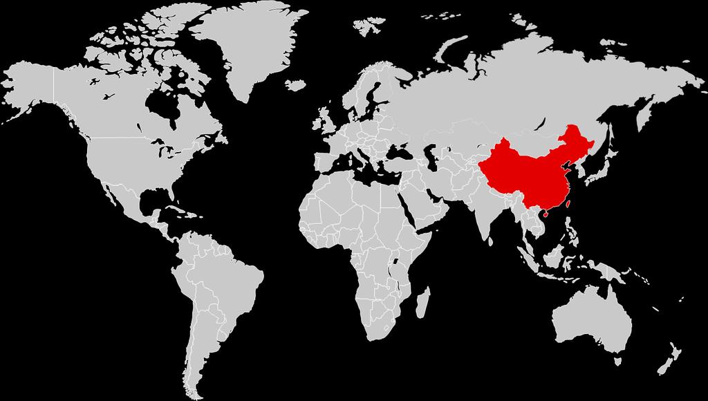
, Shanghai, Guangzhou, Chengdu, Shenyang, Xi'an and Shenzhen.")
4 MEMO A brief Introduction MEMO is initiated by China Meteorological Administration (CMA) and organized by CMA Meteorological Observation Centre (MOC). The experiment takes place in Beijing ( and also the Jing-Jin-Ji region), Shanghai, Guangzhou, Chengdu, Shenyang, Xi'an and Shenzhen. Over a period of three years (2016~2018) of the trial, it will effectively improve the overall quality of meteorological observation data and model assimilation rate, and establish the interaction mechanism of observation and forecast, solve the key technical problems in the short term forecasting, nowcasting and the environment weather service as well. MOC: systematic design, technical support XiAn Chengdu Beijing ShenYang Shanghai Guangzhou Shenzhen and coordinate Achieve the observation modernization in 7 megacities Improve quality of meteorological observation data and assimilation rate Invite professional companies to provide high-tech instruments, test-run and compete the performance of new equipments in MEMO Invite universities and research institutes to participate, jointly work on research and data sharing All technical departments are, great cooperation and collaboration lead to technological innovation


5 MEMO Scientific and Operational Objectives Reveal the characteristic of atmosphere structure in megacities: put emphasis on vertical and horizontal distribution structure, to build seasonal conceptual model of structure of urban heat island and pollutants in fog/haze events Promote the advanced application of comprehensive urban observation data in numerical model: to build operational assimilation system of synthetical meteorological observation data, and improve the prediction ability. Improve the combination of integrated urban observation and nowcasting: to build real-time operational system from observation to nowcasting Comprehensive operational observation system: to build complete set of work flow, specifications and standards Scientific and reasonable Integrated Meteorological Observation Network: able to implement observation on study of characteristics in megacities


6 MEMO Design Scheme Layout optimization Observation System Experiments (OSEs) Observation System Simulation Experiments (OSSEs) Forecast Sensitivity to Observation (FSO) Satellite data Raman-Mie lidar Networked radar Dual Polarization radar Microwave radiometer Wind profiler Millimeter-wave cloud radar Aerosol Humidity Temperature Hydrometeor Wind vector real-time atmosphere 3-D objective analysis fields Time resolution 1 hour Spatial resolution 1-3 km The experiment is decomposed into two sub-experiments A and B to make the implementation more specific: Experiment A on coordination of observation and forecast Based on the experiment, the integrated observation of new observing technologies and equipments would promote the collaboration of observation and forecast, improve the quality of integrated ground-based remote sensing observation and make important contribution to the local numerical forecast Experiment B on vertical observation of fog and haze Realize the vertical detection of aerosols under the boundary layer. Promote the synergy between the observation and the fog/haze forecast, and improve the level of the fog/haze forecast.


")
 Yanqing miyun Flux tower(o) Huailai Changping Shahe")
 IAP Doppler laser Lidar(I) 通州")
 X band Radar(O) Wuqing Ceilometer(O) GCH")

7 Carry out the observation of boundary layer height, vertical profile of wind vector, temperature, hydrometeor and atmospheric composition, utilizing the new technology equipments of wind profile radar, ceilometer, microwave radiometer and aerosol laser lidar. Observation Network Aircraft Mobile laser lidar Wind Profiler(S) 四道穴汤河口 SDZ Microwave Radiometer (O) Wind Profile(R) Wind Profile(I) Yanqing miyun Flux tower(o) Huailai Changping Shahe Huairou Shunyi Pinggu Flux tower(i) Microwave Radiometer (O) Aerosol laser Lidar(I) IAP Doppler laser Lidar(I) 通州 Radiosonde(O) XYL fengtai Nanjiao Baodi GPS Sonde (IOP) Fangshan S/C band Radar(O) X band Radar(O) Wuqing Ceilometer(O) GCH Xiqing Tianjin Tanggu Jinghai S: Data share O: Operational R: Rent I: belong to IUM Chendu Xian Beijin g Shenyang Shanghai X-band Dualpol CINRA D/SA Plan Plan Unde r Cons tructi on WSR- 88D Guangzhou (Shenzhen) Plan Finis hed

8 MEMO Introduction of Experiment A Feedback mechanism of observation and forecast Objective: To promote the collaboration of observation and forecast, establish the high-resolution delicate 3-D objective analysis fields over the metropolis and fulfill the modernization of comprehensive observation in megacities. To improve the quality of integrated ground-based remote sensing observation and make important contribution to the local numerical forecast. To provide technical support to fine-grid forecast in cities, meteorological services for air pollution, drainage, waterlogging prevention, traffic and tourism.
9 资源图示 Experiment A: Intercomparison of fine prediction products and realtime observation, evaluation and verification of numerical model output with groundbased remote sensing measurements Observation network layout optimization test Evaluation and experiment on output of forecast model The assessment of existing observation network and optimization suggestions, including OSEs,OSSEs and FSO Generation technique and experiment on 3D real-time analysis field Experiment on coordination of observation and forecast Sub-experiment design To establish the high-resolution delicate 3-D digital atmosphere over the metropolis; assimilation of new type observation data New equipment, new technology operation observation experiment 单击此处单击此处添加文字添加文字 Satellite observation application experiment Experiment on improving observation operation To establish the comprehensive data application platform of FY, GF and foreign satellites To apply the achievements in operation, data sharing platform of SEMO


10 Experiment A: Technical problems we focus on: 1. Solve the key techniques to improve the data quality of ground-based remote sensing, accomplish the intercomparison and internal verification of fusion data. Through the joint efforts between observation and forecast, the improvement of numerical assimilation of comprehensive vertical profile observation of atmosphere is expected, the digitalized and high-resolution atmosphere can be established based on data fusion technique of multiple ground-based remote sensing observation methods and platforms. Lidar Wind profiler Microwave radiometer Phased-array Radar Dual Polarization radar Millimeter-wave cloud radar 5 key elements of vertical profiles : wind vector, temperature, humidity, hydrometeor and aerosol 6 kinds of observation instruments : Millimeter-wave cloud radar, Microwave radiometer, Wind profiler, Raman-Mie lidar, Phased-array radar, Dual Polarization radar
11 Experiment A: Technical problems we focus on: 2. Expand the observation in megacities from 1-dimentional to multi-dimentional and optimize the comprehensive and vertical observation layout: Establish the top-level design and technical platform of meteorological observation system Implement vertical observation simulation experiment including profiles of wind, temperature and hydrometeor Achieve the observation network layout optimization in megacities by means of Observation system experiment(oses), Observation system simulation experiment(osses) and Forecast Sensitivity to Observation (FSO). Simulation system (nature run) Observation data Assimilation and numerical forecast system Verification Layout design


12 Experiment A: Technical problems we focus on: 3. Key Technologies of Ground Remote Sensing Improvement of Ka cloud radar Improve the detection capability of low clouds Eliminate clear-sky echo effects Improve the ability of recognition of cloud base in precipitation Establish quality control method before after Increase the signal-to-noise ratio and improve the detection capability of low clouds by increasing the transmission power and optimization of antenna structure, Eliminate the influence of clear-sky echo to millimeter wave cloud radar by developing clear-sky echo recognition algorithm and real-time software.


13 Experiment A: 4. Microwave radiometer Technical problems we focus on: 通道 通道 通道 通道 通道 通道 通道 通道 Equipment improvement of microwave radiometer Improved brightness temperature forward model parameter scheme Improvement of temperature and humidity profile retrieval algorithm under the condition of cloud Evaluation method of temperature and humidity profile Establish quality control process 通道 通道 通道 14 通道 通道 不考虑液态水考虑液态水考虑单层液态水 通道 Improved results of forward model of brightness temperature The deviation between the measured brightness temperature and the simulated brightness temperature is obviously decreased after the improvement of the forward model.


14 Experiment A: 5. Wind profiler Technical problems we focus on: Improve the wind observation in precipitation Optimization of quality control Application and verification of propulsion model Technical method In precipitation, the wind profiler radar can detect the atmospheric turbulence echo and the raindrop scattering echo signal, which will bring error to the subsequent atmospheric wind field inversion Technical method Determine the average noise power of wind profiler radar and cloud radar, and then the two are shifted to the same benchmark, subtracted result is the turbulence spectrum.


15 Experiment A: Technical problems we focus on: 6. Strengthen the verification of satellite products with ground-based observation, establish the satellite products verification operation system to improve the satellite data quality operation level. Comprehensive data application Ground-based observation Coordination of space/ground observation Data fusion of space/ground observation Validation of satellite/ground observation High resolution satellite image of Super Typhoon Nepartak on July 7 th

16 MEMO Introduction of Experiment B Feedback mechanism of observation and forecast B3. Comprehensive analysis of in situ and vertical observation of aerosol in fog/haze events Carry out vertical observation of aerosol under PBL, get knowledge of vertical distribution characteristic of aerosol in fog/haze and boundary layer height, build the 3-D objective analysis fields of aerosol PM, enhance the coordination of observation and forecast of fog/haze and improve the local fog/haze forecast ability.
17 资源图示 Experiment B: Sub-experiment design Syhthetical analysis of vertical profile data of multiple observation methods; study on structure of urban aerosol and variation characteristic of PBL ; research on formation and development of haze and fog events in megacities; study on interaction mechanism of PBL and aerosol pollution Improvement of prediction and assessment of chemical weather forecast result Generation technique of 3-D objective analysis fields of aerosol PM under PBL 单击此处添加文字 Carry out observtion and intercomparison of Raman-Mie laser lidar, hyperspectral lidar, unmanned aerial vehicles, MAX-DOAS, sun photometor etc. Operational observation of newly developed technology Comprehensive analysis of in situ and vertical observation of aerosol in haze and fog events Experiment on vertical observation of fog And haze 单击此处添加文字 Layout of haze and fog observation operation
, micropulse laser lidar (3), MAX-DOAS")

18 Experiment B: 1. Vertical profile observation of aerosol in megacities Technical problems we focus on: Vertical observation network in Beijing: Raman-Mie laser lidar (5~7 units), micropulse laser lidar (3), MAX-DOAS (1~2) Observation layout: According to the air pollutants transportation channel in Beijing, Raman-Mie laser lidar will be located along the channel from south-west to north-east and also its perpendicular path, aiming to get vertical distribution and variation characteristic along these two paths. Wind profile radar(wpr); micro-pulse lidar (MPL); microwave radiometer (MWR); Aerosol compositions and size(ams+ SMPS); Reactive Gases; Meteorology; radiation WPR,MPL; Aerosol compositions; Meteorology; radiation; Shijiazhuang MPL; Meteorology; Tower observation Haidian Baoding Double check is needed WPR,MPL; Aerosol composition Gas pollutants; Meteorology. IAP Daxing SDZ WPR,MPL; Aerosol composition Gas pollutants; Meteorology. Xianghe WPR,MPL; Aerosol composition and size(ams+ SMPS); Gas pollutants; Meteorology; radiation; Tower observation WPR,MPL,MWR; Aerosol composition and size; Gas pollutants; Meteorology; radiation; Tower observation Distribution plan of Raman-Mie laser lidar Observation stations in and around Beijing
19 Experiment B: Technical problems we focus on: 2. Operational experiment of Raman-Mie laser lidar: Establish the quantitative and operational vertical observation technique of haze and fog Set up quality control system and operational work flow of Raman-Mie laser lidar Tower 1.Raman-Mie laser lidar calibration test compared with sun photometer 2.Raman-Mie laser lidar calibration test compared with visibility meter 4. Intercomparison Verification of laser lidar with unmanned aerial vehicles 200m 100m Tower Extinction/ Visibility observation Inversion algorithm based on ground visibility observation Extinction/ Visibility observation Extinction/ Visibility observation Raman- Mie laser lidar 5. Data analysis and product development Data analysis, transmission/distribution, quality control product design and development 3. Intercomparison of Raman-Mie laser lidar and hyperspectral lidar Intercomparison sun photometer Hyperspectral lidar Numerical model application
20 MEMO Expected Achievements Several Observing findings : Vertical characteristics of atmospheric boundary layer 5 profiles : wind vector, temperature, humidity, hydrometeor and aerosol Urban heat island effect Operational generation system of realtime atmosphere 3-D objective analysis fields + After the assimilation of newly produced and improved data, make important contribution to forecast result of numerical models Technical standards, specifications and processes of cooperative observation


21 Application of new technology on MEMO Focus on continuous observation of multiple weather conditions, including clear sky, precipitation and fog/haze events Focus Temporal-spatial synchronized observation of multiple elements and parameters of atmosphere Observation of accurate vertical profiles of 5 key elements: temperature, humidity, wind vector, hydrometeor and aerosol Satellite verification Aims Propose to establish the verification and calibration system of operational satellite and ground-based remote sensing technology in megacities, laying foundations of remote sensing application Integrated observation Establish the super integrated observation stations, consisting of Millimeter-wave cloud radar, Microwave radiometer, tropospheric wind profiler, Raman-Mie laser lidar and weather lidar.


22
SURF Progresses Contents
 SURF Progresses Contents 1 5th Workshop: June 21-23, 2017 2 SURF-2016 Summer Experiment 3 Preliminary results 4 Future plan (1) 5 th Workshop: June 21-23, 2017 SURF WS-5: Structure I. New Science Reports
Emerging Needs, Challenges and Response Strategy
 Emerging Needs, Challenges and Response Strategy Development of Integrated Observing Systems in China JIAO Meiyan Deputy Administrator China Meteorological Administration September 2011 Geneva Outline
Progress on GCOS-China CMA IOS Development Plan ( ) PEI, Chong Department of Integrated Observation of CMA 09/25/2017 Hangzhou, China
 PEI, Chong Department of Integrated Observation of CMA 09/25/2017 Hangzhou, China") Progress on GCOS-China CMA IOS Development Plan (2016-2020) PEI, Chong Department of Integrated Observation of CMA 09/25/2017 Hangzhou, China 1. Progress on GCOS-China 1 Organized GCOS-China GCOS-China
Progress on GCOS-China CMA IOS Development Plan (2016-2020) PEI, Chong Department of Integrated Observation of CMA 09/25/2017 Hangzhou, China 1. Progress on GCOS-China 1 Organized GCOS-China GCOS-China
Progress and Plan of China Xilinhot GRUAN works. Zhao Peitao Meteorological Observation Center (MOC) of CMA
 of CMA") Progress and Plan of China Xilinhot GRUAN works Zhao Peitao Email: peitaozhao@163.com Meteorological Observation Center (MOC) of CMA 2017-6-14 1 Strategic work plan 2 Operation level progress 3 Technical
Progress and Plan of China Xilinhot GRUAN works Zhao Peitao Email: peitaozhao@163.com Meteorological Observation Center (MOC) of CMA 2017-6-14 1 Strategic work plan 2 Operation level progress 3 Technical
The Current Status of Aerosol Remote Sensing in China
 The Current Status of Aerosol Remote Sensing in China Prof. Dr. Yong Xue Institute of Remote Sensing and Digital Earth, Chinese Academy of Sciences, China Outline Introduction Ground-Based Aerosol Remote
LAUNCH Concept. Lindenberg Observatory
 Concept Lindenberg Observatory LAUNCH-2005 International Lindenberg Campaign for Assessment of Humidity- and Cloud- Profiling Systems and its Impact on High-Resolution Modelling Objectives Basic Techniques
Lower Troposphere Remote Sensing Activities at UMBC
 Lower Troposphere Remote Sensing Activities at UMBC Ruben Delgado, Belay Demoz Atmospheric Lidar Group Joint Center for Earth Systems Technology University of Maryland, Baltimore County Ad-Hoc Mixing Layer
Clouds, Precipitation and their Remote Sensing
 Clouds, Precipitation and their Remote Sensing Prof. Susanne Crewell AG Integrated Remote Sensing Institute for Geophysics and Meteorology University of Cologne Susanne Crewell, Kompaktkurs, Jülich 24.
Convective Structures in Clear-Air Echoes seen by a Weather Radar
 Convective Structures in Clear-Air Echoes seen by a Weather Radar Martin Hagen Deutsches Zentrum für Luft- und Raumfahrt Oberpfaffenhofen, Germany Weather Radar Weather radar are normally used to locate
Meteorology 311. RADAR Fall 2016
 Meteorology 311 RADAR Fall 2016 What is it? RADAR RAdio Detection And Ranging Transmits electromagnetic pulses toward target. Tranmission rate is around 100 s pulses per second (318-1304 Hz). Short silent
Climate & Earth System Science. Introduction to Meteorology & Climate. Chapter 05 SOME OBSERVING INSTRUMENTS. Instrument Enclosure.
 Climate & Earth System Science Introduction to Meteorology & Climate MAPH 10050 Peter Lynch Peter Lynch Meteorology & Climate Centre School of Mathematical Sciences University College Dublin Meteorology
Projeto Temático FAPESP 2013/ Climate Ecosystems Atmospheric Composition
 Projeto Temático FAPESP 2013/05014-0 Climate Ecosystems Atmospheric Composition GoAmazon2014/15 Experiment Manaus is a city of 2 million people surrounded by just forest in a radius of 1.500 Km. UNIQUE
2.5 COMPARING WATER VAPOR VERTICAL PROFILES USING CNR-IMAA RAMAN LIDAR AND CLOUDNET DATA
 2.5 COMPARING WATER VAPOR VERTICAL PROFILES USING CNR-IMAA RAMAN LIDAR AND CLOUDNET DATA Lucia Mona*, 1, Aldo Amodeo 1, Carmela Cornacchia 1, Fabio Madonna 1, Gelsomina Pappalardo 1 and Ewan O Connor 2
APPENDIX 2 OVERVIEW OF THE GLOBAL PRECIPITATION MEASUREMENT (GPM) AND THE TROPICAL RAINFALL MEASURING MISSION (TRMM) 2-1
 AND THE TROPICAL RAINFALL MEASURING MISSION (TRMM) 2-1") APPENDIX 2 OVERVIEW OF THE GLOBAL PRECIPITATION MEASUREMENT (GPM) AND THE TROPICAL RAINFALL MEASURING MISSION (TRMM) 2-1 1. Introduction Precipitation is one of most important environmental parameters.
APPENDIX 2 OVERVIEW OF THE GLOBAL PRECIPITATION MEASUREMENT (GPM) AND THE TROPICAL RAINFALL MEASURING MISSION (TRMM) 2-1 1. Introduction Precipitation is one of most important environmental parameters.
Performance and Application of CSPP/IMAPP in East China
 Performance and Application of CSPP/IMAPP in East China Yan-An Liu 1, Wei Gao 1, Runhe Shi 1, Allen Huang 2, Kathy Strabala 2, Liam Gumley 2 1. East China Normal University 2. University of Wisconsin-Madison
Remote Sensing in Meteorology: Satellites and Radar. AT 351 Lab 10 April 2, Remote Sensing
 Remote Sensing in Meteorology: Satellites and Radar AT 351 Lab 10 April 2, 2008 Remote Sensing Remote sensing is gathering information about something without being in physical contact with it typically
Assimilation of precipitation-related observations into global NWP models
 Assimilation of precipitation-related observations into global NWP models Alan Geer, Katrin Lonitz, Philippe Lopez, Fabrizio Baordo, Niels Bormann, Peter Lean, Stephen English Slide 1 H-SAF workshop 4
Sustaining Arctic Observing Networks SAON
 Sustaining Arctic Observing Networks SAON Atmosphere Breakout Group Stockholm, Sweden November 12 14, 2007 Lisa Darby (NOAA) & Jussi Paatero (FMI) What role does the atmosphere play in the reduction of
Observational Needs for Polar Atmospheric Science
 Observational Needs for Polar Atmospheric Science John J. Cassano University of Colorado with contributions from: Ed Eloranta, Matthew Lazzara, Julien Nicolas, Ola Persson, Matthew Shupe, and Von Walden
WLS70: A NEW COMPACT DOPPLER WIND LIDAR FOR BOUNDARY LAYER DYNAMIC STUDIES.
 WLS70: A NEW COMPACT DOPPLER WIND LIDAR FOR BOUNDARY LAYER DYNAMIC STUDIES. VALIDATION RESULTS AND INTERCOMPARISON IN THE FRAME OF THE 8TH CIMO-WMO CAMPAIGN. S. Lolli 1, L.Sauvage 1, M. Boquet 1, 1 Leosphere,
REVISION OF THE STATEMENT OF GUIDANCE FOR GLOBAL NUMERICAL WEATHER PREDICTION. (Submitted by Dr. J. Eyre)
") WORLD METEOROLOGICAL ORGANIZATION Distr.: RESTRICTED CBS/OPAG-IOS (ODRRGOS-5)/Doc.5, Add.5 (11.VI.2002) COMMISSION FOR BASIC SYSTEMS OPEN PROGRAMME AREA GROUP ON INTEGRATED OBSERVING SYSTEMS ITEM: 4 EXPERT
WORLD METEOROLOGICAL ORGANIZATION Distr.: RESTRICTED CBS/OPAG-IOS (ODRRGOS-5)/Doc.5, Add.5 (11.VI.2002) COMMISSION FOR BASIC SYSTEMS OPEN PROGRAMME AREA GROUP ON INTEGRATED OBSERVING SYSTEMS ITEM: 4 EXPERT
RESEARCH ON EXPERIMENT AND EVALUATION OF LIGHTNING NOWCASTING AND WARNING SYSTEM
 RESEARCH ON EXPERIMENT AND EVALUATION OF LIGHTNING NOWCASTING AND WARNING SYSTEM Qing MENG Ying MA Wen YAO Yuheng SHI Weitao LU Yijun ZHANG Laboratory of Lightning Physics and Protection Engineering, Chinese
Projects in the Remote Sensing of Aerosols with focus on Air Quality
 Projects in the Remote Sensing of Aerosols with focus on Air Quality Faculty Leads Barry Gross (Satellite Remote Sensing), Fred Moshary (Lidar) Direct Supervision Post-Doc Yonghua Wu (Lidar) PhD Student
5.3 INVESTIGATION OF BOUNDARY LAYER STRUCTURES WITH CEILOMETER USING A NOVEL ROBUST ALGORITHM. Christoph Münkel * Vaisala GmbH, Hamburg, Germany
 5. INVESTIGATION OF BOUNDARY LAYER STRUCTURES WITH CEILOMETER USING A NOVEL ROBUST ALGORITHM Christoph Münkel * Vaisala GmbH, Hamburg, Germany Reijo Roininen Vaisala Oyj, Helsinki, Finland 1. INTRODUCTION
Application of microwave radiometer and wind profiler data in the estimation of wind gust associated with intense convective weather
 Application of microwave radiometer and wind profiler data in the estimation of wind gust associated with intense convective weather P W Chan 1 and K H Wong 2 1 Hong Kong Observatory, 134A Nathan Road,
Nowcasting and Urban Interactive Modeling Using Robotic and Remotely Sensed Data James Cogan, Robert Dumais, and Yansen Wang
 Nowcasting and Urban Interactive Modeling Using Robotic and Remotely Sensed Data James Cogan, Robert Dumais, and Yansen Wang Meteorological Modeling Branch Battlefield Environment Division Computational
Windcube TM Pulsed lidar wind profiler Overview of more than 2 years of field experience J.P.Cariou, R. Parmentier, M. Boquet, L.
 Windcube TM Pulsed lidar wind profiler Overview of more than 2 years of field experience J.P.Cariou, R. Parmentier, M. Boquet, L.Sauvage 15 th Coherent Laser Radar Conference Toulouse, France 25/06/2009
HY-2A Satellite User s Guide
 National Satellite Ocean Application Service 2013-5-16 Document Change Record Revision Date Changed Pages/Paragraphs Edit Description i Contents 1 Introduction to HY-2 Satellite... 1 2 HY-2 satellite data
Brief Overview of GURME Shanghai Project and WMO Shanghai IUWCS
 Brief Overview of GURME Shanghai Project and WMO Shanghai IUWCS Jianguo TAN Shanghai Institute of Meteorological Science Shanghai Meteorological Service 8. April, 2017 1 Milestone and goals Jan 2007, Accepted
Course outline, objectives, workload, projects, expectations
 Course outline, objectives, workload, projects, expectations Introductions Remote Sensing Overview Elements of a remote sensing observing system 1. platform (satellite, surface, etc) 2. experimental design
Atmospheric Science (ATS)
") The University of Alabama in Huntsville 1 Atmospheric Science (ATS) ATS 501 - SURVEY OF ATMOSPHERIC SCIENCE General survey of the field of atmospheric science includes thermodynamics, atmospheric dynamics,
The University of Alabama in Huntsville 1 Atmospheric Science (ATS) ATS 501 - SURVEY OF ATMOSPHERIC SCIENCE General survey of the field of atmospheric science includes thermodynamics, atmospheric dynamics,
Assessment and selection of regional automatic weather stations. in China based on RRR principle of WMO
 Assessment and selection of regional automatic weather stations in China based on RRR principle of WMO Guo Jianxia 1, Pei Chong 1, Zhang Wenlong 2,Xue Zhengzheng 3, KangJiaqi 1, Shao Changliang 1, Chen
Christian Sutton. Microwave Water Radiometer measurements of tropospheric moisture. ATOC 5235 Remote Sensing Spring 2003
 Christian Sutton Microwave Water Radiometer measurements of tropospheric moisture ATOC 5235 Remote Sensing Spring 23 ABSTRACT The Microwave Water Radiometer (MWR) is a two channel microwave receiver used
Ship-Based Measurements of Cloud Microphysics and PBL Properties in Precipitating Trade Cumuli During RICO
 Ship-Based Measurements of Cloud Microphysics and PBL Properties in Precipitating Trade Cumuli During RICO Institutions: University of Miami; University of Colorado; NOAA ETL Investigators: P. Kollias
WP11 PHYSICAL ACCESS TO RIs
 WP11 PHYSICAL ACCESS TO RIs ENVRIplus multi-disciplinary test platforms SMEAR II-Hyytiälä, Univ of Helsinki, Finland Boreal landscape, rural site: mixed/conifer forest, peatlands and lakes Co-located activities
LAUNCH Concept. Lindenberg Observatory
 Concept Lindenberg Observatory LAUNCH-2005 International Lindenberg Campaign for Assessment of Humidity- and Cloud- Profiling Systems and its Impact on High-Resolution Modelling Objectives Basic Techniques
Research on Application of BP Artificial Neural Network in Prediction of the concentration of PM2.5 in Beijing
 4th International Conference on Sensors, Measurement and Intelligent Materials (ICSMIM 2015) Research on Application of BP Artificial Neural Network in Prediction of the concentration of PM2.5 in Beijing
Shanghai City MHEWS and Urban Integrated Observation
 Shanghai City MHEWS and Urban Integrated Observation Jianguo TAN Jianguot@21cn.com Shanghai Institute of Meteorological Science Shanghai Meteorological Service, CMA Background Megacity of Shanghai: high
The current status of FY-3D
 The current status of FY-3D Xiang Fang National Satellite Meteorological Center, China Meteorological Administration (NSMC/CMA) OUTLINE Overview Key instruments onboard FY-3D Products and data service
Opportunities provided by fine-scale meteorological sensor array
 Opportunities provided by fine-scale meteorological sensor array R.M. Randall, C.M Hocut, D.K. Knapp, B.T. MacCall, & J.A. Smith MSA Program Overview Army Challenge Research gaps exist which challenge
GAW Report No WMO GURME Workshop on Urban Meteorological Observation Design. (Shanghai, China, December 2011)
") GAW Report No. 208 WMO GURME Workshop on Urban Meteorological Observation Design (Shanghai, China, 11-14 December 2011) For more information, please contact: World Meteorological Organization Research
GAW Report No. 208 WMO GURME Workshop on Urban Meteorological Observation Design (Shanghai, China, 11-14 December 2011) For more information, please contact: World Meteorological Organization Research
ABSTRACT 3 RADIAL VELOCITY ASSIMILATION IN BJRUC 3.1 ASSIMILATION STRATEGY OF RADIAL
 REAL-TIME RADAR RADIAL VELOCITY ASSIMILATION EXPERIMENTS IN A PRE-OPERATIONAL FRAMEWORK IN NORTH CHINA Min Chen 1 Ming-xuan Chen 1 Shui-yong Fan 1 Hong-li Wang 2 Jenny Sun 2 1 Institute of Urban Meteorology,
Surface Ozone Problem in Two Polluted Regions in China and VOGA-NCP 2013 Summer Campaign
 Surface Ozone Problem in Two Polluted Regions in China and VOGA-NCP 2013 Summer Campaign Liang Ran Key Laboratory of Middle Atmosphere and Global Environment Observation (LAGEO) Institute of Atmospheric
Updates on CMA FENGYUN Meteorological Satellite Programs
 Updates on CMA FENGYUN Meteorological Satellite Programs Peng ZHANG National Satellite Meteorological Center, China Meteorological Administration (NSMC/CMA) 29 Nov. - 5 Dec. 2017, Darmstadt, Germany 1.
Recent lidar measurements from AWIPEV
 Recent lidar measurements from AWIPEV By Christoph Ritter AWI Potsdam Aerosol and BL measurements Aims aerosol: (remote sensing sun/star-photometer, Raman lidar) Continue long-term measurements Participate
Observation of Smoke and Dust Plume Transport and Impact on the Air Quality Remote Sensing in New York City
 Observation of Smoke and Dust Plume Transport and Impact on the Air Quality Remote Sensing in New York City Yonghua Wu*, Chowdhury Nazmi, Cuiya Li, Daniel Hoyos, Barry Gross, Fred Moshary NOAA-CREST and
Wind data collected by a fixed-wing aircraft in the vicinity of a typhoon over the south China coastal waters
 Wind data collected by a fixed-wing aircraft in the vicinity of a typhoon over the south China coastal waters P.W. Chan * and K.K. Hon Hong Kong Observatory, Hong Kong, China Abstract: The fixed-wing aircraft
ARTICLE IN PRESS. Particuology xxx (2012) xxx xxx. Contents lists available at SciVerse ScienceDirect. Particuology
 xxx xxx. Contents lists available at SciVerse ScienceDirect. Particuology") Particuology xxx (2012) xxx xxx Contents lists available at SciVerse ScienceDirect Particuology jo ur n al hom ep age: www.elsevier.com/locate/partic Evolution of planetary boundary layer under different
Particuology xxx (2012) xxx xxx Contents lists available at SciVerse ScienceDirect Particuology jo ur n al hom ep age: www.elsevier.com/locate/partic Evolution of planetary boundary layer under different
(Country Report) Saudi Arabia
 Saudi Arabia") The 5th Meeting of the Coordinating Group of the RA II WIGOS Satellite Project 21 October, Vladivostok city, Russky Island, Russia Far Eastern Federal University (Country Report) Saudi Arabia General Authority
The 5th Meeting of the Coordinating Group of the RA II WIGOS Satellite Project 21 October, Vladivostok city, Russky Island, Russia Far Eastern Federal University (Country Report) Saudi Arabia General Authority
Research on Lightning Nowcasting and Warning System and Its Application
 Research on Lightning Nowcasting and Warning System and Its Application Wen Yao Chinese Academy of Meteorological Sciences Beijing, China yaowen@camscma.cn 2016.07 1 CONTENTS 1 2 3 4 Lightning Hazards
Atmospheric Boundary Layer over Land, Ocean, and Ice. Xubin Zeng, Michael Brunke, Josh Welty, Patrick Broxton University of Arizona
 Atmospheric Boundary Layer over Land, Ocean, and Ice Xubin Zeng, Michael Brunke, Josh Welty, Patrick Broxton University of Arizona xubin@email.arizona.edu 24 October 2017 Future of ABL Observations Workshop
In Situ Comparisons with the Cloud Radar Retrievals of Stratus Cloud Effective Radius
 In Situ Comparisons with the Cloud Radar Retrievals of Stratus Cloud Effective Radius A. S. Frisch and G. Feingold Cooperative Institute for Research in the Atmosphere National Oceanic and Atmospheric
CAPACITY BUILDING FOR NON-NUCLEAR ATMOSPHERIC TRANSPORT EMERGENCY RESPONSE ACTIVITIES. (Submitted by RSMC-Beijing) Summary and purpose of document
 Summary and purpose of document") WORLD METEOROLOGICAL ORGANIZATION COMMISSION FOR BASIC SYSTEMS OPAG on DPFS Task Team on Development of Operational Procedures for non-nuclear ERA CBS-DPFS/TT-DOP-nNERA/Doc.8 (4.X.2012) Agenda item : 8
WORLD METEOROLOGICAL ORGANIZATION COMMISSION FOR BASIC SYSTEMS OPAG on DPFS Task Team on Development of Operational Procedures for non-nuclear ERA CBS-DPFS/TT-DOP-nNERA/Doc.8 (4.X.2012) Agenda item : 8
Active rain-gauge concept for liquid clouds using W-band and S-band Doppler radars
 Active rain-gauge concept for liquid clouds using W-band and S-band Doppler radars Leyda León-Colón *a, Sandra L. Cruz-Pol *a, Stephen M. Sekelsky **b a Dept. of Electrical and Computer Engineering, Univ.
USE OF SATELLITE INFORMATION IN THE HUNGARIAN NOWCASTING SYSTEM
 USE OF SATELLITE INFORMATION IN THE HUNGARIAN NOWCASTING SYSTEM Mária Putsay, Zsófia Kocsis and Ildikó Szenyán Hungarian Meteorological Service, Kitaibel Pál u. 1, H-1024, Budapest, Hungary Abstract The
Atmospheric Lidar The Atmospheric Lidar (ATLID) is a high-spectral resolution lidar and will be the first of its type to be flown in space.
 is a high-spectral resolution lidar and will be the first of its type to be flown in space.") www.esa.int EarthCARE mission instruments ESA s EarthCARE satellite payload comprises four instruments: the Atmospheric Lidar, the Cloud Profiling Radar, the Multi-Spectral Imager and the Broad-Band Radiometer.
www.esa.int EarthCARE mission instruments ESA s EarthCARE satellite payload comprises four instruments: the Atmospheric Lidar, the Cloud Profiling Radar, the Multi-Spectral Imager and the Broad-Band Radiometer.
P1.6 Simulation of the impact of new aircraft and satellite-based ocean surface wind measurements on H*Wind analyses
 P1.6 Simulation of the impact of new aircraft and satellite-based ocean surface wind measurements on H*Wind analyses Timothy L. Miller 1, R. Atlas 2, P. G. Black 3, J. L. Case 4, S. S. Chen 5, R. E. Hood
Improving Surface-based Data Quality through Improved Standardization of Practice and Procedures In Situ Observation Experience & Regional Needs
 Improving Surface-based Data Quality through Improved Standardization of Practice and Procedures In Situ Observation Experience & Regional Needs Dr. Li Bai China Meteorological Administration Dec.2014
Tr a n s r e g i o n a l C o l l a b o r a t i v e Re s e a r c h C e n t r e TR 172
 Tr a n s r e g i o n a l C o l l a b o r a t i v e Re s e a r c h C e n t r e TR 172 ArctiC Amplification: Climate Relevant Atmospheric and SurfaCe Processes, and Feedback Mechanisms (AC) 3 Towards a better
IMPACT OF GROUND-BASED GPS PRECIPITABLE WATER VAPOR AND COSMIC GPS REFRACTIVITY PROFILE ON HURRICANE DEAN FORECAST. (a) (b) (c)
 (b) (c)") 9B.3 IMPACT OF GROUND-BASED GPS PRECIPITABLE WATER VAPOR AND COSMIC GPS REFRACTIVITY PROFILE ON HURRICANE DEAN FORECAST Tetsuya Iwabuchi *, J. J. Braun, and T. Van Hove UCAR, Boulder, Colorado 1. INTRODUCTION
9B.3 IMPACT OF GROUND-BASED GPS PRECIPITABLE WATER VAPOR AND COSMIC GPS REFRACTIVITY PROFILE ON HURRICANE DEAN FORECAST Tetsuya Iwabuchi *, J. J. Braun, and T. Van Hove UCAR, Boulder, Colorado 1. INTRODUCTION
Observational Study of Wind Fields, Temperature Fields over Beijing Area in Summer and Winter 1)
") ( ), 41, 3,2005 5 Acta Scientiarum Naturalium Universitatis Pekinensis, Vol. 41, No. 3 (May 2005) Observational Study of Wind Fields, Temperature Fields over Beijing Area in Summer and Winter 1) HU Xiaoming
( ), 41, 3,2005 5 Acta Scientiarum Naturalium Universitatis Pekinensis, Vol. 41, No. 3 (May 2005) Observational Study of Wind Fields, Temperature Fields over Beijing Area in Summer and Winter 1) HU Xiaoming
Objectives of CPEA Project
 Observation System for Equatorial Convective Activities at Koto Tabang, Sumatra Coupling Processes in the Equatorial Atmosphere: CPEA T. Kozu*1, T. Shimomai*1, Y. Fujiyoshi*3, Y. Shibagaki*4, H. Hashiguchi*5,
Status-quo of COPS Scientific Preparation, Candidate Instrumentation, Workshop Overview
 Status-quo of COPS Scientific Preparation, Candidate Instrumentation, Workshop Overview Andreas Behrendt, Volker Wulfmeyer Institut für Physik und Meteorologie (IPM), Universität Hohenheim, Stuttgart Christoph
The Challenge of. Guy Brasseur
 The Challenge of Monitoring and Predicting Chemical Weather Guy Brasseur Introduction: What is Chemical Weather? What is Chemical Weather? Local, regional, and global distributions of important trace gases
A Proposal for WWRP/WMO Research and Development Project (RDP)
") CAS/WWRP/JSC5/Doc. 4.4 : p. 1 WORLD METEOROLOGICAL ORGANIZATION COMMISSION FOR ATMOSPHERIC SCIENCES (CAS) 5 th Joint Science Committee of the World Weather Research Programme WMO Geneva, Switzerland (11-13
CAS/WWRP/JSC5/Doc. 4.4 : p. 1 WORLD METEOROLOGICAL ORGANIZATION COMMISSION FOR ATMOSPHERIC SCIENCES (CAS) 5 th Joint Science Committee of the World Weather Research Programme WMO Geneva, Switzerland (11-13
Research on Lightning Warning with SAFIR Lightning Observation and Meteorological detection Data in Beijing-Hebei Areas
 Research on Lightning Warning with SAFIR Lightning Observation and Meteorological detection Data in Beijing-Hebei Areas Meng Qing 1 Zhang Yijun 1 Yao Wen 1 Zhu Xiaoyan 1 He Ping 1 Lv Weitao 1 Ding Haifang
WANG Zhenhui 1,2, PAN Yun 1,2, ZHANG Shuang 2, MA Lina 2, LEI Lianfa 1,3, JIANG Sulin 1,2
 Temporal Variation Features of Convective Available Potential Energy derived from a Ground-based Microwave Radiometer before and after Artificially Triggered Lightning Events WANG Zhenhui 1,2, PAN Yun
WWRP Implementation Plan Reporting AvRDP
 WWRP Implementation Plan Reporting AvRDP Please send you report to Paolo Ruti (pruti@wmo.int) and Sarah Jones (sarah.jones@dwd.de). High Impact Weather and its socio economic effects in the context of
Application Status and Prospect of Microwave Remote Sensing
 2017 International Conference on Computing, Communications and Automation(I3CA 2017) Application Status and Prospect of Microwave Remote Sensing Cheng Lele, Yan Xinsui, Zhou Mengqiu, Zhou Yongqin, Wang
The current status of FY-3D. (Submitted by Xiang Fang, CMA) Summary and Purpose of Document
 Summary and Purpose of Document") WORLD METEOROLOGICAL ORGANIZATION COMMISSION FOR BASIC SYSTEMS OPEN PROGRAMME AREA GROUP ON INTEGRATED OBSERVING SYSTEMS INTER-PROGRAMME EXPERT TEAM ON SATELLITE UTILIZATION AND PRODUCTS FOURTH SESSION
WORLD METEOROLOGICAL ORGANIZATION COMMISSION FOR BASIC SYSTEMS OPEN PROGRAMME AREA GROUP ON INTEGRATED OBSERVING SYSTEMS INTER-PROGRAMME EXPERT TEAM ON SATELLITE UTILIZATION AND PRODUCTS FOURTH SESSION
REMOTE SENSING OF THE ATMOSPHERE AND OCEANS
 EAS 6145 SPRING 2007 REMOTE SENSING OF THE ATMOSPHERE AND OCEANS Instructor: Prof. Irina N. Sokolik office 2258, phone 404-894-6180 isokolik@eas.gatech.edu Meeting Time: Mondays: 3:05-4:25 PM Wednesdays:
Xinhua Liu National Meteorological Center (NMC) of China Meteorological Administration (CMA)
 of China Meteorological Administration (CMA)") The short-time forecasting and nowcasting technology of severe convective weather for aviation meteorological services in China Xinhua Liu National Meteorological Center (NMC) of China Meteorological Administration
The short-time forecasting and nowcasting technology of severe convective weather for aviation meteorological services in China Xinhua Liu National Meteorological Center (NMC) of China Meteorological Administration
Lufft Ceilometer Series
 Lufft Ceilometer Series Lufft CHM 15k and CHM 8k a passion for precision passion pour la précision pasión por la precisión passione per la precision www.lufft.com Lufft Ceilometer Series // 1 Lufft Ceilometers
Improvements in the Upper-Air Observation Systems in Japan
 Improvements in the Upper-Air Observation Systems in Japan Masahito Ishihara, Masanori Chiba, Yasushi Izumikawa, Nobuyuki Kinoshita, and Naoki Tsukamoto Japan Meteorological Agency, 1-3-4 Otemachi, Chiyoda-ku,
Wind Assessment & Forecasting
 Wind Assessment & Forecasting GCEP Energy Workshop Stanford University April 26, 2004 Mark Ahlstrom CEO, WindLogics Inc. mark@windlogics.com WindLogics Background Founders from supercomputing industry
SMAP and SMOS Integrated Soil Moisture Validation. T. J. Jackson USDA ARS
 SMAP and SMOS Integrated Soil Moisture Validation T. J. Jackson USDA ARS Perspective Linkage of SMOS and SMAP soil moisture calibration and validation will have short and long term benefits for both missions.
Dr. Thomas A. Seliga
 EE 500 GRADUATE COLLOQUIUM Spring 2014 You are cordially invited to DEVELOPMENT OF THE TALL VESSEL DETECTION SYSTEM (TVDS) AT BOSTON S LOGAN INTERNATIONAL AIRPORT AND THE OPPORTUNISTIC DEMONSTRATION OF
and soils characterizing would be defined.
 Working out of the basic network for monitoring of natural and climatic processes in Siberia M.V. Kabanov, V.V. Zuev, V.А. Krutikov Institute of Monitoring of Climatic and Ecological Systems SB RAS, Tomsk,
Vertical structure and precipitation properties in typhoon rainbands
 The 4 th THORPEX-Asia Science workshop, Kunming, China on 31 Oct.-2 Nov. 2012 Vertical structure and precipitation properties in typhoon rainbands Dong-Kyun Kim, Yeon-Hee Kim, Kwan-Young Chung Forecast
Cyclogenesis in the Western Mediterranean causing Heavy-Rain Events (NEPTUN)
") Cyclogenesis in the Western Mediterranean causing Heavy-Rain Events (NEPTUN) A Proposal for a coordinated mission of the HALO research aircraft in the field Transport processes and atmospheric dynamics
Cyclogenesis in the Western Mediterranean causing Heavy-Rain Events (NEPTUN) A Proposal for a coordinated mission of the HALO research aircraft in the field Transport processes and atmospheric dynamics
APPLICATION OF CCNY LIDAR AND CEILOMETERS TO THE STUDY OF AEROSOL TRANSPORT AND PM2.5 MONITORING
 P1.14 APPLICATION OF CCNY LIDAR AND CEILOMETERS TO THE STUDY OF AEROSOL TRANSPORT AND PM2.5 MONITORING Leona A. Charles*, Shuki Chaw, Viviana Vladutescu, Yonghua Wu, Fred Moshary, Barry Gross, Stanley
Observation minus Background Statistics for Humidity and Temperature from Raman lidar, microwave radiometer and COSMO-2
 Federal Department of Home Affairs FDHA Federal Office of Meteorology and Climatology MeteoSwiss Observation minus Background Statistics for Humidity and Temperature from Raman lidar, microwave radiometer
Reprint 850. Within the Eye of Typhoon Nuri in Hong Kong in C.P. Wong & P.W. Chan
 Reprint 850 Remote Sensing Observations of the Subsidence Zone Within the Eye of Typhoon Nuri in Hong Kong in 2008 C.P. Wong & P.W. Chan 8 th International Symposium on Tropospheric Profiling: Integration
Complex Terrain (EDUCT) experiment, conducted by the National Center for Atmospheric
 experiment, conducted by the National Center for Atmospheric") Alex Ameen Shenandoah Trip Paper I visited Shenandoah National Park on April 11, 2009 to investigate the Education in Complex Terrain (EDUCT) experiment, conducted by the National Center for Atmospheric
Alex Ameen Shenandoah Trip Paper I visited Shenandoah National Park on April 11, 2009 to investigate the Education in Complex Terrain (EDUCT) experiment, conducted by the National Center for Atmospheric
Development of a NYC Meteorological Network with Emphasis on Vertical Wind Profiles in Support of Meteorological and Dispersion Models
 Development of a NYC Meteorological Network with Emphasis on Vertical Wind Profiles in Support of Meteorological and Dispersion Models Mark Arend, D. Santoro, S. Abdelazim B. Gross, F. Moshary, and S.
Judit Kerényi. OMSZ - Hungarian Meteorological Service, Budapest, Hungary. H-1525 Budapest, P.O.Box 38, Hungary.
 SATELLITE-DERIVED PRECIPITATION ESTIMATIONS DEVELOPED BY THE HYDROLOGY SAF PROJECT CASE STUDIES FOR THE INVESTIGATION OF THEIR ACCURACY AND FEATURES IN HUNGARY Judit Kerényi OMSZ - Hungarian Meteorological
SOME STEP OF QUALITY CONTROL OF UPPER-AIR NETWORK DATA IN CHINA. Zhiqiang Zhao
 SOME STEP OF QUALITY CONTROL OF UPPER-AIR NETWORK DATA IN CHINA Zhiqiang Zhao China Meteorological Administration (CMA) 46, Zhongguancun Nandajie, Beijing, 100081,China Tel: 8610-68407362, Fax: 8610-62179786,
EUMETSAT STATUS AND PLANS
 1 EUM/TSS/VWG/15/826793 07/10/2015 EUMETSAT STATUS AND PLANS François Montagner, Marine Applications Manager, EUMETSAT WMO Polar Space Task Group 5 5-7 October 2015, DLR, Oberpfaffenhofen PSTG Strategic
Outline. Research Achievements
 Taiwan Typhoon and Flood Research Institute, National Applied Research Laboratories 11F., No.97, Sec. 1, Roosevelt Rd., Zhongzheng Dist., Taipei City 10093, Taiwan (R.O.C.) http://www.ttfri.narl.org.tw/eng/index.html
Measurement and Analysis of the Vertical Distribution Characteristic of the Atmospheric Particle Concentration in Beijing District
 International Journal of Environmental Science and Development, Vol. 5, No. 2, April 214 Measurement and Analysis of the Vertical Distribution Characteristic of the Atmospheric Particle Concentration in
FORENSIC WEATHER CONSULTANTS, LLC
 MOST INFORMATION HAS BEEN CHANGED FOR THIS SAMPLE REPORT FORENSIC WEATHER CONSULTANTS, LLC Howard Altschule Certified Consulting Meteorologist 1971 Western Avenue, #200 Albany, New York 12203 518-862-1800
Lecture 14. Principles of active remote sensing: Lidars. Lidar sensing of gases, aerosols, and clouds.
 Lecture 14. Principles of active remote sensing: Lidars. Lidar sensing of gases, aerosols, and clouds. 1. Optical interactions of relevance to lasers. 2. General principles of lidars. 3. Lidar equation.
Evaluation of Satellite and Reanalysis Products of Downward Surface Solar Radiation over East Asia
 International Workshop on Land Use/Cover Changes and Air Pollution in Asia August 4-7th, 2015, Bogor, Indonesia Evaluation of Satellite and Reanalysis Products of Downward Surface Solar Radiation over
State of the art of wind forecasting and planned improvements for NWP Helmut Frank (DWD), Malte Mülller (met.no), Clive Wilson (UKMO)
, Malte Mülller (met.no), Clive Wilson (UKMO)") State of the art of wind forecasting and planned improvements for NWP Helmut Frank (DWD), Malte Mülller (met.no), Clive Wilson (UKMO) thanks to S. Bauernschubert, U. Blahak, S. Declair, A. Röpnack, C.
State of the art of wind forecasting and planned improvements for NWP Helmut Frank (DWD), Malte Mülller (met.no), Clive Wilson (UKMO) thanks to S. Bauernschubert, U. Blahak, S. Declair, A. Röpnack, C.
ON LINE ARCHIVE OF STORM PENETRATING DATA
 ON LINE ARCHIVE OF STORM PENETRATING DATA Matthew Beals, Donna V. Kliche, and Andrew G. Detwiler Institute of Atmospheric Sciences, South Dakota School of Mines and Technology, Rapid City, SD Steve Williams
Recent Improvement of Integrated Observation Systems in JMA
 Recent Improvement of Integrated Observation Systems in JMA Mr Osamu Suzuki and Mr Yoshihiko Tahara Japan Meteorological Agency 1-3-4 Otemachi, Chiyoda-ku, Tokyo 100-8122, Japan Tel: +81-3-3212-8341, Fax:
Regional Air Quality Monitoring and Forecasting using Remote Sensing Satellites, Ground-level Measurements and Numerical Modelling
 Regional Air Quality Monitoring and Forecasting using Remote Sensing Satellites, Ground-level Measurements and Numerical Modelling PI: Santo V. Salinas [a] Collaborators: Ellsworth J. Welton [b], Brent
WWRP Implementation Plan Reporting
 WWRP Implementation Plan Reporting This report will form the basis of the WWRP report to the upcoming session of the WMO Commission for Atmospheric Sciences. As you respond to this request please think
WWRP RDP COPS Coordination Structure Science Questions Status Outlook
 WWRP RDP COPS Volker Wulfmeyer Institute of Physics and Meteorology University of Hohenheim Stuttgart, Germany, the COPS International Science Steering Committee, and the D-PHASE Steering Committee Coordination
Remote Sensing of Precipitation
 Lecture Notes Prepared by Prof. J. Francis Spring 2003 Remote Sensing of Precipitation Primary reference: Chapter 9 of KVH I. Motivation -- why do we need to measure precipitation with remote sensing instruments?