by GEO-KOMPSAT-1(COMS) and 2
|
|
|
- Allen Cunningham
- 5 years ago
- Views:
Transcription
1 Fifth AOMSUC, Nov , 2014, Shanghai, China Monitoring Atmospheric Composition by GEO-KOMPSAT-1(COMS) and 2 Jhoon Kim 1, Dohyeong Kim 2, YoungJe Park 3 1 PI GEMS Global Environment Satellite research Center Yonsei University P.I., GEMS, Global Environment Satellite research Center, Yonsei University 2 National Meteorological Satellite Center(NMSC), KMA 3 Korea Ocean Satellite Center(KOSC), KORDI
2 Introduction Outline Geo-KOMPSAT-1 (COMS) MI GOCI-1 Geo-KOMPSAT-2 2(2A and 2B) AMI GOCI-2 GEMS Summary
3 Introduction Outline Geo-KOMPSAT-1 (COMS) MI GOCI-1 Geo-KOMPSAT-2 2(2A and 2B) AMI GOCI-2 GEMS Summary
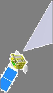
4 National Space Program of Korea GEO-KOMPSAT-1 GEO-KOMPSAT-2 4 (Courtesy, KARI)
5 Aerosol retrieval using satellite (LEO) measurement: past and present (sensor list, AOD spatial resolution) UV VIS NIR IR (OSCAR, Observing Systems Capability Analysis and Review Tool, WMO) TOMS (UV), 50 km x 50 km, 12:00 dsc GLI, (50km x 50km), 13:25 asc OMPS (UV/VIS) OMI (UV/VIS), 13km x 24km, 13:45 asc (6km x 6km), VIIRS 13:25 asc (VIS/IR) (1km x 1km), 10:30 dsc SCIAMACHY (UV/VIS/NIR/SWIR), 30km x 30 km, 10:00 dsc MERIS (VIS/NIR), 1km x 1km, 10:00 dsc MODIS (VIS/IR), 10km x 10km, 3km x 3km 13:30 asc, 10:30 dsc MISR (VIS/NIR), 17.6km x 17.6km 10:30 dsc SeaWiFS (VIS/NIR), 1.1km x 1.1km, 12:00desc POLDER (VIS/NIR), 5.3km x 6.2km, 15:20 asc ATSR 1/2, AATSR (VIS/IR), 10km x 10km, 3 km x 3 km, 10:00 dsc AVHRR 1/2/3 (VIS/NIR/MWIR), 8 km x 8 km, 14:00 asc
6 Aerosol retrieval using satellite (GEO) measurement: past and present (project, satellite, and sensors) Himawari-8 (1x1 km) COMS - GOCI(6x6km ), -MI (4x4km) Feng-Yun-3 (FY-3 series) VIRR (1,10 km) Feng-Yun-2 (FY-2 series) S-VISSR, 1.25km x 1.25km Feng-Yun-1 (FY-1 series) MVISR Himawari 1 st generation (Himawari 1-5) VISSR, 20km x 20km Himawari 2 nd generation (MTSAT-1R, 2) -JAMI, IMAGER, 1km x 1km Meteosat 2 nd Generation (Meteosat 8-11) SEVIRI, 3km x 3km GOES 1 st generation (GOES 1-7) - VISSR Meteosat 1 st Generation (Meteosat 1-7) - MVIRI GOES 2 nd generation (GOES 8-15)- IMAGER, 4km x 4km
")


 SI: KARI +")

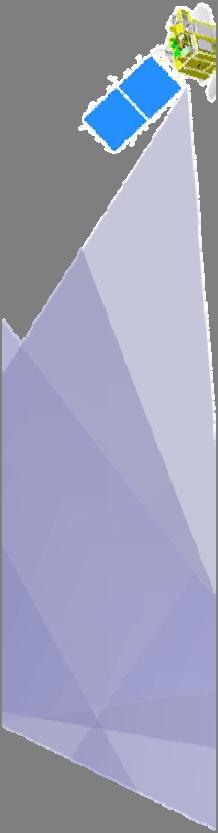
7 COMS (Geo-KOMPSAT-1) Mission: - Communication - Ocean Color - Meteorology Launch: Jun. 27, 2010 Orbit: GEO (128.2 E) SI: KARI + Astrium Mass at launch < 2497 kg Operational life : 7.7 years Launch vehicle : Ariane 5
8 Introduction Outline Geo-KOMPSAT-1 (COMS) MI GOCI-1 Geo-KOMPSAT-2 2(2A and 2B) AMI GOCI-2 GEMS Summary
 FD / ENH / LA NIMR Apr 2011 Fog Detection (FOG) East Asia NIMR Apr 2011 Snow/Sea Ice (SSI) FD / ENH + comp.")
9 COMS Data Products Group Product Name Area Alg. Dev. Remarks Scene Analysis Cloud Detection (CLD) FD / ENH / LA NIMR Apr 2011 Fog Detection (FOG) East Asia NIMR Apr 2011 Snow/Sea Ice (SSI) FD / ENH + comp. NIMR Jan 2012 Aerosol Index (AI) East Asia Pusan NU Apr 2011 Aerosol Optical Depth (AOD) East Asia YSU Jan 2012 Cloud Type (CT) FD / ENH / LA Cloud Apr 2011 Cloud Amount (CA) FD / ENH / LA Analysis SNU /ENH/LA Cloud (CLA) Cloud Phase (CP) FD / Jan 2012 Cloud Optical Thickness (COT) FD / ENH / LA Jan 2012 Cloud Top Temp./Height (CTTH) FD / ENH / LA SNU Apr 2011 Rainfall Intensity (RI) East Asia / LA Kangnung NU Aug 2011 Total Precipitable Water (TPW) East Asia Kyoungpook NU Jan 2012 Water vapor Upper Tropospheric Humidity (UTH) East Asia Kyoungpook NU Aug 2011 Surface Sea Surface Temperature (SST) FD / ENH + comp. SNU Aug 2011 property p Land Surface Temperature (LST) East Asia Kongju NU Jan 2012 Radiation Clear Sky Radiance (CSR) FD / ENH NIMR Jan 2012 Insolation (INS) FD / ENH Pukyoung NU Jan 2012 Outgoing Longwave Radiation (OLR) FD / ENH + comp. SNU Aug 2011 Wind Atmospheric Motion Vector (AMV) Enhanced Northern Hemi. NIMR Apr 2011 (Courtesy, NMSC, KMA)
 PRODUCTS Water-leaving radiance Normalized water leaving radiance Optical properties of water Chlorophyll TSS DESCRIPTION The radiance assumed to be measured at the very surface of the")

 Fishing ground probability index, fishing")
10 GOCI Data Processing System Ver1.2 (April 2013) Including more products 64bit Windows OS supported Ver1.3 (June, 2014) PRODUCTS Water-leaving radiance Normalized water leaving radiance Optical properties of water Chlorophyll TSS DESCRIPTION The radiance assumed to be measured at the very surface of the water under the atmosphere The water leaving radiance assumed to be measured at nadir, as if there was no atmosphere with the Sun at zenith K-coefficient Absorption coefficient Backscattering coefficient Concentration of phytoplankton chlorophyll in ocean water Total suspended sediment concentration in ocean water CDOM Colored dissolved organic matter concentration in ocean water Red tide Red tide tdeindex information ato Fishing ground information Underwater visibility Sea surface current vector Atm. & earth environment Water quality level Primary productivity Atmospheric correction improved Water quality Quality flag introduced (Courtesy, KOSC, KORDI) Fishing ground probability index, fishing ground prediction Degree of clarity of the ocean observed by the naked eye Sea surface current direction/speed Yellow dust, aerosol, Vegetation Index Coastal water quality levell estimation i The production of Organic compounds from carbon dioxide, principally through the process of photosynthesis
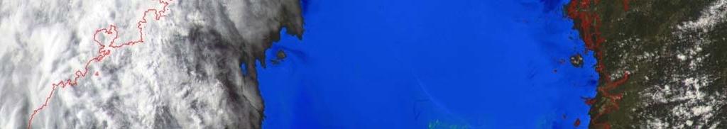
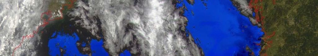
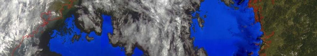
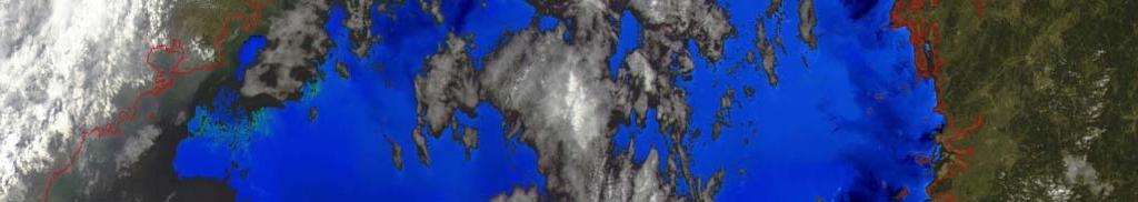
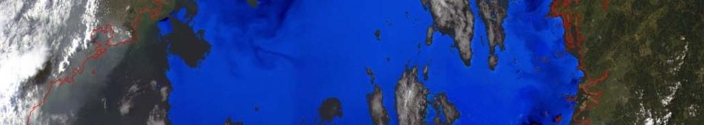
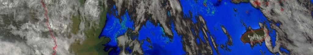
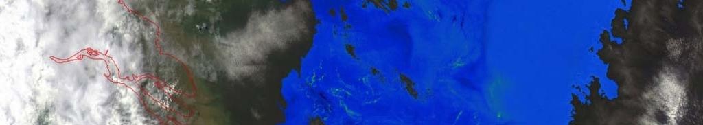
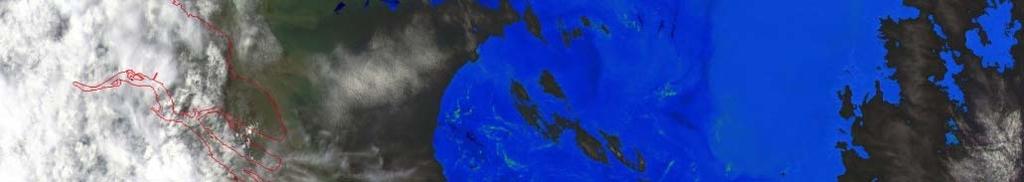
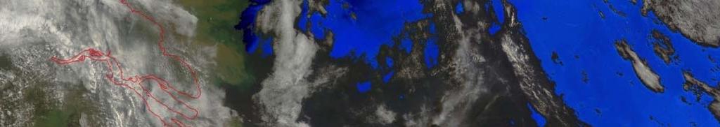
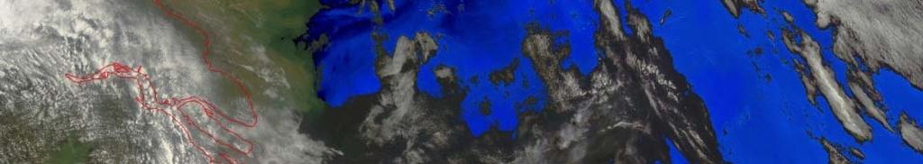
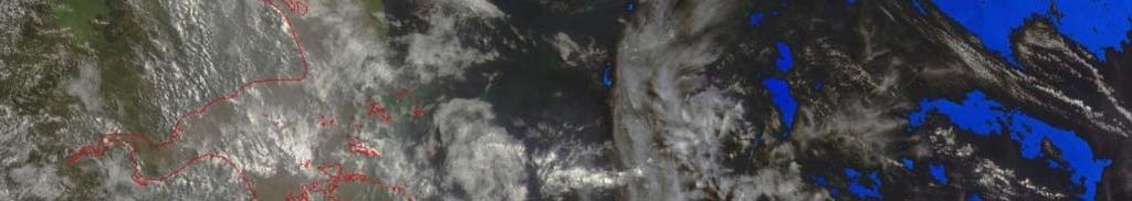
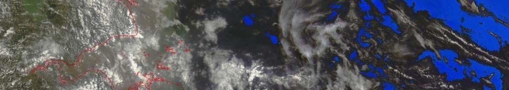
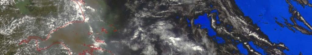
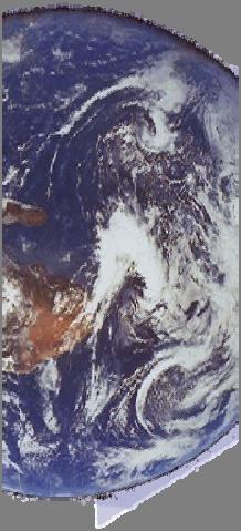
11 Monitoring Yellow Dust from COMS GOCI-1

 Low FMF (~0.")


 MODIS")


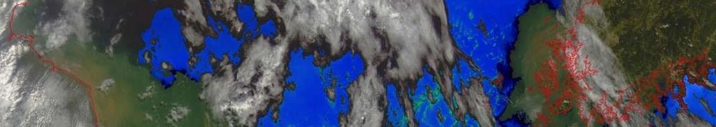
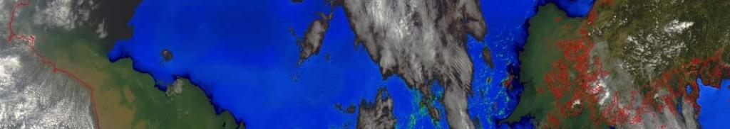
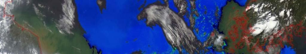
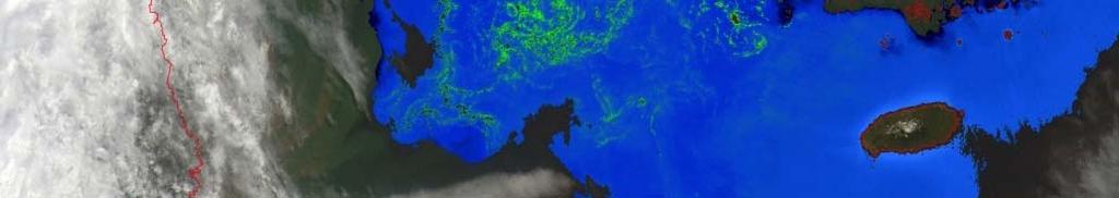
12 Yellow Dust Retrieval results : Dust case( ) Low FMF (~0.3): coarse particle GOCI RGB GOCI AOD (1hr interval) GOCI FMF GOCI SSA MI AOD (15min interval) MODIS AOD (2 times per day) MODIS FMF GOCI Aerosol Type (AOD > 0.3) HA, fine MA, fine NA, fine Mixture Dust NA/coarse FMF 0.6 ~ ~ ~ ~ ~ ~0.4 SSA 0.85~ ~ ~ ~ ~ ~

 - Spatial co-location : within 25km")


13 Validation results of AODs from GOCI and MI AERONET level 2.0 AOD data ( ) - Spatial co-location : within 25km at each AERONET site - Time co-location : ±30min AERONET at each satellite center measurement time AERONET lev2.0 Data [110 0 E E, 20 0 N-45 0 N] ~


14 Data Assimilation of GOCI with CMAQ where H: linear operator K: Kalman gain matrix B: error covariance of model O: error covariance of GOCI (Park et al., ACP, 2014)
15 (Park et al., ACP, 2014)
16 Surface reflectance (00h, ch0-3) (Mean value of surface reflectance over land) ; libradtran hh=00utc, ch=00ch month vs month vs month vs nm 0.20 month vs 2014 face reflectance Surf face reflectance Surf month vs 2011 month vs 2012 month vs 2013 month vs 2014 hh=00utc, ch=04ch 660nm Surf face refle ectance Surface reflectance Surface reflect ctance Month m onth vs 2011 m onth vs 2012 m onth vs nm m onth vs M o n th month vs 2011 month vs month vs nm month vs Surface reflectance Surface reflec ectance month vs 2011 Month month vs 2012 month vs 2013 month vs nm Month month vs 2011 month vs 2012 month vs 2013 month vs nm Surfa ace reflectance Month Month 0.36 month vs month vs month vs 2012 month vs 2012 month vs 2013 month vs 2013 month vs nm 865nm month vs Sur urface reflectance Month M A M J J A S O N D J F Month M A M J J A S O N D J F


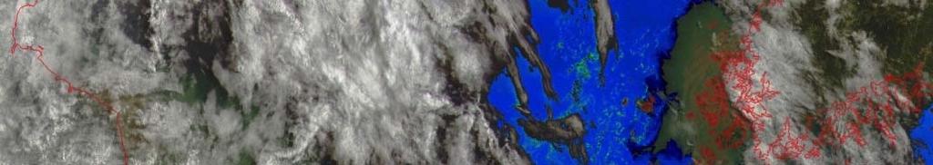
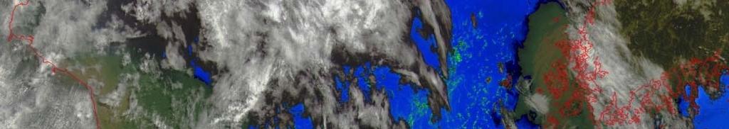
17 Time-series variations in GOCI-derived turbidity (Courtesy, KOSC, KORDI) areas of relatively high turbidity (in red) gradually decreased over time - clear water from open sea suppressed turbidity during flood tide around the time of high h tide, turbidity was remarkably lower - settlement of suspended particulates during the transition from flood to ebb tide and resulting lull in the tidal current


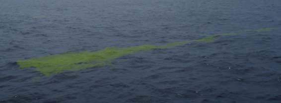


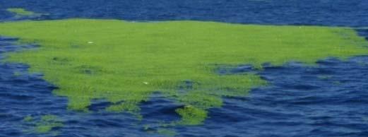


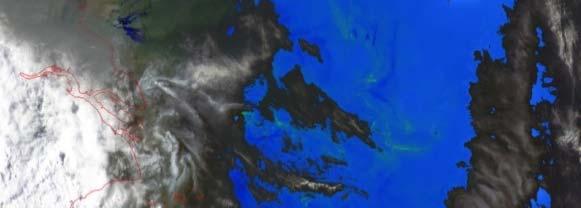


18 GOCI green tide monitoring KOREA Qingdao Jun. 13 Yellow sea July, 19 China Gunsan Mokpo Jeju j Island East/China Sea Yangtze river (Courtesy, KOSC, KORDI)
19 Introduction Outline Geo-KOMPSAT-1 (COMS) MI GOCI-1 Geo-KOMPSAT-2 2(2A and 2B) AMI GOCI-2 GEMS Summary

")


")
")
 1 hour 1")
")
20 GEO-KOMPSAT 2 2A Sat. : AMI 2B Sat. : GEMS, GOCI-2 (Twin Satellite) Launch: 2018 Specification 2A 2B Payload AMI GOCI-2 GEMS Lifetime 10 years Spectral range m nm nm Channels Spectral nm 0.6 resolution nm nm (sampling: 0.2 nm) Spatial 0.5 / 1 km 250 m@ eq 7x8km 2 resolution (Vis) 1 km Seoul 2 km (IR) Temporal 6 / hr (FD) 1 hour 1 hour resolution 12 / hr (NH) Imaging time 10 min(fd) 5 min (NH) 30 min 240 min(fd) 30 min
21 AMI 16 spectral bands; Full min; 0.5/1/2 km Spatial resolution Band No. Band Name Center Wavelength Min (um) Max (um) <Basic Spectral Bands> Band Width (Max, um) Resoluti on (km) SNR NEdT(K) (240/300 K) Radiometr ic Accuracy 1 VIS % 2 VIS % 3 VIS % 4 VIS % 5 NIR ( ) 5% 6 NIR % 7 IR /0.2 1K 8 IR /0.1(*) () 1K( ) 9 IR /0.1 1K 10 IR /0.12(*) 1K( ) 11 IR /0.1 1K 12 IR /0.15 1K 13 IR /0.2 1K 14 IR /0.1 1K 15 IR / K 16 IR /0.3 11K 1.1K SNR@100% albedo, NEdT@240/300K, calibration accuracy@100% albedo/300k SNR@max radiance 100% albedo calibration accuracy@max temperature 300K
22 GOCI-2 Spectral Bands Requirements (TBD) 13 Bands (GOCI : 8 Bands) Phytoplankton type verification, Nighttime Observation, Enhanced Atmospheric Correction Accuracy Band Band Center Bandwidth Nominal Maximum Ocean Saturation Maximum Cloud Radiance SNR : Nominal 2 /um/sr Radiance Radiance Radiance Radiance Radiance nm 20 nm nm 20 nm nm 20 nm nm 20 nm nm 20 nm nm 20 nm nm 20 nm nm 20 nm nm 10 nm nm 10 nm nm 20 nm nm 40 nm PAN 515 nm Still lack of IR channels for cloud masking
23 Satellite Remote Sensing of Atmospheric Composition Satellit e Senso rs TOMS ERS- 2 GOM E Terra Envisat Aura METOP GOSAT SCIA- MIPA MOPITT MACH HRDLS OMI TES IASI GOME2 TANSO S Y S-4, TEMPO GEMS Orbit PS PS PS PS PS PS PS PS PS PS LEO GEO Launc h (2018) O 3 O O O O O O O, O O H 2 O O O O O O CO O O O NO O O NO 2 O O O O O O O HNO 3 O O CH 4 O O O O O O HCHO O O O SO 2 O O O O O BrO O O O CO2 O O O Aeros ol O O O O O O O O : Column : Profile PS : Polar sun-synchronous GEO : Geostationary 23 (Courtesy, C.H. Song)


24 Measurements of aerosol & ozone with precursors h ( <345 nm) h (<420 nm) O O 3 HCHO NO Oxidation NO 2 t~an hour (OH, O 3, NO 3 ) O 3, RO 2 AOD, type, Height Aerosol
25 无法显示图像 计算机可能没有足够的内存以打开该图像, 也可能是该图像已损坏 请重新启动计算机, 然后重新打开该文件 如果仍然显示红色 x, 则可能需要删除该图像, 然后重新将其插入 Best fitting: full-scale radiance (Instrument vs. algorithm: ins trument limited telescope o ptics size) (Courtesy, K. Chance )
26 Specification of GEMS (Geostationary Environment Monitoring Spectrometer) Lifetime Reliability 10 yrs Specification years after IOT Spatial 5000 km x 5000 km coverage (5 o S ~ 45 o N, 75 o E ~ 145 o E) Longitude Duty cycle Spatial resolution SNR instrument level Data quantization Products E 8 times / 1 day (30 min for imaging+30 min rest) Gas: 7 km (NS) x 8 km Seoul Aerosol: 3.5 km (NS) x 8 km (EW) > 320nm > 430nm > 0.3 in N/S freq > 0.3 in E/W freq 14 bits O 3, NO 2, SO 2, HCHO, aerosol, AI, AAOD, AEH, Clouds, surface Spectral range Spectral resolution Keystone Smile Polarization Radiometric calibration accuracy Spectral Calibration accuracy Stray light Spectral feature Spectral stability nm Specification 0.6 nm (3 samples) < 0.2 pixel < 0.2 pixel < 2% ( nm) before correction < 4% (including std. lamp uncertainty) < 0.02 nm < 2% before image correction < 0.05% (peak-to-valley) within a ny 3nm wavelength window < 0.02 nm (1/10 spectral pixel) over daily imaging period


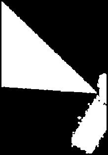
27 Projected FOV & GSD - NS Seoul : 7.0km Projected FOV Region of interest Normal operation For clear sector method
28 DOAS (Differential Optical Absorption Spectroscopy) I(, L) I 0 ( )exp 0 L j ABS (, p,t ) j j (L) (,l) (,l)dl R M N( ) Structured absorption feature Smooth -dependence Residual NO 2 O 4 O 3
 AOD AOD(bright sfc) NO O 3 (IR) 2 aerosol")


29 Synergy among GK-2 instruments UV-Vis 7x8 km resolution GEMS AOD(bright sfc) AOD AOD(bright sfc) NO O 3 (IR) 2 aerosol height DOM AOD SO 2 SSA FMF Met field Type(BC, Dust ) SO 2O3 Sfc property (Cloud,AMV..) Temperature Sfc Scpopety property GOCI-2 Vis NIR 250 m resolution + FD capability Aerosol info Cloud info. AMI Vis TIR kmresolution, 10 min.


30 Constellation of GEO Mission for Synergistic Products Improving coverage and consolidating socio-economic benefit GOES-R +TEMPO (America) Himawari AMI + GOCI2 + GEMS GEO KOMPSAT (Asia) FY Harmonizing data quality Sharing data with minimum time delay GMES S4 FCI + IRS + UVN MTG (Europe) Electro-L
31 Summary With the launch of COMS(GEO-KOMPSAT-1), observational capabiliti es in meteorology and oceanography have been expanded significant ly. Geo-KOMPSAT-2s are expected to provide even upgraded observati on products with the AMI, GOCI-2 and GEMS. Geo-KOMPSAT-2A and 2B are expected to provide information on ae rosol and trace gas amounts with the three instruments of AMI, GOCI- 2 and GEMS. GEMS is expected to provide information on trace gas and aerosol with their precursors in high spatial and temporal resolution - O 3 NO 2 HCHO SO 2 AOD/AI/AEH, (possibly CHOCHO, BrO) - Clouds, surface reflectance, UV radiation. Synergistic efforts to harmonize the products among AMI, GOCI-2 y g p g, and GEMS are highly desirable. Collaboration with the team of three different missions are essential for the success of GEO-KOMPSAT-2.
32 Acknowledgement Ministry of Science, ICT & future Planning (MSIP) KARI Ministry of Environment (MoE), Rep. of Korea NIER, MoE KEITI, MoE Korea Meteorological Administration NIMR NMSC Ministry of Oceans and Fisheries KOSC, KORDI
Jun Park National Meteorological Satellite Center Korea Meteorological Administration
 KMA Implementation Plan for Satellite Climate products Jun Park National Meteorological Satellite Center Korea Meteorological Administration jun.park@kma.go.kr Outline 1. Introduction : Current & Future
6 th ET SAT meeting, April 12 15, Geneva, Switzerland Satellite Programme of KMA
 6 th ET SAT meeting, April 12 15, Geneva, Switzerland Satellite Programme of KMA Korea Meteorological Administration National Meteorological Satellite Center Status of COMS COMS Heritage COM Design & Review
GEO New Mission and Synergy Joo-Hyung Ryu
 GEO New Mission and Synergy Joo-Hyung Ryu Korea Ocean Satellite Center Korea Institute Ocean Sciences & Technology GEMS GOCI-II GOCI Development : KARI & KIOST Cooperation Development Payload system -
Satellite observation of atmospheric dust
 Satellite observation of atmospheric dust Taichu Y. Tanaka Meteorological Research Institute, Japan Meteorological Agency 11 April 2017, SDS WAS: Dust observation and modeling @WMO, Geneva Dust observations
Sand and Dust Monitoring in RA II
 Sand and Dust Monitoring in RA II Xiang Fang National Satellite Meteorological Center,CMA Outline Dust products in RA II Validation of multi-satellite products Action Proposed Dust products in RA II Operational
Non-automatic weighing instrument. Automatic weighing instrument. Weighing instrument
 Verification of weighbridges Hu Manhong National Institute of Metrology Sept. 27, 2017 Contents 1. Introduction on weighing instruments and weighbridges 2. Construction of weighbridges and Visual inspection,
Role of Satellite and Remote Sensing in the Urban Environment
 Role of Satellite and Remote Sensing in the Urban Environment Jhoon Kim 1,2,5, Kelly Chance 2,5, Ben Veihelmann 3,5, Jay Al-Saadi 4,5 Pablo Saide 6 1 Yonsei University, Seoul, Korea 2 Harvard Smithonian
Atmospheric Measurements from Space
 Atmospheric Measurements from Space MPI Mainz Germany Thomas Wagner Satellite Group MPI Mainz Part 1: Basics Break Part 2: Applications Part 1: Basics of satellite remote sensing Why atmospheric satellite
Report Benefits and Challenges of Geostationary Ocean Colour Remote Sensing - Science and Applications. Antonio Mannino & Maria Tzortziou
 Report Benefits and Challenges of Geostationary Ocean Colour Remote Sensing - Science and Applications Antonio Mannino & Maria Tzortziou Time & Space Scales of OC Relevant Missions GOCI I & II Geo from
The Sentinel-4 Mission and its Atmospheric Composition Products
 This image cannot currently be displayed. The Sentinel-4 Mission and its Atmospheric Composition Products Ben Veihelmann, Yasjka Meijer, Jörg Langen, Paul Ingmann, Rob Koopman, Norrie Wright, Grégory Bazalgette
A 2016 CEOS Chair Initiative. Non-meteorological Applications for Next Generation Geostationary Satellites
 A 2016 CEOS Chair Initiative Committee on Earth Observation Satellites Non-meteorological Applications for Next Generation Geostationary Satellites Co-chaired by EUMETSAT (Holmlund), CSIRO (Schroeder),
Instrumentation planned for MetOp-SG
 Instrumentation planned for MetOp-SG Bill Bell Satellite Radiance Assimilation Group Met Office Crown copyright Met Office Outline Background - the MetOp-SG programme The MetOp-SG instruments Summary Acknowledgements:
Development of Heat Transfer Coefficient and Friction Factor Correlations for Serrated Fins in Water Medium using CFD
 Journal of Physical Science and Application 5 (3) (2015) 238-248 doi: 10.17265/2159-5348/2015.03.010 D DAVID PUBLISHING Development of Heat Transfer Coefficient and Friction Factor Correlations for Serrated
EPS-SG Candidate Observation Missions
 EPS-SG Candidate Observation Missions 3 rd Post-EPS User Consultation Workshop Peter Schlüssel Slide: 1 EPS-SG benefits to activities of NMSs Main Payload High-Resolution Infrared Sounding Microwave Sounding
Current Application of Vicarious Calibration for Geostationary Ocean Color Imager (GOCI) DATA
 DATA") Current Application of Vicarious Calibration for Geostationary Ocean Color Imager (GOCI) DATA On behalf of Jae-Hyun Ahn & Young-je Park, Seongick CHO(Secondment at Astrium SAS, France) Korea Ocean Satellite
Current Application of Vicarious Calibration for Geostationary Ocean Color Imager (GOCI) DATA On behalf of Jae-Hyun Ahn & Young-je Park, Seongick CHO(Secondment at Astrium SAS, France) Korea Ocean Satellite
KOREA GEOSTATIONARY SATELLITE PROGRAM : COMMUNICATION, OCEAN, AND METEOROLOGICAL SATELLITE(COMS)
") KOREA GEOSTATIONARY SATELLITE PROGRAM : COMMUNICATION, OCEAN, AND METEOROLOGICAL SATELLITE(COMS) Mi-Lim Ou, Jae-Gwang-Won, Sung-Rae Chung, Hye-Sook Lee, and Ae-Sook Suh Korea Meteorological Administration
KOREA GEOSTATIONARY SATELLITE PROGRAM : COMMUNICATION, OCEAN, AND METEOROLOGICAL SATELLITE(COMS) Mi-Lim Ou, Jae-Gwang-Won, Sung-Rae Chung, Hye-Sook Lee, and Ae-Sook Suh Korea Meteorological Administration
GSICS UV Sub-Group Activities
 GSICS UV Sub-Group Activities Rosemary Munro with contributions from NOAA, NASA and GRWG UV Subgroup Participants, in particular L. Flynn 1 CEOS Atmospheric Composition Virtual Constellation Meeting (AC-VC)
Long-Term Time Series of Water Vapour Total Columns from GOME, SCIAMACHY and GOME-2
 Graphics: ESA Graphics: ESA Graphics: ESA Long-Term Time Series of Water Vapour Total Columns from GOME, SCIAMACHY and GOME-2 S. Noël, S. Mieruch, H. Bovensmann, J. P. Burrows Institute of Environmental
MSG system over view
 MSG system over view 1 Introduction METEOSAT SECOND GENERATION Overview 2 MSG Missions and Services 3 The SEVIRI Instrument 4 The MSG Ground Segment 5 SAF Network 6 Conclusions METEOSAT SECOND GENERATION
Current Status and Future Plan of KMA Satellite Program
 The 5th Asia-Oceania Meteorological Satellite Users Conference(2014. 11. 19) Current Status and Future Plan of KMA Satellite Program Sang Jin LYU National Meteorological Satellite Center Korea Meteorological
The Copernicus Sentinel-5 Mission: Daily Global Data for Air Quality, Climate and Stratospheric Ozone Applications
 SENTINEL-5 The Copernicus Sentinel-5 Mission: Daily Global Data for Air Quality, Climate and Stratospheric Ozone Applications Yasjka Meijer RHEA for ESA, Noordwijk, NL 15/04/2016 Co-Authors: Jörg Langen,
The current status of FY-3D
 The current status of FY-3D Xiang Fang National Satellite Meteorological Center, China Meteorological Administration (NSMC/CMA) OUTLINE Overview Key instruments onboard FY-3D Products and data service
CMA Consideration on early-morning orbit satellite
 CMA Consideration on early-morning orbit satellite National Satellite Meteorological Center,CMA Yang Jun CGMS 40 in Lugano, 5-9 Nov., 2012 Outline Background Gap analysis on the sounding data coverage
GEMS. Nimbus 4, Nimbus7, NOAA-9, NOAA11, NOAA16, NOAA17
 GEMS (Geostationary Environment Monitoring Spectrometer) SBUV,BUV TOMS (50x50km 2 ) Nimbus7, METEOR-3, ADEOS, Earth-probe GOME1/2 (40x40km 2 ) ERS-2 SCIAMACHY (30x60km 2 ) OMI (13x24km2) OMPS (50x50km
OSSE to infer the impact of Arctic AMVs extracted from highly elliptical orbit imagery
 OSSE to infer the impact of Arctic AMVs extracted from highly elliptical orbit imagery L. Garand 1 Y. Rochon 1, S. Heilliette 1, J. Feng 1, A.P. Trishchenko 2 1 Environment Canada, 2 Canada Center for
TEMPO Aerosols. Need for TEMPO-ABI Synergy
 TEMPO Aerosols Need for TEMPO-ABI Synergy Omar Torres, Hiren Jethva, Changwoo Ahn CEOS - 2018 NOAA-College Park May 04, 2018 Use of near UV Satellite Observations for retrieving aerosol properties over
ESA Climate Change Initiative (CCI)
") ESA Climate Change Initiative (CCI) New ESA Programme with the aim to contribute to worldwide efforts to generate Essential Climate Variables (ECVs) C. Zehner Barcelona, 07/09/2009 Two climate action paths
ESA Climate Change Initiative (CCI) New ESA Programme with the aim to contribute to worldwide efforts to generate Essential Climate Variables (ECVs) C. Zehner Barcelona, 07/09/2009 Two climate action paths
Operation and Calibration Status of GOCI
 2016 GSICS Data & Research Working Groups Meeting @ JAXA, Tsukuba, 29. Feb. 2016 Operation and Calibration Status of GOCI Seongick CHO Korea Ocean Satellite Center, Korea Institute of Ocean Science and
Aerosol measurements from Space. Gerrit de Leeuw FMI & Uni of Helsinki, Finland & TNO, Utrecht, Netherlands
 Aerosol measurements from Space Gerrit de Leeuw FMI & Uni of Helsinki, Finland & TNO, Utrecht, Netherlands ACCENT AT-2 Follow-up meeting Mainz, 22 June 2009 ACCENT AT-2 Outcomes The Remote Sensing of Tropospheric
Satellite observations of aerosols and related gases and applications for aerosol deposition
 Satellite observations of aerosols and related gases and applications for aerosol deposition Mian Chin 1, HongbinYu 1, P.K. Bhartia 1, JassimAl-Saadi 2, ShobhaKongragunta 3, Alexei Lyapustin 1, Omar Torres
Chapter 4 Nadir looking UV measurement. Part-I: Theory and algorithm
 Chapter 4 Nadir looking UV measurement. Part-I: Theory and algorithm -Aerosol and tropospheric ozone retrieval method using continuous UV spectra- Atmospheric composition measurements from satellites are
Satellite remote sensing of trace gases - Nadir sounding geometry. Cathy Clerbaux, DR CNRS, LATMOS/IPSL
 Satellite remote sensing of trace gases - Nadir sounding geometry Cathy Clerbaux, DR CNRS, LATMOS/IPSL Cathy.clerbaux@latmos.ipsl.fr Sounding the bottom of the atmosphere Endeavour STS-130 Atmospheric
VALIDATION OF INSAT-3D DERIVED RAINFALL. (Submitted by Suman Goyal, IMD) Summary and Purpose of Document
 Summary and Purpose of Document") WORLD METEOROLOGICAL ORGANIZATION COMMISSION FOR BASIC SYSTEMS OPEN PROGRAMME AREA GROUP ON INTEGRATED OBSERVING SYSTEMS INTER-PROGRAMME EXPERT TEAM ON SATELLITE UTILIZATION AND PRODUCTS SECOND SESSION
WORLD METEOROLOGICAL ORGANIZATION COMMISSION FOR BASIC SYSTEMS OPEN PROGRAMME AREA GROUP ON INTEGRATED OBSERVING SYSTEMS INTER-PROGRAMME EXPERT TEAM ON SATELLITE UTILIZATION AND PRODUCTS SECOND SESSION
Non-meteorological Applications for Next Generation Geostationary Meteorological Satellites
 Non-meteorological Applications for Next Generation Geostationary Meteorological Satellites Toshiyuki KURINO Satellite Program Division Japan Meteorological Agency Topics Advanced GEO for Earth Observation
Satellite remote sensing of NO 2
 Satellite remote sensing of NO 2 views from outside Steffen Beirle Satellite Group MPI Mainz UV-vis satellite instruments Current nadir UV/vis satellite instruments: GOME 1/2, SCIAMACHY, OMI Nadir: probing
Status report on the. systems by KMA. Presented to CGMS-43 plenary session, agenda item [E.1]
![Status report on the. systems by KMA. Presented to CGMS-43 plenary session, agenda item [E.1]](/thumbs/89/97785525.jpg "Status report on the. systems by KMA. Presented to CGMS-43 plenary session, agenda item [E.1]") Status report on the current and future satellite systems by KMA Presented to CGMS-43 plenary session, agenda item [E.1] Current Geo-Satellites : COMS COMS(Communication, Ocean, and Meteorological Satellite)
Status report on the current and future satellite systems by KMA Presented to CGMS-43 plenary session, agenda item [E.1] Current Geo-Satellites : COMS COMS(Communication, Ocean, and Meteorological Satellite)
David Edwards, Jérôme Barré and Helen Worden (NCAR) Arlindo da Silva (NASA GSFC) is sponsored by the National Science Foundation.
 Arlindo da Silva (NASA GSFC) is sponsored by the National Science Foundation.") The atmospheric composition geostationary satellite constellation for air quality and climate science: Evaluating performance with Observation System Simulation Experiments (OSSEs) David Edwards, Jérôme
The atmospheric composition geostationary satellite constellation for air quality and climate science: Evaluating performance with Observation System Simulation Experiments (OSSEs) David Edwards, Jérôme
Operational systems for SST products. Prof. Chris Merchant University of Reading UK
 Operational systems for SST products Prof. Chris Merchant University of Reading UK Classic Images from ATSR The Gulf Stream ATSR-2 Image, ƛ = 3.7µm Review the steps to get SST using a physical retrieval
Status of GOCI-II Development
 Status of GOCI-II Development Seongick CHO On the behalf of Dr. YoungJe Park, Director of KOSC Korea Ocean Satellite Center (KOSC) Korea Institute of Ocean Science & Technology (KIOST) IOCS Meeting 2015,
Observing CO 2 from a highly elliptical orbit for studies of the carbon cycle in the Arctic and boreal regions
 Observing CO 2 from a highly elliptical orbit for studies of the carbon cycle in the Arctic and boreal regions Ray Nassar 1, Chris Sioris 2, Dylan B.A. Jones 3, Kaley A. Walker 3, Chris McLinden 4, C.
Planning for next generation geostationary satellites (GK-2A) of Korea Meteorological Administration (KMA)
 of Korea Meteorological Administration (KMA)") Planning for next generation geostationary satellites (GK-2A) of Korea Meteorological Administration (KMA) Yunbok Lee & Geun-Hyeok Ryu 1 NMSC Goal To operate timely COMS, to gather reliable satellite data
Planning for next generation geostationary satellites (GK-2A) of Korea Meteorological Administration (KMA) Yunbok Lee & Geun-Hyeok Ryu 1 NMSC Goal To operate timely COMS, to gather reliable satellite data
Preparation for Himawari 8
 Preparation for Himawari 8 Japan Meteorological Agency Meteorological Satellite Center Hidehiko MURATA ET SUP 8, WMO HQ, Geneva, 14 17 April 2014 1/18 Introduction Background The Japan Meteorological Agency
EUMETSAT STATUS AND PLANS
 1 EUM/TSS/VWG/15/826793 07/10/2015 EUMETSAT STATUS AND PLANS François Montagner, Marine Applications Manager, EUMETSAT WMO Polar Space Task Group 5 5-7 October 2015, DLR, Oberpfaffenhofen PSTG Strategic
Developments on air quality modeling, Prof. Dr. Hennie Kelder Royal Netherlands Meteorological Inst KNMI University of Technology, Eindhoven
 Developments on air quality modeling, satellite observations and services in Europ Prof. Dr. Hennie Kelder Royal Netherlands Meteorological Inst KNMI University of Technology, Eindhoven GMES: Global Monitoring
Aerosol Retrieved from MODIS: Algorithm, Products, Validation and the Future
 Aerosol Retrieved from MODIS: Algorithm, Products, Validation and the Future Presented by: Rob Levy Re-presenting NASA-GSFC s MODIS aerosol team: Y. Kaufman, L. Remer, A. Chu,, C. Ichoku,, R. Kleidman,,
GOSAT update. June Prepared by JAXA EORC Presented by David Crisp
 CEOS AC-VC GOSAT update June Prepared by JAXA EORC Presented by David Crisp GOSAT & GOSAT-2 Organization ORGANIZATION GOSAT is the joint project of JAXA, MOE (Ministry of the Environment) and NIES (National
Status of the Sentinel-5 Precursor Presented by C. Zehner S5p, S4, and S5 Missions Manager - ESA
 Status of the Sentinel-5 Precursor Presented by C. Zehner S5p, S4, and S5 Missions Manager - ESA European response to global needs: to manage the environment, to mitigate the effects of climate change
UV/VIS BACKSCATTERED SUN LIGHT RETRIEVALS FROM SPACE BORN PLATFORMS. G. Gonzalez Abad With a lot of help from K. Chance, X. Liu, C.
 UV/VIS BACKSCATTERED SUN LIGHT RETRIEVALS FROM SPACE BORN PLATFORMS G. Gonzalez Abad With a lot of help from K. Chance, X. Liu, C. Miller and others OVERVIEW A bit of history on UV-VIS backscatter spectrometers
Lecture 4b: Meteorological Satellites and Instruments. Acknowledgement: Dr. S. Kidder at Colorado State Univ.
 Lecture 4b: Meteorological Satellites and Instruments Acknowledgement: Dr. S. Kidder at Colorado State Univ. US Geostationary satellites - GOES (Geostationary Operational Environmental Satellites) US
Cloud masking as cross-cutting issue
 Cloud masking as cross-cutting issue Presentation to CEOS/WGCV activity project planning meeting Rainer Hollmann, Cornelia Schlundt, Satellite based Climate Monitoring Deutscher Wetterdienst Outline Need
Operational Uses of Bands on the GOES-R Advanced Baseline Imager (ABI) Presented by: Kaba Bah
 Presented by: Kaba Bah") Operational Uses of Bands on the GOES-R Advanced Baseline Imager (ABI) Presented by: Kaba Bah Topics: Introduction to GOES-R & ABI ABI individual bands Use of band differences ABI derived products Conclusions
Operational Uses of Bands on the GOES-R Advanced Baseline Imager (ABI) Presented by: Kaba Bah Topics: Introduction to GOES-R & ABI ABI individual bands Use of band differences ABI derived products Conclusions
EUMETSAT Activities Related to Climate
 EUMETSAT Activities Related to Climate Jörg Schulz joerg.schulz@eumetsat.int Slide: 1 What we do USER REQUIREMENTS European National Meteorological Services Operating Agency! European Space Industry Private
Satellite remote sensing of aerosols & clouds: An introduction
 Satellite remote sensing of aerosols & clouds: An introduction Jun Wang & Kelly Chance April 27, 2006 junwang@fas.harvard.edu Outline Principals in retrieval of aerosols Principals in retrieval of water
Meteorological Missions
 Meteorological Missions Guido Levrini ESA GSC Space Segment Programme Manager Page 1 Introduction ESA initiated Europe s entry into satellite meteorology with the development and launch of the first Meteosat
PHEOS - Weather, Climate, Air Quality
 Aerosol & cloud remote sensing over the Arctic : perspectives for the PHEMOS and meteorological imager payloads on the PCW mission Norm O Neill, Auromeet Saha, U. de Sherbrooke Chris E. Sioris, Jack McConnell,
Preparation for FY-4A. (Submitted by Xiang Fang, CMA)
") WORLD METEOROLOGICAL ORGANIZATION COMMISSION FOR BASIC SYSTEMS OPEN PROGRAMME AREA GROUP ON INTEGRATED OBSERVING SYSTEMS EXPERT TEAM ON SATELLITE UTILIZATION AND PRODUCTS ET-SUP-8/Doc. 10.3 (2.IV.2014)
WORLD METEOROLOGICAL ORGANIZATION COMMISSION FOR BASIC SYSTEMS OPEN PROGRAMME AREA GROUP ON INTEGRATED OBSERVING SYSTEMS EXPERT TEAM ON SATELLITE UTILIZATION AND PRODUCTS ET-SUP-8/Doc. 10.3 (2.IV.2014)
Physicochemical and Optical Properties of Aerosols in South Korea
 Physicochemical and Optical Properties of Aerosols in South Korea Seungbum Kim, Sang-Sam Lee, Jeong-Eun Kim, Ju-Wan Cha, Beom-Cheol Shin, Eun-Ha Lim, Jae-Cheol Nam Asian Dust Research Division NIMR/KMA
History of Aerosol Remote Sensing. Mark Smithgall Maria Zatko 597K Spring 2009
 History of Aerosol Remote Sensing Mark Smithgall Maria Zatko 597K Spring 2009 Aerosol Sources Anthropogenic Biological decomposition from fertilizer and sewage treatment (ex. ammonium) Combustion of fossil
The Status Report of FY-2F
 Seventh Session of the Expert Team on Satellite Utilization and Products The Status Report of FY-2F Presented by Xiang Fang National Satellite Meteorological Center (NSMC) China Meteorological Administration
Astrid Bracher PHYTOOPTICS group, Climate Sciences, AWI & IUP, University Bremen
 Breakout session "Hyperspectral science and applications for shelf and open ocean processes" Hyperspectral ocean color imagery and applications to studies of phytoplankton ecology Astrid Bracher PHYTOOPTICS
Arctic Weather Every 10 Minutes: Design & Operation of ABI for PCW
 Arctic Weather Every 10 Minutes: Design and Operation of ABI for PCW Dr. Paul C. Griffith and Sue Wirth 31st Space Symposium, Technical Track, Colorado Springs, Colorado This document is not subject to
Tropospheric Chemistry from space: past, present and future science. Paul Palmer [Slides from Ken Juckes, Ben Veihelmann, and Kelly Chance]
![Tropospheric Chemistry from space: past, present and future science. Paul Palmer [Slides from Ken Juckes, Ben Veihelmann, and Kelly Chance]](/thumbs/88/116538095.jpg "Tropospheric Chemistry from space: past, present and future science. Paul Palmer [Slides from Ken Juckes, Ben Veihelmann, and Kelly Chance]") Tropospheric Chemistry from space: past, present and future science Paul Palmer [Slides from Ken Juckes, Ben Veihelmann, and Kelly Chance] Surface processes, atmospheric chemistry and transport result
Tropospheric Chemistry from space: past, present and future science Paul Palmer [Slides from Ken Juckes, Ben Veihelmann, and Kelly Chance] Surface processes, atmospheric chemistry and transport result
Comparison between MERIS and GOCI in regional seas around Korea
 Comparison between MERIS and GOCI in regional seas around Korea Young-Je Park, Yu-Hwan Ahn, Jung-Mi Yoo KOSC staff Korea Ocean Satellite Center (KOSC), Korea Ocean Research and Development Institute (KODI)
Current status of GK-2A AMV algorithm in NMSC/KMA
 Current status of GK-2A AMV algorithm in NMSC/KMA 23 April 2018 Soo Min Oh, Byung-il Lee, Sung-Rae Chung, Seonkyun Baek NMSC/KMA 국가기상위성센터 National Meteorological Satellite Center Contents Status of COMS
Yi Liu TanSat Science Team
 12th International Workshop on Greenhouse Gas Measurements from Space The Pre Launch Status of TanSat Mission Yi Liu TanSat Science Team Institute of Atmospheric Physics, Chinese Academy of Sciences 9
Detection of ship NO 2 emissions over Europe from satellite observations
 Detection of ship NO 2 emissions over Europe from satellite observations Huan Yu DOAS seminar 24 April 2015 Ship Emissions to Atmosphere Reporting Service (SEARS project) Outline Introduction Shipping
Status report on the current and future satellite systems by CMA. Presented to CGMS46-CMA-WP-01, Plenary session, agenda item D.1
 Status report on the current and future satellite systems by CMA Presented to CGMS46-CMA-WP-01, Plenary session, agenda item D.1 Overview - Planning of CMA satellite systems FengYun Meteorological Satellites
A proposal for a new IOCCG working group. Theme: ocean colour observations from the geostationary orbit. Proposed by David Antoine
 A proposal for a new IOCCG working group Theme: ocean colour observations from the geostationary orbit Proposed by David Antoine IOCCG working group Ocean colour from the geostationary orbit Plan - Motivations
Recent Update on MODIS C6 and VIIRS Deep Blue Aerosol Products
 Recent Update on MODIS C6 and VIIRS Deep Blue Aerosol Products N. Christina Hsu, Photo taken from Space Shuttle: Fierce dust front over Libya Corey Bettenhausen, Andrew M. Sayer, and Rick Hansell Laboratory
Introduction of GOCI and GOCI-II Mission with Lunar Calibration
 Lunar Calibration Workshop, EUMETSAT, 14/12/04 Introduction of GOCI and GOCI-II Mission with Lunar Calibration Seongick CHO Korea Ocean Satellite Center, Korea Institute of Ocean Science and Technology
NASA's Plankton, Aerosol, Cloud, ocean Ecosystem (PACE) mission update
 mission update") NASA's Plankton, Aerosol, Cloud, ocean Ecosystem (PACE) mission update Antonio Mannino1, Jeremy Werdell1, Brian Cairns2 NASA GSFC1 and GISS2 Acknowledgments: PACE Team https://pace.gsfc.nasa.gov 1 Outline
NASA's Plankton, Aerosol, Cloud, ocean Ecosystem (PACE) mission update Antonio Mannino1, Jeremy Werdell1, Brian Cairns2 NASA GSFC1 and GISS2 Acknowledgments: PACE Team https://pace.gsfc.nasa.gov 1 Outline
Interpretation of Polar-orbiting Satellite Observations. Atmospheric Instrumentation
 Interpretation of Polar-orbiting Satellite Observations Outline Polar-Orbiting Observations: Review of Polar-Orbiting Satellite Systems Overview of Currently Active Satellites / Sensors Overview of Sensor
Global Space-based Inter-Calibration System (GSICS) Infrared Reference Sensor Traceability and Uncertainty
 Infrared Reference Sensor Traceability and Uncertainty") Global Space-based Inter-Calibration System (GSICS) Infrared Reference Sensor Traceability and Uncertainty Tim Hewison (EUMETSAT) Thomas Pagano (NASA/JPL) Dave Tobin (NOAA/CIMSS) Masaya Takahashi (JMA)
Global Space-based Inter-Calibration System (GSICS) Infrared Reference Sensor Traceability and Uncertainty Tim Hewison (EUMETSAT) Thomas Pagano (NASA/JPL) Dave Tobin (NOAA/CIMSS) Masaya Takahashi (JMA)
Remote Sensing I: Basics
 Remote Sensing I: Basics Kelly M. Brunt Earth System Science Interdisciplinary Center, University of Maryland Cryospheric Science Laboratory, Goddard Space Flight Center kelly.m.brunt@nasa.gov (Based on
A new perspective on aerosol direct radiative effects in South Atlantic and Southern Africa
 A new perspective on aerosol direct radiative effects in South Atlantic and Southern Africa Ian Chang and Sundar A. Christopher Department of Atmospheric Science University of Alabama in Huntsville, U.S.A.
Vicarious calibration of GLI by global datasets. Calibration 5th Group Hiroshi Murakami (JAXA EORC)
") Vicarious calibration of GLI by global datasets Calibration 5th Group Hiroshi Murakami (JAXA EORC) ADEOS-2 PI workshop March 2004 1 0. Contents 1. Background 2. Operation flow 3. Results 4. Temporal change
Vicarious calibration of GLI by global datasets Calibration 5th Group Hiroshi Murakami (JAXA EORC) ADEOS-2 PI workshop March 2004 1 0. Contents 1. Background 2. Operation flow 3. Results 4. Temporal change
RGB Experts and Developers Workshop - Introduction Tokyo, Japan 7-9 Nov 2017
 RGB Experts and Developers Workshop - Introduction Tokyo, Japan 7-9 Nov 2017 Workshop Objectives Review of existing RGB standards Reconfirm and extend existing standards (new multi-spectral imagers) Stimulate
Eyja volcanic ash retrievals by using MODIS data
 INGV Eyja volcanic ash retrievals by using MODIS data S. Corradini, L. Merucci, A. Piscini Remote Sensing Group INGV (Rome) ESRIN May 26-27, 2010 Outline Ash retrieval algorithms in the TIR spectral range
The CEOS Atmospheric Composition Constellation (ACC) An Example of an Integrated Earth Observing System for GEOSS
 An Example of an Integrated Earth Observing System for GEOSS") The CEOS Atmospheric Composition Constellation (ACC) An Example of an Integrated Earth Observing System for GEOSS Presentation Authors: E. Hilsenrath NASA, C. Zehner ESA, J. Langen ESA, J. Fishman NASA
The CEOS Atmospheric Composition Constellation (ACC) An Example of an Integrated Earth Observing System for GEOSS Presentation Authors: E. Hilsenrath NASA, C. Zehner ESA, J. Langen ESA, J. Fishman NASA
THE EUMETSAT SATELLITE PROGRAMMES AN OVERVIEW FROM NOW TO THE FUTURE
 THE EUMETSAT SATELLITE PROGRAMMES AN OVERVIEW FROM NOW TO THE FUTURE Kenneth Holmlund EUMETSAT And many other contributors from EUMETSAT and its partners Current EUMETSAT satellite fleet METOP -A and -B
STATUS OF JAPANESE METEOROLOGICAL SATELLITES AND RECENT ACTIVITIES OF MSC
 STATUS OF JAPANESE METEOROLOGICAL SATELLITES AND RECENT ACTIVITIES OF MSC Daisaku Uesawa Meteorological Satellite Center, Japan Meteorological Agency Abstract MTSAT-1R is the current operational Japanese
4.1 New Generation Satellite Data and Nowcasting Products: Himawari
 4.1 New Generation Satellite Data and Nowcasting Products: Himawari SCOPE-Nowcasting-EP 18-20 September 2017 Koji Yamashita kobo.yamashita@met.kishou.go.jp Meteorological Satellite Center (MSC) Japan Meteorological
CHAPTER CONTENTS. Page
 CHAPTER CONTENTS CHAPTER 3. REMOTE-SENSING INSTRUMENTS... 859 3.1 Instrument basic characteristics... 859 3.1.1, swath and observing cycle... 859 3.1.2 Spectral range: radiometers and spectrometers...
EUMETSAT products and services for monitoring storms - New missions, more data and more meteorological products
 EUMETSAT products and services for monitoring storms - New missions, more data and more meteorological products Jochen Grandell 1 EUM/RSP/VWG/17/921460 Outline Overview of EUMETSAT missions Current...and
KORUS-AQ campaign: Overview and Status (1 May 14 June 2016)
") KORUS-AQ campaign: Overview and Status (1 May 14 June 2016) Jeong-Hoo Park 1, James Crawford 2, Jhoon Kim 3, Gangwoong Lee 4, Rokjin Park 5, Ji-Hyung Hong 1, Lim-Seok Chang 1, Jay Al-Saadi 2, Louisa Emmons
KORUS-AQ campaign: Overview and Status (1 May 14 June 2016) Jeong-Hoo Park 1, James Crawford 2, Jhoon Kim 3, Gangwoong Lee 4, Rokjin Park 5, Ji-Hyung Hong 1, Lim-Seok Chang 1, Jay Al-Saadi 2, Louisa Emmons
GCOM-C/SGLI and its Lunar Calibration
 GCOM-C/SGLI and its Lunar Calibration Lunar Calibration Workshop December 1-4, 2014 JAXA/GCOM Proj. Yoshihiko Okamura (okamura.yoshihiko@jaxa.jp) 1. Overview of GCOM-C satellite and SGLI (1) Global Change
GEOG Lecture 8. Orbits, scale and trade-offs
 Environmental Remote Sensing GEOG 2021 Lecture 8 Orbits, scale and trade-offs Orbits revisit Orbits geostationary (36 000 km altitude) polar orbiting (200-1000 km altitude) Orbits revisit Orbits geostationary
Next generation of EUMETSAT microwave imagers and sounders: new opportunities for cloud and precipitation retrieval
 Next generation of EUMETSAT microwave imagers and sounders: new opportunities for cloud and precipitation retrieval Christophe Accadia, Sabatino Di Michele, Vinia Mattioli, Jörg Ackermann, Sreerekha Thonipparambil,
THE EUMETSAT SATELLITE PROGRAMMES. Kenneth Holmlund EUMETSAT. R. Stuhlmann, P. Schlüssel, AN OVERVIEW FROM NOW TO THE FUTURE
 THE EUMETSAT SATELLITE PROGRAMMES AN OVERVIEW FROM NOW TO THE FUTURE Kenneth Holmlund EUMETSAT R. Stuhlmann, P. Schlüssel, D. Klaes, R. Munro, F. Montagner, J. Grandell, C. Hanson S. Rota, M. Cohen And
Application of Aura/OMI PBL SO 2 product for estimating SO 2 emissions and future enhancements from new satellite missions
 Application of Aura/OMI PBL SO 2 product for estimating SO 2 emissions and future enhancements from new satellite missions 1 N. Krotkov, 2 V. Fioletov, 3,1 K. Yang, 4,1 Can Li, 3 R. Dickerson & Aura/OMI
Cross-calibration of Geostationary Satellite Visible-channel Imagers Using the Moon as a Common Reference
 Cross-calibration of Geostationary Satellite Visible-channel Imagers Using the Moon as a Common Reference Thomas C. Stone U.S. Geological Survey, Flagstaff AZ, USA 27 30 August, 2012 Motivation The archives
Icing detection from geostationary satellite data over Korea and Japan using machine learning approaches
 Icing detection from geostationary satellite data over Korea and Japan using machine learning approaches Seongmun Sim 1 Seonghyeon Ha 1 Junghee Lee 1 Jungho Im1 1 School of Urban and Environmental Engineering,
Status of Libya-4 Activities - RAL
 Status of Libya-4 Activities - RAL Dr David L Smith Preparation for reprocessing AATSR Long term drift correction LUT version 2.09 implemented in reprocessing V3.00 available based on revised BRF modelling
MTG imaging channels in the solar domain and 3.7 microns for retrieval of cloud and aerosol microphysical properties
 MTG imaging channels in the solar domain and 3.7 microns for retrieval of cloud and aerosol microphysical properties Bizzarro BIZZARRI, Elisa CARBONI, Francesco DI PAOLA and Gian Luigi LIBERTI Consiglio
ispex.nl/en/ispex ispex measure aerosols with your smartphone
 ispex.nl/en/ispex ispex measure aerosols with your smartphone Status of TROPOMI on Sentinel 5 Precursor Pepijn Veefkind veefkind@knmi.nl KNMI TU-Delft sentinel-5 precursor GMES ATMOSPHERE MISSION IN POLAR
HICO Calibration and Atmospheric Correction
 HICO Calibration and Atmospheric Correction Curtiss O. Davis College of Earth Ocean and Atmospheric Sciences Oregon State University, Corvallis, OR, USA 97331 cdavis@coas.oregonstate.edu Oregon State Introduction
Satellite P rogram s & Applications of K M A : Current & Future
 Satellite P rogram s & Applications of K M A : Current & Future Sang Jin LYU National Meteorological Satellite Center Korea Meteorological Administration sjlyu@korea.kr 1 2 Observation Schedule of COMS
Hyperspectral Atmospheric Correction
 Hyperspectral Atmospheric Correction Bo-Cai Gao June 2015 Remote Sensing Division Naval Research Laboratory, Washington, DC USA BACKGROUND The concept of imaging spectroscopy, or hyperspectral imaging,
Simulation of UV-VIS observations
 Simulation of UV-VIS observations Hitoshi Irie (JAMSTEC) Here we perform radiative transfer calculations for the UV-VIS region. In addition to radiance spectra at a geostationary (GEO) orbit, air mass
Data Comparison Techniques
 Data Comparison Techniques Lecture by B.Kerridge, RAL ESA Advanced AtmosphericTraining Course 15-20 th Sept 2008, Oxford Contents 1. Introduction 2. Radiances 3. Temperature 4. Ozone 5. Aerosol 6. Surface