Dr. Eddy Langendoen PUCP 2017
|
|
|
- Julian Tyler Bruce
- 5 years ago
- Views:
Transcription

1 Agricultural Research Service Channel Width Adjustment: Importance, Mechanics & Assessment Eddy J. Langendoen Research Hydraulic Engineer & Lead Scientist Watershed Physical Processes Research Unit US Department of Agriculture, Agricultural Research Service Oxford, Mississippi 1
2 Outline Examples of streambank erosion Channel dynamics How do channels adjust? Role of streambank erosion Streambank erosion processes & analysis Fluvial erosion Mass failure 2

3 STREAMBANK EROSION EXAMPLES 3

4 WANGMO RIVER CHINA 4

5 INDUS BASIN PAKISTAN 5

6 INDUS BASIN PAKISTAN 6
7 RÍO RÍMAC, PERÚ 7

8 JHIHBEN RIVER, TAIWAN TYPHOON MORAKOT 8

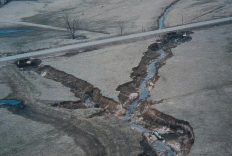
9 WEST PAPILLION CREEK, NEBRASKA 9

10 CANE CREEK, TENNESSEE 10


11 CHACO CANYON, NEW MEXICO 11

12 GULLY EROSION IN ETHIOPIA 12

13 CHANNEL ADJUSTMENT OVERVIEW 13
14 Channel Adjustment Longitudinal Long periods of time: Headwater erosion and downstream deposition Short periods of time: Local scour/deposition, degradation, and aggradation Interactions between discharge, sediment supply, and slope Lateral, streambank erosion Hydraulic: Fluvial erosion or entrainment Geotechnical: Mass wasting 14
15 Idealized Adjustment Trends For a given discharge (Q) 16
16 Adjustment: Boundary Shear Stress 18
17 Adjustment: Increasing Resistance 19
18 Idealized Adjustment Trends For a given discharge (Q) 20
19 Importance of Widening in Energy Dissipation Reduces flow depth (pressure head) for a given flow; Increases relative roughness, and therefore, Reduces flow velocity (kinetic energy); Combined with degradation (potential energy) is the most efficient means of energy reduction because all components of E are reduced; Counteracts increase in potential energy from aggradation 21
20 Width/Depth Changes During Adjustment 22
21 How Much Sediment Comes from Bank Failures? Widening rates of up to 100 m/yr Up to 90% of the sediment emanating from eroding channels Often, more than 50% of the sediment emanating from a watershed One 1-m failure along a 5-m high bank along a 100-m reach equals 400 metric tons or about 26 dump trucks 23

22 Little Blue River, Kansas ~ 631,000 tonnes eroded during 7 months About 42,000 dump trucks 24

23 STREAMBANK EROSION PROCESSES 25
24 Streambank Erosion I Hydraulic processes Erosive force applied by the flow exceeds the resisting force mobilized by the bank materials Resisting forces are different for cohesionless and cohesive materials: Cohesionless: grain size Cohesive: electrochemical bonding between soil particles 26
25 Streambank Erosion II Geotechnical processes Mass instability Gravitational force exceed resisting force Weight of soils vs. cohesion and friction Interplay between fluvial erosion and mass wasting Fluvial erosion may promote mass wasting Mass wasting may prevent fluvial erosion 27
26 Bank Retreat Processes Vertical face 28

27 Bank Retreat Processes Toe erosion steepens bank 29
28 Bank Retreat Processes Tension crack develops 30
29 Bank Retreat Processes Infiltration raises pore water pressure 31
30 Bank Retreat Processes Shearing starts 32
31 Bank Retreat Processes Bank failure occurs 33
32 Bank Retreat Processes Erosion removes the failed debris 34
33 Bank Retreat Processes Bank steepening starts again 35
34 Bank Retreat Processes Vertical face 36

35 37

36 Fluvial erosion 38

37 Applied force vs. resisting force Fluvial Erosion Applied drag force: boundary shear stress Near-bank flow field Discharge, flow depth, slope, channel form, secondary flow, turbulence, etc. Bank roughness Topographic variability, grain size, vegetation Resisting: Erosion resistance Grain size Cohesivity Water content Below-ground organics 39

38 Near-Bank Flow Field 40

39 Near-Bank Flow Field /w Roughness & Cover 41


40 Bank Shear Stress Estimation I Divided Channel Methods Vertical depth/area Normal depth/area Merged perpendicular method Can have significant error for more complex flow fields 42
41 Bank Shear Stress Estimation Ia 43
42 Bank Shear Stress Estimation III Simplified momentum equation Shiono & Knight method extended by Ervine 44
43 Bank Shear Stress Estimation IV 2D models 3D models 45

44 Cohesionless Bank Material Resistance & Transport Grain-size dependent Sediment transport dependent Cantelli and Parker (2004) 46
45 Cohesive Bank Material Resistance to Erosion Transport, deposition, and erosion of cohesive sediments are extremely complex Erosion resisting forces vary according to grain size and electrochemical bonding between particles Bonding is also affected by local history of soil development and antecedent soil moisture conditions Commonly it are aggregates that are eroded, disintegrating rapidly once entrained 48
 Weathering, cycles of wetting and drying can significantly increase erodibility Vegetation can increase erosion resistance by Binding the soil")
46 Cohesive Bank Material Resistance to Erosion (cont.) Weathering, cycles of wetting and drying can significantly increase erodibility Vegetation can increase erosion resistance by Binding the soil through their roots introducing an added cohesion Reducing pore-water pressures in the streambank 49
47 Cohesive Streambank Erosion Erosion rate is given by an excess shear stress relation Osman & Thorne (1988) Hanson & Simon (2001) Lateral erosion distance 50


48 Revised Erodibility Relation Thomas and Simon (2010) 51
49 Wynn et al. (2007) Variability in and 52

50 Mass wasting 53
51 Mass Failure Weight of the bank material exceeds the shear strength of the soil Often results of heightening and steepening of the bank Channel incision Toe erosion Depends on bank geometry and stratigraphy, soil water distribution, and riparian vegetation 54
52 Cohesionless vs Cohesive Mass Failures Cohesionless Dislodgement and avalanching of individual particles Shear failure along shallow slip surfaces Cohesive Deep-seated failures Block of disturbed soil sliding or toppling along a slip surface 55

53 Mass Failure Mechanisms I Rotational failure 56


54 Mass Failure Mechanisms II Planar failure 57

55 Mass Failure Mechanisms III Cantilever failure 58

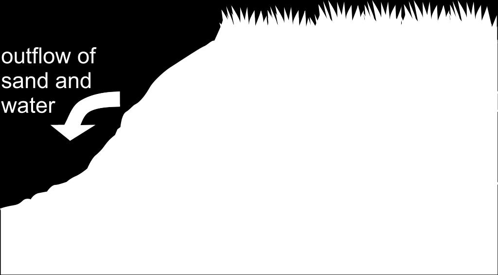
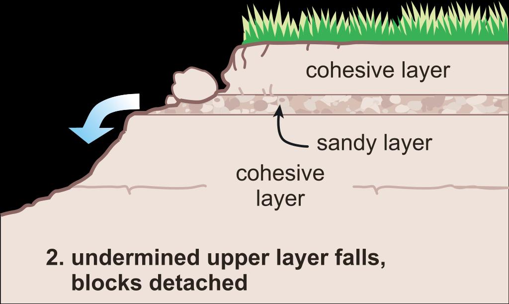
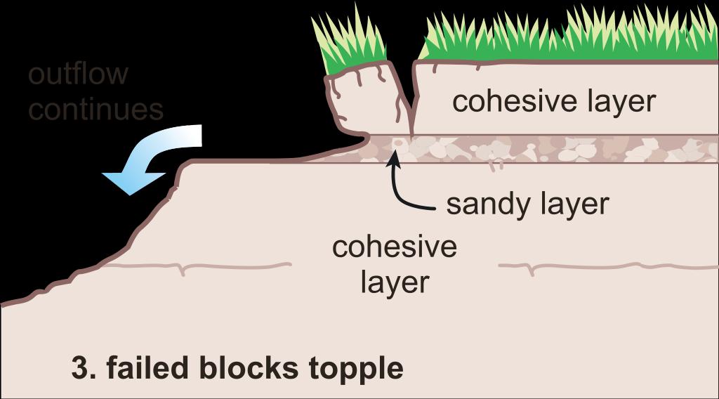
56 Mass Failure Mechanisms IV Seepage or sapping failure 59
57 Stability charts Planar Failure Analysis Early models, such as Osman & Thorne (1988), Simon et al. (1991), Darby and Thorne (1996), had limited capabilities Simplified bank profile Homogeneous bank material Slip surface angle prescribed Evaluation of pore-water effects Enhancements made in late 1990s and early 2000s (e.g., Rinaldi & Casagli, 1999; Simon et al., 2000) Matric suction Heterogeneous bank material 60

 S = mobilized shear force (N/m) W = weight of composite soil (N/m) β = angle of")
58 Streambank Stability Analysis Stability is analyzed using limit equilibrium methods => FOS Based upon static equilibriums of forces and/or moments Method of slices to account for: heterogeneous bank material Pore and confining pressures Fw = confining force (N/m) N = normal force (N/m) S = mobilized shear force (N/m) W = weight of composite soil (N/m) β = angle of slip surface 61


59 Streambank Stability Analysis Inclination of Failure Surface The inclination of the failure plane is that for which the factor of safety is a minimum CONCEPTS uses a search method to find smallest FOS Factor of safety is evaluated at Ne number of points along the bank profile 64
60 Shear failure Beam failure Cantilever Failure Analysis Tensile failure Thorne & Tovey (1981) 65


61 Fate of Failure Block Material Failed bank material may temporally protect the bank from further eroding Depends on: Failure type Soil properties Vegetation presence Hydraulics & hydrology 67
62 Failure Type Effects on Failure Block Fate Failure mode: Sliding Toppling Falling Location of failed material 68

63 Vegetation Effects 70
64 Vegetation Effects on Streambank Erosion Reduced erosion/width: Smith (1976): 20,000 times more resistance to erosion of vegetated soils Beeson and Doyle (1995): erosion 30 times more prevalent on non-vegetated bends Burckhardt and Todd (1998): unforested migration rate 3x larger Increased erosion/width: Davies-Colley (1997): increasing width from pasture to native to forested riparian zones. Trimble (1997): grassed reaches narrower than forested reaches 71
65 Vegetation Effects on Streambank Erosion (cont.) Resistance to surface erosion Resistance to failure Above ground biomass (stems and leaves) Below ground biomass (roots) Vegetation affects erosion through: Raindrop interception Increased infiltration and infiltration capacity Soil water transpiration Increased surface roughness Soil aggregate stability Soil reinforcement 72
66 Vegetation Effects on Streambank Stability Shear strength equation cohesion pore-water pressure Shear strength increases with increasing cohesion and decreasing pore-water pressure Vegetation affects both cohesion (i.e., soil bonding) and soil water content 73
67 Vegetation Effects on Streambank Stability (cont.) Mechanical Hydrologic Stabilizing Increased strength due to roots Transpiration and canopy interception Destabilizing Surcharge Increased infiltration rate and capacity 74

68 Mechanical Effects of Vegetation Root cohesion Two parameters: Root tensile strength Root-Area-Ratio Species-dependent Root tensile strength tester 75
69 Tensile strength, in MPa Root-Strength: Species Comparison Diameter, in mm 76


70 Map roots on frame and measure diameter with calipers Root Distribution Trench around suitable riparian trees, and date tree using dendochronology 77


71 Number of Roots vs Depth Black Willow Sweetgum River birch Sycamore Root size, mm 78


72 Root Area Ratio vs Depth Black Willow Sweetgum Root size, mm River birch Sycamore 79


73 Cohesion Due to Roots vs Depth Black Willow River birch Cohesion due to roots, kpa Cohesion due to roots, kpa Sweetgum Root size, mm Sycamore Cohesion due to roots, kpa Cohesion due to roots, kpa 80
74 Mechanical Findings Trees add 5-20 kpa cohesion to soil, over about cm depth (black willow least effective) Clump grasses add KPa cohesion Lots of small roots potentially provide greater strength than a few big roots However most of the strength from trees actually comes from large sized roots small roots make up too little area Significant strength achieved over 5-10 years growth 81
75 Quantifying the Hydrologic Effects of Vegetation Beneficial Effects: Increase in strength due to matric suction and reduced pore-water pressure Rainfall Interception Transpiration Detrimental Effects: Enhanced infiltration Enhanced permeability 82

76 Monitoring the Hydrologic Effects of Vegetation Rainfall, stemflow and throughfall monitored spatially and in real-time Pore-water pressure below plots monitored using tensiometers 83
77 Hydrology Findings 2% of rain is intercepted by riparian strip canopy (high intensity events, low canopy cover during winter/spring) Trees increase infiltration capacity, concentrating more water in upper cm soil than on bare or grasscovered banks Trees maintain suction at depth ( cm) into spring High matric suction at depth indicates deeper roots than found in survey (?) 84

78 Vegetation Effects on Streambank Stability (cont.) From Simon and Collison, ESPL,
79 Single bank BSTEM 1D models CONCEPTS HEC-RAS 2D models SRH-2D Telemac2D/Sisyphe RVR-Meander Assessment Tools

80 DATA NEEDS AND COLLECTION 87
81 Streambank Erosion Input Data Requirements Bank material properties Composition Unit weight Erodibility Shear strength Bank roughness Bank stability analysis options 88
82 Flume Methods to Determine Critical Device Annular flume Known flow conditions Field tests Shear Stress Bedload Depth range Armoring Erosion rate Shear stress range Yes No No m Yes No 0-1 Pa SEDFlume Yes Yes No 0-1 m No Yes 0-10 Pa SEDFlume /w trap channel Oscillatory flume Yes No Yes 0-1 m No Yes 0-10 Pa Yes Yes No 0-1 m Some Yes 0-10 Pa 89
83 In-Situ Jet Test Device to Determine Critical Shear Stress Developed by the Agricultural Research Service (Hanson, 1990). Based on knowledge of hydraulic characteristics of a submerged jet and the characteristics of soil-material erodibility. Apparatus: pump, adjustable head tank, jet submergence tank, jet nozzle, delivery tube, and point gage. The stress range = Pa. Maximum scour measurements are taken at five to ten minute intervals over a period of 60 to 120 minutes. 90
84 Closing remarks Bank erosion and channel width adjustment is common Channel width adjustment can be orders of magnitude greater than channel depth adjustment Bank erosion is controlled by fluvial and gravitational processes Bank erosion assessment is complex because of spatial variations in soil texture and the erosion mechanics of fine-grained soils
CONCEPTS Conservational Channel Evolution and Pollutant Transport System
 CONCEPTS Conservational Channel Evolution and Pollutant Transport System Eddy J. Langendoen Watershed Physical Processes Research Unit National Sedimentation Laboratory USDA Agricultural Research Service
Sensitivity Analysis of the Effective Parameters with Respect to Cantilever Type Failure in Composite Riverbanks
 Sensitivity Analysis of the Effective Parameters with Respect to Cantilever Type Failure in Composite Riverbanks A. Samadi 1, E. Amiri-Tokaldany 2, and M. H. Davoudi 3 1 Ph.D. Candidate, Department of
Analysis of Cost-Effective Rehabilitation: Principles and Tools for Reducing Uncertainty in Design
 Analysis of Cost-Effective Rehabilitation: Principles and Tools for Reducing Uncertainty in Design Natasha Bankhead and Andrew Simon Cardno ENTRIX, Oxford, MS natasha.bankhead@cardno.com Often the Questions
Erosion Rate is a Function of Erodibility and Excess Shear Stress = k ( o - c ) From Relation between Shear Stress and Erosion We Calculate c and
 From Relation between Shear Stress and Erosion We Calculate c and") Equilibrium, Shear Stress, Stream Power and Trends of Vertical Adjustment Andrew Simon USDA-ARS, Oxford, MS asimon@msa-oxford.ars.usda.gov Non-Cohesive versus Cohesive Materials Non-cohesive: sands and
Equilibrium, Shear Stress, Stream Power and Trends of Vertical Adjustment Andrew Simon USDA-ARS, Oxford, MS asimon@msa-oxford.ars.usda.gov Non-Cohesive versus Cohesive Materials Non-cohesive: sands and
Modelling riverbank retreat by combining reach-scale hydraulic models with bank-scale erosion and stability analyses
 River Flow 2010 - Dittrich, Koll, Aberle & Geisenhainer (eds) - 2010 Bundesanstalt für Wasserbau ISBN 978-3-939230-00-7 Modelling riverbank retreat by combining reach-scale hydraulic models with bank-scale
Goundwater Seepage Mechanisms of Streambank Erosion and Failure
 Goundwater Seepage Mechanisms of Streambank Erosion and Failure Taber L. Midgley M.S. Student Garey A. Fox Associate Professor Abdulsahib Al-Madhhachi Ph.D. Student Rachel Carson M.S. Student Biosystems
Overview of fluvial and geotechnical processes for TMDL assessment
 Overview of fluvial and geotechnical processes for TMDL assessment Christian F Lenhart, Assistant Prof, MSU Research Assoc., U of M Biosystems Engineering Fluvial processes in a glaciated landscape Martin
NATURE OF RIVERS B-1. Channel Function... ALLUVIAL FEATURES. ... to successfully carry sediment and water from the watershed. ...dissipate energy.
 1 2 Function... Sevier River... to successfully carry sediment and water from the watershed....dissipate energy. 3 ALLUVIAL FEATURES 4 CHANNEL DIMENSION The purpose of a stream is to carry water and sediment
Combined Vertical And Lateral Channel Evolution Numerical Modeling
 City University of New York (CUNY) CUNY Academic Works International Conference on Hydroinformatics 8-1-2014 Combined Vertical And Lateral Channel Evolution Numerical Modeling Yong G. Lai Kuowei Wu Follow
SCOPE OF PRESENTATION STREAM DYNAMICS, CHANNEL RESTORATION PLANS, & SEDIMENT TRANSPORT ANALYSES IN RELATION TO RESTORATION PLANS
 DESIGN METHODS B: SEDIMENT TRANSPORT PROCESSES FOR STREAM RESTORATION DESIGN PETER KLINGEMAN OREGON STATE UNIVERSITY CIVIL ENGINEERING DEPT., CORVALLIS 2 ND ANNUAL NORTHWEST STREAM RESTORATION DESIGN SYMPOSIUM
Aquifer an underground zone or layer of sand, gravel, or porous rock that is saturated with water.
 Aggradation raising of the streambed by deposition that occurs when the energy of the water flowing through a stream reach is insufficient to transport sediment conveyed from upstream. Alluvium a general
Each basin is surrounded & defined by a drainage divide (high point from which water flows away) Channel initiation
 Channel initiation") DRAINAGE BASINS A drainage basin or watershed is defined from a downstream point, working upstream, to include all of the hillslope & channel areas which drain to that point Each basin is surrounded &
DRAINAGE BASINS A drainage basin or watershed is defined from a downstream point, working upstream, to include all of the hillslope & channel areas which drain to that point Each basin is surrounded &
NUMERICAL SIMULATION OF A CANTILEVER FAILURE WITH THE EFFECT OF SLUMP BLOCKS FOR COHESIVE RIVERBANKS
 Annual Journal of Hydraulic Engineering, JSCE, Vol.60, 2016, February NUMERICAL SIMULATION OF A CANTILEVER FAILURE WITH THE EFFECT OF SLUMP BLOCKS FOR COHESIVE RIVERBANKS Supapap PATSINGHASANEE 1, Ichiro
Probabilistic Evaluation of a Meandering Low-Flow Channel. February 24 th, UMSRS
 Probabilistic Evaluation of a Meandering Low-Flow Channel February 24 th, 2014 2014 UMSRS 1 2 acknowledgments Low- Flow Channel (LFC) overview Proposed Diversion Channel collects runoff from: The Rush
River Embankment Failure due to Overtopping - In Case of Non-cohesive Sediment -
 Nov 4, 2014 2014 International Workshop on Typhoon and Flood River Embankment Failure due to Overtopping - In Case of Non-cohesive Sediment - Prof. Hajime NAKAGAWA Prof. of Disaster Prevention Research
MEANDER MIGRATION MODEL ASSESSMENT FOR THE JANUARY 2005 STORM, WHITMAN PROPERTY, SAN ANTONIO CREEK, VENTURA COUNTY, CALIFORNIA
 MEANDER MIGRATION MODEL ASSESSMENT FOR THE JANUARY 2005 STORM, WHITMAN PROPERTY, SAN ANTONIO CREEK, VENTURA COUNTY, CALIFORNIA Prepared by Eric Larsen, Ph.D. Mark Rains, Ph.D. October 2006 INTRODUCTION
ES 105 Surface Processes I. Hydrologic cycle A. Distribution % in oceans 2. >3% surface water a. +99% surface water in glaciers b.
 ES 105 Surface Processes I. Hydrologic cycle A. Distribution 1. +97% in oceans 2. >3% surface water a. +99% surface water in glaciers b. >1/3% liquid, fresh water in streams and lakes~1/10,000 of water
Using Weather and Climate Information for Landslide Prevention and Mitigation
 Using Weather and Climate Information for Landslide Prevention and Mitigation Professor Roy C. Sidle Disaster Prevention Research Institute Kyoto University, Japan International Workshop on Climate and
Rapid Geomorphic Assessments: RGA s
 Establishing Current Reference Conditions Rates and concentrations of suspended-sediment transport vary over time and space due to factors such as precipitation characteristics and discharge, geology,
Mass Wasting. Revisit: Erosion, Transportation, and Deposition
 Mass Wasting Revisit: Erosion, Transportation, and Deposition While landslides are a normal part of erosion and surface processes, they can be very destructive to life and property! - Mass wasting: downslope
Seepage erosion in layered stream bank material
 See discussions, stats, and author profiles for this publication at: https://www.researchgate.net/publication/230328845 Seepage erosion in layered stream bank material Article in Earth Surface Processes
This is a repository copy of Modeling of multilayer cohesive bank erosion with a coupled bank stability and mobile-bed model.
 This is a repository copy of Modeling of multilayer cohesive bank erosion with a coupled bank stability and mobile-bed model. White Rose Research Online URL for this paper: http://eprints.whiterose.ac.uk/87516/
3/3/2013. The hydro cycle water returns from the sea. All "toilet to tap." Introduction to Environmental Geology, 5e
 Introduction to Environmental Geology, 5e Running Water: summary in haiku form Edward A. Keller Chapter 9 Rivers and Flooding Lecture Presentation prepared by X. Mara Chen, Salisbury University The hydro
Stream Geomorphology. Leslie A. Morrissey UVM July 25, 2012
 Stream Geomorphology Leslie A. Morrissey UVM July 25, 2012 What Functions do Healthy Streams Provide? Flood mitigation Water supply Water quality Sediment storage and transport Habitat Recreation Transportation
Ways To Identify Background Verses Accelerated Erosion
 Ways To Identify Background Verses Accelerated Erosion Establish Background Condition From Old Ground Photos, Aerial Photos, and Maps Compare Rate Over Time At the Same Location, or for Reaches Channel
Dolores River Watershed Study
 CHAPTER 4: RIVER AND FLOODPLAIN ISSUES The Dolores River falls into a category of streams in Colorado that share some unique characteristics. Like some other mountain streams in the state, it has a steep
Prof. B V S Viswanadham, Department of Civil Engineering, IIT Bombay
 19 Module 5: Lecture -1 on Stability of Slopes Contents Stability analysis of a slope and finding critical slip surface; Sudden Draw down condition, effective stress and total stress analysis; Seismic
Sediment Sources, Baseline Sediment- Transport Rates and the Effectiveness of Restoration Measures for Reducing Loads to Receiving Waters
 Sediment Sources, Baseline Sediment- Transport Rates and the Effectiveness of Restoration Measures for Reducing Loads to Receiving Waters Andrew Simon Cardno, Oxford, MS, USA andrew.simon@cardno.com Not
Module 4: Overview of the Fundamentals of Runoff and Erosion
 Module 4: Overview of the Fundamentals of Runoff and Erosion Module 4a Goal Once we can better understand the forces which cause erosion and runoff, only then can we begin to minimize the negative results.
ADDRESSING GEOMORPHIC AND HYDRAULIC CONTROLS IN OFF-CHANNEL HABITAT DESIGN
 ADDRESSING GEOMORPHIC AND HYDRAULIC CONTROLS IN OFF-CHANNEL HABITAT DESIGN Conor Shea - Hydrologist U.S. Fish and Wildlife Service Conservation Partnerships Program Arcata, CA Learning Objectives Examine
Riparian Assessment. Steps in the right direction... Drainage Basin/Watershed: Start by Thinking Big. Riparian Assessment vs.
 Riparian Assessment vs. Monitoring Riparian Assessment What is a healthy stream? Determine stream/riparian health Determine change or trend, especially in response to mgmt Classification = designation
J. Paul Guyer, P.E., R.A.
 J. Paul Guyer, P.E., R.A. Paul Guyer is a registered mechanical engineer, civil engineer, fire protection engineer and architect with over 35 years experience in the design of buildings and related infrastructure.
Surface Processes Focus on Mass Wasting (Chapter 10)
") Surface Processes Focus on Mass Wasting (Chapter 10) 1. What is the distinction between weathering, mass wasting, and erosion? 2. What is the controlling force in mass wasting? What force provides resistance?
Surface Processes Focus on Mass Wasting (Chapter 10) 1. What is the distinction between weathering, mass wasting, and erosion? 2. What is the controlling force in mass wasting? What force provides resistance?
Development and testing of improved physically based streambank erosion and sediment routing routines in SWAT
 Development and testing of improved physically based streambank erosion and sediment routing routines in SWAT Balaji Narasimhan, P. M. Allen, Stephanie Capello, and Dave Coffman, J.G. Arnold, and R. Srinivasan
Upper Mississippi River Basin Environmental Management Program Workshop
 Presentation to the Upper Mississippi River Basin Environmental Management Program Workshop by Michael Rodgers River Engineer US Army Corps of Engineers, St. Louis District August 17, 2007 Engineering
KINEROS2/AGWA. Fig. 1. Schematic view (Woolhiser et al., 1990).
.") KINEROS2/AGWA Introduction Kineros2 (KINematic runoff and EROSion) (K2) model was originated at the USDA-ARS in late 1960s and released until 1990 (Smith et al., 1995; Woolhiser et al., 1990). The spatial
KINEROS2/AGWA Introduction Kineros2 (KINematic runoff and EROSion) (K2) model was originated at the USDA-ARS in late 1960s and released until 1990 (Smith et al., 1995; Woolhiser et al., 1990). The spatial
The effectiveness of check dams in controlling upstream channel stability in northeastern Taiwan
 Erosion, Debris Mows and Environment in Mountain Regions (Proceedings of the Chengdu Symposium, July 1992). IAHS Publ. no. 209, 1992. 423 The effectiveness of check dams in controlling upstream channel
Why Geomorphology for Fish Passage
 Channel Morphology - Stream Crossing Interactions An Overview Michael Love Michael Love & Associates mlove@h2odesigns.com (707) 476-8938 Why Geomorphology for Fish Passage 1. Understand the Scale of the
SPECIFIC DEGRADATION AND RESERVOIR SEDIMENTATION. By Renee Vandermause & Chun-Yao Yang
 SPECIFIC DEGRADATION AND RESERVOIR SEDIMENTATION By Renee Vandermause & Chun-Yao Yang Outline Sediment Degradation - Erosion vs Sediment Yield - Sediment Yield - Methods for estimation - Defining Sediment
Discussion of Response of a residual soil slope to rainfall 1
 979 DISCUSSION / DISCUSSION Discussion of Response of a residual soil slope to rainfall 1 Ana C. Londono Received 22 January 2006. Accepted 15 June 2006. Published on the NRC Research Press Web site at
Perspectives on river restoration science, geomorphic processes, and channel stability
 Perspectives on river restoration science, geomorphic processes, and channel stability Stream Restoration Forum: Science and Regulatory Connections Andrew C. Wilcox Department of Geosciences University
Why Stabilizing the Stream As-Is is Not Enough
 Why Stabilizing the Stream As-Is is Not Enough Several examples of alternatives to the County s design approach have been suggested. A common theme of these proposals is a less comprehensive effort focusing
Carmel River Bank Stabilization at Rancho San Carlos Road Project Description and Work Plan March 2018
 Carmel River Bank Stabilization at Rancho San Carlos Road Project Description and Work Plan March 2018 EXISTING CONDITION The proposed Carmel River Bank Stabilization at Rancho San Carlos Road Project
Slope Stability. loader
 Slope Stability Slope Stability loader Lower San Fernando Dam Failure, 1971 Outlines Introduction Definition of key terms Some types of slope failure Some causes of slope failure Shear Strength of Soils
Erosion Surface Water. moving, transporting, and depositing sediment.
 + Erosion Surface Water moving, transporting, and depositing sediment. + Surface Water 2 Water from rainfall can hit Earth s surface and do a number of things: Slowly soak into the ground: Infiltration
CASE STUDIES. Introduction
 Introduction The City of Winston-Salem faces the challenge of maintaining public infrastructure (e.g., water and sewer lines, storm drains, roads, culverts and bridges) while minimizing the potential impacts
Year 6. Geography. Revision
 Year 6 Geography Revision November 2017 Rivers and World knowledge How the water cycle works and the meaning of the terms evaporation, condensation, precipitation, transpiration, surface run-off, groundwater
Landscape Development
 Landscape Development Slopes Dominate Natural Landscapes Created by the interplay of tectonic and igneous activity and gradation Deformation and uplift Volcanic activity Agents of gradation Mass wasting
What Is Water Erosion? Aren t they the same thing? What Is Sediment? What Is Sedimentation? How can Sediment Yields be Minimized?
 Jerald S. Fifield, Ph.D. CISEC HydroDynamics Incorporated Parker, CO 303-841-0377 Aren t they the same thing? What Is Sediment? Soil particles deposited or suspended in water or air The process of depositing
GEOTECHNICAL ENGINEERING ECG 503 LECTURE NOTE ANALYSIS AND DESIGN OF RETAINING STRUCTURES
 GEOTECHNICAL ENGINEERING ECG 503 LECTURE NOTE 07 3.0 ANALYSIS AND DESIGN OF RETAINING STRUCTURES LEARNING OUTCOMES Learning outcomes: At the end of this lecture/week the students would be able to: Understand
Stability Analysis of Landslide Dam under Rainfall
 Stability Analysis of Landslide Dam under Rainfall Pei-Hsun Tsai, Zheng-Yi Feng 2, Fan-Chieh Yu 3 and Jian-Han Lin 4 Associate Professor, Department of Construction Engineering, Chaoyang University of
Consequences of river regulation works: altered fluvial processes + increasing flood hazard
 Consequences of river regulation works: altered fluvial processes + increasing flood hazard Dr. Tímea Kiss assistant professor Department of Physical Geography and Geoinformatics, University of Szeged,
MATHEMATICAL MODELING OF FLUVIAL SEDIMENT DELIVERY, NEKA RIVER, IRAN. S.E. Kermani H. Golmaee M.Z. Ahmadi
 JOURNAL OF ENVIRONMENTAL HYDROLOGY The Electronic Journal of the International Association for Environmental Hydrology On the World Wide Web at http://www.hydroweb.com VOLUME 16 2008 MATHEMATICAL MODELING
Application of the CONCEPTS Channel Evolution Model in Stream Restoration Strategies
 Application of the CONCEPTS Channel Evolution Model in Stream Restoration Strategies Eddy J. Langendoen National Sedimentation Laboratory, Agricultural Research Service, USDA, Oxford, Mississippi, USA
Running Water Earth - Chapter 16 Stan Hatfield Southwestern Illinois College
 Running Water Earth - Chapter 16 Stan Hatfield Southwestern Illinois College Hydrologic Cycle The hydrologic cycle is a summary of the circulation of Earth s water supply. Processes involved in the hydrologic
Modeling Post-Development Runoff and Channel Impacts from Hydromodification: Practical Tools for Hydromodification Assessment
 Modeling Post-Development Runoff and Channel Impacts from Hydromodification: Practical Tools for Hydromodification Assessment Chris Bowles, Ph.D. Andy Collison, Ph.D. Matt Wickland, M.S. c.bowles@pwa-ltd.com
Fluvial Geomorphology
 Geomorphic Components of Riparian Ecosystems W. Barry Southerland, Ph.D. Fluvial Geomorphologist, CPESC #514 West National Technology Support Center Water Quality and Quantity Technology Development Team
An Analytical Approach for Determination of Riverbank Erosion under Action of Capillary Cohesion, Viscous Force and Force due to Pore Pressure
 An Analytical Approach for Determination of Riverbank Erosion under Action of Capillary Cohesion, Viscous Force and Force due to Pore Pressure Sanchayan Mukherjee 1, Bimalendu Pal 2, Debasish Mandi 2,
Evaluation of the bank stability and toe erosion model (BSTEM) for predicting lateral retreat on composite streambanks
 for predicting lateral retreat on composite streambanks") University of Nebraska - Lincoln DigitalCommons@University of Nebraska - Lincoln Biological Systems Engineering: Papers and Publications Biological Systems Engineering 4-2012 Evaluation of the bank stability
University of Nebraska - Lincoln DigitalCommons@University of Nebraska - Lincoln Biological Systems Engineering: Papers and Publications Biological Systems Engineering 4-2012 Evaluation of the bank stability
Streambank Erosion and Instability Induced by Groundwater Seepage
 University of Nebraska - Lincoln DigitalCommons@University of Nebraska - Lincoln Biological Systems Engineering: Papers and Publications Biological Systems Engineering 8-2011 Streambank Erosion and Instability
Mass Movements and Hillslopes
 Mass Movements and Hillslopes Erosion (or lack of) results from balance between internal resistance of materials & magnitude of external forces acting on them Evolution of landscapes depends largely on
Hydraulics of bendway weirs
 River Basin Management IV 389 Hydraulics of bendway weirs C. Thornton 1, S. Abt 1, D. Baird 2 & R. Padilla 3 1 Colorado State University, Fort Collins, CO, USA 2 U.S. Bureau of Reclamation, Denver, CO,
Hydraulics Prof. Dr. Arup Kumar Sarma Department of Civil Engineering Indian Institute of Technology, Guwahati
 Hydraulics Prof. Dr. Arup Kumar Sarma Department of Civil Engineering Indian Institute of Technology, Guwahati Module No. # 04 Gradually Varied Flow Lecture No. # 07 Rapidly Varied Flow: Hydraulic Jump
Predicting Erosion Rates of Cohesive Streambanks
 Predicting Erosion Rates of Cohesive Streambanks * Donovan M, A Miller, M Baker, A Gellis. 2015. Sediment contributions from floodplains and legacy sediments to Piedmont streams of Baltimore County, Maryland.
[1] Performance of the sediment trap depends on the type of outlet structure and the settling pond surface area.
![[1] Performance of the sediment trap depends on the type of outlet structure and the settling pond surface area.](/thumbs/76/74245181.jpg "[1] Performance of the sediment trap depends on the type of outlet structure and the settling pond surface area.") Sediment Trench SEDIMENT CONTROL TECHNIQUE Type 1 System Sheet Flow Sandy Soils Type 2 System [1] Concentrated Flow Clayey Soils Type 3 System [1] Supplementary Trap Dispersive Soils [1] Performance of
Sediment Trench SEDIMENT CONTROL TECHNIQUE Type 1 System Sheet Flow Sandy Soils Type 2 System [1] Concentrated Flow Clayey Soils Type 3 System [1] Supplementary Trap Dispersive Soils [1] Performance of
Watershed concepts for community environmental planning
 Purpose and Objectives Watershed concepts for community environmental planning Dale Bruns, Wilkes University USDA Rural GIS Consortium May 2007 Provide background on basic concepts in watershed, stream,
JOHN REDMOND RESERVOIR
 JOHN REDMOND RESERVOIR STREAMBANK STABILIZATION Hybrid Stream Solutions Leslie Ogar, Emelia Brooks, and Lizzie Hickman Prepared for the USACE Tulsa Office 5 December 2014 OUTLINE Introduction Technical
Slope Stability Model of the Questa Rock Pile Phase 2
 2 Proceedings Tailings and Mine Waste 2011 Slope Stability Model of the Questa Rock Pile Phase 2 Murray Fredlund SoilVision Systems Ltd., Saskatoon, Canada Haihua Lu SoilVision Systems Ltd., Saskatoon,
Vegetation effects on river hydraulics. Johannes J. (Joe) DeVries David Ford Consulting Engineers, Inc. Sacramento, CA
 DeVries David Ford Consulting Engineers, Inc. Sacramento, CA") Vegetation effects on river hydraulics Johannes J. (Joe) DeVries David Ford Consulting Engineers, Inc. Sacramento, CA jjdevries@ford-consulting.com SAC05 D2P31 RM 99.0L VIEW UPSTREAM AT UPSTREAM END DWR
Vegetation effects on river hydraulics Johannes J. (Joe) DeVries David Ford Consulting Engineers, Inc. Sacramento, CA jjdevries@ford-consulting.com SAC05 D2P31 RM 99.0L VIEW UPSTREAM AT UPSTREAM END DWR
mountain rivers fixed channel boundaries (bedrock banks and bed) high transport capacity low storage input output
 high transport capacity low storage input output") mountain rivers fixed channel boundaries (bedrock banks and bed) high transport capacity low storage input output strong interaction between streams & hillslopes Sediment Budgets for Mountain Rivers Little
mountain rivers fixed channel boundaries (bedrock banks and bed) high transport capacity low storage input output strong interaction between streams & hillslopes Sediment Budgets for Mountain Rivers Little
Improved physically based approaches for Channel Erosion Modeling in SWAT. Balaji Narasimhan, P. M. Allen, J. G. Arnold, and R.
 Improved physically based approaches for Channel Erosion Modeling in SWAT Balaji Narasimhan, P. M. Allen, J. G. Arnold, and R. Srinivasan Outline Channel Erosion Sediment Routing In SWAT2000 and SWAT2005
HAW CREEK, PIKE COUNTY, MISSOURI-TRIB TO SALT RIVER ERODING STREAM THREATHENING COUNTY ROAD #107, FOURTEEN FT TALL ERODING BANK WITHIN 4 FT OF THE
 HAW CREEK, PIKE COUNTY, MISSOURI-TRIB TO SALT RIVER ERODING STREAM THREATHENING COUNTY ROAD #107, FOURTEEN FT TALL ERODING BANK WITHIN 4 FT OF THE ROAD, PROJECT CONSTRUCTED IN 1 DAY, MARCH 10, 2009 BY
The Sandbox Project 1 cm 10 m
 The Sandbox Project 1 cm 10 m SETUP: 5 lbs of fine sand Funnel 1 measuring grid (22 by 22) adjustable hinterland height outflow pipe trash barrel ½ foam + plastic liner 63-μm sieve (sediment trap) Modeling
Modelling of flow and sediment transport in rivers and freshwater deltas Peggy Zinke
 1 Modelling of flow and sediment transport in rivers and freshwater deltas Peggy Zinke with contributions from Norwegian and international project partners 2 Outline 1. Introduction 2. Basic ideas of flow
 Rock Slope Analysis Small and Large Scale Failures Mode of Failure Marklands Test To establish the possibility of wedge failure. Plane failure is a special case of wedge failure. Sliding along
Do you think sediment transport is a concern?
 STREAM RESTORATION FRAMEWORK AND SEDIMENT TRANSPORT BASICS Pete Klingeman 1 What is Your Restoration Project Like? k? Do you think sediment transport is a concern? East Fork Lewis River, WA Tidal creek,
Watershed Conservation Management Planning Using the Integrated Field & Channel Technology of AnnAGNPS & CONCEPTS
 Watershed Conservation Management Planning Using the Integrated Field & Channel Technology of AnnAGNPS & CONCEPTS Eddy Langendoen Ron Bingner USDA-ARS National Sedimentation Laboratory, Oxford, Mississippi
VARIATION OF MANNING S ROUGHNESS COEFFICIENT WITH SEEPAGE IN SAND-BED CHANNEL *Satish Patel 1 and Bimlesh Kumar 2
 International Journal of Science, Environment and Technology, Vol. 5, No 6, 2016, 3678 3685 ISSN 2278-3687 (O) 2277-663X (P) VARIATION OF MANNING S ROUGHNESS COEFFICIENT WITH SEEPAGE IN SAND-BED CHANNEL
16 Rainfall on a Slope
 Rainfall on a Slope 16-1 16 Rainfall on a Slope 16.1 Problem Statement In this example, the stability of a generic slope is analyzed for two successive rainfall events of increasing intensity and decreasing
GEOL 1121 Earth Processes and Environments
 GEOL 1121 Earth Processes and Environments Wondwosen Seyoum Department of Geology University of Georgia e-mail: seyoum@uga.edu G/G Bldg., Rm. No. 122 Seyoum, 2015 Chapter 6 Streams and Flooding Seyoum,
Working with Natural Stream Systems
 Working with Natural Stream Systems Graydon Dutcher Delaware County Soil & Water Conservation District Stream Corridor Management Program Tropical Storm Sandy October 29,2012 What is a Watershed?
11/12/2014. Running Water. Introduction. Water on Earth. The Hydrologic Cycle. Fluid Flow
 Introduction Mercury, Venus, Earth and Mars share a similar history, but Earth is the only terrestrial planet with abundant water! Mercury is too small and hot Venus has a runaway green house effect so
GEOSYNTHETICS ENGINEERING: IN THEORY AND PRACTICE
 GEOSYNTHETICS ENGINEERING: IN THEORY AND PRACTICE Prof. J. N. Mandal Department of civil engineering, IIT Bombay, Powai, Mumbai 400076, India. Tel.022-25767328 email: cejnm@civil.iitb.ac.in Module - 4
Foundation Analysis LATERAL EARTH PRESSURE
 Foundation Analysis LATERAL EARTH PRESSURE INTRODUCTION Vertical or near-vertical slopes of soil are supported by retaining walls, cantilever sheet-pile walls, sheet-pile bulkheads, braced cuts, and other
Introduction to Soil Mechanics
 Introduction to Soil Mechanics Sela Sode and Colin Jones WILEY Blackwell Contents Preface Dedication and Acknowledgments List of Symbols Soil Structure 1.1 Volume relationships 1.1.1 Voids ratio (e) 1.1.2
NATURAL RIVER. Karima Attia Nile Research Institute
 NATURAL RIVER CHARACTERISTICS Karima Attia Nile Research Institute NATURAL RIVER DEFINITION NATURAL RIVER DEFINITION Is natural stream of water that flows in channels with ih more or less defined banks.
Sediment Transport Analysis for Stream Restoration Design: The Good, the Bad, and the Ugly.
 Sediment Transport Analysis for Stream Restoration Design: The Good, the Bad, and the Ugly. Brett Jordan Phd, PE HydroGeo Designs LLC. Land and Water Services Inc. THE GOOD THE BAD THE UGLY THE GOOD THE
UGRC 144 Science and Technology in Our Lives/Geohazards
 UGRC 144 Science and Technology in Our Lives/Geohazards Flood and Flood Hazards Dr. Patrick Asamoah Sakyi Department of Earth Science, UG, Legon College of Education School of Continuing and Distance Education
Dams, sediment, and channel changes and why you should care
 Dams, sediment, and channel changes and why you should care Gordon E. Grant USDA Forest Service PNW Research Station Corvallis, Oregon Dam effects on river regimes FLOW (Q) SEDIMENT (Qs) TEMP CHEMISTRY
Fluvial Geomorphic Guidelines
 Fluvial Geomorphic Guidelines FACT SHEET I: GEOMORPHOLOGICAL HAZARDS CONFINED AND UNCONFINED WATERCOURSES Channel migration and erosion can create substantial risk to inappropriately located infrastructure
Climate effects on landslides
 GEORAMP ONE DAY SYMPOSIUM Climate effects on landslides E. E. Alonso, M. Sondón, N. M. Pinyol Universitat Politècnica de Catalunya October 14th, 2016. UPC, Barcelona Infiltration (evaporation) and slope
Rivers T. Perron
 1 Rivers T. Perron 12.001 After our discussions of large-scale topography, how we represent topography in maps, and how topography interacts with geologic structures, you should be frothing at the mouth
Swift Creek Sediment Management Action Plan (SCSMAP)
") Swift Creek Sediment Management Action Plan (SCSMAP) PHASE 2 PROJECT PLAN PROPOSAL Whatcom County Public Works Department 322 N. Commercial Street, Suite 210 Bellingham, WA 98225 (360) 676-6692 June 2013
Swift Creek Sediment Management Action Plan (SCSMAP) PHASE 2 PROJECT PLAN PROPOSAL Whatcom County Public Works Department 322 N. Commercial Street, Suite 210 Bellingham, WA 98225 (360) 676-6692 June 2013
Illinois State Water Survey Division
 Illinois State Water Survey Division SURFACE WATER SECTION SWS Miscellaneous Publication 108 SEDIMENT YIELD AND ACCUMULATION IN THE LOWER CACHE RIVER by Misganaw Demissie Champaign, Illinois June 1989
EXPERIMENT OF CHANNELIZATION DUE TO SEEPAGE EROSION
 Geotec., Const. Mat. & Env., DOI: https://doi.org/.26/8.46.wre4 ISSN: 286-2982 (Print), 286-299 (Online), Japan EXPERIMENT OF CHANNELIZATION DUE TO SEEPAGE EROSION Wandee Thaisiam, Peerapon Kaewnon and
How Do Human Impacts and Geomorphological Responses Vary with Spatial Scale in the Streams and Rivers of the Illinois Basin?
 How Do Human Impacts and Geomorphological Responses Vary with Spatial Scale in the Streams and Rivers of the Illinois Basin? Bruce Rhoads Department of Geography University of Illinois at Urbana-Champaign
Avoiding Geohazards in the Mid-Atlantic Highlands by Using Natural Stream Principles
 Avoiding Geohazards in the Mid-Atlantic Highlands by Using Natural Stream Principles J. Steven Kite, WVU Neal Carte, WVDOT Will Harman, Michael Baker Corp. Donald D. Gray, WVU Photo: W. Gillespie North
Conceptual Model of Stream Flow Processes for the Russian River Watershed. Chris Farrar
 Conceptual Model of Stream Flow Processes for the Russian River Watershed Chris Farrar Several features of creeks affect the interactions between surface and groundwater. This conceptual model uses the
The Long Profile Characteristics. Why does a river meander in its middle and lower course?
 QU: How are Meanders formed? AIM: To describe and explain meander formation and identify the difference between GCSE and A/S knowledge and expectations. ST: Get the key rivers terms from the pictures.
CONTROLLING FACTORS BASIC ISSUES SAFETY IN OPENCAST MINING WITH SPECIAL REFERENCE TO SLOPE STABILITY
 SAFETY IN OPENCAST MINING WITH SPECIAL REFERENCE TO SLOPE STABILITY CONTROLLING FACTORS Dr. J C. JHANWAR Sr. Principal Scientist CSIR-Central Institute of Mining & Fuel Research Regional Centre, Nagpur