Development and testing of improved physically based streambank erosion and sediment routing routines in SWAT
|
|
|
- Dinah Watkins
- 5 years ago
- Views:
Transcription
1 Development and testing of improved physically based streambank erosion and sediment routing routines in SWAT Balaji Narasimhan, P. M. Allen, Stephanie Capello, and Dave Coffman, J.G. Arnold, and R. Srinivasan
2 Outline Channel Erosion Sediment Routing In SWAT2000 and SWAT2005 Physically based approach Erosion Transportation Deposition Field monitoring and model results

3 Channel Erosion Channel erosion Can account for as much as 85% of total sediment yield of a watershed Predicted loss in 3 km channel erosion = 1000 years of sheet and rill erosion at preconservation agriculture rates
4 Channel Erosion Three major processes Subaerial processes Climate Alternate wet and dry cycles Freeze/Thaw cycles Cracking Fluvial erosion (Hydraulic Erosion) Removal of particles by streamflow Bank Failure Caused due to slope instability
5 SWAT2000 and 2005 Simplified Bagnold stream power equation conc sed, mx spcon v sp ch exp sed ) V deg Channel erosion ( conc sed, mx conc sed, ch limited only by the stream power or transport capacity but not by limits on sediment supply from the actual erosion process ch K ch C ch
6 SWAT2000 and 2005 No particle size distribution of eroded sediment No bedload Hence, TSS calculated from sediment yield is often high and not directly comparable with observations
7 Organic nutrient load Are we missing to quantify a significant organic nutrient load from stream bank and attributing the nutrient loads only to overland? Cedar Creek, Texas 8% of orgn and 15% of orgp from channel erosion Channel erosion 35% of total sediment yield Hence, accurate quantification of channel erosion is very important
8

9 Complex Process: Simplify Soil Zone Slake Zone Bed Load Rock Zone
10 Fluvial Erosion Process For the erosion to occur There should be enough shear stress exerted by the flowing water on stream bank and stream bed to dislodge the sediments The channel should have enough stream power to carry the eroded sediments (overland+channel) Deposition will occur if the sediment transport capacity is low
11 Wash-load particle size distribution Sediment yield from overland (MUSLE) is partitioned using the approach used in CREAMS

12 Stream bank/bed erosion load particle distribution Channel bank and bed D50
13 Shear Stress Critical shear stress (τ c ) Soil parameter that governs erosion Erosion based on excess shear stress: a bank kd, ( ) 10 bank e, bank e, bed c, bank c, bed where ξ erosion rates of the bank and bed (m/s), k d erodibility coefficient of bank and bed (cm 3 /N-s) and τ c Critical shear stress acting on bank and bed (N/m 2 ). 6 a bed kd, ( ) 10 bed 6
14 Critical Shear Stress and Erodibility Coefficient Submerged Jet Test (Hanson and Cook, 1997; Hanson and Simon, 2001) Erodibility calculated as a function of jet index J i Jet index (depth of scour hole made by the jet per unit time Hanson and Simon, 2001 I w Plasticity Index

15 Empirical Equation for τ c Range mostly between: 0 and 100 N/m 2 But could go as High as 400 N/m 2 Julian and Torres, 2001
16 Shear Stress Effective shear stress based on channel hydraulics: (Eaton and Millar, 2004) e, bank SFbank ( W Pbed ) sin depth slpch depth w e, bed depth slp ch 1 SF bank 100 W 2 P bed 0.5 log SF bank log P P bed bank
17 Empirical Equation for K d Erodibility Coefficient, K d : (Temple and Hanson, 1994; Zhu et al. 2006) K M C d e exp ( s 1) 9.8 D 3 ( s 1) C 4.14( Clay%) M e Where s is relative density of sediment Range mostly between 0 and 0.01 cm 3 /N-s but could go As high as 3.75 cm 3 /N-s for highly erodible material
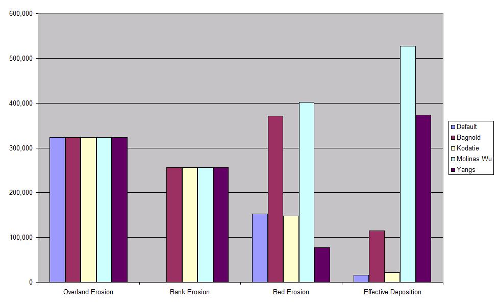
18 Stream Power/Transport Capacity Four new transport equations Simplified Bagnold Equation Silt type bed material conc sed, mx spcon v sp ch exp Kodatie model Silt to gravel size bed materials Molinas and Wu model Large sand bed rivers Yangs sand and gravel model Sand and gravel bed material
19 Kodatie Model Kodatie (2000) conc sed, ch. mx a b ch Q in y c S d W W 2 btm a, b, c and d coefficients depend on D 50
20 Molinas and Wu Model Molinas and Wu (2001): C w v 3 ch depth ( S 1) 50 log g g depth 10 D D conc sed, ch. mx C w C w (1 C w ) S g S g
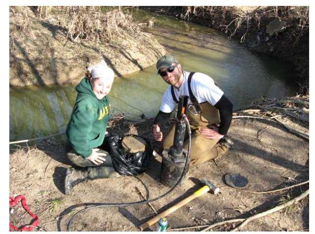
21 Yangs Sand and Gravel Model Sand equation: (D 50 less than 2mm): log C w 50D log 50D log 50 chs log 50 Vcr S Gravel equation: (D 50 between 2mm and 10mm) log C w 50D log 50D log V* log V* log V* log V* log chs log 50 Vcr S 50 50
22 Selecting the appropriate model Model Gravel Sand Very Fine sand and silt Bagnold X X Kodatie X X X Molinas and Wu X Yangs X X
23 Deposition If the sediment concentration in the channel is more than the transport capacity then deposition occurs: Einstein equation (1965): Dep x fract 1 1 x e Lch v depth Flood plain deposition ch If the streamflow goes overbank D
24 Excess transport capacity SedEx Vch conc sed, ch. mx conc sed, ch. i Excess sediment beyond transport capacity is also deposited But the channel is eroded only based on excess shear stress and not the available transport capacity Bank scour always occurs when excess shear stress is available Bed scour occurs only after all the deposited bed materials are scoured
25


26 Study Area Kings Creek Watershed
27
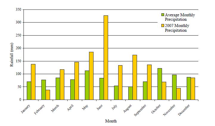
28 Field Data Collection Stage height Erosion rate (mm/event) Channel dimension Particle size distribution Submerged jet test Erodibility Period: 2007
29
30

31 Flow Calibration ( )
32

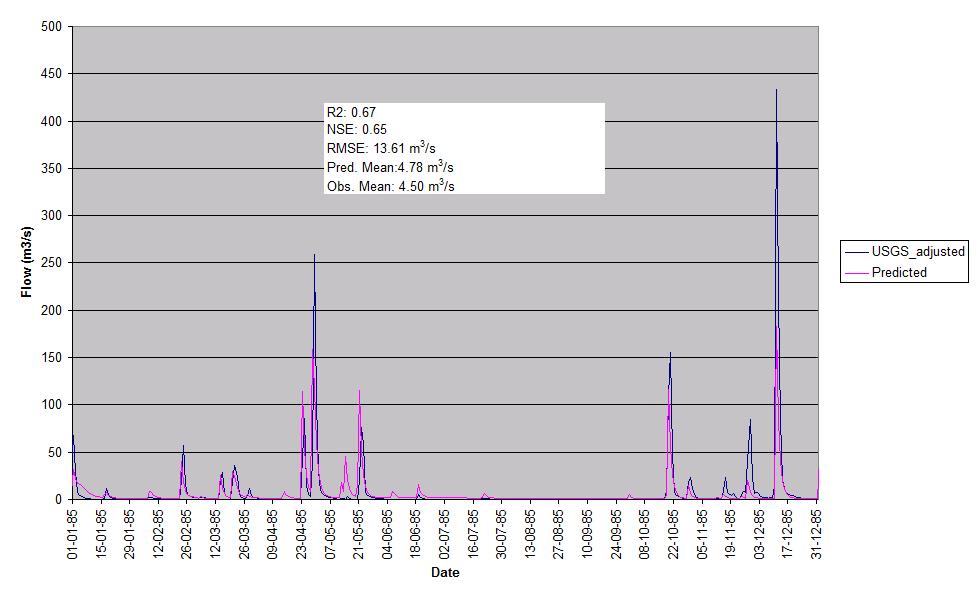
33 Flow Validation (2007)

34
35
36
37
38
39 Model Inputs Default model spcon, spexp, CH_cov, CH_Erod Physically based models D50 Median particle size of bank and bed material Cover factor of bank and bed Critical shear stress of bank and bed If not given, calculated based on SC% and cover Erodibility coefficient of bank and bed If not given, calculated based on SC% Bulk density of bank and bed If not given, calculated based on SC% Particle size distribution of bank and bed material Assumed based on the D50 size
40 Model Output File name: output.sed Default Total sediment Bed erosion, deposition, TSS Physically based models Total sediment Sand, silt, clay, SAGG, LAGG, gravel Bank erosion Bed erosion Channel deposition / Flood plain deposition Total remaining in deposits at the end of the time step TSS Only based on silt and clay particles
41 Conclusion Already most of the code is available in the present release Few changes are being made to represent the mass balance in a better way Detailed calibration and validation study is underway to evaluate the new routines New Components Active channel eroding length based on channel sinuosity Effect of alternate wetting and drying on erodibility
42 Thank You
Improved physically based approaches for Channel Erosion Modeling in SWAT. Balaji Narasimhan, P. M. Allen, J. G. Arnold, and R.
 Improved physically based approaches for Channel Erosion Modeling in SWAT Balaji Narasimhan, P. M. Allen, J. G. Arnold, and R. Srinivasan Outline Channel Erosion Sediment Routing In SWAT2000 and SWAT2005
SWAT INPUT DATA:.RTE CHAPTER 25
 CHAPTER 25 SWAT INPUT DATA:.RTE In order to simulate the physical processes affecting the flow of water and transport of sediment in the channel network of the watershed, SWAT requires information on the
Overview of fluvial and geotechnical processes for TMDL assessment
 Overview of fluvial and geotechnical processes for TMDL assessment Christian F Lenhart, Assistant Prof, MSU Research Assoc., U of M Biosystems Engineering Fluvial processes in a glaciated landscape Martin
The Importance of Riparian Vegetation in Channel Restoration: Moving Towards Quantification in Design
 The Importance of Riparian Vegetation in Channel Restoration: Moving Towards Quantification in Design Rob Millar Department of Civil Engineering The University of British Columbia "Nothing is as practical
Erosion Rate is a Function of Erodibility and Excess Shear Stress = k ( o - c ) From Relation between Shear Stress and Erosion We Calculate c and
 From Relation between Shear Stress and Erosion We Calculate c and") Equilibrium, Shear Stress, Stream Power and Trends of Vertical Adjustment Andrew Simon USDA-ARS, Oxford, MS asimon@msa-oxford.ars.usda.gov Non-Cohesive versus Cohesive Materials Non-cohesive: sands and
Equilibrium, Shear Stress, Stream Power and Trends of Vertical Adjustment Andrew Simon USDA-ARS, Oxford, MS asimon@msa-oxford.ars.usda.gov Non-Cohesive versus Cohesive Materials Non-cohesive: sands and
Evaluation of the two stage ditch as a best management practice. A. Hodaj, L.C. Bowling, C. Raj, I. Chaubey
 Evaluation of the two stage ditch as a best management practice A. Hodaj, L.C. Bowling, C. Raj, I. Chaubey Two-stage ditch: Stage 1 : main channel Stage 2 : flood plain bench Traditional ditch Twostage
Stream Entrainment, Erosion, Transportation & Deposition
 Lecture 12 Zone 2 of the Fluvial System, Continued Stream Entrainment, Erosion, Transportation & Deposition Erosion in a Fluvial Landscape Corrosion Chemical Erosion Corrasion Mechanical Weathering Cavitation
Do you think sediment transport is a concern?
 STREAM RESTORATION FRAMEWORK AND SEDIMENT TRANSPORT BASICS Pete Klingeman 1 What is Your Restoration Project Like? k? Do you think sediment transport is a concern? East Fork Lewis River, WA Tidal creek,
Integration of TUSLE in SWAT model for sediment prediction at a small mountainous catchment,chenyulan watershed,taiwan
 Integration of TUSLE in SWAT model for sediment prediction at a small mountainous catchment,chenyulan watershed,taiwan Presenter : Chih-Mei Lu Authors : Chih-Mei Lu, Li-Chi Chiang * Department of Civil
CONCEPTS Conservational Channel Evolution and Pollutant Transport System
 CONCEPTS Conservational Channel Evolution and Pollutant Transport System Eddy J. Langendoen Watershed Physical Processes Research Unit National Sedimentation Laboratory USDA Agricultural Research Service
(3) Sediment Movement Classes of sediment transported
 Sediment Movement Classes of sediment transported") (3) Sediment Movement Classes of sediment transported Dissolved load Suspended (and wash load ) Important for scouring algae Bedload (5-10% total load Moves along bed during floods Source of crushing for
(3) Sediment Movement Classes of sediment transported Dissolved load Suspended (and wash load ) Important for scouring algae Bedload (5-10% total load Moves along bed during floods Source of crushing for
Great Lakes Tributary Modeling: Canaseraga Creek Watershed
 Great Lakes Tributary Modeling: Canaseraga Creek Watershed SWAT Model Authority: Section 516(e) of WRDA 1996 US Army Corps of Engineers Canaseraga Creek Project Location - Encompasses portions of Livingston,
Quantifying Streambank Erosion and Phosphorus Load for Watershed Assessment and Planning
 Quantifying Streambank Erosion and Phosphorus Load for Watershed Assessment and Planning Daniel E. Storm, Professor, Room 121 Ag Hall, Stillwater, OK 74078, 405-762-1510, dan.storm@okstate.edu, Oklahoma
Goundwater Seepage Mechanisms of Streambank Erosion and Failure
 Goundwater Seepage Mechanisms of Streambank Erosion and Failure Taber L. Midgley M.S. Student Garey A. Fox Associate Professor Abdulsahib Al-Madhhachi Ph.D. Student Rachel Carson M.S. Student Biosystems
Why Stabilizing the Stream As-Is is Not Enough
 Why Stabilizing the Stream As-Is is Not Enough Several examples of alternatives to the County s design approach have been suggested. A common theme of these proposals is a less comprehensive effort focusing
Ways To Identify Background Verses Accelerated Erosion
 Ways To Identify Background Verses Accelerated Erosion Establish Background Condition From Old Ground Photos, Aerial Photos, and Maps Compare Rate Over Time At the Same Location, or for Reaches Channel
Sediment transport and river bed evolution
 1 Chapter 1 Sediment transport and river bed evolution 1.1 What is the sediment transport? What is the river bed evolution? System of the interaction between flow and river beds Rivers transport a variety
Analysis of Cost-Effective Rehabilitation: Principles and Tools for Reducing Uncertainty in Design
 Analysis of Cost-Effective Rehabilitation: Principles and Tools for Reducing Uncertainty in Design Natasha Bankhead and Andrew Simon Cardno ENTRIX, Oxford, MS natasha.bankhead@cardno.com Often the Questions
Sediment and Erosion Design Guide
 Sediment and Erosion Design Guide Sediment Transport & Bulking Factors Goals of this Session Review key principals Review basic relationships and available tools Review bulking factor relationships Purposes
(3) Sediment Movement Classes of sediment transported
 Sediment Movement Classes of sediment transported") 9/17/15 (3) Sediment Movement Classes of sediment transported Dissolved load Suspended load Important for scouring algae Bedload (5-10% total load) Moves along bed during floods Source of crushing for
9/17/15 (3) Sediment Movement Classes of sediment transported Dissolved load Suspended load Important for scouring algae Bedload (5-10% total load) Moves along bed during floods Source of crushing for
Watershed Assessment of River Stability and Sediment Supply: Advancing the Science of Watershed Analysis
 Watershed Assessment of River Stability and Sediment Supply: Advancing the Science of Watershed Analysis 2009 MWEA Annual Conference Rob Myllyoja, CET rmyllyoja@hrc-engr.com Watershed Assessment of River
A. V T = 1 B. Ms = 1 C. Vs = 1 D. Vv = 1
 Geology and Soil Mechanics 55401 /1A (2002-2003) Mark the best answer on the multiple choice answer sheet. 1. Soil mechanics is the application of hydraulics, geology and mechanics to problems relating
Geology and Soil Mechanics /1A ( ) Mark the best answer on the multiple choice answer sheet.
 Mark the best answer on the multiple choice answer sheet.") Geology and Soil Mechanics 55401 /1A (2003-2004) Mark the best answer on the multiple choice answer sheet. 1. Soil mechanics is the application of hydraulics, geology and mechanics to problems relating
Geology and Soil Mechanics 55401 /1A (2003-2004) Mark the best answer on the multiple choice answer sheet. 1. Soil mechanics is the application of hydraulics, geology and mechanics to problems relating
Modeling of a River Basin Using SWAT Model and SUFI-2
 Modeling of a River Basin Using SWAT Model and SUFI-2 NINA OMANI MASOUD TAJRISHY AHMAD ABRISHAMCHI Sharif University of Technology, Tehran, Iran Karkheh Dam, Iran 1 Area of Gharasu Sub-basin : 5793 km2
BED LOAD SEDIMENT TRANSPORT
 BED LOAD SEDIMENT TRANSPORT Kamal EL KADI ABDERREZZAK EDF-R&D, Laboratoire National d Hydraulique et Environnement (LNHE) 1 17-19 September 2009 UNL, Santa Fe, Argentina OUTLINE I. Bed load II. Settling
Rivers T. Perron
 1 Rivers T. Perron 12.001 After our discussions of large-scale topography, how we represent topography in maps, and how topography interacts with geologic structures, you should be frothing at the mouth
Modeling Upland and Channel Sources of Sediment in the Le Sueur River Watershed, Minnesota
 Modeling Upland and Channel Sources of Sediment in the Le Sueur River Watershed, Minnesota Solomon Folle and David Mulla Department of Soil, Water and Climate University of Minnesota August 6, 2009 5 th
SCOPE OF PRESENTATION STREAM DYNAMICS, CHANNEL RESTORATION PLANS, & SEDIMENT TRANSPORT ANALYSES IN RELATION TO RESTORATION PLANS
 DESIGN METHODS B: SEDIMENT TRANSPORT PROCESSES FOR STREAM RESTORATION DESIGN PETER KLINGEMAN OREGON STATE UNIVERSITY CIVIL ENGINEERING DEPT., CORVALLIS 2 ND ANNUAL NORTHWEST STREAM RESTORATION DESIGN SYMPOSIUM
HEC-RAS Reservoir Transport Simulation of Three Reservoirs in the Lower Susquehanna River Basin. Mike Langland and Ed Koerkle
 HEC-RAS Reservoir Transport Simulation of Three Reservoirs in the Lower Susquehanna River Basin Mike Langland and Ed Koerkle Topics Background / Project Objectives Data Selection - Sediment and Geometric
Surface Water Short Study Guide
 Name: Class: Date: Surface Water Short Study Guide Multiple Choice Identify the letter of the choice that best completes the statement or answers the question. 1. The three ways in which a stream carries
2. Governing Equations
 1. Introduction Submarine pipeline, unlike any other hydraulic structures that are vertically erected, are laid horizontally on the bed of oceans and rivers. Hence, the design of submarine pipelines associated
Sediment Transport Analysis for Stream Restoration Design: The Good, the Bad, and the Ugly.
 Sediment Transport Analysis for Stream Restoration Design: The Good, the Bad, and the Ugly. Brett Jordan Phd, PE HydroGeo Designs LLC. Land and Water Services Inc. THE GOOD THE BAD THE UGLY THE GOOD THE
Dolores River Watershed Study
 CHAPTER 4: RIVER AND FLOODPLAIN ISSUES The Dolores River falls into a category of streams in Colorado that share some unique characteristics. Like some other mountain streams in the state, it has a steep
Swift Creek Sediment Management Action Plan (SCSMAP)
") Swift Creek Sediment Management Action Plan (SCSMAP) PHASE 2 PROJECT PLAN PROPOSAL Whatcom County Public Works Department 322 N. Commercial Street, Suite 210 Bellingham, WA 98225 (360) 676-6692 June 2013
Swift Creek Sediment Management Action Plan (SCSMAP) PHASE 2 PROJECT PLAN PROPOSAL Whatcom County Public Works Department 322 N. Commercial Street, Suite 210 Bellingham, WA 98225 (360) 676-6692 June 2013
Diagnostic Geomorphic Methods for Understanding Future Behavior of Lake Superior Streams What Have We Learned in Two Decades?
 Diagnostic Geomorphic Methods for Understanding Future Behavior of Lake Superior Streams What Have We Learned in Two Decades? Faith Fitzpatrick USGS WI Water Science Center, Middleton, WI fafitzpa@usgs.gov
Modelling of flow and sediment transport in rivers and freshwater deltas Peggy Zinke
 1 Modelling of flow and sediment transport in rivers and freshwater deltas Peggy Zinke with contributions from Norwegian and international project partners 2 Outline 1. Introduction 2. Basic ideas of flow
STUDY GUIDE FOR CONTENT MASTERY. Surface Water Movement
 Surface Water SECTION 9.1 Surface Water Movement In your textbook, read about surface water and the way in which it moves sediment. Complete each statement. 1. An excessive amount of water flowing downslope
MEANDER MIGRATION MODEL ASSESSMENT FOR THE JANUARY 2005 STORM, WHITMAN PROPERTY, SAN ANTONIO CREEK, VENTURA COUNTY, CALIFORNIA
 MEANDER MIGRATION MODEL ASSESSMENT FOR THE JANUARY 2005 STORM, WHITMAN PROPERTY, SAN ANTONIO CREEK, VENTURA COUNTY, CALIFORNIA Prepared by Eric Larsen, Ph.D. Mark Rains, Ph.D. October 2006 INTRODUCTION
Subject Name: SOIL AND WATER CONSERVATION ENGINEERING 3(2+1) COURSE OUTLINE
 COURSE OUTLINE") Subject Name: SOIL AND WATER CONSERVATION ENGINEERING 3(2+1) COURSE OUTLINE (Name of Course Developer: Prof. Ashok Mishra, AgFE Department, IIT Kharagpur, Kharagpur 721 302) Module 1: Introduction and
Subject Name: SOIL AND WATER CONSERVATION ENGINEERING 3(2+1) COURSE OUTLINE (Name of Course Developer: Prof. Ashok Mishra, AgFE Department, IIT Kharagpur, Kharagpur 721 302) Module 1: Introduction and
Limitation to qualitative stability indicators. the real world is a continuum, not a dichotomy ~ 100 % 30 % ~ 100 % ~ 40 %
 Stream Stability Assessment & BEHI Surveys Joe Rathbun MDEQ Water Resources Division rathbunj@michigan.gov 517--373 517 373--8868 Stability Stream can transport its water and sediment inputs without changing
Application of SWAT Model to Estimate the Runoff and Sediment Load from the Right Bank Valleys of Mosul Dam Reservoir
 Application of SWAT Model to Estimate the Runoff and Sediment Load from the Right Bank Valleys of Mosul Dam Reservoir Dr Mohammad Ezeel Deen Prof. Nadhir Al-Ansari Prof Sven Knutsson Figure 1.Map of Iraq
Proceedings of the 6 th International Conference on the Application of Physical Modelling in Coastal and Port Engineering and Science (Coastlab16)
") Proceedings of the 6 th International Conference on the Application of Physical Modelling in Coastal and Port Engineering and Science (Coastlab16) Ottawa, Canada, May 10-13, 2016 Copyright : Creative Commons
Proceedings of the 6 th International Conference on the Application of Physical Modelling in Coastal and Port Engineering and Science (Coastlab16) Ottawa, Canada, May 10-13, 2016 Copyright : Creative Commons
Geomorphology 5. Stream Sediment Stream Sediment
 Geomorphology 5. Stream Sediment 1 Name 47 Points LEARNING OUTCOMES 5. Stream Sediment By the end of this assignment you should be able to: Describe the relationship between particle size and critical
Final Report for TWDB Contract No
 Final Report for TWDB Contract No. 1004831127 Sediment Transport Modeling of Channel Scale Geomorphic Processes J.K. Haschenburger University of Texas at San Antonio July 31, 2012 1 Introduction This study
Stream Geomorphology. Leslie A. Morrissey UVM July 25, 2012
 Stream Geomorphology Leslie A. Morrissey UVM July 25, 2012 What Functions do Healthy Streams Provide? Flood mitigation Water supply Water quality Sediment storage and transport Habitat Recreation Transportation
Geomorphology Studies
 Geomorphology Studies Technical Workgroup Meeting February 14, 2012 Prepared by: Tetra Tech Prepared for: Alaska Energy Authority Overall Goal Geomorphology Studies Two studies Geomorphology Study (RSP
NATURAL RIVER. Karima Attia Nile Research Institute
 NATURAL RIVER CHARACTERISTICS Karima Attia Nile Research Institute NATURAL RIVER DEFINITION NATURAL RIVER DEFINITION Is natural stream of water that flows in channels with ih more or less defined banks.
Erosion Surface Water. moving, transporting, and depositing sediment.
 + Erosion Surface Water moving, transporting, and depositing sediment. + Surface Water 2 Water from rainfall can hit Earth s surface and do a number of things: Slowly soak into the ground: Infiltration
Watershed Conservation Management Planning Using the Integrated Field & Channel Technology of AnnAGNPS & CONCEPTS
 Watershed Conservation Management Planning Using the Integrated Field & Channel Technology of AnnAGNPS & CONCEPTS Eddy Langendoen Ron Bingner USDA-ARS National Sedimentation Laboratory, Oxford, Mississippi
Nina Omani, Raghavan Srinivasan, and Taesoo Lee. Spatial Sciences Laboratory, Texas A&M University
 Nina Omani, Raghavan Srinivasan, and Taesoo Lee Spatial Sciences Laboratory, Texas A&M University This project was initiated to develop and apply the SWAT model to two Texas estuaries in order to estimate
NUMERICAL SIMULATION OF A CANTILEVER FAILURE WITH THE EFFECT OF SLUMP BLOCKS FOR COHESIVE RIVERBANKS
 Annual Journal of Hydraulic Engineering, JSCE, Vol.60, 2016, February NUMERICAL SIMULATION OF A CANTILEVER FAILURE WITH THE EFFECT OF SLUMP BLOCKS FOR COHESIVE RIVERBANKS Supapap PATSINGHASANEE 1, Ichiro
SECTION G SEDIMENT BUDGET
 SECTION G SEDIMENT BUDGET INTRODUCTION A sediment budget has been constructed for the for the time period 1952-2000. The purpose of the sediment budget is to determine the relative importance of different
3 Theoretical Basis for SAM.sed Calculations
 3 Theoretical Basis for SAM.sed Calculations Purpose Sediment transport functions can be used to calculate the bed material portion of the sediment discharge rating curve. This rating curve can then be
NATURE OF RIVERS B-1. Channel Function... ALLUVIAL FEATURES. ... to successfully carry sediment and water from the watershed. ...dissipate energy.
 1 2 Function... Sevier River... to successfully carry sediment and water from the watershed....dissipate energy. 3 ALLUVIAL FEATURES 4 CHANNEL DIMENSION The purpose of a stream is to carry water and sediment
Sedimentation Scour Model Gengsheng Wei, James Brethour, Markus Grünzner and Jeff Burnham August 2014; Revised October 2014
 Flow Science Report 03-14 Sedimentation Scour Model Gengsheng Wei, James Brethour, Markus Grünzner and Jeff Burnham August 2014; Revised October 2014 1. Introduction The three-dimensional sediment scour
MATHEMATICAL MODELING OF FLUVIAL SEDIMENT DELIVERY, NEKA RIVER, IRAN. S.E. Kermani H. Golmaee M.Z. Ahmadi
 JOURNAL OF ENVIRONMENTAL HYDROLOGY The Electronic Journal of the International Association for Environmental Hydrology On the World Wide Web at http://www.hydroweb.com VOLUME 16 2008 MATHEMATICAL MODELING
What Is Water Erosion? Aren t they the same thing? What Is Sediment? What Is Sedimentation? How can Sediment Yields be Minimized?
 Jerald S. Fifield, Ph.D. CISEC HydroDynamics Incorporated Parker, CO 303-841-0377 Aren t they the same thing? What Is Sediment? Soil particles deposited or suspended in water or air The process of depositing
Sediment Transport V: Estimating Bed-Material Transport in Gravel-Bed Rivers. UC Berkeley January 2004 Peter Wilcock
 Sediment Transport V: Estimating Bed-Material Transport in Gravel-Bed Rivers UC Berkeley January 2004 Peter Wilcock Target: sediment rating curve Q s = ƒ(q) Approaches Predict from a flow & transport model
Erosion characteristics of cohesive sediment mixtures
 River Flow 2010 - Dittrich, Koll, Aberle & Geisenhainer (eds) - 2010 Bundesanstalt für Wasserbau ISBN 978-3-939230-00-7 Erosion characteristics of cohesive sediment mixtures Umesh C. Kothyari Department
B-1. Attachment B-1. Evaluation of AdH Model Simplifications in Conowingo Reservoir Sediment Transport Modeling
 Attachment B-1 Evaluation of AdH Model Simplifications in Conowingo Reservoir Sediment Transport Modeling 1 October 2012 Lower Susquehanna River Watershed Assessment Evaluation of AdH Model Simplifications
Technical Memorandum No
 Pajaro River Watershed Study in association with Technical Memorandum No. 1.2.10 Task: Evaluation of Four Watershed Conditions - Sediment To: PRWFPA Staff Working Group Prepared by: Gregory Morris and
7.3 Sediment Delivery Analysis
 7.3 Sediment Delivery Analysis In order to evaluate potential changes in sedimentation patterns that could occur due to impacts from the FCP and LPP alignments, sediment assessment models were constructed
Combined Vertical And Lateral Channel Evolution Numerical Modeling
 City University of New York (CUNY) CUNY Academic Works International Conference on Hydroinformatics 8-1-2014 Combined Vertical And Lateral Channel Evolution Numerical Modeling Yong G. Lai Kuowei Wu Follow
Aquifer an underground zone or layer of sand, gravel, or porous rock that is saturated with water.
 Aggradation raising of the streambed by deposition that occurs when the energy of the water flowing through a stream reach is insufficient to transport sediment conveyed from upstream. Alluvium a general
Remaining Capacity in Great Lakes Reservoirs
 US Army Corps of Engineers Detroit District Remaining Capacity in Great Lakes Reservoirs Storage Capacity Behind Great Lakes Dams Field Data and Modeling Motivation for project Project overview Data and
Sensitivity Analysis of the Effective Parameters with Respect to Cantilever Type Failure in Composite Riverbanks
 Sensitivity Analysis of the Effective Parameters with Respect to Cantilever Type Failure in Composite Riverbanks A. Samadi 1, E. Amiri-Tokaldany 2, and M. H. Davoudi 3 1 Ph.D. Candidate, Department of
What discharge (cfs) is required to entrain the D 84 (84 th percentile of sediment size distribution) in Red Canyon Wash?
 is required to entrain the D 84 (84 th percentile of sediment size distribution) in Red Canyon Wash?") Gregory Indivero 31 October 2011 What discharge (cfs) is required to entrain the D 84 (84 th percentile of sediment size distribution) in Red Canyon Wash? What discharge was required to deposit observed
Gregory Indivero 31 October 2011 What discharge (cfs) is required to entrain the D 84 (84 th percentile of sediment size distribution) in Red Canyon Wash? What discharge was required to deposit observed
Advanced Hydraulics Prof. Dr. Suresh A Kartha Department of Civil Engineering Indian Institute of Technology, Guwahati
 Advanced Hydraulics Prof. Dr. Suresh A Kartha Department of Civil Engineering Indian Institute of Technology, Guwahati Module - 2 Uniform Flows Lecture - 6 Design of Channels for Uniform Flow (Refer Slide
Gully Erosion Part 1 GULLY EROSION AND ITS CAUSES. Introduction. The mechanics of gully erosion
 Gully Erosion Part 1 GULLY EROSION AND ITS CAUSES Gully erosion A complex of processes whereby the removal of soil is characterised by incised channels in the landscape. NSW Soil Conservation Service,
How to predict the sedimentological impacts of reservoir operations?
 ICSE 212 How to predict the sedimentological impacts of reservoir operations? E. Valette EDF CIH eric.valette@edf.fr M. Jodeau EDF R&D LNHE magali.jodeau@edf.fr Presentation of the numerical code Courlis
Why Geomorphology for Fish Passage
 Channel Morphology - Stream Crossing Interactions An Overview Michael Love Michael Love & Associates mlove@h2odesigns.com (707) 476-8938 Why Geomorphology for Fish Passage 1. Understand the Scale of the
Coupling a basin erosion and river sediment transport model into a large scale hydrological model
 Hydrology and Geodynamics of the basins of South America 4 th scientific meeting of ORE HYBAM www.ore-hybam.org Lima, 6-9 September 2011 Coupling a basin erosion and river sediment transport model into
Improved S oil E rosion and S ediment Transport in GS S HA
 Improved S oil E rosion and S ediment Transport in GS S HA by Charles W. Downer, Fred L. Ogden, Nawa Pradhan, Siqing Liu, and Aaron R. Byrd PURPOSE: To describe the new sediment transport formulation in
Soil and Water Conservation Engineering Prof. Rajendra Singh Department of Agricultural and Food Engineering Indian Institute of Technology, Kharagpur
 Soil and Water Conservation Engineering Prof. Rajendra Singh Department of Agricultural and Food Engineering Indian Institute of Technology, Kharagpur Lecture 04 Soil Erosion - Mechanics Hello friends
Chris Lenhart, John Nieber, Ann Lewandowski, Jason Ulrich TOOLS AND STRATEGIES FOR REDUCING CHANNEL EROSION IN MINNESOTA
 Chris Lenhart, John Nieber, Ann Lewandowski, Jason Ulrich TOOLS AND STRATEGIES FOR REDUCING CHANNEL EROSION IN MINNESOTA Background and approach Channel loading major source of sediment in much of MN River
Extension of the WASA model: Water and sediment routing in the river network
 Extension of the WASA model: Water and sediment routing in the river network Working Report SESAM-Project, University of Potsdam, July 2005 Eva Nora Müller enmue@uni-potsdam.de 1 Introduction to model
Avoiding Geohazards in the Mid-Atlantic Highlands by Using Natural Stream Principles
 Avoiding Geohazards in the Mid-Atlantic Highlands by Using Natural Stream Principles J. Steven Kite, WVU Neal Carte, WVDOT Will Harman, Michael Baker Corp. Donald D. Gray, WVU Photo: W. Gillespie North
The River Restoration Centre therrc.co.uk. Understanding Fluvial Processes: supporting River Restoration. Dr Jenny Mant
 The River Restoration Centre therrc.co.uk Understanding Fluvial Processes: supporting River Restoration Dr Jenny Mant Jenny@therrc.co.uk Understanding your catchment Hydrology Energy associated with the
Flowing Streams. Adapted from: Field Exercise: Stream Flow Dynamics & Sedimentation by Daniel J. Bisaccio and Donald L. Woodrow.
 Flowing Streams Stream Flow & Sedimentation Adapted from: Field Exercise: Stream Flow Dynamics & Sedimentation by Daniel J. Bisaccio and Donald L. Woodrow. http://www.beliot.edu Grade Level: Advanced Duration:
Upper Truckee River Restoration Lake Tahoe, California Presented by Brendan Belby Sacramento, California
 Upper Truckee River Restoration Lake Tahoe, California Presented by Brendan Belby Sacramento, California Mike Rudd (Project Manager), Charley Miller & Chad Krofta Declines in Tahoe s Water Clarity The
Year 6. Geography. Revision
 Year 6 Geography Revision November 2017 Rivers and World knowledge How the water cycle works and the meaning of the terms evaporation, condensation, precipitation, transpiration, surface run-off, groundwater
Transport et Incision fluviale
 Transport et Incision fluviale 1 Sediment transport 2 Summerfield & Hulton, 1994 Sediment transport Rivers are by far the most important carriers of sediment on the continents, although glaciers have been
Teacher s Pack Key Stage 3 GEOGRAPHY
 Teacher s Pack Key Stage 3 GEOGRAPHY Geography Key Stage 3 Fieldwork Worksheet Rivers: 1. Is the water fresh or salty? (test its resistance or specific gravity) 2. Do you know where the water is coming
Detroit 516 Activities
 Detroit 516 Activities Dam Capacity Study Sediment Workshop in Traverse City START 2.0 Saginaw River Study Dam Capacity Study A progress report Outline Study Objective (Why are we doing this?) Reservoir
Uniform Channel Flow Basic Concepts. Definition of Uniform Flow
 Uniform Channel Flow Basic Concepts Hydromechanics VVR090 Uniform occurs when: Definition of Uniform Flow 1. The depth, flow area, and velocity at every cross section is constant 2. The energy grade line,
Geomorphic Assessment of the Middle and Lower Swan Lake Watershed, Calhoun Division of Two Rivers National Wildlife Refuge.
 Geomorphic Assessment of the Middle and Lower Swan Lake Watershed, Calhoun Division of Two Rivers National Wildlife Refuge Report Figures 33 34 Figure 1. Location of Middle and Lower Swan Lake watersheds
Open Channel Flow Part 2. Ch 10 Young, notes, handouts
 Open Channel Flow Part 2 Ch 10 Young, notes, handouts Uniform Channel Flow Many situations have a good approximation d(v,y,q)/dx=0 Uniform flow Look at extended Bernoulli equation Friction slope exactly
Estimating Scour. CIVE 510 October 21 st, 2008
 Estimating Scour CIVE 510 October 21 st, 2008 1 Causes of Scour 2 Site Stability 3 Mass Failure Downward movement of large and intact masses of soil and rock Occurs when weight on slope exceeds the shear
Measuring Streambank Erosion Bank Profiles to more Robustly Estimate Recession Rates and Calibration of the AnnAGNPS-CEAP Model
 Measuring Streambank Erosion Bank Profiles to more Robustly Estimate Recession Rates and Calibration of the AnnAGNPS-CEAP Model Clare Prestwich, P.E. 1 & W. Barry Southerland, Ph.D. 2 Water Quality and
Tom Ballestero University of New Hampshire. 1 May 2013
 Tom Ballestero University of New Hampshire 1 May 2013 1 Hydrology 2 Basic Hydrology Low flows most common Flows that fill the stream to the banks and higher are much less common Filling the stream to the
PHYSICAL GEOGRAPHY. By Brett Lucas
 PHYSICAL GEOGRAPHY By Brett Lucas FLUVIAL PROCESSES Fluvial Processes The Impact of Fluvial Processes on the Landscape Streams and Stream Systems Stream Channels Structural Relationships The Shaping and
Streambank Erosion Prediction for Natural River Channels
 International Journal of Applied Environmental Sciences ISSN 0973-6077 Volume 11, Number 5 (2016), pp. 1273-1284 Research India Publications http://www.ripublication.com Streambank Erosion Prediction for
BZ471, Steam Biology & Ecology Exam 1
 BZ471, Exam1, p.1 BZ471, Steam Biology & Ecology Exam 1 Name Matching. Select the single best (most precise) answer for each of the following. Use each answer no more than once. No partial credit is given.
WASHLOAD AND FINE SEDIMENT LOAD. By Hyoseop S. Woo, 1 Pierre Y. Julien, 2 M. ASCE, and Everett V. Richardson/ F. ASCE
 WASHLOAD AND FINE SEDIMENT LOAD By Hyoseop S. Woo, 1 Pierre Y. Julien, 2 M. ASCE, and Everett V. Richardson/ F. ASCE INTRODUCTION Einstein (3) does not take credit for designing the washload concept, but
Geomorphology Geology 450/750 Spring Fluvial Processes Project Analysis of Redwood Creek Field Data Due Wednesday, May 26
 Geomorphology Geology 450/750 Spring 2004 Fluvial Processes Project Analysis of Redwood Creek Field Data Due Wednesday, May 26 This exercise is intended to give you experience using field data you collected
Landscape Function Analysis
 Landscape Function Analysis Ephemeral Drainage-line Assessments (EDA): Indicators of Stability Ephemeral drainage-lines are present in almost all landscapes such as those observed on a hillslope in a watershed
Predicting Erosion Rates of Cohesive Streambanks
 Predicting Erosion Rates of Cohesive Streambanks * Donovan M, A Miller, M Baker, A Gellis. 2015. Sediment contributions from floodplains and legacy sediments to Piedmont streams of Baltimore County, Maryland.
Weathering, Erosion and Deposition
 Weathering, Erosion and Deposition Shaping the Earth s Surface Weathering the process of breaking down rocks into smaller fragments Erosion the transport of rock fragments from one location to another
The effectiveness of check dams in controlling upstream channel stability in northeastern Taiwan
 Erosion, Debris Mows and Environment in Mountain Regions (Proceedings of the Chengdu Symposium, July 1992). IAHS Publ. no. 209, 1992. 423 The effectiveness of check dams in controlling upstream channel
HYDRAULIC STRUCTURES, EQUIPMENT AND WATER DATA ACQUISITION SYSTEMS - Vol. I - Hydraulics of Two-Phase Flow: Water and Sediment - G R Basson
 HYDRAULICS OF TWO-PHASE FLOWS: WATER AND SEDIMENT G R Basson Dept. of Civil Engineering, University of Stellenbosch, South Africa. Keywords: sediment, sediment transport, turbulence, river regime, stream