Analysis of Cost-Effective Rehabilitation: Principles and Tools for Reducing Uncertainty in Design
|
|
|
- Imogene Atkinson
- 6 years ago
- Views:
Transcription
1 Analysis of Cost-Effective Rehabilitation: Principles and Tools for Reducing Uncertainty in Design Natasha Bankhead and Andrew Simon Cardno ENTRIX, Oxford, MS
2 Often the Questions are Basic Ones Is the bank/bed stable? How much will it erode over x number of years or for a given range of flows? Can erosion be reduced/stopped using various techniques? Can we allow for natural processes without threats to assets, infrastructure and human safety? Should we do nothing, use rock, engineered wood structures, flow deflectors, vegetation? What is the most effective? Is it affordable?
3 But My Stream is Different The physics of erosion are the same wherever you are no matter what hydro-physiographic province, stream type or river style you are in channel response is a matter of quantifying available force, and resistance of the channel boundary Channel adjustment is driven by an imbalance between the driving and resisting forces Differences in rates and magnitudes of adjustment, sediment transport rates and ultimate channel forms are a matter of defining those forces deterministically or empirically
4 The Processes: Force and Resistance Hydrologic: The principle driver (expressed as discharge over time); Hydraulic: How discharge is translated to a quantifiable force acting on the channel boundary (expressed as shear stress vs. critical shear stress); Geotechnical: Downslope gravitational force (resisted by cohesive and frictional strengths)
5 The Analytic Approach Static and Dynamic Numerical Modeling Collect field data to define the variables that control the processes (force and resistance); Use that data with physically-based analytic solutions/models to test plans and designs; Use the best available numerical models for prediction
 d] τ* = dimensionless shear stress γ s = unit weight of sediment d = characteristic particle diameter y and x axes of Shields diagram R e = ( U* d) / υ R e = boundary Reynolds number")
6 Hydraulic Shear Force and Resistance τ o = γ w R S τ o = mean boundary shear stress γ w = unit weight of water R = hydraulic radius = A / 2y + w S = channel gradient = measured in the field τ* = τ o / [ (γ s γ w ) d] τ* = dimensionless shear stress γ s = unit weight of sediment d = characteristic particle diameter y and x axes of Shields diagram R e = ( U* d) / υ R e = boundary Reynolds number U* = shear velocity = (g R S) 0.5 υ = kinematic viscosity (function of water temperature)

7 Collect the Data Hydraulic Resistance (bed and banks): Non-cohesive: bulk particle size or particle count for τ c Cohesive: submerged jet-test device Equivalent to critical shear stress where rate of scour becomes 0.0 mm/min
8 Geotechnical: Force vs. Resistance Factor of Safety (F s ) = Resisting Forces Driving Forces If F s is greater than 1, bank is stable. If F s is less than 1 bank will fail. (We usually add a safety margin: F s >1.3 is stable.) Resisting Forces soil shear strength matric suction root reinforcement confining force Driving Forces (gravity) bank angle weight of soil mass weight of water in bank bank height
9 Components of Shear Strength (ie. for saturated conditions) τ f = c + (σ-µ w ) tan φ Where: τ f = shear strength (kpa); c = effective cohesion (kpa); σ = normal load (kpa); µ w = pore water pressure (kpa); and φ = effective friction angle (degrees) = measured in the field
10 Default values by soil type are available but increase uncertainty Collect the Data Geotechnical Resistance (banks): Coarse-grained, non-cohesive: particle count for φ ; c = 0.0 Cohesive: borehole shear tester (BST) or laboratory analysis for c and φ
11 Differentiate Between Hydraulic and Geotechnical Protection Hydraulic protection reduces the available boundary hydraulic shear stress, and increases the shear resistance to particle detachment Geotechnical protection increases soil shear strength and decreases driving forces Hydraulic Protection Geotechnical Protection
12 Vegetation as a River Engineer Above and below-ground biomass Process Domains Role of vegetation can be quantified Process Domain Geotechnical Hydrologic Hydraulic Above Ground Surcharge Interception Evapotranspiration Roughness Applied shear stress Below Ground Root reinforcement Infiltration Matric suction Critical shear stress
13 Benefits of Process-Based Approach Can test design scenarios for performance under a range of flow conditions before they are built; Can modify designs and re-test; Avoid under-design and reduce risk of project failure; Avoid over-design and cost over-runs; Can provide analysis of effectiveness of different designs; Can provide analysis of cost-effectiveness in real terms of cost per amount of reduction (ie. $/m 3 or $/m) Analysis as part of the design process has been shown to be cost effective by reducing risk and uncertainty (Niezgoda and Johnson, 2007) Technology is available and cost effective!!
14 FACTOR OF SAFETY of safety Factor of confining pressure Effect STAGE, IN METERS ABOVE RIVER LEVEL SEA For Bank Erosion: 2-D wedge- and cantilever-failures Tension cracks Search routine for failures Hydraulic toe erosion Increased shear in meanders Accounts for grain roughness Complex bank geometries Positive and negative pore-water pressures Confining pressure from flow Layers of different strength Vegetation effects: RipRoot Inputs: γ s, c, f, φ b, h, u w, k, τ c Bank-Stability Model B Version 5.4 Confining pressure Stage Bank failures shear surface Tensiometers (pore pressure) 85 WATER LEVEL, M /29/97 01/05/98 01/12/98 01/19/98 01/26/98 02/02/98
15 Example: The Role of Toe Protection Toe Model Output Verify the bank material and bank and bank-toe protection information entered in the "Bank Material" and "Bank Vegetation and Protection" worksheets. Once you are satisfied that you have completed all necessary inputs, hit the "Run Toe-Erosion Model" button (Center Right of this page). Bank Material Bank Toe Material Layer 1 Layer 2 Layer 3 Layer 4 Layer 5 Moderate cohesive Moderate cohesive Moderate cohesive Moderate cohesive Moderate cohesive Moderate cohesive Material ELEVATION (M) Critical shear stress (Pa) Erodibility Coefficient (cm 3 /Ns) STATION (M) Base of layer 1 Base of layer 2 Base of layer 3 Base of layer 4 Base of layer 5 Eroded Profile Initial Profile Water Surface Run Toe-Erosion Model Account for: Stream Curvature Effective stress acting on each grain Average applied boundary shear stress Pa Maximum Lateral Retreat cm Eroded Area - Bank m 2 Eroded Area - Bank Toe m 2 Eroded Area - Bed m 2 Eroded Area - Total m 2 Export New (Eroded) Profile into Model Toe Model Output Verify the bank material and bank and bank-toe protection information entered in the "Bank Material" and "Bank Vegetation and Protection" worksheets. Once you are satisfied that you have completed all necessary inputs, hit the "Run Toe-Erosion Model" button (Center Right of this page). Bank Material Bank Toe Material Layer 1 Layer 2 Layer 3 Layer 4 Layer 5 Moderate cohesive Moderate cohesive Moderate cohesive Moderate cohesive Moderate cohesive Rip Rap (D m) Material Critical shear stress (Pa) Erodibility Coefficient (cm 3 /Ns) ELEVATION (M) STATION (M) Base of layer 1 Base of layer 2 Base of layer 3 Base of layer 4 Base of layer 5 Eroded Profile Initial Profile Water Surface Run Toe-Erosion Model Account for: Stream Curvature Effective stress acting on each grain Average applied boundary shear stress Pa Maximum Lateral Retreat cm Eroded Area - Bank m 2 Eroded Area - Bank Toe m 2 Eroded Area - Bed m 2 Eroded Area - Total m 2 Export New (Eroded) Profile into Model Slope = m/m Depth = 2.5 m Toe material: silt Eroded: 0.66 m 2 Slope = m/m Depth = 2.5 m Toe material: wood Eroded: 0.28 m 2
16 Process Channel-Modeling Capabilities BSTEM HEC- RAS SRH- 2D HEC+ BSTEM SRH- 2D+BSTEM Shear in meanders Bank-toe erosion Mass-failures Bed erosion Sediment transport Vegetation effects Hard engineering Channel evolution Rapid Assessments Alpha version of HEC-RAS/BSTEM is now being tested by CoE, Cardno ENTRIX and USDA-ARS
17 Sandy River, OR Objectives: 1. Predict migration of meander bend and timing of threats to park infrastructure; 2. Quantify reduction in retreat rates under various mitigation measures DISCHARGE, IN CUBIC FEET PER SECOND June 1, June 30, /6/1999 4/19/2001 9/1/2002 1/14/2004 5/28/ /10/2006 2/22/2008 DATE Flow series for calibration In cooperation with Brian Vaughn, Portland METRO

18 50-Year Simulation Results
19 y Timing of Associated Threats to Park Infrastructure Year Impacted Infrastructure Type (points) Play Structures (1 Point) Play Structure #1 X Play Structure #2 Group Picnic and Campgrounds (2 Points) Group Picnic A X Group Picnic B Group Picnic C X Group Picnic D X Group Picnic E Group Camp #1 Group Camp #2 X Restrooms and Showers (3 points) 2 Door Restroom #1 X 2 Door Restroom #2 X 4 Door Restroom #3 X 4 Door Restroom #4 2 Door Restroom #5 X 4-Door Showers #1 4-Door Showers #2 X Roads (4 points) Main Road X X X X X Boat Ramp X X X X X Essential Infrastructure (5 points) Sewer System X Total Score Cumulative Relocation Cost Score
20 Testing Alternative Treatments Modeled Conditions High GW case Fs (GW 9.31 m above bed) Bank top retreat (m) Geotechnical erosion (m 3 ) Existing (with stream curvature) Grade to 1:1 (with stream curvature) RipRap to 15% bank height (with stream curvature) Grade + RipRap (with stream curvature) Flow deflection (stream curvature turned off) Flow deflection + riprap (stream curvature off) Flow deflection + grade (stream curvature off) Vegetation (with stream curvature) Vegetation + grade (with stream curvature) Vegetation + riprap (with stream curvature) Vegetation + flow deflection (stream curvature off) A range of alternative treatments would be successful here. Ultimate decision is a function of cost, permitting and policy

21 Bayou Pierre, MS Encroachment on Gas Pipeline
22 Simulated Retreat: 30 Years (Calibrated with 2-D Hydraulic Modeling) 8 ELEVATION ABOVE ARBITRARY DATUM, IN METERS Original Geometry 5 years 10 years 15 years 20 years 25 years 30 years Spoke DISTANCE FROM BANK EDGE, IN METERS ELEVATION ABOVE ARBITRARY DATUM, IN METERS Original Geometry 5 years 10 years 15 years 20 years 25 years 30 years Spoke DISTANCE FROM BANK EDGE, IN METERS

23 Predicting Bend Migration E = Existing pipeline; A, A/B, B and D represent alternative routes

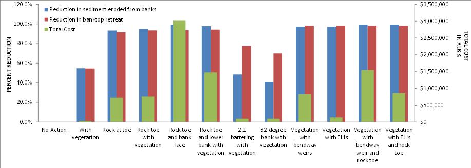
24 Burnett River, Queensland, AUS Objectives: January 2013 flood of record: RI at least 140 years 1. Protect local assets from bank erosion; 2. Determine costeffective treatments 3. Reduce fine loads to the Great Barrier Reef Bank erosion: 48 Mt over 3.8 years!!
25 Calibration: Once calibrated, 10-year simulations for no action and alternative strategies were conducted
26 Erosion under Alternative Treatments ELEVATION, in meters ELEVATION, in meters START PROFILE END NO ACTION END with vegetated bank END with rock toe END with rock toe and bank vegetation END rock toe and bank END rock toe and bank, and vegetation END vegetation and bendway weir END vegetation, bendway weir, rock toe and bank STATION, in meters No action END NO ACTION START 32 degree bank START 2:1 bank END 2:1 bank with vegetation END 32 degree bank with vegetation DISCHARGE, IN CUBICMETERS PER SECOND year flow series BMRG-02 Includes 2011 and 2013 floods STATION, in meters
27 Estimate Costs (similar relations for wood structures; heavy machinery; plantings, etc.) 14 VERTICAL HEIGHT OF ROCK, IN METERS Horizontal placement Vertical placement TONNES OF ROCK REQUIRED From D. Derrick, written comm., (2013) COST PER METER OF ROCK PLACEMENT* $$ = h r² = $$ = h r² = Bendway weirs Rock toe protection VERTICAL HEIGHT (h) OF ROCK, IN METERS Assuming $81.50/t (AUS)
28 Cost Effectiveness (to hold the line or not) Scenario Protection Cost effectiveness Unit Cost Unit Cost Total Cost Height Length By volume By retreat (m) (m) ($/m) ($/m 3 ) ($/m) ($) No Action - - $0 $0 $0 $0 With vegetation $ 66 $81 $1,230 $35,000 Rock at toe $ 1,360 $988 $15,200 $722,000 Rock toe with vegetation $ 1,430 $1,020 $15,600 $757,000 Rock toe and bank face $ 5,680 $3,890 $61,600 $3,012,000 Rock toe and lower bank with vegetation $ 2,790 $1,930 $30,200 $1,480,000 2:1 battering with vegetation $ 186 $259 $2,440 $98, degree bank with vegetation $ 186 $308 $2,710 $98,600 Vegetation with bendway weirs $ 1,560 $1,080 $2,700 $824,000 Vegetation with ELJs $ 260 $181 $30,300 $138,000 Vegetation with bendway weir and rock toe $ 2,920 $1,990 $30,300 $1,550,000 Vegetation with ELJs and rock toe $ 1,620 $1,110 $16,800 $860,000
29 Cost Effectiveness
30 Summary and Conclusions Gravity and the physics of erosion and sediment transport are a constant, allowing us to quantify force and resistance mechanisms. We can collect all of the data we need at a site/reach to quantify driving and resisting forces operating on the channel boundary Using principles of hydrology, hydraulics and geotechnics we can use our field data to inform numerical tools and models. Analyses and models can then be used to quantify performance and effectiveness of a range of alternative strategies By applying a cost basis to each strategy, we can provide a range of cost-effective options to be considered.
Erosion Rate is a Function of Erodibility and Excess Shear Stress = k ( o - c ) From Relation between Shear Stress and Erosion We Calculate c and
 From Relation between Shear Stress and Erosion We Calculate c and") Equilibrium, Shear Stress, Stream Power and Trends of Vertical Adjustment Andrew Simon USDA-ARS, Oxford, MS asimon@msa-oxford.ars.usda.gov Non-Cohesive versus Cohesive Materials Non-cohesive: sands and
Equilibrium, Shear Stress, Stream Power and Trends of Vertical Adjustment Andrew Simon USDA-ARS, Oxford, MS asimon@msa-oxford.ars.usda.gov Non-Cohesive versus Cohesive Materials Non-cohesive: sands and
Dr. Eddy Langendoen PUCP 2017
 Agricultural Research Service Channel Width Adjustment: Importance, Mechanics & Assessment Eddy J. Langendoen Research Hydraulic Engineer & Lead Scientist Watershed Physical Processes Research Unit US
Perspectives on river restoration science, geomorphic processes, and channel stability
 Perspectives on river restoration science, geomorphic processes, and channel stability Stream Restoration Forum: Science and Regulatory Connections Andrew C. Wilcox Department of Geosciences University
CONCEPTS Conservational Channel Evolution and Pollutant Transport System
 CONCEPTS Conservational Channel Evolution and Pollutant Transport System Eddy J. Langendoen Watershed Physical Processes Research Unit National Sedimentation Laboratory USDA Agricultural Research Service
Modelling riverbank retreat by combining reach-scale hydraulic models with bank-scale erosion and stability analyses
 River Flow 2010 - Dittrich, Koll, Aberle & Geisenhainer (eds) - 2010 Bundesanstalt für Wasserbau ISBN 978-3-939230-00-7 Modelling riverbank retreat by combining reach-scale hydraulic models with bank-scale
Sediment Sources, Baseline Sediment- Transport Rates and the Effectiveness of Restoration Measures for Reducing Loads to Receiving Waters
 Sediment Sources, Baseline Sediment- Transport Rates and the Effectiveness of Restoration Measures for Reducing Loads to Receiving Waters Andrew Simon Cardno, Oxford, MS, USA andrew.simon@cardno.com Not
Sensitivity Analysis of the Effective Parameters with Respect to Cantilever Type Failure in Composite Riverbanks
 Sensitivity Analysis of the Effective Parameters with Respect to Cantilever Type Failure in Composite Riverbanks A. Samadi 1, E. Amiri-Tokaldany 2, and M. H. Davoudi 3 1 Ph.D. Candidate, Department of
Probabilistic Evaluation of a Meandering Low-Flow Channel. February 24 th, UMSRS
 Probabilistic Evaluation of a Meandering Low-Flow Channel February 24 th, 2014 2014 UMSRS 1 2 acknowledgments Low- Flow Channel (LFC) overview Proposed Diversion Channel collects runoff from: The Rush
FE Fluids Review March 23, 2012 Steve Burian (Civil & Environmental Engineering)
") Topic: Fluid Properties 1. If 6 m 3 of oil weighs 47 kn, calculate its specific weight, density, and specific gravity. 2. 10.0 L of an incompressible liquid exert a force of 20 N at the earth s surface.
Topic: Fluid Properties 1. If 6 m 3 of oil weighs 47 kn, calculate its specific weight, density, and specific gravity. 2. 10.0 L of an incompressible liquid exert a force of 20 N at the earth s surface.
Technical Memorandum. To: From: Copies: Date: 10/19/2017. Subject: Project No.: Greg Laird, Courtney Moore. Kevin Pilgrim and Travis Stroth
 Technical Memorandum To: From: Greg Laird, Courtney Moore Kevin Pilgrim and Travis Stroth 5777 Central Avenue Suite 228 Boulder, CO 80301 www.otak.com Copies: [Electronic submittal] Date: 10/19/2017 Subject:
Sediment transport and river bed evolution
 1 Chapter 1 Sediment transport and river bed evolution 1.1 What is the sediment transport? What is the river bed evolution? System of the interaction between flow and river beds Rivers transport a variety
Spreadsheet Tools for Quantifying the Costs and Benefits of Two-Stage Channels
 Spreadsheet Tools for Quantifying the Costs and Benefits of Two-Stage Channels J. Witter, A. Ward, D. Mecklenburg, J. D Ambrosio, S. Roley, and J. Tank AWRA Agricultural Hydrology and Water Quality II
Carmel River Bank Stabilization at Rancho San Carlos Road Project Description and Work Plan March 2018
 Carmel River Bank Stabilization at Rancho San Carlos Road Project Description and Work Plan March 2018 EXISTING CONDITION The proposed Carmel River Bank Stabilization at Rancho San Carlos Road Project
Hydraulics of bendway weirs
 River Basin Management IV 389 Hydraulics of bendway weirs C. Thornton 1, S. Abt 1, D. Baird 2 & R. Padilla 3 1 Colorado State University, Fort Collins, CO, USA 2 U.S. Bureau of Reclamation, Denver, CO,
Slope Stability. loader
 Slope Stability Slope Stability loader Lower San Fernando Dam Failure, 1971 Outlines Introduction Definition of key terms Some types of slope failure Some causes of slope failure Shear Strength of Soils
Vegetation effects on river hydraulics. Johannes J. (Joe) DeVries David Ford Consulting Engineers, Inc. Sacramento, CA
 DeVries David Ford Consulting Engineers, Inc. Sacramento, CA") Vegetation effects on river hydraulics Johannes J. (Joe) DeVries David Ford Consulting Engineers, Inc. Sacramento, CA jjdevries@ford-consulting.com SAC05 D2P31 RM 99.0L VIEW UPSTREAM AT UPSTREAM END DWR
Vegetation effects on river hydraulics Johannes J. (Joe) DeVries David Ford Consulting Engineers, Inc. Sacramento, CA jjdevries@ford-consulting.com SAC05 D2P31 RM 99.0L VIEW UPSTREAM AT UPSTREAM END DWR
Limitation to qualitative stability indicators. the real world is a continuum, not a dichotomy ~ 100 % 30 % ~ 100 % ~ 40 %
 Stream Stability Assessment & BEHI Surveys Joe Rathbun MDEQ Water Resources Division rathbunj@michigan.gov 517--373 517 373--8868 Stability Stream can transport its water and sediment inputs without changing
The Importance of Riparian Vegetation in Channel Restoration: Moving Towards Quantification in Design
 The Importance of Riparian Vegetation in Channel Restoration: Moving Towards Quantification in Design Rob Millar Department of Civil Engineering The University of British Columbia "Nothing is as practical
Field Observations and One-Dimensional Flow Modeling of Summit Creek in Mack Park, Smithfield, Utah
 Intermountain Center for River Rehabilitation and Restoration, Utah State University 31 July 2018 Field Observations and One-Dimensional Flow Modeling of Summit Creek in Mack Park, Smithfield, Utah I.
Upper Truckee River Restoration Lake Tahoe, California Presented by Brendan Belby Sacramento, California
 Upper Truckee River Restoration Lake Tahoe, California Presented by Brendan Belby Sacramento, California Mike Rudd (Project Manager), Charley Miller & Chad Krofta Declines in Tahoe s Water Clarity The
Goundwater Seepage Mechanisms of Streambank Erosion and Failure
 Goundwater Seepage Mechanisms of Streambank Erosion and Failure Taber L. Midgley M.S. Student Garey A. Fox Associate Professor Abdulsahib Al-Madhhachi Ph.D. Student Rachel Carson M.S. Student Biosystems
MODELING OF LOCAL SCOUR AROUND AL-KUFA BRIDGE PIERS Saleh I. Khassaf, Saja Sadeq Shakir
 ISSN 2320-9100 11 International Journal of Advance Research, IJOAR.org Volume 1, Issue 8,August 2013, Online: ISSN 2320-9100 MODELING OF LOCAL SCOUR AROUND AL-KUFA BRIDGE PIERS Saleh I. Khassaf, Saja Sadeq
16 Rainfall on a Slope
 Rainfall on a Slope 16-1 16 Rainfall on a Slope 16.1 Problem Statement In this example, the stability of a generic slope is analyzed for two successive rainfall events of increasing intensity and decreasing
Erosion Surface Water. moving, transporting, and depositing sediment.
 + Erosion Surface Water moving, transporting, and depositing sediment. + Surface Water 2 Water from rainfall can hit Earth s surface and do a number of things: Slowly soak into the ground: Infiltration
A. V T = 1 B. Ms = 1 C. Vs = 1 D. Vv = 1
 Geology and Soil Mechanics 55401 /1A (2002-2003) Mark the best answer on the multiple choice answer sheet. 1. Soil mechanics is the application of hydraulics, geology and mechanics to problems relating
Geology and Soil Mechanics /1A ( ) Mark the best answer on the multiple choice answer sheet.
 Mark the best answer on the multiple choice answer sheet.") Geology and Soil Mechanics 55401 /1A (2003-2004) Mark the best answer on the multiple choice answer sheet. 1. Soil mechanics is the application of hydraulics, geology and mechanics to problems relating
Geology and Soil Mechanics 55401 /1A (2003-2004) Mark the best answer on the multiple choice answer sheet. 1. Soil mechanics is the application of hydraulics, geology and mechanics to problems relating
PENNSYLVANIA DEPARTMENT OF TRANSPORTATION ENGINEERING DISTRICT 3-0
 PENNSYLVANIA DEPARTMENT OF TRANSPORTATION ENGINEERING DISTRICT 3-0 LYCOMING COUNTY S.R.15, SECTION C41 FINAL HYDROLOGIC AND HYDRAULIC REPORT STEAM VALLEY RUN STREAM RELOCATION DATE: June, 2006 REVISED:
River Embankment Failure due to Overtopping - In Case of Non-cohesive Sediment -
 Nov 4, 2014 2014 International Workshop on Typhoon and Flood River Embankment Failure due to Overtopping - In Case of Non-cohesive Sediment - Prof. Hajime NAKAGAWA Prof. of Disaster Prevention Research
LAR BPWG. DWR Erosion Screening Process Application to LAR. May 17, water resource specialists
 LAR BPWG DWR Erosion Screening Process Application to LAR May 17, 2016 Presentation Outline Review of Erosion Screening Process Modifications for LAR Application ESP LAR Results Recommendations ESP Background
Modelling of flow and sediment transport in rivers and freshwater deltas Peggy Zinke
 1 Modelling of flow and sediment transport in rivers and freshwater deltas Peggy Zinke with contributions from Norwegian and international project partners 2 Outline 1. Introduction 2. Basic ideas of flow
Surface Processes Focus on Mass Wasting (Chapter 10)
") Surface Processes Focus on Mass Wasting (Chapter 10) 1. What is the distinction between weathering, mass wasting, and erosion? 2. What is the controlling force in mass wasting? What force provides resistance?
Surface Processes Focus on Mass Wasting (Chapter 10) 1. What is the distinction between weathering, mass wasting, and erosion? 2. What is the controlling force in mass wasting? What force provides resistance?
Development and testing of improved physically based streambank erosion and sediment routing routines in SWAT
 Development and testing of improved physically based streambank erosion and sediment routing routines in SWAT Balaji Narasimhan, P. M. Allen, Stephanie Capello, and Dave Coffman, J.G. Arnold, and R. Srinivasan
How to Design Bendway Weirs
 How to Design Bendway Weirs Project Background U.S. Bureau of Reclamation: Middle Rio Grande Channel Maintenance Program 29-Mile Study Reach: Cochiti Dam to Bernalillo Geomorphic Changes Due to Dam Construction
HAW CREEK, PIKE COUNTY, MISSOURI-TRIB TO SALT RIVER ERODING STREAM THREATHENING COUNTY ROAD #107, FOURTEEN FT TALL ERODING BANK WITHIN 4 FT OF THE
 HAW CREEK, PIKE COUNTY, MISSOURI-TRIB TO SALT RIVER ERODING STREAM THREATHENING COUNTY ROAD #107, FOURTEEN FT TALL ERODING BANK WITHIN 4 FT OF THE ROAD, PROJECT CONSTRUCTED IN 1 DAY, MARCH 10, 2009 BY
MATHEMATICAL MODELING OF FLUVIAL SEDIMENT DELIVERY, NEKA RIVER, IRAN. S.E. Kermani H. Golmaee M.Z. Ahmadi
 JOURNAL OF ENVIRONMENTAL HYDROLOGY The Electronic Journal of the International Association for Environmental Hydrology On the World Wide Web at http://www.hydroweb.com VOLUME 16 2008 MATHEMATICAL MODELING
Open Channel Flow Part 2. Ch 10 Young, notes, handouts
 Open Channel Flow Part 2 Ch 10 Young, notes, handouts Uniform Channel Flow Many situations have a good approximation d(v,y,q)/dx=0 Uniform flow Look at extended Bernoulli equation Friction slope exactly
MEANDER MIGRATION MODEL ASSESSMENT FOR THE JANUARY 2005 STORM, WHITMAN PROPERTY, SAN ANTONIO CREEK, VENTURA COUNTY, CALIFORNIA
 MEANDER MIGRATION MODEL ASSESSMENT FOR THE JANUARY 2005 STORM, WHITMAN PROPERTY, SAN ANTONIO CREEK, VENTURA COUNTY, CALIFORNIA Prepared by Eric Larsen, Ph.D. Mark Rains, Ph.D. October 2006 INTRODUCTION
Dam Removal Analysis Guidelines for Sediment
 A review of: Dam Removal Analysis Guidelines for Sediment Joe Rathbun (Retired) rathbunj@sbcglobal.net Some Potential Sediment Issues Reservoir restoration Downstream water quality Downstream deposition
Best Management Practices for Coldwater Fisheries Enhancement and Restoration
 Best Management Practices for Coldwater Fisheries Enhancement and Restoration MACC Annual Environmental Conference 2017 March 3, 2017 Tim Dexter, MassDOT Highway Division 1 Leading the Nation in Transportation
A STUDY OF LOCAL SCOUR AT BRIDGE PIERS OF EL-MINIA
 A STUDY OF LOCAL SCOUR AT BRIDGE PIERS OF EL-MINIA Dr. Gamal A. Sallam 1 and Dr. Medhat Aziz 2 ABSTRACT Bridges are critical structures that require a substantial investment to construct and serve an important
GEOSYNTHETICS ENGINEERING: IN THEORY AND PRACTICE
 GEOSYNTHETICS ENGINEERING: IN THEORY AND PRACTICE Prof. J. N. Mandal Department of civil engineering, IIT Bombay, Powai, Mumbai 400076, India. Tel.022-25767328 email: cejnm@civil.iitb.ac.in Module - 4
Rock Sizing for Small Dam Spillways
 Rock Sizing for Small Dam Spillways STORMWATER MANAGEMENT PRACTICES Photo 1 Rock-lined spillway on a construction site sediment basin Photo 2 Rock-lined spillway on a small farm dam 1. Introduction A chute
Ch 4a Stress, Strain and Shearing
 Ch. 4a - Stress, Strain, Shearing Page 1 Ch 4a Stress, Strain and Shearing Reading Assignment Ch. 4a Lecture Notes Sections 4.1-4.3 (Salgado) Other Materials Handout 4 Homework Assignment 3 Problems 4-13,
EXAMPLES (SEDIMENT TRANSPORT) AUTUMN 2018
 AUTUMN 2018") EXAMPLES (SEDIMENT TRANSPORT) AUTUMN 2018 Q1. Using Cheng s formula estimate the settling velocity of a sand particle of diameter 1 mm in: (a) air; (b) water. Q2. Find the critical Shields parameter diameter
EXAMPLES (SEDIMENT TRANSPORT) AUTUMN 2018 Q1. Using Cheng s formula estimate the settling velocity of a sand particle of diameter 1 mm in: (a) air; (b) water. Q2. Find the critical Shields parameter diameter
Prof. B V S Viswanadham, Department of Civil Engineering, IIT Bombay
 19 Module 5: Lecture -1 on Stability of Slopes Contents Stability analysis of a slope and finding critical slip surface; Sudden Draw down condition, effective stress and total stress analysis; Seismic
Countermeasure Calculations and Design
 Countermeasure Calculations and Design Summarized from Bridge Scour and Stream Instability Countermeasures, Experience, Selection, and Design Guidance, Second Edition, Publication No. FHWA NHI 01-003,
Essential Questions. What is erosion? What is mass wasting?
 Erosion Essential Questions What is erosion? What is mass wasting? What is Erosion? Erosion The transportation of sediment from one area to another Caused mainly by running water but also caused by glaciers,
Streams. Water. Hydrologic Cycle. Geol 104: Streams
 Streams Why study streams? Running water is the most important geologic agent in erosion, transportation and deposition of sediments. Water The unique physical and chemical properties of water make it
Closed duct flows are full of fluid, have no free surface within, and are driven by a pressure gradient along the duct axis.
 OPEN CHANNEL FLOW Open channel flow is a flow of liquid, basically water in a conduit with a free surface. The open channel flows are driven by gravity alone, and the pressure gradient at the atmospheric
Upper Mississippi River Basin Environmental Management Program Workshop
 Presentation to the Upper Mississippi River Basin Environmental Management Program Workshop by Michael Rodgers River Engineer US Army Corps of Engineers, St. Louis District August 17, 2007 Engineering
CASE STUDIES. Introduction
 Introduction The City of Winston-Salem faces the challenge of maintaining public infrastructure (e.g., water and sewer lines, storm drains, roads, culverts and bridges) while minimizing the potential impacts
Why Geomorphology for Fish Passage
 Channel Morphology - Stream Crossing Interactions An Overview Michael Love Michael Love & Associates mlove@h2odesigns.com (707) 476-8938 Why Geomorphology for Fish Passage 1. Understand the Scale of the
Combined Vertical And Lateral Channel Evolution Numerical Modeling
 City University of New York (CUNY) CUNY Academic Works International Conference on Hydroinformatics 8-1-2014 Combined Vertical And Lateral Channel Evolution Numerical Modeling Yong G. Lai Kuowei Wu Follow
Rapid Geomorphic Assessments: RGA s
 Establishing Current Reference Conditions Rates and concentrations of suspended-sediment transport vary over time and space due to factors such as precipitation characteristics and discharge, geology,
Uniform Channel Flow Basic Concepts. Definition of Uniform Flow
 Uniform Channel Flow Basic Concepts Hydromechanics VVR090 Uniform occurs when: Definition of Uniform Flow 1. The depth, flow area, and velocity at every cross section is constant 2. The energy grade line,
Lecture 10: River Channels
 GEOG415 Lecture 10: River Channels 10-1 Importance of channel characteristics Prediction of flow was the sole purpose of hydrology, and still is a very important aspect of hydrology. - Water balance gives
Degradation Concerns related to Bridge Structures in Alberta
 Degradation Concerns related to Bridge Structures in Alberta Introduction There has been recent discussion regarding the identification and assessment of stream degradation in terms of how it relates to
Instream Erosion Control General
 Instream Erosion Control General EROSION CONTROL TECHNIQUES Revegetation Temperate Climates Short-Term Non Vegetation Wet Tropics Long-Term Weed Control [1] Semi-Arid Zones Permanent [1] Weed control attributes
Rock Sizing for Waterway & Gully Chutes
 Rock Sizing for Waterway & Gully Chutes WATERWAY MANAGEMENT PRACTICES Photo 1 Rock-lined waterway chute Photo 2 Rock-lined gully chute 1. Introduction A waterway chute is a stabilised section of channel
Swift Creek Sediment Management Action Plan (SCSMAP)
") Swift Creek Sediment Management Action Plan (SCSMAP) PHASE 2 PROJECT PLAN PROPOSAL Whatcom County Public Works Department 322 N. Commercial Street, Suite 210 Bellingham, WA 98225 (360) 676-6692 June 2013
Swift Creek Sediment Management Action Plan (SCSMAP) PHASE 2 PROJECT PLAN PROPOSAL Whatcom County Public Works Department 322 N. Commercial Street, Suite 210 Bellingham, WA 98225 (360) 676-6692 June 2013
RAILWAYS AND FISH: HOW TO PROTECT AND ENHANCE FISH HABITAT VALUES AT STREAM CROSSINGS THROUGH PROJECT DESIGN AND CONSTRUCTION
 RAILWAYS AND FISH: HOW TO PROTECT AND ENHANCE FISH HABITAT VALUES AT STREAM CROSSINGS THROUGH PROJECT DESIGN AND CONSTRUCTION Rail Environment Conference November 2016 AGENDA Objective Background Benefits
ES 105 Surface Processes I. Hydrologic cycle A. Distribution % in oceans 2. >3% surface water a. +99% surface water in glaciers b.
 ES 105 Surface Processes I. Hydrologic cycle A. Distribution 1. +97% in oceans 2. >3% surface water a. +99% surface water in glaciers b. >1/3% liquid, fresh water in streams and lakes~1/10,000 of water
B-1. Attachment B-1. Evaluation of AdH Model Simplifications in Conowingo Reservoir Sediment Transport Modeling
 Attachment B-1 Evaluation of AdH Model Simplifications in Conowingo Reservoir Sediment Transport Modeling 1 October 2012 Lower Susquehanna River Watershed Assessment Evaluation of AdH Model Simplifications
Instructor : Dr. Jehad Hamad. Chapter (7)
") Instructor : Dr. Jehad Hamad Chapter (7) 2017-2016 Soil Properties Physical Properties Mechanical Properties Gradation and Structure Compressibility Soil-Water Relationships Shear Strength Bearing Capacity
Instructor : Dr. Jehad Hamad Chapter (7) 2017-2016 Soil Properties Physical Properties Mechanical Properties Gradation and Structure Compressibility Soil-Water Relationships Shear Strength Bearing Capacity
Erosion and Sediment Control Measures 2.7 Silt Fences
 Erosion and Sediment Control Measures Silt fences are designed to intercept sheet flow sediment laden stormwater run-off and filter out both the larger and smaller particles of sediment. Silt fences and
Nipigon River Landslide, Ontario, Canada
 Nipigon River Landslide, Ontario, Canada A. Abdelaziz, S. Besner, R. Boger, B. Fu, J. Deng, and A. Farina Presenter: Jian Deng, Ph.D, P.Eng Centre of Excellence for Sustainable Mining and Exploration,
Environmental Geology Chapter 9 Rivers and Flooding
 Environmental Geology Chapter 9 Rivers and Flooding Flooding in Pakistan 2010-1600 killed/20000 affected The hydrologic cycle is powered by the Sun The cycle includes evaporation, precipitation, infiltration,
Dan Miller + Kelly Burnett, Kelly Christiansen, Sharon Clarke, Lee Benda. GOAL Predict Channel Characteristics in Space and Time
 Broad-Scale Models Dan Miller + Kelly Burnett, Kelly Christiansen, Sharon Clarke, Lee Benda GOAL Predict Channel Characteristics in Space and Time Assess Potential for Fish Use and Productivity Assess
OBJECTIVES. Fluvial Geomorphology? STREAM CLASSIFICATION & RIVER ASSESSMENT
 STREAM CLASSIFICATION & RIVER ASSESSMENT Greg Babbit Graduate Research Assistant Dept. Forestry, Wildlife & Fisheries Seneca Creek, Monongahela National Forest, West Virginia OBJECTIVES Introduce basic
Quasi-three dimensional computations for flows and bed variations in curved channel with gently sloped outer bank
 River Sedimentation Wieprecht et al. (Eds) 2017 Taylor & Francis Group, London, ISBN 978-1-138-02945-3 Quasi-three dimensional computations for flows and bed variations in curved channel with gently sloped
Each basin is surrounded & defined by a drainage divide (high point from which water flows away) Channel initiation
 Channel initiation") DRAINAGE BASINS A drainage basin or watershed is defined from a downstream point, working upstream, to include all of the hillslope & channel areas which drain to that point Each basin is surrounded &
DRAINAGE BASINS A drainage basin or watershed is defined from a downstream point, working upstream, to include all of the hillslope & channel areas which drain to that point Each basin is surrounded &
HYDROLOGY AND HYDRAULICS MUSKEG RIVER BRIDGE
 PUBLIC WORKS CANADA HYDROLOGY AND HYDRAULICS MUSKEG RIVER BRIDGE KILOMETRE 207.9, LIARD HIGKWAY December 1978 I I f I I I I # Bolter Parish Trimble Ltd. ONLIULTINO Public Works, Canada, 9925-109 Street,
Landslides & Debris Flows
 T.#Perron# #12.001# #Landslides#&#Debris#Flows# 1# Landslides & Debris Flows Many geologic processes, including those shaping the land surface, are slowacting, involving feedbacks that operate over many
3/8/17. #20 - Landslides: Mitigation and Case Histories. Questions for Thought. Questions for Thought
 #20 - Landslides: Mitigation and Case Histories Web Exercise #3 (Volcanoes) Due Wednesday There is a 2-point penalty for every day the assignment is late. Exam 1 Scores Scores and exam key are posted Vaiont
2017 Soil Mechanics II and Exercises Final Exam. 2017/7/26 (Wed) 10:00-12:00 Kyotsu 4 Lecture room
 10:00-12:00 Kyotsu 4 Lecture room") 2017 Soil Mechanics II and Exercises Final Exam 2017/7/26 (Wed) 10:00-12:00 Kyotsu 4 Lecture room Attention: The exam consists of five questions for which you are provided with five answer sheets. Write
2017 Soil Mechanics II and Exercises Final Exam 2017/7/26 (Wed) 10:00-12:00 Kyotsu 4 Lecture room Attention: The exam consists of five questions for which you are provided with five answer sheets. Write
Project (Project No. US-CA-62-2) Maintenance Inspection and Reports (Subtask 14.1) Inspection Report No.2
 Maintenance Inspection and Reports (Subtask 14.1) Inspection Report No.2") MEMORANDUM TO: FROM: Jim Well, Ducks Unlimited Mike Harvey, PhD, PG SUBJECT: M&T/ Llano Seco Fish Screen Project (Project No. US-CA-62-2) Maintenance Inspection and Reports (Subtask 14.1) Inspection Report
MEMORANDUM TO: FROM: Jim Well, Ducks Unlimited Mike Harvey, PhD, PG SUBJECT: M&T/ Llano Seco Fish Screen Project (Project No. US-CA-62-2) Maintenance Inspection and Reports (Subtask 14.1) Inspection Report
Chris Lenhart, John Nieber, Ann Lewandowski, Jason Ulrich TOOLS AND STRATEGIES FOR REDUCING CHANNEL EROSION IN MINNESOTA
 Chris Lenhart, John Nieber, Ann Lewandowski, Jason Ulrich TOOLS AND STRATEGIES FOR REDUCING CHANNEL EROSION IN MINNESOTA Background and approach Channel loading major source of sediment in much of MN River
Application of the CONCEPTS Channel Evolution Model in Stream Restoration Strategies
 Application of the CONCEPTS Channel Evolution Model in Stream Restoration Strategies Eddy J. Langendoen National Sedimentation Laboratory, Agricultural Research Service, USDA, Oxford, Mississippi, USA
J. Paul Guyer, P.E., R.A.
 J. Paul Guyer, P.E., R.A. Paul Guyer is a registered mechanical engineer, civil engineer, fire protection engineer and architect with over 35 years experience in the design of buildings and related infrastructure.
Fluvial Processes in River Engineering
 Fluvial Processes in River Engineering Howard H. Chang San Diego State University... A WILEY-INTERSCIENCE PUBLTCATION John Wiley & Sons New York Chicbester Brisbane Toronto Singapore CONTENTS PARTI FLUVIAL
[1] Performance of the sediment trap depends on the type of outlet structure and the settling pond surface area.
![[1] Performance of the sediment trap depends on the type of outlet structure and the settling pond surface area.](/thumbs/76/74245181.jpg "[1] Performance of the sediment trap depends on the type of outlet structure and the settling pond surface area.") Sediment Trench SEDIMENT CONTROL TECHNIQUE Type 1 System Sheet Flow Sandy Soils Type 2 System [1] Concentrated Flow Clayey Soils Type 3 System [1] Supplementary Trap Dispersive Soils [1] Performance of
Sediment Trench SEDIMENT CONTROL TECHNIQUE Type 1 System Sheet Flow Sandy Soils Type 2 System [1] Concentrated Flow Clayey Soils Type 3 System [1] Supplementary Trap Dispersive Soils [1] Performance of
Mass Wasting. Requirements for Mass Wasting. Slope Stability. Geol 104: mass wasting
 Mass Wasting Movement of earth materials downslope, driven by Gravitational Forces. Landslides - general term for rock or soil movement. In U.S., on average, mass wasting causes 1 to 2 billion dollars
Seismic Analysis of Siri Dam Using Pseudo-Static Approach
 Seismic Analysis of Siri Dam Using Pseudo-Static Approach Shabbir Ahmed Osmani 1, Md. Jahir Bin Alam 2 1 Department of Civil Engineering, Leading University, Bangladesh 2 Department of Civil and Environmental
JOHN REDMOND RESERVOIR
 JOHN REDMOND RESERVOIR STREAMBANK STABILIZATION Hybrid Stream Solutions Leslie Ogar, Emelia Brooks, and Lizzie Hickman Prepared for the USACE Tulsa Office 5 December 2014 OUTLINE Introduction Technical
FUTURE MEANDER BEND MIGRATION AND FLOODPLAIN DEVELOPMENT PATTERNS NEAR RIVER MILES 200 TO 191 OF THE SACRAMENTO RIVER PHASE III REPORT
 FUTURE MEANDER BEND MIGRATION AND FLOODPLAIN DEVELOPMENT PATTERNS NEAR RIVER MILES 200 TO 191 OF THE SACRAMENTO RIVER PHASE III REPORT Eric W. Larsen REPORT FOR DUCKS UNLIMITED March 31, 2006-1 - Contents
Beaver Creek Corridor Design and Analysis. By: Alex Previte
 Beaver Creek Corridor Design and Analysis By: Alex Previte Overview Introduction Key concepts Model Development Design Accuracy Conclusion Refresh v = Beaver Creek Site = Wittenberg Introduction Low head
Closed duct flows are full of fluid, have no free surface within, and are driven by a pressure gradient along the duct axis.
 OPEN CHANNEL FLOW Open channel flow is a flow of liquid, basically water in a conduit with a free surface. The open channel flows are driven by gravity alone, and the pressure gradient at the atmospheric
Modeling Great Britain s Flood Defenses. Flood Defense in Great Britain. By Dr. Yizhong Qu
 Modeling Great Britain s Flood Defenses AIRCurrents Editor s note: AIR launched its Inland Flood Model for Great Britain in December 2008. The hazard module captures the physical processes of rainfall-runoff
Rock Sizing for Batter Chutes
 Rock Sizing for Batter Chutes STORMWATER MANAGEMENT PRACTICES Photo 1 Rock-lined batter chute Photo 2 Rock-lined batter chute 1. Introduction In the stormwater industry a chute is a steep drainage channel,
Improved physically based approaches for Channel Erosion Modeling in SWAT. Balaji Narasimhan, P. M. Allen, J. G. Arnold, and R.
 Improved physically based approaches for Channel Erosion Modeling in SWAT Balaji Narasimhan, P. M. Allen, J. G. Arnold, and R. Srinivasan Outline Channel Erosion Sediment Routing In SWAT2000 and SWAT2005
Aquifer an underground zone or layer of sand, gravel, or porous rock that is saturated with water.
 Aggradation raising of the streambed by deposition that occurs when the energy of the water flowing through a stream reach is insufficient to transport sediment conveyed from upstream. Alluvium a general
Avoiding Geohazards in the Mid-Atlantic Highlands by Using Natural Stream Principles
 Avoiding Geohazards in the Mid-Atlantic Highlands by Using Natural Stream Principles J. Steven Kite, WVU Neal Carte, WVDOT Will Harman, Michael Baker Corp. Donald D. Gray, WVU Photo: W. Gillespie North
Assessment. Assessment
 2001 SPRINGBROOK CREEK RESTORATION - THREE YEAR POST-CONSTRUCTION REVIEW - Presented by Bruce Henderson and Andy Harris 2005 River Restoration Northwest Symposium Skamania Lodge, Washington www.hendersonlandservices.com
STABILIZATION OF THE H&CT RAILWAY STONE DAM WALTER E. SKIPWITH, PE, JOYCE CRUM, AIA AND JOHN BAUMGARTNER, PE. Introduction.
 STABILIZATION OF THE H&CT RAILWAY STONE DAM WALTER E. SKIPWITH, PE, JOYCE CRUM, AIA AND JOHN BAUMGARTNER, PE I. A. Introduction General The Old Stone Dam is located in the upper reach of Cottonwood Creek
Modeling of long-term sedimentation in the Osijek port basin
 Water Management and Hydraulic Engineering 2015 Litera Brno, ISBN 978-80-214-5230-5, ISSN 2410-5910 Modeling of long-term sedimentation in the Osijek port basin G. Gilja, N. Kuspilić (Faculty of civil
Calculation of Stream Discharge Required to Move Bed Material
 Calculation of Stream Discharge Required to Move Bed Material Objective: Students will map two sections of a stream and calculate the depth, velocity, and discharge of flows required to move the stream
Pirai river (Bolivia)
") Pirai river (Bolivia) Confluent of the Amazon river which average discharge is only 6 m3/s, but with peak discharge over 5000 m3/s, a challenge for river basin management and for flood control HYDROEUROPE
Pirai river (Bolivia) Confluent of the Amazon river which average discharge is only 6 m3/s, but with peak discharge over 5000 m3/s, a challenge for river basin management and for flood control HYDROEUROPE
Important Copyright Information
 Important Copyright Information The following content is provided for educational purposes by the workshop presenter. This content may or may not have been peer reviewed. Information, opinions and recommendations
Do you think sediment transport is a concern?
 STREAM RESTORATION FRAMEWORK AND SEDIMENT TRANSPORT BASICS Pete Klingeman 1 What is Your Restoration Project Like? k? Do you think sediment transport is a concern? East Fork Lewis River, WA Tidal creek,
Can fluvial-hydraulic models accurately predict bed load transport in gravel bed streams?
 Can fluvial-hydraulic models accurately predict bed load transport in gravel bed streams? Scott B. Katz 1,2, Catalina Segura 1,2 1 Water Resources Graduate Program, 2 Department of Forest Engineering,