Albion Falls -Virtual Field Trip-
|
|
|
- Theresa Paul
- 5 years ago
- Views:
Transcription

1 Albion Falls -Virtual Field Trip- School of GEOGRAPHY & GEOLOGY Carolyn Eyles & Susan Vajoczki Prepared by Liz Kenny and Zachary Windus
2
.")
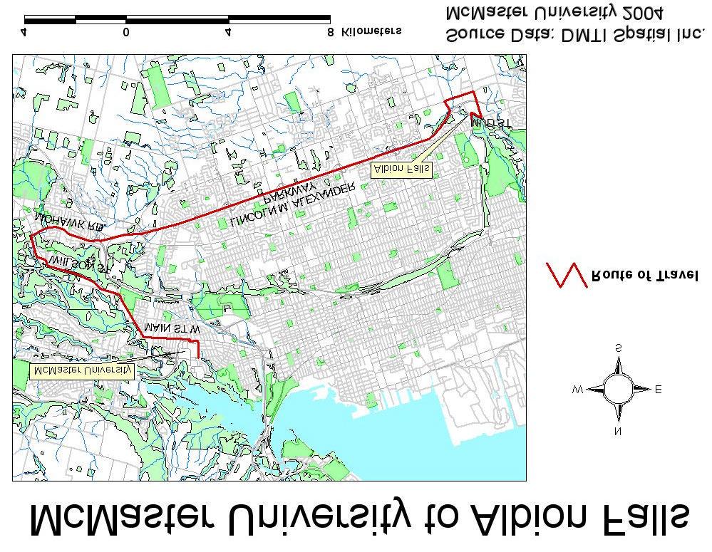
3 From McMaster University turn right onto Main Street West towards Ancaster. Follow Main Street West by turning left at the major intersection just past the Main West Mall (travelling straight will take you onto Osler Drive, Dundas). Main Street West becomes Wilson Street as you reach the bottom of the escarpment. Follow Wilson Street up the escarpment and turn left onto Rousseaux Street. This street becomes Mohawk Road and the Lincoln M. Alexander Parkway.

4 Exit the Lincoln M. Alexander Parkway at Dartnall Road. Turn left (east) at the lights onto Stone Church Road. Follow Stone Church Road to Pritchard Road and turn left. At Mud Street turn left and follow a sharp curve past the top of Albion Falls. Turn right into the parking area approximately 100m from the bridge. Additional parking can be found next to the Old Mill Pond across the street.

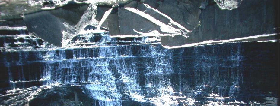
5 Albion Falls
 near the falls and the Grimsby Fm approximately 500m downstream from the falls.")
6 Features at this site Albion Falls Red Hill Creek cascades over the Niagara Escarpment. An excellent location for stratigraphic logging of the Thorold through t the Lockport Formations (Fm) near the falls and the Grimsby Fm approximately 500m downstream from the falls. Sedimentary structures (ripples, flute marks, cross-bedding, fossils) are observed near the falls. Soft sediment deformation features (flame structures, ball and pillow structures) are abundant within the Grimsby Fm downstream. During high water flow, the trail to the Grimsby Fm downstream may m not be accessible.


7 Memorial Albion Mills Milling stone dedicated in recognition of the area s early settlers. Located in the parking area North of the falls on Mud Street.


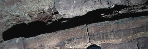
8 Albion Falls Flows over the dolostone of the Lockport Fm. Prominent ledge formed by the Irondequoit Fm.

9 Schematic Section of Albion Falls Highlighted formations are visible at this site.


10 Ancaster Member Lockport Fm Gasport Member Rochester Fm Backpack for scale


11 Irondequoit Formation Reynales Formation Thorold Formation Grimsby Formation


12 Lockport Formation Lockport Fm not well-exposed at this site due to vegetation cover.

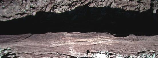
13 Rochester Formation Rochester shale beds are often poorly exposed m Irondequoit Formation Reynales Formation


.")
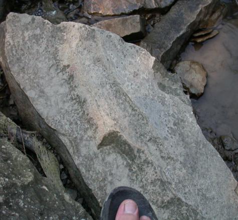
14 Irondequoit Formation Vug Massive to crudely bedded dolostone with vugs. Vugs large pore spaces caused by volume changes during diagenesis (the process by which limestone is changed to dolostone). Shell fragments within the Irondequoit Fm


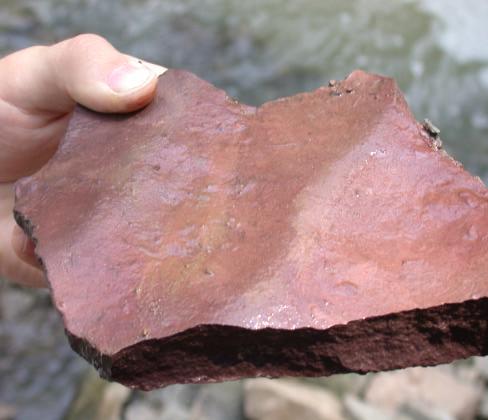
15 Reynales Formation Lockport Fm Irondequoit Fm Reynales Fm Thorold Fm Contact between Reynales and Thorold Fms. Exposures on the north bank, downstream of the falls.


")
16 Thorold Formation Interbedded sandstone and shale ripple structures (plan view) wave rippled sandstone


17 Thorold Formation Horizontally laminated sandstone interbedded with shale


18 Grimsby Formation Interbedded sandstone, siltstone, and shale Contact between the Thorold and Grimsby Formations Flute mark on base of sandstone bed

19 Grimsby Formation Wavy lamination and ripple cross lamination within Grimsby Fm.


20 Grimsby Formation Loading structures at the base of the sandstone bed within the Grimsby Fm. Sandstone pseudonodules within shale
21 Ripple Structures Ripples


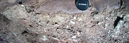
22 Other sights Natural and unnatural debris at Albion Falls.

23 The area directly below the falls is littered with debris which has broken and fallen from the escarpment.


24 For Further Information For further information on the features that can be seen downstream of Albion Falls, please see the Red Hill Valley Virtual Field Trip. View of the Red Hill Valley from Albion Falls

25 Acknowledgements: Maps Source Data: DMTI Spatial Inc. Photographs by Ben Cowie, Luisa DaSilva, Liz Kenny, and Zachary Windus Field assistance from Mark Francisco Based on an earlier slide field trip prepared by Alvin Chan and Sandra Rolph
Devil s Punchbowl -Virtual Field Trip-
 Devil s Punchbowl -Virtual Field Trip- School of GEOGRAPHY & GEOLOGY Carolyn Eyles & Susan Vajoczki Prepared by Zachary Windus and Liz Kenny From McMaster University take Main Street West towards Ancaster.
Sherman Falls -Virtual Field Trip-
 Sherman Falls -Virtual Field Trip- School of GEOGRAPHY & GEOLOGY Carolyn Eyles & Susan Vajoczki Prepared by Zachary Windus and Liz Kenny Directions: McMaster University to Sherman Falls From McMaster University
GEOLOGY. Subject : GEOLOGY (For under graduate student.) Paper No. : Paper 02 Introduction to Geology 02
 Paper No. : Paper 02 Introduction to Geology 02") GEOLOGY Subject : GEOLOGY (For under graduate student.) Paper No. : Paper 02 Introduction to Geology 02 Topic No. & Title : 56 Structure of Sedimentary Rocks Frequently Asked Questions FAQ s Que 01. What
GEOLOGY Subject : GEOLOGY (For under graduate student.) Paper No. : Paper 02 Introduction to Geology 02 Topic No. & Title : 56 Structure of Sedimentary Rocks Frequently Asked Questions FAQ s Que 01. What
sedimentary cover a) marine sediments b) continental sediments depth of crust: 5-10 km
 marine sediments b) continental sediments depth of crust: 5-10 km") Deformation and Brittle Fracture I. Primary Rock Structure A. Tectonic Control of Rock Structure 1. Lithospheric Plates a. plate = crust + upper mantle above asthenosphere (1) Layered Crust (a) oceanic
Deformation and Brittle Fracture I. Primary Rock Structure A. Tectonic Control of Rock Structure 1. Lithospheric Plates a. plate = crust + upper mantle above asthenosphere (1) Layered Crust (a) oceanic
Sedimentary Rocks. All sedimentary rocks begin to form when existing rocks are broken down into sediments Sediments are mainly weathered debris
 Rocks! Objectives Describe the major processes involved in the formation of sedimentary rock Distinguish between clastic sedimentary rocks and chemical sedimentary rocks Identify the features that are
American Institute of Professional Geologists South Dakota Section
 American Institute of Professional Geologists South Dakota Section 2015 Field Trip Guide Deadwood Formation in the Black Hills of South Dakota and Frac Sand Potential Saturday, September 12, 2015 1 Field
depression above scarp scarp
 1 LAB 1: FIELD TRIP TO McKINLEYVILLE AND MOUTH OF THE MAD RIVER OBJECTIVES: a. to look at geomorphic and geologic evidence for large scale thrust-faulting of young sediments in the Humboldt Bay region
Glaciers. 1. The photograph below shows the results of a landslide.
 Name: Date: 1. The photograph below shows the results of a landslide. This landslide is an example of A) wind abrasion B) glacial deposition C) wave action D) mass movement 2. Which agent of erosion is
Chapter 6 Sedimentary and Metamorphic Rock
 Chapter 6 Sedimentary and Metamorphic Rock Weathering and Erosion Wherever rock is exposed at Earth s surface, it is continuously being broken down by weathering a set of physical and chemical processes
Field trip guide to the Marin Headlands (Golden Gate National Recreation Area) and the Point Reyes National Seashore
 and the Point Reyes National Seashore") Name: Field trip guide to the Marin Headlands (Golden Gate National Recreation Area) and the Point Reyes National Seashore Geology of the National Parks San Francisco State University April 20, 2002 DRIVING
Name: Field trip guide to the Marin Headlands (Golden Gate National Recreation Area) and the Point Reyes National Seashore Geology of the National Parks San Francisco State University April 20, 2002 DRIVING
Geology Stratigraphic Correlations (Lab #4, Winter 2010)
") Name: Answers Reg. lab day: Tu W Th Geology 1023 Stratigraphic Correlations (Lab #4, Winter 2010) Introduction Stratigraphic correlation is the process of comparing rocks at one locality with related rocks
Name: Answers Reg. lab day: Tu W Th Geology 1023 Stratigraphic Correlations (Lab #4, Winter 2010) Introduction Stratigraphic correlation is the process of comparing rocks at one locality with related rocks
Field Trip 1 Tunnel Mill, Vernon, Indiana: Waldron Shale
 Geol G308 Paleontology and Geology of Indiana Name: Field Trip 1 Tunnel Mill, Vernon, Indiana: Waldron Shale On this trip we will visit Tunnel Mill, which is located just south of Vernon, Indiana in the
Data Repository item
 Data Repository (B25407): Localities and descriptions of measured sections of study areas Table 1. Localities of the measured sedimentary sections in the NW Sichuan Basin Section Number Stratigraphy Locality
Stratigraphy and structure of the Ganson Hill area: northern Taconic Allochthon
 University at Albany, State University of New York Scholars Archive Geology Theses and Dissertations Atmospheric and Environmental Sciences 1985 Stratigraphy and structure of the Ganson Hill area: northern
Field trip to Racine Reef Complex, Thornton Quarry, Illinois
 Field trip to Racine Reef Complex, Thornton Quarry, Illinois Primary objectives for this fieldtrip 1) Collect and identify the fossils of the Racine Reef Complex. 2) Discuss procedures for collecting fossil
NAME HOMEWORK ASSIGNMENT #3 MATERIAL COVERS CHAPTERS 8, 9, 10, 11
 NAME HOMEWORK ASSIGNMENT #3 MATERIAL OVERS HAPTERS 8, 9, 10, 11 Assignment is due the beginning of the class period on November 23, 2004. Answers for each chapter will be discussed in class, as Exam #3
 27 Figure 7 Poorly cleaved, massive, light-weathering Bomoseen graywacke outcrop located on Brandon Mountain Road. Figure 8 Photomicrograph of Bomoseen graywacke. Subangular, poorly sorted quartz grains
HW #2 Landscape Travel from A to B 12,
 HW #2 Landscape 2016 Section: Name: ate: 1. ase your answer(s) to the following question(s) on the map below, which represents two bridges that cross the Green River. Letters,, and represent locations
Geo 302D: Age of Dinosaurs. LAB 2: Sedimentary rocks and processes
 Geo 302D: Age of Dinosaurs LAB 2: Sedimentary rocks and processes Last week we covered the basic types of rocks and the rock cycle. This lab concentrates on sedimentary rocks. Sedimentary rocks have special
Sedimentary Rocks. Origin, Properties and Identification. Physical Geology GEOL 100. Ray Rector - Instructor
 Sedimentary Rocks Origin, Properties and Identification Physical Geology GEOL 100 Ray Rector - Instructor Sedimentary Rock Origin and Identification Lab Pre-Lab Internet Link Resources 1) http://www.rockhounds.com/rockshop/rockkey/index.html
UNIT 4 SEDIMENTARY ROCKS
 UNIT 4 SEDIMENTARY ROCKS WHAT ARE SEDIMENTS Sediments are loose Earth materials (unconsolidated materials) such as sand which are transported by the action of water, wind, glacial ice and gravity. These
=%REPORT RECONNAISSANCE OF CHISHOLM LAKE PROSPECT. October 25, 1977
 =%REPORT ON FIELD RECONNAISSANCE OF CHISHOLM LAKE PROSPECT October 25, 1977 Bruce D. Vincent Imperial Oil Limited, Minerals - Coal, CALGARY, ALBERTA CHISHOLM LAKE PROSPECT Introduction The Chisholm Lake
Sup. Mat. 1. Figure DR1. Map showing the distribution of the Vanrhynsdorp Group. 02
 GSA DATA REPOSITORY 2013142 Buatois, Almond and Germs Treptichnus pedum - List of supplementary materials: Sup. Mat. 1. Figure DR1. Map showing the distribution of the Vanrhynsdorp Group. 02 Sup. Mat.
Sedimentary Rocks. Origin, Properties and Identification. Geology Laboratory GEOL 101 Lab Ray Rector - Instructor
 Sedimentary Rocks Origin, Properties and Identification Geology Laboratory GEOL 101 Lab Ray Rector - Instructor Sedimentary Rock Origin and Identification Lab Pre-Lab Internet Link Resources 1) http://www.rockhounds.com/rockshop/rockkey/index.html
Appendix B.1 EMME Model Calibration Memo
 Appendix B.1 EMME Model Calibration Memo itrans 144 Front Street West, Suite 655 Toronto, ON M5J 2L7 Tel: (416) 847-0005 Fax: (905) 882-1557 www.hdrinc.com www.itransconsulting.com File: 2.0 Memorandum
Coso Red Hill and Coso Playa field trip, Prof. Alessandro Grippo, Ph.D.
 HISTORICAL GEOLOGY fall 2016 Professor: Dr. Alessandro Grippo, Ph.D. FIELD TRIP REPORT: Friday, October 21, 2016: Coso Red Hill & Playa, Coso Junction CA YOUR NAME part 1: COSO RED HILL (you can sample
Maine Geologic Facts and Localities October, Lobster Lake, Maine. Text by Robert G. Marvinney. Maine Geological Survey
 Maine Geologic Facts and Localities October, 1998 Lobster Lake, Maine 45 o 51 7.91 N, 69 o 30 53.88 W Text by Robert G. Marvinney, Department of Agriculture, Conservation & Forestry 1 Map by Introduction
Deltaic and Shallow Marine Lower Silurian Sediments of the Niagara Escarpment Between Hamilton, Ont. and Rochester, N.Y.
 Maritime Sediments, Vol. 10, No. 2, August, 1974 pp. 52-66 Reports 52 Deltaic and Shallow Marine Lower Silurian Sediments of the Niagara Escarpment Between Hamilton, Ont. and Rochester, N.Y. - A Field
Paleo Lab #4 - Sedimentary Environments
 Paleo Lab #4 - Sedimentary Environments page - 1. CHARACTERISTICS OF SEDIMENT Grain size and grain shape: The sizes and shapes of sedimentary particles (grains) are modified considerably during their transportation
1. The map below shows a meandering river. A A' is the location of a cross section. The arrows show the direction of the river flow.
 1. The map below shows a meandering river. A A' is the location of a cross section. The arrows show the direction of the river flow. Which cross section best represents the shape of the river bottom at
4/4. K What I know about Sedimentary Rocks. W What I want to find out about Sedimentary Rocks Sunday, April 7, 13
 Do Now (2 minutes) 4/4 K What I know about Sedimentary Rocks W What I want to find out about Sedimentary Rocks 1. 2. 3. 1. 2. 3. The Rock Cycle What is the rock cycle and how do rocks interrelate? Rock
GIFFORD PINCHOT STATE PARK DIABASE (MOLTEN LIQUID ROCK)
") PENNSYLVANIA TRAIL OF GEOLOGY PARK GUIDE 10 GIFFORD PINCHOT STATE PARK DIABASE (MOLTEN LIQUID ROCK) Gifford Pinchot State Park contains examples of the three major rock classes: igneous, metamorphic, and
PENNSYLVANIA TRAIL OF GEOLOGY PARK GUIDE 10 GIFFORD PINCHOT STATE PARK DIABASE (MOLTEN LIQUID ROCK) Gifford Pinchot State Park contains examples of the three major rock classes: igneous, metamorphic, and
Lecture Outline Wednesday - Friday February 14-16, 2018
 Lecture Outline Wednesday - Friday February 14-16, 2018 Quiz 2 scheduled for Friday Feb 23 (Interlude B, Chapters 6,7) Questions? Chapter 6 Pages of the Past: Sedimentary Rocks Key Points for today Be
Field Trip Workbook G200 Field Studies Sec 001 (Mt St. Helens north) Fall, 2018 Professor in charge: Alex Ruzicka TA : Secana Goudy
 Fall, 2018 Professor in charge: Alex Ruzicka TA : Secana Goudy") Field Trip Workbook NAME: G200 Field Studies Sec 001 (Mt St. Helens north) Fall, 2018 Professor in charge: Alex Ruzicka TA : Secana Goudy Use this workbook to answer the following questions about the geology
Field Trip Workbook NAME: G200 Field Studies Sec 001 (Mt St. Helens north) Fall, 2018 Professor in charge: Alex Ruzicka TA : Secana Goudy Use this workbook to answer the following questions about the geology
The Niagara Escarpment extends from western New York, through the GTA all the way up to Manitoulin Island and into Michigan and Wisconsin.
 is southern Ontario s most prominent topographic feature, extending more than 500 kilometres from western New York, through Niagara Falls and the western part of the Greater Toronto Area (GTA), and north
Sedimentary Structures in Metamorphic Rocks
 Maine Geologic Facts and Localities November, 2006 Primary Sedimentary Structures in Some Metamorphic Rocks Text by Thomas K. Weddle, Department of Agriculture, Conservation & Forestry 1 Photo by Thomas
Geology 12 FINAL EXAM PREP. Possible Written Response Exam Questions
 Geology 12 FINAL EXAM PREP Possible Written Response Exam Questions Use this study guide to prepare for the written response portion of the final exam. Name FINAL EXAM - POSSIBLE WRITTEN RESPONSE QUESTIONS
B) sorted and not layered D) unsorted and layered. 4. The photograph below shows farm buildings partially buried in silt.
 sorted and not layered D) unsorted and layered. 4. The photograph below shows farm buildings partially buried in silt.") Name 1. Base your answer to the following questio the-con our map below, which shows a hill formed by glacial deposition near Rochester, New York. Letters A through E are reference points. Elevations are
Name 1. Base your answer to the following questio the-con our map below, which shows a hill formed by glacial deposition near Rochester, New York. Letters A through E are reference points. Elevations are
Module 9 Sedimentary Rocks
 Module 9 Sedimentary Rocks SEDIMENTARY ROCKS Rocks formed from material derived from preexisting rocks by surfacial processes followed by diagenesis There are two main classes of sedimentary rocks Clastic
St. David's Buried Gorge
 1/7 cliffs Left: south Niagara of Whirlpool River just in autumn; north of the Bottom Whirlpool Right:inWhirlpool autumn; and Top up Right: the Niagara Gorge River in autumn Photo Gallery {igallery 0}
Sediments and Sedimentary Rocks
 Sediments and Sedimentary Rocks (Shaping Earth s Surface, Part 2) Science 330 Summer 2005 What is a sedimentary rock? Products of mechanical and chemical weathering Account for about 5 percent of Earth
Sedimentary Rocks. Origin, Properties and Identification. Physical Geology GEOL 101 Lab Ray Rector - Instructor
 Sedimentary Rocks Origin, Properties and Identification Physical Geology GEOL 101 Lab Ray Rector - Instructor Sedimentary Rock Origin and Identification Lab Pre-Lab Internet Link Resources 1) http://www.rockhounds.com/rockshop/rockkey/index.html
Name: NYS Geology and Landscapes and some River stuff
 Name: NYS Geology and Landscapes and some River stuff 1. Which types of surface bedrock are most likely found near Jamestown, New York? A) slate and marble B) quartzite and granite C) shale and sandstone
Sedimentary Rocks, our most Valuable Rocks. Or, what you will probably find when you are outdoors exploring.
 Sedimentary Rocks, our most Valuable Rocks Or, what you will probably find when you are outdoors exploring. Sedimentary rocks give us evidence to earth s earlier history. We look at processes happening
Pratice Surface Processes Test
 1. The cross section below shows the movement of wind-driven sand particles that strike a partly exposed basalt cobble located at the surface of a windy desert. Which cross section best represents the
Sediment and Sedimentary rock
 Sediment and Sedimentary rock Sediment: An accumulation of loose mineral grains, such as boulders, pebbles, sand, silt or mud, which are not cemented together. Mechanical and chemical weathering produces
GEOS 302 Lab 3: Sedimentary Structures (Reference Boggs, Chap.4)
") GEOS 302 Lab 3: Sedimentary Structures (Reference Boggs, Chap.4) Objectives: 1. Become familiar with the different sedimentary structures 2. Understand the origin of these different structures and be able
GEOS 302 Lab 3: Sedimentary Structures (Reference Boggs, Chap.4) Objectives: 1. Become familiar with the different sedimentary structures 2. Understand the origin of these different structures and be able
Structural Geology of the Mountains
 Structural Geology of the Mountains Clinton R. Tippett Shell Canada Limited, Calgary, Alberta clinton.tippett@shell.ca INTRODUCTION The Southern Rocky Mountains of Canada (Figure 1) are made up of several
Cape Breton Island Mineral Inventory Studies: A Sandstone Quarry Development Opportunity at Graham River (NTS 11F/14), Inverness County
, Inverness County") Report of Activities 2001 23 Cape Breton Island Mineral Inventory Studies: A Sandstone Quarry Development Opportunity at Graham River (NTS 11F/14), Inverness County G. J. DeMont and J. E. Hawken Compilation
Report of Activities 2001 23 Cape Breton Island Mineral Inventory Studies: A Sandstone Quarry Development Opportunity at Graham River (NTS 11F/14), Inverness County G. J. DeMont and J. E. Hawken Compilation
Chapter 6 Pages of Earth s Past: Sedimentary Rocks
 Chapter 6 Pages of Earth s Past: Sedimentary Rocks Introduction! Drilling into the bottom of the North Sea, we encounter: " Soft mud and loose sand, silt, pebbles, and shells. Then: " Similar materials
33. Eroding downstream left bank, new bridge, Attlebridge (TG ).
.") 33. Eroding downstream left bank, new bridge, Attlebridge (TG 12831675). 58 34. Eroding upstream right bank at Attlebridge Hall (TG 13871557), ford and cattle crossing. 35. Eroding upstream left bank at
33. Eroding downstream left bank, new bridge, Attlebridge (TG 12831675). 58 34. Eroding upstream right bank at Attlebridge Hall (TG 13871557), ford and cattle crossing. 35. Eroding upstream left bank at
Photo 119. Ripple marks in the Gordon Lake Formation. Highway 639 at the entrance to Laurentian Lodge.
 in particular of the Bruce Limestone by the Nipissing Diabase, has produced the rocks known as skarns (page 162). Regional metamorphism, particularly in the Massey - Whitefish Falls area, has produced
Lower Skinner Valley Fill Sandstones: Attractive Exploration Targets on the Northeast Oklahoma Platform*
 Lower Skinner Valley Fill Sandstones: Attractive Exploration Targets on the Northeast Oklahoma Platform* By Jim Puckette 1 Search and Discovery Article #10050 (2003) *Adapted from presentation to Tulsa
Structural Features and Fracture Orientation similarities between outcrops of the Ridgeley Sandstone
 The JUNIATA JOURNAL of GEOLOGY, 1, 1-8 (2014) Original article Structural Features and Fracture Orientation similarities between outcrops of the Ridgeley Sandstone Robert W. Baronner Two outcrops of the
Primary Structures in Sedimentary Rocks. Engr. Sultan A. Khoso
 Primary Structures in Sedimentary Rocks Engr. Sultan A. Khoso Sedimentary rocks Sedimentary rocks are those rocks which are formed by the weathered sediments of pre existing rocks (igneous or metamorphic
Geology 109L Lab 3: Modern Sedimentary Environments --Field Trip to Bodega Bay--
 Geology 109L Lab 3: Modern Sedimentary Environments --Field Trip to Bodega Bay-- Goal: The purpose of this lab is to recognize characteristics of modern sedimentary environments, which will aid you in
UPPER MANZANILLA FORMATION AT FISHING POND VILLAGE FIELDTRIP GUIDE
 UPPER MANZANILLA FORMATION AT FISHING POND VILLAGE FIELDTRIP GUIDE Saturday 10 th March 2012 Trip Leader: Georgia Huggins INTRODUCTION MANZANILLA Formation Author of name: WARING (G.A.) (1926.). The geology
A Geological Tour of Tumbledown Mountain, Maine
 Maine Geologic Facts and Localities April, 1998 A Geological Tour of Tumbledown Mountain, Maine 44 45 3.21 N, 70 32 50.24 W Text by Robert G. Marvinney, Department of Agriculture, Conservation & Forestry
Unit 3 Review - Surface Processes
 Unit 3 Review - Surface Processes 1. Why is the surface of Mercury covered with meteor impact craters, while Earth s surface has relatively few craters? A) Mercury is larger than Earth, so it gets hit
Nathan D. Webb and James L. Best
 Nathan D. Webb and James L. Best Background Pennsylvanian oil production Stratigraphy & geologic setting Study area Methods Using geophysical logs & core Results Comparing three channel deposits Implications
Reservoir Characteristics of the Birdbear Formation in West- Central Saskatchewan
 Reservoir Characteristics of the Birdbear Formation in West- Central Saskatchewan Chao Yang Petroleum Geology Branch Exploration and Geological Services Division Saskatchewan Ministry of Energy and Resources
Shale Gas Opportunities in Southern Ontario an Update
 Shale Gas Opportunities in Southern Ontario an Update Terry Carter, Ministry of Natural Resources, London, ON Lee Fortner, Ministry of Natural Resources, London, ON Catherine Béland-Otis, Ontario Geological
Wonder as you Wander up the Carding Mill Valley
 Wonder as you Wander up the Carding Mill Valley Spot clues to the 600 million year old history of the Long Mynd. Consider how the Earth has evolved since the rock you are walking over first formed. Welcome
Geology of the Golden Gate National Recreation Area in the Marin Headlands, and Ring Mountain, Tiburon
 Geology of the Golden Gate National Recreation Area in the Marin Headlands, and Ring Mountain, Tiburon May 9, 2006 Field trip guide compiled by Mary Leech Name: Submit this guide with the Subduction lab
Journal of Sedimentary Environments Published by Universidade do Estado do Rio de Janeiro SM2: doi: /jse SUPPLEMENTARY MATERIAL
 Appendix 2 Citation: Bergamaschi, S., Duarte, A.C.F., Serrano, J.S., Figueiredo, A.M.B., Vasconcelos, L.C., Oliveira, R.M.A.G., Ade, M.V.B., Pinheiro, A.E.P.P., Martins, M.V.A., 2016. Regional outcrops
Rock Star 101. Introduction to Rocks.
 Rock Star 101 Introduction to Rocks www.mineralsed.ca Lesson 1: Rocks are made of minerals. Element, Mineral, Rock, Outcrop Lesson 2: Rock formation is cyclic. Lesson 3: Igneous rocks crystallize from
GEOL 104 Dinosaurs: A Natural History Geology Assignment. DUE: Mon. Sept. 19
 GEOL 104 Dinosaurs: A Natural History Geology Assignment DUE: Mon. Sept. 19 Part I: Environments of Deposition Geologists can use various clues in sedimentary rocks to interpret their environment of deposition:
Site 4.7. Thornhill Drumlin Jane K. Hart
 Site 4.7. Thornhill Drumlin Jane K. Hart Introduction The drumlins in the West of Ireland represent some of the best exposured features in the whole of Britain and Ireland, and have been studied by numerous
Sedimentary Rocks - are one of the three main rock types
 Today s Objective: What Makes Sedimentary Rocks Special? Sedimentary Rocks - are one of the three main rock types A sedimentary rock can form one of three ways: 1. by the deposition of the weathered remains
Sedimentary and Stratigraphic Analysis of the Viking Sand in the Edgerton/Wainwright Area, Central Alberta* By Russell Walz 1
 Sedimentary and Stratigraphic Analysis of the Viking Sand in the Edgerton/Wainwright Area, Central Alberta* By Russell Walz 1 Search and Discovery Article #50030 (2006) Posted June 25, 2006 *Extended abstract
GPEX Mineral Property Portfolio. Coquihalla Gold Belt. ~ Ladner Suite ~
 GPEX Mineral Property Portfolio Coquihalla Gold Belt ~ Ladner Suite ~ GPEX s Ladner Suite consists of four properties, the Silver Salem, the Emancipation East, the Ladner Junction and West Hozameen claims.
Geological History of the Grand Canyon
 Geological History of the Grand Canyon For a copy of this assignment, print a copy of this web page. The Project Your job is to write a short paper that describes the geological history of the Grand Canyon
Concretions are accumulation of one or more minerals within the body of a sedimentary rock, or within
 Tibooburra concretions Page 1 Concretions are accumulation of one or more minerals within the body of a sedimentary rock, or within cracks and cavities in a rock. They form when minerals such as quartz,
Subsurface Geology and Resource Exploration
 LAB 11. Subsurface Geology and Resource Exploration Locating earth resources such as aluminum, copper, gold and gemstones has been an important job for geologists for a long time. This lab deals with the
LINGUAU DEPOSITION IN THE WOODBINE SANDS ALONG COPPERAS BRANCH, DENTON COUNTY. TEXAS: A STUDY IN MARINE SEDIMENTATION
 LINGUAU DEPOSITION IN THE WOODBINE SANDS ALONG COPPERAS BRANCH, DENTON COUNTY. TEXAS: A STUDY IN MARINE SEDIMENTATION Ellis W. Shuler and Olin M. Millican The lack of outcrops in three dimensions often
Sedimentary rocks. Mechanical Weathering. Weathering. Chemical weathering. Rates of weathering. Fossil Fuel Resources. Two kinds of weathering
 Sedimentary rocks Fossil Fuel Resources Exam next Tuesday February 14 Bring Scantron and Review Questions About 75% of all rock outcrops on the continents Important to reconstruct much of Earth's history
Sedimentary Environments Chapter 8
 Sedimentary Environments Chapter 8 Does not contain complete lecture notes. To be used to help organize lecture notes and home/test studies. What is a sedimentary rock? Sedimentary rocks are products of
Characteristic of the deep-water channels in the Lower Miocene Pulau Balang Formation in Samarinda
 Characteristic of the deep-water channels in the Lower Miocene Pulau Balang Formation in Samarinda Abdurrokhim*, Djadjang J Setiadi, Faisal Helmi, Adi Hardiyono, and Yoga A Sendjaja Faculty of Geology,
GSA Data Repository Item
 GSA Data Repository Item 2011097 Verdel, C., Wernicke, B. P. and Bowring, S. A., The Shuram and subsequent Ediacaran carbon isotope excursions from southwest Laurentia: Geological Society of America Bulletin
GEOLOGICAL AGE OF ROCKS. Absolute geological age
 GEOLOGICAL AGE OF ROCKS Absolute geological age The pioneer of nuclear physics discovered at the turn of centuries that atoms of certain elements, the radioactive ones, spontaneously disintegrate to form
Cattaraugus Creek: A Story of Flowing Water and the Geology of the Channel It Flows Through Presentation to West Valley Citizen Task Force 4/27/16
 Cattaraugus Creek: A Story of Flowing Water and the Geology of the Channel It Flows Through Presentation to West Valley Citizen Task Force 4/27/16 Raymond C. Vaughan, Ph.D. What happens if you drop a
Holocene Meander Incision Imposed Across a Buried Valley Wall
 Holocene Meander Incision Imposed Across a Buried Valley Wall Michael P. Wilson Geosciences Department SUNY College at Fredonia Fredonia, NY 14063 (716/673-3843) and William T. Boria Division of Environmental
Name: Which rock layers appear to be most resistant to weathering? A) A, C, and E B) B and D
 A, C, and E B) B and D") Name: 1) The formation of soil is primarily the result of A) stream deposition and runoff B) precipitation and wind erosion C) stream erosion and mass movement D) weathering and biological activity 2)
Name: 1) The formation of soil is primarily the result of A) stream deposition and runoff B) precipitation and wind erosion C) stream erosion and mass movement D) weathering and biological activity 2)
Mud Sand Gravel. Clastic Textures
 Sed Rocks Self-Instruction Lab Name Geology 100 Harbor Section Please see the questions online before you begin. Sedimentary rocks are usually identified in the field by their stratification or layering,
A Sedimentary Rock is..
 Sedimentary Rocks A Sedimentary Rock is.. rock formed from the lithification or crystallization of: 1. Minerals in solution 2. Organic remains 3. Materials produced by living things (biochemical) 4. Clastic
Clastic Textures. I. What is the sorting of sample numbers 60, 61, and 62? Answers on last page.
 Sed Rock s Sel f-instruction N ame Geology 100 Harbor Secti on Sedimentary rocks are usually identified in the field by their stratification or layering, which originates by the successive deposition of
NC Earth Science Essential Standards
 NC Earth Science Essential Standards EEn. 2.1 Explain how processes and forces affect the Lithosphere. EEn. 2.1.1 Explain how the rock cycle, plate tectonics, volcanoes, and earthquakes impact the Lithosphere.
What is a sedimentary rock?
 Sedimentary Rocks What is a sedimentary rock? Sedimentary rocks are products of mechanical and chemical weathering They account for only 5% of the top 10 miles of the outer crust, yet most of the earth
Cretaceous, Dakota Formation, Terra Cotta Member South Side of I-70, Salina County, Kansas
 Cretaceous, Dakota Formation, Terra Cotta Member South Side of I-70, Salina County, Kansas Written By: Steven D.J. Baumann G-102010-1A Outcrop looking southeast Photo taken by: Steven Baumann on 10-20-2010
GEL 109 Midterm W05, Page points total (1 point per minute is a good pace, but it is good to have time to recheck your answers!
 GEL 109 Midterm W05, Page 1 50 points total (1 point per minute is a good pace, but it is good to have time to recheck your answers!) 1. Are the following flow types typically laminar or turbulent and
Understanding Earth Fifth Edition
 Understanding Earth Fifth Edition Grotzinger Jordan Press Siever Chapter 5: SEDIMENTATION: Rocks Formed by Surface Processes Lecturer: H Mohammadzadeh Assistant professors, Department of Geology, FUM Copyright
A Sedimentary Rock is..
 Sedimentary Rocks A Sedimentary Rock is.. rock formed from the lithification or crystallization of: 1. Minerals in solution 2. Organic remains 3. Materials produced by living things (biochemical) 4. Clastic
Geology of the Hawaiian Islands
 Geology of the Hawaiian Islands Class 12 19 February 2004 A B C D F 97 94 92 91 88 87 86 85 85 84 82 77 73 73 mean 66 64 60 69 60 57 51 29 Exam Scores Mean = 71 Median = 82/77 Any Questions? Sedimentary
Earth Materials Unit: Sedimen ntary Rocks and Processes Maybe One Day Text: Chapters Five and Six Lab: Laboratorry Six Name
 Earth Materi ials Unit: Sedimentary Rocks and Proces sses Maybe One Day Text: Chapters Fivee and Six Lab: Laboratory Six Name Page 1 Sedimentary Rocks and Processes Purpose: To classify sedimentary rocks
Sedimentary Rocks Reading with Questions (Pg. 3-6) Scheme for Sedimentary Rock Identification Video (Mr. White s website) Questions (Pg.
 Scheme for Sedimentary Rock Identification Video (Mr. White s website) Questions (Pg.") Do At Least 2 Must Do All NAME: Kick Off Activity Comparing Sedimentary and Igneous Rocks (Pg. 2) The Foundation Sedimentary Rocks Reading with Questions (Pg. 3-6) Scheme for Sedimentary Rock Identification
Do At Least 2 Must Do All NAME: Kick Off Activity Comparing Sedimentary and Igneous Rocks (Pg. 2) The Foundation Sedimentary Rocks Reading with Questions (Pg. 3-6) Scheme for Sedimentary Rock Identification
Guided Notes Rocks & Minerals
 Guided Notes Rocks & Minerals is Mineral 1.What is a Mineral Tests 2.Mineral Properties Cycle 3.Rock Rocks 4.Igneous Rocks 5.Sedimentary Rocks 6. Metamorphic Rocks Reference Tables K. Coder 2015 12. What
Sediments and. Sedimentary Rocks
 Sediments and Sedimentary Rocks Bottom Line Sedimentary rocks form from particles accumulated in sedimentary layers Sedimentary layers can be formed by clastic or detrital particles (e.g., sand grains,
Field Meeting Report: Coniston, led by Derek Leviston 18 th May 1986
 ISSN 1750-855X (Print) ISSN 1750-8568 (Online) Field Meeting Report: Coniston, led by Derek Leviston 18 th May 1986 Les Dolamore 1 DOLAMORE, L. (1987). Field Meeting Report: Carrock Fell, led by Derek
Answers: Internal Processes and Structures (Isostasy)
") Answers: Internal Processes and Structures (Isostasy) 1. Analyse the adjustment of the crust to changes in loads associated with volcanism, mountain building, erosion, and glaciation by using the concept
Answers: Internal Processes and Structures (Isostasy) 1. Analyse the adjustment of the crust to changes in loads associated with volcanism, mountain building, erosion, and glaciation by using the concept
N. J. Macala. C ONTENT S. LIST OF PLATES.
 REPORT ON WATER SUikLY AT MANBULLOO STATION, NORTHERN TERRITORY. by N. J. Macala. Records 1957/62. C ONTENT S. Page. Introduction. 1. General Geology, 1. Hydrology. 1. New Bore Sites Selected. 2. Reference.