Sherman Falls -Virtual Field Trip-
|
|
|
- Ashlyn McDowell
- 5 years ago
- Views:
Transcription

1 Sherman Falls -Virtual Field Trip- School of GEOGRAPHY & GEOLOGY Carolyn Eyles & Susan Vajoczki Prepared by Zachary Windus and Liz Kenny
.")
. At the stop sign, turn right onto Old Dundas Road.")
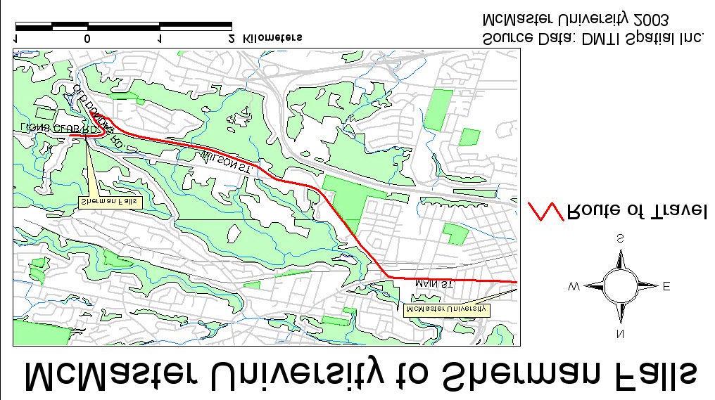
2 Directions: McMaster University to Sherman Falls From McMaster University turn right onto Main Street West towards s Ancaster. Follow Main Street West by turning left at the major intersection n just past the Main West Mall (travelling straight will take you onto Osler Drive, Dundas). Main Street West becomes Wilson Street as you reach the bottom of the escarpment. Follow Wilson Street up the south mountain access. Turn T right at Montgomery Street (very short street not labeled on map). At the stop sign, turn right onto Old Dundas Road. Follow Old Dundas Road down the escarpment and go straight at the stop sign that leads to Lions Club Road. Park on the shoulder. There is a wider space further down the road where a school bus can turn around. The falls are located on the left hand side and are approximately 250 m from the road. The trails (marked with a Bruce Trail Marker) lead from the road (at the bridge) along either side of the Ancaster Creek to the walking bridge and the falls.
3

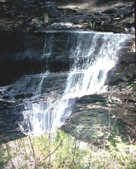
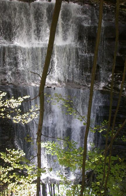
4 Sherman Falls

5 Schematic Section of Sherman Falls Highlighted formations are visible at this site.

6 Stratigraphy Exposed at Sherman Falls Lockport Formation Rochester Formation Irondequoit Formation Reynales Formation Thorold Formation
 Rochester Fm")
7 Upper Stratigraphy Lockport Fm (Ancaster Member) Lockport Fm (Gasport Member) Rochester Fm Irondequoit Fm


8 Lockport Formation The Lockport Formation forms the upper part of the gorge at this site.

9 Rochester Formation All around the gorge, the Rochester Shale has been undercut by erosion, leaving a noticeable contact between this formation and the overlying Lockport dolostone. This undercutting results in the collapse of the overlying material and gives the escarpment its steep face.


10 Irondequoit Formation This massive unit of dolostone can be seen around the gorge. At this location, however, it is slightly more fractured and jointed than at other outcrops along the escarpment. At the waterfall, the Irondequoit Fm forms the prominent ledge upon which the person is standing.


11 Reynales Formation Interbedded dolostones and shales of the Reynales Formation are not well exposed at this site, as they are largely covered by talus.


12 Thorold Formation Interbedded sandstone and shale of the Thorold Fm are well exposed at the waterfall, but are buried by talus around the rest of the gorge.

13 The Waterfall Exposure Rochester Formation Irondequoit Formation Reynales Formation Thorold Formation The Irondequoit Formation at this site forms the main bench in the middle of the waterfall, with the units above it having been eroded back. Due to the steepness of the valley walls and the extent of talus coverage, most of the geological units in the gorge are difficult to see. However, immediately adjacent to the falls, the units are easily visible and identifiable.

14 Broken debris of various sizes litters the bottom of the waterfall; here, a large piece of the Irondequoit dolostone sits where it has fallen, as the velocity and amount of flow of the stream are insufficient to move such a large piece of rock.

15 Ancaster Creek Unlike many other streams, the Ancaster Creek flows naturally through the gorge, unimpeded by any anthropogenic modifications such as weirs, gabions, or artificial channels.

16 While the stream is fairly shallow at most points, there are certain areas where it can become quite deep without warning.

17 The gorge at Sherman Falls is heavily vegetated and covered by a fairly thick canopy of trees. The Gorge
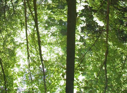

18 Vegetation at Sherman Falls

19 Narrow, steep-walled gorge close to Sherman Falls.

20 Talus slopes covering most of the lower formations. Irondequoit Fm Talus

21 Other features of the gorge include J-shaped trees which grow on the sides of the valley and indicate active slope creep.

22 The valley floor is littered with plant and rockfall debris, making hiking difficult in some areas.

23 Looking towards the bridge and the falls.


24 Field Work Due to its accessibility and the presence of many geological and geomorphological features, Sherman Falls is a site that used extensively for field work.

25 Acknowledgements: Map Source Data: DMTI Spatial Inc. Photographs by Ben Cowie, Luisa DaSilva, Liz Kenny, and Zachary Windus Downstream of the falls, Ancaster Creek meanders through the gorge.
Devil s Punchbowl -Virtual Field Trip-
 Devil s Punchbowl -Virtual Field Trip- School of GEOGRAPHY & GEOLOGY Carolyn Eyles & Susan Vajoczki Prepared by Zachary Windus and Liz Kenny From McMaster University take Main Street West towards Ancaster.
Albion Falls -Virtual Field Trip-
 Albion Falls -Virtual Field Trip- School of GEOGRAPHY & GEOLOGY Carolyn Eyles & Susan Vajoczki Prepared by Liz Kenny and Zachary Windus From McMaster University turn right onto Main Street West towards
Field Trip Workbook G200 Field Studies Sec 001 (Mt St. Helens north) Fall, 2018 Professor in charge: Alex Ruzicka TA : Secana Goudy
 Fall, 2018 Professor in charge: Alex Ruzicka TA : Secana Goudy") Field Trip Workbook NAME: G200 Field Studies Sec 001 (Mt St. Helens north) Fall, 2018 Professor in charge: Alex Ruzicka TA : Secana Goudy Use this workbook to answer the following questions about the geology
Field Trip Workbook NAME: G200 Field Studies Sec 001 (Mt St. Helens north) Fall, 2018 Professor in charge: Alex Ruzicka TA : Secana Goudy Use this workbook to answer the following questions about the geology
US82 ROCKFALL MITIGATION PROJECT May, BY Mohammed Ghweir Engineering Geologist Geotechnical Design Section New Mexico DOT
 US82 ROCKFALL MITIGATION PROJECT May, 2009 BY Mohammed Ghweir Engineering Geologist Geotechnical Design Section New Mexico DOT SACRAMENTO MTS Rock Fall Signs Back Ground US82 Connects the Town of Alamogordo,
HW #2 Landscape Travel from A to B 12,
 HW #2 Landscape 2016 Section: Name: ate: 1. ase your answer(s) to the following question(s) on the map below, which represents two bridges that cross the Green River. Letters,, and represent locations
ENGINEERING EVALUATION OF THE STANLEY MINE ADVENTURE PARK AREA CLEAR CREEK COUNTY, COLORADO. Prepared for:
 braun Braun Consulting Engineers ENGINEERING EVALUATION OF THE STANLEY MINE ADVENTURE PARK AREA CLEAR CREEK COUNTY, COLORADO Prepared for: STANLEY MINES ADENTURE PARK 3375 W. POWERS CIRCLE LITTLETON, COLORADO
The Niagara Escarpment extends from western New York, through the GTA all the way up to Manitoulin Island and into Michigan and Wisconsin.
 is southern Ontario s most prominent topographic feature, extending more than 500 kilometres from western New York, through Niagara Falls and the western part of the Greater Toronto Area (GTA), and north
Questions for the Edwards formation
 Name: Professor name: Class Time: The Virtual Field trip is to be completed by your self. You should not work with a partner. This is not group work. Nor should you search for answers on the internet.
Field Trip Number One. By: Pat Dryer. Geography 360
 Field Trip Number One By: Pat Dryer Geography 360 Table of Contents Introduction. Page 1 Stop One... Page 2 Stop Two... Page 4 Stop Three... Page 5 Stop Four... Page 7 Bibliography Page 8 Campus Map Source:
Flood and Stream Restoration
 2 3 4 Pedestrian bridge under construction 3 CSPs perched on DS side Large area of sand deposition Bottom layer of gabions has been scoured out large bar of gabion stone Gabions slumping bank slope failure
unit 6 Review sheet 4. The photograph below shows a sandstone butte in an arid region. A. U-shaped valley B. V-shaped valley C. cliff D.
 Name: ate: 1. The large waterfall at Niagara Falls, New York, was originally located at the Niagara Escarpment. Which term best describes an escarpment? 4. The photograph below shows a sandstone butte
mountain rivers fixed channel boundaries (bedrock banks and bed) high transport capacity low storage input output
 high transport capacity low storage input output") mountain rivers fixed channel boundaries (bedrock banks and bed) high transport capacity low storage input output strong interaction between streams & hillslopes Sediment Budgets for Mountain Rivers Little
mountain rivers fixed channel boundaries (bedrock banks and bed) high transport capacity low storage input output strong interaction between streams & hillslopes Sediment Budgets for Mountain Rivers Little
Name: NYS Geology and Landscapes and some River stuff
 Name: NYS Geology and Landscapes and some River stuff 1. Which types of surface bedrock are most likely found near Jamestown, New York? A) slate and marble B) quartzite and granite C) shale and sandstone
3.12 Geology and Topography Affected Environment
 3 Affected Environment and Environmental Consequences 3.12 Geology and Topography 3.12.1 Affected Environment 3.12.1.1 Earthquakes Sterling Highway MP 45 60 Project Draft SEIS The Kenai Peninsula is predisposed
American Institute of Professional Geologists South Dakota Section
 American Institute of Professional Geologists South Dakota Section 2015 Field Trip Guide Deadwood Formation in the Black Hills of South Dakota and Frac Sand Potential Saturday, September 12, 2015 1 Field
Glaciers. 1. The photograph below shows the results of a landslide.
 Name: Date: 1. The photograph below shows the results of a landslide. This landslide is an example of A) wind abrasion B) glacial deposition C) wave action D) mass movement 2. Which agent of erosion is
The Effects of Hydraulic Structures on Streams Prone to Bank Erosion in an Intense Flood Event: A Case Study from Eastern Hokkaido
 Symposium Proceedings of the INTERPRAENENT 2018 in the Pacific Rim The Effects of Hydraulic Structures on Streams Prone to Bank Erosion in an Intense Flood Event: A Case Study from Eastern Hokkaido Daisuke
GIFFORD PINCHOT STATE PARK DIABASE (MOLTEN LIQUID ROCK)
") PENNSYLVANIA TRAIL OF GEOLOGY PARK GUIDE 10 GIFFORD PINCHOT STATE PARK DIABASE (MOLTEN LIQUID ROCK) Gifford Pinchot State Park contains examples of the three major rock classes: igneous, metamorphic, and
PENNSYLVANIA TRAIL OF GEOLOGY PARK GUIDE 10 GIFFORD PINCHOT STATE PARK DIABASE (MOLTEN LIQUID ROCK) Gifford Pinchot State Park contains examples of the three major rock classes: igneous, metamorphic, and
Clyde River Landslide
 Clyde River Landslide Department of Geology, Perkins Hall, University of Vermont, Burlington, VT 05405 Abstract: This paper investigates a landslide on the Clyde River in Newport, Vermont. The landslide
Pratice Surface Processes Test
 1. The cross section below shows the movement of wind-driven sand particles that strike a partly exposed basalt cobble located at the surface of a windy desert. Which cross section best represents the
APPENDIX A REACH DECRIPTIONS. Quantico Creek Watershed Assessment April 2011
 APPENDIX A REACH DECRIPTIONS Basin 615, South Fork of Quantico Creek - Project Reach Descriptions Reach Name: 615-A Coordinates (NAD 83, Virginia State Plane North): 11796510.57, 6893938.95 to 11801555.79,
Unit 7.2 W.E.D. & Topography Test
 Name: Score: Unit 7.2 W.E.D. & Topography Test 1. 2. 3. 4. 5. 6. 7. 8. 9. 10. 11. 12. 13. 14. 15. 16. 17. 18. 19. 20. 21. 22. 23. 24. 25. 1. The formation of mountains is due mainly to while the destruction
CASE STUDIES. Introduction
 Introduction The City of Winston-Salem faces the challenge of maintaining public infrastructure (e.g., water and sewer lines, storm drains, roads, culverts and bridges) while minimizing the potential impacts
Stream Geomorphology. Leslie A. Morrissey UVM July 25, 2012
 Stream Geomorphology Leslie A. Morrissey UVM July 25, 2012 What Functions do Healthy Streams Provide? Flood mitigation Water supply Water quality Sediment storage and transport Habitat Recreation Transportation
Name: Which rock layers appear to be most resistant to weathering? A) A, C, and E B) B and D
 A, C, and E B) B and D") Name: 1) The formation of soil is primarily the result of A) stream deposition and runoff B) precipitation and wind erosion C) stream erosion and mass movement D) weathering and biological activity 2)
Name: 1) The formation of soil is primarily the result of A) stream deposition and runoff B) precipitation and wind erosion C) stream erosion and mass movement D) weathering and biological activity 2)
Gullfoss. 8.1 Why Has Gullfoss Two Oblique Steps?
 Gullfoss 8 The drive from Geysir to the waterfall Gullfoss along Road 35 is short. The waterfall, which constitutes the eleventh stop (11), is located in Fig. 4.1. The main features to see on the way are
FOLLOW-UP ON CHANNELIZATION IN SPRING CREEK SUB-WATERSHED
 FOLLOW-UP ON CHANNELIZATION IN SPRING CREEK SUB-WATERSHED Justin R. Beebe, Department of Earth Sciences, University of South Alabama, Mobile, AL 36688. jrb308@jaguar1.usouthal.edu. Spring Creek is a tributary
SESSION 6: FLUVIAL LANDFORMS
 SESSION 6: FLUVIAL LANDFORMS KEY CONCEPTS: Fluvial Landforms Management of River Catchment Areas Slope Elements X-PLANATION: FLUVIAL LANDFORMS Rivers form landforms as they erode the landscape. These landforms
CT Science Standard 4.3 Erosion Water has a major role in shaping the earth s surface. Trail Guides
 Trail Guides We have created a set of Trail Guides for use by you and your students as you explore our galleries on your field trip. The first section consists of the trail guides with teacher notes (pages
The Ovens, Bar Harbor, Maine
 Maine Geologic Facts and Localities July, 2003 The Ovens, Bar Harbor, Maine 44 26 15.65 N, 68 15 51.80 W Text by Henry Berry, Department of Agriculture, Conservation & Forestry 1 Postcard courtesy of Wally
What is weathering and how does it change Earth s surface? Answer the question using
 7 th Grade Lesson What is weathering and how does it change Earth s surface? Answer the question using the sentence frame. You have 4 minutes. Weathering is. This changes the Earth s surface because. 1
Excursion guide NW Skåne, NGEA 01, 2018 PART 3. ASSIGNMENTS
 Excursion guide NW Skåne, NGEA 01, 2018 PART 3. ASSIGNMENTS by Associate Prof. Jonas Åkerman 1 Cover photo; The NW exposed coastline at Josefinelust with coarse beach boulders (Sw. malar ), gneiss is the
3/8/17. #20 - Landslides: Mitigation and Case Histories. Questions for Thought. Questions for Thought
 #20 - Landslides: Mitigation and Case Histories Web Exercise #3 (Volcanoes) Due Wednesday There is a 2-point penalty for every day the assignment is late. Exam 1 Scores Scores and exam key are posted Vaiont
CASE STUDY #9 - Brushy Fork Dam, Sugar Grove, West Virginia
 CASE STUDY #9 - Brushy Fork Dam, Sugar Grove, West Virginia Brushy Fork Dam is a flood control structure built by the Soil Conservation Service southeast of the city of Franklin in Pendleton County, West
DETAILED DESCRIPTION OF STREAM CONDITIONS AND HABITAT TYPES IN REACH 4, REACH 5 AND REACH 6.
 DETAILED DESCRIPTION OF STREAM CONDITIONS AND HABITAT TYPES IN REACH 4, REACH 5 AND REACH 6. The Eklutna River was divided into study reaches (figure 1) prior to this site visit. Prominent geologic or
Geology of the Golden Gate National Recreation Area in the Marin Headlands, and Ring Mountain, Tiburon
 Geology of the Golden Gate National Recreation Area in the Marin Headlands, and Ring Mountain, Tiburon May 9, 2006 Field trip guide compiled by Mary Leech Name: Submit this guide with the Subduction lab
9/13/2011 CHAPTER 9 AND SUBSIDENCE. Case History: La Conchita Landslide. Introduction
 CHAPTER 9 SLOPE PROCESSES, LANDSLIDES, AND SUBSIDENCE Case History: La Conchita Landslide La Conchita: small coastal community 80 km (50 mi) northwest of Los Angeles Landslide occurred on January 10, 2005
SESSION 9: CLIMATE AND WEATHER, FLUVIAL PROCESSES AND MAPWORK
 SESSION 9: CLIMATE AND WEATHER, FLUVIAL PROCESSES AND MAPWORK KEY CONCEPTS: In this session we will: Integrate theory and mapwork. Look specifically at how climate and weather and fluvial processes can
EROSIONAL FEATURES. reflect
 reflect Have you ever looked at the land around you and wondered what processes shaped what you see? Perhaps you see mountains, valleys, rivers, or canyons. Do you know how long these geologic features
Ge Problem Set 1
 Ge 101 2012 Problem Set 1 This problem set covers basic techniques in structural geology, geomorphology and the construction of cross sections. Questions 2 and 3 are simple exercises; 1 and 4 are reallife
Map Reading & Compass Use
 Spring 2013 Kestrel Land Trust Page 2 / 10 Contents Map Basics... 3 Map Types... 3 Terrain Association... 4 Estimating Distance: Pacing... 4 Contour Lines... 5 Navigating with a Compass... 6 Compass Types...
Photo 119. Ripple marks in the Gordon Lake Formation. Highway 639 at the entrance to Laurentian Lodge.
 in particular of the Bruce Limestone by the Nipissing Diabase, has produced the rocks known as skarns (page 162). Regional metamorphism, particularly in the Massey - Whitefish Falls area, has produced
Wonder as you Wander up the Carding Mill Valley
 Wonder as you Wander up the Carding Mill Valley Spot clues to the 600 million year old history of the Long Mynd. Consider how the Earth has evolved since the rock you are walking over first formed. Welcome
Each basin is surrounded & defined by a drainage divide (high point from which water flows away) Channel initiation
 Channel initiation") DRAINAGE BASINS A drainage basin or watershed is defined from a downstream point, working upstream, to include all of the hillslope & channel areas which drain to that point Each basin is surrounded &
DRAINAGE BASINS A drainage basin or watershed is defined from a downstream point, working upstream, to include all of the hillslope & channel areas which drain to that point Each basin is surrounded &
Erosional Features. What processes shaped this landscape?
 Have you ever looked at the land around you and wondered what processes shaped what you see? Perhaps you see mountains, valleys, rivers, or canyons. Do you know how long these geologic features have been
1. Base your answer to the following question on the map below, which shows the generalized bedrock of a part of western New York State.
 1. Base your answer to the following question on the map below, which shows the generalized bedrock of a part of western New York State. 3. The table below describes the deposits that an observer saw while
A Geological Tour of Tumbledown Mountain, Maine
 Maine Geologic Facts and Localities April, 1998 A Geological Tour of Tumbledown Mountain, Maine 44 45 3.21 N, 70 32 50.24 W Text by Robert G. Marvinney, Department of Agriculture, Conservation & Forestry
Glacial Geology of Moose Point State Park, ME
 Geologic Site of the Month May, 2013 Glacial Geology of Moose Point State Park, Maine 44 o 25 59.18"N, 68 o 56 37.11"W Text and photos by Woodrow B. Thompson, Department of Agriculture, Conservation &
The Upper Course of a River
 The Upper Course of a River I. Introduction A river is split along the long profile into three different sections; the upper, middle and lower course. As GCSE students you are expected to know the characteristics
depression above scarp scarp
 1 LAB 1: FIELD TRIP TO McKINLEYVILLE AND MOUTH OF THE MAD RIVER OBJECTIVES: a. to look at geomorphic and geologic evidence for large scale thrust-faulting of young sediments in the Humboldt Bay region
CULTURAL HISTORY Suzzette Fig. 1. Undated Plat Map of Suzzette. Unsigned; probably drawn by J. Lee Chambers.
 CULTURAL HISTORY Suzzette by Neal McLain The map collection at the Brazoria County Historical Museum contains numerous plat maps of property subdivisions. While examining these maps, I ran across two maps
9/23/2013. Introduction CHAPTER 7 SLOPE PROCESSES, LANDSLIDES, AND SUBSIDENCE. Case History: La Conchita Landslide
 Introduction CHAPTER 7 SLOPE PROCESSES, LANDSLIDES, AND SUBSIDENCE Landslide and other ground failures posting substantial damage and loss of life In U.S., average 25 50 deaths; damage more than $3.5 billion
PROMISED LAND STATE PARK PIKE COUNTY ANCIENT RIVERS AND AGES OF ICE
 PENNSYLVANIA TRAIL OF GEOLOGY PARK GUIDE 18 PROMISED LAND STATE PARK PIKE COUNTY ANCIENT RIVERS AND AGES OF ICE Promised Land State Park is located on a broad upland surface known as the Pocono Plateau.
Field Trip 1 Tunnel Mill, Vernon, Indiana: Waldron Shale
 Geol G308 Paleontology and Geology of Indiana Name: Field Trip 1 Tunnel Mill, Vernon, Indiana: Waldron Shale On this trip we will visit Tunnel Mill, which is located just south of Vernon, Indiana in the
December 11, 2006 File:
 December 11, 2006 File: 15-85-38 Alberta Infrastructure and Transportation Room 301, Provincial Building 9621-96 Avenue Peace River, Alberta T8S 1T4 Attention: Mr. Ed Szmata PEACE REGION (SWAN HILLS AREA)
GEOL 652. Poudre River Fieldtrip
 GEOL 652. Poudre River Fieldtrip One of the more difficult variables to measure and/or estimate when studying flow in natural channels is that of roughness. Roughness, usually approximated with Manning
Notes and Summary pages:
 Topographic Mapping 8.9C Interpret topographical maps and satellite views to identify land and erosional features and predict how these shapes may be reshaped by weathering ATL Skills: Communication taking
Four Mile Run Levee Corridor Stream Restoration
 Four Mile Run Levee Corridor Stream Restoration 30% Design Summary U.S. Army Corps of Engineers, Baltimore District Presentation Outline Four Mile Run 1.) Historic Perspective 2.) Existing Conditions 3.)
PR206 NARRATIVE Updated 16 June 2015
 PR206 NARRATIVE Updated 16 June 2015 Cross section PR206 was established in 1977 in a fairly straight reach of Powder River about a kilometer downriver of the Highway 212 bridge at Broadus. The section
Holocene Meander Incision Imposed Across a Buried Valley Wall
 Holocene Meander Incision Imposed Across a Buried Valley Wall Michael P. Wilson Geosciences Department SUNY College at Fredonia Fredonia, NY 14063 (716/673-3843) and William T. Boria Division of Environmental
Why Stabilizing the Stream As-Is is Not Enough
 Why Stabilizing the Stream As-Is is Not Enough Several examples of alternatives to the County s design approach have been suggested. A common theme of these proposals is a less comprehensive effort focusing
SEARCHING FOR SEDIMENT SOURCES IN SPRING CREEK
 SEARCHING FOR SEDIMENT SOURCES IN SPRING CREEK Christopher Frederick, Department of Earth Sciences, University of South Alabama, Mobile, AL 36688. E-mail: cjf702@jaguar1.usouthal.edu. Sediment deposition
Part 1: Observations for the Edwards Formation
 Name: Spring 2018 Professor name: Class Time: The Virtual Field trip is to be completed by your self. You should not work with a partner. This is not group work. Nor should you search for answers on the
=%REPORT RECONNAISSANCE OF CHISHOLM LAKE PROSPECT. October 25, 1977
 =%REPORT ON FIELD RECONNAISSANCE OF CHISHOLM LAKE PROSPECT October 25, 1977 Bruce D. Vincent Imperial Oil Limited, Minerals - Coal, CALGARY, ALBERTA CHISHOLM LAKE PROSPECT Introduction The Chisholm Lake
BISTI / DE-NA-ZIN WILDERNESS
 BISTI / DE-NA-ZIN WILDERNESS Activities: Facilities: Season / Hours: Description: Hiking and photography. No electrical hookups, water, or restrooms are available. Open year-round. The Bisti/De-Na-Zin
GEOG 1010A. Come to the PASS workshop with your mock exam complete. During the workshop you can work with other students to review your work.
 It is most beneficial to you to write this mock midterm UNDER EXAM CONDITIONS. This means: Complete the midterm in 1.5 hours. Work on your own. Keep your notes and textbook closed. Attempt every question.
Module/Unit: Landforms Grade Level: Fifth
 Module/Unit: Landforms Grade Level: Fifth PA Academic Standards for Science and Technology and Environment and Ecology: 3.1.7.B Describe the use of models as an application or scientific or technological
GLY 155 Introduction to Physical Geology, W. Altermann. Press & Siever, compressive forces. Compressive forces cause folding and faulting.
 Press & Siever, 1995 compressive forces Compressive forces cause folding and faulting. faults 1 Uplift is followed by erosion, which creates new horizontal surface. lava flows Volcanic eruptions cover
Explain how rock composition affects the rate of weathering. Discuss how surface area affects the rate at which rock weathers.
 Objectives Explain how rock composition affects the rate of weathering. Discuss how surface area affects the rate at which rock weathers. Describe the effects of climate and topography on the rate of weathering.
Geology (Mellow) Hike, Santa Lucia Memorial Park February 16, I. Overview of Santa Lucia Range geology and tectonic history
 Hike, Santa Lucia Memorial Park February 16, I. Overview of Santa Lucia Range geology and tectonic history") Geology (Mellow) Hike, Santa Lucia Memorial Park February 16, 2015 I. Overview of Santa Lucia Range geology and tectonic history A. Basement Rocks 1. Salinian Block Rocks Sierra Nevada Type, continental
Geology (Mellow) Hike, Santa Lucia Memorial Park February 16, 2015 I. Overview of Santa Lucia Range geology and tectonic history A. Basement Rocks 1. Salinian Block Rocks Sierra Nevada Type, continental
Field Mapping Introduction. Field Mapping. Steven Williamson Maunsell Aecom
 A Practical Guide to Natural Terrain Hazard Studies Field Mapping Steven Williamson Maunsell Aecom Field Mapping Introduction Purpose Scope Site Reconnaissance Detailed Mapping Approaches Difficulties
Cattaraugus Creek: A Story of Flowing Water and the Geology of the Channel It Flows Through Presentation to West Valley Citizen Task Force 4/27/16
 Cattaraugus Creek: A Story of Flowing Water and the Geology of the Channel It Flows Through Presentation to West Valley Citizen Task Force 4/27/16 Raymond C. Vaughan, Ph.D. What happens if you drop a
Science EOG Review: Landforms
 Mathematician Science EOG Review: Landforms Vocabulary Definition Term canyon deep, large, V- shaped valley formed by a river over millions of years of erosion; sometimes called gorges (example: Linville
COSMORPHOLOGY - May 2009
 Name COSMORPHOLOGY - May 2009 Geologic landforms Purpose: By studying aerial photographs you will learn to identify different kinds of geologic features based on their different morphologies and learn
A view of the Gregory-Houe from the River-'Note the floodpiain surface andithe tree roots eiposed by erosion of the rivei bank.
 Leaflet No. i On the front cdver: A view of the Gregory-Houe from the River-'Note the floodpiain surface andithe tree roots eiposed by erosion of the rivei bank. Inside-thelbackcoveari Map of Torre4 a
 Page 1 of 9 Name: Base your answer to the question on the diagram below. The arrows show the direction in which sediment is being transported along the shoreline. A barrier beach has formed, creating a
Shoreline and Climate Change Adaptation Alternatives for The Letter Parcel, Bolinas Lagoon
 Shoreline and Climate Change Adaptation Alternatives for The Letter Parcel, Bolinas Lagoon Scenic shoreline vista of Bolinas Lagoon and ridges, from Letter Parcel, March 2016 Peter Baye, Coastal Ecologist
Mass Wasting. Revisit: Erosion, Transportation, and Deposition
 Mass Wasting Revisit: Erosion, Transportation, and Deposition While landslides are a normal part of erosion and surface processes, they can be very destructive to life and property! - Mass wasting: downslope
Mass Wasting. Requirements for Mass Wasting. Slope Stability. Geol 104: mass wasting
 Mass Wasting Movement of earth materials downslope, driven by Gravitational Forces. Landslides - general term for rock or soil movement. In U.S., on average, mass wasting causes 1 to 2 billion dollars
Weathering, Erosion, Deposition, and Landscape Development
 Weathering, Erosion, Deposition, and Landscape Development I. Weathering - the breakdown of rocks into smaller particles, also called sediments, by natural processes. Weathering is further divided into
1. The map below shows a meandering river. A A' is the location of a cross section. The arrows show the direction of the river flow.
 1. The map below shows a meandering river. A A' is the location of a cross section. The arrows show the direction of the river flow. Which cross section best represents the shape of the river bottom at
KRIS wsbssm. IBHiiilll
 KRIS wsbssm IBHiiilll Digitized by the Internet Archive in 2012 with funding from University of Illinois Urbana-Champaign http://archive.org/details/engineeringaspec34ekbl STATE OF ILLINOIS HENRY HORNER,
STAAR Science Tutorial 40 TEK 8.9C: Topographic Maps & Erosional Landforms
 Name: Teacher: Pd. Date: STAAR Science Tutorial 40 TEK 8.9C: Topographic Maps & Erosional Landforms TEK 8.9C: Interpret topographic maps and satellite views to identify land and erosional features and
EVALUATION OF SLOPE STABILITY NEAR LOTS #3-6, LOWER ICEHOUSE CANYON ROAD, MT. BALDY, CALIFORNIA
 EVALUATION OF SLOPE STABILITY NEAR LOTS #3-6, LOWER ICEHOUSE CANYON ROAD, MT. BALDY, CALIFORNIA by Dr. Jonathan A. Nourse, Associate Professor Department of Geological Sciences California State Polytechnic
27. Running Water I (p ; )
") 27. Running Water I (p. 424-436; 440-444) Hydrosphere How much of the Earth s surface is covered by water? Earth's water is collectively called the and is stored in a number of so-called as follows: 1.
27. Running Water I (p. 424-436; 440-444) Hydrosphere How much of the Earth s surface is covered by water? Earth's water is collectively called the and is stored in a number of so-called as follows: 1.
Level 1/Level 2 Certificate Specimen Paper
 Centre Number Surname Other Names Candidate Number For Examiner s Use Examiner s Initials Candidate Signature Geography 8031/1 Dynamic Physical World For this paper you must have: the colour insert (enclosed).
B) sorted and not layered D) unsorted and layered. 4. The photograph below shows farm buildings partially buried in silt.
 sorted and not layered D) unsorted and layered. 4. The photograph below shows farm buildings partially buried in silt.") Name 1. Base your answer to the following questio the-con our map below, which shows a hill formed by glacial deposition near Rochester, New York. Letters A through E are reference points. Elevations are
Name 1. Base your answer to the following questio the-con our map below, which shows a hill formed by glacial deposition near Rochester, New York. Letters A through E are reference points. Elevations are
Chapter 11. Rivers: Shaping our landscape
 Chapter 11 Rivers: Shaping our landscape Learning outcomes In this presentation you will learn: Common terms associated with rivers About the three stages of a river About the processes of river erosion
Module 10: Resources and Virginia Geology Topic 4 Content: Virginia Geology Notes
 Virginia is composed of a very diverse landscape that extends from the beaches and barrier islands all of the way to the highly elevated Appalachian Plateau. Geologists have discovered ancient shallow
St. David's Buried Gorge
 1/7 cliffs Left: south Niagara of Whirlpool River just in autumn; north of the Bottom Whirlpool Right:inWhirlpool autumn; and Top up Right: the Niagara Gorge River in autumn Photo Gallery {igallery 0}
INTRODUCTION. Climate
 INTRODUCTION Climate Landslides are serious natural disasters in many parts of the world. Since the past 30 years, rainfall triggered landslides and debris flows had been one of the natural disasters of
The Example of the Lake Missoula Flood
 Chapter 85 The Example of the Lake Missoula Flood As already noted, uniformitarian hypotheses rarely, if ever, can be supported by extensive geological evidence. Part of this is due to the nature of the
Earth History: Record in the Rocks
 Earth History: Record in the Rocks The geologic history of Earth can be read from rocks if you know what to look for. In this presentation, you will see examples of many types of clues, stored in rocks.
8UNIT. External dynamics of the Earth. What do you remember? Key language. Content objectives
 8UNIT External dynamics of the Earth What do you remember? Can you name the solids in the photograph? nd the liquid? Is the liquid moving? How does it move? What is the name of this formation of water?
Earth Science Chapter 9. Day 6 - Finish Capillary Action Lab - Quiz over Notes - Review Worksheets over Sections 9.2 and 9.3
 Earth Science Chapter 9 Day 1 Day 2 Day 3 Read Section 9.1 Surface Water Chapter 9 Term Sheet Notes over Section 9.1 Surface Water Section 9.1 Review Worksheets Quiz over Section 9.1 Notes Virtual Lab
NATURAL RIVER. Karima Attia Nile Research Institute
 NATURAL RIVER CHARACTERISTICS Karima Attia Nile Research Institute NATURAL RIVER DEFINITION NATURAL RIVER DEFINITION Is natural stream of water that flows in channels with ih more or less defined banks.
Erosion Surface Water. moving, transporting, and depositing sediment.
 + Erosion Surface Water moving, transporting, and depositing sediment. + Surface Water 2 Water from rainfall can hit Earth s surface and do a number of things: Slowly soak into the ground: Infiltration
Chapter 11 10/30/2013. Mass Wasting. Introduction. Factors That Influence Mass Wasting. Introduction. Factors That Influence Mass Wasting
 Introduction Chapter 11 Mass wasting - The downslope movement of material resulting from the force of gravity. Mass Wasting Mass wasting results when the force of gravity acting on a slope exceeds the
1. PROJECT BACKGROUND. July 18, Alberta Infrastructure & Transportation Central Region #401, Street Red Deer, Alberta T4N 6K8
 July 18, 2005 Alberta Infrastructure & Transportation Central Region #401, 4902 51 Street Red Deer, Alberta T4N 6K8 Mr. Alain Momedi, P.Eng. Project Engineer Dear Mr. Momedi: H11:04 km 11.1 Erosion along
Characteristics and processes associated with the development of Hilly Landscapes
 GRADE 11 GEOGRAPHY SESSION 1: GEOMORPHOLOGY I (TOPOGRAPHY) Key Concepts In this lesson we will focus on summarising what you need to know about: Topography associated with Horizontally Layered Rocks Topography