Time-lapse filtering and improved repeatability with automatic factorial co-kriging. Thierry Coléou CGG Reservoir Services Massy
|
|
|
- Charlotte Jones
- 5 years ago
- Views:
Transcription


1 Time-lapse filtering and improved repeatability with automatic factorial co-kriging. Thierry Coléou CGG Reservoir Services Massy 1


2 Outline Introduction Variogram and Autocorrelation Factorial Kriging Factorial Co-kriging Standard approach An automatic approach Application of Factorial Kriging to 3-D seismic Filtering acquisition and processing imprints Application of Factorial Co-kriging to 4-D seismic Filtering 3-D velocity cubes Pre-stack filtering for amplitude balancing 2


3 Applications of geostatistics Interpolation Building 2-D or 3-D models from wells using Kriging Integrating heterogeneous measurements Integration of well and seismic data using Co-kriging, External drift kriging, Bayesian kriging, Collocated co-kriging Reproducing spatial behaviour Stochastic modelling for uncertainty analysis and flow simulation input Filtering Factorial kriging Factorial co-kriging for multivariate spatial filtering of regularly sampled 3-D seismic data, automated for time-lapse. 3
4 Variogram and Autocorrelation Variogram Covariance 1 γ(h) = Σ[Z(x)-Z(x+h)] 2 2N 1 C(h) = Σ[(Z(x)-m)(Z(x+h)-m)] N -h 0 σ 2 γ(h) h Variance σ 2 1 = Σ[Z(x)-m] 2 N Variogram C(h) = σ 2 - γ(h) σ 2 Autocorrelation 1 A(h) = Σ[Z(x).Z(x+h)] N C(h) C(h) = m 2 +A(h) -h 0 h Covariance 4


 Range (correlation")
5 1-D variogram Measure of the variability with distance average squared difference between points at a certain distance same dimension as the statistical variance related to autocorrelation Model parameters Sill (overall variability) Range (correlation length) Nugget (noise level) 5


6 2-D variogram or variogram map Measure of variability along different directions on a grid, computed along all possible directions Data 2-D variogram 1-D variograms 6
7 Outline Introduction Variogram and Autocorrelation Factorial Kriging Factorial Co-kriging Standard approach An automatic approach Application of Factorial Kriging to 3-D seismic Filtering acquisition and processing imprints Application of Factorial Co-kriging to 4-D seismic Filtering 3-D velocity cubes Pre-stack filtering for amplitude balancing 7
8 Factorial kriging: a synthetic case Geology + Stripes + Noise = a survey 1 - Variogram computation Statistically identical distributions: Same average, variance and histogram 8

9 Factorial kriging: a synthetic case Geology + Stripes + Noise = a survey 1 - Variogram computation 2 - Variogram modelling + + = 9
10 Factorial kriging: a synthetic case Geology + Stripes + Noise = a survey 1 - Variogram computation 2 - Variogram modelling 3 - Decomposition using Factorial Kriging Component 1 Component 2 Component 3 10
11 Factorial kriging Kriging point x using points α Simple kriging system Z * (x) = Σλ α Z(α) (C(αβ) )(λ α ) = (C(αx)) Factorial kriging system for component c i Similar to a Wiener filter (C(αβ) )(λ α ) = (c i (αx)) 11


12 Outline Introduction Variogram and Autocorrelation Factorial Kriging Factorial Co-kriging Standard approach An automatic approach Application of Factorial Kriging to 3-D seismic Filtering acquisition and processing imprints Application of Factorial Co-kriging to 4-D seismic Filtering 3-D velocity cubes Pre-stack filtering for amplitude balancing 12


13 A 4D synthetic example Geology + Stripes + Noise = Survey #1 Geology + Stripes + Noise = Survey #2 13


14 Standard filtering moving average Survey #1 Parallel processing Survey #2 Smears the acquisition imprint: visible on 4D differences 14


15 Factorial kriging Survey #1 Parallel processing Variogram 1 modelling Variogram 2 modelling Survey #2 15


16 Factorial co-kriging Survey #1 Joint processing Variograms 1&2 modelling Cross variogram modelling Survey #2 Efficient removal of acquisition imprints 16


17 Automatic factorial co-kriging Survey #1 Processing-friendly no modelling no parameters Survey #2 Common part automatically extracted from both surveys 17


18 Automatic factorial co-kriging γ 12 Survey #1 γ 1 γ 2 γ 1 - γ 12 γ 2 - γ 12 Processing-friendly no modelling no parameters Survey #2 Stripes are spatially uncorrelated. 18


")

=( ) (αβ) C 12")
 C 22 (αβ)")
19 Automatic factorial co-kriging Co-kriging point x using points α Z * (x) = Σλ 1α Z 1 (α) + Σλ 2α Z 2 (α) Factorial co-kriging system for common component ( C 11 )( )=( ) (αβ) C 12 (αβ) λ 1α C 12 (αx) C 12 (αβ) C 22 (αβ) λ 2α C 12 (αx) 19
20 Seismic vs. Geology Original measurement vs. known feature 20
21 Seismic vs. Geology Standard filtering 21
22 Seismic vs. Geology Factorial kriging (one survey) 22
23 Seismic vs. Geology Factorial co-kriging (two surveys) 23
24 Outline Introduction Variogram and Autocorrelation Factorial Kriging Factorial Co-kriging Standard approach An automatic approach Application of Factorial Kriging to 3-D seismic Filtering acquisition and processing imprints Application of Factorial Co-kriging to 4-D seismic Filtering 3-D velocity cubes Pre-stack filtering for amplitude balancing 24


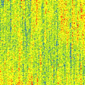
25 3-D land acquisition imprints RMS amplitude map over a time window 25

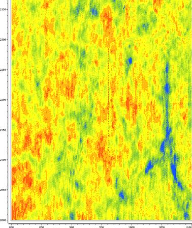
26 3-D marine data: input section 26

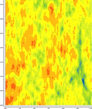
27 3-D marine data: output section 27


28 Outline Introduction Variogram and Autocorrelation Factorial Kriging Factorial Co-kriging Standard approach An automatic approach Application of Factorial Kriging to 3-D seismic Filtering acquisition and processing imprints Application of Factorial Co-kriging to 4-D seismic Filtering 3-D velocity cubes Pre-stack filtering for amplitude balancing 28


29 3-D velocity co-filtering Survey 1 Common part Survey 2 29


30 Pre-stack factorial co-kriging offset 01 offset 03 30


31 Pre-stack filtering for time-lapse From RMS amplitude map over a time window for one offset Variograms cross 98-cross Not to scale 01-cross Not to scale 31
32 Pre-stack filtering for time-lapse Correlation between surveys vs. offset Correlation between surveys 0,80 Correlation Coefficient 0,75 0,70 0,65 0,60 0,55 0, Offset Rho 32
33 Pre-stack filtering for time-lapse RMS amplitude variation coefficient (dispersion) vs. offset 0,35 Variation Coefficient 0,25 0,15 0, Offset Survey1 Survey2 AFACK 33

34 What happens to 4-D signature? Post-stack automatic Factorial Co-kriging. RMS amplitude and Time filtering. Difference before Difference after 34


35 Conclusions Balancing surveys Extraction of a common part, a better candidate for a reference than any of the surveys Removing spatially uncorrelated variations Reducing random noise and organised noise level Removing spatially organised but uncorrelated variations Providing spatial repeatability measurement An efficient algorithm Automated, applicable to large pre-stack data sets Not limited to 2-D maps (e.g. 3-D velocity cubes) Not limited to 2 vintages A CGG patented process targeted to 4-D 35
Geostatistics for Seismic Data Integration in Earth Models
 2003 Distinguished Instructor Short Course Distinguished Instructor Series, No. 6 sponsored by the Society of Exploration Geophysicists European Association of Geoscientists & Engineers SUB Gottingen 7
Kriging Luc Anselin, All Rights Reserved
 Kriging Luc Anselin Spatial Analysis Laboratory Dept. Agricultural and Consumer Economics University of Illinois, Urbana-Champaign http://sal.agecon.uiuc.edu Outline Principles Kriging Models Spatial Interpolation
Stochastic vs Deterministic Pre-stack Inversion Methods. Brian Russell
 Stochastic vs Deterministic Pre-stack Inversion Methods Brian Russell Introduction Seismic reservoir analysis techniques utilize the fact that seismic amplitudes contain information about the geological
Porosity prediction using cokriging with multiple secondary datasets
 Cokriging with Multiple Attributes Porosity prediction using cokriging with multiple secondary datasets Hong Xu, Jian Sun, Brian Russell, Kris Innanen ABSTRACT The prediction of porosity is essential for
Index. Geostatistics for Environmental Scientists, 2nd Edition R. Webster and M. A. Oliver 2007 John Wiley & Sons, Ltd. ISBN:
 Index Akaike information criterion (AIC) 105, 290 analysis of variance 35, 44, 127 132 angular transformation 22 anisotropy 59, 99 affine or geometric 59, 100 101 anisotropy ratio 101 exploring and displaying
RC 2.7. Main Menu. SEG/Houston 2005 Annual Meeting 1355
 Thierry Coléou, Fabien Allo and Raphaël Bornard, CGG; Jeff Hamman and Don Caldwell, Marathon Oil Summary We present a seismic inversion method driven by a petroelastic model, providing fine-scale geological
Fracture characterization from scattered energy: A case study
 Fracture characterization from scattered energy: A case study Samantha Grandi K., Sung Yuh, Mark E. Willis, and M. Nafi Toksöz Earth Resources Laboratory, MIT. Cambridge, MA. Total Exploration & Production.
Stochastic Seismic Signal Processing DIGEST
 Stochastic Seismic Signal Processing DIGEST Arben Shtuka and Luc Sandjivy (Seisquare) SUMMARY 1. INTRODUCTION... 4 1.1. Deterministic and Stochastic Signal processing... 4 1.2. Probability Models for processing
23855 Rock Physics Constraints on Seismic Inversion
 23855 Rock Physics Constraints on Seismic Inversion M. Sams* (Ikon Science Ltd) & D. Saussus (Ikon Science) SUMMARY Seismic data are bandlimited, offset limited and noisy. Consequently interpretation of
Earth models for early exploration stages
 ANNUAL MEETING MASTER OF PETROLEUM ENGINEERING Earth models for early exploration stages Ângela Pereira PhD student angela.pereira@tecnico.ulisboa.pt 3/May/2016 Instituto Superior Técnico 1 Outline Motivation
Reservoir connectivity uncertainty from stochastic seismic inversion Rémi Moyen* and Philippe M. Doyen (CGGVeritas)
") Rémi Moyen* and Philippe M. Doyen (CGGVeritas) Summary Static reservoir connectivity analysis is sometimes based on 3D facies or geobody models defined by combining well data and inverted seismic impedances.
Rémi Moyen* and Philippe M. Doyen (CGGVeritas) Summary Static reservoir connectivity analysis is sometimes based on 3D facies or geobody models defined by combining well data and inverted seismic impedances.
A021 Petrophysical Seismic Inversion for Porosity and 4D Calibration on the Troll Field
 A021 Petrophysical Seismic Inversion for Porosity and 4D Calibration on the Troll Field T. Coleou* (CGG), A.J. van Wijngaarden (Hydro), A. Norenes Haaland (Hydro), P. Moliere (Hydro), R. Ona (Hydro) &
Updating the low-frequency model in time-lapse seismic inversion: A case study from a heavy-oil steam-injection project
 Updating the low-frequency model in time-lapse seismic inversion: A case study from a heavy-oil steam-injection project Peter R. Mesdag 1, M. Reza Saberi 1, and Cheran Mangat 2 Abstract A workflow to update
Contents 1 Introduction 2 Statistical Tools and Concepts
 1 Introduction... 1 1.1 Objectives and Approach... 1 1.2 Scope of Resource Modeling... 2 1.3 Critical Aspects... 2 1.3.1 Data Assembly and Data Quality... 2 1.3.2 Geologic Model and Definition of Estimation
Optimal Interpolation
 Optimal Interpolation Optimal Interpolation and/or kriging consist in determining the BEST LINEAR ESTIMATE in the least square sense for locations xi where you have no measurements: Example 1: Collected
3D geostatistical porosity modelling: A case study at the Saint-Flavien CO 2 storage project
 3D geostatistical porosity modelling: A case study at the Saint-Flavien CO 2 storage project Maxime Claprood Institut national de la recherche scientifique, Québec, Canada Earth Modelling 2013 October
A Short Note on the Proportional Effect and Direct Sequential Simulation
 A Short Note on the Proportional Effect and Direct Sequential Simulation Abstract B. Oz (boz@ualberta.ca) and C. V. Deutsch (cdeutsch@ualberta.ca) University of Alberta, Edmonton, Alberta, CANADA Direct
Geostatistics for Gaussian processes
 Introduction Geostatistical Model Covariance structure Cokriging Conclusion Geostatistics for Gaussian processes Hans Wackernagel Geostatistics group MINES ParisTech http://hans.wackernagel.free.fr Kernels
A MultiGaussian Approach to Assess Block Grade Uncertainty
 A MultiGaussian Approach to Assess Block Grade Uncertainty Julián M. Ortiz 1, Oy Leuangthong 2, and Clayton V. Deutsch 2 1 Department of Mining Engineering, University of Chile 2 Department of Civil &
PRODUCING PROBABILITY MAPS TO ASSESS RISK OF EXCEEDING CRITICAL THRESHOLD VALUE OF SOIL EC USING GEOSTATISTICAL APPROACH
 PRODUCING PROBABILITY MAPS TO ASSESS RISK OF EXCEEDING CRITICAL THRESHOLD VALUE OF SOIL EC USING GEOSTATISTICAL APPROACH SURESH TRIPATHI Geostatistical Society of India Assumptions and Geostatistical Variogram
11/8/2018. Spatial Interpolation & Geostatistics. Kriging Step 1
 (Z i Z j ) 2 / 2 (Z i Zj) 2 / 2 Semivariance y 11/8/2018 Spatial Interpolation & Geostatistics Kriging Step 1 Describe spatial variation with Semivariogram Lag Distance between pairs of points Lag Mean
QUANTITATIVE INTERPRETATION
 QUANTITATIVE INTERPRETATION THE AIM OF QUANTITATIVE INTERPRETATION (QI) IS, THROUGH THE USE OF AMPLITUDE ANALYSIS, TO PREDICT LITHOLOGY AND FLUID CONTENT AWAY FROM THE WELL BORE This process should make
Gridding of precipitation and air temperature observations in Belgium. Michel Journée Royal Meteorological Institute of Belgium (RMI)
") Gridding of precipitation and air temperature observations in Belgium Michel Journée Royal Meteorological Institute of Belgium (RMI) Gridding of meteorological data A variety of hydrologic, ecological,
Gridding of precipitation and air temperature observations in Belgium Michel Journée Royal Meteorological Institute of Belgium (RMI) Gridding of meteorological data A variety of hydrologic, ecological,
Statistical Rock Physics
 Statistical - Introduction Book review 3.1-3.3 Min Sun March. 13, 2009 Outline. What is Statistical. Why we need Statistical. How Statistical works Statistical Rock physics Information theory Statistics
Statistícal Methods for Spatial Data Analysis
 Texts in Statistícal Science Statistícal Methods for Spatial Data Analysis V- Oliver Schabenberger Carol A. Gotway PCT CHAPMAN & K Contents Preface xv 1 Introduction 1 1.1 The Need for Spatial Analysis
COLLOCATED CO-SIMULATION USING PROBABILITY AGGREGATION
 COLLOCATED CO-SIMULATION USING PROBABILITY AGGREGATION G. MARIETHOZ, PH. RENARD, R. FROIDEVAUX 2. CHYN, University of Neuchâtel, rue Emile Argand, CH - 2009 Neuchâtel, Switzerland 2 FSS Consultants, 9,
Spatial Interpolation & Geostatistics
 (Z i Z j ) 2 / 2 Spatial Interpolation & Geostatistics Lag Lag Mean Distance between pairs of points 1 y Kriging Step 1 Describe spatial variation with Semivariogram (Z i Z j ) 2 / 2 Point cloud Map 3
Multiple realizations: Model variance and data uncertainty
 Stanford Exploration Project, Report 108, April 29, 2001, pages 1?? Multiple realizations: Model variance and data uncertainty Robert G. Clapp 1 ABSTRACT Geophysicists typically produce a single model,
Quantitative Seismic Interpretation An Earth Modeling Perspective
 Quantitative Seismic Interpretation An Earth Modeling Perspective Damien Thenin*, RPS, Calgary, AB, Canada TheninD@rpsgroup.com Ron Larson, RPS, Calgary, AB, Canada LarsonR@rpsgroup.com Summary Earth models
Improving the quality of Velocity Models and Seismic Images. Alice Chanvin-Laaouissi
 Improving the quality of Velocity Models and Seismic Images Alice Chanvin-Laaouissi 2015, 2015, PARADIGM. PARADIGM. ALL RIGHTS ALL RIGHTS RESERVED. RESERVED. Velocity Volumes Challenges 1. Define sealed
3D geologic modelling of channellized reservoirs: applications in seismic attribute facies classification
 first break volume 23, December 2005 technology feature 3D geologic modelling of channellized reservoirs: applications in seismic attribute facies classification Renjun Wen, * president and CEO, Geomodeling
GEOSTATISTICS. Dr. Spyros Fountas
 GEOSTATISTICS Dr. Spyros Fountas Northing (m) 140550 140450 140350 Trent field Disturbed area Andover 140250 Panholes 436950 437050 437150 437250 437350 Easting (m) Trent Field Westover Farm (Blackmore,
Principles of 3-D Seismic Interpretation and Applications
 Principles of 3-D Seismic Interpretation and Applications Instructor: Dominique AMILHON Duration: 5 days Level: Intermediate-Advanced Course Description This course delivers techniques related to practical
ArcGIS for Geostatistical Analyst: An Introduction. Steve Lynch and Eric Krause Redlands, CA.
 ArcGIS for Geostatistical Analyst: An Introduction Steve Lynch and Eric Krause Redlands, CA. Outline - What is geostatistics? - What is Geostatistical Analyst? - Spatial autocorrelation - Geostatistical
Multivariate Geostatistics
 Hans Wackernagel Multivariate Geostatistics An Introduction with Applications Third, completely revised edition with 117 Figures and 7 Tables Springer Contents 1 Introduction A From Statistics to Geostatistics
Subsurface Consultancy Services
 Subsurface Consultancy Services Porosity from Reservoir Modeling Perspective Arnout Everts with contributions by Peter Friedinger and Laurent Alessio FESM June 2011 LEAP Energy Main Office: G-Tower, level
Advanced analysis and modelling tools for spatial environmental data. Case study: indoor radon data in Switzerland
 EnviroInfo 2004 (Geneva) Sh@ring EnviroInfo 2004 Advanced analysis and modelling tools for spatial environmental data. Case study: indoor radon data in Switzerland Mikhail Kanevski 1, Michel Maignan 1
Lecture 9: Introduction to Kriging
 Lecture 9: Introduction to Kriging Math 586 Beginning remarks Kriging is a commonly used method of interpolation (prediction) for spatial data. The data are a set of observations of some variable(s) of
Spatial Data Analysis in Archaeology Anthropology 589b. Kriging Artifact Density Surfaces in ArcGIS
 Spatial Data Analysis in Archaeology Anthropology 589b Fraser D. Neiman University of Virginia 2.19.07 Spring 2007 Kriging Artifact Density Surfaces in ArcGIS 1. The ingredients. -A data file -- in.dbf
The Proportional Effect of Spatial Variables
 The Proportional Effect of Spatial Variables J. G. Manchuk, O. Leuangthong and C. V. Deutsch Centre for Computational Geostatistics, Department of Civil and Environmental Engineering University of Alberta
adaptive prior information and Bayesian Partition Modelling.
 Beyond kriging - Dealing with discontinuous spatial data fields using adaptive prior information and Bayesian Partition Modelling. John Stephenson 1 (john.stephenson@imperial.ac.uk), K. Gallagher 1 and
Spatial Backfitting of Roller Measurement Values from a Florida Test Bed
 Spatial Backfitting of Roller Measurement Values from a Florida Test Bed Daniel K. Heersink 1, Reinhard Furrer 1, and Mike A. Mooney 2 1 Institute of Mathematics, University of Zurich, CH-8057 Zurich 2
Space-time data. Simple space-time analyses. PM10 in space. PM10 in time
 Space-time data Observations taken over space and over time Z(s, t): indexed by space, s, and time, t Here, consider geostatistical/time data Z(s, t) exists for all locations and all times May consider
Basics in Geostatistics 2 Geostatistical interpolation/estimation: Kriging methods. Hans Wackernagel. MINES ParisTech.
 Basics in Geostatistics 2 Geostatistical interpolation/estimation: Kriging methods Hans Wackernagel MINES ParisTech NERSC April 2013 http://hans.wackernagel.free.fr Basic concepts Geostatistics Hans Wackernagel
ENVIRONMENTAL DATA ANALYSIS WILLIAM MENKE JOSHUA MENKE WITH MATLAB COPYRIGHT 2011 BY ELSEVIER, INC. ALL RIGHTS RESERVED.
 ENVIRONMENTAL DATA ANALYSIS WITH MATLAB WILLIAM MENKE PROFESSOR OF EARTH AND ENVIRONMENTAL SCIENCE COLUMBIA UNIVERSITY JOSHUA MENKE SOFTWARE ENGINEER JOM ASSOCIATES COPYRIGHT 2011 BY ELSEVIER, INC. ALL
HampsonRussell. A comprehensive suite of reservoir characterization tools. cgg.com/geosoftware
 HampsonRussell A comprehensive suite of reservoir characterization tools cgg.com/geosoftware HampsonRussell Software World-class geophysical interpretation HampsonRussell Software is a comprehensive suite
Climate Change: the Uncertainty of Certainty
 Climate Change: the Uncertainty of Certainty Reinhard Furrer, UZH JSS, Geneva Oct. 30, 2009 Collaboration with: Stephan Sain - NCAR Reto Knutti - ETHZ Claudia Tebaldi - Climate Central Ryan Ford, Doug
Spatial statistics, addition to Part I. Parameter estimation and kriging for Gaussian random fields
 Spatial statistics, addition to Part I. Parameter estimation and kriging for Gaussian random fields 1 Introduction Jo Eidsvik Department of Mathematical Sciences, NTNU, Norway. (joeid@math.ntnu.no) February
Quantitative Interpretation
 Quantitative Interpretation The aim of quantitative interpretation (QI) is, through the use of amplitude analysis, to predict lithology and fluid content away from the well bore. This process should make
Handbook of Spatial Statistics Chapter 2: Continuous Parameter Stochastic Process Theory by Gneiting and Guttorp
 Handbook of Spatial Statistics Chapter 2: Continuous Parameter Stochastic Process Theory by Gneiting and Guttorp Marcela Alfaro Córdoba August 25, 2016 NCSU Department of Statistics Continuous Parameter
W041 Faults and Fracture Detection based on Seismic Surface Orthogonal Decomposition
 W041 Faults and Fracture Detection based on Seismic Surface Orthogonal Decomposition I.I. Priezzhev (Schlumberger Information Solution) & A. Scollard* (Schlumberger Information Solution) SUMMARY A new
Toward an Integrated and Realistic Interpretation of Continuous 4D Seismic Data for a CO 2 EOR and Sequestration Project
 SPE-183789-MS Toward an Integrated and Realistic Interpretation of Continuous 4D Seismic Data for a CO 2 EOR and Sequestration Project Philippe Nivlet, Robert Smith, Michael A. Jervis, and Andrey Bakulin,
Geostatistics in Hydrology: Kriging interpolation
 Chapter Geostatistics in Hydrology: Kriging interpolation Hydrologic properties, such as rainfall, aquifer characteristics (porosity, hydraulic conductivity, transmissivity, storage coefficient, etc.),
Fred Mayer 1; Graham Cain 1; Carmen Dumitrescu 2; (1) Devon Canada; (2) Terra-IQ Ltd. Summary
 Devon Canada; (2) Terra-IQ Ltd. Summary") 2401377 Statistically Improved Resistivity and Density Estimation From Multicomponent Seismic Data: Case Study from the Lower Cretaceous McMurray Formation, Athabasca Oil Sands Fred Mayer 1; Graham Cain
2401377 Statistically Improved Resistivity and Density Estimation From Multicomponent Seismic Data: Case Study from the Lower Cretaceous McMurray Formation, Athabasca Oil Sands Fred Mayer 1; Graham Cain
Time-Lapse Seismic: A Geophysicist s Perspective. Rob Staples Shell E & P Europe. SPE / EAGE workshop Copenhagen, March 2004
 Time-Lapse Seismic: A Geophysicist s Perspective Rob Staples Shell E & P Europe SPE / EAGE workshop Copenhagen, March 2004 1. What do we observe? 2. Noise and detectability 3. Resolution, scale, interference
Multiple realizations using standard inversion techniques a
 Multiple realizations using standard inversion techniques a a Published in SEP report, 105, 67-78, (2000) Robert G Clapp 1 INTRODUCTION When solving a missing data problem, geophysicists and geostatisticians
Traps for the Unwary Subsurface Geoscientist
 Traps for the Unwary Subsurface Geoscientist ashley.francis@sorviodvnvm.co.uk http://www.sorviodvnvm.co.uk Presented at SEG Development & Production Forum, 24-29 th June 2001, Taos, New Mexico, USA 24-29
ENGRG Introduction to GIS
 ENGRG 59910 Introduction to GIS Michael Piasecki October 13, 2017 Lecture 06: Spatial Analysis Outline Today Concepts What is spatial interpolation Why is necessary Sample of interpolation (size and pattern)
Analytical Methods. Session 3: Statistics II. UCL Department of Civil, Environmental & Geomatic Engineering. Analytical Methods.
 Analytical Methods Session 3: Statistics II More statistical tests Quite a few more questions that we might want to ask about data that we have. Is one value significantly different to the rest, or to
COLLOCATED CO-SIMULATION USING PROBABILITY AGGREGATION
 COLLOCATED CO-SIMULATION USING PROBABILITY AGGREGATION G. MARIETHOZ, PH. RENARD, R. FROIDEVAUX 2. CHYN, University of Neuchâtel, rue Emile Argand, CH - 2009 Neuchâtel, Switzerland 2 FSS Consultants, 9,
Reliability of Seismic Data for Hydrocarbon Reservoir Characterization
 Reliability of Seismic Data for Hydrocarbon Reservoir Characterization Geetartha Dutta (gdutta@stanford.edu) December 10, 2015 Abstract Seismic data helps in better characterization of hydrocarbon reservoirs.
X t = a t + r t, (7.1)
") Chapter 7 State Space Models 71 Introduction State Space models, developed over the past 10 20 years, are alternative models for time series They include both the ARIMA models of Chapters 3 6 and the Classical
Chapter 7 State Space Models 71 Introduction State Space models, developed over the past 10 20 years, are alternative models for time series They include both the ARIMA models of Chapters 3 6 and the Classical
Spatial Analysis II. Spatial data analysis Spatial analysis and inference
 Spatial Analysis II Spatial data analysis Spatial analysis and inference Roadmap Spatial Analysis I Outline: What is spatial analysis? Spatial Joins Step 1: Analysis of attributes Step 2: Preparing for
PETROLEUM GEOSCIENCES GEOLOGY OR GEOPHYSICS MAJOR
 PETROLEUM GEOSCIENCES GEOLOGY OR GEOPHYSICS MAJOR APPLIED GRADUATE STUDIES Geology Geophysics GEO1 Introduction to the petroleum geosciences GEO2 Seismic methods GEO3 Multi-scale geological analysis GEO4
Modeling of Atmospheric Effects on InSAR Measurements With the Method of Stochastic Simulation
 Modeling of Atmospheric Effects on InSAR Measurements With the Method of Stochastic Simulation Z. W. LI, X. L. DING Department of Land Surveying and Geo-Informatics, Hong Kong Polytechnic University, Hung
Applied Geostatisitcs Analysis for Reservoir Characterization Based on the SGeMS (Stanford
 Open Journal of Yangtze Gas and Oil, 2017, 2, 45-66 http://www.scirp.org/journal/ojogas ISSN Online: 2473-1900 ISSN Print: 2473-1889 Applied Geostatisitcs Analysis for Reservoir Characterization Based
Stanford Exploration Project, Report 105, September 5, 2000, pages 41 53
 Stanford Exploration Project, Report 105, September 5, 2000, pages 41 53 40 Stanford Exploration Project, Report 105, September 5, 2000, pages 41 53 Short Note Multiple realizations using standard inversion
Bayesian Transgaussian Kriging
 1 Bayesian Transgaussian Kriging Hannes Müller Institut für Statistik University of Klagenfurt 9020 Austria Keywords: Kriging, Bayesian statistics AMS: 62H11,60G90 Abstract In geostatistics a widely used
Models for spatial data (cont d) Types of spatial data. Types of spatial data (cont d) Hierarchical models for spatial data
 Types of spatial data. Types of spatial data (cont d) Hierarchical models for spatial data") Hierarchical models for spatial data Based on the book by Banerjee, Carlin and Gelfand Hierarchical Modeling and Analysis for Spatial Data, 2004. We focus on Chapters 1, 2 and 5. Geo-referenced data arise
Hierarchical models for spatial data Based on the book by Banerjee, Carlin and Gelfand Hierarchical Modeling and Analysis for Spatial Data, 2004. We focus on Chapters 1, 2 and 5. Geo-referenced data arise
GIST 4302/5302: Spatial Analysis and Modeling
 GIST 4302/5302: Spatial Analysis and Modeling Review Guofeng Cao www.gis.ttu.edu/starlab Department of Geosciences Texas Tech University guofeng.cao@ttu.edu Spring 2016 Course Outlines Spatial Point Pattern
IJMGE Int. J. Min. & Geo-Eng. Vol.49, No.1, June 2015, pp
 IJMGE Int. J. Min. & Geo-Eng. Vol.49, No.1, June 2015, pp.131-142 Joint Bayesian Stochastic Inversion of Well Logs and Seismic Data for Volumetric Uncertainty Analysis Moslem Moradi 1, Omid Asghari 1,
2.6 Two-dimensional continuous interpolation 3: Kriging - introduction to geostatistics. References - geostatistics. References geostatistics (cntd.
 .6 Two-dimensional continuous interpolation 3: Kriging - introduction to geostatistics Spline interpolation was originally developed or image processing. In GIS, it is mainly used in visualization o spatial
Acceptable Ergodic Fluctuations and Simulation of Skewed Distributions
 Acceptable Ergodic Fluctuations and Simulation of Skewed Distributions Oy Leuangthong, Jason McLennan and Clayton V. Deutsch Centre for Computational Geostatistics Department of Civil & Environmental Engineering
Geostatistics for radiological characterization: overview and application cases
 Geostatistics for radiological characterization: overview and application cases Yvon DESNOYERS a* a GEOVARIANCES, 49bis av. Franklin Roosevelt, 77215 Avon, France *corresponding author: yvon.desnoyers@geovariances.com
Geostatistical characterisation of contaminated metals: methodology and illustrations
 1 Geostatistical characterisation of contaminated metals: methodology and illustrations Per Lidar and Arne Larsson, Studsvik Nuclear AB Yvon Desnoyers, Geovariances Symp. on Recycling of Metals arising
Sequential Simulations of Mixed Discrete-Continuous Properties: Sequential Gaussian Mixture Simulation
 Sequential Simulations of Mixed Discrete-Continuous Properties: Sequential Gaussian Mixture Simulation Dario Grana, Tapan Mukerji, Laura Dovera, and Ernesto Della Rossa Abstract We present here a method
Anomaly Density Estimation from Strip Transect Data: Pueblo of Isleta Example
 Anomaly Density Estimation from Strip Transect Data: Pueblo of Isleta Example Sean A. McKenna, Sandia National Laboratories Brent Pulsipher, Pacific Northwest National Laboratory May 5 Distribution Statement
3D and 4D Seismic Data Integration for Geomodel Infilling: A Deep Offshore Turbiditic Field Case Study.
 IPTC-18306-MS 3D and 4D Seismic Data Integration for Geomodel Infilling: A Deep Offshore Turbiditic Field Case Study. V. Silva, T. Cadoret, L.Bergamo, and R.Brahmantio, TOTAL E&P France Copyright 2015,
Beta-Binomial Kriging: An Improved Model for Spatial Rates
 Available online at www.sciencedirect.com ScienceDirect Procedia Environmental Sciences 27 (2015 ) 30 37 Spatial Statistics 2015: Emerging Patterns - Part 2 Beta-Binomial Kriging: An Improved Model for
Analysis of the Pattern Correlation between Time Lapse Seismic Amplitudes and Saturation
 Analysis of the Pattern Correlation between Time Lapse Seismic Amplitudes and Saturation Darkhan Kuralkhanov and Tapan Mukerji Department of Energy Resources Engineering Stanford University Abstract The
Fifteenth International Congress of the Brazilian Geophysical Society. Copyright 2017, SBGf - Sociedade Brasileira de Geofísica
 Geostatistical Reservoir Characterization in Barracuda Field, Campos Basin: A case study Frank Pereira (CGG)*, Ted Holden (CGG), Mohammed Ibrahim (CGG) and Eduardo Porto (CGG). Copyright 2017, SBGf - Sociedade
Chapter 4 - Fundamentals of spatial processes Lecture notes
 TK4150 - Intro 1 Chapter 4 - Fundamentals of spatial processes Lecture notes Odd Kolbjørnsen and Geir Storvik January 30, 2017 STK4150 - Intro 2 Spatial processes Typically correlation between nearby sites
METHODOLOGY WHICH APPLIES GEOSTATISTICS TECHNIQUES TO THE TOPOGRAPHICAL SURVEY
 International Journal of Computer Science and Applications, 2008, Vol. 5, No. 3a, pp 67-79 Technomathematics Research Foundation METHODOLOGY WHICH APPLIES GEOSTATISTICS TECHNIQUES TO THE TOPOGRAPHICAL
Integration of Rock Physics Models in a Geostatistical Seismic Inversion for Reservoir Rock Properties
 Integration of Rock Physics Models in a Geostatistical Seismic Inversion for Reservoir Rock Properties Amaro C. 1 Abstract: The main goal of reservoir modeling and characterization is the inference of
Investigation of Monthly Pan Evaporation in Turkey with Geostatistical Technique
 Investigation of Monthly Pan Evaporation in Turkey with Geostatistical Technique Hatice Çitakoğlu 1, Murat Çobaner 1, Tefaruk Haktanir 1, 1 Department of Civil Engineering, Erciyes University, Kayseri,
Summary STK 4150/9150
 STK4150 - Intro 1 Summary STK 4150/9150 Odd Kolbjørnsen May 22 2017 Scope You are expected to know and be able to use basic concepts introduced in the book. You knowledge is expected to be larger than
Advances in Locally Varying Anisotropy With MDS
 Paper 102, CCG Annual Report 11, 2009 ( 2009) Advances in Locally Varying Anisotropy With MDS J.B. Boisvert and C. V. Deutsch Often, geology displays non-linear features such as veins, channels or folds/faults
University of California, Los Angeles Department of Statistics. Effect of variogram parameters on kriging weights
 University of California, Los Angeles Department of Statistics Statistics C173/C273 Instructor: Nicolas Christou Effect of variogram parameters on kriging weights We will explore in this document how the
Introduction. Semivariogram Cloud
 Introduction Data: set of n attribute measurements {z(s i ), i = 1,, n}, available at n sample locations {s i, i = 1,, n} Objectives: Slide 1 quantify spatial auto-correlation, or attribute dissimilarity
We LHR3 04 Realistic Uncertainty Quantification in Geostatistical Seismic Reservoir Characterization
 We LHR3 04 Realistic Uncertainty Quantification in Geostatistical Seismic Reservoir Characterization A. Moradi Tehrani* (CGG), A. Stallone (Roma Tre University), R. Bornard (CGG) & S. Boudon (CGG) SUMMARY
Recent developments in object modelling opens new era for characterization of fluvial reservoirs
 Recent developments in object modelling opens new era for characterization of fluvial reservoirs Markus L. Vevle 1*, Arne Skorstad 1 and Julie Vonnet 1 present and discuss different techniques applied
Drill-Holes and Blast-Holes
 Drill-Holes and Blast-Holes Serge Antoine Séguret 1 and Sebastian De La Fuente 2 Abstract The following is a geostatistical study of copper measurements on samples from diamond drill-holes and blast-holes.
On dealing with spatially correlated residuals in remote sensing and GIS
 On dealing with spatially correlated residuals in remote sensing and GIS Nicholas A. S. Hamm 1, Peter M. Atkinson and Edward J. Milton 3 School of Geography University of Southampton Southampton SO17 3AT
Downloaded 10/02/18 to Redistribution subject to SEG license or copyright; see Terms of Use at
 Multi-scenario, multi-realization seismic inversion for probabilistic seismic reservoir characterization Kester Waters* and Michael Kemper, Ikon Science Ltd. Summary We propose a two tiered inversion strategy
ELEG 3143 Probability & Stochastic Process Ch. 6 Stochastic Process
 Department of Electrical Engineering University of Arkansas ELEG 3143 Probability & Stochastic Process Ch. 6 Stochastic Process Dr. Jingxian Wu wuj@uark.edu OUTLINE 2 Definition of stochastic process (random
Copyright The McGraw-Hill Companies, Inc. Permission required for reproduction or display.
 Chapter 15. SPATIAL INTERPOLATION 15.1 Elements of Spatial Interpolation 15.1.1 Control Points 15.1.2 Type of Spatial Interpolation 15.2 Global Methods 15.2.1 Trend Surface Models Box 15.1 A Worked Example
Caracterização de. Michelle Uchôa Chaves Geóloga SIS Brasil
 Caracterização de Reservatórios Michelle Uchôa Chaves Geóloga SIS Brasil Email: mchaves@slb.com Introduction into SIS Schlumberger Information Solutions (SIS), an operating unit of Schlumberger, is organized
Point-Referenced Data Models
 Point-Referenced Data Models Jamie Monogan University of Georgia Spring 2013 Jamie Monogan (UGA) Point-Referenced Data Models Spring 2013 1 / 19 Objectives By the end of these meetings, participants should
Introduction to Spatial Data and Models
 Introduction to Spatial Data and Models Sudipto Banerjee 1 and Andrew O. Finley 2 1 Biostatistics, School of Public Health, University of Minnesota, Minneapolis, Minnesota, U.S.A. 2 Department of Forestry
4th HR-HU and 15th HU geomathematical congress Geomathematics as Geoscience Reliability enhancement of groundwater estimations
 Reliability enhancement of groundwater estimations Zoltán Zsolt Fehér 1,2, János Rakonczai 1, 1 Institute of Geoscience, University of Szeged, H-6722 Szeged, Hungary, 2 e-mail: zzfeher@geo.u-szeged.hu