Improving the quality of Velocity Models and Seismic Images. Alice Chanvin-Laaouissi
|
|
|
- Melvin Miles
- 5 years ago
- Views:
Transcription
1 Improving the quality of Velocity Models and Seismic Images Alice Chanvin-Laaouissi 2015, 2015, PARADIGM. PARADIGM. ALL RIGHTS ALL RIGHTS RESERVED. RESERVED.
2 Velocity Volumes Challenges 1. Define sealed 3D framework for velocity interpolation 2. Perform geologically constrained velocity models 3. Update velocity models 2


3 How to define a sealed 3D framework for velocity modeling? By construction SKUA models are built in 3D volumes SKUA models = Sealed models Perfect data carrier for velocity modeling studies 3D framework automatically built with structural model no time loss UVT transform Geologically constrained velocity model 3


4 Creation of geologically constrained velocity models SKUA can model any structural and stratigraphic complexities Framework for velocity modeling is a perfect representation of the geological reality hence reduces uncertainties on time/depth conversion SKUA model in extensive environment, complex fault network SKUA model in compressive environment SKUA Model around intrusive structure SKUA model built around a Salt structure and related velocity model - perfect framework for velocity modeling 4
, allowing noise removal SKUA Geological grid = ideal support for geostatistics")

5 Creation of geologically constrained velocity models Simple to advanced interpolation of velocity: Multiple data input: Stacking velocities, checkshot, sonic, well markers Multiple geostatistical methods (from simple interpolation to kriging with external drift), allowing noise removal SKUA Geological grid = ideal support for geostatistics computation (no cell distorsion) Improved model accuracy by combining different velocity data sources and by using appropriate methods for velocity interpolation along stratigraphy SKUA grid built around a Salt structure and related geologically constrained velocity model Velocity inputs can be interpolated within the SKUA model using various geostatistics methods

 derived from")
6 Example of Velocity model creation from Sonic Logs Import Sonic as well log Display and QC Sonic in Log display On Wells defined velocity log derived from Sonic On Geologic grid use kriging with external drift (hard data= velocity logs) and drift property derived from Depth Conversion law Sonic displayed in Well section Variogram analysis on residuals SKUA model in extensive environment, filled with Sonic derived velocity Velocity law V=f(TWT) derived from Sonic


7 Property model editor to fully take advantage of the SKUA model Various methods available to interpolate velocity on sealed SKUA model Ability to combine multiple velocity inputs and use multiple velocity methods for advanced velocity modeling Easily create multiple velocity models within the same study for better understanding of structural uncertainty Geologically constrained Vint transferred from SKUA model to seismic cube. Co-rendering of seismic amplitude and Vint. Methods: Constant Linear function Exponential function User defined equations Linear Function of Property Interpolated Property From Grid Property From Surface of Layer Boundary Property 7

8 SKUA for tomography 2015, 2015, PARADIGM. PARADIGM. ALL RIGHTS ALL RIGHTS RESERVED. RESERVED. 8


")
9 Goal Use the SKUA structural and stratigraphic model building capabilities in the depth imaging workflow. In particular important in geological regimes defined by faults, salt bodies, unconformities, etc. Background velocity model creation Depth imaging Depth Interpretation Model-building in SKUA (for complex models) Tomography updates/well tie updates 9


")

 patches can be")

10 Paradigm 15: Current Status Horizon and fault picking (3D Canvas)* Epos-link SKUA model creation Grid-based tomography workflow Illumination studies Epos-link Volumes creations (Dip, Az, Formation, Velocity) Tsurfaces (Horizons and Faults) Improvements for grid based tomography and illumination. *Automatic picking of horizon (stratigraphic) patches can be performed to better constrain SKUA Model internal stratigraphic layering style 10
![Support for Volumes In GeoDepth, seamlessly support Attribute Volumes created from SKUA models [epos-link]:](/docs-images/85/91744520/images/11-2.jpg "Velocity Geological formation Dip, Azimuth Volumes exported in 32bit float format No NDVs to match Geodepth")
11 Support for Volumes In GeoDepth, seamlessly support Attribute Volumes created from SKUA models [epos-link]: Velocity Geological formation Dip, Azimuth Volumes exported in 32bit float format No NDVs to match Geodepth requirements 11


12 Dip and Azimuth Volumes New in P15 Dip and Azimuth Cube: Voxet > Compute > SKUA Model Curvature Varying Dip values within conformable stratigraphic layers 12


13 Dip and Azimuth Volumes New in P15 Example with erosions Varying Dip values within eroded stratigraphic layers 13


")


14 Stratigraphic patch extraction Additional automatic picking of horizon (stratigraphic) patches can be performed to better constrain internal stratigraphic layering style of the SKUA model Structural Model Building QC, interpretation and modeling validation Paleospace Computation Seed Generation Patch Propagation Geological Time Computation Geological Grid Building
15 Example of Usages of SKUA Generated Volumes for Tomography 2015, 2015, PARADIGM. PARADIGM. ALL RIGHTS ALL RIGHTS RESERVED. RESERVED. 15


16 Usage of Formation Volume Tomography - Build Matrix, Interactive Ray Tracing Ray filtering by formations relevant for models containing salt bodies. 16

17 Usage of Formation Volume Grid Tomography- Solve Matrix: Final interpolation according to formation volume: Updated volumes better honor the structure. Update limits per formation. Update constraints per formation. Smoothing and sensitivity factors per formation. 17

18 Grid Tomography Interpolation Example Without Formation Volume With Formation Volume 18


19 An example of Salt Model Building Workflow Migration with Sediment Velocity Tomography Update for Sediments Migration and Pick Top of Salt Create Model with Salt flooding + Vel Modeling Grid Tomography With formation volume for filtering rays through salt body Migration and pick bottom of salt Build SKUA MODEL with Salt Grid Tomography using formation volume with no update of salt region 19


20 Inserting Salt Velocity Initial interpretation Related SKUA model and formation volume Pick top of salt Build salt surface with vertical flanks Sediment VINT Updated VINT Use background velocity model for sediment layers (Sediment VINT) Add Salt velocity with property model editor Create new SKUA model including Salt 20

21 Velocity model update with salt Per layer velocity model update 21
22 Advantages Geologically derived Dip/Azimuth volumes Geological formation volume can guide and control the Tomography updates for complex models. Faults and other discontinuities are honored properly in the velocity model to avoid imaging artifacts. Illumination workflow with complex models. 23
23 Paradigm 15.5 and beyond 2015, 2015, PARADIGM. PARADIGM. ALL RIGHTS ALL RIGHTS RESERVED. RESERVED. 24


24 SKUA Model update from Tomography SKUA model update from vertical displacement in pencils


25 SKUA-GeoDepth Integration Plan P15: SKUA Volumes Enhances: Grid-Based Tomography Illumination RTM Modeling P15.5: SKUA Pencils Enhances: Model-Based Tomography workflow P16: Stratigraphic Column P16.5: SKUA Geological (coarse) grid for Tomography 26
26 SKUA-GeoDepth Integration Plan P15.5/P16 P15.5: SKUA Pencils Enhances: Model-Based Tomography workflow Benefits for the user: Pencils can be generated directly in SKUA from SKUA model (P15.5) Model-based Tomography provides updates that fully honors the structure. Use the depth updates to update a SKUA model - Sealed model remain sealed after Tomo iteration 27


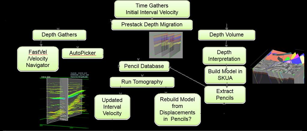
27 Paradigm 15.5: Model-based Tomography Workflow Time Gathers Initial Interval Velocity Prestack Depth Migration Depth Gathers Depth Volume FastVel /Velocity Navigator AutoPicker Pencil Database Run Tomography Depth Interpretation Build Model in SKUA Updated Interval Velocity Rebuild Model from Displacements in Pencils (P16) Extract Pencils 28

28 Thank You 2015, 2015, PARADIGM. PARADIGM. ALL RIGHTS ALL RIGHTS RESERVED. RESERVED.
SeisLink Velocity. Key Technologies. Time-to-Depth Conversion
 Velocity Calibrated Seismic Imaging and Interpretation Accurate Solution for Prospect Depth, Size & Geometry Accurate Time-to-Depth Conversion was founded to provide geologically feasible solutions for
Anisotropic Depth Migration and High-Resolution Tomography in Gulf of Mexico: A Case History
 Anisotropic Depth Migration and High-Resolution Tomography in Gulf of Mexico: A Case History Gary Rodriguez, Sherry Yang, Diane Yang, Quincy Zhang, Steve Hightower, TGS Summary We present a case study
Merging chronostratigraphic modeling and global interpretation Emmanuel Labrunye, Stanislas Jayr, Paradigm
 Emmanuel Labrunye, Stanislas Jayr, Paradigm SUMMRY This paper proposes to combine the automatic interpretation of horizons in a seismic cube and the power of a space/time framework to quickly build an
A Southern North Sea Multi-Survey presdm using Hybrid Gridded Tomography
 A Southern North Sea Multi-Survey presdm using Hybrid Gridded Tomography Ian Jones* GX Technology, Egham, United Kingdom ijones@gxt.com Emma Evans and Darren Judd GX Technology, Egham, United Kingdom and
C031 Quantifying Structural Uncertainty in Anisotropic Depth Imaging - Gulf of Mexico Case Study
 C031 Quantifying Structural Uncertainty in Anisotropic Depth Imaging - Gulf of Mexico Case Study K. Osypov* (WesternGeco), D. Nichols (WesternGeco), Y. Yang (WesternGeco), F. Qiao (WesternGeco), M. O'Briain
G002 An Integrated Regional Framework for Seismic Depth Imaging in the Deepwater Gulf of Mexico
 G002 An Integrated Regional Framework for Seismic Depth Imaging in the Deepwater Gulf of Mexico M. Davidson (Fugro Multi Client Services), M. Leander (Fugro Multi Client Services), K. Mohn (Fugro Multi
Principles of 3-D Seismic Interpretation and Applications
 Principles of 3-D Seismic Interpretation and Applications Instructor: Dominique AMILHON Duration: 5 days Level: Intermediate-Advanced Course Description This course delivers techniques related to practical
Quantitative Seismic Interpretation An Earth Modeling Perspective
 Quantitative Seismic Interpretation An Earth Modeling Perspective Damien Thenin*, RPS, Calgary, AB, Canada TheninD@rpsgroup.com Ron Larson, RPS, Calgary, AB, Canada LarsonR@rpsgroup.com Summary Earth models
Tu N Fault Shadow Removal over Timor Trough Using Broadband Seismic, FWI and Fault Constrained Tomography
 Tu N118 05 Fault Shadow Removal over Timor Trough Using Broadband Seismic, FWI and Fault Constrained Tomography Y. Guo* (CGG), M. Fujimoto (INPEX), S. Wu (CGG) & Y. Sasaki (INPEX) SUMMARY Thrust-complex
Building an Integrated Static Reservoir Model 5-day Course
 Building an Integrated Static Reservoir Model 5-day Course Prepared by International Reservoir Technologies Lakewood, Colorado http://www.irt-inc.com/ 1 Agenda Day 1 Day 2 Day 3 Day 4 Day 5 Morning Introduction
23855 Rock Physics Constraints on Seismic Inversion
 23855 Rock Physics Constraints on Seismic Inversion M. Sams* (Ikon Science Ltd) & D. Saussus (Ikon Science) SUMMARY Seismic data are bandlimited, offset limited and noisy. Consequently interpretation of
Velocity Update Using High Resolution Tomography in Santos Basin, Brazil Lingli Hu and Jianhang Zhou, CGGVeritas
 Lingli Hu and Jianhang Zhou, CGGVeritas Summary The exploration interest in the Santos Basin offshore Brazil has increased with the large deep water pre-salt discoveries, such as Tupi and Jupiter. As the
H005 Pre-salt Depth Imaging of the Deepwater Santos Basin, Brazil
 H005 Pre-salt Depth Imaging of the Deepwater Santos Basin, Brazil Y. Huang* (CGGVeritas), D. Lin (CGGVeritas), B. Bai (CGGVeritas), S. Roby (CGGVeritas) & C. Ricardez (CGGVeritas) SUMMARY Several discoveries,
NEW GEOLOGIC GRIDS FOR ROBUST GEOSTATISTICAL MODELING OF HYDROCARBON RESERVOIRS
 FOR ROBUST GEOSTATISTICAL MODELING OF HYDROCARBON RESERVOIRS EMMANUEL GRINGARTEN, BURC ARPAT, STANISLAS JAYR and JEAN- LAURENT MALLET Paradigm Houston, USA. ABSTRACT Geostatistical modeling of reservoir
The progressive role of Quantitative Seismic Interpretation Unlocking subsurface opportunities From qualitative to quantitative
 The progressive role of Quantitative Seismic Interpretation Unlocking subsurface opportunities From qualitative to quantitative Bruno de Ribet, Technology Global Director Peter Wang, Technical Sales Advisor
Interval anisotropic parameters estimation in a least squares sense Case histories from West Africa
 P-263 Summary Interval anisotropic parameters estimation in a least squares sense Patrizia Cibin*, Maurizio Ferla Eni E&P Division (Milano, Italy), Emmanuel Spadavecchia - Politecnico di Milano (Milano,
Fred Mayer 1; Graham Cain 1; Carmen Dumitrescu 2; (1) Devon Canada; (2) Terra-IQ Ltd. Summary
 Devon Canada; (2) Terra-IQ Ltd. Summary") 2401377 Statistically Improved Resistivity and Density Estimation From Multicomponent Seismic Data: Case Study from the Lower Cretaceous McMurray Formation, Athabasca Oil Sands Fred Mayer 1; Graham Cain
2401377 Statistically Improved Resistivity and Density Estimation From Multicomponent Seismic Data: Case Study from the Lower Cretaceous McMurray Formation, Athabasca Oil Sands Fred Mayer 1; Graham Cain
We Improved Salt Body Delineation Using a new Structure Extraction Workflow
 We-08-08 Improved Salt Body Delineation Using a new Structure Extraction Workflow A. Laake* (WesternGeco) SUMMARY Current salt imaging workflows require thorough geological understanding in the selection
A Petroleum Geologist's Guide to Seismic Reflection
 A Petroleum Geologist's Guide to Seismic Reflection William Ashcroft WILEY-BLACKWELL A John Wiley & Sons, Ltd., Publication Contents Preface Acknowledgements xi xiii Part I Basic topics and 2D interpretation
Depth Imaging for Unconventional Reservoir Characterization: Canadian Plains Case Study
 Depth Imaging for Unconventional Reservoir Characterization: Canadian Plains Case Study Bill Goodway 1, Greg Purdue 1, Shiang Yong Looi 2, Lijuan (Kathy) Du 2, Mark Rowland 2 1 Apache Canada, 2 Schlumberger
Demo Schedule and Abstracts
 2014 Paradigm Technology Roadshow - Brisbane Demo Schedule and Abstracts 11 June 2014 Hilton Hotel Brisbane, Australia www.pdgm.com Location: Brisbane Time Presentation Title Featured Technologies 3:00
Depth Imaging through Surface Carbonates: A 2D example from the Canadian Rocky Mountains
 Depth Imaging through Surface Carbonates: A 2D example from the Canadian Rocky Mountains Yong Hua* University of Calgary, Calgary, AB yhua@ucalgary.ca and Don Lawton University of Calgary, Calgary, AB,
Multiple horizons mapping: A better approach for maximizing the value of seismic data
 Multiple horizons mapping: A better approach for maximizing the value of seismic data Das Ujjal Kumar *, SG(S) ONGC Ltd., New Delhi, Deputed in Ministry of Petroleum and Natural Gas, Govt. of India Email:
Static Corrections for Seismic Reflection Surveys
 Static Corrections for Seismic Reflection Surveys MIKE COX Volume Editors: Series Editor: Eugene F. Scherrer Roland Chen Eugene F. Scherrer Society of Exploration Geophysicists Tulsa, Oklahoma Contents
Tu N Estimation of Uncertainties in Fault Lateral Positioning on 3D PSDM Seismic Image - Example from the NW Australian Shelf
 Tu N118 06 Estimation of Uncertainties in Fault Lateral Positioning on 3D PSDM Seismic Image - Example from the NW Australian Shelf S. Birdus* (CGG), V. Ganivet (CGG), A. Artemov (CGG), R. Teakle (Chevron)
Dip-constrained tomography with weighting flow for paleo-canyons: a case study in Para- Maranhao Basin, Brazil Guang Chen and Lingli Hu, CGG
 Dip-constrained tomography with weighting flow for paleo-canyons: a case study in Para- Maranhao Basin, Brazil Guang Chen and Lingli Hu, CGG Summary Para-Maranhao Basin offshore Brazil is well-known for
An Integrated Workflow for Seismic Data Conditioning and Modern Prestack Inversion Applied to the Odin Field. P.E.Harris, O.I.Frette, W.T.
 An Integrated Workflow for Seismic Data Conditioning and Modern Prestack Inversion Applied to the Odin Field P.E.Harris, O.I.Frette, W.T.Shea Talk Outline Introduction Motivation Introducing Pcube+ Gather
DATA ANALYSIS AND INTERPRETATION
 III. DATA ANALYSIS AND INTERPRETATION 3.1. Rift Geometry Identification Based on recent analysis of modern and ancient rifts, many previous workers concluded that the basic structural unit of continental
Summary. Introduction
 Detailed velocity model building in a carbonate karst zone and improving sub-karst images in the Gulf of Mexico Jun Cai*, Hao Xun, Li Li, Yang He, Zhiming Li, Shuqian Dong, Manhong Guo and Bin Wang, TGS
B033 Improving Subsalt Imaging by Incorporating MT Data in a 3D Earth Model Building Workflow - A Case Study in Gulf of Mexico
 B033 Improving Subsalt Imaging by Incorporating MT Data in a 3D Earth Model Building Workflow - A Case Study in Gulf of Mexico E. Medina* (WesternGeco), A. Lovatini (WesternGeco), F. Golfré Andreasi (WesternGeco),
Velocity model building in complex media by multi-layer non-linear slope tomography. Summary Introduction Non-linear slope tomography
 Velocity model building in complex media by multi-layer non-linear slope tomography. Patrice Guillaume, Jean-Philippe Montel*, Xiaoming Zhang, Gilles Lambaré, Anthony Prescott, Matthieu Reinier, Richard
We A10 12 Common Reflection Angle Migration Revealing the Complex Deformation Structure beneath Forearc Basin in the Nankai Trough
 We A10 12 Common Reflection Angle Migration Revealing the Complex Deformation Structure beneath Forearc Basin in the Nankai Trough K. Shiraishi* (JAMSTEC), M. Robb (Emerson Paradigm), K. Hosgood (Emerson
PROCEEDINGS, INDONESIAN PETROLEUM ASSOCIATION Thirty-Eighth Annual Convention & Exhibition, May 2014
 IPA14-G-227 PROCEEDINGS, INDONESIAN PETROLEUM ASSOCIATION Thirty-Eighth Annual Convention & Exhibition, May 2014 A COMPARISON OF DEPTH CONVERSION METHODS IN BUNTAL GAS FIELD, BLOCK B, NATUNA SEA, INDONESIA
Hybrid Gridded Tomography. Ian F. Jones Mick Sugrue Pierre Hardy. GX Technology, 180 High Street, Egham, Surrey TW20 9DN, UK
 Hybrid Gridded Tomography By Ian F. Jones Mick Sugrue Pierre Hardy GX Technology, 8 High Street, Egham, Surrey TW 9DN, UK First Break V 5 April 7 P5- Corresponding Author Ian F. Jones ijones@gxt.com Hybrid
Bulletin of Earth Sciences of Thailand
 AN INTEGRATED VELOCITY MODELING WORKFLOW TO PREDICT RELIABLE DEPTHS IN TRAT FIELD, GULF OF THAILAND Sarayoot Geena Petroleum Geoscience Program, Department of Geology, Faculty of Science, Chulalongkorn
QUANTITATIVE INTERPRETATION
 QUANTITATIVE INTERPRETATION THE AIM OF QUANTITATIVE INTERPRETATION (QI) IS, THROUGH THE USE OF AMPLITUDE ANALYSIS, TO PREDICT LITHOLOGY AND FLUID CONTENT AWAY FROM THE WELL BORE This process should make
Use of prestack depth migration for improving the accuracy of horizontal drilling in unconventional reservoirs
 Use of prestack depth migration for improving the accuracy of horizontal drilling in unconventional reservoirs Marianne Rauch-Davies 1, Scott Sutherland 1, Michael Bradshaw 2, Jeff Codd 2, and David Kessler
VELOCITY REDUCTION - A POINT IN VELOCITY MODEL BUILDING FOR PRE-STACK KIRCHOFF DEPTH MIGRATION
 Physical Geography; Cartography; Geographic Information Systems & Spatial Planing VELOCITY REDUCTION - A POINT IN VELOCITY MODEL BUILDING FOR PRE-STACK KIRCHOFF DEPTH MIGRATION Dr. Maya Grigorova University
2010 SEG SEG Denver 2010 Annual Meeting
 Anisotropic model building with wells and horizons: Gulf of Mexico case study comparing different approaches Andrey Bakulin*, Olga Zdraveva, Yangjun (Kevin) Liu, Kevin Lyons, WesternGeco/Schlumberger Summary
Using Curvature to Map Faults, Fractures
 Using Curvature to Map Faults, Fractures by SATINDER CHOPRA and KURT J. MARFURT Editor s note: Chopra is with Arcis Corp., Calgary, Canada; Marfurt is with the University of Oklahoma. Both are AAPG members.
Summary. Tomography with geological constraints
 : an alternative solution for resolving of carbonates Olga Zdraveva*, Saeeda Hydal, and Marta Woodward, WesternGeco Summary Carbonates are often present in close proximity to salt in the sedimentary basins
Multiple realizations: Model variance and data uncertainty
 Stanford Exploration Project, Report 108, April 29, 2001, pages 1?? Multiple realizations: Model variance and data uncertainty Robert G. Clapp 1 ABSTRACT Geophysicists typically produce a single model,
SUMMARY ANGLE DECOMPOSITION INTRODUCTION. A conventional cross-correlation imaging condition for wave-equation migration is (Claerbout, 1985)
") Comparison of angle decomposition methods for wave-equation migration Natalya Patrikeeva and Paul Sava, Center for Wave Phenomena, Colorado School of Mines SUMMARY Angle domain common image gathers offer
Comparison of angle decomposition methods for wave-equation migration Natalya Patrikeeva and Paul Sava, Center for Wave Phenomena, Colorado School of Mines SUMMARY Angle domain common image gathers offer
Pre Stack Imaging To Delineate A New Hydrocarbon Play A Case History
 5th Conference & Exposition on Petroleum Geophysics, Hyderabad-2004, India PP 375-379 Pre Stack Imaging To Delineate A New Hydrocarbon Play A Case History D. Srinivas, T.R. Murali Mohan, Ashwani Lamba,
Duplex Wave Migration
 Duplex Wave Migration TetraSeis Inc. 1 A study of vertical heterogeneities using Duplex Wave Migration (DWM) Outline 2 Introduction Background Conventional Method Duplex Wave Migration DWM Method DWM Advantages
Daniele Colombo* Geosystem-WesternGeco, Calgary, AB M.Virgilio Geosystem-WesternGeco, Milan, Italy.
 Seismic Imaging Strategies for Thrust-Belt Exploration: Extended Offsets, Seismic/Gravity/EM simultaneous Joint-Inversion and Anisotropic Gaussian Beam Pre-Stack Depth Migration Daniele Colombo* Geosystem-WesternGeco,
Porosity. Downloaded 09/22/16 to Redistribution subject to SEG license or copyright; see Terms of Use at
 Geostatistical Reservoir Characterization of Deepwater Channel, Offshore Malaysia Trisakti Kurniawan* and Jahan Zeb, Petronas Carigali Sdn Bhd, Jimmy Ting and Lee Chung Shen, CGG Summary A quantitative
Delineating Karst features using Advanced Interpretation
 P-152 Asheesh Singh, Sibam Chakraborty*, Shafique Ahmad Summary We use Amplitude, Instantaneous Phase, Trace Envelope and Dip of Maximum Similarity Attributes as a tool to delineate Karst induced features
2012 SEG SEG Las Vegas 2012 Annual Meeting Page 1
 Wei Huang *, Kun Jiao, Denes Vigh, Jerry Kapoor, David Watts, Hongyan Li, David Derharoutian, Xin Cheng WesternGeco Summary Since the 1990s, subsalt imaging in the Gulf of Mexico (GOM) has been a major
Residual Statics using CSP gathers
 Residual Statics using CSP gathers Xinxiang Li and John C. Bancroft ABSTRACT All the conventional methods for residual statics analysis require normal moveout (NMO) correction applied on the seismic data.
Seismic Guided Drilling: Near Real Time 3D Updating of Subsurface Images and Pore Pressure Model
 IPTC 16575 Seismic Guided Drilling: Near Real Time 3D Updating of Subsurface Images and Pore Pressure Model Chuck Peng, John Dai and Sherman Yang, Schlumberger WesternGeco Copyright 2013, International
HampsonRussell. A comprehensive suite of reservoir characterization tools. cgg.com/geosoftware
 HampsonRussell A comprehensive suite of reservoir characterization tools cgg.com/geosoftware HampsonRussell Software World-class geophysical interpretation HampsonRussell Software is a comprehensive suite
Summary. Introduction
 Multi-layer tomography and its application for improved depth imaging Patrice Guillaume, Steve Hollingworth*, Xiaoming Zhang, Anthony Prescott, Richard Jupp, Gilles Lambaré, Owen Pape, CGGVeritas Summary
Time-lapse filtering and improved repeatability with automatic factorial co-kriging. Thierry Coléou CGG Reservoir Services Massy
 Time-lapse filtering and improved repeatability with automatic factorial co-kriging. Thierry Coléou CGG Reservoir Services Massy 1 Outline Introduction Variogram and Autocorrelation Factorial Kriging Factorial
The 2D/3D i-stats Workflow for Image-Based Near-Surface Modeling for Statics Corrections
 The 2D/3D i-stats Workflow for Image-Based Near-Surface Modeling for Statics Corrections Öz Yilmaz CTO, GeoTomo LLC With the i-stats workflow, you no longer need first-break picking as for traveltime tomography,
Dirty salt velocity inversion: The road to a clearer subsalt image
 GEOPHYSICS. VOL. 76, NO. 5 (SEPTEMBER-OCTOBER 2011); P. WB169 WB174, 8 FIGS. 10.1190/GEO2010-0392.1 Dirty salt velocity inversion: The road to a clearer subsalt image Shuo Ji 1, Tony Huang 1, Kang Fu 2,
Imaging complex structure with crosswell seismic in Jianghan oil field
 INTERPRETER S CORNER Coordinated by Rebecca B. Latimer Imaging complex structure with crosswell seismic in Jianghan oil field QICHENG DONG and BRUCE MARION, Z-Seis, Houston, Texas, U.S. JEFF MEYER, Fusion
Multiattributes and Seismic Interpretation of Offshore Exploratory Block in Bahrain A Case Study
 Multiattributes and Seismic Interpretation of Offshore Exploratory Block in Bahrain A Case Study Suresh Thampi, Aqeel Ahmed, Yahya Al-Ansari, Ali Shehab, Ahmed Fateh, Anindya Ghosh, Ghada Almoulani. The
Seismic Velocities for Pore-Pressure Prediction. Some Case Histories.
 P - 87 Seismic Velocities for Pore-Pressure Prediction. Some Case Histories. Patrizia Cibin*, Luigi Pizzaferri, Mauro Della Martera Eni E&P Division (Milano, Italy) Summary Seismic velocities have long
The coherence cube. MIKE BAHORICH Amoco Corporation Denver, CO. Faults parallel to strike. Conventional amplitude time
 3-D seismic discontinuity for faults and stratigraphic features: The coherence cube MIKE BAHORICH Amoco Corporation Denver, CO STEVE FARMER Amoco Corporation Tulsa, OK Seismic data are usually acquired
Petrel TIPS&TRICKS from SCM
 Petrel TIPS&TRICKS from SCM Knowledge Worth Sharing Fault Model Quality Control Most Petrel projects are faulted. This means that fault models must be built and then checked for accuracy in almost every
Stochastic vs Deterministic Pre-stack Inversion Methods. Brian Russell
 Stochastic vs Deterministic Pre-stack Inversion Methods Brian Russell Introduction Seismic reservoir analysis techniques utilize the fact that seismic amplitudes contain information about the geological
Caracterização de. Michelle Uchôa Chaves Geóloga SIS Brasil
 Caracterização de Reservatórios Michelle Uchôa Chaves Geóloga SIS Brasil Email: mchaves@slb.com Introduction into SIS Schlumberger Information Solutions (SIS), an operating unit of Schlumberger, is organized
Time vs depth in a North Sea case study of the ugly truth Abstract
 Time vs depth in a North Sea case study of the ugly truth Thomas Massip 1, Lauren Braidwood 1, Juergen Fruehn 1, Owen Isaac 1, Jonathan Denly 1, Robert Richardson 2, Phil Mollicone 3 1 ION Geophysical;
Modeling Optimizes Asset Performance By Chad Baillie
 MARCH 2016 The Better Business Publication Serving the Exploration / Drilling / Production Industry Modeling Optimizes Asset Performance By Chad Baillie MISSOURI CITY, TX. As more well and completion data
An Integrated approach for faults and fractures delineation with dip and curvature attributes
 10 th Biennial International Conference & Exposition P 265 An Integrated approach for faults and fractures delineation with dip and curvature attributes Santosh, D.*, Aditi, B., Poonam, K., Priyanka S.,
Use of Geostatistically-constrained Potential Field Inversion and Downhole Drilling to Predict Distribution of Sulphide and Uranium Mineralisation
 Use of Geostatistically-constrained Potential Field Inversion and Downhole Drilling to Predict Distribution of Sulphide and Uranium Mineralisation Matthew Zengerer Talk Outline Introduction Purpose and
Stratimagic. Seismic Facies Classification
 Stratimagic Seismic Facies Classification 1 Stratimagic A truly geological interpretation of seismic data Stratimagic seismic facies maps allow geoscientists to rapidly gain insight into the depositional
Chapter 1. Introduction EARTH MODEL BUILDING
 Chapter 1 Introduction Seismic anisotropy in complex earth subsurface has become increasingly important in seismic imaging due to the increasing offset and azimuth in modern seismic data. To account for
Fracture characterization from scattered energy: A case study
 Fracture characterization from scattered energy: A case study Samantha Grandi K., Sung Yuh, Mark E. Willis, and M. Nafi Toksöz Earth Resources Laboratory, MIT. Cambridge, MA. Total Exploration & Production.
Investigating fault shadows in a normally faulted geology
 Investigating fault shadows in a normally faulted geology Sitamai Ajiduah* and Gary Margrave CREWES, University of Calgary, sajiduah@ucalgary.ca Summary Fault shadow poses a potential development risk
PETROLEUM GEOSCIENCES GEOLOGY OR GEOPHYSICS MAJOR
 PETROLEUM GEOSCIENCES GEOLOGY OR GEOPHYSICS MAJOR APPLIED GRADUATE STUDIES Geology Geophysics GEO1 Introduction to the petroleum geosciences GEO2 Seismic methods GEO3 Multi-scale geological analysis GEO4
Tarek S. Ellaithy 1, Alexander Prexl 1, Nicolas Daynac 2. (1) DEA Egypt Branches, (2) Eliis SAS, France. Introduction
 DEA Egypt Branches, (2) Eliis SAS, France. Introduction") Methodology and results of Nile Delta Messinian-Pliocene Holistic 3D seismic interpretation A case study from the Disouq area, Onshore Nile Delta, Egypt Tarek S. Ellaithy 1, Alexander Prexl 1, Nicolas
Methodology and results of Nile Delta Messinian-Pliocene Holistic 3D seismic interpretation A case study from the Disouq area, Onshore Nile Delta, Egypt Tarek S. Ellaithy 1, Alexander Prexl 1, Nicolas
Applying full-azimuth angle domain imaging to study carbonate reefs at great depths
 Applying full-azimuth angle domain imaging to study carbonate reefs at great depths Bazar Eskozha 1, Marat Aimagambetov 1, Andrey Kondratenko 2, Vladimir Sementsov 2, Vladimir Pankratov 3, Aigule Kuanysheva
3D beam prestack depth migration with examples from around the world
 A Publication of Petroleum Geo-Services Vol. 8 No. 8 August 2008 3D beam prestack depth migration with examples from around the world Introduction In 1999 AGS specialized in 2D seismic depth processing.
INTEGRATED GEOPHYSICAL INTERPRETATION METHODS FOR HYDROCARBON EXPLORATION
 INTEGRATED GEOPHYSICAL INTERPRETATION METHODS FOR HYDROCARBON EXPLORATION Instructor : Kumar Ramachandran 31 July 4 August 2017 Jakarta COURSE OUTLINE The course is aimed at imparting working knowledge
Reservoir connectivity uncertainty from stochastic seismic inversion Rémi Moyen* and Philippe M. Doyen (CGGVeritas)
") Rémi Moyen* and Philippe M. Doyen (CGGVeritas) Summary Static reservoir connectivity analysis is sometimes based on 3D facies or geobody models defined by combining well data and inverted seismic impedances.
Rémi Moyen* and Philippe M. Doyen (CGGVeritas) Summary Static reservoir connectivity analysis is sometimes based on 3D facies or geobody models defined by combining well data and inverted seismic impedances.
Geohazards have a direct impact on the drilling and
 SPECIAL Geohazards SECTION: G e o h a z a r d s A new, fully integrated method for seismic geohazard prediction ahead of the bit while drilling CENGIZ ESMERSOY, ARTURO RAMIREZ, SHARON TEEBENNY, YANGJUN
3D Converted Wave Data Processing A case history
 P-290 3D Converted Wave Data Processing A case history N. B. R. Prasad, ONGC Summary In recent years, there has been a growing interest in shear- wave exploration for hydrocarbons as it facilitates to
Reservoir characterization
 1/15 Reservoir characterization This paper gives an overview of the activities in geostatistics for the Petroleum industry in the domain of reservoir characterization. This description has been simplified
PART A: Short-answer questions (50%; each worth 2%)
") PART A: Short-answer questions (50%; each worth 2%) Your answers should be brief (just a few words) and may be written on these pages if you wish. Remember to hand these pages in with your other exam pages!
PART A: Short-answer questions (50%; each worth 2%) Your answers should be brief (just a few words) and may be written on these pages if you wish. Remember to hand these pages in with your other exam pages!
Stanford Exploration Project, Report 115, May 22, 2004, pages
 Stanford Exploration Project, Report 115, May 22, 2004, pages 249 264 248 Stanford Exploration Project, Report 115, May 22, 2004, pages 249 264 First-order lateral interval velocity estimates without picking
Department of Geosciences M.S. Thesis Proposal
 Department of Geosciences M.S. Thesis Proposal TITLE: Mapping structural and stratigraphic features using azimuthally dependent seismic attributes. Name: Srinivasa Prasad Jyosyula REASEARCH COMMITTEE (Advisor):
3D geostatistical porosity modelling: A case study at the Saint-Flavien CO 2 storage project
 3D geostatistical porosity modelling: A case study at the Saint-Flavien CO 2 storage project Maxime Claprood Institut national de la recherche scientifique, Québec, Canada Earth Modelling 2013 October
Geostatistics for Seismic Data Integration in Earth Models
 2003 Distinguished Instructor Short Course Distinguished Instructor Series, No. 6 sponsored by the Society of Exploration Geophysicists European Association of Geoscientists & Engineers SUB Gottingen 7
Seismic attributes of time-vs. depth-migrated data using self-adaptive window
 Seismic attributes of time-vs. depth-migrated data using self-adaptive window Tengfei Lin*, Bo Zhang, The University of Oklahoma; Zhifa Zhan, Zhonghong Wan, BGP., CNPC; Fangyu Li, Huailai Zhou and Kurt
Constrained Fault Construction
 Constrained Fault Construction Providing realistic interpretations of faults is critical in hydrocarbon and mineral exploration. Faults can act as conduits or barriers to subsurface fluid migration and
ANISOTROPIC PRESTACK DEPTH MIGRATION: AN OFFSHORE AFRICA CASE STUDY
 Copyright 000 by the Society of Exploration Geophysicists ANISOTROPIC PRESTACK DEPTH MIGRATION: AN OFFSHORE AFRICA CASE STUDY Philippe Berthet *, Paul Williamson *, Paul Sexton, Joachim Mispel * * Elf
W011 Full Waveform Inversion for Detailed Velocity Model Building
 W011 Full Waveform Inversion for Detailed Velocity Model Building S. Kapoor* (WesternGeco, LLC), D. Vigh (WesternGeco), H. Li (WesternGeco) & D. Derharoutian (WesternGeco) SUMMARY An accurate earth model
Time to Depth Conversion and Uncertainty Characterization for SAGD Base of Pay in the McMurray Formation, Alberta, Canada*
 Time to Depth Conversion and Uncertainty Characterization for SAGD Base of Pay in the McMurray Formation, Alberta, Canada* Amir H. Hosseini 1, Hong Feng 1, Abu Yousuf 1, and Tony Kay 1 Search and Discovery
Seismic Driven Pore Pressure Prediction
 Seismic Driven Pore Pressure Prediction Joanne Wang 2016, PARADIGM. ALL RIGHTS RESERVED. Today s Topics PPP technology overview Suit-for-purpose seismic velocity analysis A workflow example PPP in 1D and
We A1 12 Method to Generate a Watertight Geological Model Directly From a Seismic Volume
 We A1 12 Method to Generate a Watertight Geological Model Directly From a Seismic Volume F. Pauget (ELIIS), S. Lacaze* (ELIIS) Summary This paper presents a novel method to compute a watertight geological
TOM 2.6. SEG/Houston 2005 Annual Meeting 2581
 Oz Yilmaz* and Jie Zhang, GeoTomo LLC, Houston, Texas; and Yan Shixin, PetroChina, Beijing, China Summary PetroChina conducted a multichannel large-offset 2-D seismic survey in the Yumen Oil Field, Northwest
Geological Expression A New Approach to Volume Interpretation. Gaynor Paton, ffa
 Geological Expression A New Approach to Volume Interpretation Gaynor Paton, ffa The Value of Data Frontier exploration High exploration costs Uncertain returns $$$ Mature basins Marginal Returns Geological
Improving Resolution with Spectral Balancing- A Case study
 P-299 Improving Resolution with Spectral Balancing- A Case study M Fatima, Lavendra Kumar, RK Bhattacharjee, PH Rao, DP Sinha Western Offshore Basin, ONGC, Panvel, Mumbai Summary: The resolution limit
Observations of Azimuthal Anisotropy in Prestack Seismic Data
 Observations of Azimuthal Anisotropy in Prestack Seismic Data David Gray* CGGVeritas, Calgary, AB, Canada dave.gray@cggveritas.com Summary A method for displaying prestack seismic data that highlights
Recent developments in object modelling opens new era for characterization of fluvial reservoirs
 Recent developments in object modelling opens new era for characterization of fluvial reservoirs Markus L. Vevle 1*, Arne Skorstad 1 and Julie Vonnet 1 present and discuss different techniques applied
A seismic reservoir characterization and porosity estimation workflow to support geological model update: pre-salt reservoir case study, Brazil
 A seismic reservoir characterization and porosity estimation workflow to support geological model update: pre-salt reservoir case study, Brazil Laryssa Oliveira 1*, Francis Pimentel 2, Manuel Peiro 1,
Regularizing seismic inverse problems by model reparameterization using plane-wave construction
 GEOPHYSICS, VOL. 71, NO. 5 SEPTEMBER-OCTOBER 2006 ; P. A43 A47, 6 FIGS. 10.1190/1.2335609 Regularizing seismic inverse problems by model reparameterization using plane-wave construction Sergey Fomel 1
Patterns in Geophysical Data and Models
 Patterns in Geophysical Data and Models Jens Tronicke Angewandte Geophysik Institut für Geowissenschaften Universität Potsdam jens@geo.uni-potsdam.de Near-surface geophysics Using geophysical tools to