A Slice of Earth Systems Data & Analytics
|
|
|
- August Watson
- 5 years ago
- Views:
Transcription

1 A Slice of Earth Systems Data & Analytics Dr. Jennifer K. Balch, Director & Assistant Professor Geography, Applied Mathematics, Cooperative Institute for Research in Environmental Sciences, Ecology & Evolutionary Biology, Environmental Studies, Geological Sciences, Institute of Behavioral Science, National Snow and Ice Data Center, and Research Computing Grand Challenge

2 Our Space. Our Future. CU Boulder s Grand Challenge Our world is facing significant issues with a changing environment, increasing populations and limited resources. The intersection of people, resources and our planet is where CU-Boulder can use its expertise in space-based observation and exploration to address our world s most pressing problems.
3 Earth Lab is the next national synthesis center for Earth Systems Science.
4 MISSION STATEMENT To harmonize Earth observations from aerospace platforms and other sources to address scientific challenges in understanding the pace and pattern of global change to help society better manage and adapt.

5 SCIENCE: Understand the Pace and Pattern of Global Change

6 ANALYTICS HUB: Deal with the Data Deluge

7 EDUCATION: Create the Next Generation of Earth Analysts


8 Earth Lab s Analytics Hub: Brian Johnson, Max Joseph, Tim Dunn Foundational capability in tools and expertise to examine Earth observations and related information through data integration and analytics Creating tight collaborations between scientists and experts in data analytics, computing, and visualization Accelerating discovery by creating new tools and helping researchers scale Commitment to open, reproducible science
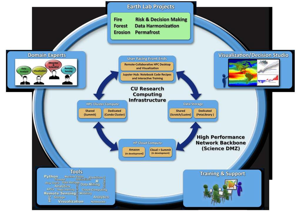
9 Infrastructure


10 Earth Data Analytics Image: Z. Schira Convolutional Neural Networks SMAPR Freepik.com Cloud Compute Solutions DigitalGlobe Partnership
11 Where are the Sweet Spots? Data-Rich Opportunities at the intersection between Climate & Human Health
12 Science Projects: integrate Aerospace data with other data sources to Understand how fire is changing in the U.S. over the past two decades. (Project Fire) Improve risk management and decision-making in land use and hazards mitigation. (Project Risk) Determine the sensitivity of permafrost to a warming Arctic. (Project Permafrost) Identify how rapid and slow landscape evolution impacts our lives. (Project Erosion) Determine what is driving Colorado forest dieback. (Project Forest) Examine how data at varying resolutions represents Earth System phenomena. (Project Data Harmonization) Predict slow and abrupt change, or surprises, across multiple systems. (Project Extremes)


13 Geography Geological Sciences CIRES Environmental Studies Earth Lab NSIDC Applied Math Ecology & Evolutionary Biology IRISS & Aerospace Research Computing

14 Drought Risk How droughts affect ranching insurance Bill Travis, Trisha Shrum, Travis Williams, Max Roland GEOGRAPHY, WESTERN WATER, CIRES


15 Comparing & combining measures of drought risk NOAA/CPC s Gridded Precipitation U.S. Drought Monitor s Drought intensity levels NOAA/ESRL s Evaporative Demand Drought Index (EDDI)


16 Fire How people and climate are changing fires across the U.S. Jennifer Balch, Chelsea Nagy, Nate Mietkiewicz, Lise St. Denis, Adam Mahood, Sepideh Dadashi, Mollie Buckland GEOGRAPHY

17 Project Fire The role of people in U.S. wildfires Balch et al PNAS


18 Project Fire Cost of wildfires where people live Sunshine Canyon Fire, % of all fires started in the WUI are human-caused Mietkiewicz et al. in prep.
 Automated classification of 50+ high-impact megafires")

19 Project Fire Social Impacts of Hazards through Twitter Filtering strategy (St. Denis, 2015) Automated classification of 50+ high-impact megafires Segmentation of conversation Generalizability to other crisis events BLUE CUT FIRE, 2016: 78,000 tweets; 1500 related to smoke and air quality St. Denis et al. in prep.


20 Forests What is driving Colorado forest dieback? Carol Wessman, Megan Cattau, Brian Argrow, Eric Frew, Amy DeCastro, Youngyoung Shen IRISS, ENVIRONMENTAL STUDIES, ECOLOGY, CIRES, AEROSPACE

21 Cattau et al. in prep.


22 Erosion Understanding how extreme rainfall drives landslides Bob Anderson, Greg Tucker, Suzanne Anderson, Matt Rossi GEOLOGICAL SCIENCES, GEOGRAPHY, CIRES
23 Extreme hydro-climatic events (2013 event) 5000 Boulder Creek ( ) 2013 floods 4000 Discharge (cfs) Seasonal Snowmelt Low snowmelt year Rain on snow events 0 1/1/2010 1/1/2011 1/1/2012 1/1/2013 1/1/2014 1/1/2015 Date


24 Geomorphic impacts (2013 event) Triggered > 100 landslides on the hillslopes exhuming 100 s to 1000 s of years of soil production St. Vrain River, CO Also triggered devastating river flooding, river erosion, and deposition impacting mountain and Plains communities Image Credits: Andy Cross (Denver Post)

25 Snowmelt to rainfall generated extremes Rossi et al. in prep.

26 Coupled Extremes Understanding & predicting how droughts, fires, floods, and landslides interact Jennifer Balch, Bill Travis, Ben Livneh, Greg Tucker, and Earth Lab Team, Postdocs, & Grads GEOGRAPHY, GEOLOGICAL SCIENCES, CIRES, ENVIRONMENTAL ENGINEERING

27 Balch et al. in prep.

28 Three or more disturbance types co-occur in 9.1% of the U.S. Balch et al. in prep.

29 Global Change research at CU-Boulder 75 Faculty, across 12 Departments

30 Dr. Jennifer K. Balch Thank you.
31


32 Earth data analytics Machine learning and Computer vision techniques in Earth science research Convolutional Neural Networks for image segment & classification Integrating socioeconomic, social media and unstructured data with geospatial data and imagery Building reproducible, extensible data workflows in the cloud Research in language agnostic tools for data access and manipulation DigitalGlobe s GBDX platform for processing its high resolution imagery for use in scientific research Domain knowledge Remote sensing Computing and visualization Geospatial and temporal statistics Machine learning algorithms Open source software programming High resolution commercial imagery NASA & NOAA Satellite products Airborne Hyperspectral &LiDAR Social media & textual information Model data & geospatial products


33 From data to decisions (Adapted from Peter Fox et al., ESIP Federation Summer Meeting, July 10, 2014)
Earth Lab Post-Doctoral Research and Teaching Scholars at the University of Colorado-Boulder
 Earth Lab Post-Doctoral Research and Teaching Scholars at the University of Colorado-Boulder The Earth Lab initiative, part of the University of Colorado Boulder s Grand Challenge: Our Space, Our Future,
The National Integrated Drought Information System (NIDIS) Moving the Nation from Reactive to Proactive Drought Risk Management
 Moving the Nation from Reactive to Proactive Drought Risk Management") The National Integrated Drought Information System (NIDIS) Moving the Nation from Reactive to Proactive Drought Risk Management CSG-West Annual Meeting Agriculture & Water Committee Snowbird, UT September
The National Integrated Drought Information System (NIDIS) Moving the Nation from Reactive to Proactive Drought Risk Management CSG-West Annual Meeting Agriculture & Water Committee Snowbird, UT September
USGS National Geospatial Program Understanding User Needs. Dick Vraga National Map Liaison for Federal Agencies July 2015
 + USGS National Geospatial Program Understanding User Needs Dick Vraga National Map Liaison for Federal Agencies July 2015 + Topics 2 Background Communities of Use User Surveys National Map Liaisons Partnerships
The known requirements for Arctic climate services
 The known requirements for Arctic climate services based on findings described in STT White paper 8/2015 Johanna Ekman / EC PHORS STT Regional drivers The Arctic region is home to almost four million people
The U.S. National Integrated Drought Information System. Roger S. Pulwarty National Oceanic and Atmospheric Administration USA
 The U.S. National Integrated Drought Information System Roger S. Pulwarty National Oceanic and Atmospheric Administration USA Drought: Weather-climate continuum and adaptation deficits 2010 2011 2012 2015
Physical Geography: Patterns, Processes, and Interactions, Grade 11, University/College Expectations
 Geographic Foundations: Space and Systems SSV.01 explain major theories of the origin and internal structure of the earth; Page 1 SSV.02 demonstrate an understanding of the principal features of the earth
Unit 2: The World in Spatial Terms (Lessons 6-7)
") Unit 2: The World in Spatial Terms (Lessons 6-7) Physical Features of Earth Create Challenges and Opportunities The physical features of Earth create both challenges and opportunities for the people living
Unit 2: The World in Spatial Terms (Lessons 6-7) Physical Features of Earth Create Challenges and Opportunities The physical features of Earth create both challenges and opportunities for the people living
Landslide Hazards: A Stealth Threat to the Nation
 Landslide Hazards: A Stealth Threat to the Nation Sponsored by the Geological Society of America Association of Environmental & Engineering Geologists American Society of Civil Engineers In Cooperation
GIS in Weather and Society
 GIS in Weather and Society Olga Wilhelmi Institute for the Study of Society and Environment National Center for Atmospheric Research WAS*IS November 8, 2005 Boulder, Colorado Presentation Outline GIS basic
Remote Sensing and EO activities at the University of Turku
 Remote Sensing and EO activities at the University of Turku Niina Käyhkö Associate Professor Department of Geography and Geology GEO meeting/syke May 23rd, 2018 Geospatial competence at the University
Eagle Creek Post Fire Erosion Hazard Analysis Using the WEPP Model. John Rogers & Lauren McKinney
 Eagle Creek Post Fire Erosion Hazard Analysis Using the WEPP Model John Rogers & Lauren McKinney Columbia River Gorge at Risk: Using LiDAR and GIS-based predictive modeling for regional-scale erosion susceptibility
Chippewa County Natural Hazards Mitigation Plan
 2014 Chippewa County Natural Hazards Mitigation Plan Prepared for: Chippewa County Office of Emergency Management With the Assistance of: Eastern U.P. Regional Planning & Development Commission April,
GEOGRAPHY (029) CLASS XI ( ) Part A: Fundamentals of Physical Geography. Map and Diagram 5. Part B India-Physical Environment 35 Marks
 CLASS XI ( ) Part A: Fundamentals of Physical Geography. Map and Diagram 5. Part B India-Physical Environment 35 Marks") GEOGRAPHY (029) CLASS XI (207-8) One Theory Paper 70 Marks 3 Hours Part A Fundamentals of Physical Geography 35 Marks Unit-: Geography as a discipline Unit-3: Landforms Unit-4: Climate Unit-5: Water (Oceans)
GEOGRAPHY (029) CLASS XI (207-8) One Theory Paper 70 Marks 3 Hours Part A Fundamentals of Physical Geography 35 Marks Unit-: Geography as a discipline Unit-3: Landforms Unit-4: Climate Unit-5: Water (Oceans)
Drought Impacts in the Southern Great Plains. Mark Shafer University of Oklahoma Norman, OK
 Drought Impacts in the Southern Great Plains Mark Shafer University of Oklahoma Norman, OK Causes of Drought: Large-Scale, Stationary High Pressure Air rotates clockwise around high pressure steers storms
Geography Class XI Fundamentals of Physical Geography Section A Total Periods : 140 Total Marks : 70. Periods Topic Subject Matter Geographical Skills
 Geography Class XI Fundamentals of Physical Geography Section A Total Periods : 140 Total Marks : 70 Sr. No. 01 Periods Topic Subject Matter Geographical Skills Nature and Scope Definition, nature, i)
THE CANADIAN CENTRE FOR CLIMATE MODELLING AND ANALYSIS
 THE CANADIAN CENTRE FOR CLIMATE MODELLING AND ANALYSIS As Canada s climate changes, and weather patterns shift, Canadian climate models provide guidance in an uncertain future. CANADA S CLIMATE IS CHANGING
Geology 101: Earth Processes and Environment
 1 Course Introduction 2 Geology 101: Earth Processes and Environment Syllabus & overview of topics The big challenges Why Geology Matters Dr. Steve Kuehn What is environmental geology? Major Earth systems
Prairie Climate Centre Prairie Climate Atlas. Visualizing Climate Change Projections for the Canadian Prairie Provinces
 Prairie Climate Centre Prairie Climate Atlas Visualizing Climate Change Projections for the Canadian Prairie Provinces Acknowledgements About Us Dr. Danny Blair Dr. Ian Mauro Ryan Smith, MSc Dr. Hank Venema
Geospatial framework for monitoring SDGs/Sendai targets By Shimonti Paul Sr. Assistant Editor Geospatial Media & Communications
 Geospatial framework for monitoring SDGs/Sendai targets By Shimonti Paul Sr. Assistant Editor Geospatial Media & Communications Outline 1. Introduction to Geospatial Media and Communications 2. Geospatial
Spatial Survey of Surface Soil Moisture in a Sub-alpine Watershed
 Spatial Survey of Surface Soil Moisture in a Sub-alpine Watershed Katherine E. Williams M.S. GISc Candidate Department of Geography, University of Denver October 7, 2010 Purpose 2 Introduction to Soil
Space Applications for Disaster Risk Reduction and Sustainable Development
 Space Applications for Disaster Risk Reduction and Sustainable Development Space Applications Section (SAS) ICT and Disaster Risk Reduction Division (IDD) UNESCAP Contents I. RESAP Activities 2016-2017
Observation (EO) & Geomatics in Canada
 & Geomatics in Canada") Innovating to Increase the Impact of Earth Observation (EO) & Geomatics in Canada Natural Resources Canada February 25, 2014 Prashant Shukle, Director General Canada Centre for Mapping and Earth Observation
Innovating to Increase the Impact of Earth Observation (EO) & Geomatics in Canada Natural Resources Canada February 25, 2014 Prashant Shukle, Director General Canada Centre for Mapping and Earth Observation
DANIEL WILSON AND BEN CONKLIN. Integrating AI with Foundation Intelligence for Actionable Intelligence
 DANIEL WILSON AND BEN CONKLIN Integrating AI with Foundation Intelligence for Actionable Intelligence INTEGRATING AI WITH FOUNDATION INTELLIGENCE FOR ACTIONABLE INTELLIGENCE in an arms race for artificial
Scientific research and tools to support management and protection of water supplies from the effects of wildfires
 Scientific research and tools to support management and protection of water supplies from the effects of wildfires Deborah A., Martin, U.S. Geological Survey Managing for Uncertainty and Climatic Variability:
Quenching the Valley s thirst: The connection between Sierra Nevada snowpack & regional water supply
 Quenching the Valley s thirst: The connection between Sierra Nevada snowpack & regional water supply Roger Bales, UC Merced Snow conditions Snow & climate change Research directions Sierra Nevada snow
MiSP Ecology/Pollution Global Warming Worksheet #1, L2 GLOBAL WARMING AND ICE EXTENT
 MiSP Ecology/Pollution Global Warming Worksheet #1, L2 Name Date GLOBAL WARMING AND ICE EXTENT Introduction: Sea ice is found in remote polar oceans. On average, sea ice covers about 25 million square
Shared Knowledge for Decision-Making on Environment and Health Issues in the Arctic
 Shared Knowledge for Decision-Making on Environment and Health Issues in the Arctic RADARSAT Global View of the Arctic Ocean Credit : NASA JPL, University of Alaska - Fairbanks Nancy G. Maynard, Ph.D.
Adapting to Climate Change in Black River First Nation
 Adapting to Climate Change in Black River First Nation Dr. Brian G. Kotak, General Manager -Manitoba Model Forest Jack Johnson, Special Projects Black River First Nation Climate Change & Health Adaptation
TRAITS to put you on the map
 TRAITS to put you on the map Know what s where See the big picture Connect the dots Get it right Use where to say WOW Look around Spread the word Make it yours Finding your way Location is associated with
XXIII CONGRESS OF ISPRS RESOLUTIONS
 XXIII CONGRESS OF ISPRS RESOLUTIONS General Resolutions Resolution 0: Thanks to the Czech Society commends: To congratulate The Czech Society, its president and the Congress Director Lena Halounová, the
Pan-Arctic Digital Elevation Map (Pan-Arctic DEM)
") Memorandum to CAFF Board 07/28/2017 BACKGROUND: Pan-Arctic Digital Elevation Map (Pan-Arctic DEM) ArcticDEM is a National Geospatial-Intelligence Agency (NGA)-National Science Foundation (NSF) publicprivate
Memorandum to CAFF Board 07/28/2017 BACKGROUND: Pan-Arctic Digital Elevation Map (Pan-Arctic DEM) ArcticDEM is a National Geospatial-Intelligence Agency (NGA)-National Science Foundation (NSF) publicprivate
Possible Applications of Deep Neural Networks in Climate and Weather. David M. Hall Assistant Research Professor Dept. Computer Science, CU Boulder
 Possible Applications of Deep Neural Networks in Climate and Weather David M. Hall Assistant Research Professor Dept. Computer Science, CU Boulder Quick overview of climate and weather models Weather models
Threats to the Power System
 Threats to the Power System Energy Risk and Critical Infrastructure Workshop National Conference of State Legislatures William P. Mahoney III Deputy Director, Research Applications Laboratory National
Extremes Events in Climate Change Projections Jana Sillmann
 Extremes Events in Climate Change Projections Jana Sillmann Max Planck Institute for Meteorology International Max Planck Research School on Earth System Modeling Temperature distribution IPCC (2001) Outline
This table connects the content provided by Education Perfect to the NSW Syllabus.
 Education Perfect Geography provides teachers with a wide range of quality, engaging and innovative content to drive positive student learning outcomes. Designed by teachers and written by our in-house
Advanced Image Analysis in Disaster Response
 Advanced Image Analysis in Disaster Response Creating Geographic Knowledge Thomas Harris ITT The information contained in this document pertains to software products and services that are subject to the
Effective Utilization of Synthetic Aperture Radar (SAR) Imagery in Rapid Damage Assessment
 Imagery in Rapid Damage Assessment") Effective Utilization of Synthetic Aperture Radar (SAR) Imagery in Rapid Damage Assessment Case Study Pakistan Floods SUPARCO M. Maisam Raza, Ahmad H. Rabbani SEQUENCE Flood Monitoring using Satellite
Effective Utilization of Synthetic Aperture Radar (SAR) Imagery in Rapid Damage Assessment Case Study Pakistan Floods SUPARCO M. Maisam Raza, Ahmad H. Rabbani SEQUENCE Flood Monitoring using Satellite
Mapping Coastal Change Using LiDAR and Multispectral Imagery
 Mapping Coastal Change Using LiDAR and Multispectral Imagery Contributor: Patrick Collins, Technical Solutions Engineer Presented by TABLE OF CONTENTS Introduction... 1 Coastal Change... 1 Mapping Coastal
Understanding Weather And Climate
 Understanding Weather And Climate 1 / 6 2 / 6 3 / 6 Understanding Weather And Climate The Cambridge Guide to the Weather & Climate. The Cambridge Guide to the England Climate and Weather is a practical
GEOMATICS. Shaping our world. A company of
 GEOMATICS Shaping our world A company of OUR EXPERTISE Geomatics Geomatics plays a mayor role in hydropower, land and water resources, urban development, transport & mobility, renewable energy, and infrastructure
Ellen L. Mecray NOAA Regional Climate Services Director, Eastern Region Taunton, MA
 Ellen L. Mecray NOAA Regional Climate Services Director, Eastern Region Taunton, MA Regions of the US National Climate Assessment What we Observe: Climate changes and impacts Extreme precipitation and
Director: Soroosh Sorooshian
 Director: Soroosh Sorooshian X. Gao B. Imam K. Hsu S. O Rourke D. Hohnbaum J. Li G.H. Park D. Braithwaite E. Pritchard B. Khakbaz W. Chu A. Behrangi Alex R. Sutlana Joey A. Zahraei Developing state-of-the-art
Monitoring Climate Change from Space
 Monitoring Climate Change from Space Richard Allan (email: r.p.allan@reading.ac.uk twitter: @rpallanuk) Department of Meteorology, University of Reading Why Monitor Earth s Climate from Space? Global Spectrum
They include earthquakes, volcanic eruptions, floods, landslides, and other processes and occurrences. They are included in the broader concept of.
 They include earthquakes, volcanic eruptions, floods, landslides, and other processes and occurrences. They are included in the broader concept of. In general, natural processes are labeled hazardous only
By Charis Smith, Cassie Scruggs, Erol Chandler, & Shawna Fox Anderson
 By Charis Smith, Cassie Scruggs, Erol Chandler, & Shawna Fox Anderson What are the different types of ice? How was the ice identified? What can we draw from comparing Mars ice with the ice seen here on
Mass Wasting: The Work of Gravity
 Chapter 15 Lecture Earth: An Introduction to Physical Geology Twelfth Edition Mass Wasting: The Work of Gravity Tarbuck and Lutgens Chapter 15 Mass Wasting The Importance of Mass Wasting Slopes are the
Land Administration and Cadastre
 Geomatics play a major role in hydropower, land and water resources and other infrastructure projects. Lahmeyer International s (LI) worldwide projects require a wide range of approaches to the integration
Assessing Hazards and Risk
 Page 1 of 6 EENS 204 Tulane University Natural Disasters Prof. Stephen A. Nelson Assessing Hazards and Risk This page last updated on 07-Jan-2004 As discussed before, natural disasters are produced by
CLIMATE CHANGE AND REGIONAL HYDROLOGY ACROSS THE NORTHEAST US: Evidence of Changes, Model Projections, and Remote Sensing Approaches
 CLIMATE CHANGE AND REGIONAL HYDROLOGY ACROSS THE NORTHEAST US: Evidence of Changes, Model Projections, and Remote Sensing Approaches Michael A. Rawlins Dept of Geosciences University of Massachusetts OUTLINE
Temporal and Regional Variability of Arctic Sea Ice Extent from Satellite Data
 Temporal and Regional Variability of Arctic Sea Ice Extent from Satellite Data Ge Peng, Ph.D. North Carolina State University, Cooperative Institute for Climate and Satellites - North Carolina (CICS-NC)
Geomorphology: Mechanics and Evolution of Landscapes (GES )
") Geomorphology: Mechanics and Evolution of Landscapes (GES 206.2.5401) Instructor: Itai Haviv, haviv@bgu.ac.il, room 331, building 58, office hours: Tuesday 11:15-13:15 Teaching assistant: May-Tal Sadeh,
Geomorphology: Mechanics and Evolution of Landscapes (GES 206.2.5401) Instructor: Itai Haviv, haviv@bgu.ac.il, room 331, building 58, office hours: Tuesday 11:15-13:15 Teaching assistant: May-Tal Sadeh,
Deke Arndt, Chief, Climate Monitoring Branch, NOAA s National Climatic Data Center
 Thomas R. Karl, L.H.D., Director, NOAA s National Climatic Data Center, and Chair of the Subcommittee on Global Change Research Peter Thorne, PhD, Senior Scientist, Cooperative Institute for Climate and
FEMA Hazards Loss Modeling Task Force (MOTF) Situation Report #14. Colorado Spring Flood Risk ***FINAL REPORT***
 Situation Report #14. Colorado Spring Flood Risk ***FINAL REPORT***") FEMA Hazards Loss Modeling Task Force (MOTF) Situation Report #14 Colorado Spring Flood Risk FEMA Modeling Task Force (MOTF) Denver Federal Center, Building 710A Denver, Colorado 80225 Email: FEMA-MOTF@fema.dhs.gov
FEMA Hazards Loss Modeling Task Force (MOTF) Situation Report #14 Colorado Spring Flood Risk FEMA Modeling Task Force (MOTF) Denver Federal Center, Building 710A Denver, Colorado 80225 Email: FEMA-MOTF@fema.dhs.gov
History & Scope of Remote Sensing FOUNDATIONS
 History & Scope of Remote Sensing FOUNDATIONS Lecture Overview Introduction Overview of visual information Power of imagery Definition What is remote sensing? Definition standard for class History of Remote
NIDIS Remote Sensing Workshop: Showcase of Products & Technologies
 Feature Article From Intermountain West Climate Summary, April 2008 NIDIS Remote Sensing Workshop: Showcase of Products & Technologies By Christina Alvord of WWA Three knowledge assessment workshops are
EARTH S SYSTEMS: PROCESSES THAT SHAPE THE EARTH
 9 Week Unit UNIT 2 EARTH S SYSTEMS: PROCESSES THAT SHAPE THE EARTH Fourth Grade Rogers Public Schools : Earth s Systems: Processes that Shape the Earth 9 weeks In this unit, students develop understandings
Application of GIS Technology in Watershed-based Management and Decision Making
 Application of GIS Technology in Watershed-based Management and Decision Making U. Sunday Tim Iowa State University Department of Agricultural and Biosystems Engineering 100 Davidson Hall Email:
Report. Developing a course component on disaster management
 Report Developing a course component on disaster management By Chira Prangkio Tawee Chaipimonplin Department of Geography, Faculty of Social Sciences, Chiang Mai University Thailand Presented at Indian
DEPARTMENT OF GEOLOGY AND MINERAL INDUSTRIES WAYS & MEANS SUBCOMMITTEE ON NATURAL RESOURCES MARCH 2, 2017
 DEPARTMENT OF GEOLOGY AND MINERAL INDUSTRIES WAYS & MEANS SUBCOMMITTEE ON NATURAL RESOURCES MARCH 2, 2017 1 ABOUT DOGAMI AGENCY MISSION, VISION & GOALS 2 Lidar image of a stream network along the Umpqua
Tornado Alley (K-12) Virginia Standards of Learning. Kindergarten. Scientific Investigation, Reasoning, and Logic. Force, Motion, and Energy
 Virginia Standards of Learning. Kindergarten. Scientific Investigation, Reasoning, and Logic. Force, Motion, and Energy") Kindergarten K.1 The student will conduct investigations in which a) basic properties of objects are identified by direct observation; b) observations are made from multiple positions to achieve different
Kindergarten K.1 The student will conduct investigations in which a) basic properties of objects are identified by direct observation; b) observations are made from multiple positions to achieve different
Esri and GIS Education
 Esri and GIS Education Organizations Esri Users 1,200 National Government Agencies 11,500 States & Regional Agencies 30,800 Cities & Local Governments 32,000 Businesses 8,500 Utilities 12,600 NGOs 11,000
Copernicus Data Driven Services for Regional & Local Government in Greece
 Workshop on Copernicus uptake by public authorities Gabriel Mavrellis CEO, Geospatial Enabling Technologies Copernicus Data Driven Services for Regional & Local Government in Greece The Company Copernicus
NSF Expeditions in Computing. Understanding Climate Change: A Data Driven Approach. Vipin Kumar University of Minnesota
 NSF Expeditions in Computing Understanding Climate Change: A Data Driven Approach Vipin Kumar University of Minnesota kumar@cs.umn.edu www.cs.umn.edu/~kumar Vipin Kumar UCC Aug 15, 2011 Climate Change:
Universitas Gadjah Mada implements research, enhances knowledge, empowers society Join us to lead the way!
 SPIRIT OF MERAPI Universitas Gadjah Mada implements research, enhances knowledge, empowers society Join us to lead the way! UNIVERSITAS GADJAH MADA Yogyakarta, Indonesia SPIRIT OF MERAPI Field : Geography
ENVS S102 Earth and Environment (Cross-listed as GEOG 102) ENVS S110 Introduction to ArcGIS (Cross-listed as GEOG 110)
 ENVS S110 Introduction to ArcGIS (Cross-listed as GEOG 110)") ENVS S102 Earth and Environment (Cross-listed as GEOG 102) 1. Describe the fundamental workings of the atmospheric, hydrospheric, lithospheric, and oceanic systems of Earth 2. Explain the interactions
ENVS S102 Earth and Environment (Cross-listed as GEOG 102) 1. Describe the fundamental workings of the atmospheric, hydrospheric, lithospheric, and oceanic systems of Earth 2. Explain the interactions
NOAA S2S Planning. Dave DeWitt Fred Toepfer
 NOAA S2S Planning Dave DeWitt Fred Toepfer 1 Agenda 1. Brief synopsis of The Weather Research and Forecasting Act of 2017 2. Report to Congress a. Timeline b. Process c. Document Outline 3. Some Preliminary
A Tutorial on Climate Change Science: The. 4 th National Climate Assessment CLIMATE SCIENCE. Don Wuebbles
 CLIMATE SCIENCE S P E C I A L R E P O R T A Tutorial on Climate Change Science: The Fourth National Climate Assessment Volume I 4 th National Climate Assessment Don Wuebbles Department of Atmospheric Sciences
Oregon Water Conditions Report May 1, 2017
 Oregon Water Conditions Report May 1, 2017 Mountain snowpack in the higher elevations has continued to increase over the last two weeks. Statewide, most low and mid elevation snow has melted so the basin
Applications/Users for Improved S2S Forecasts
 Applications/Users for Improved S2S Forecasts Nolan Doesken Colorado Climate Center Colorado State University WSWC Precipitation Forecasting Workshop June 7-9, 2016 San Diego, CA First -- A short background
Building a Vibrant and Enduring Spatial Science John P. Wilson IWGIS2014 Beijing, China
 Building a Vibrant and Enduring Spatial Science John P. Wilson IWGIS2014 Beijing, China Outline Spatial roots o Geography o Landscape architecture o Computer science The (current) opportunity Guiding principles
ALASKA DISASTERS. Development of a Snowmelt Monitoring Tool Using NASA MODIS and NOAA Climate Data Records to Aid Wildfire Managers in Alaska
 National Aeronautics and Space Administration ALASKA DISASTERS Development of a Snowmelt Monitoring Tool Using NASA MODIS and NOAA Climate Data Records to Aid Wildfire Managers in Alaska Caroline Jahn
Climate Risk Visualization for Adaptation Planning and Emergency Response
 Climate Risk Visualization for Adaptation Planning and Emergency Response NCR Flood Fact Finding Workshop Ricardo Saavedra ricardo@vizonomy.com Social Media, Mobile, and Big Data St. Peter s Basilica,
Current and Upcoming NASA Hurricane Measurement Missions National Hurricane Conference
 NASA Science Mission Directorate Earth Science Division Applied Sciences Program Current and Upcoming NASA Hurricane Measurement Missions National Hurricane Conference April 18, 2017 Formulation Implementation
United States Multi-Hazard Early Warning System
 United States Multi-Hazard Early Warning System Saving Lives Through Partnership Lynn Maximuk National Weather Service Director, Central Region Kansas City, Missouri America s s Weather Enterprise: Protecting
The platform is the means, not the end goal
 The platform is the means, not the end goal + Complete analytics platform at an accessible price point Compliments existing workflows by integrating with the new intelligent farm equipment. The goal is
Tracking the Climate Of Northern Colorado Nolan Doesken State Climatologist Colorado Climate Center Colorado State University
 Tracking the Climate Of Northern Colorado Nolan Doesken State Climatologist Colorado Climate Center Colorado State University Northern Colorado Business Innovations November 20, 2013 Loveland, Colorado
GIS Changing the World GIS Day November 15, 2017
 + GIS Changing the World GIS Day November 15, 2017 + Growing Up On The Farm 3 Geographic Information in DNR A 75 year history of mapping and GIS. Forest type map from 1944. State of Washington - Division
Spatial Survey of Surface Soil Moisture in a Sub-alpine Watershed Colloquium Presentation, University of Denver, Department of Geography
 Thank you all for coming today. I will be talking about my thesis work concerning the spatial distribution of soil moisture in an alpine catchment. But first we need some background in soil moisture. Why
Weather versus Climate: What is the difference? Sources of Weather Information
 Joel O. Paz, Extension Agrometerologist and Gerrit Hoogenboom, Professor & REI Coordinator Department of Biological and Agricultural Engineering Weather versus Climate: What is the difference? The difference
Terrestrial Climate Change Variables
 Terrestrial Climate Change Variables Content Terrestrial Climate Change Variables Surface Air Temperature Land Surface Temperature Sea Level Ice Level Aerosol Particles (acid rain) Terrestrial Climate
1990 Intergovernmental Panel on Climate Change Impacts Assessment
 1990 Intergovernmental Panel on Climate Change Impacts Assessment Although the variability of weather and associated shifts in the frequency and magnitude of climate events were not available from the
MULTI-HAZARD RISK ASSESSMENT AND DECISION MAKING
 MULTI-HAZARD RISK ASSESSMENT AND DECISION MAKING JULINDA KEÇI Epoka University Logo of the institution CONTENT: Introduction Multi Hazard Risks Multi-Hazard Risk Assessment Quantitative Assessment Event
Flood Forecasting Tools for Ungauged Streams in Alberta: Status and Lessons from the Flood of 2013
 Flood Forecasting Tools for Ungauged Streams in Alberta: Status and Lessons from the Flood of 2013 John Pomeroy, Xing Fang, Kevin Shook, Tom Brown Centre for Hydrology, University of Saskatchewan, Saskatoon
Geography General Course Year 12. Selected Unit 3 syllabus content for the. Externally set task 2019
 Geography General Course Year 12 Selected Unit 3 syllabus content for the Externally set task 2019 This document is an extract from the Geography General Course Year 12 syllabus, featuring all of the content
Geospatial Information and Services for Disasters (GIS4D)
") Geospatial Information and Services for Disasters (GIS4D) 31 July 2017 Tae Hyung KIM ICT and Disaster Risk Reduction Division (IDD) UNESCAP 1 About ESCAP Who is ESCAP? United Nations Economic and Social
Geospatial Information and Services for Disasters (GIS4D) 31 July 2017 Tae Hyung KIM ICT and Disaster Risk Reduction Division (IDD) UNESCAP 1 About ESCAP Who is ESCAP? United Nations Economic and Social
Improving Sub-Seasonal to Seasonal Prediction at NOAA
 Improving Sub-Seasonal to Seasonal Prediction at NOAA Dr. Louis W. Uccellini Director, National Weather Service NOAA Assistant Administrator for Weather Services July 13, 2016 Congressional Briefing Value
NATIONAL FRAMEWORK FOR FLOOD DISASTER MANAGEMENT IN INDONESIA. 11 th GEOSS ASIA PASIFIC SYMPOSIUM Kyoto, October 2018
 NATIONAL FRAMEWORK FOR FLOOD DISASTER MANAGEMENT IN INDONESIA 11 th GEOSS ASIA PASIFIC SYMPOSIUM Kyoto, 24-26 October 2018 1 OUTLINE Disasters in Indonesia The Disaster Management Mechanism Current Status
Climate change: Rain melting Greenland ice sheet 'even in winter'
 Climate change: Rain melting Greenland ice sheet 'even in winter' By David Shukman Science editor 8 hours ago JOSEPH COOK After it rains the surface darkens, which speeds up melting Rain is becoming more
Need of Proper Development in Hilly Urban Areas to Avoid
 Need of Proper Development in Hilly Urban Areas to Avoid Landslide Hazard Dr. Arvind Phukan, P.E. Cosultant/Former Professor of Civil Engineering University of Alaska, Anchorage, USA RI District Governor
FLORA: FLood estimation and forecast in complex Orographic areas for Risk mitigation in the Alpine space
 Natural Risk Management in a changing climate: Experiences in Adaptation Strategies from some European Projekts Milano - December 14 th, 2011 FLORA: FLood estimation and forecast in complex Orographic
Nebraska Geospatial Extension Program Karisa Vlasek Geospatial Extension & Research Specialist
 Nebraska Geospatial Extension Program Karisa Vlasek Geospatial Extension & Research Specialist A NASA Nebraska Space Grant Consortium & EPSCoR Sponsored Research Endeavor Nebraska s Geospatial Extension
Flood Forecasting Methods and Models Calgary, Alberta February 19, 2014
 Flood Forecasting Methods and Models Calgary, Alberta February 19, 2014 Why Am I Here? Why Am I Here? It s Winter Olympics time! Colorado is the home of such athletes as Lindsey Vonn, Todd Lodwick, Mikaela
Geo-information and Disaster Risk Reduction in the Hindu Kush-Himalayan region
 Geo-information and Disaster Risk Reduction in the Hindu Kush-Himalayan region Basanta Shrestha, Division Head MENRIS, International Centre for Integrated Mountain Development Kathmandu, Nepal The International
Land Accounts - The Canadian Experience
 Land Accounts - The Canadian Experience Development of a Geospatial database to measure the effect of human activity on the environment Who is doing Land Accounts Statistics Canada (national) Component
Turning Misinformation into Educational Opportunities. Dr. Brad Hoge Director of Teacher Support National Center for Science Education
 Turning Misinformation into Educational Opportunities Dr. Brad Hoge Director of Teacher Support National Center for Science Education Turning Misinformation into Educational Opportunity Response to Heritage
Research highlights from permafrost research: Rock glacier mapping in the HKH region with Google Earth
 Research highlights from permafrost research: Rock glacier mapping in the HKH region with Google Earth M.-O. Schmid, P. Baral, S. Gruber, S. Shahi, T. Shrestha, D. Stumm, and P. Wester International Centre
SUPPORTS SUSTAINABLE GROWTH
 DDSS BBUUN NDDLLEE G E O S P AT I A L G O V E R N A N C E P A C K A G E SUPPORTS SUSTAINABLE GROWTH www.digitalglobe.com BRISBANE, AUSTRALIA WORLDVIEW-3 30 CM International Civil Government Programs US
Climate Change: Updated scientific assessment. Kevin E Trenberth NCAR. Help!
 Climate Change: Updated scientific assessment Help! Kevin E Trenberth NCAR Running a fever: Seeing the doctor Symptoms: the planet s temperature and carbon dioxide are increasing Diagnosis: human activities
NWSEO CALLS FOR NATIONAL CLIMATE SERVICE TO BE MADE PART OF THE NATIONAL WEATHER SERVICE
 APRIL 2009 NWSEO CALLS FOR NATIONAL CLIMATE SERVICE TO BE MADE PART OF THE NATIONAL WEATHER SERVICE At its recent winter meeting, the NWSEO National Council decided to urge the Administration and Congress
Graduate Courses Meteorology / Atmospheric Science UNC Charlotte
 Graduate Courses Meteorology / Atmospheric Science UNC Charlotte In order to inform prospective M.S. Earth Science students as to what graduate-level courses are offered across the broad disciplines of