Geomorphology: Mechanics and Evolution of Landscapes (GES )
|
|
|
- Adrian Henry
- 6 years ago
- Views:
Transcription

1 Geomorphology: Mechanics and Evolution of Landscapes (GES ) Instructor: Itai Haviv, room 331, building 58, office hours: Tuesday 11:15-13:15 Teaching assistant: May-Tal Sadeh, Room 127, building 58, office hours: Wednesday 09:00-11:00 Your info inputs: -Degree, Year, Department -background in Math, Physics, Geomorphology -software experience (Excel, Matlab, ArcGIS)
2 Geomorphology: Mechanics and Evolution of Landscapes (GES ) Course focus Process geomorphology: more emphasis on Why and How? Less on Where and When? Hillslopes, alluvial rivers, sediment transport, bedrock channels, hydrology, glaciers. Assignments and grading Labs and problem sets 30% Field work reports 20% Critical review 10% Exam 40% ALL MANDATORY! Field trips: Sunday Sunday During the field trip weeks Labs will be held on Thursday from 17:00 to 19:00
3 Geomorphology: Mechanics and Evolution of Landscapes (GES ) Textbook: Geomorphology: The mechanics and chemistry of landscapes, Anderson and Anderson, Cambridge University Press, 2010 Course material s will be posted in Highlearn


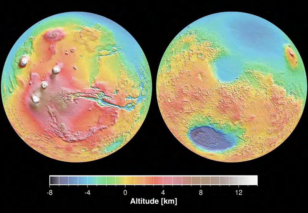
4 Why study geomorphology? Grand challenges in earth surface processes USA National Research Council, 2010 Landscapes on the Edge: New Horizons for Research on Earth's Surface

5 Landscapes are the interface for lithosphere-atmosphere interactions
6
7

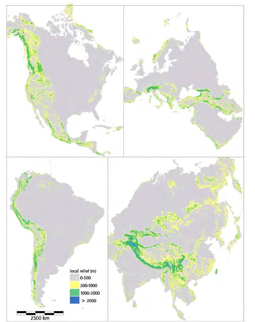
8 Molnar, 2004
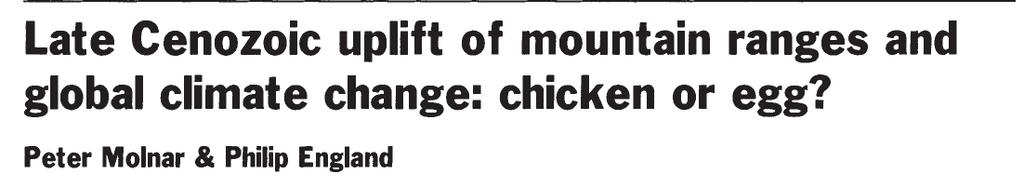
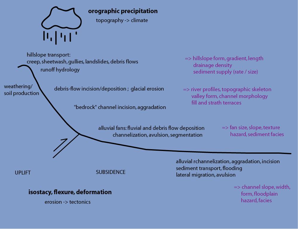
9 Interacting processes
 Event Size, Frequency and Duration (storms, floods, climate variations,")
10 Guiding principles Conservation (of mass, energy, momentum) Transport Rules (flow of water and ice, transport of sediment, etc) Event Size, Frequency and Duration (storms, floods, climate variations, etc)

.")
11 An exiting era for GeomorphologyNew frontiers 1. New geochronologic methods 2. Highly improved computational efficiency 3. Wide spread availability of high resolutions datasets including satellite imagery and Digital Elevation Models (DEM s). The ability to measure and quantify geomorphic features on all scales. 4. Data on extra-terrestrial landscapes

12 LIDAR (Light Detection and Ranging)
13 An exiting era for GeomorphologyNew frontiers 1. New geochronologic methods 2. Highly improved computational efficiency 3. Wide spread availability of high resolutions datasets including satellite imagery and Digital Elevation Models (DEM s). The ability to measure and quantify geomorphic features on all scales. 4. Data on extra-terrestrial landscapes
14


15 1 reconstruct Earth s past in increasing detail including aspects of its geochemistry, biotic processes, topography, and particle and solute fluxes.
16 2
17 2
18 2

19 2 Perron et al., 2009, Nature

20 3 Hasbergen and Paola, Geology
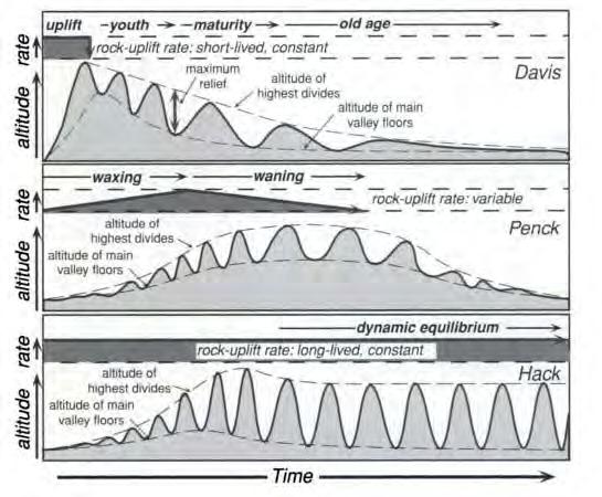
21 Hasbergen and Paola, Geology

22 Lave and Avouac, 2001, JGR

23 Are long-term exhumation rates correlated with monsoon precipitation? Bookhagen and Burbank, 2006
24


25 Egholm et al., 2009, Nature


26 Topography Key questions Horizontal strain Steady state topographic profiles Steady state erosion rate x8 rainfall Stolar, Roe and Willett, 2007 (JGR) Rainfall intensity 3. Are long-term exhumation rates correlated with monsoon precipitation? Hodges, 2006

27 Whipple (2009), Nature modified from Willett (1999), JGR


28 Tree throw Gophers burrowing Gabet et al., 2003
")
29 Roering (2008)


30 Early concepts and prominent figures Grove Karl Gilbert ( , USGS director): The geology of the Henry mountains. Equality of action and dynamic equilibrium, graded rivers Lake Bonneville, discovered crustal flexure due to isostatic rebound and calculated mantle viscosity The convexity of Hilltops 1914 The transportation of debris by running water. Created a flume, modeled transport. Balanced force and resistance. Gilbert, 1909
 uplift.")
31 Early concepts and prominent figures William Morris Davis ( , Harvard Professor): 1899 The geographical cycle The erosion cycle: Mountains evolve to peneplains. Structure, Process and Time dictate landscape evolution. Historical approach. Used evolution to explain natural cycles of landscapes. Assumed rapid (instantaneous) uplift. Davis, 1899
32
")
 1953 - (English")
33 Early concepts and prominent figures Walther Penck ( , Austrian) Morphological Analysis of Landforms (in German) (English version)
34
35
36
Down-stream process transition (f (q s ) = 1)
 = 1)") Down-stream process transition (f (q s ) = 1) Detachment Limited S d >> S t Transport Limited Channel Gradient (m/m) 10-1 Stochastic Variation { Detachment Limited Equilibrium Slope S d = k sd A -θ d S
Down-stream process transition (f (q s ) = 1) Detachment Limited S d >> S t Transport Limited Channel Gradient (m/m) 10-1 Stochastic Variation { Detachment Limited Equilibrium Slope S d = k sd A -θ d S
Intro to Geomorphology Key Concepts
 Intro to Geomorphology Key Concepts Geomorphology Literally means the study of earth landforms - Geo = Earth - Morph=Form - Logos= Study of Involves understanding of - Mineralogy - Structure - Tectonics
Environmental Science EES B02H3 PRINCIPLES OF GEOMORPHOLOGY
 THE UNIVERSITY of TORONTO at SCARBOROUGH January, 2009 Department of Physical & Environmental Sciences Environmental Science EES B02H3 PRINCIPLES OF GEOMORPHOLOGY The earth s surface form and its dynamic
Topographic metrics and bedrock channels Outline of this lecture
 Topographic metrics and bedrock channels Outline of this lecture Topographic metrics Fluvial scaling and slope-area relationships Channel steepness sensitivity to rock uplift Advancing understanding of
THE UNIVERSITY of TORONTO at SCARBOROUGH January, 2010 Department of Physical & Environmental Sciences
 THE UNIVERSITY of TORONTO at SCARBOROUGH January, 2010 Department of Physical & Environmental Sciences Environmental Science EES B02H3 PRINCIPLES OF GEOMORPHOLOGY The earth s surface form and its dynamic
Breakout Session III Evolving landscapes and global environmental change
 Breakout Session III Evolving landscapes and global environmental change 1. Hydrology and critical zone imaging 2. Glaciology: Instrumenting glaciers and ice sheets 3. Polar networks and glacial isostatic
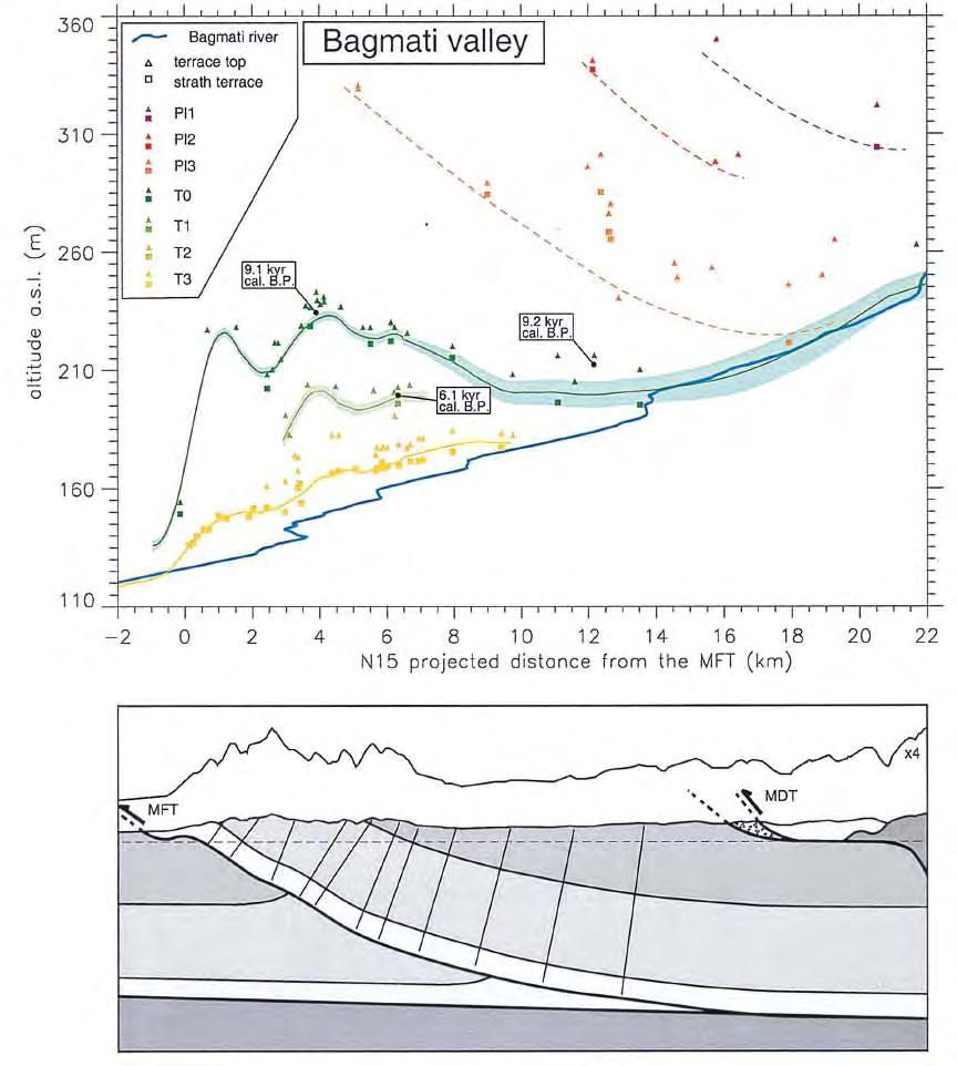
Determination of uplift rates of fluvial terraces across the Siwaliks Hills, Himalayas of central Nepal
 Determination of uplift rates of fluvial terraces across the Siwaliks Hills, Himalayas of central Nepal Martina Böhme Institute of Geology, University of Mining and Technology, Freiberg, Germany Abstract.
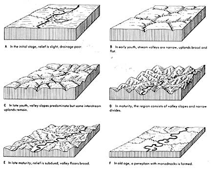
Landscape Development
 CHAPTER 22 Landscape Development Chapter Summary Landscapes are described in terms of their topography: elevation, the altitude of the surface of the Earth above sea level; relief, the difference between
GEOL151 Fall 2016: Lab for Week #7 Drainage Basins: Following a River from Source to Sink
 GEOL151 Fall 2016: Lab for Week #7 Drainage Basins: Following a River from Source to Sink Overview As we enter the middle of the course, we move into more synthetic topics and strive to gain an understanding
ENVIRONMENTAL GEOSCIENCE UNIFORM SYLLABUS
 ENVIRONMENTAL GEOSCIENCE UNIFORM SYLLABUS The Association of Professional Engineers and Geoscientists of the Province of British Columbia Note: 1. This Syllabus May Be Subject To Change 2. These Courses
Drainage Basin Geomorphology. Nick Odoni s Slope Profile Model
 Drainage Basin Geomorphology Nick Odoni s Slope Profile Model Odoni s Slope Profile Model This model is based on solving the mass balance (sediment budget) equation for a hillslope profile This is achieved
Geomorphology LAB FAULT-SCARP DEGRADATION
 Geomorphology LAB FAULT-SCARP DEGRADATION Nicholas Pinter (University of California, Davis) Supplies Needed calculator straight-edge ruler PURPOSE The evolution of the Earth s surface over time is governed
ENVIRONMENT AND NATURAL RESOURCES 3700 Introduction to Spatial Information for Environment and Natural Resources. (2 Credit Hours) Semester Syllabus
 Semester Syllabus") ENVIRONMENT AND NATURAL RESOURCES 3700 Introduction to Spatial Information for Environment and Natural Resources COURSE INSTRUCTOR: Dr. Kris Jaeger Assistant Professor 359 Kottman Hall (Mondays and Tuesdays)
ENVIRONMENT AND NATURAL RESOURCES 3700 Introduction to Spatial Information for Environment and Natural Resources COURSE INSTRUCTOR: Dr. Kris Jaeger Assistant Professor 359 Kottman Hall (Mondays and Tuesdays)
Effects of transient topography and drainage basin evolution on detrital thermochronometer data
 UNIVERSITY OF MICHIGAN Effects of transient topography and drainage basin evolution on detrital thermochronometer data Contents Acknowledgments...3 Abstract...4 1. Introduction...5 2. Model setup...6 2.1
Edinburgh Research Explorer
 Edinburgh Research Explorer GEOMORPHOLOGY Rivers split as mountains grow Citation for published version: Attal, M 2009, 'GEOMORPHOLOGY Rivers split as mountains grow' Nature Geoscience, vol. 2, no. 11,
1 Project Summary. 2 Background
 Student: Lindsay Olinde Course: CE 394K..3 GIS in Water Resources UT Austin Professor: Dr. David Maidment Submitted: December 3, 2010 Investigation into whether differences in channel slope characteristicss
GSA DATA REPOSITORY Sternai et al. 1. Algorithm Flow Chart
 GSA DATA REPOSITORY 2012311 Sternai et al. 1. Algorithm Flow Chart Figure DR1: Flow chart of the algorithm to further clarify the calculation scheme. 2. Reconstruction of the Pre-Glacial Alpine Topography
PHYSICAL GEOLOGY Geology 110 Spring Semester, 2018 Syllabus
 James Madison University Dept of Geology & Environmental Science PHYSICAL GEOLOGY Geology 110 Spring Semester, 2018 Syllabus Instructor: Dr. L. Scott Eaton Office: Memorial Hall 7305E E-mail: eatonls@jmu.edu
GEOL151 Fall 2016: Lab for Week #9 Glacial Erosion, Sediment Transport, and Deposition in the Champlain Valley
 GEOL151 Fall 2016: Lab for Week #9 Glacial Erosion, Sediment Transport, and Deposition in the Champlain Valley Overview This week, we will delve into glacial processes and landforms. Glaciers are generally
The syllabus was approved by Study programmes board, Faculty of Science on to be valid from , autumn semester 2016.
 Faculty of Science GEON05, Quaternary Geology: Glacial Sedimentology - Processes, Sediments and Landform Systems, 15 credits Kvartärgeologi: Glacial sedimentologi - processer, sediment och landformssystem,
topography half is commonly represented in maps, and how it interacts with
 Topography T. Perron 12.001 We ll spend a large fraction of the second half of the course discussing Earth s surface. Today we ll do two things: First, we ll discuss the ways topography is commonly represented
Mountain Environments
 Freshman Seminar Mountain Environments Geography 050, Section 001 Spring 2008 Stephen J. Walsh, Professor Department of Geography Mondays: 3:00-5:30 pm; Murphy Hall Room 202 (919) 962-3867 (voice), (919)
GEOLOGY (GEOL) Geology (GEOL) 1. GEOL 118 Societal Issues in Earth Science (4 crs)
 Geology (GEOL) 1. GEOL 118 Societal Issues in Earth Science (4 crs)") Geology (GEOL) 1 GEOLOGY (GEOL) GEOL 102 Oceanography (3 crs) Survey of the world oceans with emphasis on geologic processes. Also includes chemical, physical, and biological aspects of the sea. Investigates
Geology (GEOL) 1 GEOLOGY (GEOL) GEOL 102 Oceanography (3 crs) Survey of the world oceans with emphasis on geologic processes. Also includes chemical, physical, and biological aspects of the sea. Investigates
mountain rivers fixed channel boundaries (bedrock banks and bed) high transport capacity low storage input output
 high transport capacity low storage input output") mountain rivers fixed channel boundaries (bedrock banks and bed) high transport capacity low storage input output strong interaction between streams & hillslopes Sediment Budgets for Mountain Rivers Little
mountain rivers fixed channel boundaries (bedrock banks and bed) high transport capacity low storage input output strong interaction between streams & hillslopes Sediment Budgets for Mountain Rivers Little
Sensitivity of channel profiles to precipitation properties in mountain ranges
 JOURNAL OF GEOPHYSICAL RESEARCH, VOL. 111,, doi:10.1029/2004jf000164, 2006 Sensitivity of channel profiles to precipitation properties in mountain ranges Shiliang Wu, 1 Rafael L. Bras, 2 and Ana P. Barros
Section 11.1 pp Where Mountains Form
 Section 11.1 pp. 236 237 Where Mountains Form Chapter 11 Set a Purpose: TE, p. 236 Reading Study Guide, p. 36 Discussion: TE, p. 236 Differentiating ion Reading Support: TE, p. 236 Visual Teaching Interpret
Supplementary material
 GSA DATA REPOSITORY2014088 Supplementary material Dominance of tectonics over climate in Himalayan denudation Vincent Godard, Didier L. Bourlès, Françoise Spinabella, Douglas W. Burbank, Bodo Bookhagen,
School Program Name: Name of Sanctuary: Grade Level: Grades 6 8 Location Options: Time:
 School Program Name: Name of Sanctuary: Grade Level: Grades 6 8 Location Options: Time: For more info: Landforms of New England Moose Hill Wildlife Sanctuary At the sanctuary 2 hours or combine with another
ESCI 110: 2 s.h. Introduction to Earth Sciences Programs ESCI 322: 3 s.h. Environmental Hydrology ESCI 241: 4 s.h. Meteorology (G2, L)
") ESCI 110: 2 s.h. Introduction to Earth Sciences Programs General introduction to each of the earth sciences disciplines and to college life. 2 hrs. lec. Offered in fall. Restricted to earth sciences majors.
ESCI 110: 2 s.h. Introduction to Earth Sciences Programs General introduction to each of the earth sciences disciplines and to college life. 2 hrs. lec. Offered in fall. Restricted to earth sciences majors.
Geography 3334a - Geomorphology of River Channels
 THE UNIVERSITY OF WESTERN ONTARIO DEPARTMENT OF GEOGRAPHY Fall 2009 Geography 3334a - Geomorphology of River Channels Class Times Lecture: Tues. 8:30 a.m.- 10:30 a.m. SSC 3102 Lab: Thurs 8:30 a.m.- 10:30
OBJECTIVES. Fluvial Geomorphology? STREAM CLASSIFICATION & RIVER ASSESSMENT
 STREAM CLASSIFICATION & RIVER ASSESSMENT Greg Babbit Graduate Research Assistant Dept. Forestry, Wildlife & Fisheries Seneca Creek, Monongahela National Forest, West Virginia OBJECTIVES Introduce basic
Week 3 (Feb 12): Erosion and Sediment Transport Discussion Leader: Ariel Deutsch
: Erosion and Sediment Transport Discussion Leader: Ariel Deutsch") Week 3 (Feb 12): Erosion and Sediment Transport Discussion Leader: Ariel Deutsch The papers this week explore the topics of erosion and sediment transport, with a major theme revolving around climate-tectonic
Week 3 (Feb 12): Erosion and Sediment Transport Discussion Leader: Ariel Deutsch The papers this week explore the topics of erosion and sediment transport, with a major theme revolving around climate-tectonic
Dougherty County School System 6 th Grade Earth Science Curriculum Matrix
 First Nine Weeks S6E5. Students will investigate the scientific view of how the earth s surface is formed. Week Number Week 1 Week 2 Week 3 Week 4 Week 5 Week 6 Week 7 Standard(s) Scientific Method, Science
UNRAVELING THE HISTORY OF A LANDSCAPE: Using geomorphology, tephrochronology, and stratigraphy. Photo by: Josh Roering
 UNRAVELING THE HISTORY OF A LANDSCAPE: Using geomorphology, tephrochronology, and stratigraphy Photo by: Josh Roering Photo: Eric Bilderback Photo by: Josh Roering Goal 1. Reconstruct the paleo-landscape
Laboratory Exercise #3 The Hydrologic Cycle and Running Water Processes
 Laboratory Exercise #3 The Hydrologic Cycle and Running Water Processes page - 1 Section A - The Hydrologic Cycle Figure 1 illustrates the hydrologic cycle which quantifies how water is cycled throughout
Goals of Today s Lecture. Types of landscapes
 Goals of Today s Lecture 1. Breifly discuss mass continuity as applied to the landscape. 2. Establish the mechanisms that drive U (uplift rate) 3. Examine the linkages between the uplift of mountains,
Course Description. Course Objectives and Standards
 Earth and Space Science Curriculum Course Description Earth and Space Science 1 State # 3044 Grades offered: 10-12 Credits: A two credit course Prerequisite: none Counts as a Science Course for the General,
Fresh Water: Streams, Lakes Groundwater & Wetlands
 Fresh Water:, Lakes Groundwater & Wetlands Oct 27 Glaciers and Ice Ages Chp 13 Nov 3 Deserts and Wind and EXAM #3 Slope hydrologic cycle P = precip I = precip intercepted by veg ET = evapotranspiration
Floodplain modeling. Ovidius University of Constanta (P4) Romania & Technological Educational Institute of Serres, Greece
 Romania & Technological Educational Institute of Serres, Greece") Floodplain modeling Ovidius University of Constanta (P4) Romania & Technological Educational Institute of Serres, Greece Scientific Staff: Dr Carmen Maftei, Professor, Civil Engineering Dept. Dr Konstantinos
Floodplain modeling Ovidius University of Constanta (P4) Romania & Technological Educational Institute of Serres, Greece Scientific Staff: Dr Carmen Maftei, Professor, Civil Engineering Dept. Dr Konstantinos
Earth Science. Explain how Earth's biogeochemical cycles create a balance of materials. Examine the importance of biogeochemical cycles.
 Unit 1: DYNAMIC STRUCTURE OF EARTH Introduction to Understand that earth science is based upon the four sciences of astronomy, geology, meteorology, and oceanography. Identify topics studied within the
GIS and Forest Engineering Applications FE 257 Lecture and laboratory, 3 credits
 GIS and Forest Engineering Applications FE 257 Lecture and laboratory, 3 credits Instructor: Michael Wing Associate Professor Forest Engineering, Resources, and Management Oregon State University Crop
SYLLABUS. 1. Course description. Environmental Sciences. Physical, Chemical and Natural Systems Year: ECTS credits: 4.5.
 1. Course description Degree: Environmental Sciences Course: Natural Hazards Department: Physical, Chemical and Natural Systems Year: 2017-18 Term: Fall ECTS credits: 4.5 Course: 3 rd year Type: Basic
Using Earthscope and B4 LiDAR data to analyze Southern California s active faults
 Using Earthscope and B4 LiDAR data to analyze Southern California s active faults Exercise 8: Simple landscape morphometry and stream network delineation Introduction This exercise covers sample activities
GLG101: What-To-Know List
 Exam 3, Page 1 GLG101: What-To-Know List (Derived from Before You Leave This Page Lists) This list is intended to guide your reading and to help you prepare for the online multiple-choice quizzes. Each
FOREST RESEARCH INSTITUTE, DEHRADUN
 PROJECT REPORT DRAINAGE AND REPLENISHMENT STUDY OF MINED AREA OF GANGA SHYAMPUR RIVER HARIDWAR Submitted to UTTARAKHAND FOREST DEVELOPMENT CORPORATION (UFDC) 73, Nehru Road, Deharadun Prepared&Submitted
correlated to the California Science Content Standards Grade 6
 correlated to the California Science Content s Grade 6 Publisher: McDougal Littell Program Title: McDougal Littell California Middle School Science Series Print Components Pupil Edition, Teacher s Edition,
Sensitivity of orographic precipitation to evolving topography
 1 2 3 4 5 6 Sensitivity of orographic precipitation to evolving topography Joseph Galewsky Department of Earth and Planetary Sciences University of New Mexico Albuquerque, NM, 87131 galewsky@unm.edu 7
A Temporal Hydrologic Database for Rapidly Changing Landscapes
 A Temporal Hydrologic Database for Rapidly Changing Landscapes Using Mt. St. Helens in Washington as a Pilot Site Adam Mosbrucker Geog 575 BACKGROUND: Client / User U.S. Geological Survey Cascades Volcano
GIS feature extraction tools in diverse landscapes
 CE 394K.3 GIS in Water Resources GIS feature extraction tools in diverse landscapes Final Project Anna G. Kladzyk M.S. Candidate, Expected 2015 Department of Environmental and Water Resources Engineering
Application of GIS Technology in Reach- Scale Channel Migration Zone Mapping: Yellowstone River, Montana
 Application of GIS Technology in Reach- Scale Channel Migration Zone Mapping: Yellowstone River, Montana Karin Boyd Applied Geomorphology, Inc. Bozeman, MT Tony Thatcher DTM Consulting, Inc Bozeman, MT
GEOLOGY 10 De Anza College
 GEOLOGY 10 De Anza College Marek Cichanski Office: S-1a Sections 01,02,03 Office hours: M thru Th :30-10:20am; other times by appt. Office phone: (40) 4-4 CLASS WEBSITE: TEXTBOOKS & MATERIALS Lectures:
Did Fluvial Landforms Form Under A Warmer Early Mars?
 Did Fluvial Landforms Form Under A Warmer Early Mars? N. Mangold, LPG Nantes/CNRS, France Acknowledgments: I warmly thank all colleagues and students having worked with me in the last 15 years. Textbook
CAUSES FOR CHANGE IN STREAM-CHANNEL MORPHOLOGY
 CAUSES FOR CHANGE IN STREAM-CHANNEL MORPHOLOGY Chad A. Whaley, Department of Earth Sciences, University of South Alabama, MobileAL, 36688. E-MAIL: caw408@jaguar1.usouthal.edu The ultimate goal of this
GLG362/GLG598 Geomorphology K. Whipple October, 2009 I. Characteristics of Alluvial Channels
 I. Characteristics of Alluvial Channels Self-formed morphology set by entrainment, transport, and deposition They move unconsolidated sedimentary materials present in the valley fill flood plain/bank flow
Watershed concepts for community environmental planning
 Purpose and Objectives Watershed concepts for community environmental planning Dale Bruns, Wilkes University USDA Rural GIS Consortium May 2007 Provide background on basic concepts in watershed, stream,
B13 SSS2.5/GM6.10/HS8.3.7/SSP3.1.20
 SSP Stratigraphy, Sedimentology & Palaeontology Orals Monday, 28 April MO1, 08:30 10:00 MO2, 10:30 12:00 MO3, 13:30 15:00 MO4, 15:30 17:00 TU1, 08:30 10:00 TU2, 10:30 12:00 GM1.7, Non-continuous palaeoenvironmental
GLY 4734/6932: Coastal Morphology and Processes
 GLY 4734/6932: Coastal Morphology and Processes Narrow, but (perhaps the most) dynamic environment on Earth Influenced by both terrestrial and oceanic processes Course is organized into two parts: (1)
Prentice Hall: Science Explorer, 16 Book Series 2005 Correlated to: Alabama Science Standards for Earth and Space Science Core (Grade 6)
") Alabama Science Standards for Earth and Space Science Core (Grade 6) 1. Identify global patterns of atmospheric movement, including El Niño, the Gulf Stream, the jet stream, the Coriolis effect, and global
Alabama Science Standards for Earth and Space Science Core (Grade 6) 1. Identify global patterns of atmospheric movement, including El Niño, the Gulf Stream, the jet stream, the Coriolis effect, and global
Pat Dryer Half Moon Lake: A True Oxbow Lake? Geography 364 April 1 st, 2007
 Pat Dryer Half Moon Lake: A True Oxbow Lake? Geography 364 April 1 st, 2007 Appendix Abstract 2 Introduction 3 Methods 3 Results 3 Discussion 5 Conclusion 11 1 Abstract Half Moon Lake appears to be an
DEPARTMENT OF GEOGRAPHY University of Toronto COURSE OUTLINE
 Detailed Course Outline GGR201S 2015-2016 COURSE: GGR 201S - Geomorphology INSTRUCTOR: DEPARTMENT OF GEOGRAPHY University of Toronto COURSE OUTLINE 2015-2016 Roger Phillips Office: Earth Sciences 2124
SYLLABUS, GEO 432/532 APPLIED GEOMORPHOLOGY
 SYLLABUS, GEO 432/532 APPLIED GEOMORPHOLOGY Spring 2013 College of Earth, Ocean, and Atmospheric Sciences Oregon State University 3 credits T Th 8:00 9:20 am, Wlkn 210 Stephen Lancaster Wlkn 142, 7-9258,
GEOLOGY CURRICULUM. Unit 1: Introduction to Geology
 Chariho Regional School District - Science Curriculum September, 2016 GEOLOGY CURRICULUM Unit 1: Introduction to Geology OVERVIEW Summary In this unit students will be introduced to the field of geology.
ENVS S102 Earth and Environment (Cross-listed as GEOG 102) ENVS S110 Introduction to ArcGIS (Cross-listed as GEOG 110)
 ENVS S110 Introduction to ArcGIS (Cross-listed as GEOG 110)") ENVS S102 Earth and Environment (Cross-listed as GEOG 102) 1. Describe the fundamental workings of the atmospheric, hydrospheric, lithospheric, and oceanic systems of Earth 2. Explain the interactions
ENVS S102 Earth and Environment (Cross-listed as GEOG 102) 1. Describe the fundamental workings of the atmospheric, hydrospheric, lithospheric, and oceanic systems of Earth 2. Explain the interactions
GD3.3/GM3.3/GMPV16/TS4.7
 GM Geomorphology Orals and PICOs MO1, 08:30 10:00 MO2, 10:30 12:00 MO3, 13:30 15:00 MO4, 15:30 17:00 MO5, 17:30 19:00 TU1, 08:30 10:00 TU2, 10:30 12:00 TUL, 12:15 13:15 TU3, 13:30 15:00 Monday, 08 April
Map Mysteries Activities
 Page 1 of 8 Map Mysteries Activities 74,796 Ready-To-Go Lesson Plans Teaching Earth Science and Geography with USGS Topographic and Thematic Maps Author: Dr. Joseph J. Kerski Geographer Box 25046 - MS
Elevations are in meters above mean sea level. Scale 1:2000
 12.001 LAB 7: TOPOGRAPHIC MAPS Due: Monday, April 11 PART I: CONTOURING AND PROFILES (20 PTS) 1. Contour this area map using a 5 meter contour interval. Remember some fundamental rules of contour lines,
Examining the Terrestrial Planets (Chapter 20)
") GEOLOGY 306 Laboratory Instructor: TERRY J. BOROUGHS NAME: Examining the Terrestrial Planets (Chapter 20) For this assignment you will require: a calculator, colored pencils, a metric ruler, and your geology
GEOLOGY 306 Laboratory Instructor: TERRY J. BOROUGHS NAME: Examining the Terrestrial Planets (Chapter 20) For this assignment you will require: a calculator, colored pencils, a metric ruler, and your geology
Neogene Uplift of The Barents Sea
 Neogene Uplift of The Barents Sea W. Fjeldskaar A. Amantov Tectonor/UiS, Stavanger, Norway FORCE seminar April 4, 2013 The project (2010-2012) Funding companies Flat Objective The objective of the work
Slide #2. What is the drainage pattern that you can see on this hillslope? What hillslope hydrologic phenomenon is well exemplified on this hillslope?
 Geology 22 Process Geomorphology Final Exam Fall, 1999 Name This exam is closed book and closed notes. Take some time to read the questions carefully before you begin writing. Answer the questions concisely
Weathering, Erosion, Deposition, and Landscape Development
 Weathering, Erosion, Deposition, and Landscape Development I. Weathering - the breakdown of rocks into smaller particles, also called sediments, by natural processes. Weathering is further divided into
Sediment production in Tuni lake catchment due to climate change
 Sediment production in Tuni lake catchment due to climate change (Proyecto Grande/Erosión y Sedimentación) Ramiro Pillco Zolá &, Seiki Kawagoe, Vanesa Vera San Andres Major University, Bolivia Fukushima
GEOGRAPHY OF LANDFORMS COURSE DESCRIPTION GEOG 574. Fall Maingi Solomon
 GEOG 574 GEOGRAPHY OF LANDFORMS Fall 2015 Maingi Solomon COURSE DESCRIPTION This course will explore the geography of earth s major landforms and the geographical factors that influence their development,
Table 6.1 Progress in the identification of equilibrium states in geomorphology
 6 The concept of equilibrium emerged in geomorphology once ideas of catastrophism had been succeeded by the understanding that gradual land-forming processes were responsible for the shape of the Earth
GEOLOGY 10 De Anza College
 GEOLOGY 0 De Anza College Marek Cichanski Office: S-a CLASS WEBSITE: TEXTBOOKS & MATERIALS Sections 0,0,0 Lectures: M - Th, 0:0-:0am Labs: T, W, Th, :0-:0pm Office hours: M thru Th :0am-:0pm; Friday 9:0am-0:0am
Lab Final Review 4/16/18
 Lab Final Review 4/16/18 Overall goals from lab Think about geology on recent timescales, predict the direction change Be able to identify how different landforms or patterns (e.g. drainage patterns, dune
GEOLOGY 10 De Anza College
 GEOLOGY 0 De Anza College Marek Cichanski Office: S-5a CLASS WEBSITE: TEXTBOOKS & MATERIALS Sections 0,02,0 Lectures: M - Th, 0:0-:20am Labs: T, W, Th, :0-4:20pm Office hours: M thru Th :0am-2:20pm; other
Susquehanna River Basin A Research Community Hydrologic Observatory. NSF-Funded Infrastructure Proposal in Support of River Basin Hydrologic Sciences
 Susquehanna River Basin A Research Community Hydrologic Observatory NSF-Funded Infrastructure Proposal in Support of River Basin Hydrologic Sciences Fundamental Problem: How Do Humans and Climate Impact
Critical form and feedbacks in mountain-belt dynamics: the role of. rheology as a tectonic governor.
 Critical form and feedbacks in mountain-belt dynamics: the role of rheology as a tectonic governor. Gerard H. Roe Department of Earth and Space Sciences, University of Washington, Seattle, WA. Mark T.
Natural hazards in Glenorchy Summary Report May 2010
 Natural hazards in Glenorchy Summary Report May 2010 Contents Glenorchy s hazardscape Environment setting Flood hazard Earthquakes and seismic hazards Hazards Mass movement Summary Glossary Introduction
Hydrologic Engineering Applications of Geographic Information Systems
 Hydrologic Engineering Applications of Geographic Information Systems Davis, California Objectives: The participant will acquire practical knowledge and skills in the application of GIS technologies for
Hydrologic Modelling of the Upper Malaprabha Catchment using ArcView SWAT
 Hydrologic Modelling of the Upper Malaprabha Catchment using ArcView SWAT Technical briefs are short summaries of the models used in the project aimed at nontechnical readers. The aim of the PES India
SLOPE DISTRIBUTIONS, THRESHOLD HILLSLOPES, AND STEADY-STATE TOPOGRAPHY
 [American Journal of Science, Vol. 301, April/May, 2001, P.432 454] SLOPE DISTRIBUTIONS, THRESHOLD HILLSLOPES, AND STEADY-STATE TOPOGRAPHY DAVID R. MONTGOMERY Department of Geological Sciences, University
Graduate Courses Meteorology / Atmospheric Science UNC Charlotte
 Graduate Courses Meteorology / Atmospheric Science UNC Charlotte In order to inform prospective M.S. Earth Science students as to what graduate-level courses are offered across the broad disciplines of
FUTURE MEANDER BEND MIGRATION AND FLOODPLAIN DEVELOPMENT PATTERNS NEAR RIVER MILES 241 TO 235, SACRAMENTO RIVER
 FUTURE MEANDER BEND MIGRATION AND FLOODPLAIN DEVELOPMENT PATTERNS NEAR RIVER MILES 241 TO 235, SACRAMENTO RIVER Eric W. Larsen University of California, Davis With the assistance of Evan Girvetz REPORT
Surface Processes Focus on Mass Wasting (Chapter 10)
") Surface Processes Focus on Mass Wasting (Chapter 10) 1. What is the distinction between weathering, mass wasting, and erosion? 2. What is the controlling force in mass wasting? What force provides resistance?
Surface Processes Focus on Mass Wasting (Chapter 10) 1. What is the distinction between weathering, mass wasting, and erosion? 2. What is the controlling force in mass wasting? What force provides resistance?
The Effects of Hydraulic Structures on Streams Prone to Bank Erosion in an Intense Flood Event: A Case Study from Eastern Hokkaido
 Symposium Proceedings of the INTERPRAENENT 2018 in the Pacific Rim The Effects of Hydraulic Structures on Streams Prone to Bank Erosion in an Intense Flood Event: A Case Study from Eastern Hokkaido Daisuke
Earth Science. Lessons: 15% Quizzes: 25% Projects: 30% Tests: 30% Assignment Weighting per Unit Without Projects. Lessons: 21% Quizzes: 36% Tests: 43%
 Earth Science Earth Science explores Earth s structure, interacting systems, and place in the universe. The course covers concepts and processes found in: Astronomy Earth s place in and interaction with
Bedrock channel geometry along an orographic rainfall gradient in the upper Marsyandi River valley in central Nepal
 San Jose State University From the SelectedWorks of Emmanuel J. Gabet July 25, 2007 Bedrock channel geometry along an orographic rainfall gradient in the upper Marsyandi River valley in central Nepal William
GEOLOGY 100 Planet Earth Spring Semester, 2007
 GEOLOGY 100 Planet Earth Spring Semester, 2007 Instructor: Michael A. Stewart, 250 Natural History Building Phone: 244-5025 Email: stewart1@uiuc.edu Office hours: Friday 1:00-2:30 pm by appointment Discussion
Sediments and bedrock erosion
 Eroding landscapes: fluvial processes Sediments and bedrock erosion Mikaël ATTAL Marsyandi valley, Himalayas, Nepal Acknowledgements: Jérôme Lavé, Peter van der Beek and other scientists from LGCA (Grenoble)
GLY 4734/6932: Coastal Morphology and Processes
 GLY 4734/6932: Coastal Morphology and Processes In-Class Exercise think about these questions to answer at the end of class Name and where are you from? What coast are you most familiar with or are you
Glaciology (as opposed to Glacial Geology) Why important? What are glaciers? How do they work?
 Why important? What are glaciers? How do they work?") Glaciology (as opposed to Glacial Geology) Why important? What are glaciers? How do they work? Glaciers are important because of their role in creating glacial landscapes (erosional and depositional features).
Glaciology (as opposed to Glacial Geology) Why important? What are glaciers? How do they work? Glaciers are important because of their role in creating glacial landscapes (erosional and depositional features).
Talk Overview. Concepts. Climatology. Monitoring. Applications
 Atmospheric Rivers Talk Overview Concepts Climatology Monitoring Applications Satellite View Where is the storm? Where is the impact? Atmospheric Rivers Plume or fire hose of tropical moisture Heavy precipitation
GEOL 23100: Principles of Geomorphology
 GEOL 23100: Principles of Geomorphology 1 Geomorphology The word geomorphology" comes from the Greek roots "geo, morph, and logos, meaning earth, form, and study, respectively. Therefore, geomorphology
Rivers T. Perron
 1 Rivers T. Perron 12.001 After our discussions of large-scale topography, how we represent topography in maps, and how topography interacts with geologic structures, you should be frothing at the mouth
David Tenenbaum GEOG 070 UNC-CH Spring 2005
 GEOG 070 Introduction to Geographic Information GEOG 070 Introduction to Geographic Information Course Description: There is a spatial component to all that occurs on our planet. Everything happens somewhere
High resolution spatiotemporal distribution of rainfall seasonality and extreme events based on a 12-year TRMM time series
 1 2 3 4 High resolution spatiotemporal distribution of rainfall seasonality and extreme events based on a 12-year TRMM time series Bodo Bookhagen, Geography Department, UC Santa Barbara, Santa Barbara,
Surface changes caused by erosion and sedimentation were treated by solving: (2)
") GSA DATA REPOSITORY 214279 GUY SIMPSON Model with dynamic faulting and surface processes The model used for the simulations reported in Figures 1-3 of the main text is based on two dimensional (plane strain)
GSA DATA REPOSITORY 214279 GUY SIMPSON Model with dynamic faulting and surface processes The model used for the simulations reported in Figures 1-3 of the main text is based on two dimensional (plane strain)
CAPE Unit 1 Module 2 & 3. Topic Specific Objectives Content Explain the main concepts, flows and processes associated with coastal environments
 # Week(s) Wks 1-3 CAPE Unit 1 Module 2 & 3 Topic Specific Objectives Content Explain the main concepts, flows and processes associated with coastal environments Wave formation, structure, types Textbook
Watershed Sciences 4930 & 6920 GEOGRAPHIC INFORMATION SYSTEMS
 PURPOSE OF TODAY S LECTURE: Watershed Sciences 4930 & 6920 GEOGRAPHIC INFORMATION SYSTEMS WEEK ONE Lecture 1 Introduction to Course & Review of Maps Joe Wheaton Introduction to Course & Review of Maps