Catalogue of active geothermal manifestations in West Iceland
|
|
|
- Lucinda Stevens
- 5 years ago
- Views:
Transcription
1 Report Project no.: Catalogue of active geothermal manifestations in West Iceland (1): Kleppjárnsreykir, Kársnes, Deildartunga, Hurðarbak South in Borgarfjörður Maryam Khodayar Héðinn Björnsson Prepared for the Energy Resources Division of Orkustofnun ÍSOR-2005/011 March 2005 ICELAND GEOSURVEY Reykjavík: Orkugarður, Grensásvegi 9, 108 Rvk. Tel.: Fax: Akureyri: Rangárvöllum, P.O. Box 30, 602 Ak. Tel: Fax:
2
3 Key page Report no. Date Distribution ÍSOR-2005/011 March 2005 Open Closed Report name / Main and subheadings Catalogue of active geothermal manifestations in West Iceland (1): Kleppjárnsreykir, Kársnes, Deildartunga, Hurðarbak South in Borgarfjörður Authors Maryam Khodayar and Héðinn Björnsson Number of copies 15 Number of pages 71 Project manager Maryam Khodayar Classification of report Project no. Tectonic geothermal mapping Prepared for The Energy Resources Division of Orkustofnun Co-operators Abstract The results of a campaign of GPS-mapping of geothermal manifestations in the Borgarfjörður of West Iceland are reported. The work is a part of the project Bergsprungur í skjálftabeltum og gosbeltum. Five areas were selected for the mapping. Four are in Reykholtsdalur and is near the shores of Hvítá river. All areas are a short way south of the epicentre of the 1974 Borgarfjörður earthquakes. The field investigations consisted of mapping of the hottest geothermal areas with a GPS device. These areas were identified on the basis of temperature profiles as well as other typical features associated with geothermal manifestations. Qualitative observations were also made simultaneously on each mapped point. The geothermal manifestations mapped are complementary information on the status of tectonics in West Iceland, with respect to the evolution of the plate boundaries and intra-plate deformation. The results show reactivation of the underlying tectonic structures leading to geothermal activity at the surface, as well as a strong relation with the 1974 intra-plate earthquakes in Borgarfjörður. The present catalogue of the raw field data is prepared at the request of the Energy Resource Division of Orkustofnun in order to be incorporated into the databank of Orkustofnun. Fracture analysis in relation to geothermal was also carried out during this campaign, but data will be presented separately. Key words Geothermal manifestations, Reykholtsdalur, GPS-mapping, temperature profiles, tectonics, databank, catalogue ISBN-number Project manager s signature Reviewed by HF - 2 -
4 TABLE OF CONTENTS INTRODUCTION... 5 CHAPTER 1 KLEPPJÁRNSREYKIR SKRÚÐUR... 9 CHAPTER 2 KÁRSNES SOUTH CHAPTER 3 KÁRSNES NORTH CHAPTER 4 DEILDARTUNGA CHAPTER 5 HURÐARBAK SOUTH REFERENCES
5 INTRODUCTION In the autumn of 2004, we carried out a campaign of GPS-mapping of geothermal manifestations in the Borgarfjörður Block in West Iceland. This block is caught between the active Reykjanes-Langjökull Rift Zone to the east and the extinct Tertiary Snæfellsnes Rift Zone to west (Fig. 1). A Quaternary intra-plate volcanic chain, the Snæfellsnes Volcanic Zone, stretches perpendicular to these rift zones. The 1974 Borgarfjörður intra-plate earthquakes, up to magnitude 6 (Einarsson et al., 1977), occurred at the eastern tip of this volcanic zone (Fig. 1). Five areas covering a northerly zone were selected for the GPS-mapping of geothermal manifestations (Khodayar et al., 2004; Björnsson, 2005). From south to north these are Kleppjárnsreykir, Kársnes South, Kársnes North, Deildartunga, and Hurðarbak South (Fig. 2). The first four areas are in Reykholtsdalur, and the last one is near the southern shore of Hvítá River. These manifestations are located near to the epicentre of the 1974 Borgarfjörður earthquakes. The field investigations involved mapping of the hottest geothermal areas with a GPS device. We identified these areas on the basis of temperature measurements as well as typical features associated with geothermal manifestations. Qualitative observations were made on each mapped point. Water chemistry and discharges, were not studied during our investigations, however. Our field investigations are a part of the project Bergsprungur í skálftabeltum og gosbeltum. This project focuses on the geology and tectonics of West and South Iceland with respect to the evolution of the rifts and the transform zone(s). The geothermal manifestations mapped are complementary information that leads to better understanding of the latest status of tectonics in West Iceland. Results of this mapping show a probable reactivation of the underlying tectonics leading to geothermal activity at the surface. At the request of the Energy Resources Division of Orkustofnun, we prepared the present catalogue containing the raw field data collected during our campaign of GPSmapping. This is in order to incorporate the data in a databank. Each of the five mapped areas is presented in one separate chapter within the catalogue. The maps, points (P), temperatures, features, general comments, coordinates, and photographs (when available) are given for each mapped feature. The directions of the structures on the map are given by the GPS-device with respect to the North. Fracture analysis in relation to the geothermal manifestations was also carried out during this campaign, but data are presented separately, in a work in preparation. That - 5 -
6 work will also deal with a more thorough interpretation of the results of the GPS-mapping with respect to the seismicity and the evolution of the plate boundaries and intraplate tectonics in West Iceland. Notes: The size of the geothermal manifestations on the maps is slightly exaggerated for clarity. The coordinates presented in the catalogue are those obtained by the GPS device Trimble, used for the mapping. These coordinates may present distortion if projected onto topographical maps. Due to the resolution of the GPS-technology, the location of the smaller features below 2 m size may present an inaccuracy of 1 2 m. For single point, the coordinates presented are of those of the point, but for areas, the coordinates correspond to the beginning of the structure
7 - 7 -

8 - 8 -
9 Chapter 1 KLEPPJÁRNSREYKIR SKRÚÐUR - 9 -
10 - 10 -
11 - 11 -
12 Locality Point (P) Number Max. temperature inside of the structure (in C ) Other temperature inside of the structure (in C ) Temperature in geothermal zone outside of the structure (in C ) White deposition (silica?) Algae Oxidation and possible silica deposition Bubbles Tectonic alignment of the manifestations Kleppjárnsreykir-Skrúður (N of Björk) Comment GPS coordinates Picture 1 a , 97.1 X X b c 10 cm to the N: 66.5, 60 X X X X d X e 98 f 96.2 X g 99.4 Concrete structure with steam escaping from a pipe in it In the geothermal stream flowing from P1 (a) Another concrete structure on top of manifestation(s) Heavily boiling spring inaccessible for temperature measurement Concrete structure around springs A small boiling spring beneath a concrete construction Boiling spring beneath a concrete structure 64 39'14,77402'' N 21 24'09,25999'' W 64 39'14,85089'' N 21 24'09,38493'' W 64 39'15,02722'' N 21 24'08,92878'' W 64 39'15,04776'' N 21 24'08,95732'' W 64 39'15,44412'' N 21 24'09,02658'' W 64 39'15,26606'' N 21 24'09,06757'' W 64 39'15,43115'' N 21 24'09,30873'' W Figs. 4a and 4b Figs. 4a and 4b Fig. 4a Fig. 4a Fig. 4a Fig. 4a Fig. 4a
13 To the S, on a N-S line: 74, 80, 64.1, 62.5, 63.9 At 1.5 m, 3 m, and 5 m to the N: 54.1, 48.1, 32.6 ; at 5 cm to the W: 50 ; at 5 cm to the E: 54 X X N32 Hottest points on a N32 line in a sub-channel 64 39'21,18261'' N 21 24'16,76945'' W Kleppjárnsreykir-Skrúður (N of Björk) , , 85.2, 84.4 To the N, on a N-S line: 57.5, , 57.4, , 64.8, X X X X X X X N14 3 eyes, the biggest with 15 cm diameter and 10 cm depth. Form a tectonic line N03 with P eyes with irregular shape. Form a tectonic line N03 with P.3 and P eyes, each 4 cm diameter, forming a N14 line. Form a net tectonic line N03 with P.3-4 and P.6-8 Form a tectonic line N03 with P.3-5 and P '21,439003'' N 21 24'16,49338'' W 64 39'21,42896'' N 21 24'16,52155'' W 64 39'21,51973'' N 21 24'16,49937'' W 64 39'21,30245'' N 21 24'16,42072'' W X Form a tectonic line N03 with P.3-6 and P '21,60905'' N 21 24'16,33911'' W X Form a net WNW tectonic line with P.9 and P.22, and N03 with P '21,75834'' N 21 24'16,40057'' W Fig , 44.9 X Form a net WNW tectonic line with P.8 and P '21,83257'' N 21 24'16,71066'' W Fig
14 m to the N: 52.7 X Small eye with irregular shape in sediments. Could form a tectonic line N165 with P.11-13, 17, and '21,52611'' N 21 24'16,87842'' W Fig X Could form a tectonic line N165 with P.10, 12-13, 17, and '21,46434'' N 21 24'16,96730'' W Fig. 5 Kleppsjárnsreykir-Skrúður (N of Björk) X X X At 30 cm: 53,3. 30 cm to N: 50,6 X Eye in sediments. Could form a tectonic line N165 with P.10-11, 13, 17, and Eye. Could form a tectonic line N165 with P.10-12, 17, and eyes with 10 cm diameter. Only the hottest is mapped. Form a tectonic line N10 with P , 45.2 X N65 Manifestations on a N65 line , 65.1, 45.4, 37.1, 42 X N20 Manifestations on a N20 line 64 39'21,49080'' N 21 24'16,96732'' W 64 39'21,46516'' N 21 24'16,92195'' W 64 39'21,52534'' N 21 24'17,41354'' W 64 39'21,39994'' N 21 24'17,11364'' W 64 39'21,48027'' N 21 24'17,20487'' W Fig X Could form a tectonic line N165 with P.2, P.10-13, and '21,59890'' N 21 24'17,09039'' W Fig , 61.2 X 3 eyes; only the hottest is mapped. Could form a tectonic line N10 with P.14, and '21,66389'' N 21 24'17,34412'' W Fig X X Could form a tectonic line N10 with P.14, P.18, and P '21,60397'' N 21 24'17,34922'' W Fig
15 , , 58.2, 62.2, 59.8, 61.7, 50.2, 60.8, 53.9, 57.2, 52.3, 39, 45.9 X N10 Manifestations on a N10 line. Could form a general tectonic line N10 with P.14, P and P '21,63103'' N 21 24'17,31957'' W Fig. 7 Kleppjárnsreykir-Skrúður (N of Björk) On a N-S line to the S: 52.5, 35.4, 43.8 To the W: 48.7 ; at 0.40 m, 1.4 m and 2 m to the N: 45, 44, 35.5 X X X On a NE- SW line, including P.24: 78.2, 60.4, 66.4, 70, 57.8, 64.1, 58.3, 61.2 at 5 m, 10 m, 15 m, 20 m, and 25 m to SW: 53.9, 44.6, 40.4, 40.7, 39.1 X X Eye with 30 cm diameter and 40 cm depth. Could form a tectonic line N165 with P.10-13, 17, and 22, and a tectonic line N10 with P.14, P and P.22 Eye with 10 cm diameter and 10 cm depth. Form a net WNW tectonic line with P.8-9. Could form a tectonic line N165 with P.10-13, 17, and 21, and a tectonic line N10 with P.14, P Big boiling pool with bursting water. Concrete construction around it. Could form tectonic line N45 with P.24 On a N45 line, in the small geothermal stream running from P.23. Form tectonic line N45 with P.23 Outline of the area containing P '21,73736'' N 21 24'17,14841'' W 64 39'21,94073'' N 21 24'17,15463'' W 64 39'21,06263'' N 21 24'17,63268'' W 64 39'21,05669'' N 21 24'17,67489'' W 64 39'20,78933'' N 21 24'18,44180'' W Fig. 7 Fig
16 Kleppjárnsreykir-Skrúður (N of Björk) , , 62.3 Surrounding P. 26: 44.6, 44.9, 51.1 ; S of it, on a N-S line: 36.8, 37.4, 37.4, 38.3, 44.9, 40.9, 37.9, 37.8 At 10 cm: 42.1, 44.5 At 10 and 20 cm to N: 52 and 50 ; To W: 47.9 ; at 10 and 20 cm to the S: 54.5 and cm to N: 55.1 East of the ditch. Form a N-S tectonic line with P East of the ditch. Form a N-S tectonic line with P.26, and P East of the ditch. Form a N-S tectonic line with P.26-27, and P East of the ditch. Form a N-S tectonic line with P and P '25,45921'' N 21 24'18,71654'' W 64 39'25,51695'' N 21 24'18,77161'' W 64 39'25,53211'' N 21 24'18,76142'' W 64 39'25,55637'' N 21 24'18,77645'' W Surrounding: 47.1, 48.2, 42.8 ; at 1 and 2 m to the N: 38.9 and 38.3 East of the ditch. Form a N-S tectonic line with P These points are all south of the pipe that is transversal to the ditch 64 39'25,60907'' N 21 24'18,75208'' W


17 - 17 -


18 - 18 -
19 Chapter 2 KÁRSNES SOUTH
20 - 20 -
21 - 21 -
22 Locality Point (P) Number Max. Temperature inside the structure (in C ) Other Temperature inside the structure (in C ) Temperature in geothermal zone outside the structure (in C ) White deposition (Silica?) Algae Oxidation and possible silica deposition Bubbles Tectonic alignment of the manifestations Comment GPS Coordinates Picture At 20 and 25 cm to the N: 91.1 and 78.9 ; at 30 cm to the NE: 87.7, 25 cm to the E: 71.1, 25 cm to the SE: 92.6, 50 cm to the S: 91.3 X X X X Big eye, with 50 cm diameter, 30 cm depth, in a pool from where runs a geothermal stream 64 39'32,73027'' N 21 24'18,68691'' W Figs. 9a and 9b Kársnes South 32 At 1.5 m S of P. 32, down stream on an E-W line: 87.3, 81.5, 82, 75.7, 73.8, 72.1, 68.6 ; then on a N-S line: 62.9, 61.4, 59 X X X X The pool with 0.60 m diameter containing P '32,67731'' N 21 24'18,60505'' W Figs. 9a and 9b
23 a '28,86991'' N 21 24'14,24513'' W b 14.1 To the W: '28,83836'' N 21 24'14,28881'' W Kársnes South 33 c 11.4 d 14.2 To the E: 4.6 Ground temperature at the time of measurement is < 4 C. Ice exists everywhere in the river, except in the northern shore of Reykjadalsá where P.33 a-k are located. These points are to the northeast of the greenhouse of Skrúður 64 39'28,87332'' N 21 24'14,63915'' W 64 39'28,86629'' N 21 24'14,65801'' W e '28,87215'' N 21 24'14,82168'' W f 11.7 To the W: '28,92062'' N 21 24'14,94823'' W g '28,83448'' N 21 24'15,34509'' W
24 h '28,86576'' N 21 24'15,51878'' W 33 i 14.8 j 11.9 Ground temperature at the time of measurement is < 4 C. Ice exists everywhere in the river, except in the northern shore of Reykjadalsá where P.33 a-k are located. These points are to the northeast of the greenhouse of Skrúður 64 39'28,84806'' N 21 24'15,60113'' W 64 39'28,84290'' N 21 24'15,67361'' W Kársnes South k '28,87440'' N 21 24'15,93474'' W , 63.4 To the W: 42, 34.3 X 22 Isolated water pond 64 39'33,73402'' N 21 24'25,53724'' W cm to the S: 42.4 ; 20 cm to N: 38.6 X Shallow small water pool in sediments 64 39'33,49159'' N 21 24'25,57472'' W cm to the S: cm to the S: 38.6 ; 20 cm to the N: 40.6 X 64 39'33,57143'' N 21 24'25,69894'' W
25 To the N, on a N-S line: 76.9, 62, 59.7, 62.2, 58 In the geothermal stream: 51.1, 46.7, 49, 34 X X X N140 Beautiful perfect big eye, with 1 m diameter, 0.5 m depth in sediment. Form a N140 line with P.35 and P.36. Very little deposition (silica?). Bubbles in the central part 64 39'33,57600'' N 21 24'25,85482' W Fig At 0.5 m to the W, to the S, to the N, and to the E: 40.9, 40.3, 33.4, 40 X X N110 Big beautiful eye 1 m diameter, 20 cm depth, in swampy sediments, with bubbles in the central part, aligned N110. Worms and small fishes swimming near the eye. Very special light green colour 64 39'32,00527'' N 21 24'25,37256' W Fig. 11 Kársnes South Very big eye, with 1 m diameter and at least 2 m depth, in the geothermal stream and swampy sediments 64 39'32,89192'' N 21 24'25,79721'' W Group of small eyes with 2-3 cm diameter, in the sediments inside the stream. Could form a N155 line with P '33,07920'' N 21 24'25,95040' W 41 Outline of the area containing P and P These points are north of Reykjadaslá and the water from this river mixes with geothermal water through a channel 64 39'32,92610'' N 21 24'26,85308' W
26 , 58.5 X Group of small eyes with 3-4 cm diameter in swampy sediments in the geothermal stream. Altered gastropod shells and dead small fishes lie by the eyes 64 39'33,04514'' N 21 24'25,53748'' W Between P. 42 and 43: 48, 40.5, 45.5 Group of small eyes in swampy sediments in the stream. Forms a N150 line with P '33,08262'' N 21 24'25,61689' W Kársnes South Between P. 43 and 44: 35, 34.1, 33.5 Between P. 44 and 45: 33.3, 36.2, 35.7 X X Group of small eyes in sediments of the stream A small eye with 3 cm diameter. Form a N125 line with P '33,25551'' N 21 24'25,89777' W 64 39'33,32138'' N 21 24'25,99480'' W , 57.8, 50.2 Surrounding: 13.2, 9.1, 5.7 At the northern flank of Reykjadalsá river, against yellow grass field. Special green vegetation associated with manifestation 64 39'30,30743'' N 21 24'23,89105' W Between P. 46 and 47: 9.9, 7.1, 7.6 At the northern flank of Reykjadalsá river, against yellow grass field. Special green vegetation associated with manifestation 64 39'30,30391'' N 21 24'24,30204' W
27 Kársnes South On two N-S lines to the S. The western line: 11.7, 18.5, 15.2, 16.2, 15, 17, 15.1, 10. The eastern line: 12, 13, 12.2, 13, 11.3, 10.1, 10, 10.5 To the N: ; to the W: P.48 is in a zone, found by temperature measurements along two parallel N-S lines. The zone is in the grass field, without surface manifestation. Soil temperature was ~ 5 C at the time of mapping 64 39'34,63286'' N 21 24'19,49427' W


28 - 28 -


29 - 29 -
30 - 30 -
31 Chapter 3 KÁRSNES NORTH
32 - 32 -
33 - 33 -
34 Locality Point (P) Number Max. temperature inside of the structure (in C ) Other temperature inside of the structure (in C ) Temperature in geothermal zone outside of the structure (in C ) White deposition (Silica?) Algae Oxidation and possible silica deposition Bubbles Tectonic alignment of the manifestations Comment GPS coordinates Picture At 0.5 m to the S: 42.5, 45.1, 38.8, 47.4 ; at 3 m to the N: 20.8, 20.5, 21.9, 32.2, 38 1 m to the NE: 40.8 ; at 1 m to the S: 29.3 ; at 1 m to the NW: 21.2 ; 1 m to the W: 35.5 X X Eye with 20 cm diameter, in a small pond full of swampy sediments. Many dead worms present Eye with 30 cm diameter, 20 cm depth, in swampy sediments. Could form a N25 line with P '44,08541'' N 21 24'29,08017' W 64 39'44,28668'' N 21 24'28,83899' W Kársnes North X Eye with 20 cm diameter in swampy sediments on the edge of grassy area in the pond. Very little algae 64 39'44,44031'' N 21 24'28,93175'' W
35 X Eye in swampy sediments in a 1.5-m diameter pond. Jellytype alteration (algae and sediments) 64 39'44,53574'' N 21 24'28,87629' W X Eye in swampy sediments in a 1.5-m diameter pond. Jellytype alteration (algae and sediments) 64 39'44,55899'' N 21 24'28,90101' W Kársnes North X X X X Eye in swampy sediments in a 1.5-m diameter pond. Jellytype alteration (algae and sediments) Outline of the area containing P Eye with small discharge in swampy sediments 64 39'44,56883'' N 21 24'28,92610'' W 64 39'44,56367'' N 21 24'28,79992'' W 64 39'44,65271'' N 21 24'28,39198' W Fig X Eye in the N140 man-made channel 64 39'44,58569'' N 21 24'28,38256'' W Fig Small eye in swampy sediments on the grassy edge of the N140 man-made channel 64 39'44,58069'' N 21 24'28,48050' W Fig cm to the W: 53.6 ; 50 cm to the N: 52 Small eye on the edge of a small pond. Form a N10 line with P '44,72658'' N 21 24'28,75683' W Fig
36 At 50 cm to the S, SW, W, N, and E of P. 59: 41.6 ; 42.4 ; 44.8, 48, 53.6 In the middle of the same pond as P.59. Could form a line N14 with P '44,77377'' N 21 24'28,74320'' W Fig. 14 Kársnes North To the S, on a N-S line: 53.3, 54.9, , 54.9, 50.3, 61.4, 63.2, 48, 69.8, 53.6, 52, 65.7, 70.7 On a WNW line E of P. 61, every 5 m: 46.4, 34.7, 27.6, 24.9, 26.8, 22.2, 22.4, 24.3, 21.9 From P.62, every 5 m to the SE: 46.4, 34.7, 27.6, 24.9, 26.8, 22.2, 22.4, 24.3, N of P. 62: 46.9, 42.4, 44.8, 41.6 X N142 In the middle of the channel. Form a line N80 with P.57 and 58 Outline of the area containing P '44,58369'' N 21 24'28,39627' W 64 39'44,54494'' N 21 24'28,30126' W Fig X X Eye with 10 cm diameter, 0.5 m depth, in swampy sediments In swampy sediments. Could form a N120 line with P.65 and a N15 line with P '45,11487'' N 21 24'28,31468'' W 64 39'45,30694'' N 21 24'28,08379'' W
37 In swampy sediments. Could form a N120 line with P '45,21527'' N 21 24'28,34452'' W Kársnes North , 44, 36.5, , 44.6, 42.3, 32.9 X X Pond with 1 m diameter, 20 cm depth, containing P.63 Pond with 1 m diameter, 15 cm depth, containing P '45,14864'' N 21 24'28,30392'' W 64 39'45,20087'' N 21 24'28,36537'' W 68 Outline of the area containing P '45,28870'' N 21 24'28,23724'' W


38 - 38 -
39 Chapter 4 DEILDARTUNGA
40 - 40 -
41 - 41 -
42 Locality Point (P) Number Max. temperature inside of the structure (in C ) Other temperature inside of the structure (in C ) Temperature in geothermal zone outside of the structure (in C ) White deposition (Silica?) Algae Oxidation and possible silica deposition Bubbles Tectonic alignment of the manifestations Comment GPS coordinates Picture To the E, on an E-W line: 86, 82.6, 67.5, 68, 70.3, 65, cm to E: 33.6 ; 10 cm to the S: 30.4 ; 10 cm to the N: 29.6 X N90 Elongated shallow hot structure, with anoxic mud, containing P '45,50670'' N 21 24'40,84451'' W Fig. 16 Deildartunga X X Hottest point in P On an E-W line, (a) to the W: 84.1, 86.3, (b) to the E: 84.5, 83.1, 76.6 To the S: 29.6 ; To the E: 52 ; To the N: 40.2 ; To the W: 20 X X N88 Elongated shallow hot structure, with anoxic mud, containing P '45,50015'' N 21 24'40,74926'' W 64 39'45,53953'' N 21 24'40,79939'' W Fig. 16 Fig X Hottest point in P '45,55981'' N 21 24'40,67182'' W Fig
43 On an E-W line, (a) to the W: 76.8 (b) to the E: 78.3, 62.3, 73.1, 61.1 To the E: 56.1 N90 Elongated hot structure containing P.74. Partly accessible due to swampy anoxic mud 64 39'45,58894'' N 21 24'40,82790'' W Fig X X Hottest point in P '45,65733'' N 21 24'40,80058'' W Fig On an E-W line, to the W: 82.4, 81 X X N90 3 eyes in the artificial stream 64 39'45,80456'' N 21 24'40,88710'' W Fig On a N-S line to the N: 76.1, 66.7 X X N08 3 small bubbling eyes, with 1 cm diameter, in the artificial stream 64 39'45,80250'' N 21 24'40,92767'' W Fig. 16 Deildartunga On a N-S line to the N: 81.4, 80.2, 67 X N , 66.3 X N On a N-S line: 85.5, 81.4, 80.2, 67 On an E-W line from P 80, (a) to W: 82, 80.5, 75.1, 67; (b) to the E: 65 At 0.5 m, 1 m, and 1.5 m E of P 80: 60.4, 62.5, 25.6 ; at 20 cm S of P. 80: 55.4 ; at 20 cm S of P 80: 35.5 X N05 X X N105 Line of bubbles in the artificial stream. Is the same as P.79 A line of bubbles in the artificial stream, striking N50. Due to inaccessible conditions, the point was mapped manually from 1 m distance Line of bubbles in the artificial stream. Is the same as P.77, mapped from the north Area in slightly muddy artificial stream, containing P.81. The point lies near the edge of a man-made gravel hill, just N of the pipes coming from the pump house. Silica abundantly associated with the manifestation 64 39'45,92642'' N 21 24'40,79268'' W 64 39'45,82989'' N 21 24'40,62743'' W 64 39'45,92642'' N 21 24'40,79268'' W 64 39'46,28247'' N 21 24'40,27442'' W Fig. 16 Fig. 16 Fig
44 Hottest point in P '46,25035'' N 21 24'40,09136'' W cm to the N: 94.1 X X 1 eye with 20 cm diameter and two zones of bubbles. Located on top of the man-made gravel hill. Bubbles come out of the gravels. Abundant silica associated with the manifestation 64 39'46,36486'' N 21 24'40,17890'' W Fig. 17 Deildartunga ; 94.9 X X X , 95.3 N180 Eye with 30 cm diameter, 1 cm depth, on the man-made gravel hill. Form a line N176 with P.81 and 82. Silica associated with the manifestation 3 small boiling bubbling zones in the artificial stream mapped as one structure due to their sizes '46,45716'' N 21 24'40,17233'' W 64 39'46,63853'' N 21 24'39,89709'' W Fig. 17 Fig On a N-S line, (a) to the S: 97.1, 96.5 ; (b) to the N: 97,1; 96,5. X X N10 5 eyes, 4 of which are in swampy sediments of the artificial stream, and 1 is in thick silica deposition in the man-made gravel hill. Eyes are bubbling, and form a net N 10 fracture 64 39'46,61072'' N 21 24'39,84304'' W Fig Small eye with 10 cm diameter, 30 cm depth, in clay sediments, on the N10 fracture 64 39'46,71251'' N 21 24'39,80576'' W Fig
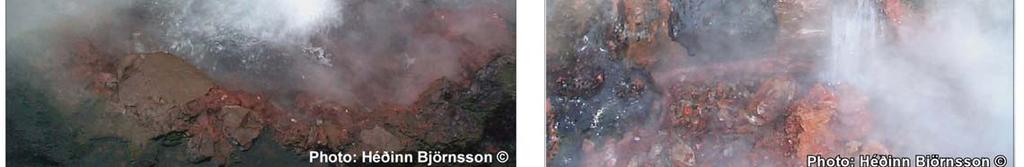
45 X N10 2 eyes, one elongated (0.40x0.10 m), and the other round (5 cm), on the N10 fracture. Are mapped as one structure due to their size 64 39'46,71070'' N 21 24'39,79554'' W Fig To the N: 94.3 ; To the E: 87.3 X X X N05 Eye with 50 cm diameter, 20 cm depth, and some discharge. Three hot points are present; the two hottest are on a N10 line where intense bubbling 64 39'46,84034' N 21 24'39,81061'' W Fig X X X N40 Eye with 60 cm diameter, 20 cm depth, on a N40 line '46,90046' N 21 24'39,60987'' W Fig. 19 Deildartunga X Vertical pipe on top of natural spring. Intense steam escape from it. Bubbles can be seen down from the open mouth of the pipe 64 39'47,26757'' N 21 24'38,96332'' W Fig X X Vertical pipe on top of natural spring. Form a N12 line with P '47,59778' N 21 24'38,77585'' W Fig X Big pool with 0.5 m diameter, 30 cm depth, against the concrete rim. Form with P a net N135 tectonic line 64 39'48,34948' N 21 24'37,98605'' W Fig. 21a X Pool with 10 cm diameter, bubbling. Form with P.92 and P a net N135 tectonic line 64 39'48,37361'' N 21 24'38,07060'' W Fig. 21a
46 X Pool with 20 cm diameter, boiling. Form with P and P a net N135 tectonic line 64 39'48,40711'' N 21 24'38,10886'' W Fig. 21a X Pool mapped manually from 1 m distance because of inaccessible conditions due to bursting boiling water 64 39'48,43948'' N 21 24'38,20536'' W Fig. 21a X Severely boiling pool in the stream, with 30 cm diameter and bursting water from beneath the surface of the stream 64 39'48,47410'' N 21 24'38,05396'' W Fig. 21a Deildartunga X Pool in the hill, with 0.5 m diameter and bursting water to 0.5 m height. Was mapped manually at 1 m distance due to inaccessible conditions 64 39'48,46710'' N 21 24'38,25005'' W Fig. 21a 98 95,4 2 eyes with 5 cm diameter, on the edge of the hill. Mapped manually at 1 m distance because of inaccessible conditions due to bursting boiling water. Form a net N90 tectonic line with P '48,53136'' N 21 24'38,42117'' W Fig. 21a X Pool with 20 cm diameter and bursting water in the stream. Form a net N90 line with P.98 and P '48,53337'' N 21 24'38,21563'' W Fig. 21a
47 X Pool with 15 cm diameter by the edge of the hill. Form a net N90 tectonic line with P.98 and P.99. Was mapped manually at 1 m distance because of inaccessible conditions due to bursting boiling water 64 39'48,52991'' N 21 24'38,40748'' W Fig. 21a X Pool with 1 m diameter and severely bursting water 64 39'48,59187'' N 21 24'38,28934'' W Fig. 21a Deildartunga X X N55 Pool in the hillside with bursting water to 0.5 m height Pool with 30 cm diameter and seriously bursting water at 0.5 m height, completely in the slope of the hill. Form a net tectonic line N55 with P '48,71597'' N 21 24'38,35540'' W 64 39'48,76359'' N 21 24'38,49646'' W Figs. 21a and 21b Fig. 21a N55 Elongated pool in the slope. Form a net tectonic line N55 with P.103, and '48,78105'' N 21 24'38,41859'' W Fig. 21a X N55 Eye with 0.50 m x 0.10 m. Manually mapped at 1 m distance due to bursting boiling water and intense steam. Form a net N55 tectonic line with P and P '48,79075'' N 21 24'38,34461'' W Fig. 21a
48 X N55 Eye with 10 cm diameter, mapped manually at 1 m distance due to bursting boiling water and intense steam. Form a net N55 tectonic line with P and P '48,81909'' N 21 24'38,29112'' W Fig. 21a X N55 Eye with 1 m diameter and bursting boiling water at 10 cm height. Form a net N55 tectonic line with P Could form a N115 tectonic line with P '48,83845'' N 21 24'38,22143'' W Fig. 21a Deildartunga X N N05 Eye with 0.5 m diameter and boiling bursting water in the stream. Could form a N115 tectonic line with P.107 Big eye with 1 m diameter in the stream. Is on the fracture N07 of P '48,82886'' N 21 24'38,14023'' W 64 39'48,91817'' N 21 24'38,11015'' W Fig. 21a Fig. 21a N05 Eye with 0.5 m diameter on the edge of the concrete protection wall. Is on the fracture N07 of P '48,97871'' N 21 24'38,13683'' W Fig. 21a X N07 Fracture N07 with 1 m long and 2-10 cm wide in the stream. Boiling water burst out of the fracture 64 39'49,12129'' N 21 24'38,11073'' W Fig. 21a X N07 Hole with 1 m diameter and bursting boiling water in the slope of the hill. Is on northerly fracture P.111 or P '49,11957'' N 21 24'38,14853'' W Figs. 21a and 21c
49 X N05 Eye with 0.5 m diameter and boiling bursting water in the stream. Form a N05 tectonic line with P and is on N05 fractures P '49,30222'' N 21 24'38,12487'' W Fig. 21a X N05 Eye in the stream with 1 m diameter and bursting boiling water at max. 0.5 m height. Forms a N05 tectonic line with P.113 and P.115, and is on N05 fractures P '49,26258'' N 21 24'38,13786'' W Fig. 21a Deildartunga X N X N150 Eye with 1.5 m diameter and bursting boiling water at 1 m height. Forms a N05 tectonic line with P , and is on N05 fractures P.118 Very big eye with 2 m diameter in a separate basin. Form a net N150 tectonic line with P and is on the N150 fracture P '49,32716'' N 21 24'38,15337'' W 64 39'49,52827'' N 21 24'38,00292'' W Fig. 21a Fig. 21a X N06 Steaming eye of 1 cm size lying directly on a N-S fracture on hard altered surface 64 39'49,44776'' N 21 24'38,37514'' W Fig. 21a 118 N150 Host fracture to geothermal points P and possibly P '49,46905'' N 21 24'38,15027'' W Fig. 21a 119 N02 Host fracture to geothermal points P , and possibly P '49,46420'' N 21 24'38,22176'' W Fig. 21a
50 X N150 3 eyes with 0.5 m diameter each and boiling water bursting to 10 cm height. Form a net N150 tectonic line with P.116 and P.121. Is at the intersection of host fractures P.123 (N72 ) and P.122 (N150 ) 64 39'49,55129'' N 21 24'38,00938'' W Fig. 21a X N150 Big bubbling eye. Form a N150 tectonic line with P.120 and P.116. Is on fracture N150 P '49,49646'' N 21 24'37,98095'' W Fig. 21a Deildartunga 122 N Host fracture to P.116 and P Host fracture to P.120, located in the western edge of the concrete basin containing P.116, P '49,44700'' N 21 24'38,01316'' W 64 39'49,54670'' N 21 24'38,07706'' W Fig. 21a Fig. 21a Litla Laug. Concrete basin 1 x 2 m on top of an old hot geothermal spring. Was cooled down and used for cold water 64 39'51,99688'' N 21 24'35,43926'' W Fig X A muddy spot 5 cm diameter in the western part of the ditch by greenhouses 64 39'51,56393'' N 21 24'35,65962'' W


51 - 51 -


52 - 52 -


53 - 53 -
54 - 54 -
55 Chapter 5 HURÐARBAK SOUTH
56 - 56 -
57 - 57 -
58 Locality Point (P) Number Max. temperature inside of the structure (in C ) Other temperature inside of the structure (in C ) Temperature in geothermal zone outside of the structure (in C ) White deposition (silica?) Algae Oxidation and possible silica deposition Bubbles Tectonic alignment of the manifestations Comment GPS coordinates Picture Hotter point in a very swampy zone with beginning of algae accumulation. A small stream is connected to it. Could form a N12 line with P.127 and P Hotter point in a very swampy zone with beginning of algae accumulation. A small stream is connected to it. Could form a N12 line with P.126 and P Hotter point in a very swampy zone with beginning of algae accumulation. A small stream is connected to it. Could form a N108 line with P '03,82205'' N 21 24'25,84715'' W 64 41'03,90939'' N 21 24'25,75341'' W 64 41'03,95823'' N 21 24'25,93623'' W Hurðarbak
59 Hotter point in very swampy zone with beginning of algae accumulation. A small stream is connected to it. Could form a N12 line with P and P '04,12462'' N 21 24'25,57412'' W , 9.5, 8.5, 5.5 Hotter point in very swampy zone with beginning of algae accumulation. A small stream is connected to it. Could form a N12 line with P '04,27411'' N 21 24'25,67289'' W Hurðarbak Hotter point in a very swampy zone with beginning of algae accumulation. A small stream is connected to it Outline of the cold geothermal area containing P Includes the only zone of swamp and small stagnant stream with special green vegetation in a frozen surrounding. Soil T at the time of mapping was - 4 C 64 41'04,58639'' N 21 24'24,63638'' W 64 41'04,51623'' N 21 24'24,73420'' W N25 Small deep swampy hole with running water in a frozen surrounding. Greener vegetation associated with the water. Air temperature at the time of measurement was C. Form a line N25 with P '06,32649'' N 21 24'25,72809'' W
60 N25 Cold spring. Small deep swampy hole with running water in a frozen surrounding. Greener vegetation associated with the water. Has some discharge. Air temperature at the time of measurement was C. Form a line N25 with P.133 and P '06,44418'' N 21 24'25,57172'' W Hurðarbak N N25 Cold spring. Small deep swampy hole with running water in a frozen surrounding. Greener vegetation associated with the water. Air temperature at the time of measurement was C. Form a line N25 with P and P Cold spring. Small deep swampy hole with running water in a frozen surrounding. Greener vegetation associated with the water. Air temperature at the time of measurement was C. Form a line N25 with P and P '06,58021'' N 21 24'25,40921'' W 64 41'06,74956'' N 21 24'25,25959'' W N25 Cold spring. Small deep swampy hole with running water in a frozen surrounding. Greener vegetation associated with the water. Air temperature at the time of measurement was C. Form a sharp tectonic lineation N25 with P '06,94193'' N 21 24'25,08690'' W
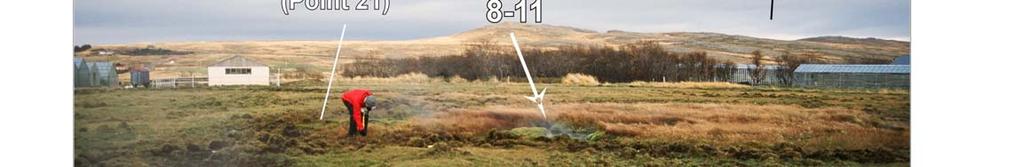
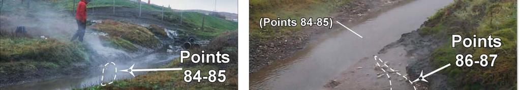
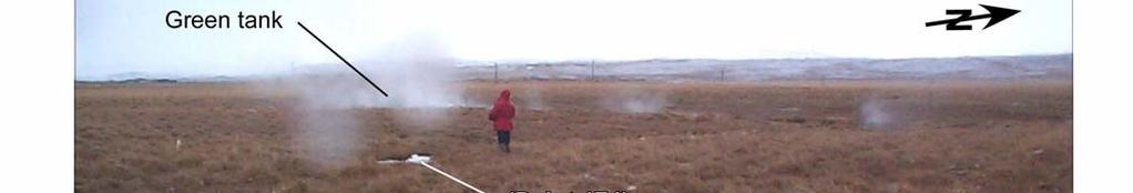
61 X X X N55 Big perfect eye with 0.5 m diameter and bursting boiling water in a hard altered rock. Form a N55 tectonic line with P '08,79716'' N 21 24'20,53249'' W Fig To the N: 94.2 X N55 Pool with 2 boiling points striking N50 together, and bursting water. Is at some 4 m SW of the green tank. Has discharge. Form a tectonic line N55 with P '08,82243'' N 21 24'20,38795'' W Fig X Outline of the area containing P and the green tank 64 41'08,99089'' N 21 24'20,40013'' W Fig. 24 Hurðarbak X X N50 Circular eye with 30 cm diameter and bursting water Elongated eye N50 with bursting boiling water 64 41'09,03654'' N 21 24'19,77619'' W 64 41'09,00526'' N 21 24'19,72761'' W Fig. 25 Fig X X X X Outline of the area containing P These points are in hard rock and have some discharge 64 41'08,97405'' N 21 24'19,77014'' W Fig X Eye of 0.30 x 0.15 m, in hard rock, with little discharge. Form a net N80 tectonic line with P.145, and with P , P.163, and P '09,22392'' N 21 24'18,23142'' W Fig X Big eye with 1 m diameter, 0.5 cm depth, and little discharge. Form a net tectonic line N80 with P.144 and with P , P.163, and P '09,22967'' N 21 24'18,05540'' W Fig
62 X X X Small eye of 10 x 5 cm, in swampy sediments Eye 25 x 15 cm, in swampy sediments with oxidation. Could form a tectonic line N80 with P '09,70041'' N 21 24'18,29588'' W 64 41'09,71161'' N 21 24'18,01280'' W 148 a 61 X Small eye with 5 cm diameter, in swampy sediments. Form a net N08 tectonic line with P.157 and P.159, P.149, P.148b, and P '09,49152'' N 21 24'17,67238'' W Hurðarbak 148 b cm to the S: m to the N: 37.6, 1 m to the NW: 42.3 X X Small eye in swampy sediments. Form a net N08 tectonic line with P.157 and P.159, P.149, P.148a, and P Hot point in swampy area. Form a net N08 tectonic line with P.157 and P.159, P.148ab, and P '09,47228'' N 21 24'17,50574'' W 64 41'09,40502'' N 21 24'17,65399'' W X Small eye of 10 x 5 cm, in swampy sediments 64 41'09,48053'' N 21 24'17,23626'' W ; 69 X X X N10 3 hot points in a swampy area forming a N10 tectonic line 64 41'09,36772'' N 21 24'17,11311'' W X X X X Big eye with 1 m diameter and 1 m depth in hard rock 64 41'09,50518'' N 21 24'16,54106'' W X Eye with 0.40 m diameter. Could form a N80 tectonic line with P , P , P.163, and P '09,25376'' N 21 24'16,51450'' W Fig
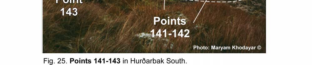
63 Eye with 5 cm diameter. Could form a N80 tectonic line with P.153 and P.155, P , P.163, and P '09,36078'' N 21 24'16,39565'' W Fig Eye with 0.50 m diameter and 0.20 m depth. Could form a N80 tectonic line with P , P , P.163, and P '09,32233'' N 21 24'16,35102'' W Fig Outline of the area containing P '09,30503'' N 21 24'16,10811'' W Hurðarbak , 67.7, 70.2, X X Group of eyes in swampy stream. Form a net N08 tectonic line with P.158 and P.159, P.149, P.148a-b, and P Eye at the N edge of a swampy stream '08,75855'' N 21 24'17,87058'' W 64 41'08,84179'' N 21 24'17,59491'' W cm to the E: 60.4 ; 80 cm to the E: 47.9 X Hot zone in stagnant portion of a stream in swampy sediments. Form a net N08 tectonic line with P , P.149, P.148a-b, and P '08,75854'' N 21 24'17,88606'' W , m to the N: 35.3 Form a net N15 tectonic line with P.162, P , and P '08,84855'' N 21 24'15,52336'' W At 0.5 m and 2 m to the NNW: 48 and 31 ; at 1 m to the SE: 34 Form a net N15 tectonic line with P.160, P , and P '08,93754'' N 21 24'15,47038'' W
64 162 Outline of the area containing P '08,97892'' N 21 24'15,35428'' W , m to the E: 22.5 ; 0.5 m to the N: 23 ; 0.5 m to the W: 38 ; 1 m to the S: 31.3 N18 3 hot points. Could form a N80 tectonic line with P , P , P.163, and P '09,35390'' N 21 24'15,67750'' W Hurðarbak X , 57.4, 78.6, 82 (is P. 164), 67, 63.2, 72.5, 68 Small eye in swampy sediments. Form a net N80 tectonic line with P , P , P.163, and P , and a net N15 tectonic line with P , P.165, and P.168 Eye with 15 cm diameter in swampy sediments. Form a N80 tectonic line with P , P , P.163, and P , and a net N15 tectonic line with P , P.164, and P.168 Outline of the area containing P.P '09,34216'' N 21 24'15,04868'' W 64 41'09,38538'' N 21 24'15,16998'' W 64 41'09,34440'' N 21 24'15,34094'' W Fig. 26 Fig Small pond with 0.50 x 0.30 m size, in swamp 64 41'09,64798'' N 21 24'15,25092'' W X 2 hot points in a swampy area. Form a net N15 tectonic line with P , and P '09,93945'' N 21 24'14,93296'' W
65 , 60, 62.8, 66, 62.3, 72.3, 78, , 39.8, 47.2 Outline of the area containing P '09,97128'' N 21 24'14,88092'' W On a NW- SE line, to the SE: 57.4, 55, 56.2 To the N: 47.5 ; at 10 cm to the NE: 29 ; at 1 m to the S: 38 ; ice at 10 cm to the SE N160 2 small eyes with 5-10 cm diameter 64 41'10,42538'' N 21 24'16,10905'' W Hurðarbak , 46.9 On a N-S line to the S, at 0.5 m, 1.5 m, and 3 m: 47.9, 42.2, 34.5 Small eye in the grass. Form a net N08 tectonic line with P , P.149, P.148a-b, and P.172 In a swampy area. Form a net N08 tectonic line with P , P.149, P.148a-b, and P '10,40897'' N 21 24'17,24222'' W 64 41'10,23961'' N 21 24'17,30539'' W 173 Outline of the area containing P Strikes N '09,23686'' N 21 24'18,44489'' W N130 Cold spring with 1 m diameter and liquid water in a frozen surrounding, outside of the geothermal zone. A stream flows from it northwards but does not reach the geothermal zone. Could be identified due to frozen surrounding ground. Form a line N130 with P '07,23124'' N 21 24'15,40904'' W Fig
66 Eye with 5 cm diameter, on the eastern side of the stream. Heats the water flowing from the cold stream P.174 from here northward 64 41'07,65565'' N 21 24'15,81348'' W Cold spring 1 x 0.5 m diameter, with liquid water in frosty surrounding grassy area. Form a N130 line with P '06,72853'' N 21 24'14,18125'' W Fig Eastern border of the stream flowing from P '07,24984'' N 21 24'15,49162'' W Hurðarbak Western border of the stream flowing from P.174 Outline of the geothermal area containing P '08,73437'' N 21 24'16,00574'' W 64 41'09,13799'' N 21 24'14,61182'' W X X X X Eye with 20 cm diameter, by the edge of the grass. Form a N165 line with P.183, and could be associated with the fracture on P.181. Silica? 64 41'18,20922'' N 21 24'10,00767'' W Fig X X X N165 Big eye with 1 m diameter, and 2 or 3 bursting zones in the middle of a fracture N '18,25083'' N 21 24'09,93121'' W Fig An abandoned wash house, including 2 pipes with steam escaping, indicating the presence of a natural spring underneath. Form a line N165 with P '18,39779'' N 21 24'09,97396'' W Fig
67 T measured at the pipe coming out of the northern part of the house P.182. GPS point indicates the possible position of the spring beneath the central part of the house. Form a line N165 with P '18,45690'' N 21 24'10,09041'' W Fig. 26 Hurðarbak X Small eye with 0.30 m diameter and bursting water in the geothermal stream 64 41'18,81440'' N 21 24'09,56053'' W Fig X X X X N20 Outline of the area containing P Area with swamp and much hard alteration '18,87573'' N 21 24'09,42306'' W Fig Orange pump house 64 41'19,28645'' N 21 24'09,04770'' W Fig


68 - 68 -
69 - 69 -


70 - 70 -
71 REFERENCES Björnsson H GPS-mapping of the geothermal manifestations in Kleppjárnsreykir, Deildartunga and Hurðarbak South in Borgarfjörður, West Iceland. Cooperative project between the University of Iceland, Faculty of Sciences and Íslenskar orkurannsóknir (Ísor), 48 p. Einarsson, P., Klein, F. W., and Björnsson, S., 1977, The Borgarfjörður earthquakes of 1974 in West Iceland, Bulletin of the Seismological Society of America, 67, p Jóhannesson, H., Sæmundsson, K., Geological map of Iceland 1: Bedrock geology. Náttúrufræðistofnun Íslands. Khodayar, M., and Einarsson, P Strike-slip faulting, normal faulting and lateral dyke injections along a single fault: Field example of the Gljúfurà Fault near a Tertiary oblique rift/transform zone, Borgarfjörður, W-Iceland, Journal of Geophysical Research, Vol. 107, NO. B5, /2001JB000150, (ETG 5, p. 1-18). Khodayar, M., Björnsson, H., Einarsson, P., and Franzson, H GPS-mapping of geothermal areas in West Iceland, Phase 1: Kleppjárnsreykir, Deildartunga, Hurðarbak South in Reykholtsdalur. An overview Short report. Íslenskar orkurannsóknir, ÍSOR-04138, 7 p
INFRARED AND SATELLITE IMAGES, AERIAL PHOTOGRAPHY
 Presented at Short Course VI on Exploration for Geothermal Resources, organized by UNU-GTP, GDC and KenGen, at Lake Bogoria and Lake Naivasha, Kenya, Oct. 27 Nov. 18, 2011. GEOTHERMAL TRAINING PROGRAMME
Structural Geology tectonics, volcanology and geothermal activity. Kristján Saemundsson ÍSOR Iceland GeoSurvey
 Structural Geology tectonics, volcanology and geothermal activity Kristján Saemundsson ÍSOR Iceland GeoSurvey Discussion will be limited to rift zone geothermal systems with sidelook on hot spot environment.
Sustainable Energy Science and Engineering Center GEOTHERMAL ENERGY. Sustainable Energy Sources. Source:
 Sustainable Energy Sources GEOTHERMAL ENERGY Earth s Temperature Profile GEOTHERMAL ENERGY Plate Tectonics Earth's crust is broken into huge plates that move apart or push together at about the rate our
General Geologic Setting and Seismicity of the FHWA Project Site in the New Madrid Seismic Zone
 General Geologic Setting and Seismicity of the FHWA Project Site in the New Madrid Seismic Zone David Hoffman University of Missouri Rolla Natural Hazards Mitigation Institute Civil, Architectural & Environmental
Interpretation of Subsurface Geological Structure of Massepe Geothermal Area Using Resistivity Data
 Proceedings World Geothermal Congress 2010 Bali, Indonesia, 25-29 April 2010 Interpretation of Subsurface Geological Structure of Massepe Geothermal Area Using Resistivity Data Ahmad Zarkasyi and Yuanno
Earth Science, (Tarbuck/Lutgens) Chapter 10: Mountain Building
 Chapter 10: Mountain Building") Earth Science, (Tarbuck/Lutgens) Chapter 10: Mountain Building 1) A(n) fault has little or no vertical movements of the two blocks. A) stick slip B) oblique slip C) strike slip D) dip slip 2) In a(n) fault,
Earth Science, (Tarbuck/Lutgens) Chapter 10: Mountain Building 1) A(n) fault has little or no vertical movements of the two blocks. A) stick slip B) oblique slip C) strike slip D) dip slip 2) In a(n) fault,
Structural Style and Tectonic Evolution of the Nakhon Basin, Gulf of Thailand
 Structural Style and Tectonic Evolution of the Nakhon Basin, Gulf of Thailand Piyaphong Chenrai Petroleum Geoscience Program, Department of Geology, Faculty of Science, Chulalongkorn University, Bangkok
Geological investigation of Skarðsfjall in the South Iceland Seismic Zone. Basement tectonics, Holocene surface ruptures, leakage, and stratigraphy
 Report Project no.: 525-012 HVAMMSVIRKJUN Geological investigation of Skarðsfjall in the South Iceland Seismic Zone Basement tectonics, Holocene surface ruptures, leakage, and stratigraphy Maryam Khodayar
Chapter 6, Part Colonizers arriving in North America found extremely landscapes. It looked different to region showing great.
 Social Studies 9 Unit 1 Worksheet Chapter 6, Part 1. 1. Colonizers arriving in North America found extremely landscapes. It looked different to region showing great. 2. The Earth is years old and is composed
How geysers work. By How Stuff Works, adapted by Newsela staff on Word Count 810 Level 850L
 How geysers work By How Stuff Works, adapted by Newsela staff on 05.06.18 Word Count 810 Level 850L Image 1. A view of Castle geyser, in the Upper Geyser Basin of Yellowstone National Park, in 2003. When
Gullfoss. 8.1 Why Has Gullfoss Two Oblique Steps?
 Gullfoss 8 The drive from Geysir to the waterfall Gullfoss along Road 35 is short. The waterfall, which constitutes the eleventh stop (11), is located in Fig. 4.1. The main features to see on the way are
Chapter 10: Deformation and Mountain Building. Fig. 10.1
 Chapter 10: Deformation and Mountain Building Fig. 10.1 OBJECTIVES Describe the processes of rock deformation and compare and contrast ductile and brittle behavior in rocks. Explain how strike and dip
TAKE HOME EXAM 8R - Geology
 Name Period Date TAKE HOME EXAM 8R - Geology PART 1 - Multiple Choice 1. A volcanic cone made up of alternating layers of lava and rock particles is a cone. a. cinder b. lava c. shield d. composite 2.
Changes to the Earth Study Guide
 Changes to the Earth Study Guide Earth has a core, crust, and mantle. The core is made of a solid inner region and a liquid outer region. The mantle is the middle layer of earth made up of molten rock.
depression above scarp scarp
 1 LAB 1: FIELD TRIP TO McKINLEYVILLE AND MOUTH OF THE MAD RIVER OBJECTIVES: a. to look at geomorphic and geologic evidence for large scale thrust-faulting of young sediments in the Humboldt Bay region
9. SLOPE AND EMBANKMENT FAILURES
 9. SLOPE AND EMBANKMENT FAILURES 9.1 Soil Slope Failures There were some soil slope failures on the banks of roadways and along Ceyhan river (Figures 9.1, 9.2 and 9.3). These are observed Mercimekköy,Yüreğir
GEOTHERMAL POTENTIAL OF ST. KITTS AND NEVIS ISLANDS
 GEOTHERMAL POTENTIAL OF ST. KITTS AND NEVIS ISLANDS By Gerald W. Huttrer Geothermal Management Company, Inc. For the Eastern Caribbean Geothermal Energy Project ( Geo- Caraibes ; G-C ) Presented Using
B. Worksheet 2 Make 1 copy for each small learning group or individual assigned to this feature
 V. WORKSHEETS A. Worksheet 1 Make 1 copy for each small learning group B. Worksheet 2 C. Worksheet 3 D. Worksheet 4 E. Worksheet 5 Worksheets A, B, C, D, and E in this section go with: Lesson 2, Section
Excursion guide NW Skåne, NGEA 01, 2018 PART 3. ASSIGNMENTS
 Excursion guide NW Skåne, NGEA 01, 2018 PART 3. ASSIGNMENTS by Associate Prof. Jonas Åkerman 1 Cover photo; The NW exposed coastline at Josefinelust with coarse beach boulders (Sw. malar ), gneiss is the
A) B) C) D) 4. Which diagram below best represents the pattern of magnetic orientation in the seafloor on the west (left) side of the ocean ridge?
 B) C) D) 4. Which diagram below best represents the pattern of magnetic orientation in the seafloor on the west (left) side of the ocean ridge?") 1. Crustal formation, which may cause the widening of an ocean, is most likely occurring at the boundary between the A) African Plate and the Eurasian Plate B) Pacific Plate and the Philippine Plate C)
1. Crustal formation, which may cause the widening of an ocean, is most likely occurring at the boundary between the A) African Plate and the Eurasian Plate B) Pacific Plate and the Philippine Plate C)
ARE YOU READY TO THINK? Look at the first slide THINK PAIR SHARE!
 ARE YOU READY TO THINK? Look at the first slide THINK PAIR SHARE! WHAT PROMINENT FEATURE CAN YOU IDENTIFY IN THIS PICTURE? What do you think the different colors represent? Who might find such a picture
Bonn, Germany MOUTAZ DALATI. General Organization for Remote Sensing ( GORS ), Syria Advisor to the General Director of GORS,
, Syria Advisor to the General Director of GORS,") Bonn, Germany Early Warning System is needed for Earthquakes disaster mitigation in Syria Case Study: Detecting and Monitoring the Active faulting zones along the Afro-Arabian-Syrian Rift System MOUTAZ
Bonn, Germany Early Warning System is needed for Earthquakes disaster mitigation in Syria Case Study: Detecting and Monitoring the Active faulting zones along the Afro-Arabian-Syrian Rift System MOUTAZ
Empirical Green s Function Analysis of the Wells, Nevada, Earthquake Source
 Nevada Bureau of Mines and Geology Special Publication 36 Empirical Green s Function Analysis of the Wells, Nevada, Earthquake Source by Mendoza, C. 1 and Hartzell S. 2 1 Centro de Geociencias, Universidad
4. The map below shows a meandering stream. Points A, B, C, and D represent locations along the stream bottom.
 1. Sediment is deposited as a river enters a lake because the A) velocity of the river decreases B) force of gravity decreases C) volume of water increases D) slope of the river increases 2. Which diagram
A physical feature of the Earth s surface
 Earth s Landforms A physical feature of the Earth s surface A physical feature of the Earth s surface LANDFORM Highest of Earth s physical features Highest of Earth s physical features MOUNTAIN Low area
GEOTHERMAL ENERGY POTENTIAL FOR LONGONOT PROSPECT, KENYA. By Mariita N. O. Kenya Electricity Generating Company
 GEOTHERMAL ENERGY POTENTIAL FOR LONGONOT PROSPECT, KENYA By Mariita N. O. Kenya Electricity Generating Company PRESENTATION OUTLINE INTRODUCTION REGIONAL SETTING GEOLOGY GEOTHERMAL MANIFESTATIONS HYDROGEOLOGY
Introduction to Prospecting. Session Two Geology
 Introduction to Prospecting Session Two Geology The Earth Earth is 4.6 billion years old (Ba). Bacteria & algae +3.5 Ba. Microscopic animals ~2 Ba. Animals ~600 million years (Ma) old. Mankind about 100,000
Earthquakes. Earthquakes are caused by a sudden release of energy
 Earthquakes Earthquakes are caused by a sudden release of energy The amount of energy released determines the magnitude of the earthquake Seismic waves carry the energy away from its origin Fig. 18.1 Origin
Rate the Volcanic effects above. Justify your answer.
 Tsunami Composite The displacement of water can generate huge waves travelling up to 600kph. On reaching shallow coastal areas these rapidly grow in height and power. Floods Shield Composite Volcanic eruptions
COSMORPHOLOGY - May 2009
 Name COSMORPHOLOGY - May 2009 Geologic landforms Purpose: By studying aerial photographs you will learn to identify different kinds of geologic features based on their different morphologies and learn
Answers: Internal Processes and Structures (Isostasy)
") Answers: Internal Processes and Structures (Isostasy) 1. Analyse the adjustment of the crust to changes in loads associated with volcanism, mountain building, erosion, and glaciation by using the concept
Answers: Internal Processes and Structures (Isostasy) 1. Analyse the adjustment of the crust to changes in loads associated with volcanism, mountain building, erosion, and glaciation by using the concept
Marine Science and Oceanography
 Marine Science and Oceanography Marine geology- study of the ocean floor Physical oceanography- study of waves, currents, and tides Marine biology study of nature and distribution of marine organisms Chemical
3. GEOLOGY. 3.1 Introduction. 3.2 Results and Discussion Regional Geology Surficial Geology Mine Study Area
 3. GEOLOGY 3.1 Introduction This chapter discusses the baseline study of the geology and mineralization characteristics of the mine study area. The study consolidates existing geological data and exploration
Metals in geothermal fluids and metal precipitations in surface pipelines in Iceland can these been utilized?
 Metals in geothermal fluids and metal precipitations in surface pipelines in Iceland can these been utilized? Dr. Vigdís Hardardóttir, Iceland GeoSurvey - ÍSOR Msc. NordMin course Iceland Nov. 2016 Black
24. Ocean Basins p
 24. Ocean Basins p. 350-372 Background The majority of the planet is covered by ocean- about %. So the majority of the Earth s crust is. This crust is hidden from view beneath the water so it is not as
Lecture Outline Friday March 2 thru Wednesday March 7, 2018
 Lecture Outline Friday March 2 thru Wednesday March 7, 2018 Questions? Lecture Exam Friday March 9, 2018 Same time, Same room Bring Pencils and WSU ID 50 question Multiple Choice, Computer Graded Interlude
Continental Margin Geology of Korea : Review and constraints on the opening of the East Sea (Japan Sea)
") Continental Margin Geology of Korea : Review and constraints on the opening of the East Sea (Japan Sea) Han-Joon Kim Marine Satellite & Observation Tech. Korea Ocean Research and Development Institute
Continental Margin Geology of Korea : Review and constraints on the opening of the East Sea (Japan Sea) Han-Joon Kim Marine Satellite & Observation Tech. Korea Ocean Research and Development Institute
Evaluation of Structural Geology of Jabal Omar
 International Journal of Engineering Research and Development e-issn: 2278-067X, p-issn: 2278-800X, www.ijerd.com Volume 11, Issue 01 (January 2015), PP.67-72 Dafalla Siddig Dafalla * and Ibrahim Abdel
Geothermal Potential Assessment in Northern Rwanda
 Geothermal Potential Assessment in Northern Rwanda 2 nd African Rift Geothermal Conference Entebbe, Uganda Ngaruye, Jean-Claude 1) Jolie, Egbert 2) 1) Rwanda Geology and Mining Authority, OGMR 2) Federal
Practice Questions: Plate Tectonics
 Practice Questions: Plate Tectonics 1. Base your answer to the following question on The block diagram below shows the boundary between two tectonic plates. Which type of plate boundary is shown? A) divergent
Jocelyn Karen Campbell
 THE UNCERTAINTIES IN ASSESSING THE IMPACT OF REGIONAL SEISMICITY AT THE WIL SITE Statement of Evidence by Jocelyn Karen Campbell A CANTERBURY FAULTS coded by type CHARACTERISTICS OF THRUST FAULTS IN CANTERBURY
USU 1360 TECTONICS / PROCESSES
 USU 1360 TECTONICS / PROCESSES Observe the world map and each enlargement Pacific Northwest Tibet South America Japan 03.00.a1 South Atlantic Arabian Peninsula Observe features near the Pacific Northwest
Geothermal Systems: Geologic Origins of a Vast Energy Resource
 Geothermal Systems: Geologic Origins of a Vast Energy Resource Energy From the Earth Energy-Land-Water Connections Speaker Series James E. Faulds, PhD Nevada State Geologist and Professor Nevada Bureau
MEMO. TO: Dennis Lapoint CC: FROM: Eriaan Wirosono DATE: April, 20 th 2014 SUBJECT: Exploration activity report March-April 2014_EW
 TO: Dennis Lapoint CC: FROM: Eriaan Wirosono DATE: April, 20 th 2014 SUBJECT: Exploration activity report March-April 2014_EW MEMO 1. Highlights and Productivity Overview pan sampling on target Areas 1
The Geology of Two Lights State Park. Cape Elizabeth, Maine
 Maine Geologic Facts and Localities June, 2002 Cape Elizabeth, Maine 43 33 33.48 N, 70 12 13.32 W Text by Henry N. Berry IV and Robert G. Marvinney, Department of Agriculture, Conservation & Forestry 1
Which map shows the stream drainage pattern that most likely formed on the surface of this volcano? A) B)
 B)") 1. When snow cover on the land melts, the water will most likely become surface runoff if the land surface is A) frozen B) porous C) grass covered D) unconsolidated gravel Base your answers to questions
1. When snow cover on the land melts, the water will most likely become surface runoff if the land surface is A) frozen B) porous C) grass covered D) unconsolidated gravel Base your answers to questions
Geology (Mellow) Hike, Santa Lucia Memorial Park February 16, I. Overview of Santa Lucia Range geology and tectonic history
 Hike, Santa Lucia Memorial Park February 16, I. Overview of Santa Lucia Range geology and tectonic history") Geology (Mellow) Hike, Santa Lucia Memorial Park February 16, 2015 I. Overview of Santa Lucia Range geology and tectonic history A. Basement Rocks 1. Salinian Block Rocks Sierra Nevada Type, continental
Geology (Mellow) Hike, Santa Lucia Memorial Park February 16, 2015 I. Overview of Santa Lucia Range geology and tectonic history A. Basement Rocks 1. Salinian Block Rocks Sierra Nevada Type, continental
General Editor: Vince Russett
 YCCCART 2014/Y20 North Somerset HER 2015/11 Manual survey using an electronic, hydryostatic level (NIVCOMP) at Wemberham Roman Villa YATTON, CONGRESBURY, CLAVERHAM AND CLEEVE ARCHAEOLOGICAL RESEARCH TEAM
JOURNAL OF GEOPHYSICAL RESEARCH, VOL. 107, NO. B5, 2103, /2001JB000150, 2002
 JOURNAL OF GEOPHYSICAL RESEARCH, VOL. 107, NO. B5, 2103, 10.1029/2001JB000150, 2002 Strike-slip faulting, normal faulting, and lateral dike injections along a single fault: Field example of the Gljúfurá
From Punchbowl to Panum: Long Valley Volcanism and the Mono-Inyo Crater Chain
 From Punchbowl to Panum: Leslie Schaffer E105 2002 Final Paper Long Valley Volcanism and the Mono-Inyo Crater Chain Figure 1. After a sequence of earthquakes during the late 1970 s to the early 1980 s
Chapter 7: Volcanoes 8/18/2014. Section 1 (Volcanoes and Plate Tectonics) 8 th Grade. Ring of Fire
 8 th Grade. Ring of Fire") Section 1 (Volcanoes and Plate Tectonics) Chapter 7: Volcanoes 8 th Grade Ring of Fire a major belt of es that rims the Pacific Ocean Volcanic belts form along the boundaries of Earth s plates as they
Section 1 (Volcanoes and Plate Tectonics) Chapter 7: Volcanoes 8 th Grade Ring of Fire a major belt of es that rims the Pacific Ocean Volcanic belts form along the boundaries of Earth s plates as they
Lab 1: Plate Tectonics April 2, 2009
 Name: Lab 1: Plate Tectonics April 2, 2009 Objective: Students will be introduced to the theory of plate tectonics and different styles of plate margins and interactions. Introduction The planet can be
Examining the Terrestrial Planets (Chapter 20)
") GEOLOGY 306 Laboratory Instructor: TERRY J. BOROUGHS NAME: Examining the Terrestrial Planets (Chapter 20) For this assignment you will require: a calculator, colored pencils, a metric ruler, and your geology
GEOLOGY 306 Laboratory Instructor: TERRY J. BOROUGHS NAME: Examining the Terrestrial Planets (Chapter 20) For this assignment you will require: a calculator, colored pencils, a metric ruler, and your geology
Geology and New England Landscapes
 Geology and New England Landscapes Jim Turenne, CPSS USDA-NRCS Warwick, RI. http://nesoil.com Why Geology? Provides the big picture of site conditions. Major part of soil formation (parent material and
Geophysical Surveys of The Geothermal System of The Lakes District Rift, Ethiopia
 Geophysical Surveys of The Geothermal System of The Lakes District Rift, Ethiopia By: Befekadu Oluma By: Geophysics Department Geological Survey of Ethiopia The formation of the rift was preceded by a
Plate Tectonics. entirely rock both and rock
 Plate Tectonics I. Tectonics A. Tectonic Forces are forces generated from within Earth causing rock to become. B. 1. The study of the origin and arrangement of Earth surface including mountain belts, continents,
FIREPLACE GEOLOGY. Dining Hall
 FIREPLACE GEOLOGY Dining Hall The Dining Hall fireplace represents a slice through a Cascade Mountain volcano. Volcanoes are formed from molten magma rising up from within the Earth s crust. Magma that
Finding Fault Geologic History from a Road Cut
 Finding Fault Geologic History from a Road Cut Elisabeth M. Price, DD LaPointe, and Jonathan G. Price 4 July 2005 Introduction Earth science is an important science to present to students because it directly
Earth s Continents and Seafloors. GEOL100 Physical Geology Ray Rector - Instructor
 Earth s Continents and Seafloors GEOL100 Physical Geology Ray Rector - Instructor OCEAN BASINS and CONTINENTAL PLATFORMS Key Concepts I. Earth s rocky surface covered by of two types of crust Dense, thin,
Earth and Space Science Semester 2 Exam Review. Part 1. - Convection currents circulate in the Asthenosphere located in the Upper Mantle.
 Earth and Space Science 2015 Semester 2 Exam Review Part 1 Convection -A form of heat transfer. - Convection currents circulate in the Asthenosphere located in the Upper Mantle. - Source of heat is from
UNDERSTANDING GEOLOGIC M APS
 Name: Lab Section: work in groups, but each person turns in his/her own GEOSCIENCE 001 L AB UNDERSTANDING GEOLOGIC M APS Geologic maps are colorful and even beautiful, but they also contain an amazing
Course Syllabus (Contents Part 8) Geothermal Energy
 Geothermal Energy") Course Syllabus (Contents Part 8) PART 8 GEOTHERMAL ENERGY Geothermal energy Typical geothermal gradient Global geothermal resource Plate boundaries & hot spots Major geothermal regions US geothermal resources
Course Syllabus (Contents Part 8) PART 8 GEOTHERMAL ENERGY Geothermal energy Typical geothermal gradient Global geothermal resource Plate boundaries & hot spots Major geothermal regions US geothermal resources
Visualizing Earth Science. Chapter Overview. Volcanoes and Eruption Types. By Z. Merali and B. F. Skinner. Chapter 9 Volcanism and Other
 Visualizing Earth Science By Z. Merali and B. F. Skinner Chapter 9 Volcanism and Other Igneous Processes Volcanoes types and effects of eruption Chapter Overview Melting and cooling of rocks Geological
Characterization of Subsurface Permeability of the Olkaria East Geothermal Field
 PROCEEDINGS, 44th Workshop on Geothermal Reservoir Engineering Stanford University, Stanford, California, February 11-13, 2019 SGP-TR-214 Characterization of Subsurface Permeability of the Olkaria East
4 Deforming the Earth s Crust
 CHAPTER 7 4 Deforming the Earth s Crust SECTION Plate Tectonics BEFORE YOU READ After you read this section, you should be able to answer these questions: What happens when rock is placed under stress?
Plate Tectonics: A Scientific Revolution Unfolds
 Chapter 2 Lecture Earth: An Introduction to Physical Geology Eleventh Edition Plate Tectonics: A Scientific Revolution Unfolds Tarbuck and Lutgens From Continental Drift to Plate Tectonics Prior to the
B.C. s Offshore Oil and Gas: a Guide to the Geology and Resources.
 B.C. s Offshore Oil and Gas: a Guide to the Geology and Resources. Introduction Beneath the offshore regions of British Columbia are four moderately large, geologically young sedimentary basins (Figure
Structural Controls on the Chemistry and Output of the Wells in the Olkaria Geothermal Field, Kenya
 Proceedings 5 th African Rift geothermal Conference Arusha, Tanzania, 29-31 October 2014 Structural Controls on the Chemistry and Output of the Wells in the Olkaria Geothermal Field, Kenya (Wamalwa, R.N.)
Lecture Outline Friday January 12 Friday January 19, 2018
 Lecture Outline Friday January 12 Friday January 19, 2018 Questions?? Key Points for today The structure of the Earth Introduction to Plate Tectonic Theory and Convection Chapter 2 Development of the Plate
Activity Submitted by Tim Schroeder, Bennington College,
 Structural Analysis of a Hot Dry Rock Geothermal Energy System Activity Submitted by Tim Schroeder, Bennington College, tschroeder@bennington.edu Description: This project applies basic geologic skills
Study Guide: Unit 3. Density and Pressure: You should be able to answer the types of questions given in the end of module questions.
 IDS 102 Study Guide: Unit 3 The purpose of this study guide is to help you prepare for the third exam by focusing your studying and providing example essay questions. In the Focus On section you will find
3. PLATE TECTONICS LAST NAME (ALL IN CAPS): FIRST NAME: PLATES
: FIRST NAME: PLATES") LAST NAME (ALL IN CAPS): FIRST NAME: PLATES 3. PLATE TECTONICS The outer layers of the Earth are divided into the lithosphere and asthenosphere. The division is based on differences in mechanical properties
LAST NAME (ALL IN CAPS): FIRST NAME: PLATES 3. PLATE TECTONICS The outer layers of the Earth are divided into the lithosphere and asthenosphere. The division is based on differences in mechanical properties
TORFAJÖKULL, ICELAND A RHYOLITE VOLCANO AND ITS GEOTHERMAL RESOURCE
 Presented at Short Course VI on Exploration for Geothermal Resources, organized by UNU-GTP, GDC and KenGen, at Lake Bogoria and Lake Naivasha, Kenya, Oct. 27 Nov. 18, 2011. GEOTHERMAL TRAINING PROGRAMME
PLATE TECTONIC PROCESSES
 Lab 9 Name Sec PLATE TECTONIC PROCESSES 1. Fill in the blank spaces on the chart with the correct answers. Refer to figures 2.3, 2.4 p.33 (2.2 and 2.3 on p. 23) as needed. 2. With your knowledge of different
In this lab, we will study and analyze geologic maps from a few regions, including the Grand Canyon, western Wyoming, and coastal California.
 Name: Lab Section: work in groups, but each person turns in his/her own GEOSCIENCE 001 LAB UNDERSTANDING GEOLOGIC MAPS Geologic maps are colorful and even beautiful, but they also contain an amazing amount
Basin & Range / Mojave Desert
 Basin & Range / Mojave Desert Basin & Range vs. Great Basin 1 2/20/2016 An overview of the last horst Basin and Range / Mojave Desert Summary: Granitic, volcanic, marine sedimentary, non marine sedimentary,
Terrain Units PALEOGEOGRAPHY: LANDFORM CREATION. Present Geology of NYS. Detailed Geologic Map of NYS
 NYS TOPOGRAPHY Why so? PALEOGEOGRAPHY: LANDFORM CREATION Prof. Anthony Grande AFG 014 Present Geology of NYS Detailed Geologic Map of NYS Generalized Geology Detailed Geology Hot links to the fold out
Figure 1 The map shows the top view of a meandering stream as it enters a lake. At which points along the stream are erosion and deposition dominant?
 1. In which type of climate does chemical weathering usually occur most rapidly? 1. hot and dry 3. cold and dry 2. hot and wet 4. cold and wet 2. Figure 1 The map shows the top view of a meandering stream
Seismic Reflection Imaging across the Johnson Ranch, Valley County, Idaho
 Seismic Reflection Imaging across the Johnson Ranch, Valley County, Idaho Report Prepared for the Skyline Corporation Lee M. Liberty Center for Geophysical Investigation of the Shallow Subsurface (CGISS)
Geology and Hydrothermal Alteration in the Reservoir of the Hellisheiði High Temperature System, SW-Iceland
 Proceedings World Geothermal Congress 2010 Bali, Indonesia, 25-9 April 2010 Geology and Hydrothermal Alteration in the Reservoir of the Hellisheiði High Temperature System, SW-Iceland Helga Margrét Helgadóttir,
GEOLOGY 101 LABORATORY LAB
 Student Name: College: Grade: GEOLOGY 101 LABORATORY LAB Isostasy and Plate Tectonics Understanding and Analyzing Vertical and Horizontal Plate Motion Part I. Density and Isostatic Equilibrium Introduction:
Earthquakes in Barcelonnette!
 Barcelonnette in the Ubaye valley : the landscape results of large deformations during the alpine orogene (40 5 Myr in this area) and the succession of Quaternary glaciations. The sedimentary rocks are
Landforms in Canada. Canada is made up of three dis;nct types of landforms: Canadian Shield Highlands Lowlands
 Canada s Landforms What is a Landform? A landform is any physical feature of the Earth s surface having a characteris;c, recognizable shape, produced by natural causes. Landforms include major features
Mark S. Nordberg Geology and Groundwater Investigations Section North Central Region Office California Department of Water Resources
 Mark S. Nordberg Geology and Groundwater Investigations Section North Central Region Office California Department of Water Resources Ukiah Drought Workshop July 29, 2009 Groundwater 101 Groundwater is
Overview of the Seismic Source Characterization for the Palo Verde Nuclear Generating Station
 Overview of the Seismic Source Characterization for the Palo Verde Nuclear Generating Station Scott Lindvall SSC TI Team Lead Palo Verde SSC SSHAC Level 3 Project Tuesday, March 19, 2013 1 Questions from
Map shows 3 main features of ocean floor
 Map shows 3 main features of ocean floor 2017 Pearson Education, Inc. Chapter 3 Marine Provinces 2017 Pearson Education, Inc. 1 Chapter 3 Overview The study of bathymetry determines ocean depths and ocean
Science 10 PROVINCIAL EXAM STUDY BOOKLET. Unit 4. Earth Science
 Science 10 PROVNCAL EXAM STUDY BOOKLET Unit 4 Earth Science Student nstructions 1. Ensure that you have blank paper and a Data Booklet. 2. Record all answers on a separate piece of paper. 3. Answer keys
Images from: Boston.com
 Images from: Boston.com Ireland in the shadow of a volcano: Understanding the 2010 eruption at Eyjafjallajökull, Iceland. Chris Bean, School of Geological Sciences, UCD. World Quakes and Volcanoes 1960-2010
4 Deforming the Earth s Crust
 CHAPTER 7 4 Deforming the Earth s Crust SECTION Plate Tectonics BEFORE YOU READ After you read this section, you should be able to answer these questions: What happens when rock is placed under stress?
Lecture # 6. Geological Structures
 1 Lecture # 6 Geological Structures ( Folds, Faults and Joints) Instructor: Dr. Attaullah Shah Department of Civil Engineering Swedish College of Engineering and Technology-Wah Cantt. 2 The wavy undulations
Heat (& Mass) Transfer. conceptual models of heat transfer. large scale controls on fluid movement. distribution of vapor-saturated conditions
 Transfer. conceptual models of heat transfer. large scale controls on fluid movement. distribution of vapor-saturated conditions") Heat (& Mass) Transfer conceptual models of heat transfer temperature-pressure gradients large scale controls on fluid movement distribution of vapor-saturated conditions fluid flow paths surface manifestations
Heat (& Mass) Transfer conceptual models of heat transfer temperature-pressure gradients large scale controls on fluid movement distribution of vapor-saturated conditions fluid flow paths surface manifestations
MAPPING BEDROCK: Verifying Depth to Bedrock in Calumet County using Seismic Refraction
 MAPPING BEDROCK: Verifying Depth to Bedrock in Calumet County using Seismic Refraction Revised December 13, 2011 Dave Hart Wisconsin Geological and Natural History Survey INTRODUCTION Seismic refraction
MAR110 LECTURE #6 West Coast Earthquakes & Hot Spots
 17 September 2007 Lecture 6 West Coast Earthquakes & Hot Spots 1 MAR110 LECTURE #6 West Coast Earthquakes & Hot Spots Figure 6.1 Plate Formation & Subduction Destruction The formation of the ocean crust
Integrated Geophysical Model for Suswa Geothermal Prospect using Resistivity, Seismics and Gravity Survey Data in Kenya
 Proceedings World Geothermal Congress 2015 Melbourne, Australia, 19-25 April 2015 Integrated Geophysical Model for Suswa Geothermal Prospect using Resistivity, Seismics and Gravity Survey Data in Kenya
Clyde River Landslide
 Clyde River Landslide Department of Geology, Perkins Hall, University of Vermont, Burlington, VT 05405 Abstract: This paper investigates a landslide on the Clyde River in Newport, Vermont. The landslide
Wind Mountain Project Summary Memo Feeder Program
 A Manex Resource Group Company Wind Mountain Project Summary Memo Feeder Program J.A. Kizis, Jr., February 07, 2018 Assays have been received for both holes drilled at Wind Mountain during late 2017 and
Description of faults
 GLG310 Structural Geology Description of faults Horizontal stretch Crustal thickness Regional elevation Regional character Issues Normal Thrust/reverse Strike-slip >1 1 in one direction and < 1 in
Plate Tectonics Lab II: Background Information
 Plate Tectonics Lab II: Background Information This lab is based on a UW ESS101 Lab. Note: Hand in only the Answer Sheet at the back of this guide to your Instructor Introduction One of the more fundamental
A comparison of structural styles and prospectivity along the Atlantic margin from Senegal to Benin. Peter Conn*, Ian Deighton* & Dario Chisari*
 A comparison of structural styles and prospectivity along the Atlantic margin from Senegal to Benin Overview Peter Conn*, Ian Deighton* & Dario Chisari* * TGS, Millbank House, Surbiton, UK, KT6 6AP The
Overview of Indonesian Geothermal System
 Overview of Indonesian Geothermal System The Resources Beyond High Enthalpy Magmatic/Volcanic Systems By Dr.Eng. Suryantini ITB 4/3/2017 1 Outline Current Condition of Indonesian Geothermal Resources and